
 California Highways:
Click here for a key to the symbols used. An explanation of acronyms may be found at the bottom of the page.
 Routing
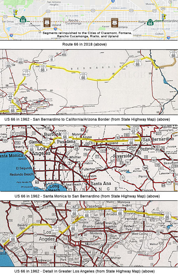 (a) Route 66 is from:
(1) Route 210 near San Dimas to the eastern city limit of the City of Pomona.
(2) The eastern city limit of the City of Rialto to Route 215 in San Bernardino.
(b) The relinquished former portions of Route 66 within the city limits of the Cities of Claremont, Fontana, Rancho Cucamonga, Rialto, and Upland are not state highways and are not eligible for adoption under Section 81. For the portions of Route 66 relinquished under this section, the Cities of Claremont, Fontana, Rancho Cucamonga, Rialto, and Upland shall maintain within their respective jurisdictions signs directing motorists to the continuation of Route 66 and ensure the continuity of traffic flow on the relinquished portions of Route 66, including any traffic signal progression.
 Post 1964 Signage History
▸As defined in 1963, this route ran from Route 30 near San Dimas to San Bernardino. The portions of "US 66" W of Route 30 were part of Route 248.
US 66 remained signed over the corridor of state Route 66 (and Route 248) until the completion of I-40 in the Bristol Mountains during 1972. Route 66 (with California signage) appears signed as a State Highway for the first time on the 1975 Caltrans Map.
▸In 1986, Chapter 928 changed the terminus of the route to be Route 215 in San Bernardino.
▸In 1999, this was changed to start at Route 210 instead of Route 30, reflecting the 1998 renaming of Route 30 (AB 1650, Ch 724, 10/10/99). This route is not signed in Los Angeles County.
▸In 2002, both SB 246 and SB 857 changed the definition of the route (perhaps without realizing it) from "Route 210 near San Dimas" to "Route 30 in La Verne". (Yes, Route 30— I guess the fact checkers were asleep).
▸In 2002, SB 246 (Chapter 248, 8/26/2002) permitted the portion of Route 66 in the City of Rancho Cucamonga to be relinquished to the city. However, the city was required to ensure the continuity of traffic flow on the relinquished portion of Route 66, including any traffic signal progressions, and to maintain signs directing motorists to the continuation of Route 66. That change was also captured by SB 857 (Chapter 251, 8/26/2002), which also placed similar requirements on the city of Fontana.
The Rancho Cucamonga portions were considered for relinquishment in April 2003 and again in May 2003: 08-SBd-66-PM 4.1/10.9 Route 66 in the City of Rancho Cucamonga.
▸In 2006, AB 3030 (Chapter 507, 9/27/2006) permitted the relinquishment of the portion of Route 66 in the City of Upland. This segment was up for the relinquishment by the CTC in December 2007.
In 2008, SB 1366 (Chapter 717, 9/30/2008) permitted the relinquishment of
the portion of Route 66 in the City of Rialto. It also changed the origin
of the route: Route 210 in La Verne near San Dimas
In April 2009, the CTC relinquished right of way in the city of Rialto on Route 66, under terms and conditions as stated in Amendment No. 1 to Relinquishment Agreement No. 1419, dated March 16, 2009, determined to be in the best interest of the State. Authorized by Chapter 717, Statutes of 2008, which amended Section 366 of the Streets and Highways Code.
▸In 2010, SB 993 (Chapter 499, 9/28/2010) changed the definition again to indicate portions of the route that have been relinquished or that have been authorized to be relinquished, including adding relinquishment to the City of Claremont that portion of Route 66 within its city limits or sphere of influence under specified conditions. This split the route into two segments, with a continuous relinquishment between the Los Angeles-San Bernardino county line at the western city limit of the City of Upland and the eastern city limit of the City of Fontana near Maple Avenue. Subsections (b) and (c) were also reworded; the previous (b) was:
(b) (1) Notwithstanding subdivision (a), the commission may relinquish to the City of Fontana, the City of Rancho Cucamonga, the City of Rialto, and the City of Upland the respective portion of Route 66 that is located within the city limits or the sphere of influence of each city, upon terms and conditions the commission finds to be in the best interests of the state. (2) A relinquishment under this subdivision shall become effective immediately following the recordation by the county recorder of the relinquishment resolution containing the commission's approval of the terms and conditions of the relinquishment. (3) On and after the effective date of the relinquishment, both of the following shall occur: (A) The portion of Route 66 relinquished under this subdivision shall cease to be a state highway. (B) The portion of Route 66 relinquished under this subdivision may not be considered for future adoption under Section 81. (c) The city shall ensure the continuity of traffic flow on the relinquished portion of Route 66, including any traffic signal progression. (d) For relinquished portions of Route 66, the city shall maintain signs directing motorists to the continuation of Route 66.
▸In September 2012, AB 2679, Chapter 769 adjusted the words of the legislative definition to acknowledge the relinquishment in Rialto.
In May 2012, it was reported that the Claremont City Council members unanimously approved an agreement with Caltrans that resulted in Claremont assuming ownership of Foothill within city limits. The process took 10 years. In February 2011, the city and Caltrans negotiated an agreement to settle the relinquishment of $5.7 million needed to maintain the street. Funding was just identified. The allocation of the money must occur at the state Transportation Commission meeting in June or the funding will be lost, which is why the item came up at a council meeting in May 2012. The money will go toward a host of upgrades. Annual routine maintenance will cost $120,000, which will be funded with gas tax funds. When the $5.7 million is received, there will be $200,000 worth of work done within six months to make improvements required by the Americans with Disabilities Act and to correct traffic safety conditions. One of the first projects will be modifying a street signal at Mountain Avenue. The area has a high accident rate because of left-turn issues.
In June 2012, the CTC relinquished right of way in the city of Claremont on Route 66 between the city limits of Pomona and Upland, under terms and conditions as stated in the relinquishment agreement dated May 25, 2012, determined to be in the best interest of the State. Authorized by Chapter 499, Statutes of 2010, which amended Section 366 of the Streets and Highways Code.
▸In 2013, Chapter 525 (SB 788, 10/9/13) clarified the definition yet again to reflect relinquishments:
(a) Route 66 is from:
(1) Route 210 near San Dimas to the
eastern city limit of the City of Pomona the Los Angeles-San
Bernardino county line at the western city limit of the City of Upland.
(2) The eastern city limit of the City of Rialto
Fontana near Maple Avenue to Route 215 in San Bernardino.
(b) The relinquished former portions of Route 66 within the city limits of the Cities of Claremont, Fontana, Rancho Cucamonga, Rialto, and Upland are not state highways and are not eligible for adoption under Section 81. For the portions of Route 66 relinquished under this section, the Cities of Claremont, Fontana, Rancho Cucamonga, Rialto, and Upland shall maintain within their respective jurisdictions signs directing motorists to the continuation of Route 66 and ensure the continuity of traffic flow on the relinquished portions of Route 66, including any traffic signal progression.
(c) (1) Notwithstanding subdivision (a), the commission may relinquish to the City of Claremont the respective portion of Route 66 that is located within the city limits or the sphere of influence of each city, upon terms and conditions the commission finds to be in the best interests of the state.
(2) A relinquishment under this subdivision shall become effective immediately following the recordation by the county recorder of the relinquishment resolution containing the commission's approval of the terms and conditions of the relinquishment.
(3) On and after the effective date of the relinquishment, both of the following shall occur: (A) The portion of Route 66 relinquished under this subdivision shall cease to be a state highway. (B) The portion of Route 66 relinquished under this subdivision may not be considered for future adoption under Section 81.
(4) The City of Claremont shall ensure the continuity of traffic flow on the relinquished portion of Route 66, including any traffic signal progression.
(5) For the relinquished portion of Route 66, the City of Claremont shall maintain signs directing motorists to the continuation of Route 66.
 History and Signage Information
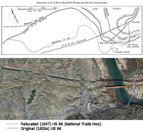
Discussion Note: Unlike most of the discussions on this site, the discussion below moves from East to West. This is primarily because most discussions of Route 66 run it from Chicago to Los Angeles, as that was the primary direction of travel. In terms of postmiles (i.e., the STATUS section), however, the discussion goes in postmile order, from West to East.

 The brief routing statement doesn't do this route justice, for it is what is left of old US 66. US 66 began its life as US 60, in the
original 1926 US highways plan. It entered the state at Topock AZ, and
extended westward through Barstow to San Bernardino and Los Angeles,
ending in Santa Monica.
The brief routing statement doesn't do this route justice, for it is what is left of old US 66. US 66 began its life as US 60, in the
original 1926 US highways plan. It entered the state at Topock AZ, and
extended westward through Barstow to San Bernardino and Los Angeles,
ending in Santa Monica.
In April of 1912 the National Old Trails Road ("NOTR") was organized with
the goal of signing a trans-continental highway between Baltimore and Los
Angeles. Building a modern road for automotive use through the Mojave
Desert of California would prove to be particularly difficult as State
Highway Maintenance didn't exist and the general path of travel was
alongside the service routes of railroads. The first Auto Trail through
Cajon Pass was the Santa Fe-Grand Canyon Needles National Highway which
was first signed in Cajon Pass by 1913. NOTR organizers later adopted the
routing of the Santa Fe-Grand Canyon Needles National Highway in the
western United States by 1914. The NOTR was able secure funding to pave
the route through Cajon Pass and construct the 1914 Crowder Canyon Bridge.
In 1916 Second State Highway Bond Act authorized a new State Highway
between San Bernardino north to Barstow which would incorporate the NOTR
over Cajon Pass. This new State Highway was known as LRN 31.
(Source: Gribblenation Blog: Cajon Pass; Cajon Pass Toll Road, National Old Trails Road, US Route 66/91/395 and Interstate 15)
In 1928, it was formally renumbered as US 66, and defined as the route from Los Angeles through San Fernando (which might have been a typo in CHPW), San Bernardino, Victorville, Barstow, Ludlow, Daggett, to the Arizona-California state line just W of Topock AZ. In general, this routing ran to Needles along LRN 58 (defined in 1919). The route was along the National Trails Highway, Park Moabi Road, File Mile Station Road, and Front St./Broadway in Needles. It then ran along Goffs Road through Arrowhead Junction and Goffs, and connected with the "National Trails Highway" through Essex, Amboy, and Newberry to Daggett (this was also LRN 58). In 1931, the alignment ran along Mt. Springs Road to the National Trails Highway. This route has since been bypassed by I-40, and a number of the original roads are signed as Historic US 66 or as State Route 66. Moving from East to West....
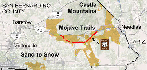
 In 1947, the Department of Highways moved US 66 to a new
alignment and a new bridge across the Colorado River. The movement to the
Red Rock Bridge permitted elimination of one of the narrowest and
crookedest portions of US 66. The cost to move to the Red Rock Bridge was
only $147K, of which $71.5K was spent replacing the rail deck of the
bridge, $70.5K was spent widening the old railroad approach, and $5K was
spent to connect it to the existing US 66. The opportunity to replace the
bridge arose when ATSF obtained approval to build a new RR bridge 500'
upstream in 1942. The Red Rock bridge was set to be scrapped for its
steel, but the Army was interested in the bridge and analysis showed that
the need for steel would be over before the scrapping could occur.
Negotiations were reopened, and the bridge was finally donated to the
states in 1944. The history of the bridge going back to Civil War days may
be found in the July/August 1947 issue of CHPW. Note that an act of Congress in December 1944 was required to confirm that ATSF could transfer the bridge. The old
bridge was completed in 1916, and had a load limit of 11 tons. The
construction of Parker Dam also served to submerge the steel supports of
the old bridge. The new bridge was designed to support 94 ton trains. Note
that it appears that the both the old bridge and the Red Rock bridge (or
at least their locations) are still in use as of 2013 -- the Red Rock
Bridge still appears to be supporting the traffic of I-40 (although it may
have been rebuilt -- it still is in the correct location with respect to
the RR bridge), and the original 1916 bridge appears to now be supporting
a pipeline.
In 1947, the Department of Highways moved US 66 to a new
alignment and a new bridge across the Colorado River. The movement to the
Red Rock Bridge permitted elimination of one of the narrowest and
crookedest portions of US 66. The cost to move to the Red Rock Bridge was
only $147K, of which $71.5K was spent replacing the rail deck of the
bridge, $70.5K was spent widening the old railroad approach, and $5K was
spent to connect it to the existing US 66. The opportunity to replace the
bridge arose when ATSF obtained approval to build a new RR bridge 500'
upstream in 1942. The Red Rock bridge was set to be scrapped for its
steel, but the Army was interested in the bridge and analysis showed that
the need for steel would be over before the scrapping could occur.
Negotiations were reopened, and the bridge was finally donated to the
states in 1944. The history of the bridge going back to Civil War days may
be found in the July/August 1947 issue of CHPW. Note that an act of Congress in December 1944 was required to confirm that ATSF could transfer the bridge. The old
bridge was completed in 1916, and had a load limit of 11 tons. The
construction of Parker Dam also served to submerge the steel supports of
the old bridge. The new bridge was designed to support 94 ton trains. Note
that it appears that the both the old bridge and the Red Rock bridge (or
at least their locations) are still in use as of 2013 -- the Red Rock
Bridge still appears to be supporting the traffic of I-40 (although it may
have been rebuilt -- it still is in the correct location with respect to
the RR bridge), and the original 1916 bridge appears to now be supporting
a pipeline.
In 2010, the National Park Service provided $65,000 in funding to the California Preservation Foundation to hire a consultant to begin documentation of the California's portion of the US 66 corridor. The consultant will travel the US 66 corridor from the Arizona border at Topock to Santa Monica and catalog the different roadside properties, such as diners, motels and attractions, and identify historic themes and key periods of significance. A chief goal for the consultant will be to complete at least one nomination for the National Register of Historic Places.
From Ludlow, US 66 ran along Curcero Road, National Old Tails Highway, Lavic Road, National Old Trails Highway (again) throug Newberry Springs, and then into Barstow along E. Main Street.
In Amboy, the current "Historic US 66" is along the National Old Trails Highway. However, where the motel and gas station in Amboy sit is the second incarnation of the route. To find the original, travelers must mosey about 200 yards south, to a gravel road behind a church that passes an old graveyard.
In 1928, the first new alignment of US 66 in California was constructed,
from Daggett to 1 mi E of Newberry. Dillon and Boles were awarded a
$294,004 contract for construction, grading, and an oil rock surface. This
included an agricultural inspection station in Daggett, CA.
(Source: FB Post by Mike Boultinghouse, 9/17/2019)
In Barstow, the route ran along Main Street. This segment is now part of Route 40, but with "S" postmiles. It is not I-40, however.
Main Street - Barstow
[Note: Main Street in Barstow is part of Route 40, but is not part of I-40. Rather, it is "S" postmile routing, indicating a spur routing or a rerouting of R mileage. It is unclear why Caltrans did not make this a formal spur suffix (i.e., Route 40S in the Post Mile system), other than perhaps it is a city street and not a freeway.]
Main Street in Barstow is an unsigned segment of Route 40 with S postmiles (unclear if there are any PM paddles or markers on
streetlights) that is former US 66. It has been retained in the state
system to permit movement from WB I-40 to NB I-15. Its designation is
connected to the 1961 opening of the Barstow Bypass. The
Barstow Bypass was primarily a component of I-15 that included the exit
ramp to I-40 and the first stub of the freeway eastward towards
Needles. The mainlines of US 66 and US 91 were relocated onto the
new freeway bypass whereas the previous surface routings were retained as
a business routes. Main Street (former US 66) between I-40 and I-15
was retained as a spur of LRN 58, due to the I-15/I-40 interchange not
permitting traffic to transition from westbound I-40 to NB I-15 and SB
I-15 to EB I-40. US 66 was truncated from Santa Monica to US 95 in
Needles by AASHO on November 14, 1963, but signage of US 66 would not be
truncated from Pasadena to US 95 until I-40 was completed through the
Bristol Mountains in 1972. At that time US Business Route 66 on Main Street in
Barstow was swapped without application to Business Route 15. Further, when LRNs were
dropped as part of the 1964 renumbering, spur facility of LRN 58 on Main
Street between I-40 and I-15 was re-designated as Route 40, but with "S"
postmiles (which are distinct between the original (no prefix) or
realignment ("R") postmiles on the mainline). The "S" postmile segment of
Route 40 remains minimally signed as Business Route 15.
(Source: Gribblenation Blog (Tom Fearer), "Interstate 40 Spur in Barstow", 2/2024)
From Barstow, US 66 ran cosigned with US 91 through Victorville and Cajon into San Bernardino. This segment was LRN 31, and corresponds to the present-day "National Trails Highway", D Street in Victorville, 7th Street in Victorville, and I-15 over the summit. It has been bypassed by present-day I-15 to Devore, and I-215 to San Bernardino. This section was defined in 1915. From 10 mi N of Cajon into San Bernardino, it was also cosigned with US 395. Note that from the Cleghorn Exit off I-15 to the Kenwood Avenue Exit, it ran along Cajon Blvd. It once again left the I-15 route (as Cajon Blvd again) at the Devore Road exit, running to Mt. Vernon Ave in San Bernardino.
 Realignment Victorville to Barstow") In 1954, the CHC considered adoption of a freeway
relocation of (then) US 91 and US 66 between Victorville and Barstow. The
new routing would cut 4.7 mi from the distance. The route would start N of
Victorville, swing E and traverse scenic desert areas that were not open
to auto travel. It would connect to the pre-1954 highway N of Barstow.
Bypassed would be the desert communities of Oro Grande, Helendale, and
Lenwood. The article noted that extensive work had just been done from
Devore to S of Cajon Summit in June 1953, and a contract had just been let
for a four lane road from Cajon Summit to Palmdale Road, S of Victorville.
For the new routing, plans call its eventual expansion to a multi-lane
highway.
In 1954, the CHC considered adoption of a freeway
relocation of (then) US 91 and US 66 between Victorville and Barstow. The
new routing would cut 4.7 mi from the distance. The route would start N of
Victorville, swing E and traverse scenic desert areas that were not open
to auto travel. It would connect to the pre-1954 highway N of Barstow.
Bypassed would be the desert communities of Oro Grande, Helendale, and
Lenwood. The article noted that extensive work had just been done from
Devore to S of Cajon Summit in June 1953, and a contract had just been let
for a four lane road from Cajon Summit to Palmdale Road, S of Victorville.
For the new routing, plans call its eventual expansion to a multi-lane
highway.
(Source: San Bernardino County Sun 5/1/1954, via Joel Windmiller,
2/25/2023)
 In February 2016, it was noted that there was an effort in place to bring
more visibility to Historic US 66. an effort to create three national
monuments in the high desert was brought to a successful conclusion. One
of these was the Mojave Trails monument, which preserves the most
pristine, undeveloped remaining stretch of historic US 66. In 2008, the
World Monuments Fund designated US 66, along with such world heritage
sites as Machu Picchu and Shanghai, as a threatened resource on their
Watch List of 100 Most Endangered Sites. The monument protects a number of
stretches of US 66 between Needles and Barstow (as well as portions of US 95). The proclamation creating the monument noted:
In February 2016, it was noted that there was an effort in place to bring
more visibility to Historic US 66. an effort to create three national
monuments in the high desert was brought to a successful conclusion. One
of these was the Mojave Trails monument, which preserves the most
pristine, undeveloped remaining stretch of historic US 66. In 2008, the
World Monuments Fund designated US 66, along with such world heritage
sites as Machu Picchu and Shanghai, as a threatened resource on their
Watch List of 100 Most Endangered Sites. The monument protects a number of
stretches of US 66 between Needles and Barstow (as well as portions of US 95). The proclamation creating the monument noted:
(Source: Andy3175 @ AAroads, 2/14/2016; LATimes,
2/11/2016)
The Mojave Trails area has been a critical travel corridor for millennia, linking the Pacific Coast to the deserts of the southwest and beyond. The Mojave Indian Trail is the earliest known travel route passing through the Mojave Trails area, used by Native Americans for thousands of years and by early Spanish explorers and traders. In 1829, Mexican explorer Antonio Armijo pioneered the Old Spanish Trail through this area. Evidence of the trail, now designated a National Historic Trail, can still be found at Afton Canyon.
By the end of the 19th century, transcontinental rail travel had changed the American West in profound ways. In 1882, Southern Pacific constructed a railroad route from Barstow to Needles. In addition to the major rail stops established at Needles and Barstow, several smaller towns and rail stops were established along this stretch, including the alphabetically named Amboy, Bristol, Cadiz, Danby, Essex, Fenner, and Goffs. These towns remain, some as inhabited hamlets and others as abandoned ghost towns, and some historical artifacts from the original rail line still exist, including original rail ties and track and later improvements of communications poles, insulators, and wires.
A modest dirt road -- an original trackside component of the railroad project -- would later become the most famous highway in America. In 1911, in the infancy of the automobile era, the County of San Bernardino paved the first stretch of that road from Barstow to Needles. The next year, this stretch became part of the National Old Trails Road, which extended more than 3,000 miles from New York, New York, to Los Angeles, California, and connected the American coasts by pavement for the first time. In 1926, the road was officially designated as U.S. Highway 66, a designation soon known around the world as Route 66. During the 1930s, Route 66 became an important route for migrants escaping economic hardships of the Great Depression and droughts in the Central plains. As the national economy rebounded following World War II, Americans took to the highways in unprecedented numbers. The road became an American icon, earning the nickname the "Main Street of America" and inspiring popular culture through music, literature, and film.
The popularity of Route 66, however, hastened its downfall; increasing traffic quickly exceeded its two-lane capacity. In 1985, Route 66 was officially decommissioned, leaving behind a powerful albeit fragmented narrative history of America's automobile culture of the first half of the 20th century and its legacy of related commerce and architecture. The Mojave Trails area contains the longest remaining undeveloped stretch of Route 66, offering spectacular and serene desert vistas and a glimpse into what travelers experienced during the peak of the route's popularity in the mid-20th century. Today, the ghost towns along this stretch of Route 66 are a visual legacy of how the automobile shaped the American landscape.
In July 2016, it was reported that a mural on Main Street in Barstow that
featured painted wooden figures of notable celebrities who have passed
through Barstow along Route 66 was damaged (and hence will soon receive a
face-lift). The vandals damaged its standing wooden portion. The mural is
painted on the eastside portion of the Barstow Office Supply building
owned by Fred and Sandy Baca, located at 613 E. Main St.. Sandy Baca said
she noticed the mural had been damaged while driving home from church on
June 26.
(Source: Desert Dispatch, 7/6/2016)
In October 2016, it was reported that construction of eight
classic-car-themed Route 66 signs was beginning in November 2016 in
Barstow, California. The signs will place vehicles popular on Route 66
during the 1950s through the 1970s on a masonry base. The seven-foot-tall
signs will light at night, using solar energy. The project will cost the
city $111,360. The signs are part of a plan approved earlier this summer
for Barstow’s Route 66 corridor — including 1950s color
schemes — to encourage businesses to be more attractive to Route 66
tourists. Colors in the plan include 1950s hues such as aqua blue, grass
green, hot-rod red, lemon yellow, dusk blue, flamingo pink, sunset orange,
toast brown, turquoise, avocado green and stone gray. The plan also
encourages historic preservation where applicable. The plan suggests
retro-themed new signs, Googie architecture, old-school facades, more
public art, and drought-tolerant trees to bring shade from the desert sun
for pedestrians.
(Source: Route 66 News, 10/28/2016)
In August 2017, it was reported that a Route 66 enthusiast, with the help
of a gardening group, plans to plant 3,200 trees along Route 66 to honor
veterans, including more than 100 in Barstow, California. Funded by a $1
million grant from CalFire, the multi-year project will honor military
vets by planting over 3,000 trees along sections of Route 66 in the
county. “In essence, each tree will honor a veteran in our
community,” IEGC Director Mary Petit said during Monday’s City
Council meeting. The trees, which Conkle said will be primarily oak trees
with other varieties, will include a memorial for local veterans that
consists of a concrete box embedded into the ground. A dog tag with the
name, rank, branch of military and years of service will be inside the
box, Conkle said, while a second dog tag will be given to the veteran or
veteran’s family. A GPS device will also be included. The first tree
planting along Route 66 will take place in September 2017 in Fontana,
California. Conkle told the newspaper he wants the Barstow planting to
coincide when the Military Vehicle Preservation Association rolls into
town Oct. 11 during its Route 66 convoy. The entire Route 66 tree-planting
project is projected to take about three years, although that’s
dependent on funding.
(Source: Route 66 News, 8/28/2017)
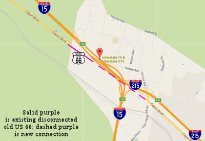 In October 2015, it was reported that an interchange
project at I-15 and I-215 that will reconnect old Route 66 in San
Bernardino County is ahead of schedule for its projected completion of
mid-2016. This will result in about two miles of old Route 66 in the Cajon
Pass being reopened to traffic for the first time in decades. Commuters
driving on Route 66 near the interchange will no longer face a gap in the
historic roadway from Kenwood Avenue to Devore Road. Motorists should find
less congestion along the old Route 66. Caltrans isn’t reconnecting
old Route 66 entirely out of the good of its heart. The road will serve as
an alternate route for when the freeway is closed because of an accident.
In October 2015, it was reported that an interchange
project at I-15 and I-215 that will reconnect old Route 66 in San
Bernardino County is ahead of schedule for its projected completion of
mid-2016. This will result in about two miles of old Route 66 in the Cajon
Pass being reopened to traffic for the first time in decades. Commuters
driving on Route 66 near the interchange will no longer face a gap in the
historic roadway from Kenwood Avenue to Devore Road. Motorists should find
less congestion along the old Route 66. Caltrans isn’t reconnecting
old Route 66 entirely out of the good of its heart. The road will serve as
an alternate route for when the freeway is closed because of an accident.
(Source: Route 66 News, 10/17/2015)
In San Bernardino, US 66 left US 91 and US 395 (now I-215) and headed west along the present day Route 66 along 5th Street and Foothill Blvd. This was LRN 9. In terms of freeways, this route has been bypassed by I-10. This section was defined in 1909. The history of the route in the Cajon Pass is discussed under I-15.
See the Gribblenation Blog at Cajon Pass; Cajon Pass Toll Road, National Old Trails Road, US Route 66/91/395 and Interstate 15 for detailed maps of the various routings of the highways that would become both I-15 and Route 138 in the Cajon Pass.
Route 66 currently terminates near the Foothill Freeway, I-210 (by 1963, LRN 240, duplicated by LRN 9). The original US 66 routing continued westward along Foothill, Alosta, Foothill (starting up again W of Glendora), Huntington, and Colorado Blvds. (LRN 9 along Foothill, and LRN 161 along Huntington). LRN 9 was defined in 1909. LRN 161 was defined in 1933, and LRN 240 was defined in 1959. After LRN 161 was defined, the parallel portion of LRN 9 was used for Route 118.
Note that there are true US 66 signs in Rialto, Rancho Cucamonga, and San Bernardino; specifically at the intersections with Mt. Vernon Avenue, Riverside Avenue, Citrus Avenue, Cherry Avenue, Etiwanda Avenue, Haven Avenue, and Archibald Avenue.
Much of the historical information on US 66 in Pasadena, Los Angeles, and Santa Monica was sourced from Jim Powell of the Route 66 Association in Missouri, as well as updates from the Gribblenation Blog (Tom Fearer), "The Arroyo Seco Parkway and early terminus points of US Route 66 in Los Angeles", January and September 2022; Jim Ross on FB, September 2022:
Pasadena
In June 2017, there was an article on an unusual
concrete highway marker on former US 66, at Colorado and Holliston Streets
in Pasadena. The marker is a 3-foot tall concrete tablet that looks like a
tombstone. On the face of the concrete tablet is the number 11 with a
circle around it, the numbers 220 and 200, and the letters “F”
and “B.” The marker is the only remant of a county house
addressing system proposed by Albert Bancroft. Implementation of the
system included concrete milestones, which identified the name of the road
and the distance from the county courthouse, which was the starting point
for the numbering system. By 1908, work was completed on six major
thoroughfares, including Foothill Boulevard. So the number 11 with a
circle around it tells us that we are 11 miles from the old county
courthouse – today the site of the Foltz Criminal Court Building in
downtown L.A. The “F” and the “B?” They tell us
that we are on the old Foothill Boulevard Route. And the 220 and 200 tell
us the block numbers.
(Source: Hidden History of LA, 6/8/2017)
As noted, the original routing of US 66 through Pasadena was part of LRN 9, which was defined in 1909 as one of the very early state highways in California resulting from the first State Highway Bond Act, for $18,000,000, issued in 1909 to establish a State Highway system. See below for the discussion of the original terminus in San Fernando.
Prior to 1933, routing and signage in the cities was up
to the Auto Club of Southern California. The earliest ACSC records show
the alignment of the National Old Trails Road (predecessor of US 66)
traveling westward from Pasadena on the following route until 1929:
(Source: Gribblenation Blog (Tom Fearer), "The Arroyo Seco Parkway and early terminus points of US Route 66 in Los Angeles", January 2022)
The routing of LRN 9 (National Old Trails Road (NOTR)) through Pasadena was: right on Shamrock Ave. in Monrovia, left on Foothill Blvd. through Arcadia into Pasadena, left on Santa Anita Ave. right on Colorado Street and left on Fair Oaks Ave.
In 1929 there was a shift of the alignment of US 101 in
downtown Los Angeles off of 2nd Street at Figueroa
Street. US 101 was routed southwest on Figueroa Street to 7th
Street, US 101 subsequently took 7th Street over the Los
Angeles River. This move to 7th Street shifted US 66
southward to a new terminus on Broadway at 7th Street.
(Source: Gribblenation Blog (Tom Fearer), "The Arroyo Seco Parkway and early terminus points of US Route 66 in Los Angeles", January 2022)
In December of 1930, the City of Los Angeles (working
with the City of Santa Monica to extend US 66 to the coast) selected a
route through L.A. that began at their boundary with Pasadena on Colorado
Blvd. then to Eagle Rock Blvd. and from there to Fletcher Ave., Glendale
Blvd., Rowena Ave., Hyperion Ave., Fountain Ave., and Myra Ave. to Santa
Monica Blvd. and then on to Santa Monica. Markers went up in January 1931,
but without approval of the state highway department or AASHO, and
apparently without the consent of Pasadena officials, who had already
selected Ave. 64 in their city for US 66 leading to Los Angeles (i.e., Ave
64 to York to Figueroa, then S to Los Angeles via Figueroa, Riverside,
Figueroa, Solano, and Broadway). Not surprisingly, the unauthorized
markers were ordered removed by the state engineer only four months later
from what has become known as the “rogue” route.
(Source: Jim Ross on FB, 9/27/2022)
California researcher Ian Bowen has done an exhaustive
study on the possible Eagle Rock/Fletcher alignment. Included in his
findings are documents suggesting that the US 66 terminus subsequent to
the rogue route debacle became US 101 (Sunset Blvd.) via Eagle
Rock/Fletcher, and remained so until 1935. According to a letter from the
state engineer in April 1931, removing the signs from the City of Santa
Monica back to US 101 (Sunset) would fulfill AASHO’s route
definition that the terminus be in Los Angeles. It is not known if this
was acted upon or approved, and another document from November 1931
identifies the terminus as Fletcher and San Fernando Road (US 99, LRN 4).
Supporting both possibilities is a photo of a US 66 marker at Fletcher and
San Fernando Rd. dated 1932, although it is possible there was an error in
the photo’s date or that the sign was related to the temporary
construction route along Eagle Rock during the same timeframe. Regardless
of which scenario one may favor, what is conspicuously missing are highway
maps from 1931-1935 depicting the Eagle Rock/Fletcher route as mainline US 66.
(Source: Jim Ross on FB, 9/27/2022)
Before the construction of the Pasadena Freeway, and
after completion of the Figueroa Tunnels, US 66 ran S along Figueroa (LRN 165, defined in 1933) to US 101 (LRN 2). Once the freeway was completed,
the prior routing was resigned as Alternate US 66, and US 66 was resigned
to run S on Fair Oak to pick up the freeway, and then S on the Pasadena
Freeway (Route 11, cosigned in portions with US 6, LRN 205, defined in
1935) to US 101. Note: Until 1935, the western terminus of US 66 was on
Broadway Street in downtown Los Angeles at 7th Street which
carried US 101 at the time. The very early state maintained alignment of
US 66 and US 101 can be seen on the 1935 California Division of Highways
map of Los Angles County. In October 1935, CHPW reported that US 66 had
been rerouted from a terminus at Sunset Blvd and Broadway in Los Angeles
to end in Santa Monica via Sunset and Santa Monica Blvd. Note that there
were a variety of end-points for US 66 during the 1930s.
(Sources: Various, Gribblenation Route 66)
The ACSC signed alignment of US 66 shifted in 1931 and
was reportedly in use until some point in 1934, reflecting the National
Old Trails Road alignment (the originally plan for US 60, later renumbered
US 66). The 1931 alignment of US 66 from Pasadena westward to Los
Angeles was as follows:
(Source: Gribblenation Blog (Tom Fearer), "The Arroyo Seco Parkway and early terminus points of US Route 66 in Los Angeles", January 2022)
There were attempts to reroute this highway from this original routing, due to a road jog in Arcadia. In a letter dated January 29, 1932, from Wm. Dunkerley, Secretary and Manager of the Pasadena Chamber of Commerce & Civic Association, to W.C. Markham, Executive Secretary of AASHTO, there is the statement: We have made request upon the State Highway Engineer at Sacramento for a rerouting of US 66 into Pasadena from Arcadia in order that a road jog in this highway might be avoided.
Markham replied on February 4, 1932, as follows: I have your letter of January 29th, in reference to re-routing U.S. 66 into Pasadena from Arcadia. I do not know what reference is made by the State Highway Engineer of your State in reference to a ruling we have made that would not permit your request being approved. Your letter gives so little information that I am not able to judge what the controversy is.
On March 9, 1932, Dunkerley responded to Markham as follows: Replying to your most recent inquiry, what we are most interested in is to provide the most convenient and easily accessible route into and through Pasadena. The enclosed map, while but a sketch, will explain what we have in mind. The route in red indicates the present routing of US 66 into and through Pasadena [The routing shown as north on Santa Anita in Arcadia, west on Foothill Blvd, south on Santa Anita in Pasadena and west on Colorado Street]; the blue indicates what we consider the most practical and convenient. [This route was straight through on Huntington Drive into Colorado Street.] We would like to know whether or not this can be accomplished. The State Highway Engineer has advised us that it is not within his power owing to a rule of your Association.
On March 15, 1932, Markham wrote the following to Dunkerley: I wish to acknowledge receipt of your letter of March 9th, in reference to your proposed rerouting of US 66 through the City of Pasadena. I wish to say that as far as the routing of a U.S. Number through a city is concerned that is a detail to be worked out entirely by the State Highway Department of the State involved.
On August 21, 1933, pursuant to a letter and resolution dated August 16, 1933, the California Legislature, in accordance with Section 363r of the Political Code, Chapter 326, approved LRN 161 in Los Angeles County. LRN 161 was 17 miles in length, and described as: "State Highway Route 4 [LRN 4] near Glendale to State Highway Route 9 [LRN 9] near Monrovia. This connection carries from the San Fernando Road northwest approach to Los Angeles due easterly to the Foothill Boulevard, passing through and serving large communities on direct routing. The western terminus is on Southern Pacific shipping and passenger point, and at a point correlated with continuous routings to the Ventura Boulevard and to Santa Monica that will facilitate such movement. The route affects intercounty traffic as well as local.". This says the highway is from San Fernando Road (US 99) in Glendale to Shamrock Ave. in Monrovia along Colorado Blvd./Street into Huntington Drive. This road was signed as Sign Route 134, and the parallel portion of LRN 9 on Foothill Blvd. was signed as Sign Route 118. Colorado Street in Pasadena was also dual signed as US 66 at this time.
Additional information on all the various routings and
reroutings of US 66 in Pasadena into Downtown Los Angeles are detailed in
the Gibblenation Blog The Arroyo Seco Parkway and early terminus points of US Route 66 in Los Angeles. There were at least three alignments of US 66 between
Colorado Blvd and US 101 before the Arroyo Seco Parkway came into play.
The Gribblenation Blog gives the specifics. These included routings along
Eagle Rock Blvd and Temporary LRN 165 on Avenue 64 and York Blvd.
(Colorado to Avenue 64 to York to Figueroa to Riverside Drive to Figueroa
to Solano to Broadway, which moved to all Figueroa once the tunnels were
completed).
(Source: Gribblenation Blog (Tom Fearer), "The Arroyo Seco Parkway and early terminus points of US Route 66 in Los Angeles", January 2022)
After 1933, the state could maintain routes in the
city, leading to the creation of LRN 165. Much of the early US Route system around Los Angeles was heavily altered at this point.
Sometime between late 1934/early 1935 the route of US 101 was realigned
through downtown Los Angeles via Sunset Boulevard and Macy Street.
This in turn truncated US 66 from Broadway/7th Street to
Broadway, and later Figueroa at Sunset Boulevard (US 101). During
1934, US 99 was realigned off a multiplex of US 66 from Pasadena-San
Bernardino (LRN 9) to a new alignment which took it to Redlands via
downtown Los Angeles, Pomona and Colton (LRN 26).
(Source: Gribblenation Blog (Tom Fearer), "The Arroyo Seco Parkway and early terminus points of US Route 66 in Los Angeles", January 2022)
By 1935 the process was started to extend US 66 to US 101A in Santa Monica via what was Route 2. This became official in
January 1936. Another change happened in July 1936 when the fourth
Figueroa Street Tunnel opened to traffic. This changed where US 66 met US 101 to Figueroa and Sunset. US 66 now continued through the tunnel to meet
US 101 downtown. By 1938, US 6 (extended to California in 1937)
multiplexed US 99/LRN 4 on San Fernando Road, where the two routes joined
US 66/Route 11/LRN 165 through the Figueroa Street Tunnels. By 1943,
US 66 was shifted onto the Arroyo Seco Parkway entirely whereas Sign Route 11 joined it with US 6/US 99 via San Fernando Road.
(Source: Gribblenation Blog (Tom Fearer), "The Arroyo Seco Parkway and early terminus points of US Route 66 in Los Angeles", January 2022)
At the eastern edge of Pasadena, US 66 ran along Colorado Blvd (LRN 161), with the I-210 Freeway routing along LRN 240. Scott Parker at AAroads noted that there was an Alternate US 66 along Colorado Blvd. west of Fair Oaks Ave (LRN 9 turned north and NW along Sign Route 118) west to Figueroa St., where Alternate US 66 (along with Sign Route 11, which joined Alt. US 66 from Linda Vista Ave. south of the Rose Bowl) turned south (the whole of Sign Route 11 was LRN 165). LRN 161 continued west through Glendale and Burbank, signed as Route 134, originally terminating at US 101/LRN 2 in Sherman Oaks but cut back to Lankershim Blvd. (LRN 159) in North Hollywood circa 1957. The purpose of the 2nd section of LRN 161 was simply to straighten out the alignment of US 66 in the Pasadena/Arcadia area.
In 1940, US 66 was rerouted onto the new Arroyo Seco
Parkway, and the older route on Figueroa Street was co-signed with Route 11 as US 66 Alternate. This made US 66A the designation across the
Colorado Street Bridge west of downtown Pasadena. US 66 was truncated to
Needles in 1963, removing the official US 66 designation from Route 11
(although signs likely remained), and getting rid of US 66A. The 1964
renumbering created Route 248 to sign the underlying state highway across
Colorado, and US 66 remained signed to Monrovia although the route was
Route 248.
(Source: Gribblenation Blog (Tom Fearer), "Former California State Route 248 (Old US Routes 66-99 from Pasadena to Monrovia)", 10/2022)
In 1964, the former US 66 routing along the Colorado
Street Bridge, Colorado Boulevard, Colorado Place, and Huntington
Boulevard became Route 248, although it was signed as US 66 (Route 248 was
a placeholder for the dying US 66). In the Pasadena area, signage of US 66
would be truncated from Pasadena to US 95 when I-40 was completed through
the Bristol Mountains in 1972. At that point, portions of Route 248
became signed as (California) Route 66.
(Source: Gribblenation Blog (Tom Fearer), "Former California State Route 248 (Old US Routes 66-99 from Pasadena to Monrovia)", 10/2022)
In 1986, Chapter 928 truncated Route 248 out of
Pasadena: “Route 134 near the east limit of the
City of Pasadena to Route 210 near Monrovia.” This left
Route 248 as starting just W of Rosemead Blvd, Route 164. Field signage at
this time is unknown. In 1992, the remainder of Route 248 was deleted by
AB 3090, Chapter 1243.
Arroyo Seco Parkway
On September 7, 1940, Purcell (Dept. of Highways) wrote Markham (AASHTO) as follows:
Pursuant to the Purpose and Policy of the American Association of State Highway Officials in the establishment of US Numbered Highways, we hereby make formal application to change the route of US 66 between Pasadena and Los Angeles, from Colorado and Figueroa Streets to the Arroyo Seco Parkway, and to designate the existing route between these points as US 66 ALTERNATE.
The proposed new route, which is expected to be opened to traffic next New Year's Day, shortens the distance by approximately 2.35 miles, and affords travel a new freeway consisting of a six lane divided highway.
As the motoring public will be better served by using this new thoroughfare, permission is requested to place US 66 ALTERNATE markers on the present routing [From Colorado Street and Broadway In Pasadena, easterly along Colorado Street to Figueroa Street thence southerly along Figueroa Street to the Arroyo Seco Parkway in Los Angeles], and to erect US 66 signs on the Arroyo Seco Parkway."
On October 9, 1940, Markham replied to Purcell as follows:
We have your letter of September 7 in reference to re-routing locally U.S. 66 between Pasadena and Los Angeles.
In view of the fact that the slight change you proposed to make in this routing does not involve any key points in the description, it will not be necessary to file this request with the Committee. It might be well, however, for us to notify the map makers as to when it will go into effect, in case they give a local enlargement of the routing in metropolitan Los Angeles.
San Fernando
LRN 9 was defined in 1909 as one of the very early state highways in California resulting from the first State Highway Bond Act, for $18,000,000, issued in 1909 to establish a State Highway system. It had a routing of "San Fernando to San Bernardino".
It appears that the original intent was to have the
highway continue along LRN 9 and terminate in San Fernando, where the
route would meet US 99. This is based on a letter dated March 1, 1927,
from California State Highway Engineer R.M. Morton replied to AASHO
Executive Secretary W.C. Markham conveying it was the understanding of the
state that US 66 ended in San Fernando. The description of US 99
would have it jog south into Los Angeles and then follow a multiplex of US 66 east to San Bernardino.
(Source: Gribblenation Blog (Tom Fearer), "The Arroyo Seco Parkway and early terminus points of US Route 66 in Los Angeles", January 2022)
On April 26, 1927, W.C. Markham wrote in a letter to
California Highway Commission Office Engineer L.T. Cambell stating it
would be preferable to have US 66 end somewhere in Los Angeles. W.C.
Markham noted US 66 was already being promoted as the primary highway in
the Chicago-Los Angeles Corridor. W.C. Markham goes onto suggest
that it would be helpful if signage of the western terminus of US 66 was
placed in the nearest convenient location within the City of Los
Angeles. The terminus of US 66 in San Fernando is described
as a technical error and that the last City on the Route Description
should be Los Angeles.
(Source: Gribblenation Blog (Tom Fearer), "The Arroyo Seco Parkway and early terminus points of US Route 66 in Los Angeles", January 2022)
By 1928, US 66 was stated in the January 1928
California Highways & Public Works as terminating in Los Angeles via
San Fernando. This implied that US 66 was to be signed somewhere via
multiplex of US 99 on San Fernando Road into the City Limits of Los
Angeles. However prior to 1933, the Division of Highways was not
actively involved in maintaining urban highways outside of occasional
cooperative projects, and the responsibility for signage of US Routes in
cities was given to the Automobile Club of Southern California (ACSC) in
the Southern California region. They were free to sign as they please,
adding to the confusion.
(Source: Gribblenation Blog (Tom Fearer), "The Arroyo Seco Parkway and early terminus points of US Route 66 in Los Angeles", January 2022)
According to the California Historic Route 66
Association pre-1932 ACSC records indicate that the routing of early US 66
was concurrent with that of the National Old Trails Road (NOTR) between
Pasadena and Los Angeles. In April of 1912 the NOTR was organized with the
goal of signing a trans-continental highway between Baltimore and Los
Angeles. For this discussion, the relevant portion is the portion between
San Bernardino and Los Angeles. From San Bernardino beginning at Mount
Vernon Avenue/4th Street the NOTR followed existing LRN 9
westbound to Pasadena. Upon reaching Pasadena the NOTR branched away
from LRN 9. The NOTR westbound jogged south on Santa Anita Avenue to
Colorado Boulevard in Pasadena and departed towards Los Angeles via Fair
Oaks Avenue. The NOTR followed Fair Oaks Avenue, Huntington Drive
and Broadway into downtown Los Angeles where it terminated at the
intersection of 7th Street and Broadway. This is the origin of
the 7th Street and Broadway terminus for US 66. The initial
draft of the US Route System approved by the Secretary of Agriculture in
November 1925 showed planned US 60 (later renumbered as US 66) as
following the NOTR from the Arizona State Line to a terminus in Los
Angeles.
(Source: Gribblenation Blog (Tom Fearer), "The Arroyo Seco Parkway and early terminus points of US Route 66 in Los Angeles", September 2022)
Los Angeles / Santa Monica Terminus
ACSC originally signed US 66 to terminate at Broadway and US 101 at 2nd Street in downtown Los Angeles. This was independent of the Department of Highways, which had the terminus in San Fernando. So even though the DOH though the terminus was San Fernando in 1929, the ACSC seemingly signed it in Los Angeles. By 1931, a shift in the alignment of US 101 changed the ACSC-signed terminus to US 101 at 7th Street.
Even as early as 1931, there was a push by the City of
Santa Monica to get the route to terminate in Santa Monica. Santa Monica
did about everything it possibly could to get US 66 extended into its
boundaries. These attempts went as far as funding the Auto Club of
Southern California to sign US 66 through Los Angeles all the way to Ocean
Avenue via Santa Monica Boulevard from December 1930-January 1931.
(Source: Gribblenation Blog (Tom Fearer), "The bizarre history of the western terminus of US Route 66 in Santa Monica", October 2022)
AASHO minutes show a route in flux. An exchange of
letters dated to November/December 1931 between C.H. Purcell the
California State Highway Engineer and W.C. Markham Executive Secretary of
the AASHO indicated that the DOH wanted to split US 66 into a mainline
routing terminating at US 101 in downtown Los Angeles and an Alternate
Route which bypassed downtown towards US 101 at Sunset
Boulevard. AASHO recommended extending US 66 to Santa Monica
so that they Mainline and Alternate Route would have a meet up point via
US 101. Ultimately the Division of Highways did not want US 66 ending in
Santa Monica whereas the AASHO didn't want dual terminus points. But
key to these documents is that they show the terminus point for US 66
ending at US 99/San Fernando Road via Fletcher Drive (very different than
the ACSC signage). The route to Fletcher was likely Colorado Blvd in
Pasadena to Eagle Rock Blvd.
(Source: Gribblenation Blog (Tom Fearer), "The Arroyo Seco Parkway and early terminus points of US Route 66 in Los Angeles", January 2022)
The AASHTO Database file for 1931 also shows a letter
dated April 7, 1931 that states that there was rogue signage placed by the
ACSC extending US 66 to Santa Monica. C.H. Purcell states in a
response letter that this signage was not officially approved by the AASHO
and had been placed by the ACSC at the behest of the City of Los Angeles
and Los Angeles County. Notably the despite the ACSC committing to
remove US 66 signage in the Los Angeles-Santa Monica corridor it is not
fully clear if they actually ever did. A photo from Santa Monica
Boulevard looking east from Pandora Avenue on January 31, 1935, shows
Route 2 shields instead of US 66. The Sign State Routes had been
announced the previous August which included Sign Route 2. City Council
minutes from the time (1931) indicate that the ACSC signage of US 66
within the City of Los Angeles began on Colorado Boulevard at the Los
Angeles/Pasadena City Lines. US 66 followed Colorado Boulevard,
Eagle Rock Boulevard (formerly Glassell Avenue), and Fletcher Drive to US 99 at San Fernando Road. US 66 continued westward via Glendale
Boulevard, Rowana Boulevard, Hyperion Avenue, Myra Avenue and its viaduct
under Sunset Boulevard, and Santa Monica Boulevard to the City of Santa
Monica. The signage of US 66 to Santa Monica was requested by the
Santa Monica-Ocean Park Chamber of Commerce at their own expense.
The Los Angeles City Council approved the request to extend Santa Monica
on December 15, 1930.
(Source: Gribblenation Blog (Tom Fearer), "The Arroyo Seco Parkway and early terminus points of US Route 66 in Los Angeles", January 2022)
In an update to his Gribblenation Blog "The Arroyo Seco Parkway and early terminus points of US Route 66 in Los Angeles" in February 2022, Tom Fearer summarized the pre-1935 changes to the route in Los Angeles as follows:
(Source: FB introduction to Gribblenation Blog updates; Gribblenation Blog "The Arroyo Seco Parkway and early terminus points of US Route 66
in Los Angeles", February 2022)
Santa Monica
Santa Monica longed pushed to have the western end of
US 66 be located in Santa Monica. As early as 1928, Santa Monica was
planning to send delegates to the June 6, 1928, US Route 66 Association
convention Flagstaff in an attempt to secure the western terminus of the
highway. In 1929, it was reported that Los Angeles intended to aid the
city of Santa Monica in signing US 66 to their boundaries. The Los
Angeles city engineer John C. Shaw was directed by the Los Angeles City
Council to cooperate with extending US 66 to Santa Monica. US 66 is
noted in the article to be currently signed to the western terminus at the
Los Angeles/Pasadena city limit at the western edge of the Colorado Street
Bridge. A planned routing for US 66 through Los Angeles to Santa
Monica is described as following Pasadena Avenue, York Boulevard, Eagle
Rock Boulevard, Fletcher Drive, Glendale Boulevard, Rowena Avenue,
Hyperion Avenue, Fountain Avenue, and Myra Avenue. However, that
doesn't work on either end, as Pasadena Avenue does not connect to York
Blvd (likely, they meant Ave 64), and on the other end, Myra connects to
Santa Monica Blvd. No planned terminus for US 66 in Santa Monica was
cited.
(Source: Gribblenation Blog (Tom Fearer), "The bizarre history of the western terminus of US Route 66 in Santa Monica", October 2022)
As of 1930, US Routes were not yet signed within Los
Angeles. The Los Angeles City Council voted to have the ACSC sign US 99 and US 101 during the February 5, 1930, meeting but not US 66.
The rationale by the Los Angeles City Council for not having the ACSC sign
US 66 was due to the uncertainty of the location of the highway. In
1930 the City of Santa Monica petitioned the Los Angeles City Council to
have the ACSC sign US 66 through Los Angeles to their city limit at their
expense. The Los Angeles City Council approved the request to allow
the ACSC to sign US 66 to Santa Monica on December 15, 1930. The Los
Angeles City Council notably did not petition the California Highway
Commission or AASHO regarding the signing of US 66 to Santa Monica.
The ACSC signage began on Colorado Boulevard at the Los Angeles/Pasadena
City Lines. US 66 followed Colorado Boulevard, Eagle Rock Boulevard
(formerly Glassell Avenue), and Fletcher Drive to US 99 at San Fernando
Road. US 66 continued westward via Glendale Boulevard, Rowana
Boulevard, Hyperion Avenue, Myra Avenue and its viaduct under Sunset
Boulevard, and Santa Monica Boulevard to the city of Santa Monica.
(Source: Gribblenation Blog (Tom Fearer), "The bizarre history of the western terminus of US Route 66 in Santa Monica", October 2022)
The AASHTO Database file for 1931 shows a letter dated
April 7th that illustrates the California Highway Commission
and AASHO had become aware of US 66 being signed through Los Angeles to
Santa Monica. California State Highway Engineer C.H. Purcell
acknowledges in a response letter to the AASHO Executive Secretary that
the US 66 signage in Santa Monica was not officially approved by the AASHO
and had been placed by the ACSC at the behest of the City of Los Angeles
and Los Angeles County. C.H. Purcell notes the ACSC had agreed to
withdraw US 66 signage from the city limit of Santa Monica. No
officially established western terminus of US 66 is discussed in the
exchange of letters. The signage was removed at the end of May 1931.
(Source: Gribblenation Blog (Tom Fearer), "The bizarre history of the western terminus of US Route 66 in Santa Monica", October 2022)
In an exchange of letters at the end of 1931 between
C.H. Purcell (the California State Highway Engineer) and W.C. Markham
(Executive Secretary of AASHO), Markham conveys a desire to split US 66 into a mainline routing terminating at US 101 in downtown Los Angeles
at Sunset Boulevard via Broadway and an Alternate Route which bypassed
downtown towards US 101 at Sunset Boulevard via Hyperion
Avenue. AASHO recommended extending US 66 to Santa Monica so
that the Mainline and Alternate Route would have a meet-up point via US 101. But this notion didn't fly.
(Source: Gribblenation Blog (Tom Fearer), "The bizarre history of the western terminus of US Route 66 in Santa Monica", October 2022)
On June 14th, 1935, the California State
Highway Engineer submitted a request to extend US 66 from the intersection
of Broadway and Sunset Boulevard in Los Angeles to the intersection of
Lincoln Boulevard and Pennsylvania Avenue in Santa Monica. Pennsylvania
would later become Olympic Blvd, and reflects the end of the McClure
Tunnel.
(Source: Gribblenation Blog (Tom Fearer), "The bizarre history of the western terminus of US Route 66 in Santa Monica", October 2022)
On June 17, 1935, the AASHTO minutes simply state that: "US 66 was extended from Los Angeles to Santa Monica." The effective date of the change was January 1, 1936. As for the end in Santa Monica: on June 14, 1935, Purcell wrote Markham as follows: There are attached eighteen copies of detailed description with sketches showing proposed routing of Extension of US Highway № 66 from Los Angeles to Santa Monica. Annoucement of the extension was to be delayed until the extension of US 6 to long beach was completed.
This extension as shown in description is recommended for approval.
Here's the description, as submitted:
PROPOSED EXTENSION OF US 66 DISTRICT 711 TO SANTA MONICA
Beginning at the intersection of North Broadway and Sunset Boulevard, the junction of US 66, US 99, and US 101, in the City of Los Angeles; thence, northwesterly over Sunset Boulevard (State Highway Route 2) and US 101 to Santa Monica Boulevard; thence, westerly over Santa Monica Boulevard (a city street) to Myra Avenue, the junction of State Highway 162 [LRN 162] and Sign Route (2) [Route 2]; thence, continuing westerly over Santa Monica Boulevard (State Highway Route 162 [LRN 162]) and Sign Route (2) [Route 2] through the Cities of Los Angeles and Beverly Hills to the intersection of Santa Monica Boulevard and Lincoln Boulevard, in the City of Santa Monica; thence, southerly along Lincoln Boulevard to the terminus at Pennsylvania Avenue, a total distance of approximately 13.00 miles.
Note for the above: US 99 was actually not at North Broadway and Sunset, but at Ave 26/San Fernando Road and Figueroa.
Remember, in 1935, Olympic Boulevard had been approved as LRN 173, but had not been constructed. This road was later marked as Route 26. If, however one was to draw a line from Pennsylvania Ave. to the junction of LRN 162 (Route 2 and US 66) with LRN 60 (Route 1 and US 101A) at Lincoln Blvd., the points would match. The highway department obviously used Pennsylvania Ave. as the point of reference since Olympic Blvd. did not yet exist.
 In the announcement of the formal extension of US 66 in the July 2, 1935,
Santa Monica Outlook, the article notes US 66 was to be extended back to
Ocean Avenue via Santa Monica Boulevard to an interim terminus. The
article notes the change of Sign Route 3 on Roosevelt Highway to US 101A
as being critical in making the extension of US 66 to Santa Monica
official. The interim terminus of US 66 via LRN 162 to Ocean Avenue
in Santa Monica was necessary due to the incomplete new tunnel alignment
(McClure Tunnel) that carry US 101A/LRN 60 through Palisades Bluff.
The extension of US 66 to Santa Monica truncated Route 2 to Hyperion
Avenue along LRN 162. The opening of the Santa Monica Tunnel
(McClure Tunnel) and realignment of US 101A/LRN 60 rendered the interim
alignment of US 66 at Ocean Avenue via Santa Monica Boulevard
obsolete. The terminus of US 66 then followed LRN 162 to US 101A/LRN 60 at the intersection of Lincoln Boulevard and Olympic Boulevard.
In the announcement of the formal extension of US 66 in the July 2, 1935,
Santa Monica Outlook, the article notes US 66 was to be extended back to
Ocean Avenue via Santa Monica Boulevard to an interim terminus. The
article notes the change of Sign Route 3 on Roosevelt Highway to US 101A
as being critical in making the extension of US 66 to Santa Monica
official. The interim terminus of US 66 via LRN 162 to Ocean Avenue
in Santa Monica was necessary due to the incomplete new tunnel alignment
(McClure Tunnel) that carry US 101A/LRN 60 through Palisades Bluff.
The extension of US 66 to Santa Monica truncated Route 2 to Hyperion
Avenue along LRN 162. The opening of the Santa Monica Tunnel
(McClure Tunnel) and realignment of US 101A/LRN 60 rendered the interim
alignment of US 66 at Ocean Avenue via Santa Monica Boulevard
obsolete. The terminus of US 66 then followed LRN 162 to US 101A/LRN 60 at the intersection of Lincoln Boulevard and Olympic Boulevard.
(Source: Gribblenation Blog (Tom Fearer), "The bizarre history of the western terminus of US Route 66 in Santa Monica", October 2022; Image source: US Ends.Com)
By 1936, US 66 then ran NW on US 101 (LRN 2, defined in 1909) to Santa Monica Blvd. At Santa Monica, US 66 exited and continued W to Santa Monica. In 1936, it terminated at Lincoln and Olympic. There is a plaque at the Palisades Bluffs at Ocean Avenue where Santa Monica Blvd meets Ocean commemorationg the end of US 66, the "Will Rogers Highway", "Main Street of the USA", but this was only the interim terminus while the McClure tunnel was reconfigured.
 Alternate Routes
 In February 1956, the States of Nevada, California, and Arizona submitted a request to the
AASHO to establish US 66A (Alternate) to Las Vegas. The proposed US 66A would have originated from mainline US 66 in Kingman Arizona and
followed a multiplex of US 93/US 466 to Las Vegas, Nevada.
From Las Vegas, Nevada, the proposed US 66A would have multiplexed US 91/US 466 back to mainline US 66 in Barstow, California. The request
to establish US 66A was denied during June 1956 due to it being completely
multiplexed with other US Routes.
In February 1956, the States of Nevada, California, and Arizona submitted a request to the
AASHO to establish US 66A (Alternate) to Las Vegas. The proposed US 66A would have originated from mainline US 66 in Kingman Arizona and
followed a multiplex of US 93/US 466 to Las Vegas, Nevada.
From Las Vegas, Nevada, the proposed US 66A would have multiplexed US 91/US 466 back to mainline US 66 in Barstow, California. The request
to establish US 66A was denied during June 1956 due to it being completely
multiplexed with other US Routes.
(Source: Gribblenation Blog (Tom Fearer), "Paper Highways: Proposed US Route 66 Alternate to Las Vegas, Nevada", July 2022)
In November 1955, it was reported that during improvements to Cajon Pass,
LRN 191 was signed as US 66 Alternate (in reality US 66 Business).
The US 66 Business Loop followed LRN 191 on Kendall Drive and E Street to
Highland Avenue. From Highland Avenue the US 66 Business Loop
followed Route 18 via E Street and 5th Street back to mainline
US 66 through downtown San Bernardino. The original US 66 Business
Loop in San Bernardino is unique in that it was chosen to follow an
alignment which never part of mainline US 66. A 1951 article noted
that the I Street Overhead was to carry Route 18 and US 66 Business via
LRN 9 over what had been previous an at-grade crossing of the Atchison,
Topeka & Santa Fe Railway (ATSF) mainline through San
Bernardino. Prior to the opening of the I Street Overhead, both
Route 18 and US 66 Alternate were aligned on 3rd Street.
(Source: Gribblenation Blog (Tom Fearer), "Former California State Route 206 and the original US Route 66 Business Loop in San Bernardino", July 2022)
The US 66 Alternate routing may go back to the 1940s. The 1942 USGS Map
of San Bernardino displays Route 18 and US 66 Alternate on 3rd
Street between E Street and Mount Vernon Avenue. US 66 Alternate
would have connected with mainline US 66 at 4th Street via
Mount Vernon Avenue. It appears this signage of the alternate routing was
done either by the Division of Highways or by San Bernardino; it was not
approved by AASHO.
(Source: Gribblenation Blog (Tom Fearer), "Former California State Route 206 and the original US Route 66 Business Loop in San Bernardino", July 2022)
 Business Routes
There were two Business US 66 alignments that were approved: one on the Figueroa Street alignment in Los Angeles and a second following what became Route 206 in San Bernardino.
See the ALTERNATE discussion above for the original business loop in San
Bernardino, which may have been signed as "Alternate". In terms of formal
requests, the Division of Highways submitted a request on May 13, 1958, to
create a new US 66-US 91-US 395 Business Loop in San Bernardino due to the
construction of I-15. The new US 66 Business Loop followed Mount
Vernon Avenue and 5th Street in San Bernardino via the original
surface routing of the highway. The request by the Division of
Highways also sought to eliminate the existing US 66 Business Loop on LRN 191, Kendall Drive, E Street and 5th Street. The AASHO
approved the Division of Highways request on June 26, 1958, which
eliminated the US 66 Business Loop on LRN 191.
(Source: Gribblenation Blog (Tom Fearer), "Former California State Route 206 and the original US Route 66 Business Loop in San Bernardino", July 2022)
 Historical Route
 The portion of the current Route 66 (CA 66) in Los Angeles
County is unsigned. With respect to the former US 66 routing, some cities
are now using using the "Historic US 66" signage. Monrovia is an
exception; they are using an old-style cut-out U.S. highway shield (i.e.,
the shield that includes the state name). In Glendora, they have renamed
Alosta Avenue as Route 66.
The portion of the current Route 66 (CA 66) in Los Angeles
County is unsigned. With respect to the former US 66 routing, some cities
are now using using the "Historic US 66" signage. Monrovia is an
exception; they are using an old-style cut-out U.S. highway shield (i.e.,
the shield that includes the state name). In Glendora, they have renamed
Alosta Avenue as Route 66.
This route is part of "Historic Highway Route 66", designated by Assembly Concurrent Resolution 6, Chapter 52, in 1991.
 Status
In October 2016, the CTC authorized relinquishment of right of way in the city of San Bernardino along Route 215 from 2nd Street to 16th Street and on Route 66 (“H” Street) from 4th Street to 6th Street (08-SBd-215-PM 6.8/7.6, and 08-SBd-66-PM S23.16/S23.41), consisting of superseded highway and collateral facilities. The City, by freeway agreement dated January 21, 2003, agreed to accept title upon relinquishment by the State. The 90-day notice period expired August 29, 2016.
In April 2016, it was reported that Barstow, with the help from a committee made up of community stakeholders, is working on a
Downtown/Route 66 Specific Plan. The city hired a company called MIG to
help develop the plan, which is supposed to set a vision for growth and
revitalization along the city's historic Route 66 business corridor and
within the downtown business and cultural district. The plan includes
goals, policies, action strategies, development standards and design
guidelines with the goal of drawing more visitors to Barstow's segment of
Route 66. The plan addresses a lot of appearance issues and suggests
adding more color to the area. Signs and lighting are also addressed. The
draft plan, however, also involves investment by the city and California.
Directional and landmark signs play a major role. There are five proposed
locations for directional signs to downtown Barstow. There are three sign
locations along I-15 to notify motorists of upcoming off-ramps to the
Barstow Factory Outlets and downtown, a directional sign located on Route 58 prior to the Main Street exit and one directional sign location on I-40
to alert motorists of the Main Street exit. The city is also getting ready
to install eight automobile-themed signs down the Route 66 corridor. He
said each one will have certain classic cars on them. The draft plan also
suggests bringing back the neon signs to increase visibility for
businesses. The businesses are also encouraged to incorporate art into
signage.
(Source: Victorville Daily Press, 4/23/2016; Route66
News, 5/4/2016)
There may be a risk to the section of former US 66 near Amboy, due to potential expansion of the Marine Corps base in the 29 Palms area. In August of 2008, the
U.S. Marine Corps filed with the Bureau of Land Management for the
withdrawal of 422,000 acres contiguous with the Twentynine Palms base in
San Bernardino County. These lands were being considered for a possible
base expansion, and are a mixture of private property, wildlife reserves,
BLM lands and State recreation areas. The proposal for the eastern
expansion would extend northward to the southern edge of the National
Trails/Route 66 highway, on the alignment loop south of I-40, just east of
Bagdad and Amboy. The expansion, if executed, would remove the entirety of
Amboy Crater from public access. More information from the neighbors in
the area can be found at the Desert Neighbors Site. Later reports indicate that the current EIS seems to have abandoned expansion to the north in favor of expansion to the west
and a small piece to the south.
In March 2017, it was reported that San Bernardino County Public Works will be constructing two new bridges and road improvements on
National Trails Highway (Former US 66) at Dola Ditch (2.08 miles east of
Kelbaker Road) and Lanzit Ditch (2.77 miles east of Kelbaker Road), east
of the community of Amboy. The construction will include removing the
existing timber bridges and constructing new timber bridges. A portion of
National Trails Highway will be closed at all times to through traffic,
including emergency vehicles. Traffic will be routed around the
construction on public streets and highways. The detour plan includes
using I-40 and Kelbaker Road. Local residents and businesses will have
access from Essex Road west to the construction site, but there will be no
traffic through the construction site. Construction of the project is
tentatively scheduled to start in March 2017 and run through mid-September
2017. The release noted the replacement of two bridges is part of a
long-term plan to replace 127 bridges along the Former US 66 corridor in
the Mojave Desert. Many of the bridges are 80 to 90 years old and are
deemed functionally obsolete and structurally deficient. This is the
second extended closure of Former US 66 in the Mojave in recent years.
Flash flooding in September 2014 damaged dozens of bridges and the roadway
itself, forcing San Bernardino to close Former US 66 for months. It took
six months for the county to reopen just the 28-mile part of the road from
Ludlow to Amboy. To this day, a part of National Trails Highway from Exit
115 of I-40 to just east of Essex remains closed because of the damage.
Most Former US 66 travelers, however, go to Essex through Goffs Road and
the roadside town of Fenner.
(Source: Route 66 News, 3/2/2017)
 National Trails
 This route (both present-day Route 66 and as historic US 66) was part of the "Arrowhead Trail (Ocean to Ocean Trail)". It
was named by Resolution Chapter 369 in 1925.
This route (both present-day Route 66 and as historic US 66) was part of the "Arrowhead Trail (Ocean to Ocean Trail)". It
was named by Resolution Chapter 369 in 1925.
This route (both present-day Route 66 and as historic US 66) was
part of the "National Old Trails Road".
 This route (both present-day Route 66 and as historic US 66)
was part of the "Santa Fe Trail".
This route (both present-day Route 66 and as historic US 66)
was part of the "Santa Fe Trail".

 This route (both present-day Route 66 and as
historic US 66) appears to have been part of the "National Park to Park
Highway", and the "Pikes Peak Ocean to Ocean Highway".
This route (both present-day Route 66 and as
historic US 66) appears to have been part of the "National Park to Park
Highway", and the "Pikes Peak Ocean to Ocean Highway".
 Other WWW Links
 Statistics
Overall statistics for Route 66:
 Pre-1964 Legislative Route
The route that would become LRN 66 was first defined in 1921 by Chapter 845, which called for the transfer and conveyance to the state of “... that certain road situated in the county of San Joaquin ... to wit: Beginning at a point on the W boundary of the city of Manteca, and on the township line between T1S and T2S, R7E, Mt Diablo base and meridian, and running thence W on the township line to the W side of the Southern Pacific RR RoW to the state highway at the Mossdale School...” In 1933, the route was extended from [LRN 4] near Manteca to [LRN 13] near Oakdale. In 1935, it was captured into the state highway code as:
In 1961, Chapter 1146 combined the segments and changed the western end to Route 238 near Mossdale, making the definition "[LRN 238] near Mossdale to [LRN 13] near Oakdale via the vicinity of Manteca."
LRN 238 was the routing for the eventual freeway I-5 (Westside Alignment), and LRN 66 started a few miles E of Tracy (near the present I-205/I-5 junction). Before LRN 238 was defined, this route started at LRN 5, which was US 50. The route (LRN 66) ran to LRN 13, which was Route 108 (unsigned in 1934). LRN 66 was signed as Route 120 from the start of state signage in 1934.
© 1996-2020 Daniel P. Faigin.
Maintained by: Daniel P. Faigin
<webmaster@cahighways.org>.
 Route 65
 Route 67