
 California Highways:
Click here for a key to the symbols used. An explanation of acronyms may be found at the bottom of the page.
 Routing
 Post 1964 Signage History
This route remains as defined in 1963.
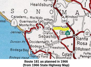
River Road, as now exists between Fulton (US 101 and Mark West
Springs Road) and Gurneville (Route 116) was built on top of an old SP
railroad right-of-way by Sonoma County in the late 1950's. This alignment
basically bypassed several secondary county roads such as Laughlin Road,
Woolsey Road, Trenton Road, and the what was then called "River Road". The
segment from US-101 to Mirabel Road was the proposed Route 181. At the
time the "new" River Road was constructed, it was proposed that Route 116
be rerouted away from its Pocket Canyon Road alignment between Forestville
and Guerneville, and routed down Mirabel Road to River Road, and then West
to Guerneville.
(Source: Email from Nick Karels of Santa Rosa)
 Pre 1964 Signage History
This was proposed LRN 250, defined in 1959.
Route 181 was not defined as part of the initial state signage of routes in 1934. It is unclear what (if any) route was signed as Route 181 between 1934 and 1964.
 Status
According to the 2013 Traversable Highways report, the closest routing is Mirable Road and River Road. Mirable from Route 116 to River Road does not meet State standards.
 Freeway
[SHC 253.1] Entire route; unconstructed. Added to the Freeway and Expressway system in 1959.
 Other WWW Links Status
The routing for Route 181 has not been determined; although there is a traversable local route: Mirable Road and River Road, with no plans for improvement to state standards.
 Statistics
Overall statistics for Route 181:
 Pre-1964 Legislative Route
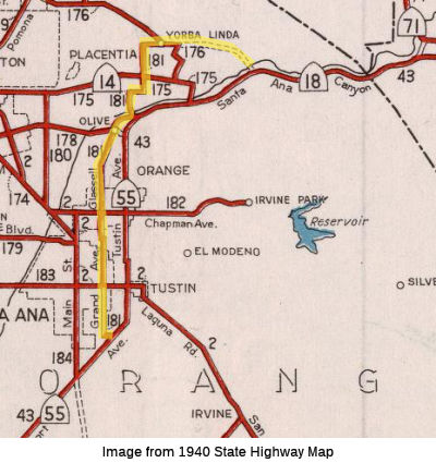 In 1933, the route from "[LRN 43] to La Habra-Santa Ana
Canyon Road near Yorba Linda via Grand Avenue and Glassell Avenue" was
defined as part of the state highway system. In 1935, it was added to the
highway code as LRN 181, with the routing:
In 1933, the route from "[LRN 43] to La Habra-Santa Ana
Canyon Road near Yorba Linda via Grand Avenue and Glassell Avenue" was
defined as part of the state highway system. In 1935, it was added to the
highway code as LRN 181, with the routing:
"[LRN 43] to [LRN 176] near Yorba Linda via Grand Avenue and Glassell Avenue"
Looking at the map, this would be the route starting at Route 55 (Harbor) from Dyer to Grand, up Grand (turning into Glassell) to Orange-Olive Ave turning onto Santa Ana Canyon. It then ran to Jefferson, and up Jefferson to Walnut, across Walnut to Richfield, and then up Richfield to Yorba Linda Blvd. It then ran along Yorba Linda to Imperial Highway, Route 90/LRN 176 (nee Route 42). There may have plans to eventually extend it back to Route 91 along Yorba Linda.
In 1951, Chapter 1562 deleted the routing.
© 1996-2020 Daniel P. Faigin.
Maintained by: Daniel P. Faigin
<webmaster@cahighways.org>.
 From Route
  Route 180
 Route 182