
 California Highways:
Click here for a key to the symbols used. An explanation of acronyms may be found at the bottom of the page.
 Routing
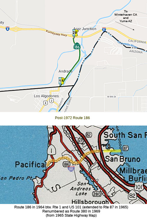 From the international boundary near Algodones to Route 8.
 Post 1964 Signage History
 ▸ In 1963, Route 186 was defined as "Route 1 near Pacifica to
Route 101 near San Bruno."
▸ In 1963, Route 186 was defined as "Route 1 near Pacifica to
Route 101 near San Bruno."
▸ In 1965, Chapter 1372 added the portion from Route 101 to Route 87: "Route 1 near Pacifica to Route 87 via the vicinity of Route 101 near San Bruno."
▸ In 1969, Chapter 294 renumbered this route as Route 380.
▸ In 1972, Chapter 742 redefined the route as "From the international boundary near Algodones to Route 8. " Chapter 1216 in 1962
did the same thing; in 1990, Chapter 216 removed the duplicate definition.
 Pre 1964 Signage History
The 1964-1969 routing of Route 186 was LRN 229, defined in 1947.
The post-1972 routing of Route 186 was not defined in 1963.
The post-1972 routing is centered around the community of Andrade.
Andrade is located on the grounds of what was once the Butterfield
Overland Mail Route stage station known as Pilot Knob. The Alamo Canal was
constructed during 1900 and 1901, and passed by the site of Pilot
Knob. The Alamo Canal originally connected from the Colorado River
south to the head of the Alamo River in Mexicali Valley. During 1904 a
breach in the Alamo Canal four miles south of Pilot Knob in Sonora was
opened. This breach lacked headgates and was intended to bring
additional waters from the Colorado River into Imperial Valley. The
unintended consequence of this action was entire Colorado River flow fully
diverting into the Salton Sink numerous times during 1904-1906. The
breach Alamo Canal was closed by the Southern Pacific Railroad during
February 1907 during the construction of the Inter-California Railway.
(Source: Gribblenation Blog (Tom Fearer), "California State Route 186", 8/1/2023)
Sign Route 186 was not defined as part of the initial state signage of routes in 1934. It is unclear what (if any) route was signed as Sign Route 186 between 1934 and 1964.
 Status
In December 2019, the CTC authorized vacation of right of way in the
county of Imperial on Route 186 from the US/Mexico border to the southerly
end of the turn-around cul-de-sac (11-Imp-186-PM 0.0/0.1), consisting of
highway right of way no longer needed for State highway purposes.
(Source: December 2019 CTC Agenda, Agenda Item
2.3d)
All American Canal Project (11-IMP-186 0.5/2.1)
In May 2020, the CTC had on its agenda notice of a STIP
amendment for PPNO 1411 – [SR 186 All American Canal project]
Program $4,500,000 of STBGP CBI funds in Imperial County. This
project is located on Route 186 from 0.5 mile north of the United States
(US)/Mexico Border to the Interstate 8 Eastbound Offramp. The project will
realign the two-lane highway on a new alignment and will construct a new
bridge over the canal. The new bridge will also provide pedestrian access
across the canal. The highway provides the only access to the Algodones
Port of Entry at the US/Mexico Border and provides access to Quechan
tribal lands. The new bridge will better facilitate international and
interregional movement of people, goods, and services and improve safety.
(Source: May 2020 CTC Agenda, Agenda Item 2.1b(1))
In June 2020, the CTC approved the following STIP
amendment: PPNO 1411 – [SR 186 All American Canal project]
Program $4,500,000 of STBGP CBI funds in Imperial County. This project is
located on Route 186 from 0.5 mile north of the United States (US)/Mexico
Border to the Interstate 8 Eastbound Offramp. The project will realign the
two-lane highway on a new alignment and will construct a new bridge over
the canal. The new bridge will also provide pedestrian access across the
canal. The highway provides the only access to the Algodones Port of Entry
at the US/Mexico Border and provides access to Quechan tribal lands. The
new bridge will better facilitate international and interregional movement
of people, goods, and services and improve safety.
(Source: June 2020 CTC Agenda, Agenda Item
2.1a.(2))
 Other WWW Links
 Statistics
Overall statistics for Route 186:
 Pre-1964 Legislative Route
In 1933, Chapter 767 defined the route from "[LRN 23] near Palmdale to Swartout Valley" as a state highway. This was codified in the highway code as LRN 186 with the definition "[LRN 23] near Palmdale to [LRN 61] in Swartout Valley", but the routing was repealed later that year by Chapter 426. This occurred as part of a compromise to create the Arroyo Seco Parkway. The following is a quote from the Historical American Engineering Record on the Arroyo Seco Parkway:
Because gas tax funds were going to be needed to build the road, another formidable political force joined the alternately strident, persuasive, and aggrieved stakeholders: the State Highway Commissioners. Unless the Arroyo Seco Parkway could qualify as a state highway, it would not receive the tax funds that would maintain it. As guardians of the 1 ¼ cent highway gas tax fund doled out to counties and cities, however, the commissioners opposed adding any more mileage to the state highway system.
To solve the problem, Los Angeles County Supervisor Roger Jessup offered a swap: the county would take back ten to fifteen miles of the Pear Blossom Highway, which ran from Palmdale to Cajon Pass at the northeastern edge of Los Angeles County, allowing that mileage to be granted to the Arroyo Seco Parkway. The State Highway Commission balked at this idea, requiring the county to assume control of the entire thirty-four miles of the Pear Blossom Highway. To keep the scheme alive, the county agreed to this.
Miller amended her bill by inserting a provision that effectively removed the Pear Blossom Highway from the state system. The coalition of South Pasadena and Highland Park residents who supported the parks for which they had been assessed, led by Thrasher, sought an amendment to return previously levied park assessment funds in the Arroyo Seco to the cities losing the land to highway right-of-way. This amendment was defeated. Assembly Bill 2345 authorizing the Arroyo Seco Parkway passed the state assembly and senate by a large margin, and Governor Frank Merriam signed it into law on July 13, 1935. The bill did not specify the exact route.
It does not appear that the LRN 186 definition of the Pear Blossom Highway was signed as Route 138.
LRN 186 was redefined in 1959 by Chapter 1062 as the route from LRN 194 (Route 79) to LRN 19 (US 60) near Moreno. This was a transfer from LRN 194. This is the former routing of present-day Route 79 along Gilman Springs Road (the present routing is Lamb Canyon).
© 1996-2020 Daniel P. Faigin.
Maintained by: Daniel P. Faigin
<webmaster@cahighways.org>.
 Route 185
 Route 187