
 California Highways:
Click here for a key to the symbols used. An explanation of acronyms may be found at the bottom of the page.
 Routing
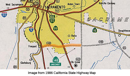 From Route 5 near Sacramento to Route 143 south of Route 16.
 Post 1964 Signage History
In 1963, the entirety of Route 148 was defined as "Route 5 near Sacramento to Route 143 south of Route 16." Segment (b) was added in 1985.
This was a proposed routing, and was LRN 248, defined in 1959, between LRN 238 (I-5) and LRN 247 (proposed Route 143). It is reported that Consumes River Road is an approximate routing for this, but it is not an adopted routing. Caltrans is apparently involved, however, with a street extension along Consumes River Road (for more information, see the entry for I-5). The following is from the approval for the I-5/Consumes River Road interchange:
Construction of the I-5/Cosumnes River Boulevard interchange was originally identified in a study of the Route 148 corridor conducted by the Department in the early 1960s. On February 27, 1963, the Department adopted the Route 148 freeway corridor segment between I-5 and Route 99. In 1974, the Commission withdrew the freeway designation of Route 148 due to financial constraints.
In a memorandum dated July 1, 1974, the County of Sacramento’s Department of Public Works recommended that the City of Sacramento maintain the adopted route as an east-west transportation corridor that would be less than freeway status. The City of Sacramento then embarked on the necessary steps to begin preserving right-of-way within the Route 148 corridor.
On November 4, 1981, the Sacramento City Council certified an Environmental Impact Report for the Route 148 Arterial Plan and adopted the route alignment for the arterial. That approval allowed the City to begin reserving the right-of-way for the future development of Route 148 and to construct segments of the approved route as funds became available. After approval of the Route 148 Arterial Plan, the name of the proposed facility was changed to Cosumnes River Boulevard. The names Route 148 and Cosumnes River Boulevard are synonymous and refer to the same proposed facility within the city of Sacramento.
The freeway route adoption was rescinded in 1975. The City of Scramento planned an arterial street (Consumes River Road) within the alignment; this precluded any state construction. E of Route 99, the city included a short portion of Calvine Road. As of 2002, Caltrans was recommending deleting the route from the state highway system.
 Status
The 2013 Traversable Highways report notes:
Cosumnes River Boulevard Extension
In March 2006, Sacramento released its draft environmental analysis for its planned $80 million Cosumnes River Boulevard extension. The project would extend Cosumnes River Boulevard from its current end point at Franklin Boulevard west to I-5 with a major interchange, and a short distance farther to Freeport Boulevard. Officials said construction is targeted to start in 2008, with a finish date in 2010.
According to an article in the Sacramento Bee, SACOG (Sacramento Area Council of Governments) is exploring a 30-plus-mile route that would start at I-5 in the south, head east across Route 99 in Elk Grove, and angle up the east county to US 50 in El Dorado County, skirting the edges of Rancho Cordova and Folsom. They are exploring the name "Cosumnes Parkway." The most often mentioned potential alignment would be along an extension of Kammerer Road between I-5 and Route 99, then along Grant Line Road and a straightened White Rock Road. Tuttle said the road would be four lanes, with a limited number of intersections. It probably would have an overpass at Highway 16. Chris Sampang guesses this might be a revival of Route 148.
In May 2013, it was reported that the Cosumnes River
Boulevard Extension and I-5 Interchange Project had broken ground. The
project will provide east-west connectivity between Route 99 and I-5, as
well as open up room for an 800-acre Delta Shores development. The cost is
about $82M. Sacramento officials say this project is expected to take
around two years complete and should be finished by 2015. The project will
also include more traffic lanes, on street bike lanes, and provide access
to two future regional transit light rail stations to Cosumnes River
College.
(Source: CBS Sacramento, 5/2/13)
In May 2015, it was reported that the new Cosumnes
River interchange with I-5, just one mile south of Meadowview Road, opened
for traffic on May 4 2015. The Cosumnes River Boulevard Extension project
from I-5 to Franklin Boulevard is scheduled to be open for traffic by fall
2015.
(Source: Project Page)
In December 2015, it was reported that the 3-plus-mile,
$95 million Cosumnes River Boulevard extension opened, offering a major,
new east-west connector between Route 99 and I-5. The road, which
alternates between four and six lanes, connects from Franklin Road to
Freeport Boulevard and includes a major interchange at I-5 near the town
of Freeport, just south of the Meadowview and Pocket areas of Sacramento.
The new road and interchange also pave the way for construction of Delta
Shores, a major shopping center and residential community – the
biggest Sacramento has seen since the North Natomas area opened 15 years
ago.
(Source: Sac Bee, 12/15/2015)
 In August 2010, Sen. Feinstein requested funding for the Capital Southeast Connector, a proposed 37-mile downtown Sacramento bypass, from I-5 in Elk Grove to US 50 in El Dorado Hills. The requested funding would support the
construction of an initial phase in the City of Elk Grove at Route 99,
which will be completed in 2012. The total cost of the Elk Grove segment
is $36 million, towards which the City has secured $34 million. This is
approximately the Route 148 routing.
In August 2010, Sen. Feinstein requested funding for the Capital Southeast Connector, a proposed 37-mile downtown Sacramento bypass, from I-5 in Elk Grove to US 50 in El Dorado Hills. The requested funding would support the
construction of an initial phase in the City of Elk Grove at Route 99,
which will be completed in 2012. The total cost of the Elk Grove segment
is $36 million, towards which the City has secured $34 million. This is
approximately the Route 148 routing.
(Image source: Capitol SE Connector JPA Website)
The project is divided into a number of segments:
(Source: Capitol SE Connector Findings of Fact Statement of Overriding Consideration)
For structuring purposes, the project is divided as follows:
(Source: Capitol SE Corridor Details Page)
In January 2016, an update was provided on the Capital SouthEast Connector. This is a 34 mile "limited access" parkway style expressway connecting I-5 S of Elk Grove and US 50 in the El Dorado Hills. Various segments are completed and the Silva Valley Interchange is under construction. Another 19 miles are in the environmental clearance phase, including the 5-mile Folsom/El Dorado segment that is about to enter final design.
This is not a Caltrans project. The group behind the effort was expecting
funding from Measure B in 2017. The connector joint powers board –
made up of representatives from Sacramento and El Dorado counties, and
from the cities of Folsom, Elk Grove and Rancho Cordova – had to
determine what to do when that measure failed. It will take several
decades to get the expressway built. Even then, it will be a smaller road
than first imagined. Previously, officials talked of building six lanes in
some spots, with interchanges instead of intersections, with an estimated
cost at one point of $700 million. Eventually, when expected east county
growth causes congestion on the new road, the connector could be turned
into a full expressway by turning intersections into interchanges. The
group built an initial 2.2-mile section in 2012, expanding and
straightening part of White Rock, from Grant Line to Prairie City Road.
That section offers a preview of what the entire corridor will look like.
Future sections are expected to have a bike trail separated from the
roadway. Despite the ballot box setback, the connector project is far from
financially bereft. It is in line to receive $118 million over the next
two decades from the county’s existing Measure A transportation
sales tax, approved by voters in 2004. The connector group also will
collect fees from developers who build housing projects near the connector
corridor. The group currently has $15 million it plans to use in 2018 to
further widen another 2 miles of White Rock Road to four lanes between
Prairie City Road and the northern branch of Scott Road. Planners said
they had hoped to build a longer section all the way to Latrobe Road in El
Dorado County but do not yet have the extra $24 million that would cost.
(Source: Andy Field on AARoads, "Re: Capital Southeast Connector (Sacramento, CA)", 1/2/2017)
In 2018, it was reported that a $20 million grant was secured for the
Capital Southeast Connector.
(Source: Chris Sampang on AARoads, "Re: Capital Southeast Connector (Sacramento, CA)", 8/13/2018)
In July 2020, Scott Parker noted on AARoads that it's likely the corridor
will use Caltrans templates for suburban/rural expressway. The
Sacramento-area project doesn't replace any existing state facilities,
though eventually the Route 148 designation may be applied to the final
product more for navigational purposes than anything (and it would get
Caltrans off the fiscal hook as far as developing the long-dormant Route 148 corridor is concerned) -- although undoubtedly considerable state
funds would be mixed into the project development.
(Source: Scott Parker on AARoads, "Re: Capital Southeast Connector (Sacramento, CA)", 7/14/2020)
In terms of current status, it was reported that the section of White
Rock Road between Prairie City Road and East Bidwell/Scott Road in Folsom
is about to get upgraded to expressway. Authorities have already
moved the utility lines about 200 feet south of the existing
roadway. Planning for the expressway was first announced in
2001. This is the third stretch of the expressway to be
constructed. The first section, from Prairie City Road to the Grant
Line Road-White Rock Road split was completed in 2014. The second
section from Route 99 to Waterman Road was completed around 2016 or
so. The next section of Grant Line Road that will be upgraded will
be the section between Waterman Road and Bradshaw Road in Elk Grove.
(Source: Concrete Bob on AARoads, "Re: Capital Southeast Connector (Sacramento, CA)", 7/15/2020)
In May 2020, the CTC approved the following allocation: $25,000,000. PPNO
03-1785. ProjID 0320000120. Capital Southeast connector - Segment D3. In
Folsom on White Rock Road in the vicinity of the Scott Road Intersection.
Widen 1 mile of 4-lane roadway and signalize 1 Intersection.
(Source: May 2020 CTC Agenda, Agenda Item 2.5s.(9))
In June 2020, the CTC approved an allocation of $10,800,000 for the
locally-administered Multi-Funded Senate Bill 1 (SB 1) Local Partnership
Program (LPP) (Competitive)/State Transportation Improvement Program
(STIP) Capital Southeast Connector – Segment B2 (PPNO 1784) project.
This project is in Elk Grove on Grant Line Road from Waterman Road to
Bradshaw Road. Realign and widen from 2 to 4 lanes and signalize at Mosher
Road and Bradshaw Road (Part of the overall Capital Southeast Connector
project).
(Source: June 2020 CTC Agenda, Agenda Item
2.5s.(7))
In March 2021, the CTC approved the request from the Sacramento
Transportation Authority to deprogram $700,000 in 2018 competitive program
funding from the Capital SouthEast Connector Expressway Project- Segment
B2. The implementing agency, City of Elk Grove, realized cost $700,000
savings due to the contract bids coming in lower than anticipated. The
agency requested to program that $700,000 to the Segment A2 project to
expand the project scope that provides additional quantifiable benefits.
The project scope will increase from constructing 2 lane miles of road to
a total of 3.3 lane miles providing additional paved shoulder for biking.
This expanded scope will further increase safety, reliability, mobility,
reduce congestion, and improve air quality. With the approval, the Capital
SouthEast Connector Expressway Project, Segments B2 and A2 will result in
the following programmed totals and project scope:
(Source: March 2021 CTC Agenda, Agenda Item 4.25)
In May 2021, it was reported that planning was continuing for the Plans
are 34-mile expressway that will connect I-5 to Route 99 just south of Elk
Grove. The route will follow Grant Line Road all the way to the southern
part of Folsom, then crosses into El Dorado County where it will meet up
US 50 at the new Silva Valley interchange. The project will begin with
phase one, which will include construction of four continuous lanes from
I-5 and Route 99 in Elk Grove to the Silva Valley interchange at Route 50
in El Dorado Hills. The first phase will also see expanded at-grade
intersections at all major access points, and a continuous path for
pedestrians, bicyclists and equestrians. However, some hurdles, like
funding, still stand in the way of the project. The project will cost
roughly $450 million for just the first phase, and board members said the
source of that funding is "unknown." The project will likely rely a lot on
state and federal partners.
(Source: ABC10, 5/5/2021)
In October 2021, it was reported that northbound and southbound Prairie
City Road – between White Rock Road and US 50 – would be
temporarily closed for work on the Capital SouthEast Connector project.
Crews will complete construction on a four-lane bridge over Alder Creek
and complete the realignment and widening of Prairie City Road and White
Rock Road. The section of road will be closed for up to eight weeks. The
city has installed message signs to alert motorists about the closure, and
flaggers will direct traffic as needed. The Capital SouthEast Connector
project is a 34-mile expressway that will link I-5 and Route 99 south of
Elk Grove to US 50 east of El Dorado Hills. When complete, the project
will serve as a commute alternative to US 50 and Route 99, relieve traffic
congestion, promote economic development, preserve Sacramento County open
spaces, and improve roadway safety. Work on the Capital SouthEast
Connector project has been divided into segments, which will be completed
as funding is available.
(Source: City of Folsom, 9/14/2021)
In December 2021, it was reported that there has been significant
progress on the Capital Southeast Connector. Kammerer Road has been
upgraded to a two-lane divided road from Bruceville Road to just west of
West Stockton Boulevard in Elk Grove. The authority responsible for
constructing the connector will be adding an additional lane in each
direction as funding and vehicle count direct. This section of the
connector has a break in the center median where Kammerer Road has a group
of driveways to about ten homes. A two-way left turn lane exists in
this area. This section of the connector has a posted 55 MPH speed
limit. This section of road is a little under three miles. It
was completed in late November 2021. The one-mile section of Grant Line
Road between Waterman and Bradshaw Road is nearly complete. This
portion of the connector has four lanes with a raised center median.
All the traffic is currently using the northeast-bound carriageway.
It appears contractors only need to complete the lane striping and
activate the traffic signals at Grant Line, Mosher and Bradshaw
Roads. Additionally, there is some sort of collector road to the
right of the connector to provide access to the farms to the south of the
connector. Finally, the section of White Rock Road between Prairie
City Road and East Bidwell Street in South Folsom is also coming close to
complete. The westbound lanes of the connector have been paved, but
the surface appears to need some additional minor treatment before
contractors can apply striping to the westbound roadbed.
(Source: Concrete Bob on AARoads, “Re: Capital Southeast Connector (Sacramento, CA)”, 12/16/2021)
In March 2022, it was reported that the section between Waterman and
Bradshaw Roads is complete, and traffic flows in each of the
carriageways. There are three traffic lights on the stretch from
Waterman to Bradshaw Roads. The road has a posted speed of 55
MPH. The road tapers to a two-lane road just east of Bradshaw. There
hasn't been any progress on the upgrade of White Rock Road between Prairie
City Road and East Bidwell Road in South Folsom. By May 2022, it was
reported that the westbound carriageway is fully opened and striped.
The temporary "stripage" for the eastbound lanes have been removed, and is
nothing but blacktop. All the new traffic lights have been
installed, but they are not operational. Two of the three signal
lights are being served by active traffic lights hung on adjacent electric
lines (Prairie City Road/Oak Avenue Parkway), while the third (East
Bidwell) is served by new lights flashing red signals. The eastbound
carriage has the area for the right lane blocked off by traffic cones. By
June 2022, both carriages were open, and all three new traffic lights were
functioning. The only thing remaining was the realignment of Scott
Road to tie in with the Prairie City Road intersection. The
four-lane divided connector continued about 1,000 feet east of East
Bidwell, where it tapers to the old two-lane configuration. The road has a
posted speed of 55 MPH. There is also ample right of way set aside
for future tight diamond interchanges at Prairie City Road and East
Bidwell Street.
(Source: Concrete Bob on AARoads, “Re: Capital Southeast Connector (Sacramento, CA)”, 3/2/2022, 5/20/2022, 6/5/2022)
In February 2023, the Folsom segment of the Capital Southeast Connector
expressway was opened. This was a major milestone in the planned 34-mile
roadway linking I-5 in Elk Grove to US 50 just east of the Folsom in El
Dorado County. The expressway has a 3-mile segment that includes a
separated Class 1 bike and pedestrian trail, new traffic signals, improved
intersections and bridges over Alder Creek.
(Source: $ Sacramento Bee, 2/20/2023)
In November 2023, it was noted that the Federal Register published a
notice indicating DOT approval of a proposed project, to connect Route 99
to I–5 in an eastwest alignment, in unincorporated Sacramento County
and a portion of the City of Elk Grove. Specifically, the City of Elk
Grove and Capital SouthEast Connector Joint Powers Authority (Connector
JPA), in cooperation with the California Department of Transportation
proposes
to connect Route 99 to I–5 in an east-west alignment. The project
will replace an existing portion of Kammerer Road with a four-lane
thoroughfare, construct a new four-lane expressway section to I–5.
(Source: Federal Register, 11/27/2023)
 Interstate Submissions
Submitted for inclusion in the interstate system in 1958; not accepted.
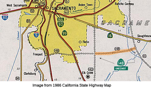 From Route 143 south of Route 16 to Route 65.
Post 1964 Signage HistoryIn 1963, (a) was the entirety of Route 148. In 1985, Chapter 46 added segment (b): "(b) Route 143 south of Route 16 to Route 65." In 1990, Chapter 1187 fixed the formatting.
In 2002, the Traversable Highways report noted that some studies have been conducted but further analysis is needed regarding a route adoption. There is no traversable highway and the area is built-out precluding any new alignment. Caltrans recommended removing the route from the state highway system.
The 2013 Traversable Highways report notes for this segment: General routing not determined - No traversable highway - This area is being built out in a manner precluding any new highway alignment. District 3 continues to recommend removal of the route from the State Highway System.
 Pre 1964 Signage History
Signed Route 148 was not defined as part of the initial state signage of routes in 1934. It is unclear what (if any) route was signed as Route 148 between 1934 and 1964.
 Freeway
[SHC 253.1] Entire route. Added to the Freeway and Expressway system in 1959.
 Other WWW Links
 Statistics
Overall statistics for Route 148:
 Pre-1964 Legislative Route
In 1933, Chapter 767 added the route from "Guadalupe to Sisquoc via Santa Maria" to the state highway system. In 1935, this was added to the highway code as LRN 148 as follows:
"[LRN 56] near Guadalupe to Sisquoc via Santa Maria"
The definition remained unchanged until the 1963 renumbering. This is present-day Route 166 between Route 1 and Santa Maria, and was 1964-1984 Route 176 between Santa Maria and Sisquoc. The highway continued from Sisquoc (although not as part of the present state highway system) to Los Olivos. The route from Santa Maria from Broadway (former US 101) E on Stowell Rd to Philbric Road, then to Foxen Canyon Road, and along Foxen Canyon Road to Sisquoc. Foxen Canyon Road continues into Los Olivos, but does not appear to have been part of the state highway.When the US 101 bypass was completed in the early 1960s, the revised routing ran along Main Street between Broadway and US 101, and S on US 101 to Stowell.
© 1996-2020 Daniel P. Faigin.
Maintained by: Daniel P. Faigin
<webmaster@cahighways.org>.
 Route 147
 Route 149