
 California Highways:
Click here for a key to the symbols used. An explanation of acronyms may be found at the bottom of the page.
 Routing
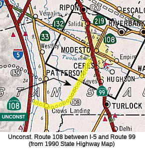
 From Route 5 near Crows Landing to Route 99 near Modesto.
 Post 1964 Signage History
In 1963, this segment was defined as "From Route 5 near Crows Landing to Route 99."
In 2009, SB 532 (Chapter 189, 10/11/2009) clarified the terminus as "Route 99 near Modesto"
 Pre 1964 Signage History
This was LRN 109 (1959 extension), and was a proposed routing.
 Status
This part is unconstructed. The traversable local routing runs along Fink Road and Crows Landing Road from Crows Landing to Modesto. The county has inquired about the state adopting this route, but the state has no plans to do so.
The 2013 Traversable Highway report indicated that the following segment is Category 3 — The traversable highway is inadequate or nonexistent, but project studies are scheduled within five years so State assumption of maintenance is a possibility within the next ten years: From Route 33 to Route 99. (Crow's Landing Road). (17.9 mi). The report also noted:
 From Route 132 in Modesto to Route 120 east of Oakdale.
Post 1964 Signage HistoryIn 1963, this segment was defined as "(b) Route 99 to Route 120."
In 1984, Chapter 409 changed the origin of this route from "Route 99" to "Route 132 in Modesto", and clarified the terminus as "Route 120 in Oakdale." This deleted portion of (b) from Route 99 to Route 132.
In 2009, SB 532 (Chapter 189, 10/11/2009) changed the terminus to "Route 120 in east of Oakdale."
Pre 1964 Signage HistoryThis was LRN 109 between Route 132 (originally from US 99) to present-day Route 219. It was defined in 1933.
Between Route 219 and Route 120, this was LRN 13, defined as part of the
state highway system in 1909.This was not signed as part of Route 108
until 1961. Tom Fearer noted that the July/August 1961 California Highways
& Public Works announced that Route 108 was extended to Modesto from
Yosemite Junction via LRN 13 and LRN 109.
(Source: Gribblenation Blog (Tom Fearer): "Trans-Sierra Highways; California State Route 108 over Sonora Pass").
Note that LRN 13 continues W to Salida, and was part of the original definition of LRN 13 defined in 1909. It does not appear that this was signed.
E of this point, Route 108 is cosigned with Route 120 to Yosemite Junction. This cosignage occurred around 1961.
StatusOakdale Bypass
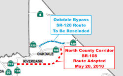 In January 2012 (and again in April 2012), the CTC approved a notice of consideration to rescind a
freeway adoption (the actual recission occured in May 2013). As
background, in the early 2000s, a consensus was reached to construct a
freeway on a new alignment along Route 120 to bypass the City of Oakdale,
also known as the Oakdale Bypass/Expressway. On December 11, 2002, the
Commission adopted the current Route 120 corridor. Numerous parcels, but
not all, were purchased to obtain the necessary right of way for the
adopted Route 120 Oakdale Bypass. Since that time, a lack of funding and
changing traffic patterns have resulted in a community and Department
agreement to drop the pursuit of the Oakdale Bypass in favor of an
alternative route. Consequently, the Department is proposing to rescind
the Route 120 freeway route adoption, from Valley Home Road to a point
approximately 2.8 miles east of Lancaster Road in Stanislaus County. Route 120 and Route 108 are the main routes to the fast growing Tuolumne County,
carrying a adediverse mixture of commercial, agricultural, recreational,
commuter, truck and local traffic. Traffic on both Route 120 and Route 108
into and through Oakdale has been growing for several decades which led to
a growing traffic congestion problem. The Department and the local
community have been struggling to address it for many years. Congestion is
most severe on weekends due to recreational traffic traveling to Yosemite
National Park, the Jamestown and Sonora areas, and points east. The
elevated interregional traffic demand often conflicts with local demand
resulting in congestion, increased noise and air pollution. The area most
severely affected is at the junction of Route 120 and Route 108 (Yosemite
Avenue and F Street) in downtown Oakdale where the level of service in
2001 was classified as “F”, representing heavily congested
traffic with long delays. The level of service was projected to continue
to degrade to „very high delays‟ by the year 2020 in the
absence of any system improvements.
In January 2012 (and again in April 2012), the CTC approved a notice of consideration to rescind a
freeway adoption (the actual recission occured in May 2013). As
background, in the early 2000s, a consensus was reached to construct a
freeway on a new alignment along Route 120 to bypass the City of Oakdale,
also known as the Oakdale Bypass/Expressway. On December 11, 2002, the
Commission adopted the current Route 120 corridor. Numerous parcels, but
not all, were purchased to obtain the necessary right of way for the
adopted Route 120 Oakdale Bypass. Since that time, a lack of funding and
changing traffic patterns have resulted in a community and Department
agreement to drop the pursuit of the Oakdale Bypass in favor of an
alternative route. Consequently, the Department is proposing to rescind
the Route 120 freeway route adoption, from Valley Home Road to a point
approximately 2.8 miles east of Lancaster Road in Stanislaus County. Route 120 and Route 108 are the main routes to the fast growing Tuolumne County,
carrying a adediverse mixture of commercial, agricultural, recreational,
commuter, truck and local traffic. Traffic on both Route 120 and Route 108
into and through Oakdale has been growing for several decades which led to
a growing traffic congestion problem. The Department and the local
community have been struggling to address it for many years. Congestion is
most severe on weekends due to recreational traffic traveling to Yosemite
National Park, the Jamestown and Sonora areas, and points east. The
elevated interregional traffic demand often conflicts with local demand
resulting in congestion, increased noise and air pollution. The area most
severely affected is at the junction of Route 120 and Route 108 (Yosemite
Avenue and F Street) in downtown Oakdale where the level of service in
2001 was classified as “F”, representing heavily congested
traffic with long delays. The level of service was projected to continue
to degrade to „very high delays‟ by the year 2020 in the
absence of any system improvements.
 In 1990, a Value Engineering study for the Route 120
Oakdale Bypass project identified a need to further study the development
of a Route 108 southern bypass as well as the need for the Route 120
Oakdale Bypass itself. The Department and local entities identified the
preferred alternative for the Oakdale Bypass as a northern corridor
expressway starting across the Stanislaus River near Twenty Six Mile Road
and ending eight miles east of Oakdale. The Route 120 Oakdale Bypass was
adopted by sthe Commission in 2002. During this same time period, changing
traffic patterns in Stanislaus County were fostering a growing realization
that a southern bypass of Riverbank and Oakdale (i.e. the NCC) was in
critical need and should perhaps be given a higher priority than the
northern Oakdale Bypass. As a result, StanCOG, the Cities of Modesto,
Riverbank, and Oakdale, and the County of Stanislaus identified the NCC as
a priority corridor. In 2007, following several years of project delay due
to inadequate funding of the Oakdale Bypass, the Commission redirected the
Oakdale Bypass project Interregional Transportation Improvement Program
(ITIP) funds under the authority of the resolution approving the 2006
State Transportation Improvement Program (STIP) Augmentation, with the
understanding these funds would be restored to a viable replacement
project in the future. In May 2008, the Commission deleted all programming
from the Oakdale Bypass project under the authority of Resolution G-08-08
approving the 2008 STIP adoption and recognizing the NCC project as the
viable replacement project. In May 2010, the Commission approved the Route Adoption of the NCC Route 108 East under authority of Resolution HRA 10-02
Commiand HRA 10-03.
In 1990, a Value Engineering study for the Route 120
Oakdale Bypass project identified a need to further study the development
of a Route 108 southern bypass as well as the need for the Route 120
Oakdale Bypass itself. The Department and local entities identified the
preferred alternative for the Oakdale Bypass as a northern corridor
expressway starting across the Stanislaus River near Twenty Six Mile Road
and ending eight miles east of Oakdale. The Route 120 Oakdale Bypass was
adopted by sthe Commission in 2002. During this same time period, changing
traffic patterns in Stanislaus County were fostering a growing realization
that a southern bypass of Riverbank and Oakdale (i.e. the NCC) was in
critical need and should perhaps be given a higher priority than the
northern Oakdale Bypass. As a result, StanCOG, the Cities of Modesto,
Riverbank, and Oakdale, and the County of Stanislaus identified the NCC as
a priority corridor. In 2007, following several years of project delay due
to inadequate funding of the Oakdale Bypass, the Commission redirected the
Oakdale Bypass project Interregional Transportation Improvement Program
(ITIP) funds under the authority of the resolution approving the 2006
State Transportation Improvement Program (STIP) Augmentation, with the
understanding these funds would be restored to a viable replacement
project in the future. In May 2008, the Commission deleted all programming
from the Oakdale Bypass project under the authority of Resolution G-08-08
approving the 2008 STIP adoption and recognizing the NCC project as the
viable replacement project. In May 2010, the Commission approved the Route Adoption of the NCC Route 108 East under authority of Resolution HRA 10-02
Commiand HRA 10-03.
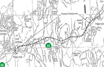
North County Corridor (~ STA 27.679 to 120 STA 11.375)
![[108 Oakdale]](maps/108-oakdale.jpg) In May 2010, the CTC approved for future consideration of funding a project in Stanislaus County that would
study corridor options for a future alignment of Route 108 near the city
of Oakdale. There is no construction for this project because it is for
route adoption only. Once the route adoption is approved by the
Commission, and funding becomes available, the Stanislaus Council of
Governments and the Department will conduct further environmental studies
to identify a roadway alignment within the selected corridor. The
construction of the new roadway is anticipated to occur in Fiscal Year
(FY) 2025. Conceptual level cost estimates to build a new roadway range
from $600 to $800 million (FY 2009 costs), and $1.3 to $1.5 billion (FY
2030 costs). It is expected that the future project, however, will have
potential impacts to land use, farmlands, cultural resources, biological
resources, relocations, hazardous waste, water quality, paleontology, and
air quality.
In May 2010, the CTC approved for future consideration of funding a project in Stanislaus County that would
study corridor options for a future alignment of Route 108 near the city
of Oakdale. There is no construction for this project because it is for
route adoption only. Once the route adoption is approved by the
Commission, and funding becomes available, the Stanislaus Council of
Governments and the Department will conduct further environmental studies
to identify a roadway alignment within the selected corridor. The
construction of the new roadway is anticipated to occur in Fiscal Year
(FY) 2025. Conceptual level cost estimates to build a new roadway range
from $600 to $800 million (FY 2009 costs), and $1.3 to $1.5 billion (FY
2030 costs). It is expected that the future project, however, will have
potential impacts to land use, farmlands, cultural resources, biological
resources, relocations, hazardous waste, water quality, paleontology, and
air quality.
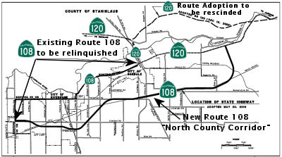
Specifically, the proposal is to modify the adopted route for Route 108 in Stanislaus County, in the vicinity of the cities of Modesto, Riverbank, and Oakdale. The ultimate facility is planned as a multi-lane freeway/expressway corridor, approximately 18 miles long. A Project Report was approved on April 13, 2010. An Environmental Impact Report was prepared for California Environmental Quality Act and the document was approved on April 13, 2010. This 18 mile long project, referred to as the North County Corridor (NCC) Route 108 East Route Adoption, will bypass the cities of Riverbank and Oakdale, improve interregional system connectivity, and improve regional traffic operations.
Route 108 is generally classified as a minor arterial through most of the project limits except for sections through the cities of Riverbank and Oakdale that are classified as principal arterial. Existing Route 108 functions as a “main street” and is predominantly a two-lane undivided conventional facility. Between the intersection of Route 108 (McHenry Avenue)/SR 219 (Kiernan Avenue) and the intersection of Route 108/Route 120 with Lancaster Road, Route 108 is encumbered by 83 public street intersections and many private driveways with direct access onto Route 108. It is highly congested during peak travel times and these conditions are expected to worsen as traffic volumes on Route 108 increase in the foreseeable future. Increasing levels of traffic on both Route 120 and Route 108 into and through the City of Oakdale have led to a growing traffic congestion problem that the Department and the local community have been addressing for over five decades. Traffic on Route 108 includes a combination of commuter, local commerce, goods movement, agricultural and farm operations, and a large component of interregional recreational traffic. This elevated interregional traffic demand often conflicts with local traffic demand resulting in congestion, increased noise and air pollution. Route 108 provides direct access to local residences, farms, and other community facilities along its route but also travels through the busy downtown areas of Oakdale and Riverbank. Congestion is most severe during weekends due to recreational traffic traveling to Yosemite National Park, and to the Jamestown and Sonora areas. Weekdays can also be very congested due to the heavy commute traffic. The area most severely affected by congestion is at the junction of Route 108 and Route 120 (Yosemite Avenue) in downtown Oakdale where the level of service (LOS) in 2001 was classified as “F”, representing heavily congested traffic with long delays. These conditions are expected to worsen over time as development continues and traffic volumes increase. The LOS is projected to degrade to “very high delays” by the year 2020 in the absence of any system improvement.
The ultimate facility is planned as a multi-lane freeway, approximately ten miles long, from Route 219 and McHenry Avenue to just east of Albers Road and as a multi-lane
controlled access highway for the remaining eight miles until it connects
with Route 120, approximately six miles east of the City of Oakdale. The
freeway segment will serve the urban areas of Modesto, Riverbank, and
Oakdale. The controlled access highway segment is planned for the rural
area of Stanislaus County south-east of Oakdale. The route adoptions will
be executed as two concurrent CTC actions on this month’s agenda
(see also Resolution HRA 10-03). Although the North County Corridor
encompasses a roadway facility between Route 99 and Route 120, the
proposed State route adoption is only for the segment between Route 108
(McHenry Avenue) and Route 120. These limits are a result of discussions
occurring June 2008 to February 2009 between State and local entities. A
freeway adoption connecting to Route 99 was interfering with the
development of a modification proposal at the Hammett Road/Route 99
interchange. The Project Study Report for that project has assumed Hammett
would remain a local road and proposes a local type interchange at Route 99. The Department concurred to pursue evaluating the new NCC Route 108
East Route Adoption. This request is for the Freeway Route Adoption, and a
separate request is being submitted for the Controlled Access Highway
Route Adoption (Resolution HRA 10-03). These two route adoptions will
allow for the execution of a freeway agreement and a controlled access
highway agreement with Stanislaus County.
Relinquishment of the existing Route 108 will occur after construction of the new bypass. Relinquishment will transfer the State’s right of way, title, and interest of the superseded section of Route 108 to the City of Oakdale, City of Riverbank, and Stanislaus County as depicted in the attached Route Adoption Map.
 In September 2016, it was reported that one of the last
remaining battles over potential paths for the future North County
Corridor may be nearing an end, with momentum building for a tie-in with
existing Route 108 east of Oakdale at Lancaster Road. Dozens of families
in neighborhoods four miles to the west for months have protested the
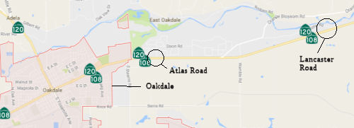
concept of a roundabout at Atlas Road, with the North County Corridor
shooting south from that point and paralleling Stearns Road before
skirting Oakdale and running between Riverbank and Modesto. Oakdale
officials previously preferred the Atlas tie-in, thinking it might funnel
cars near a future shopping center; however, the city has changed its mind
and has adopted a resolution supporting the neighbor-preferred Lancaster
option. The EIR should be released in January 2017. Controversy over the
road’s western stretch, between Modesto and Riverbank, died down a
few years ago as engineers focused on redoing Kiernan Avenue, with
legitimate freeway interchanges at McHenry Avenue, Coffee and Oakdale
roads, and Roselle Avenue. If Caltrans picks the Lancaster tie-in on the
east end, the only unresolved choice would be south of Oakdale, with one
option close to the south edge of the city and the other further south,
largely focused on Claribel Road. Leaders of the county and three cities
would review the draft environmental study around March, accepting input
from the public and seeking consensus among each other. Caltrans’
final route selection could follow in early 2018.
In September 2016, it was reported that one of the last
remaining battles over potential paths for the future North County
Corridor may be nearing an end, with momentum building for a tie-in with
existing Route 108 east of Oakdale at Lancaster Road. Dozens of families
in neighborhoods four miles to the west for months have protested the
concept of a roundabout at Atlas Road, with the North County Corridor
shooting south from that point and paralleling Stearns Road before
skirting Oakdale and running between Riverbank and Modesto. Oakdale
officials previously preferred the Atlas tie-in, thinking it might funnel
cars near a future shopping center; however, the city has changed its mind
and has adopted a resolution supporting the neighbor-preferred Lancaster
option. The EIR should be released in January 2017. Controversy over the
road’s western stretch, between Modesto and Riverbank, died down a
few years ago as engineers focused on redoing Kiernan Avenue, with
legitimate freeway interchanges at McHenry Avenue, Coffee and Oakdale
roads, and Roselle Avenue. If Caltrans picks the Lancaster tie-in on the
east end, the only unresolved choice would be south of Oakdale, with one
option close to the south edge of the city and the other further south,
largely focused on Claribel Road. Leaders of the county and three cities
would review the draft environmental study around March, accepting input
from the public and seeking consensus among each other. Caltrans’
final route selection could follow in early 2018.
(Source: Modesto Bee, 9/22/2016)
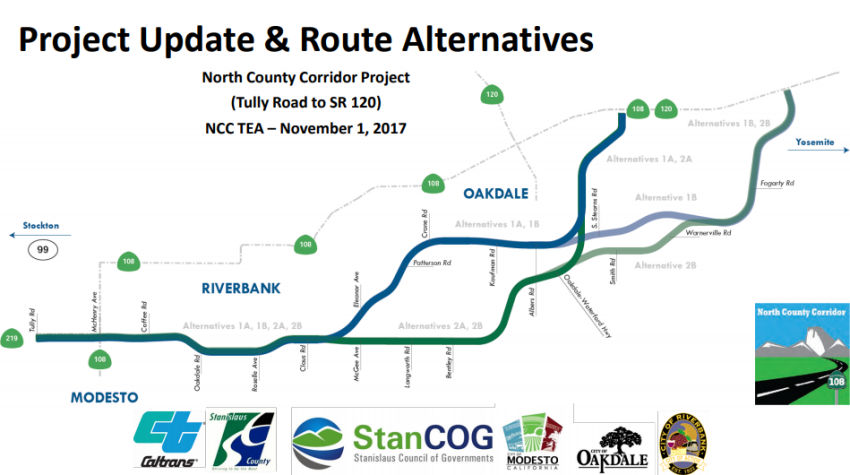
The August 2017 Draft EIR noted: The proposed project
will connect Route 219 near Modesto to Route 120 near Oakdale. This
environmental document analyzes the four Build Alternatives (1A, 1B, 2A,
and 2B) and the NoBuild Alternative. The western end of all alternatives
is at the Route 219 (Kiernan Avenue)/Tully Road intersection. The project
is analyzed as three distinct segments for environmental evaluation
purposes and explaining the proposed improvements. Segment 1 represents
the more urbanized area; Segment 2 represents a transition from urbanized
to rural area; and Segment 3 represents the rural foothill area.
(Source: NCC DEIR August 2017)
 Segment 1 begins at the Route 219 Kiernan Avenue/Tully Road intersection, which is
the western end of the project for all four alternatives. All of the Build
Alternatives proceed along the same alignment, extending to the existing
Claus Road/Claribel Road intersection near the southeast portion of the
City of Riverbank and northeast portion of the City of Modesto’s
future sphere of influence, including future areas projected to be
incorporated into the City boundaries. The following
interchange/intersection designs are common to all Build Alternatives for
Segment 1: (◆) Tully Road/Route 219 (Kiernan Avenue) intersection
will consist of a modified signalized at-grade intersection; (◆)
Route 108 (McHenry Avenue)/Route 219, (Kiernan Avenue)/new Route 108,
Coffee Road/new Route 108, Oakdale Road/new Route 108, and Roselle
Avenue/new Route 108 will all consist of a proposed single-point urban
interchange and separate-grade undercrossing structures; (◆) The
Claus Road/new Route 108 signalized at-grade intersection will provide
access from the new Route 108 facility east of Claus Road as well as the
local road access to the City of Riverbank and future northeastern areas
of the City of Modesto.
Segment 1 begins at the Route 219 Kiernan Avenue/Tully Road intersection, which is
the western end of the project for all four alternatives. All of the Build
Alternatives proceed along the same alignment, extending to the existing
Claus Road/Claribel Road intersection near the southeast portion of the
City of Riverbank and northeast portion of the City of Modesto’s
future sphere of influence, including future areas projected to be
incorporated into the City boundaries. The following
interchange/intersection designs are common to all Build Alternatives for
Segment 1: (◆) Tully Road/Route 219 (Kiernan Avenue) intersection
will consist of a modified signalized at-grade intersection; (◆)
Route 108 (McHenry Avenue)/Route 219, (Kiernan Avenue)/new Route 108,
Coffee Road/new Route 108, Oakdale Road/new Route 108, and Roselle
Avenue/new Route 108 will all consist of a proposed single-point urban
interchange and separate-grade undercrossing structures; (◆) The
Claus Road/new Route 108 signalized at-grade intersection will provide
access from the new Route 108 facility east of Claus Road as well as the
local road access to the City of Riverbank and future northeastern areas
of the City of Modesto.
Segment 2 is where the four similar alternatives separate into two different alignments (1A/1B and 2A/2B). In Segment 2, Alternatives 1A and 1B veer northeast from near the existing Claus Road/Claribel Road intersection and pass through the southern boundary of the City of Oakdale to just east of Albers Road, and Alternatives 2A and 2B continue to extend easterly along Claribel Road and veer northeastward past the intersection of Claribel Road/Bentley Road to just east of Albers Road. In Segment 2:
In Segment 3, Alternatives 1A and 2A merge as similar alignments at the southern end of the City of Oakdale and continue on the same alignment to the proposed eastern end (A) at the new Route 108/Route 120 intersection just east of the City of Oakdale boundary. In Segment 3, Alternatives 1B and 2B merge as similar alignments north of the existing Warnerville Road/Emery Road intersection and continue on a northeasterly direction to the proposed other eastern end (B) at the new Route 108/Route 120 intersection west of the existing Route 120/Lancaster Road intersection. In Segment 3:
In November 2018, the Stanislaus County Public Works
Department noted that, on October 3, 2016, the Oakdale City Council passed
a resolution of preliminary support for NCC Alternatives 1B and 2B. With
the official release of the Draft EIR/EIS on August 9, 2017, City staff
has had the opportunity to review the Draft EIR/EIS and believes that
Alternative 1B should be the preferred alternative. At their September 18,
2017 meeting, the Oakdale City Council unanimously passed a resolution to
send Caltrans an official comment letter stating the City’s
preference for Alternative 1B. On October 24, 2017 City of Riverbank City
Council took the same action for similar reasons. The Riverbank City
Council unanimously passed a resolution adopting Alternative 1B as the
City’s preferred North County Corridor route Alignment.
(Source: Stanislaus County Public Works Presentation, 11/2018)
In December 2018, it was reported that Federal highway
officials approved a $20 million grant for the North County Corridor, a
future expressway skirting Modesto, Riverbank and Oakdale in north
Stanislaus County. The road is expected to cost $688 million and will
require additional funding. State transportation officials are expected to
pinpoint the exact route in early 2019, and construction could be a few
years away. The project was one of only four in California drawing BUILD
money, formerly known as TIGER grants; BUILD stands for Better Utilizing
Investments to Leverage Development. The corridor will be a west-east
facility from Route 108 (McHenry Avenue) north of the City of Modesto to
Route 120 approximately six miles east of the City of Oakdale. This new
roadway would be approximately 18 miles in length from a location on Route 219 (Kiernan Avenue) to a location on Route 120 approximately six miles
east of the City of Oakdale. The project may be an entirely new roadway or
incorporated into the existing roadway network and would serve as a bypass
for the cities of Riverbank, Oakdale and Modesto. The North County
Corridor Transportation Expressway Authority anticipates that the ultimate
facility would be planned as a multi-lane, access-controlled
expressway/freeway, with interchanges, at-grade intersections,
grade-separated railroad crossings, irrigation district crossings,
frontage roads, and local street alignments. Various roadway alignment
alternatives will be considered. The proposed roadway would be built in
existing unincorporated Stanislaus County. Funding for this phase of the
project is being provided by regional transportation impact fees and the
state funding that was once part of the cancelled state Oakdale Bypass
project.
(Source: Modesto Bee, 12/10/2018; NorthCounty
Corridor Webpage)
In June 2020, it was reported that the EIS for the
Route 108 Modesto bypass expressway, the first phase of which extends from
the Route 108/Route 219 junction north of Modesto to a terminus at present
Route 108/Route 120 east of Oakdale, has been approved. Stanislaus
County has a corridor design simulator that follows the facility, which is
being designed as a combination freeway/expressway, from west to
east. The routing has three roundabouts on the main expressway lanes
(3+3 on the west end; 2+2 east of Riverbank), along with several
interchanges at major arterials. Two of these are multi-lane; the
last one is at the eastern terminus as the connector to Route 120.
The expressway is designed to be upgradeable to full freeway (likely with
bridges over the circles); also, in a future phase this corridor will
follow Route 219 west to Route 99 near Salida.
(Source: Scott Parker on AARoads, "Re: California", 6/11/2020)
In December 2020, the CTC approved a route adoption and
future consideration of funding for the following project for which a
Final Environmental Impact Report (FEIR) has been completed: Route 108,
Route 219, and Route 120 in Stanislaus County (10-Sta-108, PM 27.5/44.5
• 10-Sta-219, PM 3.7/4.8 • 10-Sta-120, PM 6.9/11.6).
Construct a new freeway east of the City of Oakdale in Stanislaus County.
(PPNO 0228) This project is located on Route 108, Route 219, and
Route 120 in Stanislaus County, in the City of Modesto, City of Riverbank,
and City of Oakdale, from 0.1 mile west of the Route 219 (Kiernan
Avenue)/Tully Road Intersection in Stanislaus County to the new Route 108/Route 120 Junction east of the City of Oakdale. The purpose of this
project is to reduce average daily traffic volumes and traffic congestion
as well as accommodate anticipated future traffic on SR 108 and the
surrounding regional transportation network. This project is not fully
funded and the total project cost is $915,000,000. Construction is
estimated to begin in 2023.
(Source: December 2020 CTC Agenda, Agenda Item
2.2c.(1))
McHenry Avenue Widening (~ STA 29.069 / STA 31.785)
 The 2018 STIP, approved at the CTC March 2018 meeting, appears to allocate $4.1M, but delay to FY20-21, PPNO 3047 McHenry Av, Route 108
(Ladd/Patterson)-McHenry Bridge, widen. (~ STA 29.069 to STA 31.785). The
project is located 2.4 miles south of Route 120 near the City of Modesto.
The purpose of the project is to widen the existing 2 lane McHenry Avenue
to a total of 5 lanes from the intersection of Ladd/Patterson Road to the
south abutment of McHenry Avenue Bridge over the Stanislaus River. Work
associated with the roadway widening will include the reconstruction of
the roadway, remove existing McHenry Avenue Bridge over Dry Slough and
replace with a culvert topped with earthen fill, relocation of traffic
signal, restriping, install metal beam guardrail, storm sewer system, curb
and gutter, and a Class II bike lane. Project’s total cost is
approximated at $13,025,000.
The 2018 STIP, approved at the CTC March 2018 meeting, appears to allocate $4.1M, but delay to FY20-21, PPNO 3047 McHenry Av, Route 108
(Ladd/Patterson)-McHenry Bridge, widen. (~ STA 29.069 to STA 31.785). The
project is located 2.4 miles south of Route 120 near the City of Modesto.
The purpose of the project is to widen the existing 2 lane McHenry Avenue
to a total of 5 lanes from the intersection of Ladd/Patterson Road to the
south abutment of McHenry Avenue Bridge over the Stanislaus River. Work
associated with the roadway widening will include the reconstruction of
the roadway, remove existing McHenry Avenue Bridge over Dry Slough and
replace with a culvert topped with earthen fill, relocation of traffic
signal, restriping, install metal beam guardrail, storm sewer system, curb
and gutter, and a Class II bike lane. Project’s total cost is
approximated at $13,025,000.
The 2020 STIP, approaved at the March 2020 CTC meeting,
adjusts the programmed allocations for PPNO 3047 "McHenry Av, Rt 108
(Ladd/Patterson)-McHenry Bridge, widen" by increasing the amount from
$4.1M to $4.86M.
(Source: March 2020 CTC Agenda, Item 4.7, 2020 STIP
Adopted 3/25/2020)
In January 2021, the CTC approved for future
consideration of funding McHenry Avenue Widening Project. Widen
McHenry Avenue and other improvements. (MND) (PPNO 3047) (LPP)
(STIP). The Project will widen McHenry Avenue with two through lanes
in each direction, add a left-turn median lane, and remove an existing
bridge. The Project is located at the intersection of Ladd/Patterson Road
and extends 0.25-mile south (note: they
say "south", but it has to be "north") on McHenry Avenue to the
East River Road intersection, Stanislaus County. On November 7, 2017, the
Stanislaus County Board of Supervisors adopted a Mitigated Negative
Declaration for the Project and found that the Project would not have a
significant effect on the environment after mitigation. Impacts that
require mitigation measures to be reduced to less than significant levels
relate to aesthetics, air quality, biological and cultural resources,
hazardous waste, hydrology, noise, and traffic. Mitigation measures
include, but are not limited to the following: require adherence to the
Landscape Architecture Guide for replanting requirements, comply with
Standard Specifications Section 14-11.08E for dust control measures,
provide signage that prohibits disturbance of areas that are inhabited by
the Valley Elderberry Longhorn Beetle, contract with a qualified
archaeologist if cultural materials are unearthed, prepare a Spill
Prevention Control and Countermeasures Program, procure a National
Pollutant Discharge Elimination System Permit, install mufflers to
minimize internal combustion engine noise, and develop a Traffic Control
Plan. On November 30, 2020, the County confirmed that the preferred
alternative set forth in the Mitigated Negative Declaration is consistent
with the Project scope of work programmed by the California Transportation
Commission. The Project is estimated to cost $22,322,067 and is funded
through construction with State Transportation Improvement Program Funds
($4,860,000), County Funds ($8,675,000), Regional Surface Transportation
Funds ($1,206,958), Local Measure Funds ($2,605,000), Federal Highway
Infrastructure Funds ($2,647,109), Local Partnership Program Funds
($2,128,000) and Local Transportation Funds ($200,000). Construction is
estimated to begin in Fiscal Year 2020-21.
(Source: January 2021 CTC Agenda, Agenda Item
2.2c.(3))
Also in January 2021, the CTC approved an allocation of
$6,988,000 for the locally-administered multi-funded Senate Bill 1 (SB 1)
Local Partnership Program (LPP) (Competitive)/STIP McHenry
Avenue Widening-Ladd Road/Patterson Road to south end of McHenry Bridge
project (PPNO 3047), off the State Highway System, in Stanislaus County.
PPNO 10-3047; ProjID 1016000007. McHenry Avenue Widening-Ladd
Road/Patterson Road to south end of McHenry Bridge. N of Route 108 near Modesto and Escalon. Project limits are from Ladd Road/Patterson
Road (Route 108) to the south end of the McHenry bridge at the San Joaquin
County line. Widen McHenry Avenue, which is designated as a Minor
Arterial, with two through lanes in each direction and a dual left-turn
median, and elimination of the bridge over Dry Slough. Funding division:
RIP/20-21 CONST $4,860,000; LPP-C/20-21 CONST $2,128,000.
(Source: January 2021 CTC Agenda, Agenda Item
2.5s.(5))
 Naming
 The portion of Route 108 beginning in Modesto
at Five Points (J Street, Needham Street, Downey Avenue, McHenry Avenue,
and 17th Street) continuing east to Riverbank (~ STA 23.081 to STA 32.635)
is named the "R. Kirk Lindsey Memorial Highway" This segment was
named in memory of R. Kirk Lindsey, whose indomitable spirit, forthright
and honest demeanor, and fine personal example were an inspiration to the
people throughout the State of California and the nation. A 1969 graduate
of Abilene Christian College with a Bachelor of Science degree in
business, R. Kirk Lindsey attended graduate school at Abilene Christian
College and went on to earn a Master of Business Administration degree
from Pepperdine University. He served his country with honor and
distinction in the United States Army for almost four years beginning in
1969 and was honorably discharged at the rank of Captain. He became the
Superintendent of Seattle Stevedore Company in 1972, and later brought
immense credit and distinction to himself as Managing Partner of B & P
Bulk, partner of P & L Properties, salesperson for Federal Crop
Insurance Corporation, and owner of Pizza Machine, Cable Car Food &
Deli, and Saratoga Travel. R. Kirk Lindsey served as the girls' aquatics
coach for swimming and water polo at Beyer High School for over 20 years.
He was appointed to the California Transportation Commission (CTC) in
2000, and served two four-year terms during which he upheld CTC's mission
to enhance the economic, social, and environmental welfare of all
Californians by providing for a comprehensive, multimodal state
transportation system that is consistent and compatible with orderly
economic and social progress of the state. In addition to his professional
responsibilities, R. Kirk Lindsey was active in the community as a member
of numerous local and statewide boards, associations, commissions, and
professional organizations. He died on June 10, 2009. Named by Senate
Concurrent Resolution (SCR) 54, Resolution Chapter 79, on 8/11/2010.
The portion of Route 108 beginning in Modesto
at Five Points (J Street, Needham Street, Downey Avenue, McHenry Avenue,
and 17th Street) continuing east to Riverbank (~ STA 23.081 to STA 32.635)
is named the "R. Kirk Lindsey Memorial Highway" This segment was
named in memory of R. Kirk Lindsey, whose indomitable spirit, forthright
and honest demeanor, and fine personal example were an inspiration to the
people throughout the State of California and the nation. A 1969 graduate
of Abilene Christian College with a Bachelor of Science degree in
business, R. Kirk Lindsey attended graduate school at Abilene Christian
College and went on to earn a Master of Business Administration degree
from Pepperdine University. He served his country with honor and
distinction in the United States Army for almost four years beginning in
1969 and was honorably discharged at the rank of Captain. He became the
Superintendent of Seattle Stevedore Company in 1972, and later brought
immense credit and distinction to himself as Managing Partner of B & P
Bulk, partner of P & L Properties, salesperson for Federal Crop
Insurance Corporation, and owner of Pizza Machine, Cable Car Food &
Deli, and Saratoga Travel. R. Kirk Lindsey served as the girls' aquatics
coach for swimming and water polo at Beyer High School for over 20 years.
He was appointed to the California Transportation Commission (CTC) in
2000, and served two four-year terms during which he upheld CTC's mission
to enhance the economic, social, and environmental welfare of all
Californians by providing for a comprehensive, multimodal state
transportation system that is consistent and compatible with orderly
economic and social progress of the state. In addition to his professional
responsibilities, R. Kirk Lindsey was active in the community as a member
of numerous local and statewide boards, associations, commissions, and
professional organizations. He died on June 10, 2009. Named by Senate
Concurrent Resolution (SCR) 54, Resolution Chapter 79, on 8/11/2010.
(Image source: Legacy.Com)
 Named Structures
Bridge 32-0011, the Riverbank overhead in Stanislaus county (~ STA R032.34), is named the "W. W. Brookey Overhead Memorial Bridge". W.W. Brookey served the City of Riverbank as City Engineer from the time the city was incorporated on September 1, 1922 until his death on May 13, 1971. The bridge was built in 1972, and named by Senate Concurrent Resolution 9, Chapter 138, in 1973.
 National Trails
Historically, this segment has been part of the "Mark Twain-Bret Harte Trail".
 From Route 120 near Yosemite Junction to Route 49 south of Jamestown.
Post 1964 Signage HistoryAs defined in 1963, this segment was not part of Route 108; rather, it was part of Route 49. In 1965, Chapter 1372 transferred the segment from Route 49 to this route, allowing for a realignment of Route 49 to run directly from near Chinese Camp to Jamestown bypassing Yosemite Junction: (c) Route 120 near Yosemite Junction to Route 49 south of Jamestown. It was transferred to Route 108 in 1965.
Pre 1964 Signage HistoryThis segment is part of LRN 13, defined in 1909. It was signed as Route 49 in 1934, and a cosign with Route 108 was added around 1958.
Tom Fearer notes that the July/August 1958 California Highways &
Public Works refers to Route 108 signage being extended west to at least
Yosemite Junction, but does note that an upgraded alignment was under
construction from 1 Mi W of Yosemite Junction to the Montezuma Road (Route 49).
(Source: Gribblenation Blog (Tom Fearer): "Trans-Sierra Highways; California State Route 108 over Sonora Pass")
StatusYosemite Junction (~ TUO L0.128)
In June 2015, it was reported that Tuolumne County
transportation officials are proposed their own construction project
preference to Caltrans proposed plans for improving safety and congestion
problems at Yosemite Junction (where Route 108 and Route 120 meet (~ TUO
L0.128)). Caltrans has proposed two options; one involving a stop light
and the other a roundabout. Both would include adding additional lanes in
both directions on Route 108. The county is concerned about the limited
site distance coming down the hill into the intersection. They are also
concerned, for the eastbound traffic, that once past the intersection,
must go directly up a steep grade with a single lane that widens to a
passing lane farther up the highway. They would like to see the second
lane start before the intersection so trucks can cue up there. They also
suggested, if there is a light, it should be coordinated with the light at
O’Byrnes Ferry Road and perhaps use technology to identify, when
trucks are going in the eastbound direction, to hold the light green so
they can keep their momentum going up the hill.
(Source: MyMotherLode, 6/11/2015)
In April 2019, it was reported that Caltrans was
preparing a highway improvement project that will upgrade the junction of
Route 108 and Route 120 at Yosemite Junction. Road construction starts in
early May 2019, with the project expected to finish in August 2019.
Caltrans will make roadway improvements and install a traffic signal,
using a “High-T” intersection configuration. This is similar
to a typical signalized intersection, except that westbound traffic on
Route 108 would only be forced to stop when a pedestrian or cyclist is
crossing. Because few pedestrians are anticipated and bicycle volumes are
low at this location, the “High-T” signal for these westbound
vehicles will be green most of the time. The signal will have a greater
impact for vehicles on westbound Route 108 turning left onto Route 120,
and vehicles on eastbound Route 120. Currently, vehicles turning left at
the intersection have to wait for a suitable pause in traffic before
turning. There are times traffic is so intense that CHP directs vehicles
through the intersection. Caltrans’ project also will benefit
motorists approaching the three-way intersection from westbound Route 120
– a busy route, as Route 120 delivers visitors to and from Yosemite
National Park and foothill towns that dot the highway. After the project
is completed, a traffic signal will provide ample opportunities for
vehicles turning left while staying on Route 120. As added safety
measures, Caltrans will extend the left-turn lane on Route 108 and the
‘refuge’ lane for vehicles on westbound Route 120 turning left
onto Route 120. That ‘refuge’ lane provides time and space for
vehicles to match the flow of traffic before entering the mainline. A
cement curb will separate the left-turn and ‘refuge’ lanes
from the mainline. George Reed Inc. of Modesto will perform this work for
$3.3 million.
(Source: Caltrans District 10 FB Post, 4/25/2019)
In September 2019, it was reported that new traffic
lights are up and activated at Yosemite Junction, part of a $3.3 million
Route 108/Route 49 and Route 120 safety project that is now in wrapping
stages.
(Source: MyMotherLoad, 9/18/2019)
1933 Dardanelle Bridge
In October 2018, it was reported that the historic 1933 Dardanelle Bridge that used to be the Route 108
crossing over the Middle Fork Stanislaus River (~ TUO 53.257) was
destroyed in the Donnell Fire in August 2018. The bridge was located just
east of where the 1920s Dardanelle Resort burned in the same fire in early
August. Testing has come back negative for asbestos in the bridge debris,
which was the primary concern local authorities had, based on Caltrans
records, said Tim Hughes, Stanislaus National Forest engineer. Local
historians say the old Dardanelle Bridge was built in 1933, when
Dardanelle Resort was about 10 years old, in the midst of the Great
Depression. According to the Historic American Engineering Record, the
reason the Dardanelle Bridge was needed was back in the 1930s many of
California’s bridges were becoming obsolete. Designs that had been
adequate for horse-drawn carriages and wagons were inadequate for
increasingly heavy automobiles and trucks. The old Sonora Mono Wagon Road
Bridge, about a hundred yards upstream from where Route 108 is today,
dated back to 1864. Hand-stacked stone buttresses dating to the 1860s are
still there, within sight of the current bridge. The old Sonora Mono Road
passed right through Dardanelle Resort. Contractors hired by the state in
1933 built the old Dardanelle Bridge by hand labor also, using a pneumatic
jackhammer to drill rock for blasting. They built it in just over two
months for a total cost of less than $7,300, which included asphalt paving
by state workers once the contractors were finished. Sand and gravel for
concrete came from a bar in the Middle Fork Stanislaus about three miles
east of the bridge site. Workers used Calaveras brand Portland cement from
a plant near Sonora. Reinforcing and structural steel came from Palm Iron
Works in Sacramento. Redwood timber came from Union Lumber Company at Fort
Bragg in Mendocino County. Historians also say the 1933 Dardanelle Bridge
was the last known timber scissors truss, a type of bridge suited for fast
installation in rugged locations. It served its purpose more than 50
years. In 1978 the state Department of Transportation proposed replacing
it, then delayed the project until 1987, when the Dardanelle Bridge was
determined eligible for inclusion in the National Register of Historic
Places. In May 1990, the old bridge sustained damage when contractors
working on the new bridge dynamited granite boulders into the upstream
side of the historic Dardanelle Bridge. According to the Historic American
Engineering Record, the old bridge remained in the ownership of Caltrans,
to “maintain it consistent with The Secretary of Interior’s
Standards for Rehabilitation and Guidelines for Rehabilitating Historic
Buildings.”
(Source: Union Democrat, 10/15/2018)
Naming The portion of Route 108 located in Tuolumne County is designated the "Tuolumne County
Vietnam Veterans Memorial Highway." It was named in honor of the
veterans from California that served in the Vietnam War. The State of
California has the largest United States veteran population in the nation,
comprised of some 3.3 million armed services veterans who represent 12.3
percent of the nationwide veteran population of nearly 27 million. More
than 350,000 California veterans served in the Vietnam War, which resulted
in 40,000 of them being wounded and 5,822 killed or missing in action,
representing more than 10 percent of the nation's total casualties. In
fact, more California residents died in the Vietnam War than residents of
any other state, and more Californians received the Medal of Honor, the
Bronze Star, and the Purple Heart than veterans of any other state. Named
by Assembly Concurrent Resolution 17, Chaptered 7/8/2003, Chapter 89.
The portion of Route 108 located in Tuolumne County is designated the "Tuolumne County
Vietnam Veterans Memorial Highway." It was named in honor of the
veterans from California that served in the Vietnam War. The State of
California has the largest United States veteran population in the nation,
comprised of some 3.3 million armed services veterans who represent 12.3
percent of the nationwide veteran population of nearly 27 million. More
than 350,000 California veterans served in the Vietnam War, which resulted
in 40,000 of them being wounded and 5,822 killed or missing in action,
representing more than 10 percent of the nation's total casualties. In
fact, more California residents died in the Vietnam War than residents of
any other state, and more Californians received the Medal of Honor, the
Bronze Star, and the Purple Heart than veterans of any other state. Named
by Assembly Concurrent Resolution 17, Chaptered 7/8/2003, Chapter 89.
(Image source: MyMotherLoad, 9/18/2019)
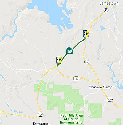
The portion of this route from Route 120/Route 108 junction to the Route 108/Route 49 junction (~ TUO L0.086 to TUO L2.701) is named the "Frank F. Momyer Bypass". It was named by Assembly Concurrent Resolution 112, Chapter 97, in 1986. Frank F. Momyer, General Manager of Pickering Lumber Company, led a widely supported and extensive public effort from 1963 to 1982 to secure construction of the Sonora Bypass, a portion of Route 108 in Tuolumne county.
 From Route 49 south of Jamestown to Route 395 via the vicinity of Sonora and
Long Barn.
From Route 49 south of Jamestown to Route 395 via the vicinity of Sonora and
Long Barn.
Post 1964 Signage HistoryIn 1963, this segment was defined as "From Route 49 to Route 395 via the vicinity of Sonora and Long Barn."
 In 1968, the CHC began discussing proposals for the Sonora Bypass. The 6.1 mi
section, a combination of Route 49 and Route 108, extends from 0.4 mi W of
Mooney Road S of Jamestown to 1.1 mi E of Sonora. The recommended
alternative was designated as A-2. It leaves the alignment of existing
Route 49 0.5 N of Mooney Road to run due N for about a mile. It then turns
NE, recrossing the existing highway N of Jamestown and continuing to near
the SW corner of Sonora. It then jogs E to pass 0.5 mi S of Sonora before
turning generally NE again to join a previously adopted freeway at
existing Route 108 immediately E of Pine Road. The plan is for a scenic
expressway, not a freeway, at this point. Route A-1, the other proposal,
was identical to A-2 from the western start for more than half the total
route distance, splitting a half-mile east of Volponi Acres at Mill Villa
Hill, where A-2 heads S to join up with Route B, near Campo Seco Road.
Route A-1 at Mill Villa Hill jogs S of the existing highway and passes
through the southern edge of Sonora, crossing Washington and Stewart Sts.
on a 40' high overpass. Route B immediately heads S after crossing the
Jacksonville Road generally paralleling Campo Seco Road.
In 1968, the CHC began discussing proposals for the Sonora Bypass. The 6.1 mi
section, a combination of Route 49 and Route 108, extends from 0.4 mi W of
Mooney Road S of Jamestown to 1.1 mi E of Sonora. The recommended
alternative was designated as A-2. It leaves the alignment of existing
Route 49 0.5 N of Mooney Road to run due N for about a mile. It then turns
NE, recrossing the existing highway N of Jamestown and continuing to near
the SW corner of Sonora. It then jogs E to pass 0.5 mi S of Sonora before
turning generally NE again to join a previously adopted freeway at
existing Route 108 immediately E of Pine Road. The plan is for a scenic
expressway, not a freeway, at this point. Route A-1, the other proposal,
was identical to A-2 from the western start for more than half the total
route distance, splitting a half-mile east of Volponi Acres at Mill Villa
Hill, where A-2 heads S to join up with Route B, near Campo Seco Road.
Route A-1 at Mill Villa Hill jogs S of the existing highway and passes
through the southern edge of Sonora, crossing Washington and Stewart Sts.
on a 40' high overpass. Route B immediately heads S after crossing the
Jacksonville Road generally paralleling Campo Seco Road.
(Source: Newspaper Article dated 1/18/1968 via Joel Windmiller,
2/16/2023)
In 2009, SB 532 (Chapter 189, 10/11/2009) changed the origin to "Route 49 south of Jamestown".
Potential Route 108 Freeway
Back in the sixties, Caltrans wanted to upgrade Route 108 to a freeway all the way over the pass. They had detailed plans drawn
up that included a seven mile long tunnel that would start in what is now
the Carson Iceberg Wilderness and terminated near the Marine base. The
proposal was abandoned due to community opposition. Today, Caltrans is
slowly upgrading portions of Route 108 to a freeway using some of the ROW
bought in the sixties.
(Source: Posting by Travis DeCoster)
The freeway plans included a seven mile tunnel which
would have cut through Sonora Pass somewhere along Deadman Creek and
emerge near the Marine Corps Mountain Warfare Training Center. The
Carson-Iceberg Wildness was designated over parts of Stanislaus National
Forest and Humboldt-Toiyabe National Forest as part of California
Wilderness Act of 1984. A key facet of the 1984 California
Wilderness Act was to create roadless wilderness areas. The
boundaries of the Carson-Iceberg Wilderness is plotted directly over
Sonora Pass in what appears to be an attempt to block any potential
freeway/tunnel development.
(Source: Gribblenation Blog "Trans-Sierra Highways; California State Route 108 over Sonora Pass" (Tom Fearer))
Pre 1964 Signage HistoryThis is the original Route 108 as defined in the initial signage of state routes in 1934 (Jct. Route 49 at Sonora to Jct. Route 7 (US 395) at Sonora Junction). It was LRN 13. The portion to Sonora was defined in 1909, the remainder in 1910 or 1901. One record shows the portion from Sonora to Long Barn as having been defined in 1919. This segment has grades as steep as 26%.
A detailed history of what became Route 108 is detailed in the Gribblenation Blog "Trans-Sierra Highways; California State Route 108 over Sonora Pass" (Tom Fearer). The following is summarized from that blog:
The first documented crossing of Sonora Pass was in October of 1841 by way of a course slightly due north of modern Route 108. The first attempted emigrant wagon crossing of Sonora Pass was made in 1852. By 1862 the franchise Sonora-Mono Toll Road was was conceptualized by Andrea Fletcher as a means of connecting the established towns of the western Sierra Nevada Mountains to the mining boom towns of Mono County. By September 1862 a pack trail had been laid out by way of nearby St. Mary's Pass which crossed the Sierra Nevada Mountains at 10,040 feet above sea level. The present route over Sonora Pass by way of Deadman Creek to was surveyed in 1863 and the Sonora-Mono Toll Road was completed by 1865.
Initially funds for the Sonora-Mono Wagon Road were attempted to be raised by way of public bond in 1861. The Sonora-Mono Wagon Road was intended to be a free road but much of the initial funding went into construction over St. Mary's Pass by way of the Clark's Fork of the Stanislaus River when construction began in 1861. Subsequent to the funding failures the Sonora-Mono Wagon Road was granted a toll franchise. The Sonoro-Mono Wagon Road franchise was forfeited in by May of 1864 but by August work had resumed due to funding sources being found in Aurora and Bridgeport. Despite being rerouted onto a better route via Deadman Creek and functionally completed by 1865 to pack trains the Sonora-Mono Wagon Road was not open to wagons until some point in the 1870s. By the time the Sonora-Mono Wagon Road had been built to its intended standard the Esmeralda Mining District was already in decline and had been usurped by better roads that connected to railroad stations in Nevada.
1901 Legislative Chapter 111 made the Sonora-Mono Wagon Road between Long Barn east towards Bridgeport a State Highway. This became LRN 13. During the 1909 First State Highway Bond Act LRN 13 was extended west from Sonora to Salida. The Sonora-Mono State Highway was described as being fit for automotive travel by 1912 and modernized as far as Old Patternson Grade. As noted above, the remaining portion of what was the Sonora-Mono Wagon Road between Sonora and Long Barn was declared a State Highway during 1919 Legislative Chapter 510.
The July/August 1958 California Highways & Public Works refers to Route 108 west to at least Yosemite Junction. It is unclear when Route 108 was extended west from Sonora to Yosemite Junction.
StatusIn October 2004, the CTC considered relinquishment of right of way in the County of Tuolumne, between one kilometer west of Sanguinetti Road and Standard Road (~ TUO R1.255 to TUO R4.514) . Consistent with the Department’s mandatory design standards, access control is retained at specified locations to protect the operational integrity of the superseding Route 108. The County, by freeway agreement dated December 10, 1996, agreed to accept title upon relinquishment by the State and by cooperative agreement dated July 20, 2004, waived the 90-day notice requirement and agreed to accept title upon relinquishment by the State.
In February 2008, the CTC relinquished a portion of the route at Mono Way, between 0.15 miles west of Sanguinetti Road (Loop Road) (~ TUO R1.891 to TUO R2.161) and the easterly city limit line, consisting of superseded highway and collateral facilities.
East Sonora Bypass
 Caltrans plans to build a new 2-lane expressway from Sanuinetti Road to Standard Road near Sonora (Tuo
PM R1.8 to R4.6), bypassing the current alignment. The proposal went
before the CTC in November 2000 for $34.052M. Construction on this has
started. In 2007, the CTC authorized using the Corridor Mobility
Improvement Account (CMIA) to fund Stage 2 of the East Sonora Bypass
($17,233K requested).
Caltrans plans to build a new 2-lane expressway from Sanuinetti Road to Standard Road near Sonora (Tuo
PM R1.8 to R4.6), bypassing the current alignment. The proposal went
before the CTC in November 2000 for $34.052M. Construction on this has
started. In 2007, the CTC authorized using the Corridor Mobility
Improvement Account (CMIA) to fund Stage 2 of the East Sonora Bypass
($17,233K requested).
In October 2009, the CTC considered (but the issue was withdrawn) a project that will construct a 4-lane freeway replacing the existing 2-lane conventional highway currently known as Mono Way; construct interchanges near Fir Drive, Hess Avenue, and Standard Road; construct a new bridge over Sullivan Creek; and construct roadway improvements in the city of Sonora. This project is programmed in the Corridor Mobility Improvement Account and the 2008 State Transportation Improvement Program. Total estimated project cost is $65,920,000, capital and support. Construction is estimated to begin in Fiscal Year 2009-10. The scope as described for the preferred alternative is consistent with the project scope set forth in the approved project baseline agreement.
In February 2010, the CTC approved for consideration of funding a project in Tuolumne County that will construct a 4-lane freeway replacing the existing 2-lane conventional highway currently known as Mono Way; construct interchanges near Fir Drive, Hess Avenue, and Standard Road; construct a new bridge over Sullivan Creek; and construct roadway improvements in the city of Sonora. This project is programmed in the Corridor Mobility Improvement Account and the 2008 State Transportation Improvement Program. The total estimated project cost is $65,920,000 for capital and support. Construction is estimated to begin in Fiscal Year 2009-10. The scope as described for the preferred alternative is consistent with the project scope set forth in the proposed project baseline agreement amendment (CMIA-PA-0910- 018, STIP Amendment 08S-067). A Final Environmental Impact Report (FEIR) has been prepared, as construction activities will occur in habitat areas of several endangered or threatened plant and animal species. The project will also cause impacts to visual, cultural, and riparian resources that will be mitigated by aesthetic treatments, establishing environmentally sensitive areas, and riparian restoration.
In June 2010, the CTC revised the project scope for the East Sonora Bypass project. The baseline scope was to construct a 2-lane expressway from Peaceful Oak Road to Via Este Road, with a full interchange at Peaceful Oak Road. In June 2008, extensive analysis predicted that the baseline budget would be exceeded by $9.4 million (support and capital). A corrective action plan (CAP) committee developed and evaluated various corrective measures to stay within budget. The CAP committee recommended removing the westbound Peaceful Oak Road off-ramp and eastbound Peaceful Oak Road on-ramp from the project scope, and purchasing right of way for a two-lane expressway instead of a four-lane expressway. The deletion of the two ramps were stated as having minimal impact to travelers because there are nearby alternatives. The eastbound Peaceful Oak Road off-ramp and westbound Peaceful Oak Road on-ramp will remain in the project scope. The schedule was also revised; construction is expected to complete in December 2012 or early 2013.
In June 2013, the CTC approved a project that will construct operational and safety improvements on Mono Way from Peaceful Oak Road to Via Este Road. This segment of Mono Way is currently Route 108, but it will be relinquished to Tuolumne County upon completion of the East Sonora Bypass Stage II project (PPNO 0021B); which is currently scheduled for construction completion in March 2014.
In June 2014, the CTC authorized relinquishment of right of way in the county of Tuolumne on Route 108 (Mono Way) from Peaceful Oak Road to realigned Route 108 (East Sonora Bypass) consisting of superseded highway right of way, and along realigned Route 108 (East Sonora Bypass), consisting of collateral facilities. The County, by relinquishment agreement dated June 9, 2010, waived the 90-day notice requirement and agreed to accept title upon relinquishment by the State.
In March 2016, it was reported that the Tuolumne County Transportation Council (Council) had requested that the CTC designate the Route 108 East Sonora Bypass Stage III and Peaceful Oaks Interchange projects as the local highway alternative projects to the rescinded 1968 Route 108 freeway alignment project. On June 18, 1968, the State of California and Tuolumne County entered into a Freeway Agreement for Route 108 from Fir Drive to west of Soulsbeyville Road. For several decades, parcels were acquired along the route for the future freeway project. In 1997, the Council, the Federal Highway Administration and the Department requested that the Commission rescinded the adopted Route 108 freeway alignment in favor of a new bypass route known as the East Sonora Bypass. Sections 14528.7 and 14528.8 of the California Government Code allows a county transportation agency to adopt a resolution to propose alternate highway projects and request the Commission approve allocation of proceeds from the sale of excess right of way along the rescinded route to alternate projects. Commission Resolution HRA 96-8 directs that the proceeds from the sale of excess right of way along the rescinded freeway alignment may be used for purchase of right of way along Stages 2 and 3 of the East Sonora Bypass project once Tuolumne County and Cities Area Planning Council adopts a resolution pursuant to Section 14528.7 of the Government Code. The Council has approved Resolution No.537-16 requesting the Commission approve the Route 108 East Sonora Bypass State III and Peaceful Oaks Interchange projects as alternate highway projects to the rescinded 1968 Route 108 freeway alignment project and request that the Commission allocate proceeds from the sale of excess right of way along the rescinded route to the alternate highway projects.
In June 2017, it was reported that the project to
construct as WB off-ramp and and EB on-ramp at Peaceful Oaks was scheduled
to being in Summer 2019.
(Source: Caltrans District 10 FB Page)
The 2018 STIP, approved at the CTC March 2018 meeting, appears to adjust the allocation for PPNO 3048 Peaceful Oaks Rd Interchange ramps, TUO R4.3/R5.1, from $9.170M to $9.781M. The purpose of this project is to provide on and off ramps to the East Sonora Bypass Stage II project area at a critical interchange to improve accessibility for traffic, particularly emergency vehicles. Originally included in ESBII project but removed due to funding shortfalls. A related project is PPNO 0235 Mono Way op improvements (Rt 108 relinq), which is on former Route 180, TUO R4.0/R6.0, and in East Sonora, along Mono Way (Old Route 108), between Peaceful Oak Road and Via Este Road. Construct operational and safety improvements. Upon completion of East Sonora Bypass Stage II Project, this segment of Route 108/Mono Way will be relinquished to the County. This latter project was delayed to FY22-23.
In January 2020, the CTC approved a resolution that
$7,244,000 be allocated from the Budget Act of 2019, Budget Act Item
2660-301-0042 for construction and $1,669,000 for construction
engineering, and $1,435,000 from Non-Budget Act Item 2660-501-0942 for
PPNO 10-3048, ProjID 1013000104, EA 0Y210: 10-Tuo-108 R4.3/R5.1: Route 108
Peaceful Oaks Road/Route 108 Interchange Ramps. In East
Sonora. At Peaceful Oaks Road. Construct a westbound off-ramp and
eastbound on-ramp. It was noted that projects will be funded from proceeds
of the sale of excess right of way originally purchased for the
now-rescinded alignment for Route 108. The Tuolumne County
Transportation Council is requesting to utilize $1,435,000 in Local
Alternative Improvement Program (LATIP) funds for this allocation.
(Deleted, March 2020) After funding the CONST increase of $807,000, this
fund swap will result in $628,000 being returned to Tuolumne County
shares. In March 2020, this allocation was adjusted to $11,783,000, as
there was no return to Tuolumne County.
(Source: January 2020 CTC Agenda, Agenda Item
2.5c.(9), March 2020 CTC Agenda, Agenda Item 2.5c.(7))
The 2020 STIP, approved at the March 2020 CTC meeting,
makes no changes to the $11,467K programmed for this project. It also
makes no changes in PPNO 0235 Mono Way op improvements (Rt 108 relinq),
which has 3,284K allocated in FY22-23.
(Source: March 2020 CTC Agenda, Item 4.7, 2020 STIP
Adopted 3/25/2020)
In April 2021, it was reported that Caltrans was
scheduled to begin work on the Route 108/Peaceful Oak Interchange in April
2021, adding a westbound off-ramp and eastbound on-ramp. The interchange
takes traffic from the highway to Mono Way and Peaceful Oak Road becomes
Standard Road after it crosses Mono Way. Construction crews will also
widen the overcrossing so that it can accommodate the addition of a
westbound off-ramp. Work is scheduled to conclude in late 2021. The
interchange was built in 2013 with a westbound on-ramp and an eastbound
off-ramp as part of the Route 108 by-pass project. An average of 14,500
vehicles drive through the Peaceful Oak Interchange each day, according to
Caltrans, and that is expected to grow to 16,000 vehicles per day in 2038.
(Source: MyMotherLode.Com, 4/9/2021)
In October 2021, it was reported that an $8.3 million
project to eliminate a circuitous traffic problem in East Sonora by adding
two new freeway ramps at Route 108 and Peaceful Oak Road was 75% complete
and should be finished by 12/31/2021. The Peaceful Oak interchange, first
completed seven years ago in 2014, has two ramps in its current
configuration: one for eastbound motorists to exit Route 108 and join
Peaceful Oak Road, and one for motorists on Peaceful Oak Road to enter
westbound Route 108. An entrance ramp for motorists to get on eastbound
Route 108 from Peaceful Oak Road, and an exit ramp for westbound motorists
to get off Route 108 at Peaceful Oak Road, were subtracted from the $53
million second phase of the East Sonora Bypass project eight years ago, in
order to cut costs. The current project is needed to complete the
interchange at Peaceful Oak Road and to provide the needed on-ramps and
off-ramps to Route 108 for residents and businesses located in the
vicinity of Peaceful Oak Road, Standard Road and Mono Way. Once completed,
the interchange will allow tourists, residents and businesses to more
easily access Peaceful Oak and Mono Way, where a number of residential
neighborhoods and dozens of businesses are located. Currently, motorists
must use the Route 108/Hess Avenue Interchange to the west or the Route 108/Mono Way Interchange to the east. Before the current project began,
the Sonora-based Sierra Mountain Construction was awarded the contract as
the lowest qualified bidder at $7.86 million. Route 108 dates back
to some of the earliest known trade routes in what today is known as
Tuolumne County. Handstones and millingstones dating from 7,000 years ago
were found in the East Sonora Bypass Project area before 2008. Sections of
the current highway still follow routes used by Me-Wuk and Paiute people
before Europeans arrived and named this place California, as well as the
oldest white pioneer-emigrant trails over Sonora Pass and old toll routes
connecting Sonora to Mono County.
(Source: Union Democrat, 10/18/2021; District 10 on FB, 10/21/2021)
In September 2022, it was reported that the new onramp
from Peaceful Oak Road to eastbound Route 108 had opened, completing the
Peaceful Oak Road interchange at a cost of $12.9 million. The contract to
upgrade the interchange, widen the Route 108 overpass bridge, add a
westbound offramp and an eastbound onramp, put a stormwater tunnel under
the asphalt, and build a flood control basin below the interchange, was
awarded to Sierra Mountain Construction of Sonora in July 2020. Before
construction to upgrade the interchange began in April 2021, there was
already a westbound onramp and an eastbound offramp. The project was
delayed about a year. The original intent was to build the eastbound
onramp in 2021. Due to unanticipated project delays, Caltrans suspended
construction during the 2021-22 winter season and resumed when weather
allowed in 2022. The new westbound offramp opened in March 2022. The
ramps that have been added at the Peaceful Oak Road interchange languished
in planning stages for years. They were subtracted from the $53 million
second phase of the East Sonora Bypass project more than eight years ago
to cut costs. A trimmed-down version of the Peaceful Oak Road interchange
was completed in 2014.
(Source: Union Democrat, 9/30/2022)
Relinquishment of the segment in Tuolumne County from PM TUO R6.6 to PM TUO 9.7 (it is unclear if this is the current or a past routing) was up for relinquishement in January 2002.
NamingThe portion of Route 108 located in Tuolumne County is designated the "Tuolumne
County Vietnam Veterans Memorial Highway." It was named in honor of
the veterans from California that served in the Vietnam War. The State of
California has the largest United States veteran population in the nation,
comprised of some 3.3 million armed services veterans who represent 12.3
percent of the nationwide veteran population of nearly 27 million. More
than 350,000 California veterans served in the Vietnam War, which resulted
in 40,000 of them being wounded and 5,822 killed or missing in action,
representing more than 10 percent of the nation's total casualties. In
fact, more California residents died in the Vietnam War than residents of
any other state, and more Californians received the Medal of Honor, the
Bronze Star, and the Purple Heart than veterans of any other state. Named
by Assembly Concurrent Resolution 17, Chaptered 7/8/2003, Chapter 89.
(Image source: MyMotherLoad, 9/18/2019)
The portion of this route from Sonora (~ TUO R0.802) to Long Barn (~ TUO R18.19) has historically been called the "Long Barn to Sonora Road".
 The portion of this route from Sonora (~ TUO R0.802) to US 395 (~ MNO 14.927) was named the "Sonora
and Big Meadows Wagon Road" by Senate Bill 289 in 1901. It was also
named the "Sonora and Mono Wagon Road" by Resolution Chapter 11 in
1901, and extended by Resolution Chapter 510 in 1919.
The portion of this route from Sonora (~ TUO R0.802) to US 395 (~ MNO 14.927) was named the "Sonora
and Big Meadows Wagon Road" by Senate Bill 289 in 1901. It was also
named the "Sonora and Mono Wagon Road" by Resolution Chapter 11 in
1901, and extended by Resolution Chapter 510 in 1919.
(Image source: Tuolumne County Historical Society)
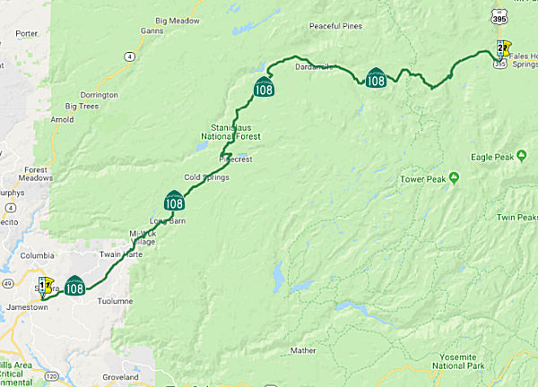
 Sonora Pass (~ MNO 0.027) is named for the community of Sonora, which began as a camp
established in the summer of 1848 by Mexican miners from the state of
Sonora. The town became the county seat February 18, 1850. It is the
second highest Sierra crossing, only 321 feet lower than Tioga to the
south. A sign at the pass says this: “The Bartleson-Bidwell party,
with mules, horses and oxen, made the first crossing on October 18,
1841.”
Sonora Pass (~ MNO 0.027) is named for the community of Sonora, which began as a camp
established in the summer of 1848 by Mexican miners from the state of
Sonora. The town became the county seat February 18, 1850. It is the
second highest Sierra crossing, only 321 feet lower than Tioga to the
south. A sign at the pass says this: “The Bartleson-Bidwell party,
with mules, horses and oxen, made the first crossing on October 18,
1841.”
(Sources: Bill Sanford "Getting out of the Central Valley: Highway
passes to the east" (emailed draft 10/1/2010); Image source: Wikiedia)
Named StructuresBridge 32-0008 (now 32-0067, TUO R002.78), at Sullivan Creek in Tuolumne county, is named the "Leslie G. Delbon Memorial Bridge". It was built in 1991, and named by Senate Concurrent Resolution 48, Chapter 105, the same year. Leslie G. Delbon, (d. 1990), as Manager and Chief Engineer of Tuolumne Water District number 2, oversaw the development and operation of a water, sewer and wastewater treatment system that serves a significant portion of the county.
 Business Routes
 Scenic Route
[SHC 263.6] Entire portion.
 Freeway
[SHC 253.1] Entire route. Added to the Freeway and Expressway system in 1959.
 Interregional Route
[SHC 164.15] From Route 132 in Modesto to Route 120 east of Oakdale, and between Route 120 at Yosemite Junction and Route 395.
Note: The portion from Route 132 in Modesto to Route 120 east of Oakdale was added by SB SB 532 (Chapter 189, 10/11/2009).
 Other WWW Links
 Statistics
Overall statistics for Route 108:
 Pre-1964 Legislative Route
In 1933, Chapter 767 defined the route from [LRN 5] near Mission San Jose to [LRN 5] near Livermore. In 1935, defined LRN 108 as part of the highway code with that definition ([LRN 5] near Mission San Jose to [LRN 5] near Livermore).
In 1959, Chapter 1062 extended the route to terminate at "[LRN 75] near Brentwood".
This route ran from Route 9 (present-day Route 238) near Mission San Jose to Route 4 near Brentwood, and is roughly present-day I-680 between Route 238 and Route 84, and Route 84 from the I-680/Route 84 junction to Route 4.
© 1996-2020 Daniel P. Faigin.
Maintained by: Daniel P. Faigin
<webmaster@cahighways.org>.
 Route 107
 Route 109