
 California Highways:
Click here for a key to the symbols used. An explanation of acronyms may be found at the bottom of the page.
 Routing
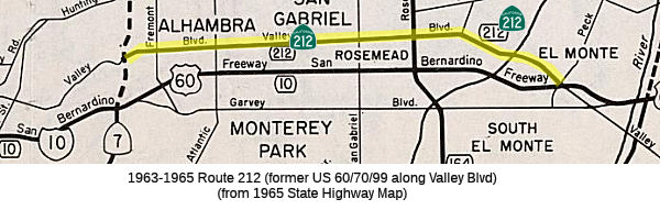 No current routing.
 Post 1964 Signage History
 In 1963, Route 212 was defined to run from the east city limits of
Los Angeles to Route 10 near El Monte. This routing was deleted in 1965 by
Chapter 1372.
 Pre 1964 Signage History
The history of the 1964-1965 routing of Route 212 begins with the extension of LRN 26 to Los Angeles, when a segment that ran from [LRN 26] near Colton via Pomona to Los Angeles was added. Specifically, segment (i) of Chapter 82 defined it as "[LRN 26] near Colton via Pomona to Los Angeles". The April 1931 CHPW also discussed the proposal for the route, which referred to it as "a highway from Los Angeles to a connection with [LRN 26] E of Colton". The confusing part here is that the extension did not start in Los Angeles; rather, it started from the eastern border of Los Angeles (roughly the LA River, just E of Eastern Avenue), near Ramona and Garvey. The routing utilized Garvey (much of which was later subsumed by I-10) and Holt Avenue. The rationale for the extension was to provide a mid-point route between LRN 9 (US 66) to the north, and the eventual US 60 routing to the south. In 1933, the route was extended from "Los Angeles (Aliso Street) to [LRN 26] near Monterey Park via Ramona Blvd", which completed LRN 26 into downtown Los Angeles. This was the eventual Ramona Expressway that became the San Bernardino Freeway (I-10).
During this time period, US 60 and US 70 were extended to downtown LA. US 60 was extended in 1933. In 1934, US 99 was moved onto LRN 26, and US 70
was extended to Los Angeles.
(Source: Gribblenation Blog (Tom Fearer), "Former California State Route 212", July 2022)
It is during this time that the future Route 212 routing along Valley
Blvd comes into the picture. The 1934 Division of Highways City Insert
implies US 60/LRN 26 followed an interim alignment from downtown Los
Angeles eastward following Macy Street, Mission Street, Alhambra Avenue
and Valley towards Pomona. The planned Ramona Expressway can be seen
as a dotted line connecting Macy Street directly to Garvey Avenue. But by
1935, things changed again. The 1935 Division of Highways Map of downtown
Los Angeles shows US 99/US 60/US 70 (solid red line) following an interim
alignment of LRN 26 east via Macy Street, Brooklyn Avenue and Mednik
Avenue towards the completed segment of the Ramona Boulevard. US 99/US 60/US 70 on LRN 26 are shown transitioning from the Ramona
Expressway onto Garvey Avenue in Monterey Park. Valley Boulevard is
shown at this point to no longer be a State maintained roadway.
Ramona Blvd was completed in May 1935.
(Source: Gribblenation Blog (Tom Fearer), "Former California State Route 212", July 2022)
In 1935, the Legislature added Valley Boulevard back to the State Highway
System as part of Legislative Chapter 626, Section 603. Initially
Chapter 626/Section 603 did not add Valley Boulevard and defined it as
follows: "There is hereby added to the state highway system a new route or
portion of route from the east city limits of Los Angeles on Valley
Boulevard to LRN 26 near El Monte via Valley Boulevard and Pomona
Boulevard." This was shown on state maps as part of LRN 77. This
corresponded to the
pre-freeway surface street routing of US 60/US 70/US 99 along Valley Blvd.
(Source: Gribblenation Blog (Tom Fearer), "Former California State Route 212", July 2022)
Note that the 1935 segment only runs as far E as the intersection of Valley and Garvey. It is discontiguous from the rest of LRN 77. In 1937, Chapter 841 repealed Section 603, and added the Valley Blvd segment to [LRN 77] as segment (a) instead, numbering the 1935 segment (“Pomona to San Diego via Temecula”) as (b).
In 1953, Chapter 237 changed the definition of (a) to drop the specific routings on Valley Boulevard and Pomona Boulevard: "From the E city limit of Los Angeles to LRN 26 near El Monte".
 Other WWW Links
 Pre-1964 Legislative Route
In 1947 (1st Ex Session), Chapter 13 defined LRN 212 as “the Nevada-California State Line in the southern portion of Pahrump Valley to [LRN 23] near Freeman”
In 1955, Chapter 76 reiterated the definition and indicated that Section 600 was applicable to the route. Later that year, Chapter 1488 removed the language relating to Section 600.
This route is present-day Route 178.
© 1996-2020 Daniel P. Faigin.
Maintained by: Daniel P. Faigin
<webmaster@cahighways.org>.
 Route 211
 Route 213