
 California Highways:
Click here for a key to the symbols used. An explanation of acronyms may be found at the bottom of the page.
 Routing
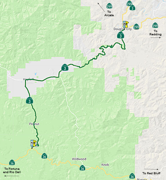 From Route 36 near Peanut to Route 299 near Douglas City.
 Post 1964 Signage History
This was added to the state highway system in 1963 (Chapter 385). CHPW noted: "Weaverville—Scott Mountain Road (Federal Aid Secondary County Road 1089) in Trinity County, a route between US 299 at Weaverville and US 99 at Yreka, was included in the state scenic highway system enacted by the Legislature in 1963. It will be known as State Route 3." TRI L0.086/TRI 30.555.
 Pre 1964 Signage History
The portion of this route in the vicinity of Peanut was added to the state highway system in 1907 as LRN 35. It was part of "An act to provide for the survey, location and construction of a state highway connecting the present county road systems of any one or all of the counties of Trinity, Tehama and Shasta with the road system of Humboldt County...", approved March 23, 1907, chapter 117. It was extended to Route 299 near Douglas City in 1933. It was not signed as part of the original set of signed state routes in 1934, and appears not to have had a signed route number until it was signed as Route 3 in 1964. However, the "Old Route 36" joins Route 3 in Peanut.
In the Gribblenation Blog "California State Route 3", Tom Fearer provides the following additional history. See the blog for more details, links to maps, and much more. The following is excerpted from that blog:
The first segment of State Highway that would be later partially adopted as part of the current Route 3 was a route between the communities of Kuntz (now Mad River) and Peanut (approximately) by way of 1907 Legislative Chapter 117. In time this segment of highway between Kuntz and Peanut would come to be known as LRN 35. The 1909 First State Highway Bond Act added two future segments of State Highway which would become part of Route 3: (1) LRN 20 from Douglas City north to Weaverville, and (2) LRN 3 through Yreka near what is now Moonlit Oaks Avenue north on Front Jones Road and Main Street to Montague Road. This segment of LRN 3 would become part of the Pacific Highway in 1913 and US 99 in November 1926. In 1933, LRN 35 was extended north from Peanut to LRN 20 in Douglas City. 1933 also saw LRN 82 added by as a new State Highway from Etna Mills north to Montague. The new segments of LRN 35 and LRN 82 later become components of future Route 3. The definition of LRN 82 was extended from Etna Mills south to a new origin point at LRN 20 in Weaverville via 1959 Legislative Chapter 1062.
Note that none of this appears to have been signed. Signed Route 3 along this corridor did not appear until 1964.
 Naming
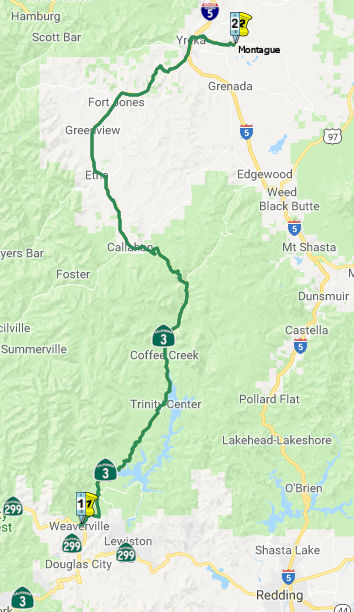 From Route 299 near Weaverville
to Montague via Main Street in Yreka.
From Route 299 near Weaverville
to Montague via Main Street in Yreka.
Post 1964 Signage HistoryIn 1963, Chapter 385 established this as two segments: (b) Route 299 near Weaverville to Route 5 near Yreka. (c) Route 5 near Yreka to Montague.
In 1974, Chapter 123 combined segments (b) and (c) to make this continguous.
Note that Route 3 continues as County Sign Route A28 past Montague.
Pre 1964 Signage History The small portion of this route in Yreka, between I-5 and Route 263,
was originally part of US 99, defined in 1910 as part of LRN 3. This
portion of this segment from Route 5 near Etna to Montague was defined as
part of the state highway system in 1933 as LRN 82. Its signage in 1934 is
unknown. The remainder of this segment, from Weaverville to Route 5 near
Etna, was added to LRN 82 in 1959.
The Yreka-Montague section of Route 3 was intended to provide a
state-maintained route from the Siskiyou county seat to the original SP RR
depot in Montague—it was considered that the Dept. of Highways would
tend to keep the road plowed in winter, more so than the county. SP
maintained a local passenger train from Dunsmuir over the top of Siskiyou
Summit to Grants Pass until the early 1960's; a similar train traversed
the north end of the line from Ashland to Eugene; both "overlapped" in the
Rogue River valley. Each connected to through CA-Portland service at
Dunsmuir and Eugene respectively. So for about 70+ years, a
passenger train made a Montague station stop daily in each direction.
(Source: Scott Parker on AARoads, "Re: CA 3", 12/11/2020)
 Status
In October 2017, the CTC authorized vacation of right of way in the county of Trinity along Route 3, 0.1 miles east of Route 299 (003 TRI 30.9), consisting of highway right of way no longer needed for State highway purposes.
Weaverville Washout
In March 2016, it was reported that a stretch of
pavement several car-lengths long was washed away on Route 3 north of
Weaverville (apx 003 TRI 30.932) along with the hillside. Caltrans said
that contractors would survey the damage and that some traffic could
resume on the road within eight weeks. Full repairs could take two to
three months.
(Source: LA Times, 3/16/2016)
In May 2016, it was reported that the washed-out
stretch of Route 3 is nearly complete. Construction isn't complete, but
motorists can drive on an unpaved surface subject to traffic control, the
California Department of Transportation has announced. The traffic control
will be in place around the clock, seven days a week until construction by
Tullis Inc. is complete, Caltrans said. All vehicles will be allowed on
the rural state highway through the Shasta-Trinity National Forest. Once
traffic is flowing, the alternate route that's been available since
mid-March at Trinity Dam and Slate Creek will not be maintained by
Caltrans, the agency said. Caltrans said the reconstruction of Route 3 is
expected to be finished by early summer 2016.
(Source: Redding Record Searchlight, 5/26/2016)
Improvements at Tom Bell Road (~ TRI 31.935)
The 2018 STIP, approved at the CTC March 2018 meeting, appears to allocate $700K in FY19-20 for construction for PPNO 3716 Weaverville, Tom Bell Rd, left turn lanes (~ TRI 31.935).
The 2020 STIP, approaved at the March 2020 CTC meeting,
continues the programmed allocation of $700K for this project.
(Source: March 2020 CTC Agenda, Item 4.7, 2020 STIP
Adopted 3/25/2020)
Swift Creek Bridge № 05-0059 02-Trinity-3 58.7/61.9
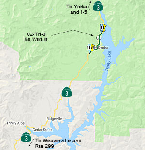 Thefollowing
project was included in the final adopted 2018 SHOPP in March 2018: PPNO 3485. 02-Trinity-3 58.7/61.9. Route 3
Near Trinity Center, from north of Preacher Meadows Road to north of El
Dorado Way. Replace Swift Creek Bridge № 05-0059. Begin Con:
12/1/2020. Total Project Cost: $14,247.
Thefollowing
project was included in the final adopted 2018 SHOPP in March 2018: PPNO 3485. 02-Trinity-3 58.7/61.9. Route 3
Near Trinity Center, from north of Preacher Meadows Road to north of El
Dorado Way. Replace Swift Creek Bridge № 05-0059. Begin Con:
12/1/2020. Total Project Cost: $14,247.
In January 2019, the CTC approved for future consideration of funding 02-Tri-3, PM 58.7/60.7 Swift Creek Bridge Replacement Project. The proposed project is located on Route 3 near the community of Trinity Center in Trinity County. The project proposes to replace the Swift Creek Bridge (No. 05-0059). The purpose of this project is to address the structural deficiencies and scour issues as the deck, abutment, piers and wingwall exhibit significant deterioration. The project proposes to reduce the need for continued maintenance and repairs while restoring the long-term reliability of the Swift Creek Bridge. The estimated total cost for the proposed project is $16.9 million. The proposed project is fully funded in the 2018 SHOPP for an estimated $14.3 million which includes Construction (capital and support) and Right-of-Way (capital and support). Construction is estimated to begin in fiscal year 2020-21. The scope, as described for the preferred alternative, is consistent with the project scope programmed by the Commission in the 2018 SHOPP.
The project will result in less than significant
impacts to the environment after mitigation. The following resource area
may be impacted by the project: biological resources. Avoidance and
minimization measures will reduce any potential effects on the
environment. These measures include, but are not limited to, in-stream
work will be conducted during the dry season from June 15 to October 15,
environmentally sensitive areas will be fenced, exclusion fencing will be
installed to protect the foothill yellow-legged frog from construction
activities, and the site will be surveyed daily for potential conflicts
with riparian habitat or the foothill yellow legged frog. As a result, an
MND was completed for this project.
(Source: January 2019 CTC Minutes, Agenda Item
2.2c(1))
In January 2019, the CTC approved the following support
allocation: Route 3 Near Trinity Center, from north of Preacher Meadows
Road to north of El Dorado Way. Replace Swift Creek Bridge №
05-0059. Concurrent consideration of funding under Resolution E-19-02;
January 2019. Allocation: PS&E $1,680,000 R/W Sup $119,000.
(Source: January 2019 CTC Minutes, Agenda Item
2.5b.(2b) Item 5)
In May 2019, the CTC approved the following SHOPP
Amendment: 02-Tri-3 58.7/61.9 58.7/60.7 PPNO 3485.
ProjID 0212000073. On Route 3 Near Trinity Center, from 1.3 miles
south to 0.7 mile north of Swift Creek Bridge north of
Preacher Meadows Road to north of El Dorado Way. Replace Swift
Creek Bridge № 05-0059. Note: Update postmiles and decrease R/W
capital as mitigation costs and right of way impacts are reduced by
eliminating a second borrow site. Additional construction capital is
needed as the road profile needs to be raised by two feet to prevent
overtopping. This necessitates increased bridge height, additional
embankment, and larger drainage facilities. Increased cost of steel and
precast members has also resulted in increase of construction capital.
Updated est. cost: $17,041K.
(Source: May 2019 CTC Agenda Item 2.1a.(1) Amend
Item 17)
In October 2020, the CTC approved the following
construction allocation: $16,189,000 for Trinity 02-Tri-3 PM 58.7/60.7
PPNO 02-3485 ProjID 0212000073 EA 4F220. Route 3 near Trinity Center, from
1.3 miles south to 0.7 mile north of Swift Creek Bridge № 05-0059.
Outcome/Output: Replace deteriorating bridge with precast concrete girder
bridge on a raised profile with 12 foot wide lanes and standard shoulders,
upgrade bridge rail, and improve horizontal alignment. Con Eng:
$2,090,000; Const $11,490,000. (CEQA - MND, 12/11/2018; Re-validation
6/26/2020) (NEPA - CE, 12/11/2018; Re-validation 6/26/2020) (Future
consideration of funding approved under Resolution E-19-02; January 2019.)
(Source: October 2020 CTC Agenda, Agenda Item
2.5b.(1) #1)
In May 2023, it was reported that crews from McCullough
Construction Inc. are 90% completed with the $14 million replacement of
the Swift Creek Bridge on Route 3 in Trinity County. The work is
anticipated to be complete in late spring or summer 2023. The initiative
is replacing the existing bridge, a 168-ft. long, two-span, reinforced
concrete T-girder bridge with seat type abutments and a pier wall
supported on spread footings with one-lane in each direction. The original
bridge was constructed in 1957. The new structure is a two-span,
precast/prestressed, wide flange concrete girder bridge with the same
number of lanes and two standard 8-ft. wide shoulders. California ST-70S
bridge rail that is see through and side mounted is being installed.
General roadway paving improvements along the route are being executed:
standard width 8-ft.-wide shoulders; increased horizontal curve radius
from 350 ft. to 587 ft.; and a raised roadway profile. The old bridge is
being replaced with a new bridge, on a new alignment. Additionally, a
bottomless large arched steel culvert was placed to improve fish passage
at Rancheria Creek. Due to permitting restrictions in Swift Creek,
demolition of the old bridge will be delayed until mid-August. Conclusion
of the demolition, and the project, should occur prior to mid-October. The
original plan was to have completed the demolition and been done in winter
2022, however due to delays in getting fiber optic lines moved from the
old to new bridge, and the wetter earlier and heavier weather we had this
past winter, there were delays. Equipment utilized for the construction
includes cranes, excavators, dozers, loaders, rollers, pavers and other
standard equipment. McCullough purchases and rents equipment from local
and regional dealerships.
(Source: Construction Equipment Guide, 5/30/2023)
In August 2023, the CTC approved a request for an
additional $850,000 in Construction Support for the SHOPP Bridge
Rehabilitation and Replacement project on Route 3, in Trinity County, to
complete the construction contract. This project (02-Tri-3 58.7/60.7, PPNO
02-3485; ProjID 0212000073; EA 4F220) is located on Route 3, near Trinity
Center, at Swift Creek Bridge № 05-0059, in Trinity County.
The project will replace the bridge. In April 2016, the project was
programmed for $2,090,000 in Construction Support in the SHOPP for
allocation in Fiscal Year 2019-20. In October 2020, the project was
allocated for $2,500,000 in Construction Support. In February 2021, the
project was awarded for the construction phase. In May 2021,
construction began with 250 working days. In September 2022, the
project received G-12 funds in the amount of $300,000. There are no
remaining funds in Construction Support and the project was placed in and
remains in wither suspension until further coordination with the
contractor. The project is 90 percent complete with 10 working days
remaining; an additional 30 working days are proposed to be added through
a contractor change order. The planned Construction Contract
Acceptance is scheduled for December 2023.
(Source: August 2023 CTC Agenda, Agenda Item 2.5e.(3))
The project realized cost increases due to delays
from recent wildfires, heavy precipitation, and utility relocations. As a
result, task orders were required for consultant staff to perform
inspection work, and the additional inspection work required an additional
construction season. During construction, the project was affected by two
wildfires that delayed construction and added an additional construction
season. Work on the project was delayed as the Department’s
construction support staff were redirected to work on emergency projects
related to these wildfires. In addition, the project encountered
additional delays while coordinating with the utility owner to
relocate the existing fiber optic line from the old structure to the new
one. The delays associated with the relocation pushed the schedule
past the construction window, and contributed to the need for an
additional construction season. As a result, task orders were issued
to consultants to help perform construction administration, inspection,
and assistant resident engineer functions. These consultants were
utilized more than anticipated and were relied upon to perform some
laboratory testing services and stormwater permit compliance during the
unanticipated heavy precipitation that occurred during the 2022-23 months.
While G-12 funds were obtained in September 2022 to complete construction
due to the delays, it was not anticipated at the time that the project
would go into winter suspension. These task orders resulted in an
increase of $430,000 over the G-12 funding received for the project. As a
result of the delays to the project, additional support resources are
needed to complete the remaining bridge and demolition work. This
includes demolition of the existing bridge, inspection of finish work
related to the new bridge, environmental compliance and mitigation work,
and construction closeout activities. These remaining activities
amount to $420,000 in support.
(Source: August 2023 CTC Agenda, Agenda Item 2.5e.(3))
Moffett Creek Bridge (02-Sis-03 38.0/38.6)
") In October 2015, the CTC authorized the following long lead SHOPP funding:
2-Sis-3 38.0/38.6 Route 3 North of Fort Jones, from 0.3 mile south to 0.3
mile north of West Moffett Creek Road at Moffett Creek Bridge №
02-0042. Bridge replacement. PAED: 09/06/2019 R/W: 07/31/2020 RTL:
08/28/2020 CCA: 01/12/2024 Costs: $237K (R/W); $3,920K (C). Completion
FY20/21. Support costs: PA & ED $1,340K; PS & E $700K; RW Sup
$80K; Con Sup $1,540K; Total $3,660K.
In October 2015, the CTC authorized the following long lead SHOPP funding:
2-Sis-3 38.0/38.6 Route 3 North of Fort Jones, from 0.3 mile south to 0.3
mile north of West Moffett Creek Road at Moffett Creek Bridge №
02-0042. Bridge replacement. PAED: 09/06/2019 R/W: 07/31/2020 RTL:
08/28/2020 CCA: 01/12/2024 Costs: $237K (R/W); $3,920K (C). Completion
FY20/21. Support costs: PA & ED $1,340K; PS & E $700K; RW Sup
$80K; Con Sup $1,540K; Total $3,660K.
The following project was included in the final adopted 2018 SHOPP in March 2018: PPNO 3546. 02-Siskiyou-5 38.0/38.6. On Route 3 North of Fort Jones, from 0.3 mile south to 0.3 mile north of West Moffett Creek Road at Moffett Creek Bridge № 02-0042. Bridge replacement. Begin Con: 2/26/2021. Total Project Cost: $7,817K.
In October 2019, the CTC had on its agenda approval of
the following project for future consideration of funding: 02-Sis-3, PM
38.0/38.6 Route 3 in Siskiyou County. Replace an existing bridge on Route 3 near the town of Fort Jones in Siskiyou County. (PPNO 3546). This
project is located on Route 3 near the town of Fort Jones in Siskiyou
County. This project proposes to replace the Lower Moffett Creek Bridge
(No. 02-0042). The purpose of the project is to maintain mobility and
connectivity on Route 3 near the town of Fort Jones in Siskiyou County
without load restrictions. Work activities would include demolition of the
existing bridge, construction of a new bridge on the current alignment,
installation of new guardrails and bridge railing, reconstruction of
approach pavement and shoulders to conform to the new bridge, and the
improvement of road connections within the project limits. This project is
fully funded and is programmed in the 2018 State Highway Operation
Protection Program (SHOPP) for an estimated $7.8 million which includes
Construction (capital and support) and Right-of-Way (capital and support).
Construction is estimated to begin Fiscal Year 2020-21. The scope, as
described for the preferred alternative, is consistent with the project
scope programmed by the Commission in the 2018 SHOPP.
(Source: October 2019 CTC Agenda, Agenda Item
2.2c.(1))
In October 2019, the CTC approved the following
pre-construction allocation: 02-Sis-3 38.0/38.6. PPNO 3546 Proj ID
0214000013 EA 4G440. Route 3 North of Fort Jones, from 0.3 mile south to
0.3 mile north of West Moffett Creek Road at Moffett Creek Bridge №
02-0042. Bridge replacement. (Concurrent consideration of funding under
Resolution E-19-81; October 2019.) PS&E $700,000 R/W Sup $80,000
(Source: October 2019 CTC Agenda, Agenda Item
2.5b.(2b) #3)
The 2020 SHOPP, approved in May 2020, included the
following Bridge Preservation item of interest (carried over from the 2018
SHOPP): 02-Siskiyou-3 PM 38.0/38.6 PPNO 3546 Proj ID 0214000013 EA 4G440.
Route 3 North of Fort Jones, from 0.3 mile south to 0.3 mile north of West
Moffett Creek Road at Moffett Creek Bridge № 02-0042. Bridge
replacement. Programmed in FY20-21, with construction scheduled to start
at the end of February 2021. Total project cost is $10,887K, with $7,227K
being capital (const and right of way) and $3,660K being support
(engineering, environmental, etc.).
(Source: 2020 Approved SHOPP a/o May 2020)
In January 2021, the CTC approved the following
allocation: #2. $7,286,000. Siskiyou 02-Sis-3 38.0/38.6. PPNO 02-3546
ProjID 0214000013 EA 4G440. Route 3 Near Fort Jones, from 0.3 mile south
to 0.3 mile north of West Moffett Creek Road at Moffett Creek Bridge
№ 02-0042. Outcome/Output: Replace deteriorating
bridge with a single span concrete box girder bridge, upgrade bridge rails
and provide standard width lanes and shoulders, and upgrade guardrail and
end treatments. The allocation is divided into Con Eng $1,540,000; Const
$6,990,000. The difference from what was allocated appears to be due
to savings in earlier phases. (Future consideration of funding approved
under Resolution E-19-81; October 2019)
(Source: January 2021 CTC Agenda, Agenda Item
2.5b.(1) #2)
In November 2021, it was reported that Steelhead
Constructors has started work on the $10.2 million Moffett Creek Bridge
Replacement Project. The project is taking place 6 mi. north of the city
of Fort Jones (Siskiyou County) in Scott Valley. The bridge is along Route 3. In addition to the complete bridge replacement, crews also are widening
the roadway shoulders to conform with the new bridge width, and this
included an upgrade to the bridge approach railing to bring it into
compliance with current safety standards. Crews also will be responsible
for placing an asphalt overlay along the detour route. The old concrete
T-beam bridge was 96-ft. long and one lane each direction. The new bridge
is on the same alignment as the old one, based on a precast concrete box
girder design, and will be 100-ft. long with one lane each direction when
completed. The new bridge will be opened to traffic by December 2021. See
the source article link for all the details on the construction process.
(Source: Construction Equipment Guide, 11/16/2021)
Naming The portion of Route 3 between Callahan at SIS 8.8 and Etna at SIS 19.7 in the
County of Siskiyou is named the "Crynthia and Erling Hjertager Memorial
Highway". This segment was named in honor of Crynthia and Erling
Hjertager, two exceptionally generous individuals who continuously and
unreservedly contributed to the community of Scott Valley over a period of
fifty years. They donated their time and capital to the community of Scott
Valley in times of dire need and emergency. For example, Erling Hjertager
was known to personally fly individuals, at a moments notice and free of
charge, to San Francisco that were in need of medical attention. Erling
Hjertager was a successful entrepreneur and owner of a sawmill that
employed many in the County of Siskiyou and provided an incredible amount
of lumber to the World War II effort. Both Crynthia and Erling Hjertager
were true community leaders that headed the Boy Scouts, sponsored local
basketball teams, lead the Masonic society, anonymously donated to
numerous charities, and delivered wood to the elderly during the winter
season. Named by Assembly Concurrent Resolution (ACR) 108, Resolution
Chapter 84, on 07/11/2006.
The portion of Route 3 between Callahan at SIS 8.8 and Etna at SIS 19.7 in the
County of Siskiyou is named the "Crynthia and Erling Hjertager Memorial
Highway". This segment was named in honor of Crynthia and Erling
Hjertager, two exceptionally generous individuals who continuously and
unreservedly contributed to the community of Scott Valley over a period of
fifty years. They donated their time and capital to the community of Scott
Valley in times of dire need and emergency. For example, Erling Hjertager
was known to personally fly individuals, at a moments notice and free of
charge, to San Francisco that were in need of medical attention. Erling
Hjertager was a successful entrepreneur and owner of a sawmill that
employed many in the County of Siskiyou and provided an incredible amount
of lumber to the World War II effort. Both Crynthia and Erling Hjertager
were true community leaders that headed the Boy Scouts, sponsored local
basketball teams, lead the Masonic society, anonymously donated to
numerous charities, and delivered wood to the elderly during the winter
season. Named by Assembly Concurrent Resolution (ACR) 108, Resolution
Chapter 84, on 07/11/2006.
(Image source: "2006 Named Freeways, Highways, Structures and Other Appurtenances In California", Photo by: Raymond Hjertager)
 Named Structures
The Wildcat Creek Bridge on Route 3 in the County of Siskiyou (003 SIS 9.75) is officially named the "Erling Hjertager Memorial Bridge". This bridge was named in honor of Erling Hjertager, an exceptionally generous individual who continuously and unreservedly contributed to the community of Scott Valley over a period of fifty years. He donated their time and capital to the community of Scott Valley in times of dire need and emergency. Erling Hjertager was known to personally fly individuals, at a moments notice and free of charge, to San Francisco that were in need of medical attention. Erling Hjertager was a successful entrepreneur and owner of a sawmill that employed many in the County of Siskiyou and provided an incredible amount of lumber to the World War II effort. Erling Hjertager was a true community leader that headed the Boy Scouts, sponsored local basketball teams, lead the Masonic society, anonymously donated to numerous charities, and delivered wood to the elderly during the winter season. Named by Assembly Concurrent Resolution (ACR) 108, Resolution Chapter 84, on 07/11/2006.
 Other WWW Links
 Freeway
[SHC 253.2] From Route 299 near Weaverville to Route 5 near Yreka. Added to the Freeway and Expressway system in 1959 by Chapter 1062.
 Scenic Route
[SHC 263.2] Entire route.
 Interstate Submissions
The designation I-3 was proposed in November 1957 for what is now I-280. In April 1958, I-3 was proposed again for what is now I-405. Neither was accepted by AASHTO.
 Statistics
Overall statistics for Route 3:
Pre 1964 Signage History In the initial 1934 state signage, Route 3 was the routing that is
present-day Route 1 from US 101 near El Rio to US 101 (present-day I-5)
near San Juan Capestrano (LRN 60). This was re-signed as US 101A in 1935,
and was later renumbered as Route 1.
In the initial 1934 state signage, Route 3 was the routing that is
present-day Route 1 from US 101 near El Rio to US 101 (present-day I-5)
near San Juan Capestrano (LRN 60). This was re-signed as US 101A in 1935,
and was later renumbered as Route 1.
 Pre-1964 Legislative Route
LRN 3 was defined as part of the 1909 First Bond Issue to run from Sacramento to the Oregon Line.
By 1935, it was codified into the SHC as:
[LRN 3] is from Sacramento to the Oregon State Line.
The bridge which extends across the Yuba River from the city of Marysville on the north to the State Highway on the south, and the bridge which extends across the Feather River between the city of Marysville and the city of Yuba City, are parts of [LRN 3] and are under the supervision and control of the department which shall maintain them. In the case of the bridge and highway thereon across the Feather River, the State assumes only that obligation of maintenance imposed upon the counties of Yuba and Sutter under any contract existing on August 14, 1931, with any railroad company for maintenance thereof. The department acting through the comission may, by resolution of the commission, at such time as the department finds it necessary and proper, relinquish the State's interest to the counties of Yuba and Sutter and thereupon the State's supervision and control over such bridge and highway thereon shall entirely revest in those counties.
The route was considered a primary route in its entirety.
In 1949, the text about the bridges was removed by Chapters 909 and 1467, but the routing was changed to indicate the route ran "from Sacramento to the Oregon State line via Yreka".
This route was signed as US 99E, US 99, and as Route 65 (between Roseville and Lincoln). Post-1964 signage is as Route 256 (1964-1994), Route 65, Route 99, and I-5. Portions were cosigned with US 40 (between Sacramento and Roseville). A small portion in Yreka between I-5 and Route 263 was later redesignated as part of Route 3.
© 1996-2020 Daniel P. Faigin.
Maintained by: Daniel P. Faigin
<webmaster@cahighways.org>.
 Route 2
 Route 4