
 California Highways:
Click here for a key to the symbols used. An explanation of acronyms may be found at the bottom of the page.
 Routing
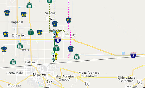 From the northerly boundary of the Federal Port of Entry
near Calexico to Route 8 near El Centro.
From the northerly boundary of the Federal Port of Entry
near Calexico to Route 8 near El Centro.
 Post 1964 Signage History
1964-1982 Route 7 - Long Beach Freeway

 ▸ In 1963, Route 7 was defined as "from Route 11 [Present-Day Route 110] in San Pedro to Route 210 in Pasadena via Long
Beach and including a bridge, with at least four lanes, from San Pedro at
or near Boschke Slough to Terminal Island."
▸ In 1963, Route 7 was defined as "from Route 11 [Present-Day Route 110] in San Pedro to Route 210 in Pasadena via Long
Beach and including a bridge, with at least four lanes, from San Pedro at
or near Boschke Slough to Terminal Island."
▸ In 1965 the southern end was truncated by Chapter 1372, transferring the San Pedro portion and bridge to Route 47. This left the route definition as "from Route 1 to Route 210 in Pasadena."
On October 19, 1965, construction broke ground on the Gerald Desmond
Bridge along Seaside Boulevard in Long Beach. The structure was a
direct replacement for the 1944 Terminal Island Pontoon Bridge. The
intent of the Gerald Desmond Bridge was to provide a direct link for
Terminal Island traffic to reach the Long Beach Freeway. The Gerald
Desmond Bridge was completed during June 1968. The Gerald Desmond
Bridge was a five lane through arch span which was 5,134 feet long.
(Source: Gribblenation Blog (Tom Fearer), "Interstate 710", 8/26/2023)
▸ In 1982, Chapter 914 extended the definition to include that portion of the freeway between Route 1 and the northern end of Harbor Scenic Drive, that portion of Harbor Scenic Drive to Ocean Boulevard, that portion of Ocean Boulevard west of its intersection with Harbor Scenic Drive to its junction with Seaside Boulevard, and that portion of Seaside Boulevard from the junction with Ocean Boulevard to Route 47. It was noted that this extension didn't become operative unless the commission approves a financial plan.
▸ In 1984, Chapter 409 deleted Route 7, and moved the definition to Route 710, which was defined as "Route 1 to Route 210 in Pasadena." The additional conditions regarding the Harbor Scenic Drive and the financial conditions were also transferred. This reflected the approval of Route 7 as 139(a) non-chargable interstate for continuity of numbering with Route 10 (I-10), off of which it spurs. [One might argue that it could have been considered a loop route around the center of the city, and as such, would more appropriately have an (even digit)05 number. However, all of the (even-digit)05 numbers are in use: I-205 (Sacramento), I-405 (Los Angeles), I-605 (Los Angeles), I-805 (San Diego).]
The legislative description of Route 710 transferred from Route 7 still included the portion between Route 1 and the northern end of Harbor Scenic Drive, a portion of Harbor Scenic Drive to Ocean Blvd, a portion of Ocean Blvd west of its intersection with Harbor Scenic Drive to its junction with Seaside Blvd, and a portion of Seaside Blvd from the junction with Ocean Blvd to Route 47. For a long time, this was ambiguously signed; it was signed as part of the route after planned port-related improvements by the cities of Long Beach and Los Angeles were completed. The segment from Ocean Blvd to Route 1 is non-chargeable 139(b) mileage. There are some indications that this segment was signed with a state, not Interstate, shield, at least until it was upgraded to full freeway as part of updates in the 2010s..
To make it clear: The south end of I-710 follows the west riverbank
down and around into San Pedro, not the east riverbank into downtown Long
Beach, across the Shoemaker Bridge. Caltrans only maintains the east
riverbank spur until the 9th Street exit; the City of Long
Beach has control of the road (Shoreline Drive) past this point (however,
ownership of the Shoemaker Bridge will be changing post 2020).
Route 710 is supposed to follow the Long Beach Freeway down to the Harbor
Scenic Drive cutoff south of Anaheim Street (now constructed freeway), and
then follow Harbor Scenic Drive (again, now constructed freeway) to Ocean
Blvd (Seaside Freeway) and then follow Ocean Blvd across the Gerald
Desmond Bridge to the junction of Ocean and Seaside Blvds with the
Terminal Island Freeway. According to Caltrans, once the Long Beach
International Gateway Bridge (the replacement for the Gerald Desmond
bridge) was completed, Ocean Boulevard would be the westward extension of
Route 710 to the Terminal Island Freeway (Route 47). Ocean Boulevard was
originally operated by the City of Long Beach. After the bridge was
completed, it and the segment of Ocean Boulevard between Route 47 and
Route 710 was adopted into the State Highway System and the roadway
transferred to Caltrans. The extension across the Shoemaker Bridge (7th
Street) towards the Queen Mary, Cruise Terminals, Aquarium and the parks
is Shoreline Blvd (although the Queen Mary is also accessible via S Harbor
Scenic Drive). [Note: The planned adoption of the Shoemaker Bridge
and associated on/off ramps was undone in March 2024]
[In fact, the state did not construct the portion of I-710 S of Route 1, across the Shoemaker Bridge That portion was constructed to freeway standards by the City of Long Beach. The construction cost was $12 million.]
On September 23, 1983, Caltrans submitted an application to add Route 7
and the Long Beach Freeway from Route 1 in Long Beach to I-10 to the
Interstate System as I-710. The American Association of State
Highway Transportation Officials (AASHTO) approved the addition of I-710
on May 24, 1984. During October 1984, the FHWA would approve the
addition of I-710 and the Long Beach Freeway from Route 1 to I-10 as
non-chargeable Interstate. On December 8, 1984, AASHTO would approve a
second request by Caltrans to extend I-710 to Ocean Boulevard at the Port
of Long Beach. Note: The portion S of Ocean Blvd, and the
portion N of I-10, are not part of the I-710 designation.
(Source: Gribblenation Blog (Tom Fearer), "Interstate 710", 8/26/2023)
For more information, see the page on Route 710.
Post-1990 Route 7 at the International Border
 ▸ In 1990, the current incarnation of Route 7
was defined as "from a new International Border crossing near Calexico to
Route 8 near El Centro." (Chapter 1187)
▸ In 1990, the current incarnation of Route 7
was defined as "from a new International Border crossing near Calexico to
Route 8 near El Centro." (Chapter 1187)
▸ In 1994, the definition was changed to "from the northerly boundary of the Federal Port of Entry near Calexico to Route 8 near El Centro." (Chapter 1220). Note that the route appears to continue N of Route 8 as Imperial County Sign Route S32 to Route 78, although County Sign Route S32 was defined well before Route 7. Route 7 becomes Orchard Road. N of I-8.
Route 7 was added facilitate State Highway access to the new Calexico
East Port of Entry. The Calexico East Port of Entry was intended to
supplement the original Calexico Port of Entry by moving the trunk entry
east of the city. The Calexico East Port of Entry was constructed
during 1996. Route 7 was completed from the Mexican Border to Route 98 during March 1996 but did not open until December 2, 1996. The
delay in the opening of Route 7 was due to connecting highway in Mexico
not being ready.
(Source: Gribblenation Blog (Tom Fearer), "California State Route 7", 8/9/2023)
 Pre 1964 Signage History
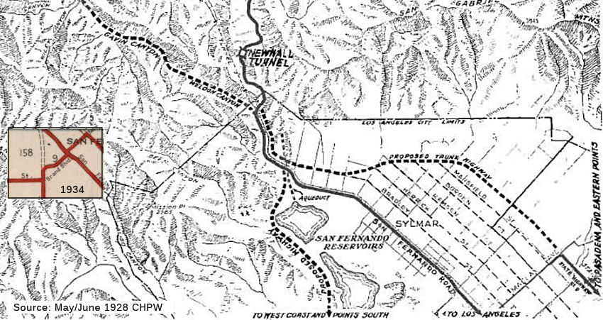 Sign Route 7
corresponds to LRN 158. It appears the original routing for LRN 158 was
intended to be on the other side of the reservoir. A map in the May-June
1928 CHPW shows the planned additional routes approaching Tunnel Station.
One route corresponds to LRN 157, which was defined in 1933 by Chapter 767
as the route from "[LRN 4] near Tunnel Station to [LRN 9] near San
Fernando". This later became part of I-210. The other route corresponds to
what would become LRN 158, defined the route from "[LRN 4] near San
Fernando to [LRN 60] near Mines Field". The 1928 CHPW described it
thusly, "From a point on the south roadway near the Cascade, is is
proposed to build a new highway through the San Fernando Vallev and the
Santa Monica mountains to the West Coast, there to connect with the state
coast highway extending from Oxnard to San Juan Capistrano." This plan
also contemplated the extension of Foothill Blvd: "It will be noted that
the plan contemplates the ultimate extension of the principal streets of
San Fernando westerly to an intersection with the proposed trunk highway.
This will enable travel to filter into San Fernando and points along the
northerly side of the Southern Pacific tracks along more direct lines.".
However, by 1934 and the route adoption, LRN 158 had move to the east side
of the San Fernando Reservoirs (later renamed the Van Norman Dam), with
Balboa Blvd taking the route on the west side of the reservoirs. Based on
USGS map analysis, Balboa Blvd also had some adjustments in this time: a
1941 map shows Balboa going up a route approximating today's Jollette,
Meadowlark, and Sesnon. That routing is also shown in 1952. By the early
1960s, however, Balboa had moved to its current routing closer to Van
Norman Dam. This could be related to movements of the route for home
construction.
Sign Route 7
corresponds to LRN 158. It appears the original routing for LRN 158 was
intended to be on the other side of the reservoir. A map in the May-June
1928 CHPW shows the planned additional routes approaching Tunnel Station.
One route corresponds to LRN 157, which was defined in 1933 by Chapter 767
as the route from "[LRN 4] near Tunnel Station to [LRN 9] near San
Fernando". This later became part of I-210. The other route corresponds to
what would become LRN 158, defined the route from "[LRN 4] near San
Fernando to [LRN 60] near Mines Field". The 1928 CHPW described it
thusly, "From a point on the south roadway near the Cascade, is is
proposed to build a new highway through the San Fernando Vallev and the
Santa Monica mountains to the West Coast, there to connect with the state
coast highway extending from Oxnard to San Juan Capistrano." This plan
also contemplated the extension of Foothill Blvd: "It will be noted that
the plan contemplates the ultimate extension of the principal streets of
San Fernando westerly to an intersection with the proposed trunk highway.
This will enable travel to filter into San Fernando and points along the
northerly side of the Southern Pacific tracks along more direct lines.".
However, by 1934 and the route adoption, LRN 158 had move to the east side
of the San Fernando Reservoirs (later renamed the Van Norman Dam), with
Balboa Blvd taking the route on the west side of the reservoirs. Based on
USGS map analysis, Balboa Blvd also had some adjustments in this time: a
1941 map shows Balboa going up a route approximating today's Jollette,
Meadowlark, and Sesnon. That routing is also shown in 1952. By the early
1960s, however, Balboa had moved to its current routing closer to Van
Norman Dam. This could be related to movements of the route for home
construction.
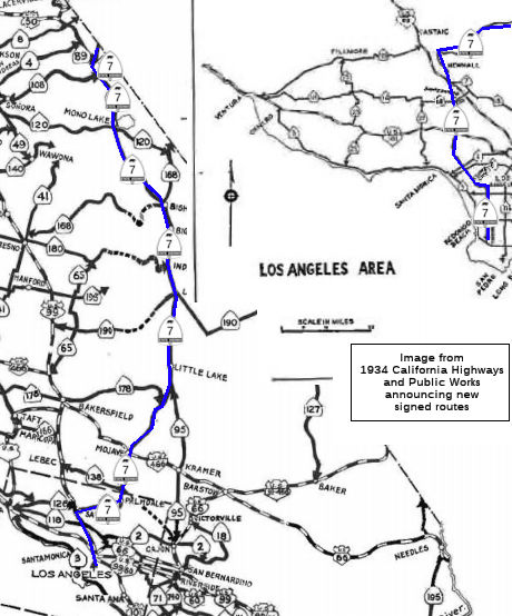
 In 1934, Sign Route 7 was
signed along the route from Jct. Sign Route 3 (US 101A, later Route 1) at
Torrance to the California-Nevada state line north of Coleville, via
Mojave, and from the Nevada-California State Line near Reno Jct. to the
California-Oregon State Line at New Pine Creek via Alturas. This signage
was modified as new US highways were defined that took precedence over the
Sign Route 7 routing: in particular, the designation of US 395 (1935), US 6 (1938), and US 99 (1926). Here is the allocation of the original Sign
Route 7 to segments and legislative route numbers:
In 1934, Sign Route 7 was
signed along the route from Jct. Sign Route 3 (US 101A, later Route 1) at
Torrance to the California-Nevada state line north of Coleville, via
Mojave, and from the Nevada-California State Line near Reno Jct. to the
California-Oregon State Line at New Pine Creek via Alturas. This signage
was modified as new US highways were defined that took precedence over the
Sign Route 7 routing: in particular, the designation of US 395 (1935), US 6 (1938), and US 99 (1926). Here is the allocation of the original Sign
Route 7 to segments and legislative route numbers:
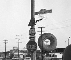 From North of San Fernando to
Westchester, near the present-day Los Angeles International Airport.
This segment originally proceeded down Maclay and Brand in San Fernando
to Sepulveda Blvd. By the mid-1950s, it was running on Sepulveda Blvd
directly from the southern terminus of the "Golden State Freeway" from
approximately San Fernando Blvd (although the map I have doesn't show
Sign Route 7 running N of San Fernando, so it is possible the
routing had been truncated by then). Sign Route 7 then continued S along
Sepulveda to Pico (in the San Fernando Valley, Sepulveda Blvd was at one
time Saugus Avenue; in West Los Angeles, until 1925, Sepulveda Blvd was
originally Military Avenue), where it jogged W to Sawtelle, and then S
to Washington (where it was under construction between Washington and
Centinela). At one time, however, it actually continued along Sepulveda.
It terminated at the interchange of Sepulveda Blvd . and Century Blvd.
US 101A ran along Lincoln, and continued under the LAX Tunnel.
From North of San Fernando to
Westchester, near the present-day Los Angeles International Airport.
This segment originally proceeded down Maclay and Brand in San Fernando
to Sepulveda Blvd. By the mid-1950s, it was running on Sepulveda Blvd
directly from the southern terminus of the "Golden State Freeway" from
approximately San Fernando Blvd (although the map I have doesn't show
Sign Route 7 running N of San Fernando, so it is possible the
routing had been truncated by then). Sign Route 7 then continued S along
Sepulveda to Pico (in the San Fernando Valley, Sepulveda Blvd was at one
time Saugus Avenue; in West Los Angeles, until 1925, Sepulveda Blvd was
originally Military Avenue), where it jogged W to Sawtelle, and then S
to Washington (where it was under construction between Washington and
Centinela). At one time, however, it actually continued along Sepulveda.
It terminated at the interchange of Sepulveda Blvd . and Century Blvd.
US 101A ran along Lincoln, and continued under the LAX Tunnel. By 1938, Sign Route 7 was constructed south of LRN 164/Centinela
Avenue to US 101A/LRN 60 near the grounds of Los Angeles Municipal
Airport. The segment of LRN 158/Sepulveda Boulevard north of LRN 164/Centinela Avenue in Culver City was unconstructed. By 1939,
the segment of Route 7/LRN 158 on Sepulveda Boulevard between Brand
Boulevard and US 99-6/LRN 4 at San Fernando Road was opened. The
segment of Sign Route 7/LRN 158 from Jefferson Boulevard south to
Route 107/LRN 164 at Centinela Avenue was not yet constructed due to
it requiring extensive drainage. By 1942, construction was
authorized for Sign Route 7/LRN 158 on Sepulveda Boulevard from
Slauson Avenue south to Sign Route 107/LRN 164 at Centinela
Avenue.
(Source: Gribblenation Blog (Tom Fearer), "California State Route 107", May 2022)
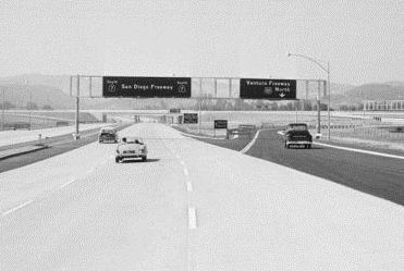 As the San Diego Freeway was constructed, it ran along the San Diego
Freeway. Some portions in the San Fernando Valley were signed as Sign
Route 7 (as indicated in the photo), but portions in West LA were
signed as I-405 (even prior to the great renumbering). These segments
were the original segment of LRN 158 added in 1933. Sepulveda Blvd was
named for the Sepulveda family of early Los Angeles.
As the San Diego Freeway was constructed, it ran along the San Diego
Freeway. Some portions in the San Fernando Valley were signed as Sign
Route 7 (as indicated in the photo), but portions in West LA were
signed as I-405 (even prior to the great renumbering). These segments
were the original segment of LRN 158 added in 1933. Sepulveda Blvd was
named for the Sepulveda family of early Los Angeles.
Scott Parker (SParker) on AAroads
noted: "The initial construction on I-405 actually started shortly
before the Interstate era as a freeway upgrade to then Route 7 (LRN 158) between Culver City and the Santa Monica Mountains; that segment
opened to traffic at the end of 1957 with Sign Route 7 signage; that
was replaced by that summer with I-405 signage." Note that this means
the Route 7 signage on this section existed for perhaps 5-6 months at
best.
(Source: Scott Parker (Sparker) on AAroads, "Re: I-405 widening in Orange County has started", 1/24/2019)
Interesting historical note: There was once a reservoir in Sepulveda Canyon operated by the Santa Monica Water Company. It failed in 1914.
The Sepulveda Tunnel opened on September 27, 1930. Sepulveda Pass was paved and became a state highway route in 1935. In the November 1935 issue of CHPW, there is an interesting article on the Sepulveda Tunnel construction and dedication. Although the tunnel was constructed in 1930, the state highway between Ventura and Sunset was opened and dedicated on October 20, 1935. The article noted that the first steps to a modern Sepulveda came in 1922, as the the Indian footpath was transformed into a highway of commerce. The section opened in 1935, 7.6 mi in length, was from Ventura Blvd to Sunset. It was surfaced with 30-foot asphalt concrete pavement bordered on each side by oil-treated rock shoulders, costing $300K, and financed out of the state gasoline tax. Grading was previously completed in 1930. The tunnel is 665' long, and bored through the mountains 130' under Mulholland Drive. The 1935 project involved the completion of 2.1 mi of new road, and the improvement of 3.3 mi of existing road.
Tom Fearer describes it thusly: The original Sign Route 7 was announced
as a highway originating at Sign Route 3/LRN 60 (future US 101A, later
Route 1) in Torrance northward to the Nevada State Line, which connected
through the Reno Area to a second segment to the Oregon State Line.
Sign Route 7 was originally defined followed the entirety of LRN 164 from
Sign Route 3/LRN 60 north to LRN 158. Sign Route 7 continued north
via LRN 158 to US 99/LRN 4 near San Fernando where it briefly multiplexed
it to LRN 23. Sign Route 7 followed LRN 23 along the eastern flank
of the Sierra Nevada Mountains to Topaz. From Topaz, Sign Route 7
followed LRN 95 to the Nevada State Line where a gap in the highway
existed. Sign Route 7 emerged at the California/Nevada State Line
north of Reno where it followed LRN 29, LRN 28 and LRN 73 towards the
Oregon State Line.
(Source: Gribblenation Blog (Tom Fearer), "California State Route 7", 8/9/2023)
US 395 was approved to be extended into California during 1934 by the American Association of State Highway Officials (AASHO). US 395 would replace Sign Route 7 from near Bradys north to the Oregon State Line. Given the timing of the creation of sign routes (summer 1934) and the extension of US 395, it is unclear if Sign Route 7 was signed in the field along the routing.
 In 1937, US 6 was extended into
California, and would replace Sign Route 7 from US 395 near Bradys to US 99 near San Fernando. This left Sign Route 7 as running from LRN 3 near
Palos Verdes to LRN 23 near Tunnel Station.
In 1937, US 6 was extended into
California, and would replace Sign Route 7 from US 395 near Bradys to US 99 near San Fernando. This left Sign Route 7 as running from LRN 3 near
Palos Verdes to LRN 23 near Tunnel Station.
In 1938, another truncation of Sign Route 7 occurred, when Sign Route 7 was realigned to follow LRN 158/Sepulveda Boulevard south to a terminus at US 101A/LRN 158. The former routing along LRN 164 and Centinela Avenue became Sign Route 107. This changed Sign Route 7 to LRN 60 (US 101A) in Westchester to LRN 23 (US 6) near Tunnel Station.
In 1964, what remained of Sign Route 7 was replaced with I-405, although signage for I-405 began in the late 1950s as the freeway segments were constructed.
1964-1982 Route 7 - Long Beach Freeway
Note that the 1964-1982 Route 7 had been signed as Sign Route 15 [LRN 167], but in 1964 the Route 15 designation was reassigned to I-15. For the history of this route, see the page for I-710 or the entry for LRN 167.
Post-1990 Route 7 at the International Border
Post-1990 Route 7 was not in the state highway system before 1990; in fact, it is new highway.
 Status
A controlled access highway routing has been adopted from Route 98 (~ 007 IMP 1.164) to I-8 (~ 007 IMP 6.695), per the August 2000 CTC Agenda. It was under construction as of October 2002, according to Don Hagstrom. It was open as of March 2012, giving trucks a full expressway route to the interstate, and allowing then to avoid the narrow 2-lane Route 98. A future extension of Route 7 north may be constructed as a routing of a new Route 115 expressway as well, although this is far off.
In September 2009, the CTC relinquished right of way in the county of Imperial along Route 7 from Heber Road to Hunt Road (11-Imp-7-PM 3.7/6.3), consisting of relocated or reconstructed county roads, and frontage roads. This is likely roadway bypassed or modified by the expressway construction.
In September 2019, it was reported that there is an effort underway to
remove trucks from Orchard Road (County Sign Route S32) N of I-8. As part of this effort,
Caltrans proposes to install signage along Route 7 advising drivers of
large trucks going north to avoid Orchard Road and use alternate routes.
Route 7 becomes Orchard at Interstate 8 south of Holtville. As part of a
mid-range proposal, Caltrans is looking to develop a package of guidance
signs to provide directional information for trucks as a part of its
Traffic Investigative Report. The city of Holtville will eventually need
to cooperate with the removal of truck-route designations at Orchard and
Fourth Street, the north terminus of Orchard. Caltrans is looking at a
number of guidance signs, the first at the Commercial Vehicle Enforcement
Facility at the East Port of Entry. There would be another sign on Route 7, midway up, for further notification to truck drivers, and, just south
of I-8 on Route 7, a different sign that indicates the truck route ends in
a half mile. Wording on the signs would read, “Trucks to SR 115 use
I-8 West to SR 111 North.” This would direct trucks northbound from
Mexico to Los Angeles. Also, signs would guide trucks southbound. The
southbound sign would be at the intersection of Route 78 and Route 111 in
Brawley. The sign would read, “Trucks to Route 7 Use Route 111 South
to I-8 East.” A third sign near Holtville for trucks southbound on
Route 115 would read, “Trucks to Route 7 Use Route 115 South to I-8
West.”
(Source: Holtville Tribune, 9/12/2019)
Note: Apparently, a 2007 episode of the TV program "24" featured a Route 7 that ran from the central part of Los Angeles (Florence and something) to Newhall. Although Pre-1964 Route 7 ran to Newhall, it was only from the top of the San Fernando Valley (Sepulveda Blvd), not from Central Los Angeles.
 National Trails
  The portions of 1934 Route 7 that correspond to US 6
and present day Route 14 were part of the Midland Trail.
The portions of 1934 Route 7 that correspond to US 6
and present day Route 14 were part of the Midland Trail.
 Freeway
[SHC 253.1] Entire route.
 Interstate Submissions
In November 1957, the California Department of Highways proposed the designation I-7 for what is now I-505. This was part of an approach to number current I-5 as I-11, and use the single odd digits for what are now loop routes in the San Francisco Bay and Los Angeles areas.
 Statistics
Overall statistics for Route 7:
 Other WWW Links
1964-1982 Route 7 - Long Beach Freeway
Post-1990 Route 7 at the International Border
 Pre-1964 Legislative Route
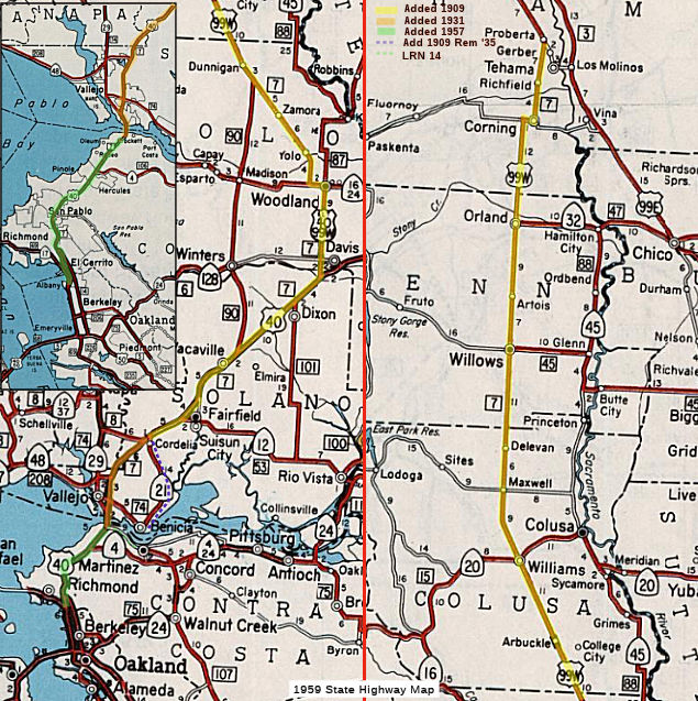 The route that would become LRN 7 was defined in the 1909
first bond act, running from Tehama Junction to Benicia.
The route that would become LRN 7 was defined in the 1909
first bond act, running from Tehama Junction to Benicia.
 The original routing appears to have run from Benicia north-ish to Cordelia along what
became Sign Route 21 to American Canyon, where it ran along American
Canyon Road to Fairfield. From Fairfield it continued up to Davis. Near
Davis, it split off and continued N along what is Route 113. It then
continued along what was US 99W to Tehama Junction, which was just S of
Red Bluff.
The original routing appears to have run from Benicia north-ish to Cordelia along what
became Sign Route 21 to American Canyon, where it ran along American
Canyon Road to Fairfield. From Fairfield it continued up to Davis. Near
Davis, it split off and continued N along what is Route 113. It then
continued along what was US 99W to Tehama Junction, which was just S of
Red Bluff.
In 1931, it was extended by the addition of the secondary routing from [LRN 14] near Crockett to American Canyon Route near Vallejo. The rationale was that the route would provide a connection from the proposed American Canyon Route to [LRN 14] near Crockett. This also provided the connection from Cordelia to the future Carquinez Bridge. This spur provided a complete through road for traffic from the inland valleys to the bay area. Until the new spur was completed, it appears the routing used the newly defined LRN 74.
By 1935, the route was codified as:
The "American Canyon Route" was either LRN 74 or LRN 104. It was then quickly amended by Chapter 274. Chapter 274 seemed to make a number of changes related to the Carquinez Bridge and the Benicia Ferry, one of which was to simplify the definition of LRN 7 to the simpler:
[LRN 14] near Crockett to Red Bluff
Chapter 274 also changed the definition of LRN 74. LRN 74 had been defined first in 1935 as "Vallejo to [LRN 8]". LRN 8 was what became Route 29 in American Canyon, with LRN 8 running from Cordelia to Ignacio. LRN 74 ran from LRN 8 down to Vallejo, along what is now Route 29. Chapter 274 also amended LRN 8 to be: "A point on [LRN 8] near the Napa Y to Cordelia via Vallejo and Benecia". This made LRN 74 "U" shaped, running from American Canyon down to Vallejo, across to Benicia, and then back up towards Cordelia where it met LRN 8 again.
So it seems that Chapter 274 did two major things with respect to LRN 7. First, it closed the gap between Vallejo and Red Bluff. Second, it transferred what had been the original LRN 7 between Benicia and Cordelia to LRN 74, and created a new state route between Benicia and Vallejo. These are what became I-780 and I-680. It also made the second segment essentially part of the mainline. The second segment was not removed until 1939.
By 1935, this was all considered a primary route.
In 1957, Chapter 36 extended the route to Albany, simplifying the definition to “[LRN 69] in Albany to [LRN 3] near Red Bluff”. LRN 69 was signed as Route 17, and is approximately I-580 today. LRN 7 was signed as US 40, and is approximately I-80 today (thus, LRN 7 began near what is now the I-80/I-580 interchange). It continued NNE signed as US 40 (approximately today's I-80) until just SSW of Davis.
LRN 7 continued N cosigned as US99W/Alt US 40 until Woodland. This is present-day Route 113.
LRN 7 then jogged W briefly signed as US99W/Route 16, and then continued N signed as US99W (later the approximate routing of I-5) until the junction with US99E (LRN 3) near Red Bluff.

 The third iteration of the Lincoln Highway was routed out of Sacramento to the West along LRN 6 and LRN 7. It diverted to use
Route 12 (LRN 8) and Route 29 (LRN 74) to return to LRN 7 near Vallejo,
where it met LRN 14 to LRN 5, where it then crossed into San Francisco
(originally via the Ferry, and later the Oakland Bay Bridge on LRN 68).
The route originally terminated in Lincoln Park, six miles west of the
ferry landing at the foot of Market Street. The Lincoln Highway ended
opposite the Palace of the Legion of Honor at a small monument marking the
spot. The last few miles (of the highway) were California Street.
The third iteration of the Lincoln Highway was routed out of Sacramento to the West along LRN 6 and LRN 7. It diverted to use
Route 12 (LRN 8) and Route 29 (LRN 74) to return to LRN 7 near Vallejo,
where it met LRN 14 to LRN 5, where it then crossed into San Francisco
(originally via the Ferry, and later the Oakland Bay Bridge on LRN 68).
The route originally terminated in Lincoln Park, six miles west of the
ferry landing at the foot of Market Street. The Lincoln Highway ended
opposite the Palace of the Legion of Honor at a small monument marking the
spot. The last few miles (of the highway) were California Street.
 The portion of this route between Oakland and Sacramento (LRN 6, LRN 7 and LRN 14), as well as the former US 99E portion to Red
Bluff (LRN 3), was part of the National Park to Park Highway.
The portion of this route between Oakland and Sacramento (LRN 6, LRN 7 and LRN 14), as well as the former US 99E portion to Red
Bluff (LRN 3), was part of the National Park to Park Highway.
© 1996-2024 Daniel P. Faigin.
Maintained by: Daniel P. Faigin
<webmaster@cahighways.org>.
 Route 6
 Route 8