
 California Highways:
Click here for a key to the symbols used. An explanation of acronyms may be found at the bottom of the page.
 Routing
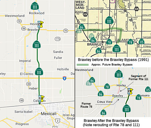 From the international border south of Calexico to Route 78 near Brawley,
passing east of Heber.
From the international border south of Calexico to Route 78 near Brawley,
passing east of Heber.
 Post 1964 Signage History
In 1963, this segment was defined as "(a) Calexico to Route 78 near Brawley passing east of Heber. "
In 1972, Chapter 1216 extended (a) south to change the origin of this segment to "The international boundary south of Calexico".
A discussion of the Highways to Boulevards program during the March 2022
CTC meeting identified the following segment(s) as potential Highways to
Boulevards conversion projects: Route 111 from 2nd Street Calexico (~ IMP
R0.208) to Route 98 (~ IMP 1.154).
(Source: March 2022 CTC Agenda, Agenda Item 4.3)
 Pre 1964 Signage History
Between Calexico and Route 86 E of Haber, this was an extension of LRN 26, defined in 1931. It was originally signed as part of US 99. In March 2021, the Historic Highway 99 Association of California posted signs indicating the route is Historic Route 99.
Between Route 86 E of Haber and Route 78 near Brawley, this was LRN 201, defined in 1933. It is not part of the original 1934 signing of Route 111.
At some point between 1935-1938, Route 111 was extended south of Brawley
over LRN 201 to US 99 near Heber. Route 111 terminating at US 99 in Heber
can be first be seen on the 1938 Division of Highways Map.
(Source: Tom Fearer on AARoads, 11/29/2019)
 Status
In October 2012, the CTC amended the 2012 STIP to delete the Calexico Border Gateway and 1st Street Promenade project (PPNO 0508) on Route 111 in Imperial County. This project was originally programmed in the 2010 STIP - Transportation Enhancement Program for $2,301,000 in Interregional Improvement Program (IIP) funds. The project consists of pedestrian and bicycle improvements in the vicinity of the pedestrian border crossing at the United States/Mexico Border Inspection Station. However, a conflict between this project and a General Services Administration (GSA) contract has resulted in the need to delete this project from the STIP. Following the programming of this project, the GSA condemned the Department’s right of way within the limits of this project in order to construct a new port of entry. This prevented the Department from moving forward with the pedestrian and bicycle improvements project.
In October 2020, the CTC authorized relinquishment of right of way,
consisting of collateral facilities, in the City of Calexico along Route 111, south of Second Street (11-Imp-111-PM 0.1/0.2). The City, by
Resolution No. 2020-43 dated July 15, 2020, agreed to waive the 90-day
notice requirement and accept title upon relinquishment by the
State.
(Source: October 2020 CTC Agenda, Agenda Item 2.3c)
Brawley Bypass
There are also plans to build a 4-lane expressway from between Worthington Road and Keystone Road near Brawley and Imperial (March 2001 CTC Agenda). In June 2002, there was more on this: An agenda item for Route 111 near Brawley from Keystone Road to Route 78 to construct a four-lane expressway.
According to Don Hagstrom in October 2002, Route 111 is undergoing a conversion to 4-lane expressway on parallel alignment between I-8 north of Calexico and the city of Brawley. The first segment from Ross Road (just north of I-8, near IMP PM 8.0) to Worthington (County Sign Route S28, IMP PM 12.9) opened on 23 September 2002. Segment 2 of 3 from Ross Road to Keystone Road (San Diego County Sign Route S27) is under construction now and is scheduled for completion in Fall 2003; Segment 3 from Keystone Road to the current Route 78 (Mead Road) in Brawley will go under construction soon and is scheduled for completion in Fall 2004. This would tie Route 111 into the planned Brawley Bypass (Route 78/Route 86) that would also be constructed as an expressway and would tie into the current Route 86 expressway. This Bypass will also be done by 2006-7. As part of this, the former routing will be relinquished and turned into a frontage road. According to Gary Rotto of Caltrans in September 2005, Route 111 in Imperial County is completed and opened to traffic. In November 2007, bids went out for construction of a 4-lane divided expressway and interchange on "old" Route 111 near Brawley from 0.5 Km South of Shank Road to the New River Bridge.
The SAFETEA-LU act, enacted in August 2005 as the reauthorization of TEA-21, provided the following expenditures on or near this route:
In March 2012, it was reported that not only is the Brawley Bypass under construction (the signs project completion later in 2012), but the eastern part of it has been opened and Route 111 has been moved onto it. That change appears to be recent, as there still is Route 111 signage in downtown Brawley on the old multiplex with Route 78, though the bypassed part of Route 111 north of Route 78 has already been renamed "Old Highway 111". The open part of the bypass is a four-lane expressway with one interchange (tie-in to Route 111/Old Highway 111 north of Brawley) and two at-grade crossings (Best Road, and Route 78).
In May 2012, the CTC amended the the Trade Corridor Improvement Fund (TCIF) baseline agreement for Project No. 77 – Brawley Bypass (Route 78/Route 111 Expressway) – Stage 3 Project (PPNO 0021G) in Imperial County. The amendment revised the project schedule and split off a follow-up landscape mitigation project (PPNO 0021Y). The approved baseline schedule was been revised to update the end of construction and closeout phases. The original construction schedule was developed assuming minimal structural construction on the project. However, during the design phase, a bridge was added to allow for canal maintenance, triggering an extended construction period.
In February 2010, the CTC approved relinquishment of right of way in the county of Imperial along Route 111 between Ross Road and Robinson Road (~ IMP R8.268 to IMP R13.376, along "Old Highway 111"), consisting of superseded highway right of way and collateral facilities.
In September 2010, the CTC approved relinquishment of right of way in the county of Imperial along Route 111 between Robinson Road and 0.5 miles north of Keystone Road (~ IMP R13.356 to IMP R17.87, along "Old Highway 111"), consisting of superseded highway right of way and collateral facilities.
In March 2011, the CTC authorized relinquishment of right of way in the county of Imperial along Route 111 from 0.5 mile south of Carey Road to 0.2 mile north of Mead Road (~ IMP R17.824 to IMP R20.6, along "Old Highway 111"), consisting of superseded highway right of way and collateral facilities.
In December 2011, the CTC authorized relinquishment of right of way in the city of Brawley along Route78 at Best Road and along Route 111 from the south Brawley city limits to Route 78 (IMP R20.667 to Route 78, along "Old Highway 111"), consisting of superseded highway right of way and collateral facilities. The County of Imperial, by controlled access highway agreement dated May 6, 2003, agreed to accept title upon relinquishment by the State to roads which on that date were within an unincorporated area of the county and have since been annexed by the City of Brawley. The City, by controlled access highway agreement dated May 20, 2003, agreed to accept title upon relinquishment by the State.
In August 2011, the CTC approved relinquishment of right of way in the county of Imperial on Route 111 from the northerly city limits of Brawley to the realigned Route 78, consisting of superseded highway right of way (the bypassed segment of Route 111, along N 8th St.).
 Naming
The portion of Route 111 from E. Jasper Road near the City of Calexico to I-8 in the County of Imperial (~ IMP R3.232 to IMP R7.638) is named the Fire Chief F.S. "Pete" Pedroza Memorial Highway. It was named in memory of Froilan S. Pedroza, who was involved in a tragic vehicular accident on October 22, 2003, that took his life. This naming recognizes his service as Fire Chief to the City of Calexico Fire Department. Named by Senate Concurrent Resolution 64, July 8, 2004. Chapter 116.
 The portion of Route 111 between I-8 and Route 78, in Imperial County (~ IMP
R7.638 to IMP R21.993), is officially named the "Imperial Valley
Pioneers Expressway" This segment was named in honor of the pioneers
of Imperial Valley. In 1849, advancements in engineering made it possible
for water to be conveyed from the Colorado River to the interior desert of
Southern California, creating the opportunity for year-round farming. By
1901, courageous pioneers from throughout the world, staking their future
on the region's agricultural promise, began to relocate to the vast desert
area now called the Imperial Valley. These pioneers reflected the cultural
melting pot of the early twentieth century, a patchwork quilt of
peoples–including African American, Chinese, East Indian, Filipino,
French, German, Greek, Irish, Italian, Japanese American, Lebanese,
Mexican, Portuguese, and Swiss–that has contributed to California's
rich diversity today. These pioneers envisioned the potential for
prosperous and thriving communities in the harsh environment of the low
desert, leveling their own land and constructing the first roads and
canals, making way for the development of homes, schools, businesses, and
places of worship. The determination, ingenuity, and hard work of the
Imperial Valley pioneers helped to create a thriving $1 billion annual
agricultural economy, making it one of the most productive farming regions
in California. Imperial Valley pioneers became leading members of the
community, helping to establish civic, religious, charitable, and other
organizations to advance quality of life in the region. The Imperial
Valley Pioneers Association was established in 1928 for the purpose of
uniting pioneer families in the area and educating newcomers about the
history of the early settlers to keep history alive for future
generations. The Pioneers Museum and Cultural Center, located at Pioneers
Park near the City of Imperial, is operated by the Imperial County
Historical Society and is a rich archive of documents, newspapers,
personal letters, period furniture, photographs, clothing, and sundry
equipment used by early settlers, with galleries honoring the different
ethnic communities and their history of settlement in the Imperial Valley.
It is valuable and important to commemorate the remarkable modern history
of the irrigated desert and of the people who settled it, to learn from
the inspiring American story of diverse people uniting around the common
dream of a better future, and to honor the vision and daring of those who
opened the rugged desert frontier and built a community enjoyed by
succeeding generations. Named by Assembly Concurrant Resolution (ACR) 160,
9/10/2010, Resolution Chapter 147.
The portion of Route 111 between I-8 and Route 78, in Imperial County (~ IMP
R7.638 to IMP R21.993), is officially named the "Imperial Valley
Pioneers Expressway" This segment was named in honor of the pioneers
of Imperial Valley. In 1849, advancements in engineering made it possible
for water to be conveyed from the Colorado River to the interior desert of
Southern California, creating the opportunity for year-round farming. By
1901, courageous pioneers from throughout the world, staking their future
on the region's agricultural promise, began to relocate to the vast desert
area now called the Imperial Valley. These pioneers reflected the cultural
melting pot of the early twentieth century, a patchwork quilt of
peoples–including African American, Chinese, East Indian, Filipino,
French, German, Greek, Irish, Italian, Japanese American, Lebanese,
Mexican, Portuguese, and Swiss–that has contributed to California's
rich diversity today. These pioneers envisioned the potential for
prosperous and thriving communities in the harsh environment of the low
desert, leveling their own land and constructing the first roads and
canals, making way for the development of homes, schools, businesses, and
places of worship. The determination, ingenuity, and hard work of the
Imperial Valley pioneers helped to create a thriving $1 billion annual
agricultural economy, making it one of the most productive farming regions
in California. Imperial Valley pioneers became leading members of the
community, helping to establish civic, religious, charitable, and other
organizations to advance quality of life in the region. The Imperial
Valley Pioneers Association was established in 1928 for the purpose of
uniting pioneer families in the area and educating newcomers about the
history of the early settlers to keep history alive for future
generations. The Pioneers Museum and Cultural Center, located at Pioneers
Park near the City of Imperial, is operated by the Imperial County
Historical Society and is a rich archive of documents, newspapers,
personal letters, period furniture, photographs, clothing, and sundry
equipment used by early settlers, with galleries honoring the different
ethnic communities and their history of settlement in the Imperial Valley.
It is valuable and important to commemorate the remarkable modern history
of the irrigated desert and of the people who settled it, to learn from
the inspiring American story of diverse people uniting around the common
dream of a better future, and to honor the vision and daring of those who
opened the rugged desert frontier and built a community enjoyed by
succeeding generations. Named by Assembly Concurrant Resolution (ACR) 160,
9/10/2010, Resolution Chapter 147.
(Image source: AARoads)
 Historical Route
The portion of this route from the international border S of Calexico to Route 86 (~ IMP 0.000 to IMP R21.993) is designated as part of "Historic US Highway 99" by Assembly Concurrent Resolution 19, Chapter 73, in 1993.
In March 2021, the Historic Highway 99 Association of
California posted historic route signs in Calexico. See their page for pictures. Two signs were posted: 1st St and Heffernan Ave, and 2nd St and Imperial Ave.
(Source: SoCalRocks and Roads, 3/24/2021)
 Named Structures
This route also has the following Safety Roadside Rest Areas:
 Freeway
[SHC 253.6] Entire portion. Added to the Freeway and Expressway system in 1959.
 Blue Star Memorial Highway
The portion of this route that is former US 99 was designated as a "North-South Blue Star Memorial Highway" by Senate Concurrent Resolution 33, Ch. 82 in 1947.
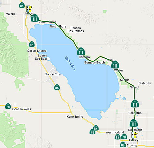 From Route 78 near Brawley to Route 86 via the north
shore of the Salton Sea.
From Route 78 near Brawley to Route 86 via the north
shore of the Salton Sea.
Post 1964 Signage HistoryAs defined in 1963, this segment was "(b) Route 78 near Brawley to Route 86 near Indio via the north shore of Salton Sea."
In 1972, Chapter 1216 extended (b) north, changing the terminus to "Route 86 near Mecca via the north shore of the Salton Sea."
In 1981, Chapter 292 removed the reference to "near Mecca"
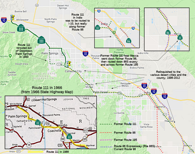
Near Mecca, Route 111 previously ran along Grapefruit Blvd to meet Route 86 at Harrison Street, where old Route 86 continued at Indio Blvd into Indio (Route 111 split off at Dr. Carreon Blvd). After completion of the Route 86 expressway, the routing changed: Route 111 exited Grapefruit near Mecca, continued SW along Lincoln, and then W along 66th Avenueto meet the Route 86 expressway. Route 86 then continued as expressway to I-10. Those following the expressway would need to exit at Dillon or Golf Center to cut back to former Route 111.
Pre 1964 Signage HistoryIn 1934, Route 111 was signed along the route from Jct. US 99 at Brawley to Jct. US 60 at Whitewater, via Mecca, Indio, and Palm Springs. This is LRN 187, defined in 1933.
StatusNiland Mud Spring (~ IMP 45.32)
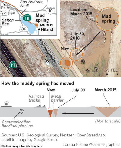 In November 2018, there were reports regarding a concern about an aspect of
the San Andreas Fault other than an earthquake. The San Andreas fault
begins at the Salton Sea. At this point, a muddy spring mysteriously has
begun to move at a faster pace through dry earth — first 60 feet
over a few months, and then 60 feet in a single day, according to Imperial
County officials. The movement is not seismic activity; rather, it is
occurring partly as a result of historic earthquake activity that caused
cracks, allowing gases produced deep underground to reach the
earth’s surface. In the path of the moving spring are Union Pacific
freight railroad tracks that connect the Inland Empire to Yuma, Ariz.; a
petroleum pipeline owned by Kinder Morgan, one of North America’s
largest energy companies; a stretch of fiber optic telecommunications
lines owned by Verizon; and a portion of Route 111, a major roadway
connecting Interstate 10 in the Coachella Valley to the California-Mexico
border (~ IMP 45.32). Imperial County declared an emergency in Summer
2018, enabling officials to expedite efforts to prevent damage and perhaps
even to stop the movement of the spring from getting closer to the
railroad tracks. Officials have been trying to drain water from the moving
spring. Union Pacific built a 100-foot long wall of large boulders and
steel more than 75 feet deep in the earth in an effort to protect the
railroad. But in October 2018, the muddy spring sneaked underneath the
wall, moving it ever closer to railroad tracks. Overall, the pit has moved
more than 240 feet from where it was documented as being in 2008. Based on
publicly available satellite images, the spring hadn’t appeared to
move much until roughly 2015, but movement became particularly noticeable
earlier in 2018. Union Pacific has been forced to build temporary tracks
to avoid running trains over land impacted by the spring. Trains are now
moving more slowly through the area, according to the company. The
railroad may need to consider more permanent solutions, including building
a bridge to bypass potentially unstable land, a company spokesman said.
Caltrans is also prepared to shut down a portion of Route 111 if the mud
spring approaches the roadway, and has already planned a set of detours.
In November 2018, there were reports regarding a concern about an aspect of
the San Andreas Fault other than an earthquake. The San Andreas fault
begins at the Salton Sea. At this point, a muddy spring mysteriously has
begun to move at a faster pace through dry earth — first 60 feet
over a few months, and then 60 feet in a single day, according to Imperial
County officials. The movement is not seismic activity; rather, it is
occurring partly as a result of historic earthquake activity that caused
cracks, allowing gases produced deep underground to reach the
earth’s surface. In the path of the moving spring are Union Pacific
freight railroad tracks that connect the Inland Empire to Yuma, Ariz.; a
petroleum pipeline owned by Kinder Morgan, one of North America’s
largest energy companies; a stretch of fiber optic telecommunications
lines owned by Verizon; and a portion of Route 111, a major roadway
connecting Interstate 10 in the Coachella Valley to the California-Mexico
border (~ IMP 45.32). Imperial County declared an emergency in Summer
2018, enabling officials to expedite efforts to prevent damage and perhaps
even to stop the movement of the spring from getting closer to the
railroad tracks. Officials have been trying to drain water from the moving
spring. Union Pacific built a 100-foot long wall of large boulders and
steel more than 75 feet deep in the earth in an effort to protect the
railroad. But in October 2018, the muddy spring sneaked underneath the
wall, moving it ever closer to railroad tracks. Overall, the pit has moved
more than 240 feet from where it was documented as being in 2008. Based on
publicly available satellite images, the spring hadn’t appeared to
move much until roughly 2015, but movement became particularly noticeable
earlier in 2018. Union Pacific has been forced to build temporary tracks
to avoid running trains over land impacted by the spring. Trains are now
moving more slowly through the area, according to the company. The
railroad may need to consider more permanent solutions, including building
a bridge to bypass potentially unstable land, a company spokesman said.
Caltrans is also prepared to shut down a portion of Route 111 if the mud
spring approaches the roadway, and has already planned a set of detours.
(Source: LA Times, 11/1/2018)
In October 2019, it was reported that construction
began in August 2019 to build a temporary road to provide access to Route 111 at Davis and Gillespie roads about five miles northwest of Niland in
Imperial County. A natural-occurring geyser, in existence since 1953, is
moving toward Route 111 and is likely to reach the highway. The geyser/mud
pot is releasing water, carbon dioxide and hydrogen sulfide gases in low
concentrations and does not pose a health hazard. In the past 11 years,
the geyser has moved slowly; however, the rate of movement has increased,
and the geyser has already encroached the railroad right of way impacting
Union Pacific Railroad tracks. Caltrans plans to rebuild Route 111 as the
geyser moves west and beyond the temporary road. The Niland Geyser
Mitigation Project was constructed in three phases:
(Source: Caltrans Niland Geyser Project Page)
In March 2020, it was reported that Caltrans has been
forced to to build a 5-mi. temporary road adjacent to Route 111 and
install new underground infrastructure for the two-lane highway and the
Union Pacific Railroad to abandon tracks and build new ones in the
Imperial Valley, east of San Diego. Phase 1 of the project had crews from
S&B Engineering Inc. build a temporary road (two lanes) and install
underground infrastructure under Route 111 to deal with the water and
gases when the mud pot passes under the highway. Phase 2 is based on two
elements — build the tie-ins for the temporary road when the mud pot
reaches the road and when it does pass, dismantle the temporary road. The
project was fast-tracked: The contractor was given a two-week shutdown of
the highway and had to work 24 hours a day with two, 12-hour shifts. The
process involved grinding out the hole that they were replacing with dirt
in 24 hours, and then immediately place geogrid fabric, and all the
drainage with different types of aggregate and bring it up to grade. The
excavation went down 12 ft. where slotted drain pipe was installed. The
pipe was fragile and it had to be buried in rock. The contractor couldn't
run equipment on top of it until they got it up to grade to avoid crushing
anything. It was a tight work zone, especially with all the aggregate to
bring in and stockpile adjacent to the Caltrans right-of-way. Once the
subgrade was placed for the existing road, the permeable concrete was
poured and covered by 6 in. of asphalt. All the material excavated from
the existing highway was used to create the subgrade for the temporary
road, which was also covered by 6 in. of asphalt and has a small shoulder
on either side. Work on the project began on Aug. 2019 when construction
crews placed one-way traffic control along a 2,000-ft. segment of SR-111
at Davis and Gillespie roads, about 5 mi. northwest of Niland in Imperial
County. All work was completed by early 2020. The start of second stage of
the project is dependent on how quickly the mud pot moves. As soon as it
reaches the sheet pile wall, perpendicular for 520 ft. west from a nearby
bridge, the tie-ins will be constructed and traffic switched to the
temporary road. The mud pot, one of several thousand in the Imperial
Valley region, has been in existence for about 70 years and has moved
about 100 ft. per year. In 2016 there was a swarm of seismic events and it
began to move faster. There is a deep vent, over one-half mi., that is
venting gases and water through a perched groundwater table. Some believe
it is moving along a fault line. A seismic event could accelerate the
movement or shut it off. Experts are unable to predict the speed or
movement of the mud pot.
(Source: Construction Equipment Guide, 3/9/2020)
In March 2021, it was reported that the Niland Geyser
was still on the move. It's been around since 1953. But, it didn't start
moving until 2016 following some seismic activity in the area, moving
about 10 feet per month on average. The challenge is determining where it
will go next. Caltrans officials considered several options, including a
detour, which wasn't ideal because it would have taken drivers 80 miles
out of the way, and Route 111 is crucial for the agriculture business
there. Instead, a temporary road was built parallel to Route 111, wrapping
drivers around the geyser. As of March 2021, it was 50 feet from the
existing roadway, but s hundreds of feet from the new detour alignment.
Sheet pile walls were also constructed, as well as a sub-surface drainage
system to help control the water being emitted, which some scientists
estimate is around 40,000 gallons a day. The geyser was initially moving
southeast, but has now continued south, so Caltrans is now expanding the
temporary roadway. Their plan is to monitor the geyser until it moves far
enough away to be able to repair the original Route 111 and make that a
permanent road yet again for years to come. The cost of this project is
around $19 million.
(Source: CBS 8, 3/18/2021)
In March 2021, the CTC was informed of the following
emergency SHOPP allocation under delegated authority: (1) #15. $7,500,000.
11-Imp-111 45.2. PPNO 11-1368 ProjID 1119000057 EA 43066. Route 111 Near
Calipatria, south of Gillespie Road. A known mud pot in existence
since 1953 has moved sporadically over decades; however, recent seismic
activity has accelerated the movement and the natural geologic phenomenon
is now within one hundred feet of the roadway. The mudpot was
previously traveling in a southwest direction but has recently changed
course towards the northwest and towards the north end of the recently
constructed detour connection with Route 111. This supplemental is
necessary to extend the north end detour further north to prevent closing
this route caused by the altered direction of the mudpot. CON ENG $0;
CONST $7,500,000.
(Source: March 2021 CTC Agenda, Agenda Item
2.5f.(1) #15)
Route 86 Expressway
A new Route 86 expressway has been built almost to its entire Route 195 length. Currently, the expressway runs from I-10 at Coachella to Mecca, and will eventually join Route 86 at Oasis. The expressway ends near Route 111 in Mecca, and Route 111 between Mecca and Coachella has been rerouted to it. Route 111 thus joins Route 10 at Coachella for a short time and separates from it at Indio to head for Palm Desert and Palm Springs. The segment from Mecca to Coachella will be a joint section of 86 and 111 (it may be signed as such now) upon completion of the remainder of the expressway (at which time, Route 195 will be eliminated).
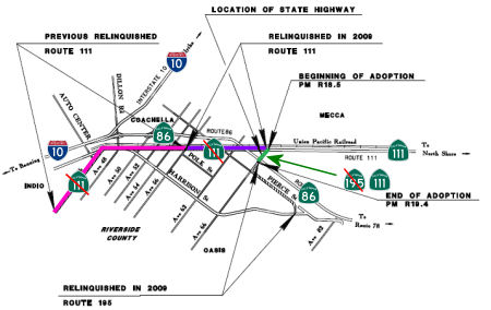 In 2014, a portion of former Route 195 was moved to Route 111. The route adoption noted the history of the route, and specifically
noted how, in March 1988, a supplemental project reported was completed
for a Route 86 expressway between Avenue 82 and Avenue 66 (Route 195) and
for a freeway between Avenue 66 and Dillon Road. This supplemental project
report down scoped the previously approved project on Route 86 from a four
lane freeway to an expressway between Avenue 82 and Avenue 66. In 2001,
the Route 86 Expressway (Route 86S) was completed. The expressway runs
from I-10 at Coachella to join Route 86 at Oasis. The segment from Mecca
to Coachella is a joint section of Route 86 and Route 111. Additionally in
2001, a supplemental project report was completed to address specific
terms of the rehabilitation and relinquishment of existing Route 86, Route 111 and Route 195 in the area. In 2009 the relinquishments for Route 86,
Route 111 and Route 195 were completed. However, a one mile section of
Route 195 between Route 86S (renumbered to Route 86 in December 2012) and
Route 111 (Avenue 66) was not relinquished. Given the definition of Route 195 (which indicates it is no longer a state route), in December 2014 this
segment was adopted as Route 111 Post Mile R18.5 to R19.4.
In 2014, a portion of former Route 195 was moved to Route 111. The route adoption noted the history of the route, and specifically
noted how, in March 1988, a supplemental project reported was completed
for a Route 86 expressway between Avenue 82 and Avenue 66 (Route 195) and
for a freeway between Avenue 66 and Dillon Road. This supplemental project
report down scoped the previously approved project on Route 86 from a four
lane freeway to an expressway between Avenue 82 and Avenue 66. In 2001,
the Route 86 Expressway (Route 86S) was completed. The expressway runs
from I-10 at Coachella to join Route 86 at Oasis. The segment from Mecca
to Coachella is a joint section of Route 86 and Route 111. Additionally in
2001, a supplemental project report was completed to address specific
terms of the rehabilitation and relinquishment of existing Route 86, Route 111 and Route 195 in the area. In 2009 the relinquishments for Route 86,
Route 111 and Route 195 were completed. However, a one mile section of
Route 195 between Route 86S (renumbered to Route 86 in December 2012) and
Route 111 (Avenue 66) was not relinquished. Given the definition of Route 195 (which indicates it is no longer a state route), in December 2014 this
segment was adopted as Route 111 Post Mile R18.5 to R19.4.
With the completion of the Route 86 Expressway, Route 111 exits Grapefruit Blvd at Lincoln, continues to 66th Ave, and continues W along 66th Street to Route 86 (where this segment ends).
In July 2008, the CTC relinquished right of way in the county of Riverside on: Route 86 between Route 86S and Avenue 54 including adjacent right of way along Route 86 for drainage purposes (8-Riv-86-PM 2.68/18.32); Route 111 between Route 195 and Route 86S (8-Riv-111-PM 18.48/20.05), and between Route 86S and the boundary line between Riverside County and the city of Coachella (8-Riv-111-PM 20.13/25.12); and Route 195 between Route 86 and Route 86S (8-Riv-195-PM 0.00/6.45), consisting of superseded highway right of way and collateral facilities.
 Scenic Route
[SHC 263.6] From Bombay Beach in Salton Sea State Park to Route 195 near Mecca.
Freeway[SHC 253.6] Entire portion. Added to the Freeway and Expressway system in 1959.
Naming The portion of Route 111 in the County of Imperial, between PM IMP 33 and PM
IMP 37.6 N of Calipatria is named the “U.S. Army SP4 Dwayne M.
Patterson Memorial Highway”. It was named in memory of Dwayne
Maxifield Patterson, born in November 1941 in Elk City, Oklahoma. Dwayne
attended high school in Oklahoma and at Calipatria High School in
Calipatria, California, where he played baseball. After high school,
Dwayne worked for Imperial Pre-Mix in El Centro, California. While
employed at Imperial Pre-Mix, Dwyane was drafted into the United States
Army in September 1965, where, after basic training, he was transferred to
Ft. Bliss, Texas, and later to Ft. Polk, Louisiana, where he was adjudged
the “Outstanding Trainee” in combat jungle warfare. Dwayne was
then transferred to Ft. Knox, Kentucky, to learn how to drive an Armored
Personnel Carrier (APC), where he was runner-up for the top honors as an
APC driver. Dwayne was transferred to Vietnam on March 26, 1967, where he
was assigned to the “Big Red 1 Division”. Soon after his
arrival, Dwayne was driving an APC when his vehicle hit a land mine.
Dwayne was awarded the Purple Heart for injuries sustained; and after
recovering from those injuries, Dwayne was on a night defensive perimeter
patrol on December 3, 1967, when his unit was ambushed. the attack
continued, and while Dwayne was bravely assisting in evacuating wounded
personnel, he sustained a fatal injury. Named by Senate Resolution SCR 15, Resolution Chapter 83, 07/16/21).
The portion of Route 111 in the County of Imperial, between PM IMP 33 and PM
IMP 37.6 N of Calipatria is named the “U.S. Army SP4 Dwayne M.
Patterson Memorial Highway”. It was named in memory of Dwayne
Maxifield Patterson, born in November 1941 in Elk City, Oklahoma. Dwayne
attended high school in Oklahoma and at Calipatria High School in
Calipatria, California, where he played baseball. After high school,
Dwayne worked for Imperial Pre-Mix in El Centro, California. While
employed at Imperial Pre-Mix, Dwyane was drafted into the United States
Army in September 1965, where, after basic training, he was transferred to
Ft. Bliss, Texas, and later to Ft. Polk, Louisiana, where he was adjudged
the “Outstanding Trainee” in combat jungle warfare. Dwayne was
then transferred to Ft. Knox, Kentucky, to learn how to drive an Armored
Personnel Carrier (APC), where he was runner-up for the top honors as an
APC driver. Dwayne was transferred to Vietnam on March 26, 1967, where he
was assigned to the “Big Red 1 Division”. Soon after his
arrival, Dwayne was driving an APC when his vehicle hit a land mine.
Dwayne was awarded the Purple Heart for injuries sustained; and after
recovering from those injuries, Dwayne was on a night defensive perimeter
patrol on December 3, 1967, when his unit was ambushed. the attack
continued, and while Dwayne was bravely assisting in evacuating wounded
personnel, he sustained a fatal injury. Named by Senate Resolution SCR 15, Resolution Chapter 83, 07/16/21).
(Image source: Holtville Tribune, 6/25/2020)
 The western city limits of Cathedral City to Route 10 near Whitewater.
(b) The relinquished former portions of Route 111 within the unincorporated area of the County of Riverside and the Cities of Cathedral City, Coachella, Indian Wells, Indio, La Quinta, Palm Desert, and Rancho Mirage are not state highways and are not eligible for adoption under Section 81. For the relinquished former portions of Route 111, the County of Riverside and the Cities of Cathedral City, Coachella, Indian Wells, Indio, La Quinta, and Palm Desert, as applicable, shall maintain within their respective jurisdictions signs directing motorists to the continuation of Route 111 and shall ensure the continuity of traffic flow on the relinquished portions of Route 111, including any traffic signal progression.
(c) (1) The commission may relinquish to the City of Palm Springs any portion, or the entirety, of Route 111 within its city limits, upon terms and conditions the commission finds to be in the best interests of the state, if the department and the city enter into an agreement providing for that relinquishment.
(2) A relinquishment under this subdivision shall become effective on the date following the county recorder’s recordation of the relinquishment resolution containing the commission’s approval of the terms and conditions of the relinquishment.
(3) On and after the effective date of the relinquishment, all of the following shall occur:
(A) Any portion of Route 111 relinquished pursuant to this subdivision shall cease to be a state highway.
(B) Any portion of Route 111 relinquished pursuant to this subdivision shall be ineligible for future adoption under Section 81.
(C) For any portion of Route 111 relinquished pursuant to this subdivision, the City of Palm Springs shall maintain signs within its city limits directing motorists to the continuation of Route 111.
Post 1964 Signage HistoryIn 1963, this segment was defined as "(c) Route 10 near Indio to Route 10 near White Water passing near Palm Desert."
In 1976, Chapter 1354 changed "White Water" to "Whitewater"
In the early to mid 1990s, Route 111 was routed off of Palm Canyon Drive (the traditional downtown routing) onto Gene Autry. That move was deemed a prerequisite for the city of Palm Springs to institute traffic calming and other modifications to Palm Canyon Drive.
In 1996, Chapter 1154 deleted the portions in Rancho Mirage and Cathedral City, splitting this into two segments "(c) Route 10 near Indio to the southeast city limit of Rancho Mirage. (d) West city limits of Cathedral City to Route 10 near Whitewater, passing near Palm Desert."
In 2003 (AB 1717, Ch. 525, 9/25/03), the definition was amended to clarify that the portions in Rancho Mirage and Cathedral City cannot become a state highway again. It also made some minor wording changes in the definition "(c) Route 10 near Indio to the southeastern city limits of Rancho Mirage. (d) The western city limits of Cathedral City to Route 10 near Whitewater."
Senate Bill 186, Ch. 594, 10/6/2005 deleted the phrase "passing near Palm Desert", and permitted the CTC to relinquish to the Cities of Indian Wells, Indio, and Palm Desert the respective portions of Route 111 that are located within the city limits of those cities, upon terms and conditions the commission finds to be in the best interests of the state, if the department and the applicable city enter into an agreement providing for that relinquishment. The Cities of Indian Wells, Indio, and Palm Desert, as applicable, are required to maintain within their respective jurisdiction signs directing motorists to the continuation of Route 111.
In October 2006, pursuant to the above, the CTC had a resolution to relinquish right of way of Route 111 in the city of Indian Wells, under terms and conditions determined to be in the best interest of the State as stated in the cooperative agreement to be approved by the city in October 2006. Authorized by Chapter 594, Statutes of 2005, which amended Section 411 of the Streets and Highways Code.
In January 2007, the CTC considered relinquishment of right of way in the city of Indio, under terms and conditions determined to be in the best interest of the State, as stated in the cooperative agreement with the City, which is anticipated to be approved in January 2007. Authorized by Chapter 594, Statutes of 2005, which amended Section 411 of the Streets and Highways Code. It appears that the I-10 exit to Golf Center Pkwy was signed as Route 111 for a while (and was the source of some L mileage).
Senate Bill 224, Chaptered October 14, 2007, Chapter 718, added the City of La Quinta to the list of cities authorized for relinquishment.
In January 2008, the CTC relinquished the right of way in the city of La Quinta, under terms and conditions as stated in the relinquishment cooperative agreement, dated December 6, 2007, determined to be in the best interest of the State. Authorized by Chapter 718, Statutes of 2007, which amended Section 411 of the Streets and Highways Code.
In March 2008, the CTC relinquished right of way in the city of Palm Desert, under terms and conditions as stated in the cooperative agreement, dated December 10, 2007, determined to be in the best interest of the State. Authorized by Chapter 594, Statutes of 2005, which amended Section 411 of the Streets and Highways Code.
In February 2009, the CTC relinquished right of way in the city of Cathedral City along Route 111 east of Golf Club Drive, consisting of highway right of way that is no longer part of the State Highway System.
In 2009, Route 111 was realigned off of Grapefruit Boulevard onto its
original alignment on 66th Avenue west of Mecca to reach the new Route 86
expressway. This segment of 66th Avenue had been more recently part of
Route 195 and was formally added back to Route 111 in 2014 as Post Mile
RIV 18.5-19.4.
(Source: Tom Fearer, "California State Route 111 in Coachella Valley")
In 2010, Chapter 421 (SB 1318, 9/29/10) changed the definition to reflect
all the relinquishments: "(c) From Route 10 near Indio to the
southeastern city limits of Rancho Mirage. (d) western city limits
of Cathedral City to Route 10 near Whitewater"
In 2012, Chapter 769 (AB 2679, 9/29/12) updated the reliquishment text to reflect the relinquishment in the unincorporated areas of the County of Riverside.
In 2018, AB 2272, Chapter 433, Statutes of 2018, 9/17/2018, added the following section:
(c) (1) The commission may relinquish to the City of Palm Springs any portion, or the entirety, of Route 111 within its city limits, upon terms and conditions the commission finds to be in the best interests of the state, if the department and the city enter into an agreement providing for that relinquishment.
(2) A relinquishment under this subdivision shall become effective on the date following the county recorder’s recordation of the relinquishment resolution containing the commission’s approval of the terms and conditions of the relinquishment.
(3) On and after the effective date of the relinquishment, all of the following shall occur:
(A) Any portion of Route 111 relinquished pursuant to this subdivision shall cease to be a state highway.
(B) Any portion of Route 111 relinquished pursuant to this subdivision shall be ineligible for future adoption under Section 81.
(C) For any portion of Route 111 relinquished pursuant to this subdivision, the City of Palm Springs shall maintain signs within its city limits directing motorists to the continuation of Route 111.
Pre 1964 Signage HistoryIn 1934, Route 111 was signed along the route from Jct. US 99 at Brawley to Jct. US 60 at Whitewater, via Mecca, Indio, and Palm Springs. This is LRN 187, defined in 1933. A portion of this route was at one time part of US 99.
In 1950, a new direct path of Route 111 northbound from Mecca to Thermal
was opened via Grapefruit Boulevard. The original alignment of Route 111
used a less direct route from Mecca via; west 66th Avenue, north Pierce
Street and Grapefruit Boulevard. By 1950, Route 111 on Palm Canyon Drive
west of Palm Springs had been partially expanded to an expressway. By
1958, Route 111 on Palm Canyon Drive in downtown Palm Springs had been
expanded to expressway capacity. By 1960 the expressway expansion
continued, with the segment west of Palm Springs on Palm Canyon Drive
almost entirely all the way to US 99/US 60/US 70 being so designated. In
1964, the route in Palm Desert was converted to expressway, and by 1967,
it was expressway between Palm Springs and Palm Desert. By 1970, the
expressway was expanded to Coachella.
(Source: Tom Fearer, "California State Route 111 in Coachella Valley")
In the 1950s, portions were cosigned with Route 74.
StatusIn March 2013, the CTC approved for future consideration of funding a project that is located on Route 111 in the City of Indian Wells in Riverside County. The project will widen Route 111 from four to six lanes for a distance of approximately 4 miles. Other proposed roadway improvements include but are not limited to: installation of landscaped medians, dual left turn lanes, construction of bus turnouts, traffic signal modifications, storm drain catch basin relocations and rubberized asphalt overlay. The project will be constructed in phases. Phase III of the project will widen Route 111 from four to six lanes and construct other roadway improvements from 950 feet east of Cook Street to Hospitality Court, for a distance of approximately 3,000 feet and is programmed in the SLPP program of projects. Phase III of the project is estimated to cost $3,100,000. The project is fully funded through construction with SLPP ($1,550,000) and Local ($1,550,000) funds. Construction is estimated to begin in fiscal year 2012/13.
In December 2021, the CTC authorized the following allocation:
$6,752,000. 08-Riv-111 47.3/55.3. PPNO 08-3007U; ProjID 0817000230; EA
0R302. Route 111 In Palm Springs, from Golf Club Drive to Gateway Drive.
Outcome/Output: Reconstruct and construct curb ramps, add detectable
warning surfaces, reconstruct sidewalks, and add pedestrian crosswalk push
buttons to comply with Americans with Disabilities Act (ADA) standards.
Allocation: CON ENG $2,590,000; CONST $6,647,000.
(Source: December 2021 CTC Agenda, Agenda Item
2.5b.(1) #20)
In February 2019, it was reported that crews assessing damage after the
January and February 2019 rains have found roadways in need of major
repairs. Route 111 from Gateway Drive (RIV 55.258) to I-10 (RIV R63.255)
and Tramway Road leading up to the Palm Springs Aerial Tramway are just
two examples of roads that may be closed indefinitely. Caltrans announced
Friday afternoon that $14 million in emergency contracts have been awarded
for road repairs in Riverside and San Bernardino counties. Route 111
repairs will be funded through a $3.5 million contract.
(Source: Desert Sun, 2/15/2019)
NamingHistorically, a portion of this segment (from Route 74 to Rancho Mirage) has been named the "Pines to Palms Highway".
 The portion of (former) Rout 111 from Washington Street in the City of La Quinta to Jefferson Street in the City of La Quinta in Riverside County is officially named the "Deputy
Bruce Lee Memorial Highway". It was named in memory of Deputy Bruce
Lee of the Riverside County Sheriff's Department, who died while
responding to a domestic disturbance call. His untimely death at 45 years
of age brought immense sorrow to the people of the community and the
state, and to countless individuals whose lives he touched. Deputy Bruce
Lee was recognized throughout the community as a fair man who treated
people with respect and always went out of his way to help others, as the
friendly officer on the beat, and as the officer who enjoyed his job and
liked working for and serving the community. He began his career with the
Riverside County Sheriff's Department on September 2, 1980, and in his
assignment to the Indio Station, he demonstrated the highest standards of
law enforcement. Named by Senate Concurrent Resolution (SCR) 5, Resolution
Chapter 15, on 04/22/2005.
The portion of (former) Rout 111 from Washington Street in the City of La Quinta to Jefferson Street in the City of La Quinta in Riverside County is officially named the "Deputy
Bruce Lee Memorial Highway". It was named in memory of Deputy Bruce
Lee of the Riverside County Sheriff's Department, who died while
responding to a domestic disturbance call. His untimely death at 45 years
of age brought immense sorrow to the people of the community and the
state, and to countless individuals whose lives he touched. Deputy Bruce
Lee was recognized throughout the community as a fair man who treated
people with respect and always went out of his way to help others, as the
friendly officer on the beat, and as the officer who enjoyed his job and
liked working for and serving the community. He began his career with the
Riverside County Sheriff's Department on September 2, 1980, and in his
assignment to the Indio Station, he demonstrated the highest standards of
law enforcement. Named by Senate Concurrent Resolution (SCR) 5, Resolution
Chapter 15, on 04/22/2005.
(Image source: Find a Grave)
 Vega and Police Officer Lesley Zerebny Memorial Highway") The portion of Rout 111 from Overture Drive (post mile 58.478) to West San Rafael Drive (post
mile 54.413) in the County of Riverside is named the "Police Officer
Jose “Gil” Vega and Police Officer Lesley Zerebny Memorial
Highway". It was named in memory of Jose Vega and Lesley Zerebny.
Jose “Gil” Vega began his career in law enforcement as a
reserve police officer for the Indio Police Department in 1982 and became
a reserve police officer for the Palm Springs Police Department later that
year. Officer Vega became a police officer trainee with the Palm Springs
Police Department in 1985, and, after graduating from the police academy,
he was promoted to a police officer later that year. In his 34-year career
in law enforcement, Officer Vega had various assignments. He was a very
successful detective with the Riverside Auto Theft Interdiction Detail and
with the Property Crimes Division of the Palm Springs Police Department.
Officer Vega also served on the Palm Springs Police Department’s
Mounted Enforcement Unit. Officer Vega served as a training officer and,
during his time with the department, trained over 30 police officers, many
of whom were promoted up through the ranksd. Officer Vega was very highly
decorated. He is the only officer to have been twice named the Palm
Springs Police Department’s “Officer of the Year,” first
in 1992 and then again in 2011. He received a medal in 2010 for saving the
life of an infant and received a Medal of Merit in 2013. Officer Vega also
received many complimentary letters regarding his excellent work
performance during his time with the department. Officer Vega was set to
retire from the Palm Springs Police Department on December 28, 2016, and
was to be awarded a Special Recognition Award for his 34 years of
exemplary and dedicated law enforcement service. The other officer
memorialized, Lesley Zerebnym was born and raised in Hemet, California,
and wanted to be a police officer from a very young age. Officer Zerebny
came from a family of law enforcement officers. Her father served as a
California Highway Patrol officer for 30 years and her husband is a deputy
in the Riverside County Sheriff’s Department. Officer Zerebny was
hired as a police officer trainee by the Palm Springs Police Department in
2014 and was promoted to a police officer after graduating from the police
academy. Officer Zerebny had a great attitude toward her career as a
police officer, never hesitating to take on additional tasks and offering
to help out the department and her fellow officers in any way she could.
After giving birth to a daughter in 2016, she returned to work early to
help out. While responding to a domestic disturbance call, Officer Vega
and Officer Zerebny were fatally shot in Palm Springs on October 8, 2016.
Named by ACR 2, 8/30/2017, Res. Chapter 125, Statutes of 2017.
The portion of Rout 111 from Overture Drive (post mile 58.478) to West San Rafael Drive (post
mile 54.413) in the County of Riverside is named the "Police Officer
Jose “Gil” Vega and Police Officer Lesley Zerebny Memorial
Highway". It was named in memory of Jose Vega and Lesley Zerebny.
Jose “Gil” Vega began his career in law enforcement as a
reserve police officer for the Indio Police Department in 1982 and became
a reserve police officer for the Palm Springs Police Department later that
year. Officer Vega became a police officer trainee with the Palm Springs
Police Department in 1985, and, after graduating from the police academy,
he was promoted to a police officer later that year. In his 34-year career
in law enforcement, Officer Vega had various assignments. He was a very
successful detective with the Riverside Auto Theft Interdiction Detail and
with the Property Crimes Division of the Palm Springs Police Department.
Officer Vega also served on the Palm Springs Police Department’s
Mounted Enforcement Unit. Officer Vega served as a training officer and,
during his time with the department, trained over 30 police officers, many
of whom were promoted up through the ranksd. Officer Vega was very highly
decorated. He is the only officer to have been twice named the Palm
Springs Police Department’s “Officer of the Year,” first
in 1992 and then again in 2011. He received a medal in 2010 for saving the
life of an infant and received a Medal of Merit in 2013. Officer Vega also
received many complimentary letters regarding his excellent work
performance during his time with the department. Officer Vega was set to
retire from the Palm Springs Police Department on December 28, 2016, and
was to be awarded a Special Recognition Award for his 34 years of
exemplary and dedicated law enforcement service. The other officer
memorialized, Lesley Zerebnym was born and raised in Hemet, California,
and wanted to be a police officer from a very young age. Officer Zerebny
came from a family of law enforcement officers. Her father served as a
California Highway Patrol officer for 30 years and her husband is a deputy
in the Riverside County Sheriff’s Department. Officer Zerebny was
hired as a police officer trainee by the Palm Springs Police Department in
2014 and was promoted to a police officer after graduating from the police
academy. Officer Zerebny had a great attitude toward her career as a
police officer, never hesitating to take on additional tasks and offering
to help out the department and her fellow officers in any way she could.
After giving birth to a daughter in 2016, she returned to work early to
help out. While responding to a domestic disturbance call, Officer Vega
and Officer Zerebny were fatally shot in Palm Springs on October 8, 2016.
Named by ACR 2, 8/30/2017, Res. Chapter 125, Statutes of 2017.
(Image source: Patch, Officer Down Memorial Page (Vega), Officer Down Memorial page (Zerebny))
 Business Routes
Apparantly, there is at least one sign for Business Route 111 pointing towards the pre-1990 routing in Palm Springs (South Palm Canyon Drive and East Palm Canyon Drive).
Scenic Route[SHC 263.6] Entire portion.
Freeway[SHC 253.6] From San Rafael Dr. in Palm Springs to Route 10. Added to the Freeway and Expressway system in 1959.
 Other WWW Links Blue Star Memorial Highway
The portion of this route that is former US 99 was designated as a "Blue Star Memorial Highway" by Senate Concurrent Resolution 33, Ch. 82 in 1947.
 Interregional Route
[SHC 164.15] Between the Mexico border near Calexico and Route 10 near Whitewater.
 National Trails
 This route is part of the De Anza National Historic Trail.
 Statistics
Overall statistics for Route 111:
 Pre-1964 Legislative Route
In 1933, Chapter 767 defined the route from "[LRN 23] near Rush Creek via June Lake to [LRN 23]" as a state highway. In 1935, this was added to the highway code as LRN 111. The definition remained unchanged until the 1963 renumbering The route ran from US 395 near Rush Creek via June Lake back to US 395, and was present-day Route 158, the June Lake Loop.
© 1996-2020 Daniel P. Faigin.
Maintained by: Daniel P. Faigin
<webmaster@cahighways.org>.
 Route 110
 Route 112