
 California Highways:
Click here for a key to the symbols used. An explanation of acronyms may be found at the bottom of the page.
 Routing
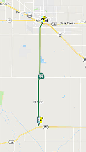 From Route 152 northerly to Route 99 near Merced.
 Post 1964 Signage History
This segment remains as defined in 1963
 Pre 1964 Signage History
This was LRN 123, defined in 1933. It was first signed as Route 59 in 1961; Route 59 was not defined as part of the initial state signage of routes in 1934. Route 59 was first defined in January 1961.
 Status
Merced Pavement Anchor Project (10-Mer-59, PM R0.0/R12.1)
In August 2022, the CTC approved for future
consideration of funding the following project for which a MND has been
completed: Route 59 in Merced County. Repairing and replacing existing
roadway and damaged culverts; bridge rehabilitation work on 3 bridges
(Deadman Creek (PM MER 7.90), Owens Creek (PM MER 11.37), Miles Creek (PM
MER 11.89)); and replace the Mariposa Creek bridge (PM MER 10.4) will a
new elevated bridge on Route 59 in Merced County. (PPNO 3439) The project
is located on Route 59 between postmile R0.0 and R12.1, in Merced County.
The Department proposes to rehabilitate pavement, upgrade guardrail and
lighting, replace sign panels, construct rumble strips, rehabilitate
drainage, replace one bridge, rehabilitate three bridge decks, relocate
utility poles. This project is currently programmed in the 2022 SHOPP,
which includes $22,659,000 is currently through G-13 contingency.
Construction is estimated to begin in 2023-24. The scope, as described for
the preferred alternative, is consistent with the project scope as
programmed by the Commission in the 2022 SHOPP.
(Source: August 2022 CTC Agenda, Agenda Item
2.2c.(1))
In August 2022, the CTC approved the following
pre-construction phase allocation: $2,572,000. 10-Mer-59 R0/12.1. PPNO
10-3439; ProjID 1018000284; EA 0V690. Route 59 Near Merced, from Route 152
to Reilly Road. Rehabilitate pavement, upgrade guardrail and lighting,
replace sign panels, construct rumble strips, rehabilitate drainage,
replace one bridge, and rehabilitate two bridge decks. Allocation: FY23-24
PS&E $1,962,000; R/W Sup $610,000. Future consideration of funding
approved under Resolution E-22-68; August 2022.
(Source: August 2022 CTC Agenda, Agenda Item 2.5b.(2b) #24)
Gerald Ave Roundabout (10-Mer-59 13.6)
 The 2020 SHOPP, approved in May 2020, included the following Collision
Reduction item of interest (carried over from the 2018 SHOPP):
10-Merced-59 PM 13.6 PPNO 3466 Proj ID 1019000059 EA 1K620. Route 59 near
the city of Merced, at the intersection with Gerald Avenue. Intersection
improvements. Programmed in FY23-24, with construction scheduled to start
in December 2024. Total project cost is $10,140K, with $5,908K being
capital (const and right of way) and $4,232K being support (engineering,
environmental, etc.).
The 2020 SHOPP, approved in May 2020, included the following Collision
Reduction item of interest (carried over from the 2018 SHOPP):
10-Merced-59 PM 13.6 PPNO 3466 Proj ID 1019000059 EA 1K620. Route 59 near
the city of Merced, at the intersection with Gerald Avenue. Intersection
improvements. Programmed in FY23-24, with construction scheduled to start
in December 2024. Total project cost is $10,140K, with $5,908K being
capital (const and right of way) and $4,232K being support (engineering,
environmental, etc.).
(Source: 2020 Approved SHOPP a/o May 2020)
In May 2020, the CTC approved the following allocation:
10-Mer-59 13.6. PPNO 3466 ProjID 1019000059 EA 1K620. Route 59 Near the
city of Merced, at the intersection of Gerald Avenue. Construct
roundabout. Allocation: PA&ED $1,036,000.
(Source: May 2020 CTC Agenda, Agenda Item 2.5b.(2)
#28)
In December 2022, the CTC approved for future
consideration of funding the following project for which a ND has been
completed: Route 59 in Merced County (10-Mer-59, PM 13.4/13.8). Safety
intersection improvements from 0.2 mile south (post mile 13.4) to 0.2 mile
north (post mile 13.8) of the intersection of Route 59 and Gerard Avenue,
in Merced County. (PPNO 10-3466) The project is located on Route 59 at
postmile 13.4 and 13.6, in Merced County. The Department proposes to
replace the intersection of Route 59 and Gerald Avenue with a roundabout.
The project is currently programmed in the 2022 SHOPP for a total of
$10,140,000 which includes Right of Way (support and capital) and
Construction (support and capital). Construction is estimated to begin
2024-25. The scope, as described for the preferred alternative, is
consistent with the project scope as programmed by the Commission in the
2022 SHOPP.A copy of the ND has been provided to Commission staff. The
project will result in less than significant impacts to the environment.
As a result, an ND was completed for this project.
(Source: December 2022 CTC Agenda, Agenda Item
2.2c.(1))
In December 2022, the CTC approved the following
pre-construction phase SHOPP allocation: $2,111,000. 10-Mer-59 13.6. PPNO
10-3466; ProjID 1019000059; EA 1K620. Route 59 Near the city of Merced, at
the intersection with Gerald Avenue. Intersection improvements. Concurrent
consideration of funding under Resolution E-22-100; December 2022.
Allocation (Programmed): PS&E $1,616,000 ($1,588,000); R/W Sup
$495,000.
(Source: December 2022 CTC Agenda, Agenda Item
2.5b.(2a) #12)
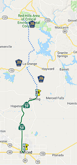 From Route 99 near Merced to Snelling.
Post 1964 Signage HistoryThis segment remains as defined in 1963
Pre 1964 Signage HistoryThis was LRN 123, defined in 1933. It was first signed as Route 59 in 1961; Route 59 was not defined as part of the initial state signage of routes in 1934. Route 59 was first defined in January 1961.
Evidently, there were plans to extend this North of Snelling, but this
never made it into the legislative definition. Part of the reason for this
was Route 65, which was intended to serve as the termination point for
Route 59 near Snelling. This is part of the reason that route never
continued northward along County Sign Route J59 to either Route 132 or Route 108/Route 120 (aside from the cost required to make that road a safe and efficient
thoroughfare to and from Gold Country recreational points).
(Source: Sparker @ AAroads, 7/3/2016)
StatusOlive/Sante Fe Intersection, Merced (MER 16.1)
 In March 2019, it was reported
that Caltrans announced it is breaking ground on several projects to
improve roads in Merced County, including a project that will enhance the
intersection of northbound and southbound Route 59 at Olive Avenue and
Santa Fe Drive in Merced. The estimated $5.7 million project includes
widening of the intersection to install curb ramps. The project also
includes plans for a crosswalk with new signals to improve timing and an
extension of turning lanes to avoid traffic backups, according to
Caltrans. Caltrans said construction for this project is expected to begin
in April and conclude in September.
In March 2019, it was reported
that Caltrans announced it is breaking ground on several projects to
improve roads in Merced County, including a project that will enhance the
intersection of northbound and southbound Route 59 at Olive Avenue and
Santa Fe Drive in Merced. The estimated $5.7 million project includes
widening of the intersection to install curb ramps. The project also
includes plans for a crosswalk with new signals to improve timing and an
extension of turning lanes to avoid traffic backups, according to
Caltrans. Caltrans said construction for this project is expected to begin
in April and conclude in September.
(Source: Merced Sun-Star, March 13, 2019)
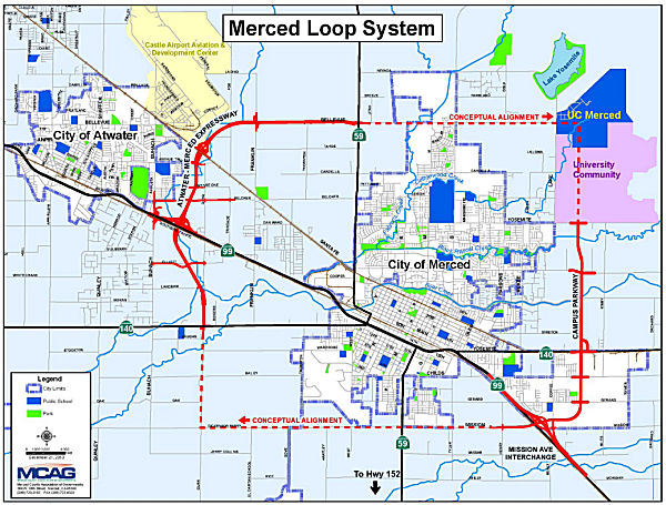
Merced-Atwater Expressway/Campus Parkway (~ 059 MER 18.948 to ~ 140 MER 32.535)
There are plans to widen this to a four lane expressway near Merced. The EIR was completed in September 2002 per CTC Agenda.
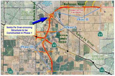 The Merced County Association of Governments (MCAG) is the CEQA lead agency
for the Merced-Atwater Project. The project will widen a seven mile long
north-south corridor to a six-lane freeway (~ 059 MER 18.948 to ~ 140 MER
32.535). The project will connect Route 59 with Route 140. The project
will cross Route 99 and include a new interchange. Specifically, it runs
from 1.2 miles south of Buhach Road to 0.33 mile north of Buhach Road. The
project includes including demolition of Buhach Road interchange &
construction of a new interchange. Details on the project may be found on
the MCAG website.
The Merced County Association of Governments (MCAG) is the CEQA lead agency
for the Merced-Atwater Project. The project will widen a seven mile long
north-south corridor to a six-lane freeway (~ 059 MER 18.948 to ~ 140 MER
32.535). The project will connect Route 59 with Route 140. The project
will cross Route 99 and include a new interchange. Specifically, it runs
from 1.2 miles south of Buhach Road to 0.33 mile north of Buhach Road. The
project includes including demolition of Buhach Road interchange &
construction of a new interchange. Details on the project may be found on
the MCAG website.
The project as proposed will result in significant unavoidable impacts to noise; land use and agriculture; wetlands; and biological resources. Mitigation measures and/or alternatives to the proposed project that would substantially reduce or avoid these significant unavoidable impacts are infeasible. Specifically, the project would increase ambient noise levels in the project vicinity; expose persons to noise levels in excess of standards established in the City of Atwater and Merced County General Plans; and implementation of project plans could result in significant cumulative impacts to land use and agriculture; population and housing; visual resources; noise; hydrology and drainage; biological resources and wetlands; and Greenhouse Gas Emissions.
On March 19, 2009, MCAG adopted the FEIR, Findings of Fact and a Statement of Overriding Considerations for the project. MCAG found that there were several benefits that outweigh the unavoidable adverse environmental effects of the project. These benefits include, but are not limited to, providing additional north/south roadway capacity to accommodate existing, approved, and planned development within the Cities of Atwater and Merced Spheres of Influence, unincorporated portions of Merced County, and new UC Merced campus; improve access to the Castle Airport Development Center and the United States Penitentiary-Atwater; create alternative route for existing Route 59 to accommodate regional travel demand; reduce deficiencies and improve Route 99 by closing the Buhach Road interchange; and provide alternative emergency response routes, which would relieve congestion on existing roadways. MCAG established a Mitigation Monitoring Program to ensure that the mitigation measures specified for the project are implemented.
The project is estimated to cost $212 million. The project is funded through Right of Way and is funded with STIP ($11.9 million) and Local ($4.45 million) funds. Funds totaling $196,055,000 are not yet secured/programmed for the project.
In November 2010, the CTC approved amending the 2010 State Transportation Improvement Program (STIP) to delete the Route 59 Widening project (PPNO 6688) and add the Atwater-Merced Expressway Phase 1A project (PPNO 5264A). This was done because the Atwater-Merced Expressway project will achieve greater benefits and, as a result, this section of Route 59 will be relinquished. The ultimate outcome of the project will realign Route 59 from Route 140 to Bellevue Road and relinquish a portion of existing Route 59 through the city of Merced. The Atwater-Merced Expressway Phase 1A project (PPNO 5264A) will realign and widen a portion of Route 99 from four to six lanes on an 8-lane right of way and construct a new interchange to replace the Buhach Road interchange. It is proposed to program $4,000,000 RIP to the Design phase and $8,800,000 RIP to the Right of Way phase in Fiscal Year 2010-11 for Phase 1A. The intent is to complete design and right of way acquisition for Phase 1A in time to use savings from Proposition 1B Route 99 Bond projects, if any, for construction. This also showed up in May 2011 and June 2011.
 In September 2011, it was reported that funding was denied for the Merced-Atwater expressway. In May 2011, MCAG voted to use
$2.3 million in Regional Transportation Impact Fees and apply that money
toward the engineering phase of the Merced-Atwater Expressway. The money
was originally set aside for the Route 152 bypass, but MCAG officials
believed they could acquire matching funding for the expressway with the
dollars. However, in August, the CTC denied members of the Merced County
Association of Governments $11.8 million for the engineering phase of the
planned expressway. The Merced-Atwater Expressway isn't eligible for
federal dollars because the project wasn't cleared through the National
Environmental Protection Act.
In September 2011, it was reported that funding was denied for the Merced-Atwater expressway. In May 2011, MCAG voted to use
$2.3 million in Regional Transportation Impact Fees and apply that money
toward the engineering phase of the Merced-Atwater Expressway. The money
was originally set aside for the Route 152 bypass, but MCAG officials
believed they could acquire matching funding for the expressway with the
dollars. However, in August, the CTC denied members of the Merced County
Association of Governments $11.8 million for the engineering phase of the
planned expressway. The Merced-Atwater Expressway isn't eligible for
federal dollars because the project wasn't cleared through the National
Environmental Protection Act.
In April 2019, Merced County reported that the current phase of the Campus Parkway project, which will extend the expressway over Route 140, is nearly 65 percent complete and remains on schedule to be finished in the first quarter of 2020. This relates to the Atwater-Merced Parkway in that the Campus Parkway is part of a planned conceptual loop with the A-M Parkway that supports UC Merced.
In March 2020, the CTC approved the 2020 STIP, which
included PPNO 5264C "Atwater-Merced Expwy, Green Sands-Santa Fe, Ph1B",
with $29,670K programmed in FY24-25.
(Source: March 2020 CTC Agenda, Item 4.7, 2020 STIP
Adopted 3/25/2020)
In July 2022, it was reported that Segment III of the
massive, $100 million Campus Parkway Project had officially opened.
Segment III is the largest portion of the Campus Parkway Project that will
directly connect Route 99 and the UC Merced campus community. The new
section extends the four-lane expressway from Route 140 all the way to
Yosemite Avenue. It includes roundabouts at Olive Avenue and Yosemite
Avenue. There’s also a pedestrian bridge at the Olive Avenue
roundabout. The overall Campus Parkway Corridor extends 4.5 miles from the
Mission Avenue exit off Route 99 to Yosemite Avenue. Segment I from
Mission Avenue to East Childs Avenue was completed in 2009. Segment II
from East Childs Avenue to a ¼ mile past Route 140 was completed in
2020. The project also includes a north/south bike path that extends the
length of the expressway. State and local transportation officials are
currently working on a fourth segment of the project to extend Campus
Parkway further north and connect it to Bellevue Road, at the doorstep of
UC Merced. Campus Parkway is part of the larger “Merced Loop
System” that is expected to circle the City of Merced and connects
surrounding communities. Included in the route is the Atwater-Merced
Expressway that will eventually extend from Route 99 to Castle. The loop
is designed to reduce congestion, improve connection to existing highways
and stimulate economic development opportunities.
(Source: Merced County Times, 7/14/2022)
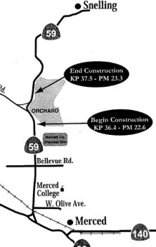 In June 2007, the CTC considered
a project in Merced County to make roadway improvements near Snelling (MER
22.6 to MER 23.3). This project is fully funded in the 2006 State Highway
Operation and Protection Program. The total estimated project cost is
$5,352,000. Construction is estimated to begin in Fiscal Year 2008-09. The
project will involve construction activities in the environmentally
sensitive habitat of the California tiger salamander and vernal pool fairy
shrimp, both federally listed threatened species. Due to these factors, a
Mitigated Negative Declaration is being completed for this project.
In June 2007, the CTC considered
a project in Merced County to make roadway improvements near Snelling (MER
22.6 to MER 23.3). This project is fully funded in the 2006 State Highway
Operation and Protection Program. The total estimated project cost is
$5,352,000. Construction is estimated to begin in Fiscal Year 2008-09. The
project will involve construction activities in the environmentally
sensitive habitat of the California tiger salamander and vernal pool fairy
shrimp, both federally listed threatened species. Due to these factors, a
Mitigated Negative Declaration is being completed for this project.
In June 2012, the CTC relinquished right of way in the county of Merced along Route 59 on Oakdale Road (~ MER 23.195), consisting of a collateral facility.
In January 2011, it was reported that the Tuolumne County Board of Supervisors is advocating for extending Route 59 from its current end (MER 33.71) along existing La Grange Road (Merced, Stanislaus, and Tuolumne County Sign Route J59) from Snelling to its terminus at the intersection of Route 108/Route 120. If they can get traction on this, Route 59 would no longer end out in the middle of nowhere. Tuolumne County Sign Route J59 was recently rejuvenated in Tuolumne county from a sub-par road to something resembling state highway standards in 2009-2010. If Caltrans takes it on now they would be adding a recently rebuilt road to the system and eliminate a dead end state highway. La Grange road already functions like a state highway by funneling traffic from Route 99 in Merced up Route 59 to County Sign Route J59 and into Tuolumne county, avoiding the need to travel into Stanislaus county on Route 99 and taking Route 108 east from Modesto. The intersection in Tuolumne county is in the vicinity of where Route 65 would likely travel if the unbuilt center section ever came to pass.
 Freeway
[SHC 253.1] Entire route. Added to the Freeway and Expressway system in 1959.
Status From Snelling, a County Sign Route J59 continues N to Route 120. This is likely
signed for continuity with Route 59.
From Snelling, a County Sign Route J59 continues N to Route 120. This is likely
signed for continuity with Route 59.
 Other WWW Links
 Statistics
Overall statistics for Route 59:
 Pre-1964 Legislative Route
The route that would become LRN 59 was first defined in the 1919 Third Bond Act as running from Lancaster to Baileys. It was an E-W routing from near Gorman to N of Lancaster, passing through Neenach. It was signed as Route 138 after 1934. "Bailey's" likely refers to the Bailey Ranch land, which was near Quail Lake (see this page on the Kinsey Ranch for a map). The Bailey Range was nearly 10,000 acres. According to the Ridge Route Museum, "In 1907 the Bailey family was “washed out” of their farm down near the present Pyramid Lake so they moved their beautiful two-story ranch house, with the help of two mules and a winch, in between Crane and Quail Lakes . The new location of the Bailey Ranch became a roadside rest stop for travelers through the area." This is likely the explanation of the reference to "Bailey's". It would correspond to where the Ridge Route is.
After 1959, a new routing for LRN 59 from about 10 mi E of Gorman through Lake Hughes directly to Palmdale was defined for Route 138 ("Metropolitan Bypass"), and the older routing from that point to Lancaster was renumbered LRN 267. Post 1964, the LRN 267 routing was renumbered as legislative Route 48, although it was signed as Route 138 (presumably, that signage would move once the bypass was completed). However, in 1996, the Route 138 to Lancaster portion of Route 48 was returned to Route 138, essentially restoring Route 138 back to the LRN 59 routing.
In 1931, Chapter 82 extended LRN 59 from [LRN 23] near Lancaster (US 6/Route 7, present-day Route 14) to [LRN 31] near Cajon Pass (US 91/US 66, present-day I-15). This was proposed as a short cut from San Bernardino to the San Joaquin valley or to the east Sierra route through Owens Valley to Lake Tahoe and Nevada. It continues the northwesterly direction of the San Bernardino county portion of LRN 31 passing over the Cajon Range through Phelan Pass and proceeding to Lancaster over level country; the coordinate route provides a straight course that justifies it as a essential through route.
In 1933, it was extended further, from [LRN 31] near Cajon Pass to [LRN 43] via Lake Arrowhead. It also incorporated a small portion of the original Ridge Route. In 1935, it was codified into the state highway code as follows:
In 1957, Chapter 36 changed the description and combined the first three segments, giving "[LRN 4] near Gorman to [LRN 31] near Cajon Pass"
This route was signed as follows:
This was signed as Sign Route 138. and corresponds to today's Los Angeles County Sign Route N2 (which was Route 138 until Route 48 was renumbered as Route 138). It also includes the proposed "Metropolitan Bypass" routing of Route 138 (unconstructed, and deleted in 1996), as well as what is present-day signed Route 138 (but legislative Route 48 between 1964 and 1996) between present-day Route 138 and Route 14. This was cosigned with Route 2 from near Phelan to the Cajon Pass.
This was signed as Sign Route 2 between Cajon Pass and Route 18 until 1964. This is present-day Route 138. Note that in this area, Route 173 corresponds to LRN 59, where the current Route 38 runs along LRN 188. That resignage occured in 1958.
© 1996-2020 Daniel P. Faigin.
Maintained by: Daniel P. Faigin
<webmaster@cahighways.org>.
 Route 58
 Route 60