
 California Highways:
Click here for a key to the symbols used. An explanation of acronyms may be found at the bottom of the page.
 Routing
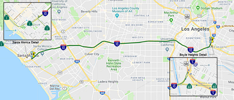 From Route 1 in Santa Monica to Route 5 near Seventh Street
in Los Angeles.
From Route 1 in Santa Monica to Route 5 near Seventh Street
in Los Angeles.
 Post 1964 Signage History
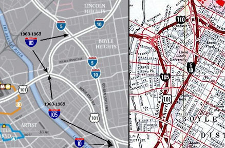 In 1963, this segment was defined as "Route 1
in Santa Monica to Route 105 near Soto Street."
In 1963, this segment was defined as "Route 1
in Santa Monica to Route 105 near Soto Street."
On January 5, 1966, the Santa Monica Freeway is completed, becoming the
western terminus of I-10.
(Source: Metro Primary Resources Blog, 1/5/2024)
In 1968, Chapter 385 changed the definitions of Route 105 ("from Route 5 to the junction of Route 110 (now part of Route 10) and US-101") and Route 110 ("from Route 105 to the junction of Routes 5 and 10") from their former stub routes in downtown, creating the present day I-105 routing. At this point, the definition of Route 10 was changed to "Route 1 in Santa Monica to Route 5 near Seventh Street in Los Angeles", and US 101 was changed to start at "Route 5 near Seventh Street in Los Angeles".
 Pre 1964 Signage History
 The segment was LRN 173, and was defined as part of the state
highway system since 1933; however, it was signed as Route 26 prior to the
freeway designation. Route 26 ran along Olympic Blvd. For information on
the route that was signed as Route 10, see below.
The segment was LRN 173, and was defined as part of the state
highway system since 1933; however, it was signed as Route 26 prior to the
freeway designation. Route 26 ran along Olympic Blvd. For information on
the route that was signed as Route 10, see below.
The McClure Tunnel opened on February 1, 1936, and originally connected the Roosevelt Highway (later, Pacific Coast Highway) with Lincoln Boulevard as part of US 101A. At one point, this was part of Sign Route 6. Note that technically the McClure tunnel (actually, the portion to the west of Lincoln Blvd) is part of Route 1, not Route 10.
The various state highway routes around this time (Sign Route 2 along Santa Monica, Sign Route 26 along Olympic, Sign Route 42 along Manchester) demonstrate that state was unsure what was the best route for the freeway. In a 1953 article on the Los Angeles freeway system, CHPW addressed this:
"One of the glaring defects indicated by the construction progress map is that it shows no activity upon a freeway extending westerly from the central business area of Los Angeles. We have long recognized the need for such freeway, but the overloaded condition of the Hollywood Freeway during its brief life of service has made it necessary that we reappraise the situation to determine whether a Santa Monica Freeway extending to the west, or a Venice-Olympic Freeway farther to the south, should be given priority, or whether it would be possible to determine upon some compromise route giving equal or better service. We have recently completed the initial phases of a traffic study for the entire western area, and are at the present time supplementing this by a vehicle use survey which will give us origin and destination data having a direct bearing upon the problem. Additional finances, if provided by the Legislature, should permit us to crystallize our thinking into action in providing the best facility possible for this very important area in this metropolitan district."
As history bore out, the choice was closer to the Venice-Olympic routing (but even a little S of that).
The first portion of I-10 (signed pre-1964 Route 26, LRN 175) to be adopted as freeway was a 9.6 mi segment between US 101 (Santa Ana Freeway) and La Cienega Blvd. This occured on 5/21/1954. The remainder of the route, from LaCienega to Lincoln Blvd (Route 1, LRN 60), was adopted as a freeway on November 15, 1956. The route recognized that one east-west freeway would have to serve West Los Angeles for many years, and the route chosen was one that provided the maximum traffic service. Work on the route was expected to start in 1957.
The California Highway Commission adopted 9.6 miles of the Olympic
Freeway on May 21, 1954. The adopted portion of the Olympic Freeway
was planned to span from the Santa Ana Freeway west to La Cienega
Boulevard as a new alignment of Route 26. In 1955, during the visit
with the California Highway Commission, the Los Angeles Chamber of
Commerce made a recommendation for the proposed Olympic Freeway as a new
limited-access corridor for LRN 173. The recommended corridor of the
Olympic Freeway was to begin at the Santa Ana Freeway and end 4.4-miles at
Hoover Street. In 1956, the corridor of the Olympic Freeway was
added as a chargeable corridor as a component of I-10.
(Source: Gribblenation Blog (Tom Fearer), "California State Route 6 and the second California State Route 26", 3/2023)
In June 1957, the groundbreaking ceremony commencing construction of the
Santa Monica Freeway at the Los Angeles River took place. By 1958, the
planned corridor of I-10 and the Santa Monica Freeway west of the Santa
Ana Freeway was being shown as part of LRN 173. In March 1962, the Santa
Monica Freeway and I-10 was opened to the Harbor Freeway. The newly
completed corridor of the Santa Monica Freeway completed an eastern bypass
loop of downtown Los Angeles, when paired with the Golden State
Freeway. By 1963, the completed segment of I-10 and the Santa Monica
Freeway east of the Harbor Freeway was showing on state highway maps, and
Sign Route 26 was truncated to existing solely on Olympic Boulevard west
of the Harbor Freeway.
(Source: Gribblenation Blog (Tom Fearer), "California State Route 6 and the second California State Route 26", 3/2023)
With the 1964 renumbering, Route 26 was reassigned to a segment of former
Sign Route 8 in the Sierra Nevada Mountains, and LRN 173 became a
component of I-10. The pre-1964 Sign Route 26 remained signed west of the
Harbor Freeway on Olympic Boulevard in interim as legislative spur of I-10
pending completion of the Santa Monica Freeway. By late 1964, I-10 and the
Santa Monica Freeway had been completed west to La Cienega Boulevard;
completion of I-10 west to Route 1 at Lincoln Boulevard was planned for
late 1965. Olympic Blvd was relinquished by 1967.
(Source: Gribblenation Blog (Tom Fearer), "California State Route 6 and the second California State Route 26", 3/2023)
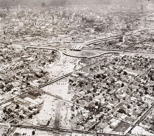 The KCET website has a nice article on the construction of I-10, with lots of nice pictures (including a larger version of the one to the right, which shows the I-10 under
construction in West Los Angeles. The article notes how the original
routes were planned along Santa Monica Blvd or Olympic (and later Venice,
with a onetime proposal for a raised freeway along the median of Venice).
It noted the current route was developed to avoid protesting
neighborhoods. The articles notes that construction crews broke ground on
the first segment of the newly renamed Santa Monica Freeway over the Los
Angeles River on June 17, 1957. Land acquisition for the freeway's
right-of-way began in 1958, and by 1961 families -- living in houses the
state had purchased and then rented back to their occupants -- received
orders to move. On December 4, 1961, Governor Edmund "Pat" Brown dedicated
the first, easternmost segment of the freeway as crews began work on the
route's West Los Angeles and Santa Monica portions. At its western
extreme, the freeway required a 7,000-foot-long, 20-foot-deep cut before
reaching the Pacific Coast Highway's McClure Tunnel. By October 1964,it
had been extended west to La Cienega Boulevard, and on January 29,
1965--several years after residents in the freeway's path were
displaced--the 4.5-mile segment between La Cienega and Bundy Drive opened.
The final segment through Santa Monica opened on January 5, 1965. The
article does not, alas, explain the design decision to build the freeway
as a raised structure as opposed to a depressed freeway (which might have
been less expensive).
The KCET website has a nice article on the construction of I-10, with lots of nice pictures (including a larger version of the one to the right, which shows the I-10 under
construction in West Los Angeles. The article notes how the original
routes were planned along Santa Monica Blvd or Olympic (and later Venice,
with a onetime proposal for a raised freeway along the median of Venice).
It noted the current route was developed to avoid protesting
neighborhoods. The articles notes that construction crews broke ground on
the first segment of the newly renamed Santa Monica Freeway over the Los
Angeles River on June 17, 1957. Land acquisition for the freeway's
right-of-way began in 1958, and by 1961 families -- living in houses the
state had purchased and then rented back to their occupants -- received
orders to move. On December 4, 1961, Governor Edmund "Pat" Brown dedicated
the first, easternmost segment of the freeway as crews began work on the
route's West Los Angeles and Santa Monica portions. At its western
extreme, the freeway required a 7,000-foot-long, 20-foot-deep cut before
reaching the Pacific Coast Highway's McClure Tunnel. By October 1964,it
had been extended west to La Cienega Boulevard, and on January 29,
1965--several years after residents in the freeway's path were
displaced--the 4.5-mile segment between La Cienega and Bundy Drive opened.
The final segment through Santa Monica opened on January 5, 1965. The
article does not, alas, explain the design decision to build the freeway
as a raised structure as opposed to a depressed freeway (which might have
been less expensive).
![[Reece at 405-10]](images/reece.jpg) The I-405/I-10 interchange was
designed by Marilyn Jorgenson Reece, who was the first woman in California
to be registered as a civil engineer, and the first woman to serve as an
associate highway engineer for the state. She died in May 2004. A South
Dakota native who earned a bachelor's degree in civil engineering from the
University of Minnesota in 1948, Reece moved to Los Angeles with her
parents shortly after graduation. The same year, she went to work for the
State Division of Highways, which later became Caltrans, as a junior civil
engineer in Los Angeles. In 1954, after six years of required experience
to sit for the Professional Engineer's Exam, Reece became the state's
first fully licensed female civil engineer. In 1962, she received the
Governor's Design Excellence Award from Gov. Pat Brown for the San
Diego-Santa Monica freeway interchange. Shortly after, Reece became the
Division of Highway's first woman resident engineer for construction
projects. The three-level San Diego-Santa Monica freeway interchange,
which opened in 1964, was the first interchange designed in California by
a woman engineer. With the aid of an early computer program, Reece plotted
the curves of its ramps and soaring, 75-foot-tall bridges to allow
automobiles to transition between freeways at 55 miles per hour -- a
significant speed increase over the tolerance of earlier interchanges,
like downtown's Four Level, which required cars to slow to 35 miles per
hour. Reece told The Los Angeles Times in 1995 that she put her "heart and
soul into it" and that she designed the interchange with aesthetics in
mind. "It is very airy. It isn't a cluttered, loopy thing," she said,
adding that specifications to keep traffic moving at high speeds
necessitated the long, sweeping curves. The image to the right, excerpted
from One Hundred Years of Progress, shows Reece and Thomas
McKinley. However, the book referred to Reece as an Associate Engineer,
with McKinley as a Resident Engineer, but did indicate that Reece
supervised the I-405/I-10 interchange project. The view in the photo is
looking N from what is roughly the National offramp on the I-405; you can
see a sign for the Route 26 Olympic Blvd NB offramp that was removed as
part of the project (likewise, the SB National offramp was removed)
The I-405/I-10 interchange was
designed by Marilyn Jorgenson Reece, who was the first woman in California
to be registered as a civil engineer, and the first woman to serve as an
associate highway engineer for the state. She died in May 2004. A South
Dakota native who earned a bachelor's degree in civil engineering from the
University of Minnesota in 1948, Reece moved to Los Angeles with her
parents shortly after graduation. The same year, she went to work for the
State Division of Highways, which later became Caltrans, as a junior civil
engineer in Los Angeles. In 1954, after six years of required experience
to sit for the Professional Engineer's Exam, Reece became the state's
first fully licensed female civil engineer. In 1962, she received the
Governor's Design Excellence Award from Gov. Pat Brown for the San
Diego-Santa Monica freeway interchange. Shortly after, Reece became the
Division of Highway's first woman resident engineer for construction
projects. The three-level San Diego-Santa Monica freeway interchange,
which opened in 1964, was the first interchange designed in California by
a woman engineer. With the aid of an early computer program, Reece plotted
the curves of its ramps and soaring, 75-foot-tall bridges to allow
automobiles to transition between freeways at 55 miles per hour -- a
significant speed increase over the tolerance of earlier interchanges,
like downtown's Four Level, which required cars to slow to 35 miles per
hour. Reece told The Los Angeles Times in 1995 that she put her "heart and
soul into it" and that she designed the interchange with aesthetics in
mind. "It is very airy. It isn't a cluttered, loopy thing," she said,
adding that specifications to keep traffic moving at high speeds
necessitated the long, sweeping curves. The image to the right, excerpted
from One Hundred Years of Progress, shows Reece and Thomas
McKinley. However, the book referred to Reece as an Associate Engineer,
with McKinley as a Resident Engineer, but did indicate that Reece
supervised the I-405/I-10 interchange project. The view in the photo is
looking N from what is roughly the National offramp on the I-405; you can
see a sign for the Route 26 Olympic Blvd NB offramp that was removed as
part of the project (likewise, the SB National offramp was removed)
Some nice pictures of the construction of this route may be found on the KCET website. Additional pictures may be found in theUSC Digital Archives.
Construction on the Santa Monica Freeway portion of I-10 was completed in January 1966.
 Status
Technically Route 1 Portion (W of 7th Street)
In January 2017, it was reported that the City of Santa Monica was
considering the Gateway Master Plan, which will address planning in the
area “adjacent to the I-10 Freeway that links Downtown to the Civic
Center” and to Santa Monica High School, and it could include
covering the freeway with decking that could create new space for a park
(this appears to include the portion of the freeway that, although
considered I-10, is really Route 1). Previous reports on capping the park
had explored extending the McClure Tunnel and covering the 10 freeway from
Fourth Street (001 LA 35.037) to Ocean Avenue (001 LA 35.11). The new
staff report says the Gateway Master Plan offers “a unique
opportunity for strengthening connections over the freeway right of
way.” It also says the cap park would be a way to offer “an
enlarged green space for outdoor enjoyment” where there previously
was none. By removing the visual and physical barrier between the
city’s downtown and its civic center area, the park could create a
new link between the two sections of the city. The report also notes that
by providing access to “peripheral parking opportunities,” the
park might be able to reduce car congestion in the city’s downtown.
(Source: CurbedLA, 1/8/2018)
A (temporary) installation of a statue of Mario of the Mario Brothers has
been installed atop a column on I-10 freeway (actually, Route 1, as the
visible location is ~ 001 LA R34.812) in Santa Monica. The character is
visible from the corner of Olympic and 5th Street and to
vehicles entering the freeway at that intersection. It is the work of
Bohemia Incorporated and the arts duo said the location had been on their
radar for years but it took some time to figure out what to put there. The
Styrofoam sculpture is about 32 inches tall and is painted to match the
concrete it sits atop.
(Source: Santa Monica Daily Press, 7/22/17)
I-10 Portion (E of 7th Street, Santa Monica)
In June 2017, there was a report on the artists that have installed a
lone mermaid, casually swimming along a retaining wall on WB I-10 in the
vicinity of Cheviot Hills (approximately 010 LA R6.612). The mermaid (she
has no official title) turns out to be the work of a street art collective
known as Bohemia Incorporated. For a couple of years, the group has been illicitly installing three-dimensional sculptures around Los Angeles — in the
dead public spaces at freeway intersections and on freeway retaining
walls. Some last for hours (such as one that featured a paint brush and
the phrase “Don’t worry I pay taxes”), others run for
months (such as the sculpture of a woman taking a selfie on the 5 Freeway
in Silver Lake). But the mermaid has been in place for more than two
years. One of the artists for Bohemia Incorporated, also known as #binc,
says the group’s sculptures are generally made from Styrofoam, then
painted to resemble concrete.
(Source: LA Times, 6/20/2017)
Robertson/National Interchange
The SAFETEA-LU act, enacted in August 2005 as the reauthorization of TEA-21, provided the following expenditures on or near this route:
In March 2018, it was reported that LADOT is partering
with the City of Culver City and Caltrans to improve the confusing
on-ramps and off-ramps near Robertson and National Blvds. The goal will be
to hopefully make commuting easier for people choosing to take the train
to avoid it. According to an LADOT release, the I-10/Robertson/National
Area Circulation Improvement Project will upgrade the Robertson and
National onramps and offramps in a way that will improve the experience
for drivers and transit users. The goal is to “simplify traffic
movements, and minimize traffic impacts from the Culver City Expo Station
and other new developments in the area.” In addition, the crossings
will make streets much safer for pedestrians and cyclists, who are using
these same poorly designed connections to walk to the Culver City Expo
line stop and access the Expo bike path. The project team has been
conducting outreach since the fall of 2016, according to a presentation posted by LADOT. The project site shows four potential design alternatives that reconfigure the offramps to smooth congestion and redesign streets to give people who live north of I-10 more
pleasant walks to the train.
(Source: Curbed LA, 3/7/2018)
In June 2017, there was an interesting article on the "Crenshaw Cowboy of
the Wild West", an itinerant artist living on the WB onramp of I-10 at
Crenshaw (approx. 010 LA R11.371). The artist, Kenneth Lovell Moore, or
just Lovell, constructs sculptures from discarded script. When Moore
isn’t creating these galactic sculptures or asking drivers for
donations so he can buy art supplies, he’s dancing like his favorite
performer: Michael Jackson.
(Source: KPCC, 6/9/2017)
 Commuter Lanes
 HOV lanes were planned/are constructed as follows:
In March 1976, the Southern California Rapid Transit District (SCRTD) launched the Santa Monica Freeway Diamond Lane Express project. The project, administered by the California Department of Transportation and funded by a grant from the federal government, reserves the inside, or “fast,” lane for use of high-occupancy vehicles including buses, carpools and vans. In this project, the inside lane was reserved from 6 a.m. to 10 a.m. and from 3 p.m. to 7 p.m. Monday through Friday in both directions over the 12-mile stretch between Lincoln Boulevard in Santa Monica and the Harbor Freeway in downtown Los Angeles. The project was the first of its kind in the nation, and was designed to increase the people-moving capacity of the freeway by creating incentives for high-occupancy vehicle use. Carpools with two or more passengers were able to utilize priority onramps at several locations along the freeway to bypass the single-occupant vehicles lined up at ramp meters. The westbound priority onramps include Hoover Street, Vermont Avenue, Western Avenue, Crenshaw Boulevard and Fairfax Avenue. Eastbound priority ramps include Cloverfield Boulevard, Bundy Drive, Manning Avenue, Venice Boulevard, Crenshaw Boulevard, Western Avenue and Vermont. The Flower Street onramp to the northbound Harbor Freeway near Adams which leads directly into the westbound Diamond lane has been reopened, but only carpools and buses will use it.
An evaluation of the lanes published by the Transportation Research Board
noted that the project succeeded in increasing carpool ridership by 65%
and the increased bus service accompanying the Diamond Lanes caused bus
ridership to more than triple. Nonetheless, energy savings and air quality
improvements were insignificant, freeway accidents increased
significantly, non-carpoolers lost far more time than carpoolers gained,
and a heated public outcry developed that delayed the implementation of
other preferential treatment projects in Southern California and gave
planners and public officials in other areas ample cause for reflection
before attempting to implement similar projects.
(Source: Billheimer, J W, Bullemer, R J, and Fratessa, C. The Santa Monica freeway diamond lanes. Volume I. Summary. Final report, March 1976-August 1976. United States: N. p., 1977. Web.)
The lanes operated for 21 weeks until the U.S. District Court halted the
project. The fatal flaw was that the Diamond Lane was not a new one, but
an existing lane removed from general traffic flow. The result was an
almost-empty Diamond Lane, including a few cheaters, and incredible
traffic tie-ups in the lanes left to everyone else. This led to a change
in policy whereby new lanes would be created; existing lanes would not be
converted. In 1990, Proposition 111 was proposed to bring back HOV lanes
under this new philosophy. Proposition 111 would create new
gasoline-tax revenue--resulting from a doubling of the 9-cent-per-gallon
fuel levy over five years--that would finance more than $500 million worth
of HOV lane construction in Los Angeles, San Diego and Orange counties.
Projects likely to get assistance included an extension of the El Monte
Busway along I-10 east of downtown Los Angeles, and HOV lanes on these
freeways: Route 60, Route 118 and I-405--and probably Route 91 and Route 210--in Los Angeles County; I-5 and I-15 in San Diego County, and Route 57
in Los Angeles and Orange counties. The biggest project of all would be
$186 million in HOV lane construction along the entire length of I-405 in
Los Angeles County, from the San Fernando Valley to Long Beach.
(Source: LA Times, 4/9/1990)
 Naming
 This portion is named the "Santa Monica Freeway"; the first segment opened in 1961 and the freeway was
completed in 1966. It was named by the State Highway Commission on April
25, 1957. The name derives from the western terminus of the segment in the
City of Santa Monica. The name Santa Monica may have been applied
by the second Portolá expedition on May 4, 1770, the day of holy
Monica, mother of Saint Augustine. It appears in 1839 in the land grant
San Vicente y Santa Monica, on which the modern city was founded in the
early 1870s. Sierra de Santa Monica was recorded in 1822.
This portion is named the "Santa Monica Freeway"; the first segment opened in 1961 and the freeway was
completed in 1966. It was named by the State Highway Commission on April
25, 1957. The name derives from the western terminus of the segment in the
City of Santa Monica. The name Santa Monica may have been applied
by the second Portolá expedition on May 4, 1770, the day of holy
Monica, mother of Saint Augustine. It appears in 1839 in the land grant
San Vicente y Santa Monica, on which the modern city was founded in the
early 1870s. Sierra de Santa Monica was recorded in 1822.
(Image source: Quora)
The route was originally to have been named the "Olympic Freeway"; that name was changed during planning in 1958. That probably came from the original Route 26 routing along Olympic Blvd, which itself was renamed from 10th Street in honor of the 1932 Olympics.
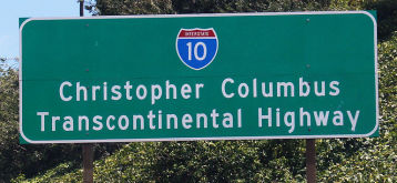 In additional to the other designations noted, between 1976 and 2022, Route 10 (in its
entirety) was officially designated the "Christopher Columbus
Transcontinental Highway", although on the east coast, the
corresponding sign was not on I-10 (it is on I-40). It was named because,
at the time, I-10 was not named after any historical figure, it was the
bicentennial year, and the legislature wanted to give recognition in a
“concrete” way to those great persons who they felt
contributed to the development of this country. They chose Columbus
because (in their words at the time) "To millions of Americans, the name
of Christopher Columbus represents a man whose name is enshrined forever
in the hearts and minds of people as a navigator of undaunted skill and
perseverance whose discovery of America opened the Western Hemisphere to a
new dawn of civilization". It was named by Assembly Concurrent Resolution (ACR) 106, Chapter 71, in 1976. According to reports in 2003, the sign on I-10 has disappeared. However, in 2022, ACR 177, Chapter 175, 09/13/22, the legislature request that the
Department of Transportation remove the “Christopher Columbus
Transcontinental Highway” designation from the portion of
I-10 in the state, as well as any signage and markers memorializing that
designation, and advise the Federal Highway Administration of the
state’s action. This is because in the period since the original
naming in 1976, our understanding of Columbus and his role has changed. As
of 2022, it is widely and accurately accepted that Christopher Columbus
did not “discover” America. Further, Columbus provided the
impetus for European colonization of North America; and that colonization
and conquest led directly to the confiscation of land from indigenous
people, displacement, and enslavement. Millions of indigenous people
suffered violent death from the conquest, disease, and forced slave labor.
In light of this, and in light of the state's responsibility to promote
and enhance safety for all residents and uplift truth, dignity, and
justice for all, the designation was removed, effectively overturning and
reversing ACR 106 (Resolution Chapter 71) of the Statutes of 1976.
In additional to the other designations noted, between 1976 and 2022, Route 10 (in its
entirety) was officially designated the "Christopher Columbus
Transcontinental Highway", although on the east coast, the
corresponding sign was not on I-10 (it is on I-40). It was named because,
at the time, I-10 was not named after any historical figure, it was the
bicentennial year, and the legislature wanted to give recognition in a
“concrete” way to those great persons who they felt
contributed to the development of this country. They chose Columbus
because (in their words at the time) "To millions of Americans, the name
of Christopher Columbus represents a man whose name is enshrined forever
in the hearts and minds of people as a navigator of undaunted skill and
perseverance whose discovery of America opened the Western Hemisphere to a
new dawn of civilization". It was named by Assembly Concurrent Resolution (ACR) 106, Chapter 71, in 1976. According to reports in 2003, the sign on I-10 has disappeared. However, in 2022, ACR 177, Chapter 175, 09/13/22, the legislature request that the
Department of Transportation remove the “Christopher Columbus
Transcontinental Highway” designation from the portion of
I-10 in the state, as well as any signage and markers memorializing that
designation, and advise the Federal Highway Administration of the
state’s action. This is because in the period since the original
naming in 1976, our understanding of Columbus and his role has changed. As
of 2022, it is widely and accurately accepted that Christopher Columbus
did not “discover” America. Further, Columbus provided the
impetus for European colonization of North America; and that colonization
and conquest led directly to the confiscation of land from indigenous
people, displacement, and enslavement. Millions of indigenous people
suffered violent death from the conquest, disease, and forced slave labor.
In light of this, and in light of the state's responsibility to promote
and enhance safety for all residents and uplift truth, dignity, and
justice for all, the designation was removed, effectively overturning and
reversing ACR 106 (Resolution Chapter 71) of the Statutes of 1976.
(Image source: Wikipedia)
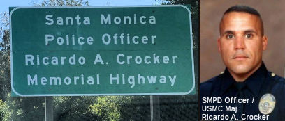 The portion of I-10 within the city limits of Santa Monica (~ 010
LA 0.0/R4.334) is named the "Ricardo A. Crocker Memorial Highway".
This segment was named in memory of Santa Monica Police Officer Ricardo A.
Crocker, a Major in the United States Marine Corps, who was killed by a
rocket propelled grenade explosion on May 26, 2005 while conducting combat
operations against enemy forces in Iraq. Ricardo A. Crocker was assigned
to Detachment D, Third Civil Affairs Group, attached to the Fifth
Provisional Civil Affairs Group II MEF and had previously served in
Operation Iraqi Freedom II with the Third Civil Affairs Group from
February through September 2004, and was redeployed to Iraq with the Fifth
Provisional Civil Affairs Group in February 2005. At the time of his
death, Ricardo A. Crocker, known as "Rick," was 39 years of age and a
10-year veteran of the Santa Monica Police Department. Ricardo A. Crocker
held the rank of Captain in the United States Marine Corps when he was
hired by the Santa Monica Police Department on July 21, 1995, subsequently
being promoted to the rank of Major in the Marine Corps. As an Officer for
the Santa Monica Police Department, Ricardo A. Crocker served in uniform
patrol and was a member of the Crime Impact Team and Special Entry Team,
serving as the primary emergency medical technician for the Special Entry
Team, and was a rifle team member and rifle instructor. While in his final
assignment to the Police Activities League, Officer Crocker made an
indelible impression on the youth of Santa Monica by teaching preparatory
courses for the Scholastic Aptitude Test, leading the book club, and
implementing hiking and camping programs that exposed these youth to his
two passions: education and nature. Ricardo A. Crocker was an excellent
officer and ambassador for the Santa Monica Police Department as well as
an excellent protector of the community; was a consummate caring
professional who represented the highest standards and traditions of law
enforcement and the Santa Monica Police Department. Named by Senate
Concurrent Resolution (SCR) 20, Resolution Chapter 94, on 7/12/2007.
The portion of I-10 within the city limits of Santa Monica (~ 010
LA 0.0/R4.334) is named the "Ricardo A. Crocker Memorial Highway".
This segment was named in memory of Santa Monica Police Officer Ricardo A.
Crocker, a Major in the United States Marine Corps, who was killed by a
rocket propelled grenade explosion on May 26, 2005 while conducting combat
operations against enemy forces in Iraq. Ricardo A. Crocker was assigned
to Detachment D, Third Civil Affairs Group, attached to the Fifth
Provisional Civil Affairs Group II MEF and had previously served in
Operation Iraqi Freedom II with the Third Civil Affairs Group from
February through September 2004, and was redeployed to Iraq with the Fifth
Provisional Civil Affairs Group in February 2005. At the time of his
death, Ricardo A. Crocker, known as "Rick," was 39 years of age and a
10-year veteran of the Santa Monica Police Department. Ricardo A. Crocker
held the rank of Captain in the United States Marine Corps when he was
hired by the Santa Monica Police Department on July 21, 1995, subsequently
being promoted to the rank of Major in the Marine Corps. As an Officer for
the Santa Monica Police Department, Ricardo A. Crocker served in uniform
patrol and was a member of the Crime Impact Team and Special Entry Team,
serving as the primary emergency medical technician for the Special Entry
Team, and was a rifle team member and rifle instructor. While in his final
assignment to the Police Activities League, Officer Crocker made an
indelible impression on the youth of Santa Monica by teaching preparatory
courses for the Scholastic Aptitude Test, leading the book club, and
implementing hiking and camping programs that exposed these youth to his
two passions: education and nature. Ricardo A. Crocker was an excellent
officer and ambassador for the Santa Monica Police Department as well as
an excellent protector of the community; was a consummate caring
professional who represented the highest standards and traditions of law
enforcement and the Santa Monica Police Department. Named by Senate
Concurrent Resolution (SCR) 20, Resolution Chapter 94, on 7/12/2007.
(Image source: SMPD on Twitter)
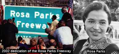 The segment between I-405 and Route 110 (~ 010 LA R5.455/LA 14.82) is named the "Rosa
Parks Freeway". Rosa Parks (born February 4, 1913, in Tuskegee,
Alabama) is considered the "Mother of the Modern Day Civil Rights
Movement". This fame started when she was arrested on December 1, 1955, in
Montgomery, Alabama, for refusing to give up her seat on a bus to a white
man. Her arrest was the impetus for a boycott of Montgomery buses, led by
Dr. Martin Luther King, Jr., and joined by approximately 42,000 African
Americans for 381 days. On November 13, 1956, the United States Supreme
Court ruled that Montgomery's segregation law was unconstitutional, and on
December 20, 1956, Montgomery officials were ordered to desegregate buses.
Rosa Parks refusal to surrender her seat in compliance with Montgomery's
segregation law inspired the civil rights movement, which has resulted in
the breakdown of numerous legal barriers and the lessening of profound
discrimination against African Americans in this country. Her courage and
conviction laid the foundation for equal rights for all Americans and for
the Civil Rights Act of 1964. Rosa Parks was the first woman to join the
Montgomery chapter of the NAACP, and was an active volunteer for the
Montgomery Voters League. She cofounded the Rosa and Raymond Parks
Institute for Self Development in 1987 with Elaine Easton Steele to
motivate and direct youth to achieve their highest potential through the
"Pathways to Freedom" program. She is the recipient of many awards
including the Presidential Medal of Freedom, the nation's highest civilian
honor, the Congressional Gold Medal of Honor, the highest honor Congress
can bestow upon a civilian, and the first International Freedom Conductor
Award from the National Underground Railroad Freedom Center. The naming
was on the occation of Rosa Park's 89th birthday. Named by
Assembly Concurrent Resolution 134, Chapter 2, 28 January 2002.
The segment between I-405 and Route 110 (~ 010 LA R5.455/LA 14.82) is named the "Rosa
Parks Freeway". Rosa Parks (born February 4, 1913, in Tuskegee,
Alabama) is considered the "Mother of the Modern Day Civil Rights
Movement". This fame started when she was arrested on December 1, 1955, in
Montgomery, Alabama, for refusing to give up her seat on a bus to a white
man. Her arrest was the impetus for a boycott of Montgomery buses, led by
Dr. Martin Luther King, Jr., and joined by approximately 42,000 African
Americans for 381 days. On November 13, 1956, the United States Supreme
Court ruled that Montgomery's segregation law was unconstitutional, and on
December 20, 1956, Montgomery officials were ordered to desegregate buses.
Rosa Parks refusal to surrender her seat in compliance with Montgomery's
segregation law inspired the civil rights movement, which has resulted in
the breakdown of numerous legal barriers and the lessening of profound
discrimination against African Americans in this country. Her courage and
conviction laid the foundation for equal rights for all Americans and for
the Civil Rights Act of 1964. Rosa Parks was the first woman to join the
Montgomery chapter of the NAACP, and was an active volunteer for the
Montgomery Voters League. She cofounded the Rosa and Raymond Parks
Institute for Self Development in 1987 with Elaine Easton Steele to
motivate and direct youth to achieve their highest potential through the
"Pathways to Freedom" program. She is the recipient of many awards
including the Presidential Medal of Freedom, the nation's highest civilian
honor, the Congressional Gold Medal of Honor, the highest honor Congress
can bestow upon a civilian, and the first International Freedom Conductor
Award from the National Underground Railroad Freedom Center. The naming
was on the occation of Rosa Park's 89th birthday. Named by
Assembly Concurrent Resolution 134, Chapter 2, 28 January 2002.
(Image source: Councilman Nate Holden; TheNegro
Woman in History Blog)
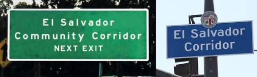 In September 2019, it was noted that signs have been installed near Vermont Avenue (~ LA R13.82) to direct
drivers to the El Salvador Community Corridor. This comes six years after the 2013 designation of the 12 blocks of Vermont Avenue from 11th
Street to Adams Street as the corridor. Even though the Salvadoran
community has largely settled in Pico-Union and Westlake, around 30 years
ago Vermont Avenue became attractive to Salvadorans for one reason alone:
banks. Banks like Banco Agricola, Banco Cuscatlan, and Banco American
Central were crucial for Salvadorans who wanted to send funds back to
family in El Salvador. Over the decades, parts of Vermont Avenue became a
center for the Salvadoran community when street vendors, meat markets, and
restaurants followed the crowds of expats. Oscar Dominguez, founder and
president of El Salvador Community Corridor believes that the corridor has
given Salvadorans a place in the city and that the new signage will
motivate Angelenos to visit the artery and support one (or more) of the
150 Salvadoran businesses located there.
In September 2019, it was noted that signs have been installed near Vermont Avenue (~ LA R13.82) to direct
drivers to the El Salvador Community Corridor. This comes six years after the 2013 designation of the 12 blocks of Vermont Avenue from 11th
Street to Adams Street as the corridor. Even though the Salvadoran
community has largely settled in Pico-Union and Westlake, around 30 years
ago Vermont Avenue became attractive to Salvadorans for one reason alone:
banks. Banks like Banco Agricola, Banco Cuscatlan, and Banco American
Central were crucial for Salvadorans who wanted to send funds back to
family in El Salvador. Over the decades, parts of Vermont Avenue became a
center for the Salvadoran community when street vendors, meat markets, and
restaurants followed the crowds of expats. Oscar Dominguez, founder and
president of El Salvador Community Corridor believes that the corridor has
given Salvadorans a place in the city and that the new signage will
motivate Angelenos to visit the artery and support one (or more) of the
150 Salvadoran businesses located there.
(Source: LA Magazine, 9/17/2019; Image source: El Salvador Community Corridor Facebook Page)
 Named Structures
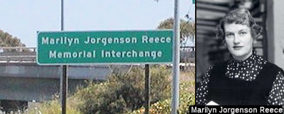 The I-405/I-10 Interchange (~ 010 LA R5.455)
is named the "Marilyn Jorgenson Reece Memorial Interchange". It was
named in honor of Marilyn Jorgenson Reece, who was born and raised in
North Dakota and earned a bachelor's degree in civil engineering from the
University of Minnesota in 1948. Ms. Reece moved to Los Angeles with her
parents shortly after graduation in 1948, and went to work for the State
Division of Highways, which later became the Department of Transportation,
as a junior civil engineer in Los Angeles. After six years of experience
required to sit for the Professional Engineers Exam, Marilyn Jorgenson
Reece became the state's first fully licensed female civil engineer in
1954. In 1962, Marilyn Jorgenson Reece received the Governor's Design
Excellence Award from Governor Pat Brown for designing the I-10/I-405
interchange. Ms. Reece became the Division of Highway's first woman
resident engineer for construction projects shortly after receiving that
award. The three-level I-10/I-405 interchange designed by Marilyn
Jorgenson Reece opened in 1964 and was the first interchange designed in
California by a woman engineer. Urban critic Reyner Banham, author of Los
Angeles: The Architecture of Four Ecologies, admired the
wide-swinging curved ramps connecting the two freeways, and wrote that the
I-10/I-405 interchange "is a work of art, both as a pattern on the map, as
a monument against the sky, and as a kinetic experience as one sweeps
through it". During her 35-year career, Marilyn Jorgenson Reece's projects
included serving as senior engineer for the completion of Route 210
through Sunland in 1975—at the time, the largest construction
project the Department of Transportation had ever awarded—at $40
million. After retiring in 1983, Marilyn Jorgenson Reece taught
engineering classes at Cal State Long Beach; and during Women's History
Month in 1983, the Los Angeles City Council honored Marilyn Jorgenson
Reece for making significant contributions to the city. In 1991, Marilyn
Jorgenson Reece received life membership in the American Society of Civil
Engineers. Named by Senate Concurrent Resolution (SCR) 72, Resolution
Chapter 96, on 8/15/2006.
The I-405/I-10 Interchange (~ 010 LA R5.455)
is named the "Marilyn Jorgenson Reece Memorial Interchange". It was
named in honor of Marilyn Jorgenson Reece, who was born and raised in
North Dakota and earned a bachelor's degree in civil engineering from the
University of Minnesota in 1948. Ms. Reece moved to Los Angeles with her
parents shortly after graduation in 1948, and went to work for the State
Division of Highways, which later became the Department of Transportation,
as a junior civil engineer in Los Angeles. After six years of experience
required to sit for the Professional Engineers Exam, Marilyn Jorgenson
Reece became the state's first fully licensed female civil engineer in
1954. In 1962, Marilyn Jorgenson Reece received the Governor's Design
Excellence Award from Governor Pat Brown for designing the I-10/I-405
interchange. Ms. Reece became the Division of Highway's first woman
resident engineer for construction projects shortly after receiving that
award. The three-level I-10/I-405 interchange designed by Marilyn
Jorgenson Reece opened in 1964 and was the first interchange designed in
California by a woman engineer. Urban critic Reyner Banham, author of Los
Angeles: The Architecture of Four Ecologies, admired the
wide-swinging curved ramps connecting the two freeways, and wrote that the
I-10/I-405 interchange "is a work of art, both as a pattern on the map, as
a monument against the sky, and as a kinetic experience as one sweeps
through it". During her 35-year career, Marilyn Jorgenson Reece's projects
included serving as senior engineer for the completion of Route 210
through Sunland in 1975—at the time, the largest construction
project the Department of Transportation had ever awarded—at $40
million. After retiring in 1983, Marilyn Jorgenson Reece taught
engineering classes at Cal State Long Beach; and during Women's History
Month in 1983, the Los Angeles City Council honored Marilyn Jorgenson
Reece for making significant contributions to the city. In 1991, Marilyn
Jorgenson Reece received life membership in the American Society of Civil
Engineers. Named by Senate Concurrent Resolution (SCR) 72, Resolution
Chapter 96, on 8/15/2006.
(Image source: PBWorks)
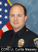 The eastbound portion of the National Boulevard overpass (~ 010 LA R006.40, although it coule be R007.21) is
named the "Culver City Police Lieutenant Curtis Massey Memorial
Overpass". This segment was named in honor of Lieutenant Curtis
Massey of the Culver City Police Department, who died on January 28, 2009
when his unmarked vehicle was struck head-on by a vehicle driven the wrong
way on I-10 near National Boulevard in the City of Los Angeles. Massey was
born on June 1, 1967, the son of Stephen Massey and Padric Davis of
Pacific Palisades. Massey attended Saint Matthews School and Palisades
High School, graduating as part of the class of 1985. In those early
years, Massey was a role model to many and was instrumental in the lives
of young children through his job as a summer camp counselor at St.
Matthews Day Camp. Massey furthered his education at Northern Arizona
University where he received his bachelor's degree. In addition to his
collegiate work, Massey devoted himself, again, to helping others as part
of the Flagstaff EMT unit. That devotion to helping others led Massey to a
career in law enforcement. Accordingly, Massey graduated from the Los
Angeles County Sheriff's Academy in 1992. Massey devoted his life to his
family and the public, particularly at-risk youths. Beginning as a patrol
officer, Lieutenant Massey served with distinction during his 17-year
career in a variety of assignments within the Culver City Police
Department; most notably with the juvenile section of the detective
bureau, specifically the juvenile diversion program. During that time,
Massey's admirable drive to protect and serve the public, and his
dedication to duty, led Massey to be honored as "Officer of the Year"
three times within the Culver City Police Department. Massey was also a
recipient of the "Medal of Valor," the department's highest honor.
Lieutenant Massey had recently been assigned as the supervisor of the
juvenile detective section, and spent a lot of his own free time working
with at-risk children. Named by Assembly Concurrant Resolution (ACR) 124,
8/30/2010, Resolution Chapter 109.
The eastbound portion of the National Boulevard overpass (~ 010 LA R006.40, although it coule be R007.21) is
named the "Culver City Police Lieutenant Curtis Massey Memorial
Overpass". This segment was named in honor of Lieutenant Curtis
Massey of the Culver City Police Department, who died on January 28, 2009
when his unmarked vehicle was struck head-on by a vehicle driven the wrong
way on I-10 near National Boulevard in the City of Los Angeles. Massey was
born on June 1, 1967, the son of Stephen Massey and Padric Davis of
Pacific Palisades. Massey attended Saint Matthews School and Palisades
High School, graduating as part of the class of 1985. In those early
years, Massey was a role model to many and was instrumental in the lives
of young children through his job as a summer camp counselor at St.
Matthews Day Camp. Massey furthered his education at Northern Arizona
University where he received his bachelor's degree. In addition to his
collegiate work, Massey devoted himself, again, to helping others as part
of the Flagstaff EMT unit. That devotion to helping others led Massey to a
career in law enforcement. Accordingly, Massey graduated from the Los
Angeles County Sheriff's Academy in 1992. Massey devoted his life to his
family and the public, particularly at-risk youths. Beginning as a patrol
officer, Lieutenant Massey served with distinction during his 17-year
career in a variety of assignments within the Culver City Police
Department; most notably with the juvenile section of the detective
bureau, specifically the juvenile diversion program. During that time,
Massey's admirable drive to protect and serve the public, and his
dedication to duty, led Massey to be honored as "Officer of the Year"
three times within the Culver City Police Department. Massey was also a
recipient of the "Medal of Valor," the department's highest honor.
Lieutenant Massey had recently been assigned as the supervisor of the
juvenile detective section, and spent a lot of his own free time working
with at-risk children. Named by Assembly Concurrant Resolution (ACR) 124,
8/30/2010, Resolution Chapter 109.
(Image source: Culver City Observer)
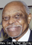 The Western Avenue overcrossing at I-10 (~ 010 LA
R12.825), in the City of Los Angeles, is officially named the Reverend
Cecil "Chip" Murray Overcrossing. It was named in honor of the
Reverend Cecil "Chip" Murray, who has generously and successfully served
the community and congregation of the First African Methodist Episcopal
Church in Los Angeles since 1977, when the congregation counted 300 active
members and those members received his vision to ignite a fire in their
hearts to be a church that extends beyond its walls. As of 2004, the
congregation numbered over 17,300 members, and works through more than 40
task forces, including task forces related to health, substance abuse,
homelessness, emergency food and clothing, general and specialized
housing, tutoring, entrepreneurial training, and employment services.
These task forces and programs provide notable assistance and services
that include assistance and services for the physically handicapped,
dwelling assistance for low-income individuals and those with HIV/AIDS,
transportation for the elderly and handicapped, education, health care and
AIDS/tobacco ministries, tutoring, legal aid, computer training, job
training and placement, economic development and loan programs, a business
incubator for multimedia production, a prison ministry, environmental
programs, food programs, youth programs, choir and music programs, and
other activities. Reverend Murray served 10 years on active duty in the
United States Air Force as a jet radar intercept officer in the Air
Defense Command and as a navigator in the Air Transport Command, was
decorated in 1958 with the Soldier's Medal of Valor following an explosion
in his two-seated fighter, and retired as a reserve major in the United
States Air Force. He is a native of Florida and has received an
undergraduate degree from Florida A&M University, has received a
doctorate in religion from the School of Theology at Claremont, and has
lectured and been an adjunct professor at Iliff University, Seattle
University, the School of Theology at Claremont, Fuller Seminary, and
Northwest Theological Seminary. Reverend Murray retired as Senior Pastor
of the First African Methodist Episcopal Church on September 25, 2004.
Named by Assembly Concurrent Resolution 152, chaptered September 1, 2004.
Resolution Chapter 175.
The Western Avenue overcrossing at I-10 (~ 010 LA
R12.825), in the City of Los Angeles, is officially named the Reverend
Cecil "Chip" Murray Overcrossing. It was named in honor of the
Reverend Cecil "Chip" Murray, who has generously and successfully served
the community and congregation of the First African Methodist Episcopal
Church in Los Angeles since 1977, when the congregation counted 300 active
members and those members received his vision to ignite a fire in their
hearts to be a church that extends beyond its walls. As of 2004, the
congregation numbered over 17,300 members, and works through more than 40
task forces, including task forces related to health, substance abuse,
homelessness, emergency food and clothing, general and specialized
housing, tutoring, entrepreneurial training, and employment services.
These task forces and programs provide notable assistance and services
that include assistance and services for the physically handicapped,
dwelling assistance for low-income individuals and those with HIV/AIDS,
transportation for the elderly and handicapped, education, health care and
AIDS/tobacco ministries, tutoring, legal aid, computer training, job
training and placement, economic development and loan programs, a business
incubator for multimedia production, a prison ministry, environmental
programs, food programs, youth programs, choir and music programs, and
other activities. Reverend Murray served 10 years on active duty in the
United States Air Force as a jet radar intercept officer in the Air
Defense Command and as a navigator in the Air Transport Command, was
decorated in 1958 with the Soldier's Medal of Valor following an explosion
in his two-seated fighter, and retired as a reserve major in the United
States Air Force. He is a native of Florida and has received an
undergraduate degree from Florida A&M University, has received a
doctorate in religion from the School of Theology at Claremont, and has
lectured and been an adjunct professor at Iliff University, Seattle
University, the School of Theology at Claremont, Fuller Seminary, and
Northwest Theological Seminary. Reverend Murray retired as Senior Pastor
of the First African Methodist Episcopal Church on September 25, 2004.
Named by Assembly Concurrent Resolution 152, chaptered September 1, 2004.
Resolution Chapter 175.
(Image source: LA Sentinal, 10/26/2011)
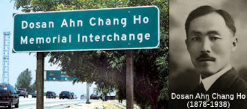 The I-10/I-110 interchange (~ 010 LA 14.83) is officially
named the "Dosan Ahn Chang Ho Memorial Interchange". Dosan Ahn
Chang Ho was born in a small village in Korea in 1878. He arrived in
America in 1902 with his newlywed wife, Lee Hae Ryon (Helen Ahn). As the
steamship approached Hawaii, Ahn Chang Ho resolved to stand tall above the
sea of turmoil existing at that time in Korea, and resolved to call
himself "Dosan," which means Island Mountain. While living in San
Francisco, Dosan organized the San Francisco Social Meeting on September
23, 1903, and initiated a social reform movement that was in desperate
need in the Korean American society. As an accomplished orator and leader
at the age of 24, Dosan guided his countrymen to form a respectable
community for Koreans in the United States. He and his family settled in
Riverside, California, in March 1904 and worked tirelessly to unite Korean
Americans and to revive the patriotic spirit of the Korean people. He
moved to Los Angeles in 1913, where the Dorothy Chandler Pavilion now
stands, and played a significant role in the growth of the Korean American
community in the City of Los Angeles. Together with his friends, he formed
the Gonglip-Hyuphoe, or Cooperative Association, which would become the
basis for the Korean National Association, which Dosan later led as
president. This association maintained structure within the Korean
American community, both to build character of individuals and to enhance
the image of Koreans within the mainstream community. Dosan also
established one of the first English schools for Koreans so that his
fellow Korean Americans could learn English and the Bible. He helped to
relieve blighted living conditions for his fellow Korean Americans in the
Greater Los Angeles area, and became the spiritual leader of the Korean
Independence Movement. Following Japan's annexation of Korea in 1910,
Dosan formulated the basis for the Provisional Government of Korea, and
conceived Hung Sa Dahn (Young Korean Academy), an organization to develop
leaders for the independence movement, in 1913. In 1915, Dosan promoted
the development of the Korean language program for second generation
Korean Americans as an opportunity to pass on Korean traditions, values,
and identity to younger generations. Through his work, Dosan Ahn Chang Ho
had an enormously beneficial impact and significance on the history of
modern Korea and Korean Americans. Dosan's philosophy and teachings serve
as a model for Korean American youths. The interchange was named in honor
of the 100th Year Centennial Immigration for Korean Americans
to the United States. Named by Senate Concurrent Resolution 104, Chapter
160, September 11, 2002.
The I-10/I-110 interchange (~ 010 LA 14.83) is officially
named the "Dosan Ahn Chang Ho Memorial Interchange". Dosan Ahn
Chang Ho was born in a small village in Korea in 1878. He arrived in
America in 1902 with his newlywed wife, Lee Hae Ryon (Helen Ahn). As the
steamship approached Hawaii, Ahn Chang Ho resolved to stand tall above the
sea of turmoil existing at that time in Korea, and resolved to call
himself "Dosan," which means Island Mountain. While living in San
Francisco, Dosan organized the San Francisco Social Meeting on September
23, 1903, and initiated a social reform movement that was in desperate
need in the Korean American society. As an accomplished orator and leader
at the age of 24, Dosan guided his countrymen to form a respectable
community for Koreans in the United States. He and his family settled in
Riverside, California, in March 1904 and worked tirelessly to unite Korean
Americans and to revive the patriotic spirit of the Korean people. He
moved to Los Angeles in 1913, where the Dorothy Chandler Pavilion now
stands, and played a significant role in the growth of the Korean American
community in the City of Los Angeles. Together with his friends, he formed
the Gonglip-Hyuphoe, or Cooperative Association, which would become the
basis for the Korean National Association, which Dosan later led as
president. This association maintained structure within the Korean
American community, both to build character of individuals and to enhance
the image of Koreans within the mainstream community. Dosan also
established one of the first English schools for Koreans so that his
fellow Korean Americans could learn English and the Bible. He helped to
relieve blighted living conditions for his fellow Korean Americans in the
Greater Los Angeles area, and became the spiritual leader of the Korean
Independence Movement. Following Japan's annexation of Korea in 1910,
Dosan formulated the basis for the Provisional Government of Korea, and
conceived Hung Sa Dahn (Young Korean Academy), an organization to develop
leaders for the independence movement, in 1913. In 1915, Dosan promoted
the development of the Korean language program for second generation
Korean Americans as an opportunity to pass on Korean traditions, values,
and identity to younger generations. Through his work, Dosan Ahn Chang Ho
had an enormously beneficial impact and significance on the history of
modern Korea and Korean Americans. Dosan's philosophy and teachings serve
as a model for Korean American youths. The interchange was named in honor
of the 100th Year Centennial Immigration for Korean Americans
to the United States. Named by Senate Concurrent Resolution 104, Chapter
160, September 11, 2002.
(Image source: Dosan Ahn Chang Ho Official Site)
 Interstate Submissions
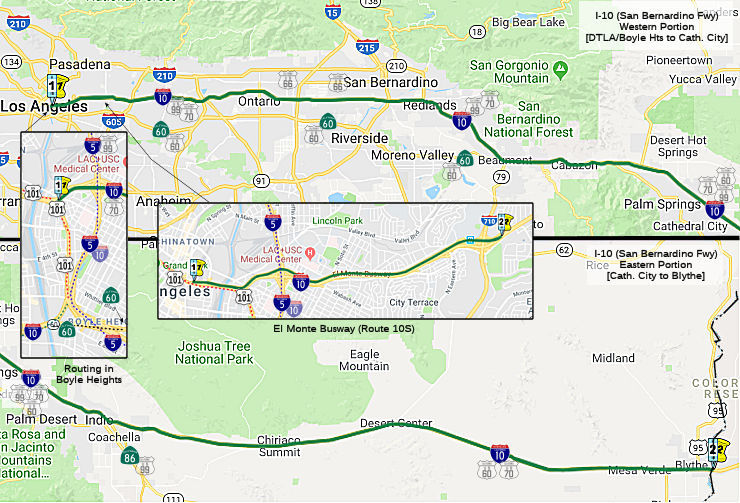 From Route 101 near Mission Road in Los Angeles to the Arizona state line at
the Colorado River via the vicinity of Monterey Park, Pomona, Colton,
Indio, and Chiriaco Summit, and via Blythe.
From Route 101 near Mission Road in Los Angeles to the Arizona state line at
the Colorado River via the vicinity of Monterey Park, Pomona, Colton,
Indio, and Chiriaco Summit, and via Blythe.
Post 1964 Signage HistoryIn 1963, this routing was defined as "Route 110 in Los Angeles to the Arizona state line at the Colorado River via the vicinity of Monterey Park, Pomona, Colton, Indio, and Shaver's Summit (later renamed Chiriaco Summit), and via Blythe, and includes that portion of the Colorado River highway bridge (near Ehrenburg, Arizona) which is within the State of California. The department may contract with the State of Arizona, for and on behalf of the State of California, for the maintenance of such bridge." Route 110 referred to the short segment of the route between US 101 and I-5, which was originally proposed as I-110.
Some history of the East LA interchange, including the connection between the two segments of I-10, may be found in the discussion of US 101.
Scott Parker on AARoads noted the following about the early days of this
end of I-10:
(Source: Sparker on AARoads, "Re: Interstate 5", 6/23/2019)
Until the widening of the San Bernardino Freeway/I-10 east of the I-5 (Golden State) interchange, the signage on WB I-10 originally only referenced West I-10 on the ramp to the SB Golden State Freeway -- no mention of SB I-5; traffic to SB I-5 (essentially a "backwards" movement regarding the trajectory of the Santa Ana Freeway) was expected to remain on the western "stub" of the San Bernardino Freeway (original I-110 and briefly BGS-signed as such from WB I-10) to the "San Bernardino Split", where it would take the single-lane flyover to the SB Santa Ana Freeway (originally I-105 but never signed -- although prominently featured on Gousha L.A. maps in the early '60's), aka US 101 at that point. That ramp, signed for SB I-5 after signage was applied to that freeway in 1961-62 and featuring substandard clearance beneath it, was dismantled at the same time of the San Bernardino Freeway upgrades; at which point the ramp carrying WB I-10 was signed as access to both I-10 and SB I-5 as it is today.
In 1968, the stub Route 105 and
Route 110 were eliminated, and the portion from Route 101 to Route 5 was
transferred from former Route 110. This changed the routing to "(b) Route 101 near Mission Road in Los Angeles to Route 5. (c) Route 5 in Los
Angeles to the Arizona state line at the Colorado River...", reflecting
the slight discontinuity at Route 5. However, it is unclear if the former
Route 110 portion was added to the Interstate system.
In 1984, the two segments were combined, and the text about Arizona was removed, giving the definition of "(b) Route 101 near Mission Road in Los Angeles to the Arizona state line at the Colorado River via the vicinity of Monterey Park, Pomona, Colton, Indio, and Chiriaco Summit and via Blythe."
Note that the El Monte Busway, a special transit (and at times, HOV+3) lane, running from Union Station in Downtown Los Angeles to just E of Route 710, is in the postmile system as Route 10S.
Near the intersection of I-10 and former Route 31, Ontario had a racetrack. Between 1971 and 1980, this track hosted Indycar/CART, NHRA, and NASCAR events; this racetrack was designed in a similar shape to the more famous Indianapolis Motor Speedway and was intended to bring a second venue of major auto racing into the Los Angeles area (the first was the now-defunct Riverside International Raceway, which is located at the I-215/Route 60 junction). This track also hosted the "Questor Grand Prix", an allstar event attempting to prove whether American formula racers were superior to those from Europe. After Ontario Motor Speedway went bankrupt in 1980, the track was demolished and the land is now owned by ChevronTexaco. It was near where Ontario Mills now stands, and might explain the car-named streets between Haven Avenue and old Route 31: Dusenberg Drive, Ferrari, Mercedes Lane, Porsche Way, and Concours, and the car named streets west of Haven Avenue: Triumph Lane, Shelby Street, Shelby Lane, Lotus Avenue, Jaguar Way.
In 1964, a 10-mile segment of US 60/I-10 east of Indio was completed to
freeway standards. In 1965, AASHO approved US 60 to be truncated from
downtown Los Angeles to US 95 in Blythe. The truncation of US 60 to
Blythe left only temporary I-10 on the Indio stub of Dillon Road. By 1967,
I-10 had a determined freeway routing that would bypass Indio and connect
with a planned freeway to Thermal. Pending construction, I-10 followed an
interim alignment through Indio from the Indio Rail Overhead along Indio
Boulevard and Dillon Road to the Indio-Cutoff. By 1975, I-10 was completed
through Indio and the segment of Dillon Road in the State Highway System
was relinquished.
(Source: Gribblenation Blog (Tom Fearer), "Dillon Road", 9/15/2023)
By 1967, I-10 had a determined freeway routing that bypassed Indio and
connected with a planned freeway to Thermal. I-10 followed an
interim alignment through Indio from the Indio Rail Overhead along Indio
Boulevard and Dillon Road to the Indio-Cutoff. It then followed a
portion of the Indio-Cutoff to the vicinity of Box Canyon Road. It
had a determined realignment in Chuckwalla Valley in addition to
Blythe. The interim alignment of I-10 east of Intake Boulevard in
Blythe was concurrent with US 60 and US 95 to the Colorado River
Bridge. By 1969, I-10 was upgraded to freeway standards from Box
Canyon Road east through Chuckwalla Valley. The new alignment of
I-10 through Chuckwalla Valley bypassed former US 60/US 70 along
Chuckwalla Valley Road and Ragsdale Road in Desert Center. By 1970,
I-10 was constructed to freeway standards east of Chuckwalla Valley to the
outskirts of Blythe. By 1975, the bypass of Blythe was constructed.
(Source: Gribblenation Blog (Tom Fearer), "Interstate 10 in the Sonoran Desert between the Colorado River and Coachella Valley", 10/14/2023)
Pre 1964 Signage History This segment was made up of four distinct parts:
In Blythe, this was Hobsonway, and used a different bridge to cross the Colorado. The current bridge was built in 1960, with improvements in 1974. No remnants of the original bridge remain.
The Ramona Expressway portion of I-10 started its development shortly
after the US Highway system was adopted in 1926. At this time, California
began development of US 99. In Monterey Park, Garvey Avenue was designated
as part of the link of US 99. However, westerly of Atlantic Boulevard, the
roadway ended. The six-mile gap would be filled by a new roadway that
would connect Garvey Avenue near Atlantic Boulevard with Aliso Street at
Mission Road to be named Ramona Boulevard. Ramona Boulevard was along
terrain that was suitable for grade separations, with the Pacific Electric
Railroad tracks to the north and a hillside to the south. In order to
accommodate the new highway, six bridges that already spanned the tracks
were extended or reconstructed and two new grade separations were
constructed near Monterey Pass Road. Near the west end of the project, the
Macy Street (now Cesar E. Chavez Avenue) bridge, which had been built in
1910, provided another grade separation over the tracks and could
accommodate a roadway without reconstruction. Thus, there were nine
bridges in all with no at-grade crossings and virtually no local property
access. It was opened to traffic on April 20, 1935 and was called an
“airline” route by the State because motorists could
“fly” without intersectional conflict at 50 miles per hour. In
1944, Aliso Street, the westerly extension of Ramona Boulevard was widened
and reconstructed. This project, which was undertaken by the City,
included a grade separation at Mission Road. In coordination with this
project, the State widened Ramona Boulevard easterly to the East City
Limit and constructed a four-foot wide median. Upon the completion of
these projects, Ramona Boulevard was renamed Ramona Parkway. In 1954,
shortly after Ramona Parkway was extended easterly of the City, it was
renamed the San Bernardino Freeway. In 1970, most of the 1935 and 1944
improvements were demolished to make way for the San Bernardino Freeway
and Express Busway.
(The historical information above on the Ramona
Expressway was derived from "Transportation Topics and Tales: Milestones
in Transportation History in Southern California" by John E. Fisher,
P.E. PTOE, available at http://ladot.lacity.org/pdf/PDF100.pdf)
In October 2019, more information was published on the Ramona Expressway.
Leaving downtown LA in City Terrace, it was called Ramona Boulevard before
it merged with Garvey Avenue. East of Monterey Park, the route was a
straight line — sometimes called an “air line” —
to the San Jose Hills and Pomona’s Holt Avenue. A good share of it
today lies under I-10. The main remnant of the route is on Garvey between
I-710 and where it merges into I-10 on the east end of El Monte. A few
links of frontage road along I-10 in Covina and West Covina are still
called Garvey Avenue. A small portion of Holt Avenue exists in Covina,
though a connection with Pomona’s Holt has since been sliced and
diced by freeway expansion over Kellogg Hill. The route itself was adopted
by the state in 1931. The first stretch of the new highway construction
for the project was from Pomona through W.J. Kellogg’s ranch (the
future Cal Poly Pomona) and over the San Jose Hills to Barranca Street in
West Covina. News accounts said the entire paved route would finally be
ready for travel on April 4, 1935, though some portions of it had opened
earlier. However, the Pomona Progress-Bulletin said on April 8 that heavy
rains delayed completing the work, and the full route didn’t open
for another few days. The article also said that the state had approved a
$12,000 contract to plant 25,000 ground-cover plants as well as two dozen
types of trees and shrubs along the highway. The new Pomona-LA road helped
spawn additional construction in the Inland Empire. Improvement programs
were begun on segments of Holt in Pomona and A Street in Ontario and
farther east when the route became Valley Boulevard in Fontana.
(Source: Daily Bulletin, 10/7/2019)
On July 15, 1952, the California Highway Commission adopted I-10 as a freeway. I-10 became part of the Freeway & Expressway System in 1959 and is also part of the Interstate Highway System. I-10 is included in the State Interregional Road Systems and is further classified as a “High Emphasis” and “Gateway” route. The entire length of I-10 is included in the National Highway System, the Department of Defense Priority Network, and the Strategic Highway Corridor Network. The 1990 Federal Surface Transportation Assistance Act (STAA) identifies I-10 as a “National Network” route for STAA trucks. The Federal Functional Classifications for I-10 are Rural Principal Arterial and extension of a Rural Principal Arterial into an urban area.
The history of the East LA Interchange, where US 101, I-10, I-5, and Route 60 come together, is discussed with US 101.
 Planning for the segment in Pomona began in the late 1940s. In September 1947, the Pomona City
Council took action on the freeway agreement with the state. The agreement
covered closing numerous city streets, carrying of three principal N-S
routes across the freeway, and opening and relocation of other city
streets. The streets that would remain open and cross the freeway were
White, Garey, and Towne. There would also be a crossing in S. Claremont at
Alexander Avenue. Eventually, there would also be crossings at Dudley,
Fairplex, Orange Grove, and San Antonio. Although the map shows a crossing
at Hamilton, that appears to have never been built.
Planning for the segment in Pomona began in the late 1940s. In September 1947, the Pomona City
Council took action on the freeway agreement with the state. The agreement
covered closing numerous city streets, carrying of three principal N-S
routes across the freeway, and opening and relocation of other city
streets. The streets that would remain open and cross the freeway were
White, Garey, and Towne. There would also be a crossing in S. Claremont at
Alexander Avenue. Eventually, there would also be crossings at Dudley,
Fairplex, Orange Grove, and San Antonio. Although the map shows a crossing
at Hamilton, that appears to have never been built.
(Source: Pomona Progress Bulletin, 9/30/1947)
According to the Inland Valley Daily Bulletin, the first segment of the "Ramona Freeway" opened on Nov. 16, 1954, with a segment running 13.4 miles from Kellogg Hill in Pomona to Archibald Avenue in Ontario. The freeway to the west between El Monte and Covina was still being built, and work hadn't even started east of Ontario. The routing was contentious. Pomona fought the route for five years, wanting it to go north around the San Jose Hills in the vicinity of Arrow Highway. Ontario and Upland also battled over their part of the highway, finally agreeing on a route that tight-roped their joint boundary. Farther west, El Monte was involved in a bitter dispute over the route that cut the city in half. As for the naming, "San Bernardino Freeway" was bestowed on November 24, 1954, just eight days after the opening ceremonies. Originally called the Ramona Freeway, Pomona interests had pushed for the route to be named for their city, which it bisected. Instead, the State Highway Commission announced the route would be known as the San Bernardino Freeway, even though the completed freeway wouldn't even go to downtown San Bernardino, unless you made a left turn on US 395 (now Route 15) just east of Colton. They suggested that the future "foothills" route (I-210 Freeway) would be better named for San Bernardino.
 In 1957, there were five proposed freeway routings for the segment from the
junction with LRN 31 (Pre-1965 US 395/US 91 ⇒ Post-1964 I-215) near
E Street W of Loma Linda and Live Oak Canyon near Yucaipa. On the map
shown, circles indicate traffic interchanges, and squares indicate
bridges. The map has been augmented to highlight the state highway route
existing at the time, as well as the final route selected. Note that if
the San Timoteo route was selected, it would join US 60 (Jack Rabbit
Trail) at a point 4 mi W of Beaumont. The San Timoteo route and the South
Redlands route would follow the same line from E St to just E of Bryn
Mawr. Although the Live Oak Canyon connection was initially supported by
the City of Redlands, the state later downgraded that proposal, noting
that it would cost more to build than the amount of dollar benefits it
would return to motorists over a 20 year period. They rated the San
Timoteo route, with no Live Oak leg, as the better route.
In 1957, there were five proposed freeway routings for the segment from the
junction with LRN 31 (Pre-1965 US 395/US 91 ⇒ Post-1964 I-215) near
E Street W of Loma Linda and Live Oak Canyon near Yucaipa. On the map
shown, circles indicate traffic interchanges, and squares indicate
bridges. The map has been augmented to highlight the state highway route
existing at the time, as well as the final route selected. Note that if
the San Timoteo route was selected, it would join US 60 (Jack Rabbit
Trail) at a point 4 mi W of Beaumont. The San Timoteo route and the South
Redlands route would follow the same line from E St to just E of Bryn
Mawr. Although the Live Oak Canyon connection was initially supported by
the City of Redlands, the state later downgraded that proposal, noting
that it would cost more to build than the amount of dollar benefits it
would return to motorists over a 20 year period. They rated the San
Timoteo route, with no Live Oak leg, as the better route.
(Source: Redlands Daily Facts, 1/30/1957)
Later in 1957, it was reported that the Central Redlands Route was
adopted.Plans called for construction of a 4-lane freeway, with provisions
for 6-lanes. Initial cost would be $11.42 million.
(Source: Unspecified Newspaper, 1957, via Joel
Windmiller, 1/27/2023)
The portion of the route E of San Gorgonio dates back to the Bradshaw
Trail. The Bradshaw Trail was a wagon road through the Sonoran Desert east
to the Colorado River. During the California Gold Rush the Bradshaw Trail
was plotted through the Sonoran Desert by William D. Bradshaw. The
Bradshaw Trail despite it's elongated path essentially was the forerunner of what would become modern I-10
from Palm Springs to the City of Blythe. During the 1916 Second State
Highway Bond Act LRN 26 was added to the State Highway System as a route
from San Bernardino southeast to El Centro. LRN 26 was essentially a
forerunner of what would become the earliest alignments of US 99.
(Source: Gribblenation Blog "Califoooornia! (Interstate 10 west from CA 86 through Coachella Valley and San Gorgonio Pass to CA 60 in the Moreno Valley Badlands)")
From a point W of Palm Ave to Indio, the former routing of US 60/US 70/US 99 was along Varner Road. This met Jefferson St (now Business Route 10) in Indio.
By 1924, the stretch beween Mecca and the Arizona Border was part of the
Atlantic and Pacific Highway. This would become LRN 64. The general
routing of LRN 64 was different from the Bradshaw Trail as it followed Box
Canyon, Chiriaco Summit and Chuckwalla Valley. 1924 saw the start of work
to modernize/grade LRN 64 (the Mecca-Blythe Highway. Improvements
were in the segment from Shavers Well in Box Canyon and extending east to
Blythe.
(Source: Gribblenation Blog "Califoooornia! (Interstate 10 west from CA 86 through Coachella Valley and San Gorgonio Pass to CA 60 in the Moreno Valley Badlands)"; Gribblenation Blog (Tom Fearer), "Interstate 10 in the Sonoran Desert between the Colorado River and Coachella Valley", 10/14/2023)
As originally envisioned in the early drafts of US Route System. what
became US 66 in California was intended to be US 60. The designation
of the Chicago-Los Angeles corridor was intended to carry a X0 route
number given it was to denote a major east/west US Route. Ultimately
the State of Kentucky petitioned to have a X0 US Route, and the
Chicago-Los Angeles corridor became US 66 in the finalized US Route System
created by the American Association of State Highway Officials (AASHO)
during November 1926. The X0 route in Kentucky, US 60, would rapidly
be extended after the US Route System was created and would come into play
in California during the early 1930s. A letter from the AASHO
Executive Secretary to the California State Highway Engineer dated Marth
30, 1931, noted US 60 had been tentatively approved to be extended to
California during the AASHO Executive Committee on May 26, 1930. The
approval of US 60 being extended to California carried the stipulation
that the Colorado River Bridge in Blythe be purchased by the California
Division of Highways and Arizona State Road Department. The letter
noted California and Arizona had taken steps through their respective
legislatures to purchase the Colorado River Bridge and the terminus of US 60 would be at an undisclosed location in Los Angeles.
(Source: Gribblenation Blog (Tom Fearer), "Interstate 10 in the Sonoran Desert between the Colorado River and Coachella Valley", 10/14/2023)
The California State Highway Engineer submitted a recommended routing of
US 60 to the AASHO Executive Secretary on September 8, 1931. The
route description of US 60 show as ending in Los Angeles by way of Pomona
at an undisclosed terminus. The routing of US 60 defined it as
entering Coachella Valley via LRN 64 through Box Canyon to Mecca towards
Coachella. From Coachella US 60 joined US 99/LRN 26 passing through
Coachella Valley towards San Gorgonio Pass. A September 1934
exchange of letters between the California State Highway Engineer and
AASHO acknowledged US 70 had been extended into California with an
endpoint following US 60 into downtown Los Angeles. The routing
definition of US 70 indicated it would multiplex US 99/US 60 east from
downtown Los Angeles to Pomona and onwards multiplexed with US 60 east to
Beaumont and US 99/US 60 through San Gorgonio Pass and Coachella Valley to
LRN 64 near Coachella. From Coachella US 70 followed US 60 via LRN 64 to the Arizona State Line.
(Source: Gribblenation Blog (Tom Fearer), "Interstate 10 in the Sonoran Desert between the Colorado River and Coachella Valley", 10/14/2023)
The 1934 State Highway Map shows a fully graded LRN 64 carrying US 60.
The 1935 California Division of Highways Map of Riverside County shows the
entire routing of LRN 64 in far more detail. LRN 64/US 60/US 70 originally
diverged significantly from I-10 using alignments on Chuckwalla Valley
Road and Box Canyon Road. A September 1934 Department of Public Works
Guide describes the construction of what was known as the "Indio Cut-Off"
route of US 60 bypassing Box Canyon Road. Chiraco Summit at the time was
referred to has "Shaver's Summit" and the Guide states that Box Canyon
Road was oiled in 1933. The Indio Cut-Off is described as having a 6.3%
grade and an anticipated opening of July 1935. By late 1935 the modern
grade used by I-10 descending westward from Chiriaco Summit into Coachella
Valley in proximity to Coachella was completed. US 60/US 70 were moved to
the new grade by 1936. By 1940 US 95 was routed into California via what
was Route 195. After US 95 was extended to California, a second Route 195
was created along LRN 64 on Box Canyon Road. LRN 64 was actually a split
route carrying US 60/US 70 on the north segment and Route 195 on Box
Canyon Road, according to the 1940 State Highway Map. By the 1966 State
Highway Map edition the planned bypass of Chuckwalla Valley Road appears.
By the 1967 State Highway Map I-10 appears co-signed with US 60 from
Coachella to Chiriaco Summit. By 1969, I-10 bypassed Chuckwalla Valley and
was nearly completed through the Sonoran Desert. West of Chuckwalla Valley
Road the former routing of US 60/US 70 in Desert Center was on Ragsdale
Road just north of I-10.
(Source: Gribblenation Blog Old US Route 60/70 through Hell (Chuckwall Valley Road and Ragsdale Road), Califoooornia!(Interstate 10
west from CA 86 through Coachella Valley and San Gorgonio Pass to
CA 60 in the Moreno Valley Badlands))
Modern Dillon Road between Grapefruit Boulevard and I-10 was once part of
the Indio-Cutoff alignment of US 60 and US 70. In 1934, construction
began on the Indio-Cutoff Spur of LRN 64. The Indio-Cutoff was to
serve as a new alignment of US 60/US 70 that would enter Coachella Valley
via Dillon Road and would provide a bypass to the hazards of Box Canyon.
The cutoff opened in 1935, and US 60/US 70 was realigned onto the new spur
of LRN 64. This was five months ahead of schedule; and the new cutoff was
9 miles shorter than the original alignment of US 60/US 70 through Box
Canyon. Despite Box Canyon no longer being part of US 60/US 70, it would
remain under State maintenance and become part of the second Route 195. The eastern end of the Indio-Cutoff near Indio incorporated
Dillon Road into its alignment.
(Source: Gribblenation Blog (Tom Fearer), "Dillon Road", 9/15/2023)
In 1935, the alignment of US 60/US 70/LRN 64 east from Mecca to the
Arizona state line split from US 99 in Coachella. US 99 split via
what is Cesar Chavez Street on LRN 26 towards El Centro, whereas US 60/US 70 followed Grapefruit Boulevard on LRN 64 towards Mecca and Box
Canyon. From Box Canyon, US 60/US 70/LRN 64 continued east over
Chiriaco Summit towards Chuckwalla Valley. US 60/US 70/LRN 64
eastbound passed through Chuckwalla Valley along what is now Chuckwalla
Valley Road towards Blythe. Within Blythe. US 60/US 70/LRN 64
followed Hobsonway to the Colorado River Bridge at the Arizona state
line.
(Source: Gribblenation Blog (Tom Fearer), "Interstate 10 in the Sonoran Desert between the Colorado River and Coachella Valley", 10/14/2023)
The highway from Blythe to Needles was originally Sign Route 195/LRN 146.
The AASHO Executive Secretary advised the Highway Engineers of California,
Nevada, Oregon and Idaho in a letter dated July 7, 1939, that the AASHO
Executive Committee approved the extension of US 95 to Blythe,
California. US 95 absorbed the existing routing of Sign Route 195/LRN 146 from the Nevada State Line south to US 60/US 70/LRN 64 at
Hobson Way in Blythe. Upon the extension of US 95 into California
the original Sign Route 195 was deleted. The Sign Route 195 number
was reassigned to the former routing of US 60/US 70 via the spur of LRN 64
in Box Canyon.
(Source: Gribblenation Blog (Tom Fearer), "Interstate 10 in the Sonoran Desert between the Colorado River and Coachella Valley", 10/14/2023)
In 1958, US 60/US 70/LRN 64 from Indio-Cactus City was under study to
expand to freeway standards. US 60/US 70/LRN 64 from Cactus City
east to the Arizona State Line had a freeway alignment adopted by the
California Highway Commission. US 70 was truncated from Los Angeles
to US 95 in Blythe by the American Association of State Highway Officials
on August 26, 1963. The truncation of US 70 left only US 60 and
temporary I-10 as the only signed routes using the Indio stub of Dillon
Road along the Indio-Cutoff. LRN 26 would be dropped along with all
the Legislative Route Numbers as part of the 1964 State Highway
Renumbering.
(Source: Gribblenation Blog (Tom Fearer), "Dillon Road", 9/15/2023)
In Blythe, the first bridge to cross the Colorado replaced an existing cable ferry, established in 1870 between Ehrenberg AZ and Blythe CA. The new bridge, opened in 1928, was a toll bridge constructed by Riverside County, and was not part of the state highway system (although it was an extension of LRN 64). It had five steel truss spans each 190' long, for a total length of 950'. The roadbed was 20' wide, and it was 30' above the water. In 1931, the state purchased the toll bridge.
The truncation of US 99 from Calexico to the junction of the Golden State
Freeway and San Bernardino Freeway in Los Angeles was approved by the
AASHO Executive Committee on June 19, 1963. US 70 was truncated from
Los Angeles to US 95 in Blythe by AASHO on August 26, 1963. LRN 64
was dropped as part of the 1964 State Highway Renumbering. The AASHO
Executive Committee approved US 60 to be truncated from downtown Los
Angeles to US 95 in Blythe on October 2, 1965. On June 24, 1969, AASHO
approved an Arizona Highway Department request to truncate US 70 from the
California State Line to Globe, Arizona. US Route 60 was officially
deleted in California by AASHTO during their November 1982 meeting, with a
new ending at I-10 near Brenda, Arizona.
(Source: Gribblenation Blog (Tom Fearer), "Interstate 10 in the Sonoran Desert between the Colorado River and Coachella Valley", 10/14/2023)
The February/March 1928 California Highways & Public Works featured
the opening of the Colorado River Bridge (Blythe-Ehrenburg Bridge) at the
Arizona state line east of Blythe. The Colorado River Bridge opened
as a Riverside County owned tolled crossing which replaced the existing
ferry to Ehrenburg, Arizona.
(Source: Gribblenation Blog (Tom Fearer), "Interstate 10 in the Sonoran Desert between the Colorado River and Coachella Valley", 10/14/2023)
In 1961, the new Colorado River Bridge carrying US 60/US 70/US 95/I-10
into Arizona east of Blythe was completed. Construction costs for
the new Colorado River Bridge were shared by the states of California and
Arizona. The new span replaced the earlier 1928 structure.
(Source: Gribblenation Blog (Tom Fearer), "Interstate 10 in the Sonoran Desert between the Colorado River and Coachella Valley", 10/14/2023)
StatusNote: See the HOV discussion below for the details on HOV/HOT lane additions on this segment of this route. This includes the El Monte Busway.
Downtown Los Angeles (I-5) (~ 010 LA 18.433) to El Monte (I-605) (~ 010 LA 31.078)
The SAFETEA-LU act, enacted in August 2005 as the reauthorization of TEA-21, provided the following expenditures on or near this route:
I-10/I-605 Interchange
According to an article in the San Gabriel Tribune, the I-10/I-605 interchange (~ 010 LA 31.078) was designed in 1964 and was supposed to accommodate traffic until 1984. No major changes have been undertaken there since it was built. An average of 438,000 cars use the interchange each day, making the intersection the 19th busiest in the state. According to a 1999 study by the South Coast Air Quality Management District, the area directly around the interchange has one of the highest air-pollution- related cancer risk factors in the San Gabriel Valley. One of the main problems with the intersection is what engineers call "the weave,", where vehicles transferring from the I-10 west to the I-605 south have to weave across cars getting on the I-605 south from the I-10 east. Cars from both directions have only about 150 feet to change places with each other. Additionally, drivers who want to transfer from the southbound I-605 to the eastbound I-10 east have to take a left turn when leaving the I-605. According to Caltrans, the prospects for improvements are bleak. Caltrans is considering building a flyover from the I-605 south to the I-10 east, which would eliminate the weaving-in section. The current budget crisis rules out state funding for the immediate future, and it was not appoved for funding in the 2007 CMIA allocations.
2007 CMIA. A number of projects on I-10 in Los Angeles County were submitted to the Corridor Mobility Improvement Account for funding. These projects included the I-10/I-605 transition connector ($70.5 million) (~ 010 LA 31.078). None were recommended for funding.
In March 2016, the Los Angeles MTA presented its full
proposal for what transit lines could be built -- and when -- if Los
Angeles County voters approve a half-cent sales tax increase in November
2016. This proposal included funding for the I-605/I-10 Interchange
project that will improve interchanges from Eastbound I-10 to Southbound
I-605, Westbound I-10 to Southbound I-605, Northbound I-605 to Eastbound
I-10, and Northbound I-605 to Westbound I-10.
(Source: Los Angeles Times 3/18/2016; Metro Board Report 3/24/2016)
Note: See the HOV discussion below for the details on HOV/HOT lane additions on this segment of this route.
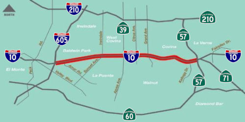 In August 2016, it was reported that the new soundwalls
in West Covina weren't making everyone happy. For almost 60 years, the
stretch of freeway between the border with Baldwin Park and Route 57 atop
Kellogg Hill has shaped the history of the largest city in the east San
Gabriel Valley. It’s not just the automobiles that travel the
freeway,but the swatch of retail stores lining both sides of the freeway.
With an addition of 18 miles of carpool lanes and more importantly, stone
soundwalls towering 12 feet to 16 feet above the small, ranch-style homes
nearby, the freeway’s look is changing, along with the city of
111,000 people. In particular, although the walls keep the car noise in,
they also keep views of kitschy landmarks and the San Gabriel Mountains
hidden. The view of restaurant signs, rolling hills, even mid-century
modern apartment buildings painted baby blue or aqua are at times shrouded
by the soundwalls. Some say the familiar sites of hillside graves along
the south side of the freeway, part of Forest Lawn Cemetery, will be a
lost sight from the vantage point of eastbound freeway riders. The walls
block the resident's view of the mountains, and most importantly, the
freeway. Many who drive down Lark Ellen or Hollenbeck would eye the
traffic on the 10 Freeway and if it was heavy, detour to the Route 60
Freeway or surface streets. The soundwalls block their view. Caltrans is
required to reduce traffic noise by 5 decibels, a change that is
considered readily noticeable. Although the walls reduce the noise near
the freeway, some residents who live farther away from the freeway said
the noise has traveled higher, into the hillside communities. Stores,
restaurants and auto dealerships also fought not to have high soundwalls
blocking views from the freeway. Eastland Center, home to Walmart, Target,
Ross, Dick’s Sporting Goods and other stores and restaurants worked
a deal with Caltrans, as did Plaza West Covina, the indoor shopping mall
on the south side of the 10, formerly called Westfield West Covina until
it was sold to Starwood Capital Group in 2013. These centers have only
6-foot high walls with 2-feet of strong, mesh fencing on top, as do the
car dealerships, making them and their signage easily visible from freeway
level. Essentially, the soundwalls, besides giving motorists a
claustrophobic, underground feel, may hurt the economics of Baldwin Park
and West Covina, cities reliant on sales tax dollars. Combined with an
emphasis on residential, the post-2021 freeway may actually lower tax
revenues. The current walls are part of the second phase of the project.
The project is divided into three segments: from I-605 to Puente Avenue in
Baldwin Park; from Puente Avenue to Citrus Street in West Covina; from
Citrus Street to Route 57. Caltrans has completed the first segment and is
working on segments two and three. The second segment will be completed in
2019 and the third and final segment may be finished in summer of 2021.
Once done, the gap in the carpool lanes will be closed, creating 40 miles
of High Occupancy Vehicle (carpool) lanes in each direction from downtown
Los Angeles to I-15 Freeway in San Bernardino County. The added carpool
lane in each direction is supposed to ease traffic. Gridlock on this
stretch of the 10 is what Caltrans calls “exceeding capacity,”
and runs every weekday from 6 a.m. to 9 a.m. westbound and from 3 p.m. to
7 p.m. eastbound.
In August 2016, it was reported that the new soundwalls
in West Covina weren't making everyone happy. For almost 60 years, the
stretch of freeway between the border with Baldwin Park and Route 57 atop
Kellogg Hill has shaped the history of the largest city in the east San
Gabriel Valley. It’s not just the automobiles that travel the
freeway,but the swatch of retail stores lining both sides of the freeway.
With an addition of 18 miles of carpool lanes and more importantly, stone
soundwalls towering 12 feet to 16 feet above the small, ranch-style homes
nearby, the freeway’s look is changing, along with the city of
111,000 people. In particular, although the walls keep the car noise in,
they also keep views of kitschy landmarks and the San Gabriel Mountains
hidden. The view of restaurant signs, rolling hills, even mid-century
modern apartment buildings painted baby blue or aqua are at times shrouded
by the soundwalls. Some say the familiar sites of hillside graves along
the south side of the freeway, part of Forest Lawn Cemetery, will be a
lost sight from the vantage point of eastbound freeway riders. The walls
block the resident's view of the mountains, and most importantly, the
freeway. Many who drive down Lark Ellen or Hollenbeck would eye the
traffic on the 10 Freeway and if it was heavy, detour to the Route 60
Freeway or surface streets. The soundwalls block their view. Caltrans is
required to reduce traffic noise by 5 decibels, a change that is
considered readily noticeable. Although the walls reduce the noise near
the freeway, some residents who live farther away from the freeway said
the noise has traveled higher, into the hillside communities. Stores,
restaurants and auto dealerships also fought not to have high soundwalls
blocking views from the freeway. Eastland Center, home to Walmart, Target,
Ross, Dick’s Sporting Goods and other stores and restaurants worked
a deal with Caltrans, as did Plaza West Covina, the indoor shopping mall
on the south side of the 10, formerly called Westfield West Covina until
it was sold to Starwood Capital Group in 2013. These centers have only
6-foot high walls with 2-feet of strong, mesh fencing on top, as do the
car dealerships, making them and their signage easily visible from freeway
level. Essentially, the soundwalls, besides giving motorists a
claustrophobic, underground feel, may hurt the economics of Baldwin Park
and West Covina, cities reliant on sales tax dollars. Combined with an
emphasis on residential, the post-2021 freeway may actually lower tax
revenues. The current walls are part of the second phase of the project.
The project is divided into three segments: from I-605 to Puente Avenue in
Baldwin Park; from Puente Avenue to Citrus Street in West Covina; from
Citrus Street to Route 57. Caltrans has completed the first segment and is
working on segments two and three. The second segment will be completed in
2019 and the third and final segment may be finished in summer of 2021.
Once done, the gap in the carpool lanes will be closed, creating 40 miles
of High Occupancy Vehicle (carpool) lanes in each direction from downtown
Los Angeles to I-15 Freeway in San Bernardino County. The added carpool
lane in each direction is supposed to ease traffic. Gridlock on this
stretch of the 10 is what Caltrans calls “exceeding capacity,”
and runs every weekday from 6 a.m. to 9 a.m. westbound and from 3 p.m. to
7 p.m. eastbound.
(Source: SGV Tribune 8/14/2016)
In August 2016, the CTC authorized relinquishment of right of way in the city of Baldwin Park (City) along Route 10 on Francisquito Avenue and Garvey Avenue (07-LA-10-PM 32.7), consisting of collateral facilities. The City, by freeway agreement dated April 10, 1958, agreed to accept title upon relinquishment by the State, and by letter dated June 5, 2016, agreed to waive the 90-day notice requirement and accept the relinquishment.
Pomona (Route 57/Route 71) to Ontario (I-15)
The SAFETEA-LU act, enacted in August 2005 as the reauthorization of TEA-21, provided the following expenditures on or near this route:
Ontario (I-15) to Colton (I-215)
Cherry / Citrus / Cedar Improvements in Fontana
In 2007, the CTC recommended using the Corridor Mobility Improvement Account (CMIA) to fund widening of the ramps and addition of aux. lanes at Cherry (~ SBD 13.175), Citrus (SBD 15.221) & Cedar (SBD R18.486) ($30,325K requested, $19,233 recommended) and a WB mixed flow lane from Live Oak Cyn to Ford St ($38,186K requested; $26,500K recommended).
In March 2009, the CTC approved for future consideration of funding a project in San Bernardino County is to reconstruct the Cherry Avenue Interchange (~ SBD 13.175), widen the overcrossing, and construct roadway improvements in the city of Fontana. The project is programmed in the Trade Corridors Improvement Fund (TCIF) and the 2008 State Transportation Improvement Program, and includes local funds. Total estimated cost is $76,900,000. Construction is estimated to begin in Fiscal Year 2011-12.
In March 2009, the CTC approved for future consideration of funding a project in San Bernardino County is to reconstruct the Citrus Avenue Interchange (SBD 15.221), widen the overcrossing, and construct roadway improvements in the city of Fontana. The project is programmed in the Trade Corridors Improvement Fund (TCIF) and the 2008 State Transportation Improvement Program, and includes local funds. Total estimated cost is $54,458,000. Construction is estimated to begin in Fiscal Year 2010-11.
The SAFETEA-LU act, enacted in August 2005 as the reauthorization of TEA-21, provided the following expenditures on or near this route:
In October 2013, the CTC considered for future approval of funding a project in San Bernardino County that will widen and improve the existing Cedar Avenue interchange on I-10 at Cedar Avenue (~ SBD R18.428) in the community of Bloomington. The project is fully funded with federal and local dollars. The total estimated cost is $62,730,000 for capital and support. Construction is estimated to begin in Fiscal Year 2014-15.
Riverside Avenue Interchange
The SAFETEA-LU act, enacted in August 2005 as the reauthorization of TEA-21, provided the following expenditures on or near this route:
 In April 2009, the CTC approved for future consideration of funding a project to reconstruct the existing
Riverside Avenue interchange (~010 SBD 19.977) at Route 10 to improve
interchange and mainline operation and safety. The project is programmed
in the Trade Corridors Improvement Fund (TCIF) and the 2008 State
Transportation Improvement Program, and includes federal and local funds.
Total estimated project cost is $34,000,000, capital and support.
Construction is estimated to begin in Fiscal Year 2008-09. The scope as
described for the preferred alternative is consistent with the project
scope set forth in the approved project baseline agreement.
In April 2009, the CTC approved for future consideration of funding a project to reconstruct the existing
Riverside Avenue interchange (~010 SBD 19.977) at Route 10 to improve
interchange and mainline operation and safety. The project is programmed
in the Trade Corridors Improvement Fund (TCIF) and the 2008 State
Transportation Improvement Program, and includes federal and local funds.
Total estimated project cost is $34,000,000, capital and support.
Construction is estimated to begin in Fiscal Year 2008-09. The scope as
described for the preferred alternative is consistent with the project
scope set forth in the approved project baseline agreement.
In March 2011, it was reported that crews are scheduled
to demolish the Riverside Avenue bridge in early May 2011. Once the
five-lane bridge comes down, the contractor has a deadline to replace it
with a nine-lane overpass, part of a plan to increase traffic flow in the
area. The construction agreement includes a requirement that the
contractor reopen the new bridge seven months after it closes the old one.
A penalty will be assessed for opening late, and a bonus will be paid if
the overpass opens earlier than expected. The larger bridge will give
drivers two turn lanes in each direction from which to turn onto I-10.
There will be three northbound lanes and two southbound lanes for through
traffic. Entrance and exit ramps at Riverside Avenue and I-10 are also
being widened, to accommodate more vehicles. Most of the money for the $32
million project is coming from the city's redevelopment agency and
California's Prop. 1B transportation bond program.
(Source: Press Enterprise, 3/20/11)
In May 2015, the CTC approved a request to amend the TCIF Program by including the I-10 Pepper Avenue Interchange Project (~ 010 SBD 20.971) as Project 109 in the Los Angeles/Inland Corridor element of the TCIF Program and program $1.158 million of TCIF funds to the project. The proposed project would widen Pepper Avenue from three lanes to five lanes, lengthen turn lanes and improve intersection geometric design, replace the existing I-10 Pepper Avenue Bridge, correct features to meet Americans with Disabilities Act standards, provide sidewalks, shoulders and other pedestrian features. The proposed improvements will address increases in vehicular and truck traffic as a result of growth and development in the area. Since award savings in TCIF funds were realized in the Los Angeles/Inland Corridor, the SCCG and SANBAG propose to place TCIF savings on this project (see attached letters). The total cost of the project is estimated at $10.111 million.
In May 2016, the CTC approved $1,000,000 for a minor SHOPP project in Colton, at the Rancho Avenue Overcrossing on I-10 (~ 010 SBD R21.962), widen ramp from one lane to two lanes at the eastbound on-ramp. Outcome/Output: Widen ramp to improve the State Highway System (SHS).
Colton (I-215) to Eastern Edge of Redlands (just E of Route 210)
The SAFETEA-LU act, enacted in August 2005 as the reauthorization of TEA-21, provided the following expenditures on or near this route:
Tippecanoe Avenue Interchange Improvements
![[Tippicanoe Interchange]](maps/010-tippicanoe.jpg) In May 2011, the CTC approved for future consideration of funding a project
that will reconstruct the I-10/Tippecanoe Avenue Interchange (~ 010 SBD
26.295), construct auxiliary lanes on Route 10, and improve local traffic
operations. The project is programmed in the 2010 State Transportation
Improvement Program and includes federal demonstration and local funds.
The total estimated cost is $80,021,000 for capital and support.
Construction is estimated to begin in Fiscal Year 2011-12. The scope as
described for the preferred alternative is consistent with the project
scope programmed by the Commission in the 2010 State Transportation
Improvement Program. A copy of the MND has been provided to Commission
staff. The project will mitigate potential impacts to paleontological
resources and community character and cohesion to a less than significant
level. Potential impacts to paleontological resources in the project area
will be mitigated by preparing and implementing a Paleontological
Mitigation Plan.
In May 2011, the CTC approved for future consideration of funding a project
that will reconstruct the I-10/Tippecanoe Avenue Interchange (~ 010 SBD
26.295), construct auxiliary lanes on Route 10, and improve local traffic
operations. The project is programmed in the 2010 State Transportation
Improvement Program and includes federal demonstration and local funds.
The total estimated cost is $80,021,000 for capital and support.
Construction is estimated to begin in Fiscal Year 2011-12. The scope as
described for the preferred alternative is consistent with the project
scope programmed by the Commission in the 2010 State Transportation
Improvement Program. A copy of the MND has been provided to Commission
staff. The project will mitigate potential impacts to paleontological
resources and community character and cohesion to a less than significant
level. Potential impacts to paleontological resources in the project area
will be mitigated by preparing and implementing a Paleontological
Mitigation Plan.
In April 2012, the CTC amended the CMIA funding: On I-10, $10,000,000 to the San Bernardino Association of Governments for 08-SBd-10 25.3/26.3 I-10/Tippecanoe Interchange Improvements-Phase 1. In the cities of Loma Linda and San Bernardino, from 1 mile west of Tippecanoe Avenue to Tippecanoe Avenue. Construct eastbound auxiliary lane, eastbound off ramp, retaining walls, reinforced concrete box culvert, and widen San Timoteo Bridge.
In December 2012, the CTC amended the CMIA baseline agreement for the I-10 Tippecanoe Avenue Interchange Improvements (Phase 1) project (PPNO 0154F) to update the project funding plan to include additional local funds. The construction contract was advertised in June 2012. When bids were opened, the lowest bid came slightly over the Engineer’s Estimate. The contract was awarded in July 2012 with a total project allotment of $13,787,000, an increase of $787,000 over the approved budget. This shortfall was covered with a combination of local and federal funds. The revised funding plan reflects the addition of these funds.
In April 2012, it was reported that construction is
planned for I-10 at Tippecanoe Avenue and Anderson Street to improve
traffic flow to Loma Linda. Specifically, the interchange is being
reworked to improve access to key destinations, including Loma Linda
University Medical Center, the San Bernardino International Airport and
the Jerry Pettis Memorial Veterans Hospital. The Loma Linda Academy and
retail centers on Harriman Place and Hospitality Lane would also be easier
to reach. The actual construction would entail (a) widening the freeway
eastbound off-ramp to a two-lane exit, expanding to four lanes at the
intersection; (b) building new westbound ramps that enter and exit at
Harriman Place; (c) eliminating the current traffic signal at the
Tippecanoe westbound ramps; (d) widening the Anderson/Redlands Boulevard
intersection to include two through-lanes, two left-turn lanes and one
right-turn lane in each direction; and (e) creating an auxiliary lane on
eastbound I-10 between Waterman and Tippecanoe to improve merging traffic.
The environmental studies have been completed and the project is currently
(as of April 2012) in the right-of-way acquisition phase. The work be
completed by Spring 2014 and will mean traffic detours, closures and
slowdowns. Funding for the work will come from federal, state and local
governments, including Loma Linda. There will be $47.8 million in federal
funds; $2.5 million in state funds and $26 million in local funds.
(Source: Redlands Patch, April 1, 2012)
In May 2016, it was reported that Officials with San
Bernardino Associated Governments and other transportation agencies
celebrated the completion of the multiyear project that will allow traffic
to flow more smoothly through the interchange. All that remains is plants
and landscaping on Tippecanoe Avenue and Anderson Street, which should be
finished in 2017. SanBAG, in partnership with Caltrans, began the project
in August 2012 with an estimated budget of $70.5 million. The five-year
project was funded in part by federal, state and local sources. The first
phase of the project improved the eastbound off-ramp from the 10 Freeway.
The second phase incorporated a new westbound 10 loop on-ramp and a
westbound off-ramp. Crews widened Tippecanoe Avenue between Redlands
Boulevard and Harriman Place and integrated dedicated turn lanes, improved
signage and a better drainage system.
(Source: San Bernardino Sun, 5/17/2016)
In January 2018, the CTC authorized relinquishment of
right of way in the city of Loma Linda along Route 10 on Anderson Street
and Redlands Boulevard (08-SBd-10-PM 26.22/26.36), consisting of
collateral facilities. The City, by freeway agreement dated August 16,
2010, agreed to accept title upon relinquishment by the State. The 90-day
notice period expired December 4, 2017.
(Source: CTC Agenda, January 2018, Agenda Item 2.3c)
In January 2018, the CTC authorized relinquishment of
right of way in the city of San Bernardino along Route 10 on Tippecanoe
Avenue and Laurelwood Drive (08-SBd-10-PM 26.33/26.46), consisting of
collateral facilities. The City, by freeway agreement dated August 16,
2010, agreed to accept title upon relinquishment by the State. The 90-day
notice period expired December 4, 2017.
(Source: CTC Agenda, January 2018, Agenda Item 2.3c)
Alabama Street Interchange (~ 010 SBD 29.293)
In February 2016, it was reported that, following up on
the realignment of the Redlands Boulevard and Alabama Street intersection
(~ 010 SBD 29.293), the city of Redlands was looking to improve the I-10
Freeway interchange at Alabama. The city indicated that it will enter into
an agreement with San Bernardino Associated Governments, or SanBAG, to
proceed with the design and funding arrangement for the project, which has
been refined to cut costs. The project includes widening and expanding
Alabama Street to the I-10 bridge as well as the on- and off-ramps to and
from the freeway. Construction is estimated to cost $10.9 million, down
from $36.1 million. The original plan called for the replacement of the
Alabama Street bridge over the freeway. The new plan does not.
(Source: Redlands Daily Facts, 2/18/2016)
In February 2020, it was reported that a project to
widen Alabama Street from Orange Tree Lane to Industrial Park Avenue is on
the design table and ready to start construction, according to SanBAG. The
$15.7 million I-10/Alabama Street Interchange project includes widening
the eastbound and westbound offramps at the I-10/Alabama Street to reduce
traffic congestion. Construction is expected to start in fall 2020 and it
is expected to take at least a year to complete, said the Transportation
Authority. Funding for the project comes entirely from Measure I.
(Source: Highland News, 2/20/2020)
Eastern Edge of Redlands (just E of Route 210) to Beaumont (Jct Route 60)
![[010 TCRP 58]](maps/010-tcrp-58.jpg) There are plans to widen this
route from Route 210 (~ 010 SBD 29.794) to Ford Street (~ 010 SBD 33.166)
in Redlands (TCRP #58) [September 2002 Agenda Item 2.1c.(2)]. The overall
project will add one mixed flow lane in the median in each direction on
I-10 from Orange Street to Ford Street in the City of Redlands. The
proposed widening will upgrade I-10 within the limits of the project from
three lanes to four lanes in each direction. This is now scheduled for
completion in August 2007. However, as of June 2008, PS&E for the
project had been completed with $277,000 TCRP savings. SANBAG then
requested to redistribute these funds to Construction in order to cover
material and labor cost increases. Differing site conditions also
contributed to an increase in construction costs. The project schedule and
funding plan were updated.
There are plans to widen this
route from Route 210 (~ 010 SBD 29.794) to Ford Street (~ 010 SBD 33.166)
in Redlands (TCRP #58) [September 2002 Agenda Item 2.1c.(2)]. The overall
project will add one mixed flow lane in the median in each direction on
I-10 from Orange Street to Ford Street in the City of Redlands. The
proposed widening will upgrade I-10 within the limits of the project from
three lanes to four lanes in each direction. This is now scheduled for
completion in August 2007. However, as of June 2008, PS&E for the
project had been completed with $277,000 TCRP savings. SANBAG then
requested to redistribute these funds to Construction in order to cover
material and labor cost increases. Differing site conditions also
contributed to an increase in construction costs. The project schedule and
funding plan were updated.
In December 2010, it was reported that there are plans to add an additional lane between Yucaipa and Redlands. San Bernardino Associated Governments officials approved an $18.7 million contract with Beador Construction Co. for the new eastbound lane, stretching from Live Oak Canyon Road in Yucaipa (~ 010 SBD R36.966) to Ford Street in Redlands (~ 010 SBD 33.166). When completed in 2013, I-10 in the county will have at least four lanes in both directions. The contract means construction of the new lane could start sometime in early 2011 and take about two years to finish. Engineers predicted the construction would cost around $33.5 million, but costs have dropped in recent years because of the economic recession, and like others, the I-10 project's bids came in lower than expected.
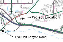 A project has been approved for
future consideration of funding to construct the Live Oak Canyon
Interchange in the City of Yucaipa (TCRP #59). [April 2002 Agenda Item
2.2c.(3)]. The overall project is to reconstruct the Live Oak Canyon Road
Interchange on Route 10 (~ 010 SBD R36.966) and construct the 14th
Street Bridge over Wilson Creek (~ 010 SBD R37.252). Construction of the
14th Street Bridge was completed in December 2003. In 2007, the
CTC considered a request for modification of funding on this project,
which would place the completion date in FY 2008/09
A project has been approved for
future consideration of funding to construct the Live Oak Canyon
Interchange in the City of Yucaipa (TCRP #59). [April 2002 Agenda Item
2.2c.(3)]. The overall project is to reconstruct the Live Oak Canyon Road
Interchange on Route 10 (~ 010 SBD R36.966) and construct the 14th
Street Bridge over Wilson Creek (~ 010 SBD R37.252). Construction of the
14th Street Bridge was completed in December 2003. In 2007, the
CTC considered a request for modification of funding on this project,
which would place the completion date in FY 2008/09
In February 2020, it was reported that Measure I is also funding the
I-10/University Street Interchange (~ SBD 31.915), scheduled to begin
construction in spring 2020, according to SanBAG. The $5.5 million project
will improve University Street at the I-10 interchange between Citrus
Avenue and Central Avenue, and also implement minor ramp widening, add
turning lanes, traffic signals and operational improvements within the
existing right-of-way. The project will reduce congestion and improve
traffic operations. The project is scheduled to be completed by the spring
of 2021. The interchange serves the east end of Redlands, and provides
access to the University of Redlands, Redlands High School and a large
residential community. Additionally, and also funded by Measure I, last
September the Redlands City Council approved a five-year capital project
that includes intersection improvements at University Street and Colton
Avenue, and new signals at Ford Street and I-10. The capital project also
includes widening of Pioneer Avenue from Furlow Drive to Texas Street from
two to four lanes, widening of Citrus Avenue from Dearborn Street to
Wabash Avenue from two to four lanes and widening of San Bernardino Avenue
from Church Street to Wabash Avenue from two to four lanes.
(Source: Highland News, 2/20/2020)
Route 10 Eastbound Truck Climbing Lane (08-SBd-10, PM 36.4/R39.2 08-Riv-10, PM R0.0/R0.2)
 The 2018 STIP, approved at the CTC March 2018 meeting, appears to allocate Advance Project Development Element (APDE) funds of $2.890M for PS&E for PPNO
3009Q Rt 10 Eastbound Truck Climbing Lane. Per the San Bernardino County Transportation Authority MAJORPROJECTS
PROJECT STATUS REPORT, April–
June 2017, this project will add a truck climbing lane from west of
the 16th Street Bridge in the City of Yucaipa (SBD 036.44) to
east of the County Line Road Bridge at the San Bernardino County and
Riverside County line (RIV 0.0). Funding for the project is presently
programmed only through the Project Approval and Environmental Document
(PA/ED) phase. The amount is equal to the final design cost. Construction
is expected in 2020.
The 2018 STIP, approved at the CTC March 2018 meeting, appears to allocate Advance Project Development Element (APDE) funds of $2.890M for PS&E for PPNO
3009Q Rt 10 Eastbound Truck Climbing Lane. Per the San Bernardino County Transportation Authority MAJORPROJECTS
PROJECT STATUS REPORT, April–
June 2017, this project will add a truck climbing lane from west of
the 16th Street Bridge in the City of Yucaipa (SBD 036.44) to
east of the County Line Road Bridge at the San Bernardino County and
Riverside County line (RIV 0.0). Funding for the project is presently
programmed only through the Project Approval and Environmental Document
(PA/ED) phase. The amount is equal to the final design cost. Construction
is expected in 2020.
In February 2020, it was reported that a $30.2 million
I-10 Truck Climbing Lane is on the drawing table and is expected to begin
construction in winter of 2021. According to the Transportation Authority,
the project will add a truck climbing lane from west of the 16th
Street Bridge in Yucaipa to just east of the County Line Road Bridge at
the San Bernardino County and Riverside County line. The project will
separate slow-moving trucks that are climbing the steep grade along the
project from the general traffic lanes, said the Transportation Authority.
Funding for this project will come from the state and Measure I. It is
expected to be completed by spring of 2022.
(Source: Highland News, 2/20/2020)
The 2020 STIP, approved at the March 2020 CTC meeting,
continued the programmed funding of $2,890K for PPNO 3009Q "Rt 10
Eastbound Truck Climbing Lane (APDE)(ext 5-19)", but pushed the funds from
a prior year to FY23-24.
(Source: March 2020 CTC Agenda, Item 4.7, 2020 STIP
Adopted 3/25/2020)
In January 2021, the CTC approved for future
consideration of funding 08-SBd-10, PM 36.4/R39.2 08-Riv-10, PM
R0.0/R0.2. I-10 Eastbound Truck Climbing Lane Improvement
Project. Extend the eastbound truck climbing lane on I-10 from its
current terminus, at the eastbound off-ramp to the Live Oak interchange,
to eastbound of the County Line Road off-ramp, at the San Bernardino
County and Riverside County line. (MND) (PPNO 3009Q) (STIP) . This project
is located on I-10 from the 16th Street Overcrossing in Yucaipa
to 0.2 miles east of the County Line Road Overcrossing in Calimesa.
The San Bernardino County Transportation Authority (SBCTA), in cooperation
with Caltrans, will extend the eastbound (EB) truck climbing lane on I-10
within the project limits. The project is not fully funded. The
project is currently programmed in the 2020 STIP for Plans, Specifications
and Estimates and Construction Capital for $5,780,000. The project
also includes local funding of $9,298,000. The total project cost is
estimated to be $27,050,000 with construction estimate to begin in
2022-23. The scope, as described for the preferred alternative, is
consistent with the project scope programmed by the Commission in the 2020
STIP. A Mitigated Negative Declaration (MND) has been completed. The
project will result in less than significant impacts to the environment
after mitigation. The following resource areas may be impacted by
the project: Geology and Soils. Avoidance and minimization measures
will reduce any potential effects on the environment. These measures
include, but are not limited to, preparation of a paleontological
mitigation plan by a qualified Project Paleontologist/Principal
Investigator prior to completion of the final project design phase for
project-related ground disturbance in areas of paleontological
sensitivity.
(Source: January 2021 CTC Agenda, Agenda Item
2.2c.(1))
In January 2021, the CTC approved the following STIP
allocation: $2,890,000 (PS&E). 08-SBd-10 R36.4/R39.2 & R0.0/R0.2.
PPNO 08-3009Q; ProjID 0815000050; EA 1F760. I-10 Eastbound Truck
Climbing Lane. I-10 In San Bernardino County, from the 16th
Street Overcrossing in Yucaipa to 0.2 miles east of the County Line Road
Overcrossing in Calimesa (Riverside) . Construct a truck climbing lane in
the eastbound direction. (Concurrent consideration of funding approved
under Resolution E-21-08; January 2021.) (Time extension for FY 18-19
PS&E expires February 28, 2021)
(Source: January 2021 CTC Agenda, Agenda Item
2.5c.(2))
In January 2023, the CTC approved for future
consideration of funding the following project for which a MND and
an Addendum have been completed: 08-Riv-10, PM R0.0/R0.2, 08-SBd-10, PM
36.4/R39.2. I-10 Eastbound Truck Climbing Lane Improvement Project.
I-10 in Riverside and San Bernadino Counties. Extend the eastbound truck
climbing lane on I-10 from its current terminus, at the eastbound off-ramp
to the Live Oak interchange, to eastbound of the County Line Road
off-ramp, in Riverside and San Bernadino Counties. (PPNO 3009Q) This
project is located on I-10 from the 16th Street Overcrossing in
Yucaipa to 0.2 miles east of the County Line Road Overcrossing in
Calimesa. The San Bernardino County Transportation Authority, in
cooperation with the Department, will extend the eastbound truck climbing
lane on I-10 within the above described project limits. The project is
currently programmed in the 2022 State Transportation Improvement Program
(STIP), which includes Senate Bill 1 (SB 1) Transportation Corridors
Enhancement Program (TCEP) funding of $30,264,000 in Construction
(capital). The total project cost is $36,093,000 with construction
estimate to begin in 2022-23. The scope, as described for the preferred
alternative, is consistent with the project scope programmed by the
Commission in the 2022 STIP. A MND was prepared because of potential
biological resource impacts. A copy of the MND has been provided to
Commission staff. The Commission approved the project for future
consideration of funding on January 28, 2021, under Resolution E-21-08.
Changes to the scope include the addition of rock slope protection in
Wilson Creek, installation of new localized drainage systems, and access
to an existing flood control channel. The Department subsequently
completed an Addendum to the MND pursuant to the California Environmental
Quality Act. The Department has approved this project for construction.
This approval and the Addendum will satisfy the environmental requirements
for this stage of the planning process.
(Source: January 2023 CTC Agenda, Agenda Item 2.2c.(5))
In January 2023, the CTC approved an allocation of
$24,074,000 for the locally-administered Senate Bill 1 (SB 1) Trade
Corridor Enhancement Program (TCEP) I-10 Eastbound Truck Climbing Lane in
Yucaipa project (PPNO 3009Q), on the State Highway System, in San
Bernardino County: 08-SBd-10 R36.4/R39.4. PPNO 08-3009Q; ProjID
0815000050; EA 1F760. I-10 Eastbound Truck Climbing Lane in Yucaipa.
On I-10 In San Bernardino County, from the 16th Street
Overcrossing in Yucaipa to 0.2 miles east of the County Line Road
Overcrossing in Calimesa (Riverside) . Construct a truck climbing lane in
the eastbound direction. CEQA - MND, 11/10/2020; Re-validation 11/23/2022.
NEPA - FONSI, 11/10/2020; Re-validation 11/23/2022. Right of Way
Certification: 04/22/2022. Contribution from other sources: $6,190,000.
Future consideration of funding approved under Resolution E-21-08; January
2021. Time extension for FY 21-22 CONST expires on 06/30/2023. The CTC
approved an addendum for the previously approved Future Consideration of
Funding under Resolution E-23-11; January 2023. TCEP-R/21-22 CONST
$14,444,000; TCEP-S/21-22 CONST $9,630,000.
(Source: January 2023 CTC Agenda, Agenda Item 2.5s.(5))
In December 2023, the CTC approved the following
supplemental allocation for a Locally-Administered TCEP Project: $791,000.
08-SBd-10 R36.4/R39.2. PPNO 08-3009Q; ProjID 0815000050; EA 1F760. I-10
Eastbound Truck Climbing Lane in Yucaipa. In San Bernardino County,
from the 16th Street Overcrossing in Yucaipa to 0.2 miles east
of the County Line Road Overcrossing in Calimesa (Riverside) . Construct a
truck climbing lane in the eastbound direction. Supplemental funds are
needed to Award. CEQA - MND, 11/10/2020; Re-validation 11/23/2022 NEPA -
FONSI, 11/10/2020; Re-validation 11/23/2022 Future consideration of
funding approved under Resolution E-21-08; January 2021. Total revised
amount $24,865,000. In August 2023, the SBCTA advertised the contract and
held bid opening in October 2023. The contract received four bids,
of which the lowest bid is approximately 23 percent above the
Engineer’s Estimate (EE). The three remaining bids range from
approximately 32 to 71 percent over the EE. The EE was last updated in
March of 2023 using the latest unit prices for materials from similar
regional projects. The project’s location and staging of the
work was factored into the estimate, however, the bids were above the EE
on certain items. The cost increases on this project are primarily
attributed to the increase in the unit price of concrete and labor.
(Source: December 2023 CTC Agenda, Agenda Item 2.5s.(2))
Beaumont (Jct Route 60) (~ 010 RIV 6.651) to near Whitewater (Jct Route 111) (~ 010 RIV R25.185)
I-10 Tune Up (~ RIV 8.211 to RIV R24.822)
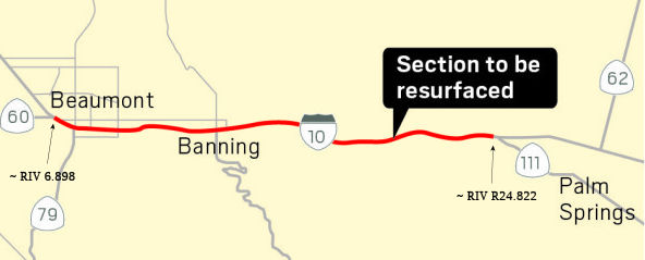 In December 2016, it was reported that the CTC approved a
project on I-10 in Beaumont from Pennsylvania Avenue (~ 010 RIV 8.211) to
the I-10/Route 111 separation to replace lanes 3 and 4 and outside
shoulders with JPCP, overlay inside shoulder, concrete slab replacement
Lane and upgrade curb ramps lanes 1 and 2. The cost will be $162,231,000,
starting fall 2018 and completion winter 2019.
In December 2016, it was reported that the CTC approved a
project on I-10 in Beaumont from Pennsylvania Avenue (~ 010 RIV 8.211) to
the I-10/Route 111 separation to replace lanes 3 and 4 and outside
shoulders with JPCP, overlay inside shoulder, concrete slab replacement
Lane and upgrade curb ramps lanes 1 and 2. The cost will be $162,231,000,
starting fall 2018 and completion winter 2019.
(Source: Valley News, 12/2/2016)
In February 2020, it was reported that Caltrans was
launching a major $210 million pavement renovation project on I-10 from
Beaumont to Palm Springs. The work to repair and replace brittle sections
of decades-old concrete is spread 17 miles between Route 60 and Route 111.
Drivers will have to factor the project into desert travel plans through
2022, when work is scheduled to wrap up. Crews will replace damaged
concrete slabs in the freeway’s No. 1 and 2 lanes, and repave whole
sections of the heavily damaged No. 3 and 4 outside lanes. Much of the
pavement was built in the 1960s, and some of the slabs still date to the
original construction. The existing slabs range from three-quarters of a
foot to a foot thick, and they will be replaced by 1.3-feet-deep concrete.
The initial work is focused on the area between 8th Street in
Banning and Main Street in Cabazon. According to the project website, work
will concentrate in Beaumont and Banning for several months, shift to the
Cabazon area in the fall and then move to the area east of Cabazon to
Route 111 in fall 2021. Most of the time three of four lanes on the side
of the freeway being worked on will remain open. However, drivers will
have to navigate places where temporary lanes cross over to the other
side. More than half the cost — $116 million — will be paid
out of proceeds from the recent Senate Bill 1 gas tax increase.
(Source (and image source): Press Enterprise, 2/5/2020)
Apache Trail Interchange
TCRP Project #61 will reconstruct the Apache Trail Interchange E of Banning in Riverside County (~ 010 RIV R17.678). As of September 2005, this project is inactive.
In June 2017, the CTC was informed RCTC will be unable to utilize $2,678,000 of TCRP funding on TCRP Project 61 (Apache Trail Interchange) by the June 30, 2017 deadline. RCTC would like to transfer the unused savings in TCRP funding to Kern COG for TCRP Project 113 – Route 46 Expressway, Segment 4A.
Cabazon Movable Barrier Project / Banning-Cabazon Bypass Road
In May 2011, Caltrans replaced standard median near Cabazon with removable K-rails. The new barriers were installed 1.2 miles east of Main Street (~ 010 RIV R20.605) in Cabazon and 1.7 miles west of Haugen-Lehmann Way (~ 010 RIV R22.847), in Whitewater. The new medians allow CHP officers to redirect traffic to opposite lanes or onto side streets where they can re-enter the freeway at a point past a crash. Riverside County and state officials are also planning two bypass roads through Cabazon and Banning that could serve as alternate routes. Caltrans is also planning addition median breaks in 2012 with more K-rail barriers.
Additional information was provided in October 2012.
The plan is for a series of street improvements and additions would form
the backbone of an I-10 bypass system in the San Gorgonio Pass that could
ease crippling traffic jams when the freeway has to be shut down. Caltrans
will install gates in the freeway medians in case crews need to shift
east- and westbound traffic to one side of the freeway. Also, Caltrans and
CHP will partner with the county on message signs and other improvements
that will help police redirect traffic and give drivers accurate knowledge
of traffic jams when they happen. The County agreed to work on four
separate road connections in the Pass and contribute other resources
during traffic jams. South of I-10, the county would oversee the most
critical link — connecting Hathaway Street in Banning (~ 010 RIV
14.388) to Apache Trail near Cabazon (~ 010 RIV R17.678) via a two-lane
road. The project, commonly called the Westward Avenue extension because
one option would bring Westward eastward to Apache, will cost about $20
million because of the terrain. South of the freeway, the county will work
to find the money to extend Garnet Road (~ 010 RIV 29.061) to Whitewater
Cutoff Road. North of the freeway, the county will look for the money to
extend Tamarack Road from Mesquite Road (~ 010 RIV R24.797) to Whitewater
Cutoff Road northeast of Route 111 (~ 010 RIV 27.4). Lastly, it will
partner with Morongo tribe officials to extend Seminole Road eastward to
Rushmore Avenue. Combined, the road extensions, freeway median
improvements and adding changeable message signs, video cameras and other
systems to the freeway are estimated to cost $40 million.
(Source: Press-Enterprise, 10/15/12)
In June 2014, it was reported that construction was
scheduled to start near the end of 2014 on the extension of a road that
runs parallel to I-10 in Cabazon. Once Seminole Drive (near ~ 010 RIV
R19.324) is connected to Rushmore Avenue (~ 010 RIV R22.761) — a
process expected to finish in March 2015 — drivers will have an
alternate route in case of emergency lane closures on westbound I-10.
Construction costs about $800,000 and funding will come from a portion of
tax revenue from the Desert Hills Premium Outlets’ expansion.
Officials also plan to build a bypass between Cabazon and Banning, but
that portion of the project is in its early stages. In May 2014, workers
finished installing five gates in I-10’s center median. The gates
— two west and three east of Cabazon — serve as access points
to opposite lanes along I-10 between Banning and Palm Springs. It will be
up to California Highway Patrol officers to open the gates and direct
traffic onto the opposite lanes whenever necessary.
(Source: The Desert Sun, 6/21/14)
In August 2014, it was reported that five median gates have been completed. The gates are located along a 19-mile stretch that has experienced several incidents in the past that have caused lengthy traffic delays, stranding motorists because there is no alternate route if the freeway is closed. Gates are located near the Hargrave Street under-crossing in Banning; west of Malki Road in Cabazon; east of Main Street in Cabazon; west of Haugen-Lehmann Way in Whitewater and west of the I-10/Route 62 separation near Palm Springs. These gates will only be used for major incidents (over an hour). The decision on when to open the gates will be made jointly by the California Highway Patrol, Caltrans and, if necessary, other public safety agencies. The 60-foot steel median gate barriers are the first of their kind in the state.
In January 2018, it was reported that an environmental
report on the project to construct a bypass road between Banning and
Cabazon has been created and will be discussed at a meeting in late
January 2018. The Riverside County Transportation Department wants to
build a road between Banning and Cabazon that will link the communities
and offer an alternate route in case of a freeway closure. The proposal is
to build a two-lane road extending approximately 3.3 miles from the
intersection of Hathaway Street and Westward Avenue in Banning east to the
intersection of Bonita Avenue and Apache Trail in Cabazon. The project
includes bridges over Smith Creek and the San Gorgonio River, paving of
two lanes, a median, paved shoulders, drainages, a shared use path and
sidewalks. Talks of an alternate route have been underway for at least a
decade and 14 alternatives were considered before the final two were
chosen. The public has until Feb. 13 to comment on the project before a
preferred alternative is selected and the document is finalized. The final
environmental document is expected to be approved by the end of 2018.
Then, the design and other phases of the project could begin.
(Source: Press Enterprise, 1/23/2018)
In August 2011, the CTC approved $1,826,000 in SHOPP funding for repairs near Cabazon at East Channel Stubby Wash Bridge (#56- 0168L) (010 RIV R024.24) that will widen and rehabilitate two bridges to extend the service life of the structures.
Route 111 (Whitewater) (~ 010 RIV R25.185) to Indio (Route 86) (~ 010 RIV R57.397)
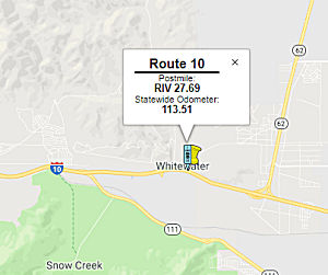 In August 2018, the CTC approved for future consideration
of funding the following project for which a Negative Declaration (ND) has
been completed: I-10 in Riverside County (08-Riv-10, PM 27.69).
Rehabilitate two existing bridges on I-10 near the city of Palm Springs.
(PPNO 3002F) This project is located on I-10, west of the city of Palm
Springs in Riverside County. The project proposes to rehabilitate the
Whitewater River Bridges (No. 56-004L and No. 56-004R). The project
proposes to strengthen existing bridge footings with additional piles,
pile caps and permanent grouted Rock Slope Protection. The proposed
project is currently estimated to cost $11.1 million in capital and right
of way. The project is fully funded and is currently programmed in the
2016 SHOPP for approximately $17.3 million which includes Construction
(capital and support) and Right-of-Way (capital and support). The project
is estimated to begin construction in 2020. The scope, as described for
the preferred alternative, is consistent with the project scope programmed
by the Commission in the 2016 SHOPP.
In August 2018, the CTC approved for future consideration
of funding the following project for which a Negative Declaration (ND) has
been completed: I-10 in Riverside County (08-Riv-10, PM 27.69).
Rehabilitate two existing bridges on I-10 near the city of Palm Springs.
(PPNO 3002F) This project is located on I-10, west of the city of Palm
Springs in Riverside County. The project proposes to rehabilitate the
Whitewater River Bridges (No. 56-004L and No. 56-004R). The project
proposes to strengthen existing bridge footings with additional piles,
pile caps and permanent grouted Rock Slope Protection. The proposed
project is currently estimated to cost $11.1 million in capital and right
of way. The project is fully funded and is currently programmed in the
2016 SHOPP for approximately $17.3 million which includes Construction
(capital and support) and Right-of-Way (capital and support). The project
is estimated to begin construction in 2020. The scope, as described for
the preferred alternative, is consistent with the project scope programmed
by the Commission in the 2016 SHOPP.
(Source: August 2018 CTC Agenda Item 2.2c(1))
Indian Canyon Drive Interchange
The SAFETEA-LU act, enacted in August 2005 as the reauthorization of TEA-21, provided the following expenditures on or near this route:
In April 2009, the CTC approved for future consideration of funding a project in Riverside County will reconstruct the Indian Canyon Drive/I-10 interchange (~ 010 RIV 33.123) and construct roadway improvements, including a sidewalk on the west side, a bike lane in each direction, realignment of the eastbound and westbound direct on- and off-ramps, and widening of 20th Avenue and Garnet Avenue. The project is programmed in the 2008 State Transportation Improvement Program, and includes local and federal funds. Total estimated cost is $35,098,000, capital and support. Construction is estimated to begin in Fiscal Year 2009-10.
In August 2015, the CTC authorized relinquishment of right of way in the city of Palm Springs at Indian Canyon Drive and 20th Avenue, consisting of reconstructed city streets (08-Riv-10-PM 33.1).
In June 2016, the CTC authorized relinquishment of right of way in the city of Desert Hot Springs along Route 10 at Indian Canyon Drive and 20th Avenue (08-Riv-10-PM 33.1), consisting of a collateral facility. The City, by freeway agreement dated December 9, 2015, agreed to accept title upon relinquishment by the State. The 90-day notice period expired May 8, 2016.
Date Palm Drive Interchanges
The SAFETEA-LU act, enacted in August 2005 as the reauthorization of TEA-21, provided the following expenditures on or near this route:
In April 2009, the CTC approved for future consideration of funding a project in Riverside County will reconstruct the Date Palm Drive/Gene Autry Trail interchange (~ 010 RIV 36.153) and construct roadway improvements, including a sidewalk and bike lane in each direction. The project is programmed in the 2008 State Transportation Improvement Program and includes local and federal funds. Total estimated cost is $38,603,000 capital and support. Construction is estimated to begin in Fiscal Year 2009-10. In July 2009, the CTC approved an amendment regarding reconstruction of the interchange. The project will modify the existing Route 10/Palm Drive Interchange from diamond configuration to a partial cloverleaf configuration with east and westbound loop entrance ramps and will construct a bridge structure over Route 10 to accommodate additional lanes. This is TCRP Project #146.
In February 2010, the CTC approved for future consideration of funding a project to reconstruct an existing interchange at I-10 and Date Palm Drive in Cathedral City. Additional improvements will include widening the existing overcrossing from two to six lanes and the addition of bike lanes and sidewalks. The project is programmed in the 2008 State Transportation Improvement Program. The total estimated project cost is $31,721,000 for capital and support. Construction is estimated to begin in Fiscal Year 2009-10. A Mitigated Negative Declaration (MND) has been completed; the project will involve construction activities resulting in visual effects that will be addressed by aesthetic treatments. Construction activities will also occur in an area containing the Coachella Valley milk-vetch, a federally listed plant species of concern.
In June 2017, the CTC was informed that Riverside County Transportation Commission (RCTC) will be unable to utilize $1,648,000 of TCRP funding on TCRP Project 146 (Palm Drive Interchange) by the June 30, 2017 deadline. RCTC would like to transfer the unused savings in TCRP funding to Kern COG for TCRP Project 113 – Route 46 Expressway, Segment 4A.
![[Bob Hope Interchange]](maps/010-bobhope.jpg) In November 2006, the CTC
considered a route adoption to construct a roadway extension and a new
eight lane overcrossing over I-10, near Bob Hope Drive (~ 010 RIV 42.979).
In the vicinity of the proposed Bob Hope Drive interchange, I-10 is an
eight-lane divided freeway. The existing Ramon Road interchange was
constructed in 1961. The proposed project will construct a new spread
diamond interchange with Bob Hope Drive. The interchange will be located
approximately 0.4 miles west of the existing Ramon Road interchange and
will be a new six-lane overhead structure over the Union Pacific Railroad
and an eight-lane overcrossing structure over I-10. The existing Ramon
Road eastbound on-ramp will remain operational while the other four ramps
at Ramon Road will be removed. Keeping the eastbound on-ramp at Ramon Road
will improve the operating conditions at the local street intersections.
The proposed improvements will increase the capacity of the existing
interchange and improve interchange operations. This project is fully
funded in the 2006 State Transportation Improvement Program. The total
estimated project cost is $53,700,000. This project requires full
oversight by the Federal Highway Administration (FHWA) since it is a
federally-funded project on the interstate system that involves the
reconstruction of an interchange and is greater than $1.0 million. A FHWA
field operations engineer reviewed the project on April 12, 2006. A
Modified Access Report was approved by FHWA on February 15, 2002. This
project is consistent with the Regional Transportation Plan and the
Riverside County General Western Coachella Circulation Plan. As a
“Gateway Interchange” to Rancho Mirage, all improvements,
including aesthetic treatment, landscaping, and restoration of natural
areas will be based on the conceptual plans provided by the Agua Caliente
Band of Cahuilla Indians. A public information meeting was held in
November 2001 to solicit public input. It is estimated to begin
construction in Fiscal Year 2007-2008.
In November 2006, the CTC
considered a route adoption to construct a roadway extension and a new
eight lane overcrossing over I-10, near Bob Hope Drive (~ 010 RIV 42.979).
In the vicinity of the proposed Bob Hope Drive interchange, I-10 is an
eight-lane divided freeway. The existing Ramon Road interchange was
constructed in 1961. The proposed project will construct a new spread
diamond interchange with Bob Hope Drive. The interchange will be located
approximately 0.4 miles west of the existing Ramon Road interchange and
will be a new six-lane overhead structure over the Union Pacific Railroad
and an eight-lane overcrossing structure over I-10. The existing Ramon
Road eastbound on-ramp will remain operational while the other four ramps
at Ramon Road will be removed. Keeping the eastbound on-ramp at Ramon Road
will improve the operating conditions at the local street intersections.
The proposed improvements will increase the capacity of the existing
interchange and improve interchange operations. This project is fully
funded in the 2006 State Transportation Improvement Program. The total
estimated project cost is $53,700,000. This project requires full
oversight by the Federal Highway Administration (FHWA) since it is a
federally-funded project on the interstate system that involves the
reconstruction of an interchange and is greater than $1.0 million. A FHWA
field operations engineer reviewed the project on April 12, 2006. A
Modified Access Report was approved by FHWA on February 15, 2002. This
project is consistent with the Regional Transportation Plan and the
Riverside County General Western Coachella Circulation Plan. As a
“Gateway Interchange” to Rancho Mirage, all improvements,
including aesthetic treatment, landscaping, and restoration of natural
areas will be based on the conceptual plans provided by the Agua Caliente
Band of Cahuilla Indians. A public information meeting was held in
November 2001 to solicit public input. It is estimated to begin
construction in Fiscal Year 2007-2008.
In March 2015, the CTC authorized relinquishment of right of way in the county of Riverside at Bob Hope Drive, consisting of a reconstructed county road (08-Riv-10-PM 43.0). They also authorized relinqishment of right of way in the city of Rancho Mirage at Bob Hope Drive, Varner Road, and Rio del Sol Road, consisting of a reconstructed city street (08-Riv-10-PM 43.0). The County of Riverside, by freeway agreement dated August 29, 2006, agreed to accept title upon relinquishment by the State to roads which on that date were within an unincorporated area of the county and have since been annexed by the City.
In June 2015, the CTC authorized relinquishment of right of way in the city of Cathedral City on Bob Hope Drive, Varner Road, and Rio Del Sol Road, consisting of reconstructed city streets. The county of Riverside, by freeway agreement dated August 29, 2006, agreed to accept title to highway right of way that now lies within Cathedral City, upon relinquishment by the State.
In March 2013, the CTC approved for future consideration of funding a project that will reconstruct the westbound ramps at the I-10/Monterey Avenue Interchange (~ 010 RIV 44.496) in the community of Thousand Palms. The project is programmed in the Proposition 1B State-Local Partnership Program. The total estimated cost is $12,699,000 for capital and support. Construction is estimated to begin in Fiscal Year 2012-13. In May 2013, the CTC allocated $2,800,000 for this project.
Portola Road Interchange (08-Riv-10, PM 44.8/46.6)
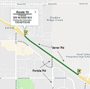 In October 2018, the CTC approved for future
consideration of funding the following project for which a Negative
Declaration (ND) has been completed: I-10 in Riverside County (08-Riv-10,
PM 44.8/46.6). Construct a new interchange on I-10 at Portola Rd in the
city of Palm Desert. (EA 08-0F1200) This project is located on I-10 in the
city of Palm Desert. The project proposes a new interchange at Portola Rd.
The proposed project will include a new structure crossing the I-10 and
the Union Pacific Railroad, on and off ramps, and realignment of the
adjacent frontage road, Varner Road. In addition, the proposed project
will construct auxiliary lanes in each direction on I-10 between the new
Portola Rd ramps and adjacent Cook Street/Monterey Avenue Interchanges.
The proposed project is needed to address increased forecasted travel
demand and growing congestion on I-10. The proposed project is fully
funded from Local and city funds and estimated to cost approximately $79.8
million. Construction is estimated to begin in Fiscal Year 2019-20.
In October 2018, the CTC approved for future
consideration of funding the following project for which a Negative
Declaration (ND) has been completed: I-10 in Riverside County (08-Riv-10,
PM 44.8/46.6). Construct a new interchange on I-10 at Portola Rd in the
city of Palm Desert. (EA 08-0F1200) This project is located on I-10 in the
city of Palm Desert. The project proposes a new interchange at Portola Rd.
The proposed project will include a new structure crossing the I-10 and
the Union Pacific Railroad, on and off ramps, and realignment of the
adjacent frontage road, Varner Road. In addition, the proposed project
will construct auxiliary lanes in each direction on I-10 between the new
Portola Rd ramps and adjacent Cook Street/Monterey Avenue Interchanges.
The proposed project is needed to address increased forecasted travel
demand and growing congestion on I-10. The proposed project is fully
funded from Local and city funds and estimated to cost approximately $79.8
million. Construction is estimated to begin in Fiscal Year 2019-20.
(Source: October 2018 CTC Agenda Item 2.2c.(1))
In May 2020, the CTC approved for future consideration
of funding the I-10/Portola Avenue New Interchange Project
(08-Riv-10, PM 44.8/46.6), which will construct a new interchange in
Riverside County (EA 0F1200). The project is located in Riverside County
in the City of Palm Desert on I-10 and proposes to construct a new
interchange at Portola Avenue (sic). The purpose of the project is to
reduce existing and forecasted traffic congestion on Monterey Avenue and
Cook Street intersections near I-10, to improve traffic operations, and
provide a balanced circulation system. This project is fully funded
through the construction phase and is funded through local funds. The
total estimated project cost is $81,148,000. Construction is estimated to
begin Fiscal Year 2020-2021.
(Source: May 2020 CTC Agenda, Agenda Item 2.2c.(1))
In June 2020, the CTC approved a new Public Road
Connection to I-10 at Portola Avenue (08- RIV-10- PM 45.8) in the City of
Palm Desert, in Riverside County. The proposed project will extend Portola
Avenue, a north-to-south arterial, northerly from Dinah Shore Drive to
Varner Road and construct a new interchange at I-10 (PM 45.8). The new
interchange will be approximately 1.2 miles east of the Monterey Avenue
interchange and 1.2 miles west of the Cook Street interchange. Auxiliary
lanes on I-10 will also be constructed between the new Portola Avenue and
the adjacent interchanges. The I-10/Portola Avenue Interchange project
originated in the planning stages (2002-2003) as developments within the
City of Palm Desert pushed toward the I-10 corridor, taking advantage of
the available vacant land along the northern city limits. In July 2002,
the Coachella Valley Association of Governments Executive Committee
approved the inclusion of the interchange project in the Transportation
Project Prioritization Study. The Project Study Report for the
I-10/Portola Avenue interchange in the City of Palm Desert was approved by
the Department on April 28, 2005. The interchange and associated
improvements address both current and future traffic demands in the
region. The construction of a new interchange at Portola Avenue will
improve the operations of the adjacent interchanges and arterial roads by
providing a new point of direct access to I-10. Traffic studies indicate
that the new connection will not adversely impact the safety and
operations of I-10, and no other measures need to be considered in
addition to the proposed auxiliary lanes. The interchange should operate
at an acceptable level of service through 2040. Furthermore, traffic
operations at the neighboring arterial intersections are expected to
improve. The current cost for construction, construction support, and
right-of-way acquisition is $60.7, $7.2 and $5.2 million, respectively.
The project is anticipated to be funded through a combination of local
funds and federal funding sources, such as Surface Transportation Program
funds. A freeway agreement between the Department and Riverside County was
signed by the Riverside County Board of Supervisors on October 1, 2019.
The freeway agreement will be executed by the Department after the
Commission’s approval of the new public road connection.
(Source: June 2020 CTC Agenda, Agenda Item 2.3b)
In August 2014, the CTC authorized $33,310,000 for the Jefferson Street Interchange (~ 010 RIV R52.492) in the city of Indio. This project includes construction of a new partial cloverleaf interchange with standard diamond ramps, hook entrance ramps, and a new eight-lane overcrossing over the I-10.
Indio (Route 86) (~ 010 RIV R57.397) to the Arizona Border
Coachella Climbing Lanes (08-Riv-10 R60.7/R74.3)
 In October 2017, the CTC added the following into the
SHOPP: 08-Riv-10 R60.9/R74.0: On I-10 in Riverside County: In and near
Coachella, from 0.5 mile east of Coachella Canal to Hazy Gulch Bridge.
Cold plane pavement and overlay with Portland Cement Concrete (PCC).
Construct eastbound truck climbing lane. A one-lane temporary detour will
be constructed in the median for traffic handling.
In October 2017, the CTC added the following into the
SHOPP: 08-Riv-10 R60.9/R74.0: On I-10 in Riverside County: In and near
Coachella, from 0.5 mile east of Coachella Canal to Hazy Gulch Bridge.
Cold plane pavement and overlay with Portland Cement Concrete (PCC).
Construct eastbound truck climbing lane. A one-lane temporary detour will
be constructed in the median for traffic handling.
In January 2020, there was a technical amendment to
this SHOPP item: 08-Riv-10 R60.9/R74.0. PPNO 3008A. ProjID 0816000086. EA
1C081. I-10 in and near Coachella, from 0.5 mile east of Coachella Canal
to Hazy Gulch Bridge. Cold plane pavement and overlay with Portland Cement
Concrete (PCC). Construct eastbound truck climbing lane. A one-lane
one lane temporary detour will be constructed in the median for
traffic handling. Construction is not yet programmed. The amendment was an
adjustment in the project support and engineering costs.
(January 2020 CTC Agenda, Agenda Item 2.1a.(1d),
Item 22)
The 2020 SHOPP, approved in May 2020, included the
following Roadway Rehabilitation item of interest (carried over from the
2018 SHOPP): 08-Riverside-10 PM R60.9/R74.0 PPNO 3008A Proj ID 0816000086
EA 1C081. I-10 in and near Coachella, from 0.5 mile east of Coachella
Canal to Hazy Gulch Bridge. Cold plane pavement and overlay with Portland
Cement Concrete (PCC). Construct eastbound truck climbing lane. A one lane
temporary detour will be constructed in the median for traffic handling.
Programmed in FY21-22, with construction scheduled to start in July 2022.
Construction capital and construction support phases are not yet
programmed/funded. Total project cost is $196,100K, with $157,010K
being capital (const and right of way) and $39,090K being support
(engineering, environmental, etc.).
(Source: 2020 Approved SHOPP a/o May 2020)
In December 2020, the CTC approved for future
consideration of funding the following project for which a Mitigated
Negative Declaration (MND) has been completed: I-10 in Riverside County
(8-Riv-10, PM R60.7/R74.3). Rehabilitate existing pavement, ramps, and
guardrail, install an eastbound truck climbing lane, install electric
vehicle charging stations, and update ADA facilities on I-10 in Riverside
County. (EA 3008A) This project is located in Riverside County, I-10 near
Coachella, post miles R60.7/R74.3. The Department proposes to rehabilitate
a portion of I-10 from 2.0 miles east of the Dillon Road Interchange to
2.0 miles east of Cactus City Rest area at post mile R60.7 to post mile
74.0. This project is not fully funded and is currently programmed in the
2020 SHOPP for a total of $196,100,000 of which $179,000,000 is currently
through G-13 Contingency. Construction is estimated to begin 2021-2022.
The scope, as described for the preferred alternative, is consistent with
the project scope programmed by the Commission in the 2020 SHOPP.
(Source: December 2020 CTC Agenda, Agenda Item
2.2c.(1))
In January 2021, the CTC amended the 2020 SHOPP related
to this project: (1b) #13. 08-Riv-10 R60.9/R74.0 R60.7/R74.3
PPNO 3008A ProjID 0816000086 EA 1C081. I-10 in and near Coachella, from 0.5
0.3 mile east of Coachella Canal to 0.2 mile east of
Hazy Gulch Bridge. Cold plane pavement and overlay with Portland Cement
Concrete (PCC). Construct eastbound truck climbing lane. A one
lane temporary detour will be constructed in the median for traffic
handling. Amended to change postmiles to accommodate transition tapers and
signage. Increase R/W capital from $10K to $13,991K for mitigation related
to usage of the median for traffic staging, which impacts desert tortoise
habitat, permit fees, application fees, and mitigation related to bridge
widening. Revised total is now $210,081K.
(Source: January 2021 CTC Agenda, Agenda Item
2.1a.(1b) #13)
In May 2021, the CTC approved the following
pre-construction SHOPP SB1 support phase allocation(s): (2b) #6.
$2,000,000 (PS&E; $10,000,000 programmed); $90,000 (R/W Sup).
08-Riv-10 R60.7/R74.3. PPNO 08-3008A; ProjID 0816000086; EA 1C081. I-10 In
and near Coachella, from 0.3 mile east of Coachella Canal to 0.2 mile east
of Hazy Gulch Bridge. Cold plane pavement and overlay with Portland Cement
Concrete (PCC). Construct eastbound truck climbing lane. A one lane
temporary detour will be constructed in the median for traffic handling.
(Future consideration of funding approved under Resolution E-20-121;
December 2020.) Prog year 21-22.
(Source: May 2021 CTC Agenda, Agenda Item 2.5b.(2b)
#6)
In June 2021, the CTC approved the following SHOPP
amendment: 08-Riv-10 R60.7/R74.3. PPNO 3008A ProjID 0816000086 EA
08-1C081. I-10 In and near Coachella, from 0.3 mile east of Coachella
Canal to 0.2 mile east of Hazy Gulch Bridge. Cold plane pavement and
overlay with Portland Cement Concrete (PCC). Construct eastbound
truck climbing lane. A one lane temporary detour will be constructed in
the median for traffic handling. (This is a Design-Build project.)
(G13 Contingency) (Concurrent CONST and CON ENG allocation
under Resolution FP-20-87; June 2021.) Note: Increase construction capital
due to increased costs for roadway excavation, concrete paving, and
contractor design due to a delivery method change to Design-Build.
Reduce construction support based on estimate for Design- Build oversight
effort. Update performance based on current pavement survey data.
Fully program previously unfunded phases for this project. Revised
numbers: Con Sup $22,000K ⇒ $15,400K; Const Cap $157,000K
⇒ $185,000K; Total $210,081K ⇒ $231,481K. Also in June
2021, the CTC approved the following advance construction phase
allocation: $200,400,000. 08-Riv-10 R60.7/R74.3. PPNO 08-3008A; ProjID
0816000086; EA 1C081. I-10 In and near Coachella, from 0.3 mile east of
Coachella Canal to 0.2 mile east of Hazy Gulch Bridge.
Outcome/Output: Grind pavement and overlay with concrete. Construct
eastbound truck climbing lane. A one lane temporary detour will be
constructed in the median for traffic handling. Allocation: CON ENG
$15,400,000 CONST $185,000,000. (Future consideration of funding approved
under Resolution E-20-121; December 2020.) (SB 1 Baseline Agreement
approval under Resolution SHOPP-P-2021-04B; January 2021.) (Concurrent
amendment under SHOPP Amendment 20H-009; June 2021.)
(Source: June 2021 CTC Agenda, Agenda Item
2.1a.(2d) #42; June 2021 CTC Agenda, Agenda Item 2.5b.(3) #5)
Avenue 50 Interchange (08-Riv-10, PM R62.3/R63.7)
In January 2018, the CTC approved for future
consideration of funding the following project for which a Mitigated
Negative Declaration (MND) has been completed: I-10 (08-Riv-10, PM
R62.3/R63.7) in Riverside County: Construct a new interchange on I-10 at
Avenue 50 in the city of Coachella. (EA 08-45210). The project is located
in the city of Coachella in Riverside County. The project proposes t o
construct a new interchange at I-10 and Avenue 50. The new intersection
will include a new bridge overcrossing with six standard lanes. This
project will provide connection to a future extension of Avenue 50 and
regional access to I-10. This project is currently programmed in the
Federal Transportation Improvement Program and is fully funded from local
funds for $60 million. Construction is estimated to begin in Fiscal Year
2019-20.
(Source: CTC Agenda, January 2018, Agenda Item
2.2c(1))
In March 2020, the CTC approved the 2020 STIP, which
included new programming of $2,000K in FY23-24 for PPNO 3016S "Rt
10/Avenue 50 Interchange, construct"
(Source: March 2020 CTC Agenda, Item 4.7, 2020 STIP
Adopted 3/25/2020)
Desert Center Bridge Collapse (010 RIV R105.045)
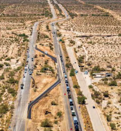 In July 2015, unexpectedly heavy rains caused a bridge
collapse near the town of Desert Center, California (010 RIV R105.045).
The bridge collapse shut down all traffic for hours on I-10 freeway
between Los Angeles and Phoenix. The EB bridge collapsed, and the WB
roadway was intact but extremely undermined by flooding and could need
just-as-extensive rebuilding. A few days later a temporary solution was
developed to avoid the circuitous hundred-mile detour: running both
directions over the undermined bridge. However, the structure was
insuffient to support the trucking traffic, and trucks were still subject
to multi-hour delays.
In July 2015, unexpectedly heavy rains caused a bridge
collapse near the town of Desert Center, California (010 RIV R105.045).
The bridge collapse shut down all traffic for hours on I-10 freeway
between Los Angeles and Phoenix. The EB bridge collapsed, and the WB
roadway was intact but extremely undermined by flooding and could need
just-as-extensive rebuilding. A few days later a temporary solution was
developed to avoid the circuitous hundred-mile detour: running both
directions over the undermined bridge. However, the structure was
insuffient to support the trucking traffic, and trucks were still subject
to multi-hour delays.
(Source: Boing Boing, 7/20/2015)
In April 2016, it was reported that a study by UC
Berkeley of the I-10 bridge collapse near Desert Center has won a
“best paper” award from an international engineering
conference, lending credence to the claim that the bridge was felled by
poor design, not an unstoppable flood. The study by engineers at UC
Berkeley argues that the Tex Wash Bridge could have survived last summer's
flood if the structure had not compressed and twisted the flow of the
water, magnifying the pressure against the bridge foundation. The study
was the basis for a special Desert Sun project – Doomed to Fail: The
fatal flaws of the Tex Wash Bridge – published in January. Caltrans
had no comment on the study. Although the flooding was epic, the paper
argues that the Tex Wash Bridge could have survived if it had been built
differently. It says that construction crews reshaped the wash when the
bridge was built in 1967, squeezing a wide river delta into a narrow
channel and forcing the flood path into a curve, which eroded the eastern
base of the bridge.
(Source: Desert Sun, 4/22/2016)
In October 2015, the CTC approved the following SHOPP funding to repair the Desert Center bridge:
Granite Construction Co., based in Watsonville, was
hired as lead contractor the day after the collapse under time-saving
emergency contracting procedures. Granite was paid for time and materials
without added bonuses. Getting the westbound bridge open and demolishing
the eastbound bridge, cost $5 million. An additional $6 million was needed
to rebuild the eastbound bridge. The new bridge has a much deeper
foundation than the 1967 original. Engineers included piles 48 inches in
diameter extending 52 feet below ground for the footing. The existing
westbound bridge received two 48-inch supports extending 23 feet deep.
Engineers also redesigned the eastbound bridge to current standards, using
one span. Using Accelerated Bridge Construction methods — meaning
building many portions offsite to reduce time and minimize road closures
and traffic disruptions -- 10 girders, each weighing 55 tons, were built
offsite by Oldcastle Precast, 130 miles away in Perris, south of
Riverside. Likewise, the abutments, made up of 240 cubic yards of
concrete, were also made in Perris. Less than two months after the
collapse, I-10 was fully back in business.
(Source: Caltrans Mile Marker, 3Q16)
In March 2019, it was reported that Granate Construction Co earned a 2018
Quality in Construction (QIC) Award for excellence in construction of an
asphalt pavement along a 31.4-mile stretch of I-10 in Riverside County
near the underpopulated Desert Center region (~ 010 RIV R105.045) back in
May 2016 from the National Asphalt Pavement Association (NAPA). The I-10
pavement rehabilitation project was a collaborative effort between Granite
Construction and Caltrans District 8. The rehabbed section of I-10 covered
approximately 63 lane-miles traveling both eastbound and westbound along
the two-lane highway. In the end, the contractor laid down a grand total
of 698,348 tons of asphalt along the corridor. After the team worked to
widen some of the existing slopes, paving work began in early July 2016 on
the I-10 rehab. The corridor is a major thoroughfare for trucks and goods
moving between Los Angeles and Phoenix, and approximately 13,000 vehicles
traverse the roadway daily, 36% of which is truck traffic. As such, a
majority of the paving work was carried out during nighttime hours in
order to significantly decrease the traffic impacts to the traveling
public. One reason for the I-10 pavement rehabilitation project receiving
the NAPA QIC award was for its implementation of green/sustainable
practices and materials in asphalt paving. This included using an asphalt
mix composed of 15% reclaimed asphalt pavement (RAP), as called for by
Caltrans specs, plus 20% recycled tire rubber. The large-scale project
involved 1.6 million sq yd of asphalt cold planing. The lift specs for the
new pavement included 521,000 tons of 25-mm Superpave dense-graded hot-mix
asphalt for the base at a 0.2 ft to 0.8 ft thickness, plus 177,000 tons of
19-mm Superpave rubber gap-graded rubberized hot-mix asphalt at 0.2 ft
thickness. The paving team averaged around 3,500 tons per day on the base
mix, while the rubberized surface mix averaged closer to 2,500 tons per
day. The western end of the project on I-10 was the closest side to the
asphalt plant, roughly 35 to 40 minutes away for trucks to circle around
with new batches. On that side of the corridor, about five to six loads of
asphalt were delivered each night. On the farther end, trucks took closer
to an hour to reach the paving crews with new asphalt, bringing in around
three or four loads per night. As paving work made its way further from
the plant, the contractor would add to the number of trucks making
deliveries. Paving on I-10 was finished in September 2017. After paving
was completed, final striping and guardrail throughout the 31 miles had to
be replaced and upgraded, which occurred between September and December.
After making some requested changes from Caltrans, all work on the I-10
rehab was completed by March 2018, two months ahead of schedule. Granite
Construction was recognized with the NAPA QIC award in January 2019 for
the completion of the I-10 pavement. “NAPA is proud to recognize
I-10 in Riverside County, constructed by Granite, with a Quality in
Construction Award,” Dr. Audrey Copeland, NAPA president & CEO,
said. “After the rating of the project’s gradation, density,
AC content and air voids by an independent engineer, this project had a
very impressive overall score given its large scope of almost 700,000 tons
of asphalt paved. Further, this project utilized sustainable practices
such as reuse/recycling by reusing 78,000 tons of RAP and 35,000 tons of
recycled tire rubber.”
(Source: Roads and Bridges, 3/4/2019)
In January 2013, it was reported that Caltrans completed installation of
Changable Message Signs over I-10 just east of Blythe (~ 010 RIV R153.164)
and just east of Desert Center. Crews have also installed 61 vehicle
detection systems covering the entire roughly 133-mile stretch of freeway
between Banning and Blythe. The detection systems monitor speed and
traffic volume, processing the data and posting it on the the freeway
message signs to give motorists' real- time estimates on how long it will
take to travel a route. The total cost of the systems and signs was just
over $2.1 million. The freeway additions were made as part of the state's
obligations under the "Interstate 10 Lifeline Emergency Action Plan,"
which Riverside County is directing. The Board of Supervisors unanimously
agreed in October to partner with the state and tribal governments on
implementing the plan, inspired by a series of massive traffic jams on
I-10 that left motorists' stranded in the last several years, most
recently on Feb. 12, 2012.
(Source: Palm Desert Patch, 1/25/13)
Mesa Verde Safety Improvements (08-Riv-10, PM R134.00/R156.50)
 In October 2020, it was reported that the CTC approved
for future consideration of funding the following project for which a
Mitigated Negative Declaration (MND) has been completed: Interstate 10
(I-10) in Riverside County. Rehabilitate pavement and make safety
improvements to I-10 in Riverside County. (08-Riv-10, PM R134.00/R156.50)
(PPNO 3009K) This project is located on I-10 in Riverside County near the
City of Blythe. The Department plans to rehabilitate pavement on I-10
within the project area while improving safety and mobility for the
traveling public between post mile R134.0 and R156.5 in Riverside County.
A temporary detour route will also be constructed to maintain
two-way traffic through the project corridor during construction. The
total project area is approximately 745 acres. This project is not fully
funded and is currently programmed in the 2020 SHOPP for a total of
$19,127,000 and $236,000,000 is currently through G-13 Contingency.
Construction is estimated to begin in 2022-2023. The scope, as described
for the preferred alternative, is consistent with the project scope
programmed by the Commission in the 2020 SHOPP.
In October 2020, it was reported that the CTC approved
for future consideration of funding the following project for which a
Mitigated Negative Declaration (MND) has been completed: Interstate 10
(I-10) in Riverside County. Rehabilitate pavement and make safety
improvements to I-10 in Riverside County. (08-Riv-10, PM R134.00/R156.50)
(PPNO 3009K) This project is located on I-10 in Riverside County near the
City of Blythe. The Department plans to rehabilitate pavement on I-10
within the project area while improving safety and mobility for the
traveling public between post mile R134.0 and R156.5 in Riverside County.
A temporary detour route will also be constructed to maintain
two-way traffic through the project corridor during construction. The
total project area is approximately 745 acres. This project is not fully
funded and is currently programmed in the 2020 SHOPP for a total of
$19,127,000 and $236,000,000 is currently through G-13 Contingency.
Construction is estimated to begin in 2022-2023. The scope, as described
for the preferred alternative, is consistent with the project scope
programmed by the Commission in the 2020 SHOPP.
(Source: October 2020 CTC Agenda, Agenda Item
2.2c.(1))
In August 2022, the CTC amended the SHOPP as follows:
08-Riv-10 R134/R156.5. PPNO 08-3009K; ProjID 0816000090; EA 1C083. I-10 In
and near Blythe, from Teed Ditch Bridge to Arizona State line (PM
156.492). Cold plane mainline pavement and overlay with
concrete pavement. The shoulders and ramps will be milled and overlaid
with asphalt pavement. A two lane temporary detour will be
constructed in the median for traffic handling. Allocation Changes ($
× 1,000): Con Sup $0 ⇨ $29,000; Const Cap: $0 ⇨ $207,000;
Total $28,375 ⇨ $264,375. Concurrent CONST and CON ENG allocation
under Resolution FP-22-10; August 2022. Note: Fully program previously
unfunded phases of this G13 Contingency project.
(Source: August 2022 CTC Agenda, Agenda Item
2.1a.(1d) #23)
In August 2022, the CTC approved the following
construction phase allocation: $270,894,000. 08-Riv-10 R134.0/R156.492.
PPNO 08-3009K; ProjID 0816000090; EA 1C083. I-10 In and near Blythe, from
Teed Ditch Bridge to Arizona State line. Outcome/Output:
Rehabilitate roadway, shoulders, and ramps, and upgrade guardrail, bridge
rails, drainage facilities, and pedestrian facilities. A two lane
temporary detour will be constructed in the median for traffic
handling. This project will extend the pavement life, improve ride
quality, and improve safety. Programmed allocation: CON ENG $29,000,000;
CONST $207,000,000. CEQA - MND, 7/27/2020; Re-validation 6/27/2022.
NEPA - FONSI, 7/27/2020; Re-validation 6/27/2022. Future consideration of
funding approved under Resolution E-20-92; October 2020. As part of this
allocation request, the Department is requesting to extend the completion
of CONST and CON ENG an additional 6 months beyond the 36 month deadline.
SB 1 Baseline Agreement approval under Resolution SHOPP-P-2021-02B;
October 2020. Two month time extension for CONST and CON ENG approved
under Waiver 22-73; June 2022. EA 1C083/PPNO 08-3009K combined with Clean
California EA 1N060 for construction under EA 1C08U/Project ID 0822000142.
Concurrent Amendment under SHOPP Amendment 22H-003; August 2022.
(Source: August 2022 CTC Agenda, Agenda Item
2.5b.(1) #62)
Commuter LanesHOV lanes were planned/are constructed as follows:
HOT Lanes: Los Angeles to I-710 / El Monte Busway
HOV lanes have been constructed from Hewitt Street in downtown Los Angeles to I-710 in El Monte (10S LA 17.083 to 10S LA 21.635). This is called the "El Monte Busway". It opened in January 1973, and originally for buses only, with very limited ingress and egress.
Groundbreaking for the busway occurred on January 21, 1972. The first 8
of 11 total miles were anticipated to be open by Fall 1972. The busway ran
from Mission Blvd to a terminal at Santa Anita Avenue in El Monte. The
lanes took over former Southern Pacific Right of Way. After leaving El
Monte, buses stopped only at California State College, Los Angeles (now
CSULA) and Los Angeles County-USC Medical Center before arriving in
downtown Los Angeles. The project, made possible through federal, state
and SCRTD funding, aimed to determine the feasibility of new concepts of
joint highway-bus operations and to increase the overall people-carrying
capacity of freeway corridors with the least possible adverse impact on
communities and the environment.The busway was first conceived in 1969 and
was California’s first example of a multi-modal transportation
system at a cost of $53 million. At the El Monte end of the line, a new
$945,000 terminal was planned. The station’s opening was scheduled
to coincide with that of the busway, but was not dedicated until July,
1973. In 1976, the busway was opened up to three-person carpools to
further reduce congestion on the freeway. However, a brief experiment with
two-person carpools in 2000 was soon cancelled after speeds on the busway
plunged from 65 mph to 20mph and travel times increased by 20-30 minutes.
(Source: Metro Primary Resources, 1/23/2012)
The carpool lanes of the El Monte Busway can only be entered and exited
at a few points. The segment from El Monte to I-710 is demarcated not only
with two 'double yellow' lines which are typical of Southern California
HOV lanes, but also an approximately 12-foot-wide (3.7 m) asphalt median.
The segment west of I-710 into Downtown Los Angeles is on an alignment
separate from the regular lanes of the I-10 As part of the ExpressLanes
project, this buffer zone was restriped into a travel lane. Westbound
entrances are at I-605, Baldwin Ave. in El Monte, El Monte Bus Station
(for buses only), Del Mar Ave. (where motorists take a ramp from street
level), and I-710 (for buses only). Westbound exits are at Baldwin Ave.,
Fremont Ave., I-710, I-5, Vignes St., and Alameda St. Eastbound entrances
are at Alameda St., Patsaouras Transit Plaza at Union Station, I-710, and
Baldwin Ave. Eastbound exits are at Patsaouras Transit Plaza, I-710 (for
buses only), Del Mar Ave. (where motorists take a ramp to street level),
Baldwin Ave., and I-605.
(Source: Wikipedia)
The busway is in operation 24 hours a day. In April 2008, the federal government offered Los Angeles County $213 million to convert these lanes to special, congestion-pricing toll lanes. In the proposed deal, the federal money would go toward the purchase of about 60 high-volume buses that would use the new toll lanes. That would free up MTA funds for creating the toll lanes. CTC approval would be required. The busway was upgraded from high-occupancy vehicle (HOV) lanes to high-occupancy toll (HOT) lanes as part of the Metro ExpressLanes project in February 2013 (see below).
Due to its history and grade separation, as well as the fact that it continues W beyond the end of this segment of I-10 along US 101 to Union Station, the Busway is technically I-10S.
In June 2009, it was reported that Los Angeles County transportation officials were considering charging solo motorists 25 cents to $1.40 a mile to use the high occupancy toll lanes proposed for the Harbor and San Bernardino freeways. Officials plan to use congestion-based pricing, which means that tolls will rise and fall in direct relation with the flow of traffic — a formula designed to keep individual motorists, carpools, van pools and buses in the high occupancy lanes at a minimum of 45 mph, even during rush hour. Under the proposed pricing schedule, 25 cents a mile would be charged when demand is lowest for the lanes, while the maximum, $1.40 a mile, would be the toll during the busiest part of the day. Before the toll schedule is finalized in late July 2009, the public will be allowed to comment on the prices at five community hearings this month in Los Angeles, Torrance, Carson, El Monte and West Covina. The yearlong demonstration project has received $210.6 million in federal funds to help reduce traffic and improve bus service along the two freeways -- the largest congestion-easing grant awarded to any city to date, according to the U.S. Department of Transportation. Caltrans and the MTA will use the money to convert existing carpool lanes to high-occupancy toll lanes on 14 miles of the San Bernardino Freeway from Alameda Street to the 605 Freeway interchange and on 11 miles of the Harbor Freeway from Adams Boulevard to the Artesia Transit Center at 182nd Street. A second high-occupancy toll lane will be added in both directions to the San Bernardino Freeway. The project also calls for automated toll plazas, road improvements and additional transit services, including 57 clean-fuel buses for both freeway corridors. The entire project is expected to be completed by December 2010.
In September 2010, the CTC approved for future consideration of funding a project in Los Angeles County will convert High Occupancy Vehicle lanes to High Occupancy Toll lanes. The project was covered environmentally with two separate environmental documents, one document for the Route 110 and Route 105 portion of the project and one document for the Route 10 and Route 10S portion of the project (Route 10S is the El Monte Busway). The project is programmed in the State-Local Partnership Program and includes federal and local funds. Construction is estimated to begin in Fiscal Year 2010-11. Total estimated project cost is $69,300,000 for capital and support. The project will not involve a substantial amount of construction activities but due to public interest and controversy associated with toll lanes and the large amount of public outreach and education involved with the project it was decided to prepare a higher level of environmental document.
The specific plan is to convert the HOV lanes on the 14-mile stretch of the I-10 between Alameda Street and the I-605 for a one-year pilot project. In March 2011, it was reported that the HOT lanes are expected to be complete in 2012. They will allow solitary drivers to enjoy the perks of car-pool lanes by paying a minimum of 25 cents per mile and a maximum $1.40 per mile. Tolls will be adjusted according to traffic conditions to maintain a free-flowing level of traffic. Buses, motorcycles, vanpools and carpools that currently use the car-pool lanes will not be charged a toll. General purpose lanes will continue to remain toll-free. Construction for the project, which is funded with a $210 million grant from the U.S. Department of Transportation, will begin in summer 2011.
In July 2011, ground was officially broken on the ExpressLanes project that will convert existing carpool (HOV) lanes along the Harbor Freeway (I-110) and the San Bernardino Freeway (I-10) to High-Occupancy Toll (HOT) lanes. The one-year demonstration program will covert 11 miles of existing carpool lanes on the I-110 (Harbor Freeway Transitway) between the Artesia Transit Center/182nd Street and Adams Boulevard near downtown Los Angeles and 14 miles on the I-10 (El Monte Busway) between Union Station/Alameda Street and the I-605 to toll lanes. During the construction phase of the program, workers will be installing a host of power and utility support units needed for the operation of 27 dynamic message signs (DMS) along the two freeway corridors as well as the installation of 22 toll transponder readers and approximately 145 signs to provide commuters information on the ExpressLanes and the tolls being charged to use the lanes. In addition, along the I-10 (San Bernardino Freeway) an additional toll lane will be constructed in each direction between the I-605 and the I-710 freeways to add capacity along that heavily traveled corridor. Currently, there is only one carpool lane operating in each direction along the El Monte Busway. None of the general purpose lanes will be taken away to covert the lanes and make the improvements. Construction crews also will widen Adams Boulevard off-ramp, add a right turn lane on Adams Boulevard, construct a pedestrian bridge, and re-stripe Figueroa Way in Los Angeles in support of the ExpressLanes project.
Portions of I-10 are being converted to have HOT (High Occupancy/Toll) lanes--specifically, the I-10 El Monte Busway HOV lanes (I-605 to Alameda St). In June 2012, it was reported that drivers (even HOV drivers) will require a transponder for those routes. The so-called “suggestion pricing” ranges between a minimum toll per mile of $0.25 and a maximum of $1.40 and will debut first in on I-110 in November, followed by I-10 early in 2013. Caltrans said the toll prices will fluctuate according to traffic levels in the carpool lane. Information on the project and the transponders can be found at the Metro ExpressLanes website.
The HOT lanes on I-10 opened for traffic on 2/23/13. Fastrak transponders are required. Fees for noncarpoolers will be assessed between 25 cents and $1.40 a mile, depending on the volume of traffic, according to Metro. The average toll is expected to be around $6, Metro said. Motorists riding the regular lanes are not charged.
In June 2014, LA Metro voted to make the HOT lanes permanent (they had previously been a demonstration project). The agency expected to distribute 100,000 of the transponders required to use the lanes, but ended up handing out more than 260,000.
In September 2016, the legislature passed a bill requiring LACMTA to take additional steps, beyond the previous implementation of a low-income assistance program, to increase enrollment and participation in the low-income assistance program, as specified, through advertising and work with community organizations and social service agencies. The bill would also require LACMTA and the Department of Transportation to report to the Legislature by December 31, 2018, on efforts to improve the HOT lane program, including efforts to increase participation in the low-income assistance program. (AB 620, Chapter 738, Statutes of 2016, 9/28/2016)
2007 CMIA. A number of projects on I-10 in Los Angeles County were submitted to the Corridor Mobility Improvement Account for funding. These projects included HOV lanes, Puente Ave. (~ 010LA 33.342) to Citrus St. ($173 million) (~ 010 LA 37.492); HOV lanes, Citrus St. (~ 010 LA 37.492) to Route 57 ($191.5 million) (~ 010 LA 42.368) ; and the I-10/I-605 transition connector ($70.5 million) (~ 010 LA 31.078). In San Bernardino County, a request for bridge widenings in preparation for HOV lanes ($107,931K) was also non-recommended. None were recommended for funding. This has been a point of contention in the inland empire as there is significant congestion on the I-10.
In his 2006 Strategic Growth Plan, Governor Schwartzenegger proposed constructing HOV lanes from Puente to Route 57 in LA County.
![[TCRP Project 40]](maps/010-tcrp-40.jpg) In April 2006, it was noted that
Segments (3) [I-605 to Puente Avenue], (4) [Puente Ave to Citrus Ave], and
(5) [Citrus Ave to Route 57 (nee Route 210)] above are the subject of
District 7 TCRP Project #40, which plans to add HOV lanes to this segment,
for a total cost of $210 million. The estimated completion date is 1Q2008
for the segment from I-605 to Puente Ave, 1Q2010 for the segment from
Puente to Citrus, and 1Q2012 for the segment from Citrus to Route 57. A
negative EIR (a good thing) came back in February 2004. However, due to
funding, the schedule has been pushed back. In April 2006, the CTC
considered requests approval of a TCRP project application amendment for
$56,900,000 in new TCRP funding that would program $56,900,000 in TCRP
funds to Construction; redistribute $4,194,000 from Plans, Specifications,
and Estimates (PS&E) to Construction; redistribute $757,000 from Right
of Way to Construction; and update the project funding plan. The project
will provide for approximately 11.2 miles of HOV lanes that will
effectively double the people carrying capacity of a mixed flow lane thus
alleviating some of the congestion by encouraging and supporting the use
of shared ride modes. The project will be delivered in three segments,
with Segment 1 (Route 605 to Puente Avenue) fully funded with TCRP,
STIP-RIP, and Proposition C funds. The current schedule is: Phase 1: FY
2002/2003; Phase 2: FY 2010/2011; Phase 3: FY 2010/2011; Phase 4: FY
2013/2014. Some of these were submitted for funding from the 2007 CMIA
allocations, but none were recommended for approval. In April 2008,
CalTrans and LACMTA requested amending TCRP Project #40 to designate
LACMTA as a co-applicant agency, to update the project schedule and
funding plan, as well as approval of an Assembly Bill (AB) 1335 LONP to
use $61,851,000 in Congestion Mitigation and Air Quality (CMAQ) funds in
lieu of TCRP funds for the Construction phase of this project. The amended
schedule shows completion of phases 3 and 4 in FY 2011/2012.
In April 2006, it was noted that
Segments (3) [I-605 to Puente Avenue], (4) [Puente Ave to Citrus Ave], and
(5) [Citrus Ave to Route 57 (nee Route 210)] above are the subject of
District 7 TCRP Project #40, which plans to add HOV lanes to this segment,
for a total cost of $210 million. The estimated completion date is 1Q2008
for the segment from I-605 to Puente Ave, 1Q2010 for the segment from
Puente to Citrus, and 1Q2012 for the segment from Citrus to Route 57. A
negative EIR (a good thing) came back in February 2004. However, due to
funding, the schedule has been pushed back. In April 2006, the CTC
considered requests approval of a TCRP project application amendment for
$56,900,000 in new TCRP funding that would program $56,900,000 in TCRP
funds to Construction; redistribute $4,194,000 from Plans, Specifications,
and Estimates (PS&E) to Construction; redistribute $757,000 from Right
of Way to Construction; and update the project funding plan. The project
will provide for approximately 11.2 miles of HOV lanes that will
effectively double the people carrying capacity of a mixed flow lane thus
alleviating some of the congestion by encouraging and supporting the use
of shared ride modes. The project will be delivered in three segments,
with Segment 1 (Route 605 to Puente Avenue) fully funded with TCRP,
STIP-RIP, and Proposition C funds. The current schedule is: Phase 1: FY
2002/2003; Phase 2: FY 2010/2011; Phase 3: FY 2010/2011; Phase 4: FY
2013/2014. Some of these were submitted for funding from the 2007 CMIA
allocations, but none were recommended for approval. In April 2008,
CalTrans and LACMTA requested amending TCRP Project #40 to designate
LACMTA as a co-applicant agency, to update the project schedule and
funding plan, as well as approval of an Assembly Bill (AB) 1335 LONP to
use $61,851,000 in Congestion Mitigation and Air Quality (CMAQ) funds in
lieu of TCRP funds for the Construction phase of this project. The amended
schedule shows completion of phases 3 and 4 in FY 2011/2012.
As of late 2007, there were some proposals to convert some future lanes E of I-605 into High-Occupancy Toll (HOT) lanes.
In November 2010, the CTC approved transfer of CMIA funds allocated to the I-405 HOV project that were replaced with ARRA funds to be used for the Citrus St. to Route 57 HOV lanes.
In January 2011, it was reported that land was being acquired in West Covina for the widening of the route for these lanes. This included some property at the West Covina Mall.
In June 2011, it was reported that Caltrans completed the reconstruction of the Baldwin Park Boulevard Bridge in order to accommodate new carpool lanes that are being built on I-10. This is part of a project that is adding two miles of carpool lanes, east and west, on a portion of the I-10 freeway from the San Gabriel Valley Freeway (I-605) to Puente Avenue. Metro programmed $6.3 million to fund the reconstruction of the bridge, a component of the $169 million HOV lane project.
In August 2012, the CTC accepted the environmental document, and Findings of Fact, and approved for future consideration of funding, a project that will add one High Occupancy Vehicle (HOV) lane in each direction on I-10 from Puente Avenue to Route 57 in Los Angeles County. The overall project is being constructed as two smaller projects on adjoining segments of I-10. The I-10 HOV Lanes from Puente Avenue to Citrus Street project (PPNO 0309N) will construct HOV lanes from Post Mile (PM) 33.2 to PM 37.2. The total estimated cost is $137,657,000 for capital and support. Construction is estimated to begin in Fiscal Year (FY) 2012-13. The I-10 HOV Lanes from Citrus Street to SR-57 project (PPNO 0310B) will construct HOV lanes from PM 37.5 to PM 42.4. The total estimated cost is $234,861,000 for capital and support. Construction is estimated to begin in FY 2013-14. Both projects are programmed in the 2012 State Transportation Improvement Program (STIP). The scope of the overall I-10 HOV Lane Project, as described for the preferred alternative, is consistent with the project scope programmed in the 2012 STIP. Note: This is roughly Segments 2 and 3 in the map above.
In August 2012, the CTC approved $10.3 million to fund the ongoing extension of a carpool lane on I-10 from I-605 to Route 57 through Baldwin Park, West Covina and Pomona. The extra allocation will help pay for the project's second phase, a $184 million extension of the carpool lanes from Puente Avenue in Baldwin Park to Citrus Avenue in West Covina. Construction on the second phase of the project should begin in the spring of 2013. The first phase of the carpool lane project is being constructed from the El Monte busway to about Puente Avenue in Baldwin Park. A third phase will take the carpool lane over Kellogg Hill, from Citrus Avenue to Route 57. That will cost about $192 million.
In December 2013, Caltrans officially dedicated 2.2 miles of HOV lanes in both directions on I-10 between I-605 and Puente Avenue in Baldwin Park.
In April 2015, it was reported that Caltrans officials broke ground on a
construction project that will add 5.2 miles of carpool lanes in each
direction of the San Bernardino (10) Freeway between West Covina (Citrus
St.) and Pomona (Route 57). The project will also include the construction
of soundwalls to reduce freeway noise in adjacent neighborhoods.
Construction is expected to be completed by summer 2021.
(Source: Baldwin Park Patch, 4/29/2016)
In May 2015, the CTC allocated $17,715,000 towards the Route 10 HOV Lanes from Citrus Street to Route 57. This is on top of $154,720,000 from other sources.
In June 2017, the CTC was informed that the authorized amount for TCRP Project 40 is $90 million, of which $28,149,000 was previously programmed and allocated. In April 2008, the Commission approved a Letter of No Prejudice for the remaining amount of $61,851,000, allowing the Department to spend Metro’s Congestion Mitigation and Air Quality Improvement Program funding for construction, with reimbursement of TCRP funds to Metro in the future. In September 2008, the Commission approved the TCRP Allocation Plan, placing this project on the Tier 1 list with a future payback to Metro in the amount of $61,851,000. Due to substantial savings at award of the contract, project expenditures amounted to approximately $41,233,000, leaving $20,618,000 in TCRP Tier 1 savings. The project is now substantially complete. The Department and Metro propose to amend Project 40 to de-program the $20,618,000 in TCRP project savings and update the project funding plan, and to transfer those funds to fund TCRP Project 38.2, Los Angeles -San Fernando Valley Transit Extension and TCRP 50, Route 71.
In November 2017, it was reported that construction is ongoing for the
second and third segments of the original three segments (I-605 to Puente
was completed in 2013). Work on the second segment, which is from Puente
Avenue in Baldwin Park to Citrus Street in West Covina, started in summer
2014, and is expected to be completed by Dec. 2018, months ahead of
schedule. The final segment is from Citrus Street in Covina/West Covina to
State Route 57, and once completed in summer 2021, will provide one
continuous HOV lane in both directions of I-10 from Interstate 15 in San
Bernardino County to downtown Los Angeles.
(Source: District 7 Blog, 11/28/2017)
In July 2019, the LA Metro board approved reallocation of $10,910,051 in
Congestion Mitigation and Air Quality Improvement Program (CMAQ) Funds
savings in the I-10 High Occupancy Vehicle (HOV) Lanes Project from I-605
to Puente Avenue (Segment 1) to be programmed to pay for the cost increase
in the I-10 HOV Lanes Project from Puente Avenue to Citrus Avenue (Segment
2); and also approved an additional $836,000 in CMAQ Funds for the cost
increase in Segment 2.
(Source: Metro Board Recap, 7/25/2019)
HOT Lanes: I-605 to SBD County Line
 In April 2022, it was reported that Caltrans and Metro are beginning the environmental project
and evaluating alternatives to convert existing high-occupancy vehicle
(HOV) lanes to dynamically priced, high-occupancy toll (HOT) lanes, also
called ExpressLanes, or add a second HOV lane in both directions on I-10
from the current ExpressLanes end point at I-605 to the Los Angeles/San
Bernardino County line. The I-10 ExpressLanes Extension Project will
analyze four proposed alternatives:
In April 2022, it was reported that Caltrans and Metro are beginning the environmental project
and evaluating alternatives to convert existing high-occupancy vehicle
(HOV) lanes to dynamically priced, high-occupancy toll (HOT) lanes, also
called ExpressLanes, or add a second HOV lane in both directions on I-10
from the current ExpressLanes end point at I-605 to the Los Angeles/San
Bernardino County line. The I-10 ExpressLanes Extension Project will
analyze four proposed alternatives:
(Source: Metro Project Page, 5/5/2022)
HOV/HOT Lanes: Route 57 to Redlands (07-LA-10, 44.9/48.3, 08-SBd-10, PM 0.0/R37.0)
In April 2012, the CTC authorized $1,000,000 for the locally administered State Transportation Improvement Program (STIP) I-10 HOV Lane Extension (PPNO 0134K) project, plus $10,560,000 from other sources. The funding is to complete planning and engineering activities. The project will add an HOV lane from Haven Avenue to Ford Street in Ontario and Redlands.
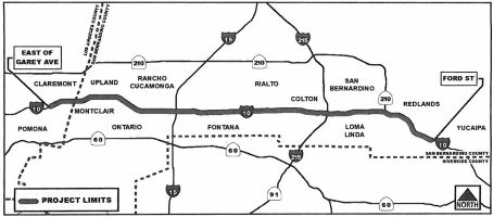 In March 2013, the CTC received notice of the preparation of
an EIR for a project that would improve and widen a 24-mile segment of
I-10 from two miles west of the Los Angeles/San Bernardino County Line in
the city of Pomona to Ford Street in the city of Redlands. The project is
programmed in the 2012 State Transportation Improvement Program. The total
estimated cost is $539,817,000. Construction is estimated to begin in
Fiscal Year 2019-20. Three alternatives are being considered: (1)
No-build; (2) One High Occupancy Vehicle Lane in each direction; (3) Two
Express Lanes in each direction.
In March 2013, the CTC received notice of the preparation of
an EIR for a project that would improve and widen a 24-mile segment of
I-10 from two miles west of the Los Angeles/San Bernardino County Line in
the city of Pomona to Ford Street in the city of Redlands. The project is
programmed in the 2012 State Transportation Improvement Program. The total
estimated cost is $539,817,000. Construction is estimated to begin in
Fiscal Year 2019-20. Three alternatives are being considered: (1)
No-build; (2) One High Occupancy Vehicle Lane in each direction; (3) Two
Express Lanes in each direction.
In April 2017, it was reported that after years of
study, the San Bernardino planning agency is getting ready to complete
plans for 33 miles of toll lanes. The $1.4 billion project would add two
toll lanes and one general lane from the Los Angeles County line in Upland
east to Redlands. It will be the first use of tolls in San Bernardino
County. The route is one of the region’s most widely used, with
about 263,000 vehicles and more than 20,000 commercial trucks a day, the
agency reports. By 2045, the number of vehicles is expected to grow to
350,000 a day. The agency – formerly called the San Bernardino
Associated Governments – is completing an environmental study for
the project and hopes to get approval from Caltrans in summer. The agency
expects to hire a firm by mid-2018 that will handle design and
construction of the project, said Paula Beauchamp, project delivery
director for the authority. It also hopes to have an agreement with a toll
service company to oversee the lanes by then. Construction would be split
into two stages, the first beginning in late 2018 that would cover a
10-mile section from the Los Angeles County line to I-15 and be completed
in 2022, Beauchamp said. Crews would then move to the remaining section,
from I-15 to Redlands. Construction on this stretch would continue through
2026. Officials are considering three options: no improvements, adding a
carpool lane or adding toll lanes. The carpool lane option would extend an
existing one that now ends at Haven Avenue in Ontario and take it to Ford
Street in eastern Redlands – about 25 miles. A toll lanes project
would feature two toll lanes plus one general purpose lane over 33 miles
and across 13 cities. The board still must vote on its choice, but agency
officials suggest the toll lanes. That choice would increase freeway lanes
by 50 percent and free up traffic on general lanes as well.
(Source: Press-Enterprise, 4/19/2017)
In July 2017, it was reported that San Bernardino
County will make its first foray into toll lanes. A 33-mile corridor will
be built on I-10 and span much of the county, transportation officials
decided Wednesday, July 12. The $1.8-billion project would add two toll
lanes from the Los Angeles County line near Montclair east to Redlands. An
auxiliary lane for traffic to weave in and out at ramps also will be added
at various points along the general-purpose lanes. Construction, which
would be split into two stages, is expected to start in late 2018. The
first segment, from the county line to I-15, is expected to be finished by
2022. The rest would begin in 2021 and take three years to complete.
Transportation officials say the project will bring a faster alternative
for commuters who choose to pay the new tolls. And, by diverting that
traffic onto two new lanes, it would also ease congestion on the general
lanes, said Ontario Councilman Alan Wapner, president of the
transportation board. The agency’s next steps will be to begin
buying property along the freeway needed for its widening and to choose a
contractor to handle final design and construction. The agency expects to
rebuild or modify several ramps, bridges and interchanges along the route.
The project encompasses I-10 from the Monte Vista Avenue exit in Montclair
to Ford Street in Redlands. A small portion — from California Street
to Ford Street in Redlands — would only have one toll lane in each
direction, though the majority of the project would have two.
(Source: Press Enterprise, 7/12/2017)
In October 2017, the CTC approved for future
consideration of funding the following project for which a Final
Environmental Impact Report (FEIR) has been completed: I-10 in San
Bernardino and Los Angeles Counties. Construct roadway improvements
including additional lanes on a portion of I-10 in and near the city of
Redlands. (07-LA-10, 44.9/48.3, 08-SBd-10, PM 0.0/R37.0) (PPNO 0134K).
This project in San Bernardino and Los Angeles Counties will construct one
to two express lanes along I-10 from the Los Angeles/San Bernardino County
line to Ford Street in the city of Redlands. The project is not fully
funded. The estimated project cost is $1.7 to $1.9 billion. Funding is
anticipated from local measure funds, the Congestion Mitigation and Air
Quality program, and State and Federal funds. The project is programmed in
the 2017 Federal Transportation Improvement Plan and 2016 State
Transportation Improvement Plan (STIP). Construction is estimated to begin
in 2018. The scope, as described for the preferred alternative, is
consistent with the project scope programmed by the Commission in the 2016
STIP.
(Source: CTC October 2017 Agenda Item 2.2c.(2))
The 2018 STIP, approved at the CTC March 2018 meeting, appears to close out PPNO 0134K, transferring the remaining $39.745M to PPNO 3009P Rt 10 Express Lanes, San Antonio Av-Rt 15 (~ SBD 2.917 to SBD 9.828), Contract 1 (D/B). It also allocated $112.019M for PPNO 3010N Rt 10 Express Lanes, Rt 15-Ford St (~ SBD 9.828 to SBD 33.139), Contract 2 (D/B)
In June 2018, the CTC approved amending the Trade
Corridors Improvement Fund Program to add the I-10 Corridor Express Lanes
Contract 1 Project, from the White Avenue overcrossing to the Los
Angeles/San Bernardino County line in Los Angeles County, and from the Los
Angeles/San Bernardino County line to the I-15 interchange in San
Bernardino County, as Trade Corridors Improvement Fund Project 128 at a
cost of $4,973,000 to the Trade Corridors Improvement Fund. The proposed
multi-funded project will widen the I-10 freeway to allow the construction
of two express lanes in each direction. Auxiliary lanes will also be added
at strategic locations. The express lanes would be managed through
congestion pricing to maintain free flow conditions in the lanes during
peak travel times. The complete I-10 Corridor Project extends 33 miles and
entails construction of two tolled express lanes in each direction, plus
auxiliary lanes where warranted, between the Los Angeles County line and
Route 210, including a transition to a single tolled express lane in each
direction from Route 210 to Ford Street in the City of Redlands. The
complete I-10 Corridor Project, including both Contract 1 and 2, is
estimated at $1.8 billion.
(Source: CTC Agenda, June 2018 Agenda Item 4.9 and AgendaItem
4.10)
In February 2020, it was reported that the first of
three phases of the $929.9 million project I-10 Corridor Project, also
known as toll lanes project, is expected to begin in spring 2020. The
project will provide approximately 33 miles of Express Lanes in San
Bernardino County from the Los Angeles County line to Ford Street in
Redlands. Phase one will add 10 miles of Express Lanes from the Los
Angeles County line to I-15. The project will have two toll express lanes
in each direction. Lanes to assist drivers getting on and off the freeway
will be constructed in selected locations. Estimated completion of the
project, funded in part by Measure I, is spring of 2023. Toll pricing will
vary based on demand and distance. Exact pricing will be determined when
the Express Lanes open and will be advertised at each point of entry
within the corridor. Vehicles with a Clean Air Vehicle decal can use
Express Lanes with exceptions. The High Occupancy Vehicle of three
passengers or more can use the toll roads free of charge. Those vehicles
with less than three passengers will be charged.
(Source: Highland News, 2/20/2020)
The 2020 STIP, approved at the March 2020 CTC meeting,
deleted the programmed funding for PPNO 3010N "Rt 10 Express Lanes, Rt
15-Ford St, Contract 2 (D/B)", but appeared to divide them into two
projects: PPNO 3016P "Rt 10 Express Lanes, Rt 15-Sierra Av, Contract 2A
(D/B)" (with 22,065K allocated in FY24-25) and PPNO 0167M "Rt 15 Express
Lanes, Cantu Galeano-Foothill, Contract 1 (SB1)" (with 72,274K allocated
in FY22-23).
(Source: March 2020 CTC Agenda, Item 4.7, 2020 STIP
Adopted 3/25/2020)
On March 16, 2022, the CTC approved the 2022 State
Transportation Improvement Program, which included the following project:
PPNO 3019L "Rt 10 Express Lanes, Rt 15-Pepper Av, Contract 2 (SB1)"
54,242,000 in FY 25-26 and $11,949,000 in FY22-23.
(Source: "2022 State Transportation Improvement
Program", Adopted March 16, 2022)
In May 2022, the CTC approved an advance programming
request from the San Bernardino County Transportation Authority of
$85,000,000 for the construction of the I-10 Corridor Freight and Managed
Lane Project. This project demonstrates a significant freight benefit and
would contribute funding to a zero-emission truck program is revenue is
collected in excess of funding needed for operations and maintenance. This
project is located along a section of I-10 that has been designated the
ninth most critical truck bottleneck in the United States by the American
Transportation Research Institute. It is also one of the largest logistics
hubs in the country, with over 200 million square feet of distribution
facilities within a five-mile radius of the project. The project would
improve the reliability of a segment that carries over 25,000 trucks per
day,15,000 of which are 5+ axle trucks. This segment of the I-10 highway
corridor also supports the intermodal transfer of containers from truck to
train and train to truck. The San Bernardino County Transportation
Authority board adopted a toll revenue policy along this route that allows
for toll revenues received as a result of the project to go towards a
clean- truck incentive funding program. The project will construct three
eastbound auxiliary lanes and one westbound auxiliary lane to improve
truck operations and safety. It will construct one high occupancy toll
lane in each direction in the median of I-10, connecting with the high
occupancy toll lanes currently under construction on I-10 west of I-15.
The I-15/I-10 interchange is ranked the 9th most critical truck
bottleneck in the United States by the American Transportation Research
Institute. Queues of trucks and other traffic regularly extend from
eastbound interchanges to the I-15/I-10 interchange during evening
traffic. The project supports a new opportunity to incentivize transit,
shared-ride vehicles, and zero-emission vehicles. The project also
includes authorization by San Bernardino County Transportation Authority
board to invest a share of excess toll revenue for clean truck funding
incentives in disadvantaged communities.
(Source: May 2022 CTC Agenda, Agenda Item 4.14)
In June 2022, an update was provided on the San
Bernardino portion of this construction. Phase 1 of the San Bernardino
County Transportation Authority's (SBCTA) $929.2 million Interstate 10
Corridor Project began in September 2018 and is expected to be completed
in early 2024. The work is being conducted by a joint-venture that brings
together the Lane Construction Corporation and Security Paving Company
Inc. SBCTA's Interstate 10 Corridor Project is comprised of three phases
of improvements. The first phase, stretching 10 mi. from the Los Angeles
County line to I-15, was under construction as of June 2022. The second
phase, stretching 11.1 mi. from I-15 to Pepper Avenue in Colton, is in
design and the final funding components are being sought to enable
construction to begin in 2024. The third and final future phase of 12 mi.
will be from Pepper Avenue to Ford Street in Redlands. Phase 1, a
design-build contract, has a single new lane being constructed and is
being combined with the existing HOV lane to provide two tolled express
lanes in each direction. Lanes to assist drivers getting on and off the
freeway (auxiliary lanes) are being constructed in selected locations, and
18 bridges throughout the corridor will either be replaced, widened or
improved to accommodate the widening of the freeway. In Phase 2, a single
toll express lanes will be constructed where there are currently no HOV
lanes. The work is immense and crews are constructing 11 mi. of two
express lanes in each direction of I-10 from the Los Angeles/San
Bernardino County line to east of the I-10/I-15 interchange. As far as the
18 bridges, crews are replacing eight, widening eight and improving two.
Partial pavement rehabilitation is also being done. This is requiring
7,861 tons of rebar steel and 670,000 tons of concrete. A further
breakdown reveals 285,000 cu. yds. of PCCP concrete, 100,000 cu. yds. of
structural concrete, along with 78,601 linear ft. of new drainage systems
to be installed. Crews also are excavating and removing 2,177,450 tons of
earth. So far, the project has completed the following: Sultana Avenue
Overpass, two Holt Boulevard underpass widenings, the Day Canyon Channel,
multiple other bridge phases, multiple walls, ramp reconfigurations and
I-10 pavement replacement/widenings all throughout the corridor.
(Source: Construction Equipment Guide, 6/28/2022)
 Business Routes Naming
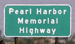 The portion of I-10 located in California is designated
the "Pearl Harbor Memorial Highway". This segment was named in
remembrance of approximately 2000 brave and patriotic survivors of the
attack on Pearl Harbor. On December 7, 1941, just before 8 a.m. on a
Sunday morning, the first wave of bombers began the attack on Pearl Harbor
that led the United States into World War II. It was an unforgettable day
for those who lived through it and one that called America forth to defend
itself. In so doing, it inspired a generation of Americans to rise and
lead the defense of freedom around the world. Overall, on December 7th,
1941, 2,335 people were killed in action and 1,178 were wounded; the
majority of the Pacific Fleet that was damaged and sunk in the attack was
at one time home ported in California. Named by Senate Concurrent
Resolution (SCR) 8, Resolution Chapter 72, on 7/12/2005.
The portion of I-10 located in California is designated
the "Pearl Harbor Memorial Highway". This segment was named in
remembrance of approximately 2000 brave and patriotic survivors of the
attack on Pearl Harbor. On December 7, 1941, just before 8 a.m. on a
Sunday morning, the first wave of bombers began the attack on Pearl Harbor
that led the United States into World War II. It was an unforgettable day
for those who lived through it and one that called America forth to defend
itself. In so doing, it inspired a generation of Americans to rise and
lead the defense of freedom around the world. Overall, on December 7th,
1941, 2,335 people were killed in action and 1,178 were wounded; the
majority of the Pacific Fleet that was damaged and sunk in the attack was
at one time home ported in California. Named by Senate Concurrent
Resolution (SCR) 8, Resolution Chapter 72, on 7/12/2005.
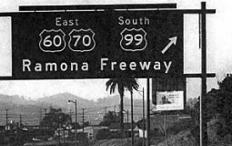 Originally, the segment that opened in 1943 (from US 101 to Route 215, originally signed
as US 60 / US 70 / US 99) was named the "Ramona Freeway". Ramona
was the central character in the Helen Hunt Jackson novel Ramona, which was a seminal novel in the early 20th century in creating
the romance of California.
Originally, the segment that opened in 1943 (from US 101 to Route 215, originally signed
as US 60 / US 70 / US 99) was named the "Ramona Freeway". Ramona
was the central character in the Helen Hunt Jackson novel Ramona, which was a seminal novel in the early 20th century in creating
the romance of California.
(Image source: Forgotten Highway)
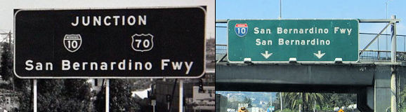 The portion of this freeway from US 101 to Route 215 (~ LA
S0.094 to SBD R24.146) is named the "San Bernardino Freeway";
the first segment opened in 1943 and the last segment in 1957. It was
named by the State Highway Commission, based on its primary destination of
San Bernardino. San Bernardino was first recorded as a place name in 1810,
and derives from the name of the Italian saint of the 15th
century. In 1842 it was applied to a land grant, on a part of which
Mormons in 1851 started a settlement, the nucleus for the present city.
The mountains are mentioned before 1850, the county was named in 1853, and
the national forest in 1893. The name "San Bernardino Freeway" was
bestowed on November 24, 1954, just eight days after the opening
ceremonies. Originally called the Ramona Freeway, Pomona interests had
pushed for the route to be named for their city, which it bisected.
Instead, the State Highway Commission announced the route would be known
as the San Bernardino Freeway, even though the completed freeway wouldn't
even go to downtown San Bernardino, unless you made a left turn on US 395
(now Route 15) just east of Colton. They suggested that the future
"foothills" route (I-210 Freeway) would be better named for San
Bernardino.
The portion of this freeway from US 101 to Route 215 (~ LA
S0.094 to SBD R24.146) is named the "San Bernardino Freeway";
the first segment opened in 1943 and the last segment in 1957. It was
named by the State Highway Commission, based on its primary destination of
San Bernardino. San Bernardino was first recorded as a place name in 1810,
and derives from the name of the Italian saint of the 15th
century. In 1842 it was applied to a land grant, on a part of which
Mormons in 1851 started a settlement, the nucleus for the present city.
The mountains are mentioned before 1850, the county was named in 1853, and
the national forest in 1893. The name "San Bernardino Freeway" was
bestowed on November 24, 1954, just eight days after the opening
ceremonies. Originally called the Ramona Freeway, Pomona interests had
pushed for the route to be named for their city, which it bisected.
Instead, the State Highway Commission announced the route would be known
as the San Bernardino Freeway, even though the completed freeway wouldn't
even go to downtown San Bernardino, unless you made a left turn on US 395
(now Route 15) just east of Colton. They suggested that the future
"foothills" route (I-210 Freeway) would be better named for San
Bernardino.
(Image source:Facebook; AARoads)
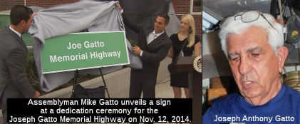 The portion of I-10 between I-5 and I-710 in the County of Los Angeles (~ LA
18.48 to LA 21.308) is officially designated the "Joe Gatto Memorial
Highway". It was named in memory of Joseph “Joe” Gatto,
born in 1934 in Pueblo, Colorado. Gatto served in the United States Army,
and became the first in his family to attend college, graduating with a
bachelor’s degree from California State University, Los Angeles; a
master’s in education from Pepperdine University; and a
master’s in design from California State University, Los Angeles.
Gatto began traveling the world in the 1960s, visiting western Europe,
Russia, Egypt, and Japan. He married in 1968 and subsequently chose to
return to California, the place of his education, with his wife and three
children. Gatto settled his family in the Silver Lake neighborhood of Los
Angeles in 1978. Mr. Gatto exhibited an extraordinary commitment to hard
work and a dedication to his family by working three jobs at times,
teaching on Saturdays, and working night shifts at Dodger Stadium. Mr.
Gatto, a beloved teacher full of life and with so much talent to share,
retired after over 47 years in the classroom as an art and design teacher
at the primary, secondary, and postsecondary levels. He helped found the
Los Angeles County High School for the Arts, where he served as Dean of
the Visual Arts Department. He also taught at other educational
institutions, including Granada Hills High School; Pierce College;
California State University, Northridge; California State University, Los
Angeles; the Otis Art Institute; and the Art Center in Pasadena. Mr.
Gatto’s work ethic and commitment to his pupils and students were
represented by his 100 percent attendance record at school and work since
he was in the fourth grade. Mr. Gatto inspired thousands of pupils and
students with a unique philosophy on teaching. He was awarded the Bravo
Award as the California Arts Teacher of the Year in 1986; was a recipient
of the National Distinguished Teacher Award; was honored at the White
House in 1988, 1989, and 1998; received the California and Pacific Region
Art Educator of the Year award in 1990; and received a distinguished
teacher award from the City of Los Angeles in 2003. Mr. Gatto exhibited
his love for the earth and passion for art through his hand-crafted
jewelry line, Wear Art Now. He traveled to exhibit Wear Art Now at shows
and in museums, including the Los Angeles Museum of Art, the Craft and
Folk Art Museum, and the Museum of Science and Industry. Gatto, a retired
teacher and jewelry maker who was well-known in his community, was found
inside his Bright Lane home on the night of Nov. 13, 2013. He was slumped
over a desk with a gunshot wound to the abdomen. His death rattled the
quiet Silver Lake neighborhood he had long called home, marking the
neighborhood's first homicide in more than a year. As of November 2014,
the case was still unsolved. At that time, Deputy Chief Kirk Albanese told
reporters that detectives had recovered physical evidence connected with
the unsolved case, but declined to say what the evidence was. He said
investigators had not identified any suspects but believed whoever was
responsible for the killing had fled the Los Angeles area. The city was
urging anyone with information, no matter how small, to contact police at
(213) 486-6890 or anonymously at (800) 222-TIPS. The city has also offered
a $50,000 reward for information in Gatto's death. Gatto's son,
Assemblyman Mike Gatto (D-Los Angeles), said his father's death "rocked my
family" and that "This is one of the rare times where the public's help in
solving a murder is crucial. In fact, it might be the only thing that can
solve this case at this point. Please, please come forward. Help my
family." The dedication ceremony for the designated freeway section was
held in front of a mural of Gatto at the Los Angeles County High School
for the Arts, which he helped found, in November 2014 (the picture, which
is from the LA Times, shows Assemblymen Ian Calderon, left, and Mike
Gatto, who is joined by his wife, Danielle). It was named by Assembly
Concurrent Resolution 173, Resolution Chapter 184, 9/11/2014.
The portion of I-10 between I-5 and I-710 in the County of Los Angeles (~ LA
18.48 to LA 21.308) is officially designated the "Joe Gatto Memorial
Highway". It was named in memory of Joseph “Joe” Gatto,
born in 1934 in Pueblo, Colorado. Gatto served in the United States Army,
and became the first in his family to attend college, graduating with a
bachelor’s degree from California State University, Los Angeles; a
master’s in education from Pepperdine University; and a
master’s in design from California State University, Los Angeles.
Gatto began traveling the world in the 1960s, visiting western Europe,
Russia, Egypt, and Japan. He married in 1968 and subsequently chose to
return to California, the place of his education, with his wife and three
children. Gatto settled his family in the Silver Lake neighborhood of Los
Angeles in 1978. Mr. Gatto exhibited an extraordinary commitment to hard
work and a dedication to his family by working three jobs at times,
teaching on Saturdays, and working night shifts at Dodger Stadium. Mr.
Gatto, a beloved teacher full of life and with so much talent to share,
retired after over 47 years in the classroom as an art and design teacher
at the primary, secondary, and postsecondary levels. He helped found the
Los Angeles County High School for the Arts, where he served as Dean of
the Visual Arts Department. He also taught at other educational
institutions, including Granada Hills High School; Pierce College;
California State University, Northridge; California State University, Los
Angeles; the Otis Art Institute; and the Art Center in Pasadena. Mr.
Gatto’s work ethic and commitment to his pupils and students were
represented by his 100 percent attendance record at school and work since
he was in the fourth grade. Mr. Gatto inspired thousands of pupils and
students with a unique philosophy on teaching. He was awarded the Bravo
Award as the California Arts Teacher of the Year in 1986; was a recipient
of the National Distinguished Teacher Award; was honored at the White
House in 1988, 1989, and 1998; received the California and Pacific Region
Art Educator of the Year award in 1990; and received a distinguished
teacher award from the City of Los Angeles in 2003. Mr. Gatto exhibited
his love for the earth and passion for art through his hand-crafted
jewelry line, Wear Art Now. He traveled to exhibit Wear Art Now at shows
and in museums, including the Los Angeles Museum of Art, the Craft and
Folk Art Museum, and the Museum of Science and Industry. Gatto, a retired
teacher and jewelry maker who was well-known in his community, was found
inside his Bright Lane home on the night of Nov. 13, 2013. He was slumped
over a desk with a gunshot wound to the abdomen. His death rattled the
quiet Silver Lake neighborhood he had long called home, marking the
neighborhood's first homicide in more than a year. As of November 2014,
the case was still unsolved. At that time, Deputy Chief Kirk Albanese told
reporters that detectives had recovered physical evidence connected with
the unsolved case, but declined to say what the evidence was. He said
investigators had not identified any suspects but believed whoever was
responsible for the killing had fled the Los Angeles area. The city was
urging anyone with information, no matter how small, to contact police at
(213) 486-6890 or anonymously at (800) 222-TIPS. The city has also offered
a $50,000 reward for information in Gatto's death. Gatto's son,
Assemblyman Mike Gatto (D-Los Angeles), said his father's death "rocked my
family" and that "This is one of the rare times where the public's help in
solving a murder is crucial. In fact, it might be the only thing that can
solve this case at this point. Please, please come forward. Help my
family." The dedication ceremony for the designated freeway section was
held in front of a mural of Gatto at the Los Angeles County High School
for the Arts, which he helped found, in November 2014 (the picture, which
is from the LA Times, shows Assemblymen Ian Calderon, left, and Mike
Gatto, who is joined by his wife, Danielle). It was named by Assembly
Concurrent Resolution 173, Resolution Chapter 184, 9/11/2014.
(Source: ACR 173, LATimes
11/12/14; Image Source: KTLA; LA Times Homicide Report)
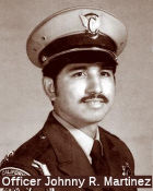 The portion of I-10 from eastbound PM LA 22.31
to westbound PM LA 22.33 (basically, the two pieces of South Fremont
Avenue) in the City of Alhambra is officially named the "CHP Officer
Johnny R. Martinez Memorial Highway". This segment was named in
honor of Officer Johnny Ramirez Martinez, who was born June 14, 1948, to
Bill and Vera Martinez, in Fayette, North Carolina. Officer Martinez
graduated from Chaffey High School in 1966, and joined the United States
Marine Corps shortly after graduation. He proudly served the Marine Corps
for four years and achieved the rank of sergeant as a Vietnam veteran.
Prior to becoming a patrol officer for the Department of the California
Highway Patrol (CHP), Officer Martinez was employed by Alcoa Aluminum of
Corona as an X-ray technician. Officer Martinez graduated from the
California Highway Patrol Academy on December 1, 1977, and upon
graduation, was assigned to the East Los Angeles area, where he proudly
served for four years. Officer Martinez, badge number 8813, was killed in
the line of duty on October 2, 1981. While clearing debris from the San
Bernardino Freeway, he and his partner were gunned down by two paranoid
robbery suspects. Although he was rushed to the hospital, Officer Martinez
succumbed to his injuries and died at Alhambra Community Hospital. Officer
Martinez was known for being a man of principle and integrity. He was a
loyal family man, a wonderful father and husband , and a dedicated
officer. His greatest joys were his wife, his children, and riding
motorcycles. Named by Assembly Concurrant Resolution (ACR) 159, 8/23/2010,
Resolution Chapter 104.
The portion of I-10 from eastbound PM LA 22.31
to westbound PM LA 22.33 (basically, the two pieces of South Fremont
Avenue) in the City of Alhambra is officially named the "CHP Officer
Johnny R. Martinez Memorial Highway". This segment was named in
honor of Officer Johnny Ramirez Martinez, who was born June 14, 1948, to
Bill and Vera Martinez, in Fayette, North Carolina. Officer Martinez
graduated from Chaffey High School in 1966, and joined the United States
Marine Corps shortly after graduation. He proudly served the Marine Corps
for four years and achieved the rank of sergeant as a Vietnam veteran.
Prior to becoming a patrol officer for the Department of the California
Highway Patrol (CHP), Officer Martinez was employed by Alcoa Aluminum of
Corona as an X-ray technician. Officer Martinez graduated from the
California Highway Patrol Academy on December 1, 1977, and upon
graduation, was assigned to the East Los Angeles area, where he proudly
served for four years. Officer Martinez, badge number 8813, was killed in
the line of duty on October 2, 1981. While clearing debris from the San
Bernardino Freeway, he and his partner were gunned down by two paranoid
robbery suspects. Although he was rushed to the hospital, Officer Martinez
succumbed to his injuries and died at Alhambra Community Hospital. Officer
Martinez was known for being a man of principle and integrity. He was a
loyal family man, a wonderful father and husband , and a dedicated
officer. His greatest joys were his wife, his children, and riding
motorcycles. Named by Assembly Concurrant Resolution (ACR) 159, 8/23/2010,
Resolution Chapter 104.
(Image Source: California Assn of Highway Patrolmen)
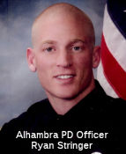 The portion of I-10 between South Marguerita Avenue and South
Almansor Street (LA 23.12 to LA 24.31), in the City of Alhambra, is named
the "Officer Ryan Stringer Memorial Highway". It was named in
memory of Officer Ryan Stringer, who was born in the City of Los Angeles
and grew up in the City of Whittier, graduating from Whittier Christian
High School. Officer Stringer attended Fullerton College and Rio Hondo
Community College after working for his father's construction business for
several years. Officer Stringer entered the Police Academy at Rio Hondo
and graduated in February of 2009 and was sworn in as an Alhambra Police
Officer on February 26, 2009. During his two-year tenure with the Alhambra
Police Department, Officer Stringer worked in the Field Services Division,
Patrol Section. Officer Stringer showed his friendship, camaraderie,
teamwork, and competitive drive as a member of the Alhambra Police
Department's Baker-to-Vegas Challenge Cup Relay Team. Officer Stringer
displayed his determination and will to succeed during his recovery from a
life-threatening motorcycle accident that occurred in July 2010. After
spending several weeks in a coma and being temporarily disabled, Officer
Stringer made a full recovery within six months and returned to active
duty as a police officer in January 2011. Unfortunately, on July 10, 2011,
at approximately 2:30 a.m., Officer Ryan Stringer was killed in a tragic
accident at the age of 26 while responding to a possible robbery in the
rear parking lot of 100 North First Street in the City of Alhambra.
Coworkers, friends, and family recall Officer Stringer's good-natured
disposition, healthy sense of humor, strong sense of adventure, and desire
to excel at whatever he set out to do. Named by Assembly Concurrent
Resolution 100, Resolution Chapter 109, on September 4, 2012.
The portion of I-10 between South Marguerita Avenue and South
Almansor Street (LA 23.12 to LA 24.31), in the City of Alhambra, is named
the "Officer Ryan Stringer Memorial Highway". It was named in
memory of Officer Ryan Stringer, who was born in the City of Los Angeles
and grew up in the City of Whittier, graduating from Whittier Christian
High School. Officer Stringer attended Fullerton College and Rio Hondo
Community College after working for his father's construction business for
several years. Officer Stringer entered the Police Academy at Rio Hondo
and graduated in February of 2009 and was sworn in as an Alhambra Police
Officer on February 26, 2009. During his two-year tenure with the Alhambra
Police Department, Officer Stringer worked in the Field Services Division,
Patrol Section. Officer Stringer showed his friendship, camaraderie,
teamwork, and competitive drive as a member of the Alhambra Police
Department's Baker-to-Vegas Challenge Cup Relay Team. Officer Stringer
displayed his determination and will to succeed during his recovery from a
life-threatening motorcycle accident that occurred in July 2010. After
spending several weeks in a coma and being temporarily disabled, Officer
Stringer made a full recovery within six months and returned to active
duty as a police officer in January 2011. Unfortunately, on July 10, 2011,
at approximately 2:30 a.m., Officer Ryan Stringer was killed in a tragic
accident at the age of 26 while responding to a possible robbery in the
rear parking lot of 100 North First Street in the City of Alhambra.
Coworkers, friends, and family recall Officer Stringer's good-natured
disposition, healthy sense of humor, strong sense of adventure, and desire
to excel at whatever he set out to do. Named by Assembly Concurrent
Resolution 100, Resolution Chapter 109, on September 4, 2012.
(Image source: Alhambra PD Facebook Page)
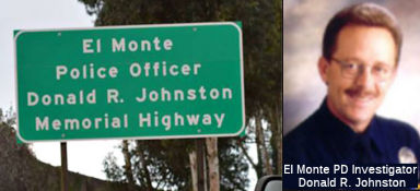 The portion of this freeway between the intersection with Route 19 in the City of Rosemead and the
intersection with I-605 in the City of Baldwin Park (~ LA 26.908 to LA
31.048) is officially named the "El Monte Police Officer Donald Ralph
Johnston Memorial Highway". It was named in honor of El Monte Police
Officer Donald Ralph Johnston. Officer Donald Ralph Johnston was born in
Wichita, Kansas, on November 11, 1954. When he was four, his parents moved
the family to La Puente, California where his father Corky joined ranks of
the El Monte Police Department. Officer Johnston graduated from La Puente
High School in 1972, and became the proud father of a son Eric who later
continued the Johnston legacy with the El Monte Police Department (3rd
generation). In 1985, Officer Johnston became a reserve officer for the
City of El Monte until he became a full-time officer in 1988. Officer
Johnston volunteered in the Adopt-a-Cop program at Wilkerson School. On
January 9, 1990, Officer Johnston responded to a call of a person trying
to pass a bad check at a bank, and was shot and paralyzed by the suspect
after selflessly pushing a bystander out of harm's way. He was awarded the
City of El Monte Medals of Valor, Distinguished Service, and Purple Heart,
received commendations and awards from the United States Congress,
Governor Deukmejian, Governor Wilson, the California State Legislature,
the Office of Attorney General, the County of Los Angeles, the American
Police Hall of Fame, and numerous other local and national organizations.
On January 29, 1991, Officer Johnston returned to work at the El Monte
Police Department in a wheelchair, and was assigned to the Community
Relations Unit as a detective handling missing persons investigations, all
the while continuing his community involvement by mentoring disabled
students. In 1993, Officer Johnston secured a position as the first
regular police helicopter observer, and was able to experience the
excitement of street patrol once again. Officer Johnston's work was so
exceptional that he received many accolades for his service; and in 1997,
Officer Johnston developed the S.T.R.I.V.E (Success Through Recognizing
Individual Volition and Excellence) program, and visited schools to tell
his story and inspire students to overcome their own obstacles. After
retiring from active duty on September 1, 2001, Officer Johnston refused
to quit, and with his letter of retirement, submitted a request to stay
with the El Monte Police Department as a reserve officer, despite his
declining health and chronic pain. Officer Johnston passed away on
November 22, 2002. Named by Assembly Concurrent Resolution 71, Resolution
Chapter 115, 8/25/2003.
The portion of this freeway between the intersection with Route 19 in the City of Rosemead and the
intersection with I-605 in the City of Baldwin Park (~ LA 26.908 to LA
31.048) is officially named the "El Monte Police Officer Donald Ralph
Johnston Memorial Highway". It was named in honor of El Monte Police
Officer Donald Ralph Johnston. Officer Donald Ralph Johnston was born in
Wichita, Kansas, on November 11, 1954. When he was four, his parents moved
the family to La Puente, California where his father Corky joined ranks of
the El Monte Police Department. Officer Johnston graduated from La Puente
High School in 1972, and became the proud father of a son Eric who later
continued the Johnston legacy with the El Monte Police Department (3rd
generation). In 1985, Officer Johnston became a reserve officer for the
City of El Monte until he became a full-time officer in 1988. Officer
Johnston volunteered in the Adopt-a-Cop program at Wilkerson School. On
January 9, 1990, Officer Johnston responded to a call of a person trying
to pass a bad check at a bank, and was shot and paralyzed by the suspect
after selflessly pushing a bystander out of harm's way. He was awarded the
City of El Monte Medals of Valor, Distinguished Service, and Purple Heart,
received commendations and awards from the United States Congress,
Governor Deukmejian, Governor Wilson, the California State Legislature,
the Office of Attorney General, the County of Los Angeles, the American
Police Hall of Fame, and numerous other local and national organizations.
On January 29, 1991, Officer Johnston returned to work at the El Monte
Police Department in a wheelchair, and was assigned to the Community
Relations Unit as a detective handling missing persons investigations, all
the while continuing his community involvement by mentoring disabled
students. In 1993, Officer Johnston secured a position as the first
regular police helicopter observer, and was able to experience the
excitement of street patrol once again. Officer Johnston's work was so
exceptional that he received many accolades for his service; and in 1997,
Officer Johnston developed the S.T.R.I.V.E (Success Through Recognizing
Individual Volition and Excellence) program, and visited schools to tell
his story and inspire students to overcome their own obstacles. After
retiring from active duty on September 1, 2001, Officer Johnston refused
to quit, and with his letter of retirement, submitted a request to stay
with the El Monte Police Department as a reserve officer, despite his
declining health and chronic pain. Officer Johnston passed away on
November 22, 2002. Named by Assembly Concurrent Resolution 71, Resolution
Chapter 115, 8/25/2003.
(Image source: The Friday Flyer; OfficerDown
Memorial Page)
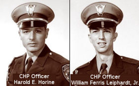 The portion of I-10
from the Baldwin Park Blvd Overcrossing to the Sunset Avenue Undercrossing
in the County of Los Angeles (~ LA 32.186 to LA 34.856) is officially
named the CHP Officers Harold E. Horine and Bill Leiphardt Memorial
Highway. It was named in memory of California Highway Patrol
Officers Harold Horine and Bill Leiphardt, who made the ultimate sacrifice
while performing their sworn duty. Specifically, on May 13, 1978,
California Highway Patrol Officers Harold Horine and Bill Leiphardt were
struck by a drunk driver while investigating a roadside crash involving an
abandoned vehicle. Officer Harold Eugene Horine was born in 1939 in El
Monte, California. Officer Horine, badge number 6686, graduated from the
California Highway Patrol Academy in 1968 and, upon graduation, was
assigned to the Baldwin Park Area Office, where he proudly served for
approximately 10 years. Officer William Ferris Leiphardt, Jr. was born in
1939 in La Junta, Colorado. Officer Leiphardt served in the United States
Air Force from 1958 to 1964 before deciding to join the Department of the
California Highway Patrol. Officer Leiphardt, badge number 4911, was
assigned to the Baldwin Park Area Office, where he proudly served for
approximately 12 years. Named by Senate Concurrent Resolution 57,
Resolution Chapter 5, 2/3/2014.
The portion of I-10
from the Baldwin Park Blvd Overcrossing to the Sunset Avenue Undercrossing
in the County of Los Angeles (~ LA 32.186 to LA 34.856) is officially
named the CHP Officers Harold E. Horine and Bill Leiphardt Memorial
Highway. It was named in memory of California Highway Patrol
Officers Harold Horine and Bill Leiphardt, who made the ultimate sacrifice
while performing their sworn duty. Specifically, on May 13, 1978,
California Highway Patrol Officers Harold Horine and Bill Leiphardt were
struck by a drunk driver while investigating a roadside crash involving an
abandoned vehicle. Officer Harold Eugene Horine was born in 1939 in El
Monte, California. Officer Horine, badge number 6686, graduated from the
California Highway Patrol Academy in 1968 and, upon graduation, was
assigned to the Baldwin Park Area Office, where he proudly served for
approximately 10 years. Officer William Ferris Leiphardt, Jr. was born in
1939 in La Junta, Colorado. Officer Leiphardt served in the United States
Air Force from 1958 to 1964 before deciding to join the Department of the
California Highway Patrol. Officer Leiphardt, badge number 4911, was
assigned to the Baldwin Park Area Office, where he proudly served for
approximately 12 years. Named by Senate Concurrent Resolution 57,
Resolution Chapter 5, 2/3/2014.
(Image source: California Assn of Highway Patrolmen
- Horine - Leipthardt)
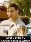 The portion of I-10 between Vincent Avenue and
Grand Avenue in the City of West Covina (~ LA 35.398 to LA 38.522) is
officially named the "West Covina Police Officer Kenneth Wrede Memorial
Highway". It was named in memory of Officer Kenneth Wrede of the
City of West Covina Police Department, who was killed in the line of duty
on August 31, 1983, in the City of West Covina while responding to a call
regarding a suspicious person. Officer Wrede was a longtime resident of
Southern California and a 1975 graduate of Katella High School in Anaheim.
He received his associates degree in criminal justice from Fullerton
College and was pursuing a bachelor's degree at the time of his death.
Named by Assembly Concurrent Resolution (ACR) 104, Resolution Chapter 102,
on 8/16/2006.
The portion of I-10 between Vincent Avenue and
Grand Avenue in the City of West Covina (~ LA 35.398 to LA 38.522) is
officially named the "West Covina Police Officer Kenneth Wrede Memorial
Highway". It was named in memory of Officer Kenneth Wrede of the
City of West Covina Police Department, who was killed in the line of duty
on August 31, 1983, in the City of West Covina while responding to a call
regarding a suspicious person. Officer Wrede was a longtime resident of
Southern California and a 1975 graduate of Katella High School in Anaheim.
He received his associates degree in criminal justice from Fullerton
College and was pursuing a bachelor's degree at the time of his death.
Named by Assembly Concurrent Resolution (ACR) 104, Resolution Chapter 102,
on 8/16/2006.
(Image source: LA County Police Officers Memorial FB Page; KennethScott
Wrede Memorial FB Page)
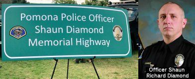 The portion of Route 10 from the Route 57
Interchange near Pomona to the North Towne Avenue exit near Pomona in the
County of Los Angeles (~ LA 42.506 to LA 46.43) is officially named the "Pomona
Police Officer Shaun Diamond Memorial Highway." It was named in
memory of Officer Shaun Richard Diamond of the Pomona Police Department.
On October 29, 2014, Officer Diamond, age 45, succumbed to a gunshot wound
he sustained the previous day while performing his sworn duty with the
department’s SWAT unit. A 16-year veteran of the law enforcement
community, having worked for police departments in Los Angeles and
Montebello prior to joining the Pomona Police Department (PPD) in 2006,
Officer Diamond had a passion for working SWAT, and as a member of the
PPD’s SWAT unit for the past six years, he had served on dozens of
SWAT operations and shared his expertise as a field training officer, in
which capacity he was responsible for training new recruits. In his most
recent assignment to the Pomona Downtown District Enforcement Team,
Officer Diamond worked as a law enforcement liaison with the business
community and the community at large, giving generously of his time to
such local events and organizations as the Special Olympics and Tip-A-Cop.
His community outreach efforts also included K-9 and SWAT demonstrations
for local schoolchildren. Named by Assembly Concurrent Resolution 104, Resolution Chapter 53, on 6/1/2016.
The portion of Route 10 from the Route 57
Interchange near Pomona to the North Towne Avenue exit near Pomona in the
County of Los Angeles (~ LA 42.506 to LA 46.43) is officially named the "Pomona
Police Officer Shaun Diamond Memorial Highway." It was named in
memory of Officer Shaun Richard Diamond of the Pomona Police Department.
On October 29, 2014, Officer Diamond, age 45, succumbed to a gunshot wound
he sustained the previous day while performing his sworn duty with the
department’s SWAT unit. A 16-year veteran of the law enforcement
community, having worked for police departments in Los Angeles and
Montebello prior to joining the Pomona Police Department (PPD) in 2006,
Officer Diamond had a passion for working SWAT, and as a member of the
PPD’s SWAT unit for the past six years, he had served on dozens of
SWAT operations and shared his expertise as a field training officer, in
which capacity he was responsible for training new recruits. In his most
recent assignment to the Pomona Downtown District Enforcement Team,
Officer Diamond worked as a law enforcement liaison with the business
community and the community at large, giving generously of his time to
such local events and organizations as the Special Olympics and Tip-A-Cop.
His community outreach efforts also included K-9 and SWAT demonstrations
for local schoolchildren. Named by Assembly Concurrent Resolution 104, Resolution Chapter 53, on 6/1/2016.
(Image Source: Daily Bulletin, 5/27/2016; Twitter)
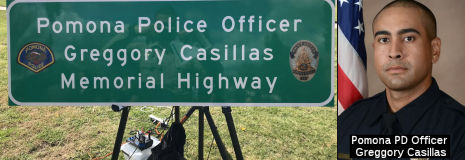 The portion of I-10 between the North San
Antonio Avenue undercrossing (LA 46.718) in the County of Los Angeles, to
the Mountain Avenue undercrossing (SBD 2.37) in the County of San
Bernardino, is named the "Pomona Police Officer Greggory Casillas
Memorial Highway". It was named in memory of Officer Greggory
Jonathan Casillas of the Pomona Police Department, who on March 9, 2018
died while serving in the line of duty; his untimely death in the pursuit
of the highest ideals of public safety has brought immense sorrow and loss
to the people of the local community and throughout the state and the
countless individuals whose lives he touched. Born in April 1987, in
Glendale, Officer Greggory Casillas began his career in public safety in
March 2015, serving as a Pomona Police Records Specialist until November
of that year, at which time he became a Pomona Police Jailer and served in
that capacity for one year, later entering the police academy on March 19,
2017, and being sworn as a Pomona Police Officer on September 7, 2017.
Officer Casillas was a true gentleman in every sense of the word, and will
be remembered by his coworkers for his dedication to details and his
honesty and by his siblings as a calm and collected individual who always
thought ahead and was committed to accomplishing his goals. Throughout his
tenure with the Pomona Police Department, Officer Casillas, a mature,
stable, and responsible man, exemplified the true character of the brave
men and women who devote their time and energy to the perilous duties of
law enforcement, and he was renowned among his fellow officers for loving,
honoring, and being dedicated to his family, the uniform, and the law
enforcement community, all of which were indelible and inseparable in his
life. Named by Assembly Concurrent Resolution (ACR) 236, Res. Chapter 157,
8/17/2018.
The portion of I-10 between the North San
Antonio Avenue undercrossing (LA 46.718) in the County of Los Angeles, to
the Mountain Avenue undercrossing (SBD 2.37) in the County of San
Bernardino, is named the "Pomona Police Officer Greggory Casillas
Memorial Highway". It was named in memory of Officer Greggory
Jonathan Casillas of the Pomona Police Department, who on March 9, 2018
died while serving in the line of duty; his untimely death in the pursuit
of the highest ideals of public safety has brought immense sorrow and loss
to the people of the local community and throughout the state and the
countless individuals whose lives he touched. Born in April 1987, in
Glendale, Officer Greggory Casillas began his career in public safety in
March 2015, serving as a Pomona Police Records Specialist until November
of that year, at which time he became a Pomona Police Jailer and served in
that capacity for one year, later entering the police academy on March 19,
2017, and being sworn as a Pomona Police Officer on September 7, 2017.
Officer Casillas was a true gentleman in every sense of the word, and will
be remembered by his coworkers for his dedication to details and his
honesty and by his siblings as a calm and collected individual who always
thought ahead and was committed to accomplishing his goals. Throughout his
tenure with the Pomona Police Department, Officer Casillas, a mature,
stable, and responsible man, exemplified the true character of the brave
men and women who devote their time and energy to the perilous duties of
law enforcement, and he was renowned among his fellow officers for loving,
honoring, and being dedicated to his family, the uniform, and the law
enforcement community, all of which were indelible and inseparable in his
life. Named by Assembly Concurrent Resolution (ACR) 236, Res. Chapter 157,
8/17/2018.
(Image Source: Twitter, Officer Down Memorial Page)
The portion of this freeway in San Bernardino and Riverside counties is named the "Redlands Freeway". This is because the route traverses the City of Redlands.
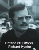 The portion of I-10 in the City of Ontario between the
intersection of Euclid Avenue and the 6th Street overcrossing
(~ SBD 3.532 to SBD 4.329) as the "Officer Richard Hyche Memorial
Freeway". It was named in honor of Officer Richard Hyche, a
four-year veteran of the Ontario Police Department. Officer Hyche was
fatally wounded on October 15, 1975, and at the time was the first Ontario
police officer killed in the line of duty since 1957. Officer Hyche was
born on April 27, 1944, in Long Beach; served in the United States Marine
Corps; attended the San Bernardino County Sheriff's Academy; worked at the
Glenn Helen Maximum and Minimum County Jail Facility for two years; and
was hired as a police officer by the Ontario Police Department on July 23,
1971. Officer Hyche was killed by a single gunshot by a suspect being
sought in connection with a murder that had occurred the previous day at
the Pepper Tree Motel. The suspect was later convicted and sentenced to
life in state prison, and subsequently escaped from prison, fled to
Montana, and was eventually killed after a deadly crime spree. Officer
Hyche is still remembered today by former supervisors and colleagues as an
excellent officer who was always outgoing and friendly, who enjoyed his
work as a police officer, and who had a strong commitment to his fellow
officers. Named by Senate Concurrent Resolution (SCR) 95, Resolution
Chapter 93, on 8/11/2006.
The portion of I-10 in the City of Ontario between the
intersection of Euclid Avenue and the 6th Street overcrossing
(~ SBD 3.532 to SBD 4.329) as the "Officer Richard Hyche Memorial
Freeway". It was named in honor of Officer Richard Hyche, a
four-year veteran of the Ontario Police Department. Officer Hyche was
fatally wounded on October 15, 1975, and at the time was the first Ontario
police officer killed in the line of duty since 1957. Officer Hyche was
born on April 27, 1944, in Long Beach; served in the United States Marine
Corps; attended the San Bernardino County Sheriff's Academy; worked at the
Glenn Helen Maximum and Minimum County Jail Facility for two years; and
was hired as a police officer by the Ontario Police Department on July 23,
1971. Officer Hyche was killed by a single gunshot by a suspect being
sought in connection with a murder that had occurred the previous day at
the Pepper Tree Motel. The suspect was later convicted and sentenced to
life in state prison, and subsequently escaped from prison, fled to
Montana, and was eventually killed after a deadly crime spree. Officer
Hyche is still remembered today by former supervisors and colleagues as an
excellent officer who was always outgoing and friendly, who enjoyed his
work as a police officer, and who had a strong commitment to his fellow
officers. Named by Senate Concurrent Resolution (SCR) 95, Resolution
Chapter 93, on 8/11/2006.
(Image source: Ontario Police Museum - Lest We Forget)
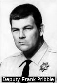 The portion of Route 10 from ~ Mulberry Ave, E of
Commerce Drive to ~ Citrus Ave (SBD 12.25 to SBD 15.25) in the City of
Fontana is named the “Deputy Frank M. Pribble Memorial Highway”.
This segment was named in memory of San Bernardino County Sheriff Deputy
Frank Marion Pribble. Deputy Pribble joined the San Bernardino County
Sheriff's Department in March 1965 and was assigned to the Fontana
Station. Deputy Pribble was very well respected and well known throughout
the department in this large county, particularly in Fontana where he
worked for 10 years and served as a deputy sheriff. Deputy Pribble was a
mentor to the new deputies assigned to the Fontana Station and many
deputies would wait after their shifts for a chance to ride with Pribble,
who would take the new officers around the perimeter of the Fontana beat
and carefully instruct them on the hazards of the area. On July 6, 1975,
Deputy Pribble was on patrol in a rest area on Route 10 for a suspect
wanted in a drive-by shooting when he was fatally shot in the line of
duty. Even during the last moments of his life, Deputy Pribble exhibited
selfless regard for life when he told a woman who was trying to assist the
wounded officer to "Get out of the way; I don't want you people to get
hurt." Named by Assembly Concurrent Resolution (ACR) 96, Resolution
Chapter 72, on 7/3/2008.
The portion of Route 10 from ~ Mulberry Ave, E of
Commerce Drive to ~ Citrus Ave (SBD 12.25 to SBD 15.25) in the City of
Fontana is named the “Deputy Frank M. Pribble Memorial Highway”.
This segment was named in memory of San Bernardino County Sheriff Deputy
Frank Marion Pribble. Deputy Pribble joined the San Bernardino County
Sheriff's Department in March 1965 and was assigned to the Fontana
Station. Deputy Pribble was very well respected and well known throughout
the department in this large county, particularly in Fontana where he
worked for 10 years and served as a deputy sheriff. Deputy Pribble was a
mentor to the new deputies assigned to the Fontana Station and many
deputies would wait after their shifts for a chance to ride with Pribble,
who would take the new officers around the perimeter of the Fontana beat
and carefully instruct them on the hazards of the area. On July 6, 1975,
Deputy Pribble was on patrol in a rest area on Route 10 for a suspect
wanted in a drive-by shooting when he was fatally shot in the line of
duty. Even during the last moments of his life, Deputy Pribble exhibited
selfless regard for life when he told a woman who was trying to assist the
wounded officer to "Get out of the way; I don't want you people to get
hurt." Named by Assembly Concurrent Resolution (ACR) 96, Resolution
Chapter 72, on 7/3/2008.
(Image source: SBD County Frank Bland Memorial)
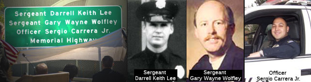 The portion of I-10 between Cedar Avenue
and Pepper Avenue in the City of Rialto (~ SBD R18.453 to SBD 20.96) is
named the "Sergeant Darrell Keith Lee, Sergeant Gary Wayne Wolfley, and
Officer Sergio Carrera Jr. Memorial Highway". It was named in memory
of Sergeant Darrell Keith Lee, Sergeant Gary Wayne Wolfley, and Officer
Sergio Carrera Jr., the only three officers lost in the line of duty
between the founding of the Rialto Police Department in 1911 and 2012. All
three police officers died from injuries sustained during violent
confrontations while performing their respective duties as California
police officers. Sergeant Darrell Keith Lee, of the City of Rialto, passed
away on July 24, 1970, when he suffered a heart attack as a result of an
injury sustained in the line of duty. Sergeant Lee was born to Minnie
Price (Lee) of Texas and Glenn Lee of Oklahoma on February 7, 1932, in
Southard, Oklahoma. Sergeant Lee attended Rialto Junior High and San
Bernardino High School in the cities of Rialto and San Bernardino,
respectively. Sergeant Lee served in the United States Marine Corps in
Japan and Korea. He joined the Rialto Police Department in 1958, and was
promoted to sergeant in 1963. Sergeant Lee was a lifelong resident of
Rialto, California, and was a great public speaker who enjoyed speaking
with all the local groups. Sergeant Gary Wayne Wolfley, of the City of
Rialto, passed away on March 3, 1986, when he was shot while handling a
call for service in the City of Rialto. Sergeant Wolfley was born to
William and Patricia Wolfley on September 22, 1955, in the Black Hills of
South Dakota. Sergeant Wolfley attended Eisenhower High School in the City
of Rialto. During his teenage years, he was a Rialto Police Cadet and a
member of the Civil Air Patrol. Sergeant Wolfley worked for the City of
Rialto as a police dispatcher until he realized his dream of becoming a
police officer in 1977. In March 1985, he was promoted to the rank of
Sergeant. Sergeant Wolfley was well-known in the community and was always
there to help his friends and family. Sergio Carrera Jr., of the City of
Rialto, passed away on October 18, 2007, when he was shot and killed
during a raid for illegal drugs. Officer Carrera was born to Sergio
Carrera Sr. and Aurora Lopez on March 5, 1978, in Lynwood, California.
Officer Carrera attended Valley View High School in Moreno Valley,
California, and San Bernardino Valley College, where he completed his
police academy training in 2003. Officer Carrera was a four-year veteran
of the Rialto Police Department and a member of the SWAT team. Officer
Carrera was a loving husband and wonderful father, was well-known for his
contagious sense of humor and laughter, and was uncomplicated and
straightforward in his relationships, which allowed him to accept people
for who they were. Named by Assembly Concurrent Resolution 100, Resolution
Chapter 109, on September 4, 2012.
The portion of I-10 between Cedar Avenue
and Pepper Avenue in the City of Rialto (~ SBD R18.453 to SBD 20.96) is
named the "Sergeant Darrell Keith Lee, Sergeant Gary Wayne Wolfley, and
Officer Sergio Carrera Jr. Memorial Highway". It was named in memory
of Sergeant Darrell Keith Lee, Sergeant Gary Wayne Wolfley, and Officer
Sergio Carrera Jr., the only three officers lost in the line of duty
between the founding of the Rialto Police Department in 1911 and 2012. All
three police officers died from injuries sustained during violent
confrontations while performing their respective duties as California
police officers. Sergeant Darrell Keith Lee, of the City of Rialto, passed
away on July 24, 1970, when he suffered a heart attack as a result of an
injury sustained in the line of duty. Sergeant Lee was born to Minnie
Price (Lee) of Texas and Glenn Lee of Oklahoma on February 7, 1932, in
Southard, Oklahoma. Sergeant Lee attended Rialto Junior High and San
Bernardino High School in the cities of Rialto and San Bernardino,
respectively. Sergeant Lee served in the United States Marine Corps in
Japan and Korea. He joined the Rialto Police Department in 1958, and was
promoted to sergeant in 1963. Sergeant Lee was a lifelong resident of
Rialto, California, and was a great public speaker who enjoyed speaking
with all the local groups. Sergeant Gary Wayne Wolfley, of the City of
Rialto, passed away on March 3, 1986, when he was shot while handling a
call for service in the City of Rialto. Sergeant Wolfley was born to
William and Patricia Wolfley on September 22, 1955, in the Black Hills of
South Dakota. Sergeant Wolfley attended Eisenhower High School in the City
of Rialto. During his teenage years, he was a Rialto Police Cadet and a
member of the Civil Air Patrol. Sergeant Wolfley worked for the City of
Rialto as a police dispatcher until he realized his dream of becoming a
police officer in 1977. In March 1985, he was promoted to the rank of
Sergeant. Sergeant Wolfley was well-known in the community and was always
there to help his friends and family. Sergio Carrera Jr., of the City of
Rialto, passed away on October 18, 2007, when he was shot and killed
during a raid for illegal drugs. Officer Carrera was born to Sergio
Carrera Sr. and Aurora Lopez on March 5, 1978, in Lynwood, California.
Officer Carrera attended Valley View High School in Moreno Valley,
California, and San Bernardino Valley College, where he completed his
police academy training in 2003. Officer Carrera was a four-year veteran
of the Rialto Police Department and a member of the SWAT team. Officer
Carrera was a loving husband and wonderful father, was well-known for his
contagious sense of humor and laughter, and was uncomplicated and
straightforward in his relationships, which allowed him to accept people
for who they were. Named by Assembly Concurrent Resolution 100, Resolution
Chapter 109, on September 4, 2012.
(Image source: Find a Grave; OfficerDown
Memorial Page; Officer Down Memorial Page; Find a Grave)
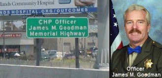 The portion of I-10 in San Bernardino County between S.
Waterman Ave and Tennessee St in Redlands (SBD 25.26 to SBD 29.82) is
named the "Officer James M. Goodman Memorial Highway". This segment
was named in memory of CHP Officer James M. Goodman, who was killed in the
line of duty on June 3, 2004. He was traveling west on his department
motorcycle in the City of Redlands, attempting to overtake a vehicle he
believed to be involved in a hit and run accident, when a van, traveling
north on Nevada Street, entered the intersection from the south directly
in the path of Officer Goodman. Officer Goodman was unable to avoid a
collision and broadsided the van, and thereafter succumbed to the injuries
he received from the traffic collision. He was born on September 11, 1955,
in Martinez, California, was raised in the Bay Area, and graduated in 1973
from Pinole High School. He honorably served in the United States Army for
nearly eight years and dedicated four years to reserve duty, ultimately
achieving the rank of sergeant. Officer Goodman joined the California
Highway Patrol on January 9, 1984. After successfully completing his
training at the California Highway Patrol Academy, he reported to the
Redwood City area on May 24, 1984. On August 20, 1985, Officer Goodman was
awarded a California Commission on Peace Officer Standards and Training
Basic Certificate; and on April 1, 1987, Officer Goodman transferred to
the San Jose area. On May 2, 1989, he was assigned to the Oakland area; on
October 1, 1993, he was assigned to the Golden Gate Division; on June 26,
2000, he was assigned to the Oakland area; and on March 1, 2001, he was
assigned to the San Bernardino area. Over the years, Officer Goodman
earned numerous certificates of achievement in the field of law
enforcement. While stationed in the Oakland area, Officer Goodman was the
first officer to arrive on scene after the Loma Prieta Earthquake occurred
on October 17, 1989; and on the day of the earthquake, Officer Goodman
helped to release a driver trapped under a collapsed portion of I-880 by
crawling through a small space only accessible by removing several pieces
of his safety equipment. For three hours, while the highway continued to
settle from aftershocks, he and his colleagues worked to free the driver.
In honor of this heroic act, he and two other officers were awarded the
Medal of Valor by Former Governor Pete Wilson. Additionally, on November
25, 1989, Officer Goodman received a Meritorious Award from the office of
the Mayor of the City of Oakland for his valor, gallantry, and courage
during the 1989 earthquake. Officer Goodman made significant contributions
to traffic safety and to the motoring public while serving at each
assigned area and served for 20 years as a sworn peace officer for the
California Highway Patrol. He was known by his fellow officers for his
outstanding dedication to the department and to the protection of the
citizens of our state. Named by Assembly Concurrent Resolution (ACR) 41,
Resolution Chapter 72, on 7/3/2007.
The portion of I-10 in San Bernardino County between S.
Waterman Ave and Tennessee St in Redlands (SBD 25.26 to SBD 29.82) is
named the "Officer James M. Goodman Memorial Highway". This segment
was named in memory of CHP Officer James M. Goodman, who was killed in the
line of duty on June 3, 2004. He was traveling west on his department
motorcycle in the City of Redlands, attempting to overtake a vehicle he
believed to be involved in a hit and run accident, when a van, traveling
north on Nevada Street, entered the intersection from the south directly
in the path of Officer Goodman. Officer Goodman was unable to avoid a
collision and broadsided the van, and thereafter succumbed to the injuries
he received from the traffic collision. He was born on September 11, 1955,
in Martinez, California, was raised in the Bay Area, and graduated in 1973
from Pinole High School. He honorably served in the United States Army for
nearly eight years and dedicated four years to reserve duty, ultimately
achieving the rank of sergeant. Officer Goodman joined the California
Highway Patrol on January 9, 1984. After successfully completing his
training at the California Highway Patrol Academy, he reported to the
Redwood City area on May 24, 1984. On August 20, 1985, Officer Goodman was
awarded a California Commission on Peace Officer Standards and Training
Basic Certificate; and on April 1, 1987, Officer Goodman transferred to
the San Jose area. On May 2, 1989, he was assigned to the Oakland area; on
October 1, 1993, he was assigned to the Golden Gate Division; on June 26,
2000, he was assigned to the Oakland area; and on March 1, 2001, he was
assigned to the San Bernardino area. Over the years, Officer Goodman
earned numerous certificates of achievement in the field of law
enforcement. While stationed in the Oakland area, Officer Goodman was the
first officer to arrive on scene after the Loma Prieta Earthquake occurred
on October 17, 1989; and on the day of the earthquake, Officer Goodman
helped to release a driver trapped under a collapsed portion of I-880 by
crawling through a small space only accessible by removing several pieces
of his safety equipment. For three hours, while the highway continued to
settle from aftershocks, he and his colleagues worked to free the driver.
In honor of this heroic act, he and two other officers were awarded the
Medal of Valor by Former Governor Pete Wilson. Additionally, on November
25, 1989, Officer Goodman received a Meritorious Award from the office of
the Mayor of the City of Oakland for his valor, gallantry, and courage
during the 1989 earthquake. Officer Goodman made significant contributions
to traffic safety and to the motoring public while serving at each
assigned area and served for 20 years as a sworn peace officer for the
California Highway Patrol. He was known by his fellow officers for his
outstanding dedication to the department and to the protection of the
citizens of our state. Named by Assembly Concurrent Resolution (ACR) 41,
Resolution Chapter 72, on 7/3/2007.
(Image source: California Assn of Highway Patrolmen)
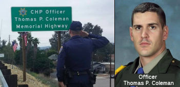 The portion of Route 10 in the vicinity of
Texas Street to South Wabash Avenue (SBD 30.377 to SBD 34.288), in the
County of San Bernardino, is named the "CHP Officer Thomas P. Coleman
Memorial Highway". It was named in memory of CHP Officer Thomas
Philip Coleman, who was born October 6, 1976, in West Covina, California,
to Robert and Janice Coleman. He was one of five children that included
two boys, Thomas and Joseph, and three girls, Jennifer, Kathleen and Mary.
He graduated from Damien High School in 1994 and joined the United States
Marine Corps in September of 1996. Prior to joining the California Highway
Patrol (CHP), Thomas P. Coleman served as a Marine Security Guard for the
United States Marine Corps. In 2003, CHP Officer Thomas P. Coleman, badge
number 17338, graduated from the CHP Academy and was assigned to the
Altadena Area Office. After 60 months of service in the Altadena area,
Officer Thomas P. Coleman was transferred to the San Bernardino area and
was assigned to motorcycle duty on June 12, 2008. On June 11, 2010,
Officer Thomas P. Coleman was in pursuit of a traffic violator when his
motorcycle collided with a semitrailer truck. Shortly after the accident,
Officer Thomas P. Coleman succumbed to his injuries and was pronounced
dead at the scene. Officer Coleman was a hard-working, dedicated officer
who loved his job and enjoyed the people he worked with. He was known for
being a loyal family man and a wonderful father and husband. His greatest
joys were playing with his children, riding his motorcycle, hiking, and
watching football and movies. Officer Thomas P. Coleman was admired for
his passion for his career, his "smirk," his sense of humor, and his hugs.
Named by Senate Concurrent Resolution 25, Resolution Chapter 89, on
September 15, 2011.
The portion of Route 10 in the vicinity of
Texas Street to South Wabash Avenue (SBD 30.377 to SBD 34.288), in the
County of San Bernardino, is named the "CHP Officer Thomas P. Coleman
Memorial Highway". It was named in memory of CHP Officer Thomas
Philip Coleman, who was born October 6, 1976, in West Covina, California,
to Robert and Janice Coleman. He was one of five children that included
two boys, Thomas and Joseph, and three girls, Jennifer, Kathleen and Mary.
He graduated from Damien High School in 1994 and joined the United States
Marine Corps in September of 1996. Prior to joining the California Highway
Patrol (CHP), Thomas P. Coleman served as a Marine Security Guard for the
United States Marine Corps. In 2003, CHP Officer Thomas P. Coleman, badge
number 17338, graduated from the CHP Academy and was assigned to the
Altadena Area Office. After 60 months of service in the Altadena area,
Officer Thomas P. Coleman was transferred to the San Bernardino area and
was assigned to motorcycle duty on June 12, 2008. On June 11, 2010,
Officer Thomas P. Coleman was in pursuit of a traffic violator when his
motorcycle collided with a semitrailer truck. Shortly after the accident,
Officer Thomas P. Coleman succumbed to his injuries and was pronounced
dead at the scene. Officer Coleman was a hard-working, dedicated officer
who loved his job and enjoyed the people he worked with. He was known for
being a loyal family man and a wonderful father and husband. His greatest
joys were playing with his children, riding his motorcycle, hiking, and
watching football and movies. Officer Thomas P. Coleman was admired for
his passion for his career, his "smirk," his sense of humor, and his hugs.
Named by Senate Concurrent Resolution 25, Resolution Chapter 89, on
September 15, 2011.
(Image source: Officer Tom Coleman Memorial FB Page)
 The portion of this freeway from the Beaumont Avenue/Route 79 exit to the Sunset Avenue Exit, in the County of Riverside
(~ RIV 7.608 to RIV 11.353) is named the "CDF Firefighter Chris Kanton
Memorial Highway". This segment was named in memory of California
Department of Forestry and Fire Protection (CDF) Firefighter Chris Kanton,
at 23 years of age, who died in the line of duty on Saturday, August 6,
2005, in the County of Riverside. While responding to storm-related
accidents, CDF Firefighter Chris Kanton was traveling in a CDF fire engine
on I-10 east of Route 60 when the engine left the highway and traveled
down a steep embankment, struck several trees, and came to rest on the
roadway below. CDF Firefighter Chris Kanton, graduated from high school in
2000 in Paso Robles, California; attended and graduated from the Allan
Hancock Fire Academy in Santa Maria, California; and subsequently
completed HAZMAT training and served on the HAZMAT team at Station 81 in
Bermuda Dunes and other locations as a full-time firefighter. He later
transferred to Station 58 in Moreno Valley, where he served as a
Firefighter II. Named by Assembly Concurrent Resolution (ACR) 10,
Resolution Chapter 64, on 7/3/2007.
The portion of this freeway from the Beaumont Avenue/Route 79 exit to the Sunset Avenue Exit, in the County of Riverside
(~ RIV 7.608 to RIV 11.353) is named the "CDF Firefighter Chris Kanton
Memorial Highway". This segment was named in memory of California
Department of Forestry and Fire Protection (CDF) Firefighter Chris Kanton,
at 23 years of age, who died in the line of duty on Saturday, August 6,
2005, in the County of Riverside. While responding to storm-related
accidents, CDF Firefighter Chris Kanton was traveling in a CDF fire engine
on I-10 east of Route 60 when the engine left the highway and traveled
down a steep embankment, struck several trees, and came to rest on the
roadway below. CDF Firefighter Chris Kanton, graduated from high school in
2000 in Paso Robles, California; attended and graduated from the Allan
Hancock Fire Academy in Santa Maria, California; and subsequently
completed HAZMAT training and served on the HAZMAT team at Station 81 in
Bermuda Dunes and other locations as a full-time firefighter. He later
transferred to Station 58 in Moreno Valley, where he served as a
Firefighter II. Named by Assembly Concurrent Resolution (ACR) 10,
Resolution Chapter 64, on 7/3/2007.
(Image source: National Fallen Firefighters Foundation)
 The five-mile portion of I-10
from the 22nd Street undercrossing to the Malki Road
undercrossing in Banning, California, County of Riverside (~ RIV R11.984
to RIV R16.407), is named the "CAL FIRE Firefighter Christopher Lee
Douglas Memorial Highway". It was named in memory of California
Department of Forestry and Fire Protection (CAL FIRE) Firefighter
Christopher Lee Douglas, who passed away in the line of duty on July 5,
2013, at 41 years of age, while responding to a traffic accident in
Riverside County. Firefighter Douglas was born in Colorado Springs,
Colorado, and attended Widefield High School. He later attended Palomar
College in Vista, California, graduating at the top of his class and
earning his paramedic license. Firefighter Douglas was an 11-year veteran
of the United States Air Force, enlisting in 1992. While stationed at
Vandenberg Air Force Base, he earned the rank of Staff Sergeant, attended
Airman Leadership School, and was a Missile and Space Systems Maintenance
Apprentice. During his Air Force career, he earned the Air Force
Achievement Medal, the Air Force Commendation Medal, the Air Force
Longevity Service Award with 1 device, the Air Force Training Ribbon, and
the National Defense Service Medal. Firefighter Douglas had a passion for
firefighting, beginning his career as a volunteer firefighter paramedic in
1999. At his graduation ceremony from the Company Officer’s Academy,
he received the Carpe Diem Award for leadership. In 2004, Firefighter
Douglas began his career with CAL FIRE at La Quinta Fire Station #32 as a
Firefighter II/Paramedic and was promoted to Fire Apparatus
Engineer/Paramedic on June 4, 2013. In his spare time, Firefighter Douglas
enjoyed surfing, playing the guitar, cooking, working on cars, traveling,
and spending time with his friends. Above all else, he valued spending
time with his family. On July 5, 2013, Firefighter Douglas was leaving the
scene of a medical emergency when his fire engine was dispatched to
another call, a traffic accident. While preparing to respond to the
traffic accident, Firefighter Douglas was struck by a pickup truck while
he was along the side of his fire engine, and succumbed to his injuries a
few hours later. Named by Senate Concurrent Resolution (SCR) 22, Res.
Chapter 107, Statutes of 2015, on July 16, 2015.
The five-mile portion of I-10
from the 22nd Street undercrossing to the Malki Road
undercrossing in Banning, California, County of Riverside (~ RIV R11.984
to RIV R16.407), is named the "CAL FIRE Firefighter Christopher Lee
Douglas Memorial Highway". It was named in memory of California
Department of Forestry and Fire Protection (CAL FIRE) Firefighter
Christopher Lee Douglas, who passed away in the line of duty on July 5,
2013, at 41 years of age, while responding to a traffic accident in
Riverside County. Firefighter Douglas was born in Colorado Springs,
Colorado, and attended Widefield High School. He later attended Palomar
College in Vista, California, graduating at the top of his class and
earning his paramedic license. Firefighter Douglas was an 11-year veteran
of the United States Air Force, enlisting in 1992. While stationed at
Vandenberg Air Force Base, he earned the rank of Staff Sergeant, attended
Airman Leadership School, and was a Missile and Space Systems Maintenance
Apprentice. During his Air Force career, he earned the Air Force
Achievement Medal, the Air Force Commendation Medal, the Air Force
Longevity Service Award with 1 device, the Air Force Training Ribbon, and
the National Defense Service Medal. Firefighter Douglas had a passion for
firefighting, beginning his career as a volunteer firefighter paramedic in
1999. At his graduation ceremony from the Company Officer’s Academy,
he received the Carpe Diem Award for leadership. In 2004, Firefighter
Douglas began his career with CAL FIRE at La Quinta Fire Station #32 as a
Firefighter II/Paramedic and was promoted to Fire Apparatus
Engineer/Paramedic on June 4, 2013. In his spare time, Firefighter Douglas
enjoyed surfing, playing the guitar, cooking, working on cars, traveling,
and spending time with his friends. Above all else, he valued spending
time with his family. On July 5, 2013, Firefighter Douglas was leaving the
scene of a medical emergency when his fire engine was dispatched to
another call, a traffic accident. While preparing to respond to the
traffic accident, Firefighter Douglas was struck by a pickup truck while
he was along the side of his fire engine, and succumbed to his injuries a
few hours later. Named by Senate Concurrent Resolution (SCR) 22, Res.
Chapter 107, Statutes of 2015, on July 16, 2015.
(Image source: Find a Grave)
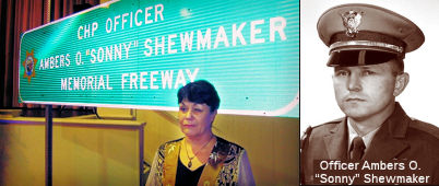 The portion of I-10 between Main Street and Verbenia Avenue (renamed Haugen-Lehmann Way in April 2018) in Cabazon (~ RIV R19.379 to RIV R24.534), in the
unincorporated area of the County of Riverside as the "CHP Officer
Ambers O. “Sonny” Shewmaker Memorial Highway". It was
named in memory of Officer Ambers O’Neal “Sonny”
Shewmaker, who was born October 10, 1941, to Earl and Eva Shewmaker in
Santa Maria, California. California Highway Patrol Cadet A.O.
“Sonny” Shewmaker entered the Department of the California
Highway Patrol Academy on March 3, 1969, and upon graduation was assigned
to the Riverside area office and was later transferred to the Banning area
office where he spent the remainder of his career. On November 23, 1969,
Officer “Sonny” Shewmaker, stopped a vehicle for speeding.
Unbeknownst to him, the car was stolen and the driver was wanted for an
earlier robbery in Riverside, California. As Officer Shewmaker was using
his radio, the suspect shot him point blank in the head. Officer Shewmaker
was taken to a hospital, but succumbed to his injuries on the morning of
November 24, 1969. In 1970, the Yucaipa Valley Little League created the
“Sonny Shewmaker Award for Best Sportsmanship” in honor of
Officer Shewmaker’s dedication to helping the youth of Yucaipa
Valley. Oddly enough, in 1973, the recipient of this award was a
12-year-old Brian Rezendes, who many years later married Officer
Shewmaker’s sister-in-law, Kim. It was named in recognition of
Officer Shewmaker’s contributions and sacrifice in serving and
protecting the citizens of California. Named by Assembly Concurrent
Resolution 100, Resolution Chapter 109, on September 4, 2012.
The portion of I-10 between Main Street and Verbenia Avenue (renamed Haugen-Lehmann Way in April 2018) in Cabazon (~ RIV R19.379 to RIV R24.534), in the
unincorporated area of the County of Riverside as the "CHP Officer
Ambers O. “Sonny” Shewmaker Memorial Highway". It was
named in memory of Officer Ambers O’Neal “Sonny”
Shewmaker, who was born October 10, 1941, to Earl and Eva Shewmaker in
Santa Maria, California. California Highway Patrol Cadet A.O.
“Sonny” Shewmaker entered the Department of the California
Highway Patrol Academy on March 3, 1969, and upon graduation was assigned
to the Riverside area office and was later transferred to the Banning area
office where he spent the remainder of his career. On November 23, 1969,
Officer “Sonny” Shewmaker, stopped a vehicle for speeding.
Unbeknownst to him, the car was stolen and the driver was wanted for an
earlier robbery in Riverside, California. As Officer Shewmaker was using
his radio, the suspect shot him point blank in the head. Officer Shewmaker
was taken to a hospital, but succumbed to his injuries on the morning of
November 24, 1969. In 1970, the Yucaipa Valley Little League created the
“Sonny Shewmaker Award for Best Sportsmanship” in honor of
Officer Shewmaker’s dedication to helping the youth of Yucaipa
Valley. Oddly enough, in 1973, the recipient of this award was a
12-year-old Brian Rezendes, who many years later married Officer
Shewmaker’s sister-in-law, Kim. It was named in recognition of
Officer Shewmaker’s contributions and sacrifice in serving and
protecting the citizens of California. Named by Assembly Concurrent
Resolution 100, Resolution Chapter 109, on September 4, 2012.
(Image source: Press Enterprise 11/20/2013; RedlandsPatch
11/13/2013)
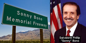 The portion of this freeway from a point just west of the Route 111 cutoff in
the Palm Springs area to a point at the bottom of the grade east of the
City of Coachella (~ RIV R23.937 to RIV R60.368) is named the "Sonny
Bono Memorial Freeway". As if you didn't know the story, Sonny Bono
left his boyhood home in Detroit, Michigan for Hollywood, California at a
young age to become a star in show business. His quest led him to a
laborer's job as a meat truck driver and deliveryman and then in
promotions for a record company. Sonny Bono parlayed those jobs into an
opportunity to showcase his ability as a showman and entertainer. Those
talents eventually led to a career of fame as a recording and television
star as part of the duo Sonny and Cher. Later, Sonny Bono pursued another
dream as a restaurant owner in Palm Springs. His concern on behalf of his
community as a businessman led him to public service eventually leading to
his election as Mayor of Palm Springs in 1988. Sonny Bono's public service
career eventually led him to the halls of the Congress of the United
States in 1994 as the Representative from the Coachella Valley and Western
Riverside County areas of southern California. Sonny Bono's achievements
as a Congressman brought needed national attention to the environmental
needs of the Salton Sea; he also worked on behalf of bringing the needed
federal funding for transportation and infrastructure projects for the
Coachella Valley, leading to funding for significant highway improvements
throughout the Coachella Valley and Riverside County. Named by Assembly
Concurrent Resolution 25, Resolution Chapter 58, June 4, 2001.
The portion of this freeway from a point just west of the Route 111 cutoff in
the Palm Springs area to a point at the bottom of the grade east of the
City of Coachella (~ RIV R23.937 to RIV R60.368) is named the "Sonny
Bono Memorial Freeway". As if you didn't know the story, Sonny Bono
left his boyhood home in Detroit, Michigan for Hollywood, California at a
young age to become a star in show business. His quest led him to a
laborer's job as a meat truck driver and deliveryman and then in
promotions for a record company. Sonny Bono parlayed those jobs into an
opportunity to showcase his ability as a showman and entertainer. Those
talents eventually led to a career of fame as a recording and television
star as part of the duo Sonny and Cher. Later, Sonny Bono pursued another
dream as a restaurant owner in Palm Springs. His concern on behalf of his
community as a businessman led him to public service eventually leading to
his election as Mayor of Palm Springs in 1988. Sonny Bono's public service
career eventually led him to the halls of the Congress of the United
States in 1994 as the Representative from the Coachella Valley and Western
Riverside County areas of southern California. Sonny Bono's achievements
as a Congressman brought needed national attention to the environmental
needs of the Salton Sea; he also worked on behalf of bringing the needed
federal funding for transportation and infrastructure projects for the
Coachella Valley, leading to funding for significant highway improvements
throughout the Coachella Valley and Riverside County. Named by Assembly
Concurrent Resolution 25, Resolution Chapter 58, June 4, 2001.
(Image sources: Flikr; Wikipedia)
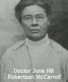 The portion of this freeway near Indio in Riverside County between the Jefferson Street and Indio Boulevard
interchange and the junction with Route 86 (~RIV R52.423 to RIV R57.73) is
officially named the "Doctor June McCarroll Memorial Freeway."
Doctor June McCarroll arrived in California in 1904, when she moved to
Indio in order to place her ailing husband in a health camp for persons
infected with tuberculosis. In Indio, she traveled, at first by horse and
buggy and later by horseback, to practice medicine on five Indian
reservations. She later became the doctor retained by the Southern Pacific
Railroad to treat its employees in the Coachella Valley. In later life,
she expressed regrets that younger doctors were seemingly unable to
function without modern hospitals and other conveniences when she had
sometimes operated on kitchen tables, explaining "I would clear off the
table, tie the patient down, and administer the anesthetic". She is also
credited with starting the first library in the Coachella Valley. She is
also known for her role in initiating the painting of centerlines upon
streets and highways. The Riverside County physician, who was known as Dr.
June, was driving home one day in 1917 when a truck forced her car off the
road. Convinced that lines would help drivers stay safely on the correct
sides of the road, McCarroll took her idea to Riverside County's Board of
Supervisors and Chamber of Commerce. When they didn't do anything, she set
an example by painting a mile-long, 4-inch-wide white stripe down the
center of Indio Boulevard, near her home. In 1924, after she and the Indio
Women's Club and the California Federation of Women's Clubs proposed it,
the idea of painting a centerline on state highways was adopted by the
California Highway Commission. The credit for painting white traffic
arrows on pavement, incidentally, apparently belongs to George S.
Hinckley, a traffic engineer who first used them in the plaza in front of
Redlands City Hall in 1910. Named by Senate Concurrent Resolution 58,
Chapter 105, August 17, 2000.
The portion of this freeway near Indio in Riverside County between the Jefferson Street and Indio Boulevard
interchange and the junction with Route 86 (~RIV R52.423 to RIV R57.73) is
officially named the "Doctor June McCarroll Memorial Freeway."
Doctor June McCarroll arrived in California in 1904, when she moved to
Indio in order to place her ailing husband in a health camp for persons
infected with tuberculosis. In Indio, she traveled, at first by horse and
buggy and later by horseback, to practice medicine on five Indian
reservations. She later became the doctor retained by the Southern Pacific
Railroad to treat its employees in the Coachella Valley. In later life,
she expressed regrets that younger doctors were seemingly unable to
function without modern hospitals and other conveniences when she had
sometimes operated on kitchen tables, explaining "I would clear off the
table, tie the patient down, and administer the anesthetic". She is also
credited with starting the first library in the Coachella Valley. She is
also known for her role in initiating the painting of centerlines upon
streets and highways. The Riverside County physician, who was known as Dr.
June, was driving home one day in 1917 when a truck forced her car off the
road. Convinced that lines would help drivers stay safely on the correct
sides of the road, McCarroll took her idea to Riverside County's Board of
Supervisors and Chamber of Commerce. When they didn't do anything, she set
an example by painting a mile-long, 4-inch-wide white stripe down the
center of Indio Boulevard, near her home. In 1924, after she and the Indio
Women's Club and the California Federation of Women's Clubs proposed it,
the idea of painting a centerline on state highways was adopted by the
California Highway Commission. The credit for painting white traffic
arrows on pavement, incidentally, apparently belongs to George S.
Hinckley, a traffic engineer who first used them in the plaza in front of
Redlands City Hall in 1910. Named by Senate Concurrent Resolution 58,
Chapter 105, August 17, 2000.
(Image source: Waymarking)
The portion of this freeway extending five miles to the east and five miles to the west of mile marker number 84 (~ RIV 79.000 to 89.000, near Bee Canyon Road at RIV 81.557) in Riverside County, located east of the Chiriaco Summit, is officially designated the "Veterans' Memorial Freeway". This is in honor of the veterans that have served the United States from the state of California. Named by Assembly Concurrent Resolution No. 137, Chapter 104, in 1994.
In additional to the other designations noted, Route 10 (in its entirety) has been officially
designated the "Christopher Columbus Transcontinental Highway",
although on the east coast, the corresponding sign is not on I-10 (it is
on I-40). It acquired this name in Assembly Concurrent Resolution No. 106,
Chapter 71, in 1976. Christopher Columbus was... oh well, just read Wikipedia. According to reports in 2003, the sign on I-10 has
disappeared.
In February 2021, a report was made back to the LA
County Board of Supervisors related to a motion made on October 13, 2020,
where the Board of Supervisors (Board) approved a motion directing the
Chief Executive Office (CEO), in partnership with the Los Angeles County
Native American Indian Commission (LANAIC), to collaborate with partners
in the State Legislature and the California State Transportation Agency
(CaISTA) for the removal and replacement of the 1-10 Freeway’s
designation as the Christopher Columbus Transcontinental Highway, and to
report back in 120 days. The Board further directed the Department of
Public Works (DPW), in partnership with LANAIC, to identify and map any
wayfinding or directional signage in Los Angeles County that
references the Christopher Columbus Transcontinental Highway; work with
the appropriate jurisdiction for the removal and/or replacement of
identified signs; and to report back in 120 days. The report found that
all 14 cities along I-10 in Los Angeles County did not identify any
wayfinding or directional signage referencing the Christopher Columbus
name within their respective jurisdictions. The report noted that LANAIC
staff, in consultation with LANAIC Chairwoman Chrissie Castro, is
developing draft joint resolution language to remove the name. The
language will reflect the Board’s intent to remove the positive
portrayal of Christopher Columbus in part because of the mental and
emotional stress such portrayal has on Native and indigenous populations
from the specified section of the 1-10 Freeway. Additionally, the language
will reflect the intent to rename that portion of the freeway following
consultation with area tribal leaders and key stakeholders. Prior to
submitting the finalized draft joint resolution language to the identified
legislative author, the Sacramento advocates and LANAIC will submit the
draft language to the authors of this Board motion to ensure it is aligned
with their original intent. The Sacramento advocates anticipate
identifying an author within the next 30 days to introduce the proposed
joint resolution, which is not subject to regular bill introduction
deadlines, and have presented the Board motion to legislative committee
staff and the Governor’s office to build support and address any
initial concerns and/or questions.
(Source: LA County Board of Supervisors, BOARD REPORT BACK: RENAMING THE CHRISTOPHER COLUMBUS TRANSCONTINENTAL HIGHWAY (ITEM NO. 59-G, AGENDA OF OCTOBER 13, 2020), 2/12/2021)
Named Structures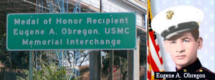 The I-5/I-10/Route 60/U 101 interchange (~ 10 LA S0.15), commonly referred to as the East Los
Angeles Interchange, is named the “Medal of Honor Recipient ,
Eugene A. Obregon, USMC, Memorial Interchange” (it was
originally named the “Marine Private First Class Eugene A.
Obregon Interchange”). This interchange was named in memory of
Medal of Honor Recipient Eugene A. Obregon, USMC. While serving as an
ammunition carrier with Golf Company, Third Battalion, Fifth Marine
Regiment, First Marine Division (Reinforced), during the Korean War, PFC
Obregon was killed in action on September 26, 1950. The machine-gun squad
of Private Obregon was temporarily pinned down by hostile fire; and during
this time, he observed a fellow marine fall wounded in the line of fire.
Armed only with a pistol, Private Obregon unhesitantly dashed from his
cover position to the side of the fallen marine. Firing his pistol with
one hand as he ran, Private Obregon grasped his comrade by the arm, and
despite the great peril to himself, dragged the marine to the side of the
road. Still under enemy fire, Private Obregon was bandaging the marine's
wounds when hostile troops began approaching their position. Quickly
seizing the wounded marine's rifle, Private Obregon placed his own body as
a shield in front of the wounded marine and lay there firing accurately
and effectively into the approaching enemy troops until he, himself, was
fatally wounded by enemy machine-gun fire. By his courageous fighting
spirit, and loyal devotion to duty, Private Obregon enabled his fellow
marines to rescue the wounded marine. By fate and courage, Private Obregon
is one of the valiant Mexican Americans to receive the Congressional Medal
of Honor, the nation's highest military honor for bravery. Named by Senate
Concurrent Resolution (SCR) 109, Resolution Chapter 66, on 6/26/2008.
The I-5/I-10/Route 60/U 101 interchange (~ 10 LA S0.15), commonly referred to as the East Los
Angeles Interchange, is named the “Medal of Honor Recipient ,
Eugene A. Obregon, USMC, Memorial Interchange” (it was
originally named the “Marine Private First Class Eugene A.
Obregon Interchange”). This interchange was named in memory of
Medal of Honor Recipient Eugene A. Obregon, USMC. While serving as an
ammunition carrier with Golf Company, Third Battalion, Fifth Marine
Regiment, First Marine Division (Reinforced), during the Korean War, PFC
Obregon was killed in action on September 26, 1950. The machine-gun squad
of Private Obregon was temporarily pinned down by hostile fire; and during
this time, he observed a fellow marine fall wounded in the line of fire.
Armed only with a pistol, Private Obregon unhesitantly dashed from his
cover position to the side of the fallen marine. Firing his pistol with
one hand as he ran, Private Obregon grasped his comrade by the arm, and
despite the great peril to himself, dragged the marine to the side of the
road. Still under enemy fire, Private Obregon was bandaging the marine's
wounds when hostile troops began approaching their position. Quickly
seizing the wounded marine's rifle, Private Obregon placed his own body as
a shield in front of the wounded marine and lay there firing accurately
and effectively into the approaching enemy troops until he, himself, was
fatally wounded by enemy machine-gun fire. By his courageous fighting
spirit, and loyal devotion to duty, Private Obregon enabled his fellow
marines to rescue the wounded marine. By fate and courage, Private Obregon
is one of the valiant Mexican Americans to receive the Congressional Medal
of Honor, the nation's highest military honor for bravery. Named by Senate
Concurrent Resolution (SCR) 109, Resolution Chapter 66, on 6/26/2008.
(Image source: Flikr; Alchetron)
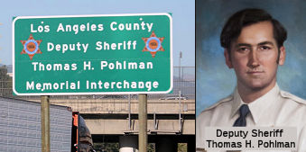 The interchange of I-10
and I-710 in the County of Los Angeles (~ LA 21.319) is named the "Los
Angeles County Deputy Sheriff Thomas H. Pohlman Memorial Interchange".
It was named in memory of Thomas H. Pohlman,a sheriff’s deputy with
the Los Angeles County Sheriff’s Department. Deputy Sheriff Pohlman
was born in July 1950, and was appointed as a sheriff’s deputy on
May 29, 1973. On April 19, 1978, Deputy Sheriff Pohlman was on patrol when
he smelled ether, used in the manufacture of the drug PCP, coming from a
nearby house. As Deputy Sheriff Pohlman and his partner approached the
house, a man bolted from the home. Deputy Sheriff Pohlman pursued the
suspect on foot, while his partner went back to the squad car to radio for
assistance. Deputy Sheriff Pohlman caught the suspect, and, while the
suspect was being handcuffed, the suspect gained control of Deputy Sheriff
Pohlman’s revolver and shot him. Deputy Sheriff Pohlman died at the
scene. Named by Assembly Concurrent Resolution 121, Res. Chapter 192,
Statutes of 2016, 9/9/2016
The interchange of I-10
and I-710 in the County of Los Angeles (~ LA 21.319) is named the "Los
Angeles County Deputy Sheriff Thomas H. Pohlman Memorial Interchange".
It was named in memory of Thomas H. Pohlman,a sheriff’s deputy with
the Los Angeles County Sheriff’s Department. Deputy Sheriff Pohlman
was born in July 1950, and was appointed as a sheriff’s deputy on
May 29, 1973. On April 19, 1978, Deputy Sheriff Pohlman was on patrol when
he smelled ether, used in the manufacture of the drug PCP, coming from a
nearby house. As Deputy Sheriff Pohlman and his partner approached the
house, a man bolted from the home. Deputy Sheriff Pohlman pursued the
suspect on foot, while his partner went back to the squad car to radio for
assistance. Deputy Sheriff Pohlman caught the suspect, and, while the
suspect was being handcuffed, the suspect gained control of Deputy Sheriff
Pohlman’s revolver and shot him. Deputy Sheriff Pohlman died at the
scene. Named by Assembly Concurrent Resolution 121, Res. Chapter 192,
Statutes of 2016, 9/9/2016
(Image source: Twitter; Find a Grave)
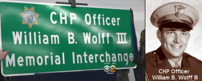 The I-10 interchange with I-605 at LA
31.151 in the County of Los Angeles is named the "CHP Officer William
B. Wolff III Memorial Interchange". It was named in memory of CHP
Officer William B. Wolff III, who was born in January 1946, in Akron,
Ohio. Officer Wolff graduated from Upper Darby High School in
Philadelphia, Pennsylvania, in 1964, and attended Cal Poly Pomona shortly
thereafter, where he received a degree in kinesiology. Officer Wolff was a
licensed vocational nurse and also served our country as a member of the
United States Navy prior to becoming a California Highway Patrol officer.
Officer Wolff is remembered as a proud father and grandfather. Officer
Wolff, badge number 8342, entered the California Highway Patrol Academy on
August 13, 1973, and, upon graduation, was assigned to the Baldwin Park
area, where he served for approximately five years. Officer Wolff was
killed in the line of duty on December 30, 1977, while making a traffic
stop along the I-10 freeway in Baldwin Park, when he was struck by a drunk
driver. The motorist who killed Officer Wolff was charged with felony
drunk driving. Officer Wolff was a hard working, dedicated officer who
loved his job and enjoyed the people he worked with. He was known for
being a loyal family man and a wonderful father. Named by Assembly
Concurrent Resolution 86, Resolution Chapter 185, on 09/21/15.
The I-10 interchange with I-605 at LA
31.151 in the County of Los Angeles is named the "CHP Officer William
B. Wolff III Memorial Interchange". It was named in memory of CHP
Officer William B. Wolff III, who was born in January 1946, in Akron,
Ohio. Officer Wolff graduated from Upper Darby High School in
Philadelphia, Pennsylvania, in 1964, and attended Cal Poly Pomona shortly
thereafter, where he received a degree in kinesiology. Officer Wolff was a
licensed vocational nurse and also served our country as a member of the
United States Navy prior to becoming a California Highway Patrol officer.
Officer Wolff is remembered as a proud father and grandfather. Officer
Wolff, badge number 8342, entered the California Highway Patrol Academy on
August 13, 1973, and, upon graduation, was assigned to the Baldwin Park
area, where he served for approximately five years. Officer Wolff was
killed in the line of duty on December 30, 1977, while making a traffic
stop along the I-10 freeway in Baldwin Park, when he was struck by a drunk
driver. The motorist who killed Officer Wolff was charged with felony
drunk driving. Officer Wolff was a hard working, dedicated officer who
loved his job and enjoyed the people he worked with. He was known for
being a loyal family man and a wonderful father. Named by Assembly
Concurrent Resolution 86, Resolution Chapter 185, on 09/21/15.
(Image sources: CBS2, California Assn of Highway Patrolmen)
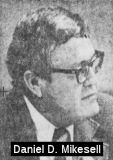 Bridge 54-0909 on I-15, the I-15/I-10 separation in San
Bernardino County near Ontario (SBD 009.94), is named the "Daniel D.
Mikesell Interchange". It was built in 1975, and was named in Senate
Concurrent Resolution 64, Chapter 84, in 1980. Daniel D. Mikesell was born
on March 1910 in Shawnee, Oklahoma. He attended UCLA and married Gabrielle
Lucas, a former Miss Ontario in 1936. He joined the San Bernardino County
Board of Supervisors in 1954 and served until he was elected Mayor of
Ontario in 1960. Re-elected to the Board of Supervisors in 1962, he
remained there until his retirement in 1974. He died on November 12, 2007
in Ontario. Known as a consummate politician, he was considered an
authority on aviation and transportation. He was instrumental in the
transfer of the Ontario Airport to the County of Los Angeles and the
I-10/I-15 freeway interchange is named in his honor for his decades-long
effort to construct the link between Ontario and Fontana. In particular,
Mikesell exerted exceptional effort beginning in 1955 to have the Devore
Cutoff included in the California Freeway and Expressway System.
Bridge 54-0909 on I-15, the I-15/I-10 separation in San
Bernardino County near Ontario (SBD 009.94), is named the "Daniel D.
Mikesell Interchange". It was built in 1975, and was named in Senate
Concurrent Resolution 64, Chapter 84, in 1980. Daniel D. Mikesell was born
on March 1910 in Shawnee, Oklahoma. He attended UCLA and married Gabrielle
Lucas, a former Miss Ontario in 1936. He joined the San Bernardino County
Board of Supervisors in 1954 and served until he was elected Mayor of
Ontario in 1960. Re-elected to the Board of Supervisors in 1962, he
remained there until his retirement in 1974. He died on November 12, 2007
in Ontario. Known as a consummate politician, he was considered an
authority on aviation and transportation. He was instrumental in the
transfer of the Ontario Airport to the County of Los Angeles and the
I-10/I-15 freeway interchange is named in his honor for his decades-long
effort to construct the link between Ontario and Fontana. In particular,
Mikesell exerted exceptional effort beginning in 1955 to have the Devore
Cutoff included in the California Freeway and Expressway System.
(Image source: UCR California Digital Newspaper Collection, SB Sun, 5/24/1974, Page 17)
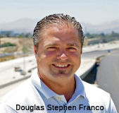 Bridge Number 54-1324 EA 08-1E030, SBD 20.96, the Pepper Avenue overcrossing on I-10 in the City of Colton is named the "Douglas
Stephen Franco Memorial Bridge". It was named in memory of
Douglas Stephen Franco, who served with the utmost distinction as a
resident engineer for projects conducted for the San Bernardino County
Transportation Authority (SBCTA) between 1995 and 2017. Mr. Franco earned
the respect of the public, elected officials, and colleagues for his
problem solving abilities, his willingness to listen and take action, his
sensible and creative approaches to construction challenges, his fair and
kind treatment of staff and coworkers, and his quick wit and pleasant
disposition in the work environment. During his accomplished tenure as a
resident engineer, Mr. Franco made tremendous contributions to the San
Bernardino Valley through major improvements to the I-215 Widening
Projects, the 5th Street Overcrossing, and the I- 10 and I-210
Freeways. Mr. Franco began his career working as an engineer for the
California Department of Transportation, Division of Structures, launching
more than 25 years of service, including 22 years with a construction
management consulting firm, dedicated to improving the quality of life for
the residents of southern California through enhancing the transportation
system. Mr. Franco earned a Bachelor of Science Degree in Civil
Engineering from the Loyola Marymount University. Mr. Franco passed away
too soon on June 12, 2017, at 48 years of age. Mr. Franco’s
long-standing service and stalwart commitment to transportation in the
Inland Empire makes it truly appropriate for the I-10 Pepper Avenue
overcrossing, Bridge Number 54-1324 EA 08-1E030, Post Mile 20.96, in the
City of Colton to be named in his honor. Named by Senate Concurrent
Resolution (SCR) 111, Res. Chapter 226, 9/11/2018.
Bridge Number 54-1324 EA 08-1E030, SBD 20.96, the Pepper Avenue overcrossing on I-10 in the City of Colton is named the "Douglas
Stephen Franco Memorial Bridge". It was named in memory of
Douglas Stephen Franco, who served with the utmost distinction as a
resident engineer for projects conducted for the San Bernardino County
Transportation Authority (SBCTA) between 1995 and 2017. Mr. Franco earned
the respect of the public, elected officials, and colleagues for his
problem solving abilities, his willingness to listen and take action, his
sensible and creative approaches to construction challenges, his fair and
kind treatment of staff and coworkers, and his quick wit and pleasant
disposition in the work environment. During his accomplished tenure as a
resident engineer, Mr. Franco made tremendous contributions to the San
Bernardino Valley through major improvements to the I-215 Widening
Projects, the 5th Street Overcrossing, and the I- 10 and I-210
Freeways. Mr. Franco began his career working as an engineer for the
California Department of Transportation, Division of Structures, launching
more than 25 years of service, including 22 years with a construction
management consulting firm, dedicated to improving the quality of life for
the residents of southern California through enhancing the transportation
system. Mr. Franco earned a Bachelor of Science Degree in Civil
Engineering from the Loyola Marymount University. Mr. Franco passed away
too soon on June 12, 2017, at 48 years of age. Mr. Franco’s
long-standing service and stalwart commitment to transportation in the
Inland Empire makes it truly appropriate for the I-10 Pepper Avenue
overcrossing, Bridge Number 54-1324 EA 08-1E030, Post Mile 20.96, in the
City of Colton to be named in his honor. Named by Senate Concurrent
Resolution (SCR) 111, Res. Chapter 226, 9/11/2018.
(Image source: LA Funeral)
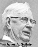 Bridge 53-1367 (now 54-0479, at SBD R24.23, rebuilt in 1972), the I-10/I-215 separation in San Bernardino County, is named the "James
A. Guthrie Memorial Interchange". It was built in 1960, and named by
Senate Concurrent Resolution 57, Chapter 193, in 1970. James A. Guthrie
was a presidential elector from California in 1956. He served from 1943 to
1967 as a member of the California Highway Commission. Guthrie, a
Republican, was reappointed twice to the CHC by Governor "Pat" Brown in
1961 and 1965, serving a total of three terms. He was born in San
Bernardino in 1988, and was editor and president of the San
Bernardino Sun and Telegram for many years. Through his paper, he
was a leader in the Good Roads program for San Bernadino County. He
pioneered the development of the roads later known as US 66, US 91, and US 99 (which became I-10). Guthrie was Past President of the San Bernadino
Chamber of Commerce, and a former director of the California Chamber of
Commerce. He was a member of the advisory board of the Automobile Club of
Southern California, the California Club of Los Angeles, and the Sutter
Club of Sacramento. He is in the Hall of Fame of the California Press Foundation.
Bridge 53-1367 (now 54-0479, at SBD R24.23, rebuilt in 1972), the I-10/I-215 separation in San Bernardino County, is named the "James
A. Guthrie Memorial Interchange". It was built in 1960, and named by
Senate Concurrent Resolution 57, Chapter 193, in 1970. James A. Guthrie
was a presidential elector from California in 1956. He served from 1943 to
1967 as a member of the California Highway Commission. Guthrie, a
Republican, was reappointed twice to the CHC by Governor "Pat" Brown in
1961 and 1965, serving a total of three terms. He was born in San
Bernardino in 1988, and was editor and president of the San
Bernardino Sun and Telegram for many years. Through his paper, he
was a leader in the Good Roads program for San Bernadino County. He
pioneered the development of the roads later known as US 66, US 91, and US 99 (which became I-10). Guthrie was Past President of the San Bernadino
Chamber of Commerce, and a former director of the California Chamber of
Commerce. He was a member of the advisory board of the Automobile Club of
Southern California, the California Club of Los Angeles, and the Sutter
Club of Sacramento. He is in the Hall of Fame of the California Press Foundation.
(Image source: California Highways and Public Works, Nov/Dec 1966)
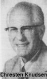 Bridge 54-0592, the I-10/Route 210 interchange in San
Bernardino County (SBD 029.82), is designated the "Chresten Knudsen
Interchange". It was built in 1962, and was named by Assembly
Concurrent Resolution 21, Chapter 47, in 1991. Chresten Knudsen served as
a member of the Redlands City Council and in the 1960's was appointed by
Governor Ronald Reagan to the Santa Ana Regional Water Quality Control
Board. When he retired from the Redlands City Council after three terms,
he cited increasing responsibilities for his civil engineering business as
the major factor in his decision. A Redlands native, Knudsen said he will
"continue to be keenly interested in the politics of the city and county."
As a councilman, Knudsen has represented Redlands and the council on many
boards and commissions. Among them are the city Redevelopment Commission,
Recreation Commission. Public Works Commission and San Bernardino
Associated Governments (SANBAGl, which he served as chairman in 1978-79
and as a member of the executive committee. He has also served on the
Regional Water Quality Control Board, Redlands Highland Yucaipa Resource
Conservation District, National Forest Recreation Association, Redlands
YMCA, Barton Flats Cabin Owners' Association. East Valley Planning Agency
and East Valley Airport Land Use Commission."
Bridge 54-0592, the I-10/Route 210 interchange in San
Bernardino County (SBD 029.82), is designated the "Chresten Knudsen
Interchange". It was built in 1962, and was named by Assembly
Concurrent Resolution 21, Chapter 47, in 1991. Chresten Knudsen served as
a member of the Redlands City Council and in the 1960's was appointed by
Governor Ronald Reagan to the Santa Ana Regional Water Quality Control
Board. When he retired from the Redlands City Council after three terms,
he cited increasing responsibilities for his civil engineering business as
the major factor in his decision. A Redlands native, Knudsen said he will
"continue to be keenly interested in the politics of the city and county."
As a councilman, Knudsen has represented Redlands and the council on many
boards and commissions. Among them are the city Redevelopment Commission,
Recreation Commission. Public Works Commission and San Bernardino
Associated Governments (SANBAGl, which he served as chairman in 1978-79
and as a member of the executive committee. He has also served on the
Regional Water Quality Control Board, Redlands Highland Yucaipa Resource
Conservation District, National Forest Recreation Association, Redlands
YMCA, Barton Flats Cabin Owners' Association. East Valley Planning Agency
and East Valley Airport Land Use Commission."
(Image/biography source: UCR Center for Bibliographic Studies and Research, California Digital Newspaper Collection, SB Sun, 2/3/1980, Page 26)
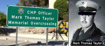 The I-10 and Date Palm Drive Memorial
Overcrossing in the County of Riverside (~ RIV 39.47) is named the "CHP
Officer Mark Thomas Taylor Memorial Overcrossing." It was named in
memory of Officer Mark Thomas Taylor. who was born on May 17, 1959, to
Thomas Claude and Lola Dee, in Benton Harbor, Michigan. Officer Taylor
graduated from Benton Harbor High School in 1977 and joined the United
States Marine Corps shortly thereafter. Officer Taylor served in the
United States Marine Corps from 1977 to 1984 and achieved the rank of
sergeant (E-5). After an honorable discharge, he applied to the CHP. On
March 18, 1985, Officer Taylor graduated from the CHP Academy and was
assigned to the Indio area. Officer Taylor married in 1977, and had a
daughter in 1978. Officer Taylor was killed in the line of duty on
November 26, 1987, during a routine traffic stop. While issuing a
citation, the offender's car was struck by another vehicle. The impact
propelled Officer Taylor onto the highway, where he was struck by the same
vehicle that had originally collided with the offender’s car.
Officer Taylor was a dedicated officer, family man, and a best friend to
many. He was known for his sense of humor and for making people smile. In
his spare time, he enjoyed spending time with family and friends, being
outdoors, running, traveling, and playing ping pong. Officer Taylor was
admired for his honesty, loyalty, and determination. He always
accomplished what he set out to do and never gave up. Named by Assembly
Concurrent Resolution 100, Resolution Chapter 109, on September 4, 2012.
The I-10 and Date Palm Drive Memorial
Overcrossing in the County of Riverside (~ RIV 39.47) is named the "CHP
Officer Mark Thomas Taylor Memorial Overcrossing." It was named in
memory of Officer Mark Thomas Taylor. who was born on May 17, 1959, to
Thomas Claude and Lola Dee, in Benton Harbor, Michigan. Officer Taylor
graduated from Benton Harbor High School in 1977 and joined the United
States Marine Corps shortly thereafter. Officer Taylor served in the
United States Marine Corps from 1977 to 1984 and achieved the rank of
sergeant (E-5). After an honorable discharge, he applied to the CHP. On
March 18, 1985, Officer Taylor graduated from the CHP Academy and was
assigned to the Indio area. Officer Taylor married in 1977, and had a
daughter in 1978. Officer Taylor was killed in the line of duty on
November 26, 1987, during a routine traffic stop. While issuing a
citation, the offender's car was struck by another vehicle. The impact
propelled Officer Taylor onto the highway, where he was struck by the same
vehicle that had originally collided with the offender’s car.
Officer Taylor was a dedicated officer, family man, and a best friend to
many. He was known for his sense of humor and for making people smile. In
his spare time, he enjoyed spending time with family and friends, being
outdoors, running, traveling, and playing ping pong. Officer Taylor was
admired for his honesty, loyalty, and determination. He always
accomplished what he set out to do and never gave up. Named by Assembly
Concurrent Resolution 100, Resolution Chapter 109, on September 4, 2012.
(Image source: Twitter; Officer Down Memorial Page)
The following is a list of all the named ditches, gulches, arroyos, and washes along I-10 in Riverside County. The origin of most of these names is unknown.
This route also has the following Safety Roadside Rest Areas:
 Historical Route
This portion of this freeway from Route 86 near Indio to I-5 in Los Angeles is designated as part of "Historic US Highway 99" by Assembly Concurrent Resolution 19, Chapter 73, in 1993.
 National Trails
 This route is part of the De Anza National Historic Trail.
 Holt Boulevard in Ontario was part of the Pikes Peak Ocean-to-Ocean Highway, which stretched between New York and Los Angeles,
running along Holt Blvd in Ontario. In 1920, Holt Blvd was the main route
linking Los Angeles to Palm Springs, according to the city of Ontario. At
that time Holt Blvd was a 4-lane highway, and it was long before the 10 or
60 freeways were built. Also during the time of the Ocean-to-Ocean
Highway, (about 1912) paved roads were rare and driving in a car for more
than 10 miles was considered to be a great adventure .
Holt Boulevard in Ontario was part of the Pikes Peak Ocean-to-Ocean Highway, which stretched between New York and Los Angeles,
running along Holt Blvd in Ontario. In 1920, Holt Blvd was the main route
linking Los Angeles to Palm Springs, according to the city of Ontario. At
that time Holt Blvd was a 4-lane highway, and it was long before the 10 or
60 freeways were built. Also during the time of the Ocean-to-Ocean
Highway, (about 1912) paved roads were rare and driving in a car for more
than 10 miles was considered to be a great adventure .
 The portion between Los Angeles and the Arizona Border appears to have been part of the Atlantic and Pacific Trail.
The portion between Los Angeles and Thermal appears to have been part of the Southern National Highway (SNH continued along US 99)
The portion of this segment between Indio (via Mecca) and Blythe was part of the "Hassayamph Trail". This portion is also named the "Sunkist Trail".
 Scenic Route
[SHC 263.3] From Route 38 near Redlands to Route 62 near Whitewater.
[Deleted by Senate Bill 169, August 26, 2013. Chapter 173.]
 Blue Star Memorial Highway
The portion of this route that is former US 99 was designated as a "North-South Blue Star Memorial Highway" by Senate Concurrent Resolution 33, Ch. 82 in 1947.
 Interregional Route
[SHC 164.10] Between the east urban limits of San Bernardino-Riverside and the Arizona state line.
 Classified Landcaped Freeway
The following segments are designated as Classified Landscaped Freeway:
| County | Route | Starting PM | Ending PM |
| Los Angeles | 10 | R2.16 | 8.90 |
| Los Angeles | 10 | 8.96 | 9.32 |
| Los Angeles | 10 | 9.39 | 14.36 |
| Los Angeles | 10 | 14.57 | 14.94 |
| Los Angeles | 10 | 17.98 | 18.39 |
| Los Angeles | 10 | S0.00 | 18.39 |
| Los Angeles | 10 | 18.39 | 19.71 |
| Los Angeles | 10 | 20.03 | 20.95 |
| Los Angeles | 10 | 21.01 | 21.68 |
| Los Angeles | 10 | 24.05 | 24.50 |
| Los Angeles | 10 | 24.80 | 25.90 |
| Los Angeles | 10 | 26.71 | 28.18 |
| Los Angeles | 10 | 28.25 | 30.74 |
| Los Angeles | 10 | 30.99 | 31.28 |
| Los Angeles | 10 | 31.28 | 31.65 |
| Los Angeles | 10 | 31.65 | 32.04 |
| Los Angeles | 10 | 32.04 | 32.08 |
| Los Angeles | 10 | 32.08 | 32.73 |
| Los Angeles | 10 | 32.73 | 32.77 |
| Los Angeles | 10 | 32.77 | 34.55 |
| Los Angeles | 10 | 35.04 | 38.15 |
| Los Angeles | 10 | 38.52 | 38.85 |
| Los Angeles | 10 | 41.58 | 42.34 |
| Los Angeles | 10 | 43.33 | 43.93 |
| Los Angeles | 10 | 43.97 | 45.74 |
| Los Angeles | 10 | 45.86 | 47.73 |
| Los Angeles | 10 | 47.92 | 48.27 |
| San Bernardino | 10 | 0.00 | 5.44 |
| San Bernardino | 10 | 5.63 | 6.30 |
| San Bernardino | 10 | 6.73 | 7.43 |
| San Bernardino | 10 | 11.74 | 19.73 |
| San Bernardino | 10 | 19.81 | 20.41 |
| San Bernardino | 10 | 20.48 | R21.39 |
| San Bernardino | 10 | R21.46 | R22.40 |
| San Bernardino | 10 | R22.44 | R22.85 |
| San Bernardino | 10 | R22.89 | R23.56 |
| San Bernardino | 10 | R23.97 | 30.06 |
| San Bernardino | 10 | 30.15 | 32.72 |
| Riverside | 10 | 6.98 | 8.21 |
| Riverside | 10 | 8.90 | 9.12 |
| Riverside | 10 | 9.60 | 9.83 |
| Riverside | 10 | 10.18 | 10.46 |
| Riverside | 10 | 10.75 | 12.98 |
| Riverside | 10 | 13.05 | R14.81 |
| Riverside | 10 | R151.88 | R152.42 |
| Riverside | 10 | R152.52 | R153.50 |
| Riverside | 10 | R153.93 | R154.50 |
| Riverside | 10 | R155.93 | R156.35 |
Post 1964 Signage History Prior to the designation of this routing as Interstate 10 on July 1,
1964, a routing similar to the current Route 10 routing had the
designation of US 70. US 70 began in downtown Los Angeles, followed Valley
Blvd, San Bernardino Road, Garvey-Holt Blvd, and Holt Street into Ontario,
and thence to points east. Between Los Angeles and Palm Springs, the
routing was cosigned with US 99. Portions were also cosigned with US 60.
Prior to the designation of this routing as Interstate 10 on July 1,
1964, a routing similar to the current Route 10 routing had the
designation of US 70. US 70 began in downtown Los Angeles, followed Valley
Blvd, San Bernardino Road, Garvey-Holt Blvd, and Holt Street into Ontario,
and thence to points east. Between Los Angeles and Palm Springs, the
routing was cosigned with US 99. Portions were also cosigned with US 60.
For those looking for old US 60/US 70 off of I-10, look for several small exits on I-10 between Indio and Blythe. There is a portion of US 60 between Corn Springs Rd. and Ford Dry Lake Rd.
Pre 1964 Signage History In 1934, Route 10 was signed along the
routing from Jct. Route 3 (US 101A, later Route 1) south of Venice to Jct.
US 101 at Santa Ana, via Manchester Avenue and Santa Ana Blvd. This
routing was LRN 174 from US 101A (Route 1, Lincoln Blvd) in Los Angeles
along Manchester and Firestone Blvds to US 101 in Norwalk. In 1961, the
routing was resigned as Route 42in preparation for the interstate. (1956
and 1960 maps shows it as Route 10; the 1963 state map (pre-renumbering)
shows it as Route 42). Before signage as US-101, the routing (signed as
Route 10, but LRN 174) continued on down to Orangethorpe, and then across
Orangethorpe past Route 101 (Spadra Road, at that time) and E through
Atwood, until joining the old surface route equivalent to US 101 (LRN 2).
Some maps show Route 10 ending at the junction with Route 18 (later
renumbered as Route 14, but cosigned with US 91; LRN 175 and LRN 178). It
appears that, by 1942, Route 10 was also signed as Bypass US 101.
In 1934, Route 10 was signed along the
routing from Jct. Route 3 (US 101A, later Route 1) south of Venice to Jct.
US 101 at Santa Ana, via Manchester Avenue and Santa Ana Blvd. This
routing was LRN 174 from US 101A (Route 1, Lincoln Blvd) in Los Angeles
along Manchester and Firestone Blvds to US 101 in Norwalk. In 1961, the
routing was resigned as Route 42in preparation for the interstate. (1956
and 1960 maps shows it as Route 10; the 1963 state map (pre-renumbering)
shows it as Route 42). Before signage as US-101, the routing (signed as
Route 10, but LRN 174) continued on down to Orangethorpe, and then across
Orangethorpe past Route 101 (Spadra Road, at that time) and E through
Atwood, until joining the old surface route equivalent to US 101 (LRN 2).
Some maps show Route 10 ending at the junction with Route 18 (later
renumbered as Route 14, but cosigned with US 91; LRN 175 and LRN 178). It
appears that, by 1942, Route 10 was also signed as Bypass US 101.
On August 21, 1933, it was reported that Firestone Boulevard, sometimes
known as Manchester Avenue, was widened from 40 feet to 74 feet and became
part of the California state highway system. The article noted that the
road will be one of the principal traffic arteries connecting the Coast
Highway, the southerly portion of Los Angeles, and contiguous territory
with Anaheim, Orange, and Santa Ana.
(Source: This Date in Los Angeles Transportation History, August 21)
When Route 10 (LRN 174) was first signed, it followed the general course
of the Southern Pacific Railroad from Firestone Boulevard to the Orange
County Line over numerous at-grade crossings. In Orange County, it
followed Grand Avenue and Lincoln Avenue from Buena Park to downtown
Anaheim. From downtown Anaheim, Route 10 followed Los Angeles Street
and southern Manchester Boulevard towards Santa Ana.
(Source: Gribblenation Blog (Tom Fearer), "Former California State Route 42 and Former California State Route 10", December 2021)
 On April 30, 1937, the last section of Manchester Blvd in
Anaheim was dedicated for public use. CHPW described the route as
“This route extends easterly from [LRN 60, Route 1] in Los Angeles
County at Playa del Rey, through the cities of Inglewood, Los Angeles and
South Gate, thence southeasterly in a direct line through the communities
of Downey, Norwalk and Buena Park, and through the southwesterly corner of
the city of Anaheim, connecting with [LRN 2, US 101] in Orange County at
Miraflores, and makes a total distance of 33.01 miles”. The
accompanying map shows the last sections being between Market and
Hillcrest in Inglewood (1935), Compton to Santa Fe (1934), and a large
section from perhaps near Downey Ave to near Anaheim Blvd (then, Los
Angeles Avenue, US 101) and Katella (1935-1937). This replaced an old
routing that ran from Firestone to Woodruff to Imperial Hwy to Studebaker
to Foster to Norwalk to Rosecrans to Stage Road to Grand/Stanton (Route 39, now Beach Blvd) to Lincoln Ave to Anaheim (routing is approximate,
attempting to track an old map). The CHPW articles notes “The plan
to project this Manchester Avenue route from the Roosevelt Highway (US 101A), near Playa del Rey, to connect with Coast Highway [LRN] 2 (US 101),
near Santa Ana, became a unified program of the State in 1933. when this
proposed route became a part of the State Highway System as [LRN 174]. At
that time portions of the road had been laid as city streets, but with no
connecting links. Then the only portion of this road improved to full
width pavement was 5.9 miles within the city of Los Angeles. Since January
9, 1934, when construction was started by the State on the first contract,
work has progressed steadily. With the cooperation of the cities and
counties, rights of way have been secured, widening and new construction
completed on 27.1 miles of highway, the completed roadway pavement surface
varying in widths from thirty feet to seventy-six feet.” The map
above is hard to follow as roads have changed names. Cerritos Ave appears
to have been renamed Lakewood Blvd, making Sumerset closer to Bellflower.
The split in Buena Park appears to be where Stage (veering to the left)
splits from Beach (note that Beach was previously Grand and Stanton)
On April 30, 1937, the last section of Manchester Blvd in
Anaheim was dedicated for public use. CHPW described the route as
“This route extends easterly from [LRN 60, Route 1] in Los Angeles
County at Playa del Rey, through the cities of Inglewood, Los Angeles and
South Gate, thence southeasterly in a direct line through the communities
of Downey, Norwalk and Buena Park, and through the southwesterly corner of
the city of Anaheim, connecting with [LRN 2, US 101] in Orange County at
Miraflores, and makes a total distance of 33.01 miles”. The
accompanying map shows the last sections being between Market and
Hillcrest in Inglewood (1935), Compton to Santa Fe (1934), and a large
section from perhaps near Downey Ave to near Anaheim Blvd (then, Los
Angeles Avenue, US 101) and Katella (1935-1937). This replaced an old
routing that ran from Firestone to Woodruff to Imperial Hwy to Studebaker
to Foster to Norwalk to Rosecrans to Stage Road to Grand/Stanton (Route 39, now Beach Blvd) to Lincoln Ave to Anaheim (routing is approximate,
attempting to track an old map). The CHPW articles notes “The plan
to project this Manchester Avenue route from the Roosevelt Highway (US 101A), near Playa del Rey, to connect with Coast Highway [LRN] 2 (US 101),
near Santa Ana, became a unified program of the State in 1933. when this
proposed route became a part of the State Highway System as [LRN 174]. At
that time portions of the road had been laid as city streets, but with no
connecting links. Then the only portion of this road improved to full
width pavement was 5.9 miles within the city of Los Angeles. Since January
9, 1934, when construction was started by the State on the first contract,
work has progressed steadily. With the cooperation of the cities and
counties, rights of way have been secured, widening and new construction
completed on 27.1 miles of highway, the completed roadway pavement surface
varying in widths from thirty feet to seventy-six feet.” The map
above is hard to follow as roads have changed names. Cerritos Ave appears
to have been renamed Lakewood Blvd, making Sumerset closer to Bellflower.
The split in Buena Park appears to be where Stage (veering to the left)
splits from Beach (note that Beach was previously Grand and Stanton)
(Source: This Date in Los Angeles Transportation History, April 30)
The April 30th, 1937 "Manchester Boulevard Extension" provided
a direct link between Downey and Anaheim that followed the Southern
Pacific Railroad. The Manchester Boulevard Extension bypassed
downtown Anaheim and tied into existing alignment of Route 10 (LRN 174) on
southern Manchester Boulevard at Miraflores near the outskirts of Santa
Ana. The Manchester Boulevard Extension was originally
conceptualized during 1924 by the Greater Manchester Avenue Improvement
Association. The Manchester Boulevard Extension concept was taken
over by the Division of Highways when LRN 174 was added as a State Highway
circa 1933. By 1940, US 101 Bypass was co-signed with Route 10/LRN 174 from Route 19/LRN 168 on Rosemead Boulevard in Downey to US 101/LRN 2
in Santa Ana. The specific creation date of US 101 Bypass is unknown
as it does not appear in the accessible AASHTO Database. US 101
Bypass departed US Route 101/LRN 2 in Los Angeles via LRN 166/Indian
Street and LRN 166/Anaheim-Telegraph Road to Route 19/Rosemead
Boulevard. By 1942, Route 10 was truncated to an eastern terminus at
US 101 Bypass/Route 19 at Rosemead Boulevard in Downey.
(Source: Gribblenation Blog (Tom Fearer), "Former California State Route 42 and Former California State Route 10", December 2021)
In 1937, the final segment of the "Manchester Boulevard Extension" was
dedicated. The Manchester Boulevard Extension provided a direct link
between Downey and Anaheim that followed the Southern Pacific
Railroad. The Manchester Boulevard Extension bypassed downtown
Anaheim and tied into existing alignment of Sign Route 10 (LRN 174) on
southern Manchester Boulevard at Miraflores near the outskirts of Santa
Ana. The Manchester Boulevard Extension was initiated in 1924 by the
Greater Manchester Avenue Improvement Association. The Manchester
Boulevard Extension concept was taken over by the Division of Highways
when LRN 174 was added as a State Highway around 1933. Manchester
Boulevard in Anaheim would appear as part of US 101 Bypass on the 1940
Division of Highways Map and would become part of mainline US 101 in 1953.
(Source: Gribblenation Blog (Tom Fearer), "Santa Ana Street, Anaheim, California", 9/15/2023)
During 1933, LRN 178 and LRN 174 were defined as highways passing through
Anaheim. LRN 178 was defined as from "Cerritos Avenue to LRN 43 near
Olive via Anaheim." LRN 174 was defined as "LRN 60 via Manchester
Avenue to LRN 2/US Route 101 near Miraflores." LRN 178 (Sign Route 18) would pass through the city of Anaheim via Center Street (partially
now Lincoln Avenue), whereas LRN 174 (Sign Route 10) was part of the then
unfinished Manchester Boulevard Extension. By 1942, Sign Route 10
had been truncated to an eastern terminus at US 101 Bypass/Sign Route 19
at Rosemead Boulevard in Downey. On July 1, 1947, the AASHO Executive
Secretary notified the California State Highway Engineer that California's
request to extend US 91 from Barstow to Long Beach had been approved; this
extension brought it through Anaheim along Center Street via a multiplex
of Sign Route 18/LRN 178. In 1953, the eastern terminus of LRN 178 was
truncated to the new mainline routing of US 101 along Manchester Boulevard
in Anaheim. Despite LRN 178 being relinquished between US 101/LRN 174 and LRN 43, it was still signed as US 91/Sign Route 18 through Anaheim
via Center Street. By 1956, US 91 and Sign Route 18 were realigned
onto Sign Route 14/LRN 175 north of downtown Anaheim. The interim
routing of US 91/Sign Route 18 from Lincoln Avenue followed US 101/Manchester Boulevard, Orangethorpe Avenue, Cypress Avenue (now State
College Boulevard) and a completed segment of the Riverside (Orangethorpe)
Freeway (east of LRN 180). In 1956, the Riverside Freeway (Houston
Expressway) (Sign Route 14/US 91/Sign Route 18/LRN 175) opened east of LRN 180/Cypress Avenue to Santa Ana Canyon. By 1957, Sign Route 18 and US 91
were realigned onto the Stanton Avenue Extension along Sign Route 39/LRN 171 in Buena Park. Both highways briefly multiplexed US 101 towards
Sign Route 14/LRN 175 on Orangethorpe Boulevard. In 1962, Sign Route 18
was truncated from Long Beach to San Bernardino. This truncation removed
it from US 91/Sign Route 14/LRN 175 on the Riverside Freeway north of
downtown Anaheim.
(Source: Gribblenation Blog (Tom Fearer), "Former US Route 101, US Route 91, California State Route 10 and California State Route 18 in Anaheim", 9/26/2023)
In 1950, work was in progress to convert the US 101 Alternate (formerly
Bypass) on LRN 174/Manchester Boulevard Extension into a segment of the
Santa Ana Freeway. The construction zone began at Rosecrans Avenue
11.4 miles southeast to Miraflores near Santa Ana. The work was
divided into three project zones. By 1952, the Santa Ana Freeway was
either contracted or completed from downtown Los Angeles to Route 19/Rosemead Boulevard and from the southern outskirts of Norwalk southeast
via LRN 174 to Los Angeles Street in Anaheim. The Santa Ana Freeway
was anticipated to be completed between the Los Angeles Civic Center and
Route 19/Rosemead Boulevard by late 1952/early 1953. By 1954, the
Santa Ana Freeway via LRN 166 extended from Anaheim-Telegraph Road
designated as mainline US 101. US 101 bypassed downtown Norwalk,
connecting with the existing Santa Ana Freeway project zone on Firestone
Boulevard/LRN 174. The interim alignment of US 101 entered Norwalk
via Pioneer Boulevard southward to Firestone Boulevard/LRN 174.
Route 10 was extended easterly on Firestone Boulevard/LRN 174 from Route 19/Rosemead Boulevard to meet the new alignment US 101. By 1955,
Route 10 was extended through downtown Norwalk via Firestone Boulevard,
Bloomfield Avenue and Rosecrans Boulevard to US 101/Santa Ana
Freeway. In 1960, Route 10 was renumbered to Route 42 to avoid
duplication with the new I-10. Route 42 first appears on the 1961
Division of Highways Map.
(Source: Gribblenation Blog (Tom Fearer), "Former California State Route 42 and Former California State Route 10", December 2021)
On July 1, 1964, LRN 174 (at one time signed as Route 10), between
US 101A and US 101 in Norwalk, was officially designated Route 42, and has
since been deleted from the state highway system.
Interstate SubmissionsApproved as chargeable Interstate on 7/7/1947; the portion from Route 101 to Route 5 was originally to have been designated as I-110, with I-10 sharing a route with Route 5 between the San Bernardino and Santa Monica portions of Route 10. The I-110 designation was deleted as chargeable interstate in August 1965 and a designation of I-10 was used to the Route 101 interchange. At one time, the California Department of Highways, in response to a proposal from Arizona, proposed that current I-10 be numbered as I-12, and that the I-10 designation be used for current I-8. Note that the short portion between US 101 and I-5 may not be part of the Interstate system, but given the shortness, it isn't specifically signed with a state shield.
 Exit Information
 Other WWW Links
 Freeway
[SHC 253.1] Entire route. I-10 was adopted as a freeway by the California Highway Commission on July 15, 1952 and July 22, 1953. Added to the Freeway and Expressway system in 1959.
 Statistics
Overall statistics for Route 10:
 Pre-1964 Legislative Route
The route that would become LRN 10 was defined in the 1909 First Highway Bond act as running from Goshen to Hanford. In 1915, Chapter 404 extended it from Hanford to San Lucas ("an extension connecting the San Joaquin valley trunk line in Tulare County with the coast trunk line in Monterey County by the continuation of the lateral between the cities of Visalia and Hanford through Coalinga by the most direct and practical route..."). The 1919 Third Bond Issue further extended the route from Visalia (note that Goshen changed its name to Visalia) to Sequoia National Park. By 1935, the route was codified into the highway code as:
From [LRN 2] near San Lucas to the Sequoia National Park line via Coalinga, Hanford, and Visalia
The portion from Hanford to the Sequoia National Park was considered a primary highway.
The route wording remained unchanged until the 1964 alignment. This routing was (and is) mostly signed as Route 198. The portion from Coalinga to Oilfields is signed as Route 33.
Other WWW Links© 1996-2020 Daniel P. Faigin.
Maintained by: Daniel P. Faigin
<webmaster@cahighways.org>.
 Route 9
 Route 11