
 California Highways:
Click here for a key to the symbols used. An explanation of acronyms may be found at the bottom of the page.
 Routing
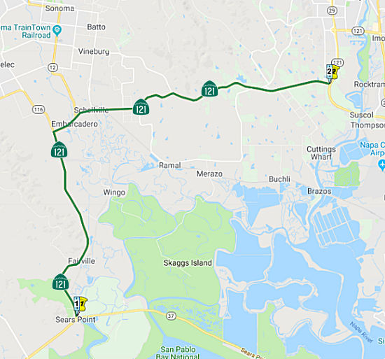 From Route 37 near Sears Point to Route 29 near Napa.
 Post 1964 Signage History
This segment is unchanged from its 1963 definition.
 Pre 1964 Signage History
Between the original signage of state routes in 1934 and 1964, this was part of Route 37. It was LRN 8, defined in 1909.
 In 1961, there was controversy regarding a proposed
freeway routing for Route 12 and Route 37 (today's Route 121) near Sonoma.
The State Highway engineer recommended the Modified P Route. This route
follows the existing highway from Sign Route 48 (now Route 37) to Sears
Point, passes W of the Schellville Airport and runs to the junction of
Sign Route 37 (now Route 121) and Route 12. That portion was not
contested. What was contested was the next portion, which runs W of Sonoma
from the site of A&B market, the N route, and the Sangiacomo Orchards
parallel to Watmaugh Rd to Arnold Dr., where it would veer N at an
interchange and run between Arnold Dr. and existing Route 12 to a point E
of Glen Ellen where it comes back to parallel the existing Route 12. There
was a large amount of opposition to this route. The freeway routing was
adopted. Later, in 1977, the CHC advertised for public comment regarding
rescinding the adoption of Route 12 and Route 121 in this area, from
Melita Road to the Sonoma/Napa County Line on Route 12, and from Sonoma to
Sears Point on Route 121. The rescinding seems to have been approved, for
as of 2023, the routing is still the original non-freeway routing through
Sonoma.
In 1961, there was controversy regarding a proposed
freeway routing for Route 12 and Route 37 (today's Route 121) near Sonoma.
The State Highway engineer recommended the Modified P Route. This route
follows the existing highway from Sign Route 48 (now Route 37) to Sears
Point, passes W of the Schellville Airport and runs to the junction of
Sign Route 37 (now Route 121) and Route 12. That portion was not
contested. What was contested was the next portion, which runs W of Sonoma
from the site of A&B market, the N route, and the Sangiacomo Orchards
parallel to Watmaugh Rd to Arnold Dr., where it would veer N at an
interchange and run between Arnold Dr. and existing Route 12 to a point E
of Glen Ellen where it comes back to parallel the existing Route 12. There
was a large amount of opposition to this route. The freeway routing was
adopted. Later, in 1977, the CHC advertised for public comment regarding
rescinding the adoption of Route 12 and Route 121 in this area, from
Melita Road to the Sonoma/Napa County Line on Route 12, and from Sonoma to
Sears Point on Route 121. The rescinding seems to have been approved, for
as of 2023, the routing is still the original non-freeway routing through
Sonoma.
(Source: Press Democrat, 9/28/1961, via Joel Windmiller, 2/1/2023;
Press Democrat, 2/3/1977 via Joel Windmiller, 2/23/2023)
 Status
State Route 37/121 Operational Improvement Project (04-Son-37, PM 3.8/4.3)
 The 2020 SHOPP, approved in May 2020, included the following NEW Mobility item of
interest: 04-Sonoma-37 PM 3.8/4.0 PPNO 2023H Proj ID 0418000281 EA 1Q480.
Route 37 near Novato, at the intersection with Route 121. Improve
traffic operations by modifying intersection. Programmed in FY23-24, with
construction scheduled to start in September 2024. Total project cost is
$11,241K, with $6,533K being capital (const and right of way) and $4,708K
being support (engineering, environmental, etc.).
The 2020 SHOPP, approved in May 2020, included the following NEW Mobility item of
interest: 04-Sonoma-37 PM 3.8/4.0 PPNO 2023H Proj ID 0418000281 EA 1Q480.
Route 37 near Novato, at the intersection with Route 121. Improve
traffic operations by modifying intersection. Programmed in FY23-24, with
construction scheduled to start in September 2024. Total project cost is
$11,241K, with $6,533K being capital (const and right of way) and $4,708K
being support (engineering, environmental, etc.).
(Source: 2020 Approved SHOPP a/o May 2020)
In May 2023, the CTC approved for future consideration
of funding the following project for which a Final Environmental
Impact Report (FEIR) has been completed: Route 37 in Sonoma County
(04-Son-37, PM 3.8/4.3). Improve traffic operations by modifying the Route 37 and Route 121 intersection, in Sonoma County. (PPNO 2911K) This project
is located on Route 37 from postmile 3.8 to postmile 4.3, in Sonoma
County. The Department proposes to improve traffic operations by modifying
the Route 37 and Route 121 intersection. The project is currently
programmed in the 2022 State Highway Operation and Protection Program
(SHOPP) for a total of $26,446,000, which includes Right of Way (Support
and Capital) and Construction (Support and Capital). Construction is
estimated to begin 2024-25. The scope, as described for the preferred
alternative, is consistent with the project scope as programmed by the
Commission in the 2022 SHOPP.
(Source: May 2023 CTC Agenda, Agenda Item 2.2c.(9))
In March 2012, the CTC authorized SHOPP funding on Route 121 04-Son-121 3.4/6.5 Near Sonoma, within the San Francisco Bay Trail (PM 3.4/6.5 and PM 8.6/11.6) on Route 121. $350,000 to install centerline rumble strips to reduce the number of cross-centerline collisions and improve safety.
Schellville Collision Reduction Project (04-Son-121, PM 3.36/6.50)
In March 2019, the CTC approved for future
consideration of funding a project located on Route 121 near the community
of Schellville in Sonoma County (04-Son-121, PM 3.36/6.50). The project
proposes to reduce the occurrences of cross-centerline and rear-end
collisions on this portion of roadway. The proposed project will also
widen shoulders, upgrade curves, add two way left turn lanes at various
locations, and install rumble strips. The project proposes to address the
higher than statewide average of cross centerline accidents and fatalities
at this project location during a five-year period (Two and Three Lane
Safety Monitoring Report). This project is fully funded and programmed in
the 2018 SHOPP for approximately $43.5 million. Construction is estimated
to begin in Fiscal Year 2019-20. The scope, as described for the preferred
alternative, is consistent with the project scope programmed by the
Commission in the 2018 SHOPP.
(Source: March 2019 CTC Minutes, Agenda Item 2.2c.(1);March2019
CTC Minutes Agenda Item 2.1a.(1) Amendment Item 3)
In January 2022, the CTC amended the SHOPP to delete
this project: 04-Son-121 PM 3.4/6.5. PPNO 04-0738; ProjID
0400020007; EA 0G680. Route 121 Near Schellville, from north of Tolay
Creek Bridge to south of Yellow Creek Bridge. Widen for standard
shoulders, upgrade curves to standard, extend two-way left turn lane,
and install rumble strips. Note: Delete project. The
collisions in the area have reduced as a result of rumble strips and High
Friction Surface Treatment (HFST) installed under other projects.
(Source: January 2022 CTC Agenda, Agenda Item
2.1a.(1d) #5)
In June 2018, it was reported that Caltrans is
holding community meetings to discuss a coming safety improvement project
on Route 121 between Wagner and Bisso roads, south of the Bonneau Rd.
intersection past Cornerstone and Viansa Winery. The project proposes to
reduce accidents and improve safety by implementing safety measures, such
as widening shoulders, realigning the roadway and adding a center-turn
lane where necessary. The project is immediately south of the Bonneau
intersection of Route 121 (Fremont Drive) and Route 116 (Arnold Drive) (~
SON 6.622) known as Big Bend. That intersection has been studied by the
Sonoma County Transit Authority and Caltrans to install a hybrid multilane
roundabout, currently in its final planning stages. The environmental
document will be finalized in Fall 2018.
(Source: Sonoma Index-Tribune, 5/28/2018)
Route 116/Route 121 Roundabout (04-Sonoma-121 PM 6.5/7.0)
 In December 2014, it was reported that the state is moving ahead with plans that call for a
possible two-lane roundabout or traffic signal at the intersection of
Route 116 and Route 121. Officials are still assessing environmental and
other impacts, such as a noise, for both options before they can move
ahead with designs. They’re also meeting with business and vineyard
owners, who could see some encroachment if a roundabout is built. If
approved, construction could start around 2019-2020. It’s taken so
long to deal with the crossing at Route 116 and Route 121 in part because
of the number of government agencies involved. The plans also call for
sidewalks up to 10 feet wide, which would accommodate both pedestrians and
bicyclists. An existing park-and-ride lot could be relocated and the
nearby bridge over Yellow Creek replaced.
In December 2014, it was reported that the state is moving ahead with plans that call for a
possible two-lane roundabout or traffic signal at the intersection of
Route 116 and Route 121. Officials are still assessing environmental and
other impacts, such as a noise, for both options before they can move
ahead with designs. They’re also meeting with business and vineyard
owners, who could see some encroachment if a roundabout is built. If
approved, construction could start around 2019-2020. It’s taken so
long to deal with the crossing at Route 116 and Route 121 in part because
of the number of government agencies involved. The plans also call for
sidewalks up to 10 feet wide, which would accommodate both pedestrians and
bicyclists. An existing park-and-ride lot could be relocated and the
nearby bridge over Yellow Creek replaced.
(Source: Press-Democrat, 12/21/2014; Image source: Adapted from Sonoma County Gazette, 5/15/2020)
The 2020 SHOPP, approved in May 2020, included the
following NEW Mobily item of interest: 04-Sonoma-121 PM 6.5/7.0 PPNO 2031J
Proj ID 0412000557 EA 3G900. Route 121 near Schellville, at the
intersection of Routes 121 and 116. Construct roundabout. Programmed in
FY22-23, with construction scheduled to start in March 2023. Total project
cost is $18,869K, with $16,819K being capital (const and right of way) and
$2,050K being support (engineering, environmental, etc.).
(Source: 2020 Approved SHOPP a/o May 2020)
In May 2020, it was reported that CTC approved the
2020 SHOPP, which included funding in the amount of $19M to complete
improvements at the intersection of Route 116 and Route 121 southwest of
the City of Sonoma. The money will become available in 2022. Measure M,
the ¼-cent sales tax for transportation, was used to leverage the
state dollars in order to fully fund the improvements. Measure M is
contributing $5M. The project will improve traffic circulation and safety
for all users and reduce congestion by removing the current stop
sign-controlled intersection and installing a roundabout at the
intersection of Highway 121 and 116. The project will also widen the
roadway to allow for turn lanes into and out of existing commercial uses.
The Park and Ride lot will be relocated; the parking capacity will remain
the same in the new location. SCTA serves as the project sponsor and
Caltrans will build the project. The current cost estimate for this
project is $24 million, and construction is currently scheduled to start
in early 2023. The environmental documentation for compliance with the
National Environmental Protection Act / California Environmental Quality
Act (NEPA/CEQA) and project approval was completed in April 2018. Design
and right of way phases are underway and will be completed by 2022.
(Source: Sonoma County Gazette, 5/15/2020)
The roundabout is part three of a five-part Sonoma
County Transportation Authority 'local streets' project to improve traffic
conditions along Arnold Drive (Route 116, and continuation of the street N
of the point Route 116 turns off onto Stage Gulch Road), funded by Measure
M, the quarter-cent sales tax for transportation improvements passed by
county voters in 2004. The first part of the Arnold Drive project was
widening the two-lane road's shoulders just south of Glen Ellen (off the
state highway system, near Route 12), which was completed in 2012. The
second part was the Hap Arnold Roundabout at the intersection of Agua
Caliente Road (off the state highway system), completed in 2014. Note that
the SHOPP grant for this project won't become available until 2022, when
Sonoma County Transportation Authority supplies the additional $5 million
in sales tax revenues to reach the $24 million mark. The project approval
and environmental review were finished in spring 2018, setting up design
of the roundabout and negotiating for adjacent property by 2022, when the
state funding will be available. Construction is expected to begin in
early 2023 and completed by the end of 2024.
(Source: Sonoma Index Tribune, 5/18/2020)
In March 2023, the CTC approved for future
consideration of funding the following project for which a MND has been
completed: Route 116 and Route 121 in Sonoma County. Improve
operations for vehicles, bicycles, and pedestrians where Route 116 and
Route 121 intersect, consequently reducing congestion and the occurrence
of accidents, in Sonoma County. (PPNO 2031J) The project is located on
Route 116 from postmile 46.0 to 46.7, and on Route 121 from postmile 5.8
to R7.4, in Sonoma County. The Department proposes to improve traffic
operations at the Route 116/Route 121 intersection in the unincorporated
area of Sonoma County. The project will construct a roundabout at this
intersection and include widening of Route 116, Route 121, and Bonneau
Road, construct pedestrian facilities, remove an existing free right-turn
from northbound Route 121 to eastbound Route 121, and relocate an existing
park and ride lot. The project is currently programmed in the 2022 SHOPP
for a total of $18,869,000 which includes Right of Way (capital) and
Construction (support and capital). Construction is estimated to begin
2022-23. The scope, as described for the preferred alternative, is
consistent with the project scope as programmed by the Commission in the
2022 SHOPP.
(Source: March 2023 CTC Agenda, Agenda Item 2.2c.(1))
In March 2023, the CTC approved the following amendment
to the 2022 SHOPP: 04-Son-121 6.5/7.0. PPNO 04-2031J; ProjID 0412000557;
EA 3G900. Route 121 Near Schellville, at the intersection of Route 121 and
Route 116. Construct roundabout. Additional contribution of
$602,000 for R/W Cap from the Sonoma County Transportation Authority
(SCTA). Concurrent CONST and CON ENG allocation under Resolution FP-22-56;
March 2023. Note: Split plant establishment and environmental monitoring
work into project EA 3G901/PPNO 04-2917W from parent project EA 3G900/PPNO
04-2031J. Update description to include contribution by the local
transportation authority. Allocation ($ × 1,000): PA&ED $0;
PS&E $0; R/W Sup $0; Con Sup $2,050; R/W Cap $4,331; Const Cap $12,400
$11,538; TOTAL $18,869 $17,919. FY22-23
(Source: March 2023 CTC Agenda, Agenda Item 2.1a.(1d) #3)
In March 2023, the CTC approved the following
construction/construction support phase SHOPP allocation: $15,792,000.
04-Son-121 6.5/7.0. PPNO 04-2031J; ProjID 0412000557; EA 3G900. Route 121
Near Schellville, at the intersection of Route 121 and Route 116.
Outcome/Output: Construct roundabout to improve operations, reduce
congestion, and improve safety. (Additional contribution of $602,000 for
R/W Cap from the Sonoma County Transportation Authority (SCTA)). CEQA -
MND, 4/4/2018; Re-validation 1/26/2023 NEPA - FONSI, 4/4/2018;
Re-validation 1/26/2023. Concurrent consideration of funding under
Resolution E-23-24; March 2023. As part of this allocation request, the
Department is requesting to extend the completion of CONST and CON ENG an
additional 12 months beyond the 36 month deadline. Concurrent Amendment
under SHOPP Amendment 22H-007; March 2023. Allocation: CON ENG $2,050,000;
CONST $12,488,000.
(Source: March 2023 CTC Agenda, Agenda Item 2.5b.(1) #14)
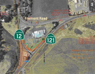 In 2012, the intersection of Route 12 and Route 121
(04-SON-121 PM 007.45) was reconfigured. Prior to 2012, the intersection
had a number of angular junctions. After reconstruction, the intersection
of Route 12 and Route 121 was a traditional T-interchange, with nearby
Fremont road being turned into a westbound only spur. The changes were
prompted by an higher-than-average accident rate at the intersection. The
cost of the project is $2.4 million.
In 2012, the intersection of Route 12 and Route 121
(04-SON-121 PM 007.45) was reconfigured. Prior to 2012, the intersection
had a number of angular junctions. After reconstruction, the intersection
of Route 12 and Route 121 was a traditional T-interchange, with nearby
Fremont road being turned into a westbound only spur. The changes were
prompted by an higher-than-average accident rate at the intersection. The
cost of the project is $2.4 million.
Huichica Creek bridge project (04-NAP-121 0.5/1.0)
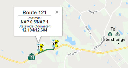 In November 2017, there was an update on the $13.9 million Huichica Creek bridge project
(04-NAP-121 PM 0.75), which could begin construction in 2020 and last for
two years. The stated goals are to make the highway safer for motorists
and to make the creek easier to navigate for fish. Caltrans intends to
demolish an old bridge, build a new one and still allow an average of
32,000 vehicles daily to keep crossing the creek under Route 121, which is
also known as Route 12 and the Carneros Highway. The idea is to do the
project in phases, with the new bridge overbuilt initially and the extra
width removed during the last phase. Traffic will shift as a section of
the new bridge is built and a section of the old bridge is removed. A new
Huichica Creek bridge will be the final piece of a bigger project that
improved virtually all of a 1.7-mile stretch from Duhig Road in Napa
County to the Sonoma County line. Caltrans didn’t replace the
Huichica Creek bridge along this stretch of Route 121 to fit in with the
rest of the wider roadway. The reason was proposed fish passage
improvements associated with the proposed bridge didn’t satisfy
various state and federal environmental agencies. Huichica Creek flows for
about 16 miles from the southern Mayacamas mountains to Napa Slough, which
empties into the Napa River. Steelhead trout are in the stream. The state
Department of Fish and Wildlife considers the portion of the creek at the
bridge to be a fish barrier to upstream spawning grounds. Downstream of
the bridge is a six-foot to eight-foot drop that fish have trouble
passing. The creek crosses under the bridge in three 78-inch-wide metal
culverts built in 1968, when environmental laws were laxer. The
new-and-improved Huichica Creek bridge would have no culverts, but would
be a free span bridge clear of the creek. Caltrans proposes to remove
paved portions of the creek channel near the bridge, create a gentler
slope in the channel and build eight step-pools that fish could travel
between with a maximum half-foot jump. Fish passage improvements are to
extend 300 feet downstream of the bridge and 130 feet upstream. The new
bridge will even allow more light to penetrate to the bottom of the creek.
That should allow for natural physical and biotic conditions.
In November 2017, there was an update on the $13.9 million Huichica Creek bridge project
(04-NAP-121 PM 0.75), which could begin construction in 2020 and last for
two years. The stated goals are to make the highway safer for motorists
and to make the creek easier to navigate for fish. Caltrans intends to
demolish an old bridge, build a new one and still allow an average of
32,000 vehicles daily to keep crossing the creek under Route 121, which is
also known as Route 12 and the Carneros Highway. The idea is to do the
project in phases, with the new bridge overbuilt initially and the extra
width removed during the last phase. Traffic will shift as a section of
the new bridge is built and a section of the old bridge is removed. A new
Huichica Creek bridge will be the final piece of a bigger project that
improved virtually all of a 1.7-mile stretch from Duhig Road in Napa
County to the Sonoma County line. Caltrans didn’t replace the
Huichica Creek bridge along this stretch of Route 121 to fit in with the
rest of the wider roadway. The reason was proposed fish passage
improvements associated with the proposed bridge didn’t satisfy
various state and federal environmental agencies. Huichica Creek flows for
about 16 miles from the southern Mayacamas mountains to Napa Slough, which
empties into the Napa River. Steelhead trout are in the stream. The state
Department of Fish and Wildlife considers the portion of the creek at the
bridge to be a fish barrier to upstream spawning grounds. Downstream of
the bridge is a six-foot to eight-foot drop that fish have trouble
passing. The creek crosses under the bridge in three 78-inch-wide metal
culverts built in 1968, when environmental laws were laxer. The
new-and-improved Huichica Creek bridge would have no culverts, but would
be a free span bridge clear of the creek. Caltrans proposes to remove
paved portions of the creek channel near the bridge, create a gentler
slope in the channel and build eight step-pools that fish could travel
between with a maximum half-foot jump. Fish passage improvements are to
extend 300 feet downstream of the bridge and 130 feet upstream. The new
bridge will even allow more light to penetrate to the bottom of the creek.
That should allow for natural physical and biotic conditions.
(Source: Napa Valley Register, 11/6/2017)
The following project was included in the final adopted 2018 SHOPP in March 2018: PPNO 0775G. 04-Napa-121 0.5/1.0. Route 121 Near Napa, at Huichica Creek (PM 0.75). Roadway widening. Begin Con: 7/17/2020. Total Project Cost: $20,469K.
In June 2018, the CTC approved for future
consideration of funding the following project: 04-Nap-121, PM 0.5/1.0
Huichica Creek Bridge Replacement & Fish Passage Project: Replace
existing bridge and make improvements to an existing fish passage on Route 121 in Napa County. (MND) (PPNO 0775G) (SHOPP). This project is located on
Route 121 over Huichica Creek near the city of Napa in Napa County. The
project proposes to widen Route 121 over Huichica Creek, remove existing
culverts and replace with a free span bridge. The project also incorporate
fish passage improvements along Huichica Creek. The proposed project will
also reduce crosscenterline and run-off-the road accidents and restore
creek banks along Huichica Creek. This proposed project is estimated to
cost a total of $22.5 million. The project is funded for the first phase
of this project and is currently programmed in the 2018 SHOPP for
approximately $20.5 million which includes Construction (capital and
support) and Right of Way (capital and support). The project is estimated
to begin construction in 2020. The scope, as described for the preferred
alternative, is consistent with the project scope programmed by the
Commission in the 2018 SHOPP.
(Source: CTC Agenda, June 2018 Agenda Item 2.2c(1))
In October 2019, the CTC had on its agenda a
supplemental funding request for an additional $1,200,000 in Capital
Outlay Support (COS), for the Plans, Specifications and Estimate
(PS&E) phase for the Huichica Creek Bridge (04-NAP-121 0.5/1.0, PPNO
0775G Proj ID 0412000310 EA 4G210). This project is located on Route 121
near the City of Napa, in Napa County. The project will construct a
single-span bridge to replace the existing culvert at Huichica Creek
Bridge. The project also includes the accommodation of fish passage as
required by resource agencies. This bridge project is the second phase of
a two-phase, two-mile roadway widening/curve correction and a roadway
safety improvements project. The bridge work was separated from the
roadway work to avoid delays and provide time to conduct environmental
studies and address concerns regarding work in the creek and fish passage.
The Department is requesting supplemental funds in the amount of
$1,200,000 to complete the PS&E phase. This is because additional
resources will be needed to address requirements for habitat restoration
and fish passage mitigation from the California Department of Fish and
Wildlife (CDFW) and National Marine Fisheries Service (NMFS). To secure
the Incidental Take Permit (ITP) from CDFW and address concerns from NMFS,
additional efforts are necessary to complete hydraulic and geomorphic
analyses and develop a range of feasible design alternatives for fish
passage. The Department must modify the original bridge and footing
designs to accommodate the regrading of streambed slopes and minimize
creek channel scour. Because of the presence of various species, including
fairy shrimp, yellow legged frog and steelhead trout, it has been
particularly challenging to arrive at a consensus design that meets
current design and safety standards, protects and enhances environmental
resources and addresses permit requirements.
(Source: October 2019 CTC Agenda, Agenda Item
2.5e.(1))
In January 2021, the CTC was informed of the following
SHOPP Safety allocation under delegated authority: (3) #1. $15,196,000.
04-Nap-121 0.5/1.0. PPNO 04-0775G ProjID 0412000310 EA 4G210. Route 121
Near Napa, at Huichica Creek Bridge No. 21-0001 (PM 0.75).
Outcome/Output: Improve safety by widening roadway at Huichica Creek by
replacing the existing triple metal culverts with a free span bridge,
improve fish passage, and restore creek banks. This project will
provide continuity to the widening constructed under safety project EA
44420, and will reduce the number and severity of collisions. CON ENG
$3,000,000; CONST $12,247,000.
(Source: January 2021 CTC Agenda, Agenda Item
2.5f.(3) #1)
Carneros Intersection (04-Nap-121 PM 04.47)
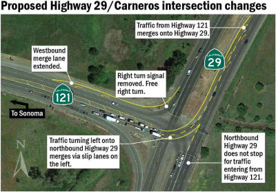 In July 2017, a new proposal emerged for the Carneros
Junction: Where Route 29 meets Route 12/Route 121 (04-Nap-121 PM 04.47).
No massive interchange is proposed to replace traffic signals at the
T-intersection for Napa and Sonoma flows. Instead, the three-year-old idea
is to add merge lanes, give some lanes a constant green light and reap a
little congestion relief. The NVTA took a close look at the Carneros
intersection in its 2014 Highway 29 Gateway plan. This study concluded an
interchange with on-ramps and off-ramps is the ultimate solution, but that
such a structure would be costly and could have big environmental impacts.
One alternative is building the Carneros interchange roundabout, either
with or without traffic signals. This wouldn’t make a big
congestion-easing difference in the long run, the plan concluded. That
leaves the $1 million idea to ease congestion on the (relative) cheap.
Northbound Route 29 traffic presently stops at a red light when Route 121
traffic coming from the Sonoma direction turns left toward Napa. The
proposed change – have northbound traffic always flowing through the
intersection. And what happens when the Highway 121 traffic makes a left
turn in front of it? A long merge lane would be created so these divergent
traffic streams have space to come together. The same concept would be
used so southbound Route 29 traffic turning right onto Route 121 toward
Sonoma could always have a green light. A long merge lane would be the
buffer when northbound Route 29 traffic makes a left turn onto Route 121.
This proposed project wouldn’t necessarily make Carneros
intersection a motorist’s paradise. There would still be a red light
during the southbound Route 29 morning commutes. The bigger, more
expensive project for the more congested Soscol Junction a few miles south
along Route 29 remains the NVTA’s priority. The agency and Caltrans
are working on that project’s environmental impact report. Still,
the smaller Carneros intersection project is at least in the
agency’s sights, even if there is no timeline to build it and no
state-required environmental report has yet been launched. If all had gone
as planned in the 1970s, both the Carneros and Soscol Junction
intersections would already be interchanges today. Caltrans during that
decade was figuring out the huge Southern Crossing project. Route 29 at
that point went north on Route 221 and then cut across the valley on Imola
Avenue. Route 29 then continued north up Napa Valley and Route 121 went
west to Sonoma. All of that led to congestion near Napa State Hospital and
on Imola Avenue. Caltrans and county officials wanted a Southern Crossing
bridge – today’s Butler Bridge – so Route 29 could
bypass the city of Napa several miles to the south. The Southern Crossing
project approved in 1974 included interchanges at both entrances. But in
1975, state transportation officials pleaded poverty and proposed
installing traffic signals instead. The state would return to build
interchanges “when traffic warrants them.” By 1977, the state
didn’t even have money to connect Route 29 to the bridge it was
already building over the Napa River. County officials went from worrying
about having interchanges to keeping the Southern Crossing from becoming a
bridge to nowhere. In 1981, the state finally opened the several miles of
connecting highway that made the Butler Bridge part of Route 29. But the
interchanges had dropped from the plans, replaced by the traffic signals.
In July 2017, a new proposal emerged for the Carneros
Junction: Where Route 29 meets Route 12/Route 121 (04-Nap-121 PM 04.47).
No massive interchange is proposed to replace traffic signals at the
T-intersection for Napa and Sonoma flows. Instead, the three-year-old idea
is to add merge lanes, give some lanes a constant green light and reap a
little congestion relief. The NVTA took a close look at the Carneros
intersection in its 2014 Highway 29 Gateway plan. This study concluded an
interchange with on-ramps and off-ramps is the ultimate solution, but that
such a structure would be costly and could have big environmental impacts.
One alternative is building the Carneros interchange roundabout, either
with or without traffic signals. This wouldn’t make a big
congestion-easing difference in the long run, the plan concluded. That
leaves the $1 million idea to ease congestion on the (relative) cheap.
Northbound Route 29 traffic presently stops at a red light when Route 121
traffic coming from the Sonoma direction turns left toward Napa. The
proposed change – have northbound traffic always flowing through the
intersection. And what happens when the Highway 121 traffic makes a left
turn in front of it? A long merge lane would be created so these divergent
traffic streams have space to come together. The same concept would be
used so southbound Route 29 traffic turning right onto Route 121 toward
Sonoma could always have a green light. A long merge lane would be the
buffer when northbound Route 29 traffic makes a left turn onto Route 121.
This proposed project wouldn’t necessarily make Carneros
intersection a motorist’s paradise. There would still be a red light
during the southbound Route 29 morning commutes. The bigger, more
expensive project for the more congested Soscol Junction a few miles south
along Route 29 remains the NVTA’s priority. The agency and Caltrans
are working on that project’s environmental impact report. Still,
the smaller Carneros intersection project is at least in the
agency’s sights, even if there is no timeline to build it and no
state-required environmental report has yet been launched. If all had gone
as planned in the 1970s, both the Carneros and Soscol Junction
intersections would already be interchanges today. Caltrans during that
decade was figuring out the huge Southern Crossing project. Route 29 at
that point went north on Route 221 and then cut across the valley on Imola
Avenue. Route 29 then continued north up Napa Valley and Route 121 went
west to Sonoma. All of that led to congestion near Napa State Hospital and
on Imola Avenue. Caltrans and county officials wanted a Southern Crossing
bridge – today’s Butler Bridge – so Route 29 could
bypass the city of Napa several miles to the south. The Southern Crossing
project approved in 1974 included interchanges at both entrances. But in
1975, state transportation officials pleaded poverty and proposed
installing traffic signals instead. The state would return to build
interchanges “when traffic warrants them.” By 1977, the state
didn’t even have money to connect Route 29 to the bridge it was
already building over the Napa River. County officials went from worrying
about having interchanges to keeping the Southern Crossing from becoming a
bridge to nowhere. In 1981, the state finally opened the several miles of
connecting highway that made the Butler Bridge part of Route 29. But the
interchanges had dropped from the plans, replaced by the traffic signals.
(Source: Napa Valley Register, 7/15/2017)
 Naming
Route 121 from Route 37 to Route 29 in Sonoma and Napa Counties is named the "Carneros Highway". The road is named for the wine-growing region south of the Napa Valley. Carneros refers to the area's cattle ranching history. Named by Senate Concurrent Resolution 62, Chapter 29 in 1992. Note that route is called "Arnold Drive" between Route 116 and Route 37, at least as far as residents and the post office is concerned.
The portion of this route running through Sonoma County is called the "Valley of the Moon Scenic Route". "Valley of the Moon" was the name Jack London, resident of Glen Ellen, coined for this area.
Historically, this route is close to the original "El Camino Real" (The Kings Road). A portion of this route has officially been designated as part of "El Camino Real by Assembly Bill 1707, Chapter 739, on October 11, 2001.
 Scenic Route
 From Route 29 in Napa to Route 128.
Post 1964 Signage HistoryIn 1963, this segment was defined as "(b) Route 29 near Napa State Hospital to Route 128."
In 1984, Chapter 409 changed the definition to originate as "Route 29 in Napa" The portion from Route 29 in Napa to Route 29 [now Route 221] near Napa State Hospital was transferred from Route 29. This was a side effect of the opening of the new Route 29 freeway. This bypassed the older segment of Route 29 than ran from Suscol Ave N to Imola (State Hospital), and then along Imola to Solano Avenue. The bypassed segment was split between Route 221 (Route 29 to Imola, the number coming from a deleted bypass N of Napa) and Route 121 (State Hospital along Imola to Solano (Route 29)).
Pre 1964 Signage HistoryBetween the original signage of state routes in 1934 and 1964, this was signed as part of Route 37. It was part of the 1933 extension of LRN 6.
Status In August 2020, it was reported that the Napa Valley Transportation Authority (NVTA) has just
released the draft Imola Corridor Complete Streets Improvement Plan, with
a goal of creating a better Imola Avenue through Napa (~NAP R4.533 to NAP
R5.883). Once the vision is finalized, transportation officials will seek
money to make it a reality. The 3.5-mile-long street, a section of which
is Route 121, is a hodgepodge of eras, looks and neighborhoods. Some parts
have sidewalks, others don’t. One section passes homes, another
bustling shopping centers, another vineyards, another the oak-covered
hills of Skyline Wilderness Park. The goal is to transform car-centric
Imola Avenue into a road that also emphasizes walking, cycling and mass
transit. Estimated cost is $14.3 million. Among the proposed pedestrian
improvements is adding curb extensions at busy intersections to lessen
crossing distance. Sidewalk gaps would be filled in. Eye-catching
crosswalks with multiple pavement lines would be added. A system of bike
routes, protected bikeways and multi-use paths would go in. One feature is
creating “transit islands” for bus stops where buses stop in
the travel lane. These concrete islands for those boarding buses allow the
on-street bike lane to pass behind the bus stop, eliminating potential
conflicts between buses and cyclists. There is a variety of potential
funding sources, from the state Active Transportation Program to the local
Measure T sales tax to traffic impact fees to environmental mitigation.
Funding would be on a sub-project by sub-project basis. The draft
plan includes a benefit-cost analysis. This analysis seeks to put a money
value on such things as pedestrian and cyclist accidents avoided because
of the safer street and air pollution avoided because more people ride
bikes. Total benefits over 20 years would be $83 million, using Caltrans
benefit-cost methods. That compares to $14.3 million to build the projects
and another $2 million to maintain them over 20 years. The
benefit–cost value is 5.15:1. Not all of three Imola Road segments
are equal, though. The west segment from Foster Road to Jefferson Street
has benefit-cost ratio of almost 13.9-to-one; the Jefferson
Street-to-Soscol Avenue segment 2.76-to-one and the Soscol
Avenue-to-Fourth Avenue segment 1.82-to-one. Caltrans noted that the
agency is planning in 2024 to start repaving Route 121 from Route 29 to
Vichy Avenue near Silverado Trail. The cost is to be $32 million. Of those
more than five miles, about 1.3 miles is along Imola Avenue. Go to https://www.imolacorridorplan.org/ to see the draft Imola Avenue Corridor plan.
In August 2020, it was reported that the Napa Valley Transportation Authority (NVTA) has just
released the draft Imola Corridor Complete Streets Improvement Plan, with
a goal of creating a better Imola Avenue through Napa (~NAP R4.533 to NAP
R5.883). Once the vision is finalized, transportation officials will seek
money to make it a reality. The 3.5-mile-long street, a section of which
is Route 121, is a hodgepodge of eras, looks and neighborhoods. Some parts
have sidewalks, others don’t. One section passes homes, another
bustling shopping centers, another vineyards, another the oak-covered
hills of Skyline Wilderness Park. The goal is to transform car-centric
Imola Avenue into a road that also emphasizes walking, cycling and mass
transit. Estimated cost is $14.3 million. Among the proposed pedestrian
improvements is adding curb extensions at busy intersections to lessen
crossing distance. Sidewalk gaps would be filled in. Eye-catching
crosswalks with multiple pavement lines would be added. A system of bike
routes, protected bikeways and multi-use paths would go in. One feature is
creating “transit islands” for bus stops where buses stop in
the travel lane. These concrete islands for those boarding buses allow the
on-street bike lane to pass behind the bus stop, eliminating potential
conflicts between buses and cyclists. There is a variety of potential
funding sources, from the state Active Transportation Program to the local
Measure T sales tax to traffic impact fees to environmental mitigation.
Funding would be on a sub-project by sub-project basis. The draft
plan includes a benefit-cost analysis. This analysis seeks to put a money
value on such things as pedestrian and cyclist accidents avoided because
of the safer street and air pollution avoided because more people ride
bikes. Total benefits over 20 years would be $83 million, using Caltrans
benefit-cost methods. That compares to $14.3 million to build the projects
and another $2 million to maintain them over 20 years. The
benefit–cost value is 5.15:1. Not all of three Imola Road segments
are equal, though. The west segment from Foster Road to Jefferson Street
has benefit-cost ratio of almost 13.9-to-one; the Jefferson
Street-to-Soscol Avenue segment 2.76-to-one and the Soscol
Avenue-to-Fourth Avenue segment 1.82-to-one. Caltrans noted that the
agency is planning in 2024 to start repaving Route 121 from Route 29 to
Vichy Avenue near Silverado Trail. The cost is to be $32 million. Of those
more than five miles, about 1.3 miles is along Imola Avenue. Go to https://www.imolacorridorplan.org/ to see the draft Imola Avenue Corridor plan.
(Source: Napa Valley Register, 10/5/2020; Image source: Imola Corridor Plan)
In 2004, a new bridge was constructed in South Napa over the Napa River.
Called the "Imola Avenue Bridge" (evidently, bridge 21-0108, 04-NAP-121 PM
R005.30), it will replace the "Maxwell Bridge" and was the site of a
collapse in November 2003 that killed four and injured four. The Maxwell
Bridge, built in 1949, was adequate in its day, but now it's a major
bottleneck for highway and river traffic and flood water. Four lanes of
Imola Avenue traffic are funneled into two lanes at the bridge. Big boats
have to give 72-hour notice so Caltrans can raise it. Pedestrians and
bicyclists are herded onto a narrow outrigger on the north side only. By
2005, there will be a $40 million replacement bridge allowing for four
lanes for motorists. There will be eight-foot lanes in each direction for
bicyclists and pedestrians. Boats will have a 60-foot clearance. And the
Napa Valley Wine Train will go under the eastern approach, not through it.
The design is as an elevated skyway, with a smooth, long arch over the
river, with more lighting and pedestrian-bicyclist facilities. Although a
Caltrans bridge, the project was put together by the city of Napa working
under a tight deadline so as to not delay the Napa River Flood Control
Project. Half of the new span will begin construction this month about 100
feet north of the Maxwell Bridge. By October 2004, traffic will be shifted
onto the two new lanes, the old bridge will be torn down and the final two
lanes built. Because the new span will be 1,700 feet long, rising 60 feet
over the river, it will eliminate a bottleneck that traps flood water. The
deck of the new bridge will be about as high as the bottom of the concrete
counterweights on the present bridge. Bridge Pictures.
(Source: Napa Valley Register, 4/12/2003)
State Route 121 Tulucay Creek Bridge Replacement Project (04-Nap-121, PM 6.4/6.5)
 The 2020 SHOPP, approved in May 2020, included the following NEW Bridge Preservation item
of interest: 04-Napa-121 PM 6.4/6.5 PPNO 1493C Proj ID 0416000041 EA
4J820. Route 121 in the city of Napa, at Tulocay Creek Bridge No. 21-0003
(PM 6.423). Replace existing bridge with a single span precast concrete
box girder bridge. Programmed in FY23-24, with construction scheduled to
start in February 2025. Total project cost is $32,972K, with $21,862K
being capital (const and right of way) and $11,110K being support
(engineering, environmental, etc.).
The 2020 SHOPP, approved in May 2020, included the following NEW Bridge Preservation item
of interest: 04-Napa-121 PM 6.4/6.5 PPNO 1493C Proj ID 0416000041 EA
4J820. Route 121 in the city of Napa, at Tulocay Creek Bridge No. 21-0003
(PM 6.423). Replace existing bridge with a single span precast concrete
box girder bridge. Programmed in FY23-24, with construction scheduled to
start in February 2025. Total project cost is $32,972K, with $21,862K
being capital (const and right of way) and $11,110K being support
(engineering, environmental, etc.).
(Source: 2020 Approved SHOPP a/o May 2020)
In May 2023, the CTC approved for future consideration
of funding the following project for which a MND has been completed: Route 121 in Napa County (04-Nap-121, PM 6.4/6.5). Replace the existing Tulucay
Creek Bridge with a single span precast concrete box girder bridge, in
Napa County. (PPNO 1493C) The project is located on Route 121 from
postmile 6.4 to postmile 6.5, in Napa County. The Department proposes to
replace the existing Tulucay Creek Bridge (Br. № 21-0003) with a
single span precast concrete box girder bridge. The project is currently
programmed in the 2022 SHOPP for a total of $32,972,000, which
includes Right of Way (Support and Capital) and Construction (Support and
Capital). Construction is estimated to begin 2024-25. The scope, as
described for the preferred alternative, is consistent with the project
scope as programmed by the Commission in the 2022 SHOPP.
(Source: May 2023 CTC Agenda, Agenda Item 2.2c.(1))
In May 2023, the CTC approved the following SHOPP (2a)
and SB1 (2b) allocation for preconstruction project phases for
environmental, design and R/W support: $5,092,000. 04-Nap-121 6.4/6.5.
PPNO 04-1493C; ProjID 0416000041; EA 4J820. Route 121 In the city of Napa,
at Tulocay Creek Bridge № 21-0003 (PM 6.423). Replace existing
bridge with a single span precast concrete box girder bridge. Concurrent
consideration of funding under Resolution E-23-54; May 2023. As part of
this allocation request, the Department is requesting to extend the
completion of the R/W Sup phase an additional 12 months beyond the 72
month deadline. PS&E $3,848,000; R/W Sup $1,050,000 (Programmed)
$1,244,000 (Allocated).
(Source: May 2023 CTC Agenda, Agenda Item 2.5b.(2b) #3)
In September 2023, it was reported that there are plans
to replace the Tulucay Creek Bridge № 21-0003. The 1918 bridge with
distinctive stone railing in the city of Napa is a workhorse. Caltrans
estimates that this section of Soscol Avenue north of South Napa
Marketplace handles almost 22,000 vehicles daily. The project will not
shut down Soscol Avenue in this busy area. Instead, Caltrans plans to keep
all four lanes of Soscol Avenue traffic flowing during the $33 million
project. The new bridge will be about 100 feet wide, as opposed to the
current 77 feet. That gives Caltrans wiggle room as it demolishes and
rebuilds the bridge in sections, first on one side, then the other and
then in the middle. Between what’s left of the old bridge at any one
time and sections of the new bridge as they get built, traffic lanes will
be juggled. Caltrans has looked at replacing this bridge since 1997 and
was set to start in 2002. That version of the project kept only two lanes
open during construction, with potential rush-hour delays of 55 minutes.
The city will be losing a bridge with some dash, in the opinion of the
city's 2003 Downtown Riverfront Urban Design Plan. It called the Tulucay
bridge “an attractive, little-noticed landmark.” They just
don’t make them like they did in 1918. Masons cut stones without
power tools and fitted them together. And, though the Tulucay bridge was
widened and modified in 1943, the stone railing remains. A Caltrans
environmental report called the stones "minor features" that are "easily
overlooked by highway users." Removing them wouldn't result in a
substantial visual change, it said. The new bridge will have see-through
bridge rails that will provide views of Tulucay creek presently blocked by
the stone rail.
(Source: Napa Valley Register, 9/12/2023)
Silverado Trail, 5-Way Intersection Improv (PPNO 0380N) (04-Napa-121 PM 7.2/7.4)
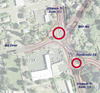 In February 2017, it was reported that years of
discussions about untying the five-way intersection at Silverado Trail,
Third Street, East Avenue and Coombsville Road (near 04-NAP-121 PM 9.047)
have been boiled down to a twin-roundabout plan just approved by the Napa
City Council. The pair of circular hubs is meant to keep drivers moving in
any direction, without the sharp turning angles and long waits at the
existing stoplight, while also improving safety for those on bicycle or
foot. The roundabouts were one of 13 proposed redesigns that were
scrutinized over the past three years by city engineers, state
transportation officials, and citizens who attended idea-gathering forums
on modernizing the five-way junction. Public works staff gave their
backing to a design that channels traffic into a four-way roundabout
connecting Silverado, East and Third to the north, and a three-leg
southern hub linking Silverado with Coombsville. That plan would require
fewer land takings than another two-roundabout design hooking Silverado,
Third and Coombsville into the south hub, which would have forced an
expensive realignment of Third Street, according to John Ferons, senior
civil engineer. City engineers rejected a single circle connecting all
five routes, as well as a design that would have consumed less land but
restricted East Avenue to right-turn entry and exit only. Napa’s
choice of a double roundabout will form the heart of a document it needs
for Caltrans to approve, design and complete the project. Caltrans is the
project’s final authority because Silverado Trail carries a section
of state Route 121. Napa and Caltrans, which oversees the part of
Silverado carrying state Route 121, are scheduled to draw up a project
study, environmental documents, plans and a final cost estimate by the
fall of 2021. Land acquisition is expected to continue to the end of that
year, with construction planned from June 2022 to October 2024.
In February 2017, it was reported that years of
discussions about untying the five-way intersection at Silverado Trail,
Third Street, East Avenue and Coombsville Road (near 04-NAP-121 PM 9.047)
have been boiled down to a twin-roundabout plan just approved by the Napa
City Council. The pair of circular hubs is meant to keep drivers moving in
any direction, without the sharp turning angles and long waits at the
existing stoplight, while also improving safety for those on bicycle or
foot. The roundabouts were one of 13 proposed redesigns that were
scrutinized over the past three years by city engineers, state
transportation officials, and citizens who attended idea-gathering forums
on modernizing the five-way junction. Public works staff gave their
backing to a design that channels traffic into a four-way roundabout
connecting Silverado, East and Third to the north, and a three-leg
southern hub linking Silverado with Coombsville. That plan would require
fewer land takings than another two-roundabout design hooking Silverado,
Third and Coombsville into the south hub, which would have forced an
expensive realignment of Third Street, according to John Ferons, senior
civil engineer. City engineers rejected a single circle connecting all
five routes, as well as a design that would have consumed less land but
restricted East Avenue to right-turn entry and exit only. Napa’s
choice of a double roundabout will form the heart of a document it needs
for Caltrans to approve, design and complete the project. Caltrans is the
project’s final authority because Silverado Trail carries a section
of state Route 121. Napa and Caltrans, which oversees the part of
Silverado carrying state Route 121, are scheduled to draw up a project
study, environmental documents, plans and a final cost estimate by the
fall of 2021. Land acquisition is expected to continue to the end of that
year, with construction planned from June 2022 to October 2024.
(Source: Napa Valley Register, 2/8/2017)
The 2018 STIP, approved at the CTC March 2018 meeting, appears to allocate $1.153M in FY21-22 for R/W acquisition for this project. The City of Napa has a page on the project, which notes: City staff conducted public outreach meetings, evaluated multiple alternatives and developed the design concepts analyzed in a Caltrans Project Study Report – Project Initiation Document (PID). The Draft PID document was presented to City Council for their consideration and recommendation of an alternative at the scheduled City Council meeting on February 7, 2017. Following the City Council meeting, Public Works staff delivered the Draft PID document to Caltrans. Caltrans will finalize the document and begin the design process. The PID document also provides the information necessary to make the project competitive for federal, state, and regional funding. The recommended alternative is a double-roundabout configuration with a 4-leg roundabout to the north to serve Third Street, Silverado Trail and East Avenue and a 3-leg roundabout to the south to serve Silverado Trail and Coombsville Road. This alternative design, known as “Option 5F” provides traffic access for all street approaches of the intersection. A single, larger hub hooking into all five streets would have required difficult excavation into the hillside where East Avenue and Coombsville Road converge. Meanwhile, another dual-roundabout plan joining the Trail with Third and Coombsville at its south hub would have boosted the cost to $12.7 million, and forced a realignment of Third Street that would have removed a commercial building that houses Pearson’s Appliance & TV and other businesses.
In March 2020, the CTC approved the 2020 STIP,
which moved the programmed funding of $1,153K for PPNO 0380N "Rt
121/Silverado Trail, 5-Way intersection improv (SHOPP)" from FY 21-22 to
FY23-24.
(Source: March 2020 CTC Agenda, Item 4.7, 2020 STIP
Adopted 3/25/2020)
The 2020 SHOPP, approved in May 2020, included the
following NEW Mobility item of interest: 04-Napa-121 PM 7.2/7.4 PPNO 1483B
Proj ID 0414000097 EA 0J890. Route 121 in the city of Napa, at the
intersection with Third Street/East Avenue/Coombsville Road. Construct
intersection improvements. Programmed in FY23-24, with construction
scheduled to start in February 2025. Total project cost is $3,900K, with
$2,300K being capital (const and right of way) and $1,600K being support
(engineering, environmental, etc.).
(Source: 2020 Approved SHOPP a/o May 2020)
In November 2023, it was reported that Napa city
officials have given the go-ahead on project approval and environmental
evaluation for a roundabout project that will eventually replace a
traffic-clogging five-way intersection east of downtown. The project to
replace the current crossing with two roundabouts linking the Silverado
Trail, Third Street, Coombsville Road and East Avenue first won City
Council approval in 2017. A partnership between the city and Caltrans, the
project was slated for a 2022 groundbreaking and 2024 completion, but work
was delayed in 2021. The city's public works director, Julie Lucido, said
at the time that funding took longer than the city and state expected, in
part because the price increased from the original projection of $8.2
million to between $11 million and $20 million. With this city approval,
the project is officially moving forward again. THe approval begins the
year-long project approval and environmental document phase. During that
time, staff will prepare studies and the environmental documents required
by the state and federal governments, which are necessary to bring the
project back to the City Council and eventually to groundbreaking. The
Silverado Trail overhaul will be the third major roundabout project
launched by the city in recent years, after the completion of the Route 29
triple roundabouts at First Street in 2020 and current construction on two
roundabouts at Soscol Junction slated for completion next year. The city
is moving to roundabouts for two reasons – to improve safety for all
modes of transportation, including those on bicycles, and increase the
level of service for all intersection users. The shape of roundabouts also
changes the kinds of collisions that commonly occur at them. A roundabout
reduces potential for head-to-head and T-bone collisions by a tremendous
amount. In roundabouts, you get more low-speed sideswipe accidents. The
amount of greenhouse gases emitted at a roundabout is also substantially
lower than at a traditional intersection, because when a car is idling, it
releases the most gases, and at a roundabout, the car usually does not
idle for more than a couple of seconds while waiting to enter.
(Source: $ Napa Valley Register, 11/1/2023)
In September 2023, it was reported that $1.5 million in new federal
funding has been obtained for a roundabout at the intersection of Route 121 and Eighth Street East (~ SON 8.118), which will replace the current
T-intersection. There will also be an accompanying bike lane. The $1.5
million in federal appropriation funds for Caltrans will go toward
acquiring environmental clearance and project design, which will be
matched by $375,000 in local funds. The intersection is an integral
transportation corridor in the Carneros wine region connecting Sonoma
Valley to downtown Napa in the east and toward Marin and San Francisco in
the west. The project is scheduled for completion by spring 2026,
according to Caltrans.
(Source: Sonoma Index Tribune, 9/1/2023)
Sarco Creek Bridge (04-NAP-121 PM 009.30)
In June 2016, the CTC approved for future consideration of funding a project in Napa County that will replace the existing Sarco Creek bridge on Route 121 near the city of Napa (04-NAP-121 PM 009.30). The project is programmed in the 2014 State Highway Operation and Protection Program. The total programmed amount is $19,077,000 for capital and support. Construction is estimated to begin in Fiscal Year 2016-17. The scope, as described for the preferred alternative, is consistent with the project scope programmed by the Commission in the 2014 State Highway Operation and Protection Program.
In June 2016, the CTC approved $5,419,000 for a project in Napa County near Napa, at Sarco Creek Bridge No. 21-0008 and Silverado Trail Road. Outcome/Output: Replace bridge to address scour critical issues, include standard shoulders on new bridge, make improvements to facilitate fish passage, and increase stream bed capacity to meet 100 year storm event needs. Concurrent Consideration of Funding under Resolution E-16-35; June 2016
In June 2019, it was reported that the Milliken Creek Bridge is again
intact, having recovered from a car wreck and an earthquake. Stephen
Simich put the finishing touch on the comeback for the historic bridge
while also honoring a pioneer-era founder of his own Napa Marble &
Granite Works. Simich restored the stone dedication plaque for the 1908
stone arch bridge at Trancas Street and Silverado Trail near the city of
Napa (near 121 NAP 9.431). The plaque had been dashed into pieces by the
August 2014 South Napa earthquake. The name of the bridge builder is
commemorated on the plaque – H.W. Wing. Wing and fellow stone mason
James Newman in 1878 founded Napa Marble & Granite Works. The Simich
family has operated the business located at Third Street and Coombsville
Road since 1946. The Milliken Creek Bridge has taken hard knocks in recent
years. In May 2014, a chain-reaction accident caused by a suspected drunk
driver shattered much of the bridge railing. Then the earthquake hit in
August 2014, dislodging and breaking the stone plaque. Napa County
reopened the bridge in September 2014 after putting temporary bracing and
concrete railing in place. Milliken Creek Bridge is one of Napa
County’s prized stone arch bridges from the late 1800s and early
1900s. The county has about 27 public masonry arch bridges remaining that
are 20 feet long or longer, according to Caltrans. Milliken Creek Bridge
is on the National Register of Historic Places.
(Source: Napa Valley Register, 6/25/2019)
In May 2016, it was reported that Route 121 is at least several months
and $5.5 million away from once again having both lanes open north of
Wooden Valley Road between Napa and Lake Berryessa (near 04-NAP-121 PM
16.039). A section of the northbound lane on the narrow, two-lane road
slipped a half-dozen feet during early March 2016 storms. The road
reopened on March 25 with temporary signals in place to alternate traffic
in the southbound lane. Caltrans design teams are working on repair plans
for the northbound lane, agency spokesman Vince Jacala said Wednesday. The
preliminary cost estimate for the project is $5.5 million. The stricken
northbound lane slipped 6 or 7 feet below the southbound lane, with a
temporary concrete rail now separating them. Caltrans in late March
installed metal beams and built a retaining wall to prevent further
erosion. This section Route 121 handles an average of 1,800 autos daily.
By contrast, the section of Route 121 in Napa that is central Imola Avenue
handles 27,000 vehicles daily, according to Caltrans. But Route 121 near
Circle Oaks is the key link between rural communities near Lake Berryessa
and the city of Napa. Circle Oaks has about 180 homes and Berryessa
Highlands has about 350 homes.
(Source: Napa Valley Register, 5/1/2016)
Capell Creek Bridge Repair (Bridge № 21-0009, 04-NAP-121, PM 020.29)
In December 2011, the CTC approved for future consideration of funding a project in Napa County that will replace the Capell Creek Bridge (Bridge Number 21-0009) on Route 121 [04-NAP-121, PM 020.29]. The project is programmed in the 2010 State Highway Operation and Protection Program (SHOPP). The total estimated project cost is $10,880,000 for capital and support. Construction is estimated to begin in Fiscal Year 2012-13. The scope, as described for the preferred alternative, is consistent with the project scope programmed by the Commission in the 2010 SHOPP. A copy of the MND has been provided to Commission staff. The project will mitigate potential impacts to aesthetics to a less than significant level. Potential impacts to the vegetation in the project area will be mitigated through hydro-seeding with appropriate plant species. Oak trees removed will be replaced at a 3:1 ratio. Non-native trees will be replaced at a 1:1 ratio. Potential impacts to aesthetics will be mitigated by requiring the new bridge railing to have a finish pattern, surface texture, and coloration that mimic the original railing.
In June 2021, it was reported that Caltrans has started
work on a four-month long project to repair a century-old bridge along
Route 121. The work along Route 121, which is also known in the area as
Monticello Road, will contribute to the preservation of the Capell Creek
Bridge, whose original construction dates to 1907. The work will take
place between Circle Oaks Drive and Longhorn Ridge Road. The project will
consist of repairing cracks, road breaks and replacing the northwest
wingwall. The repair work requires crews to shift traffic for both
directions of travel into a single northbound or southbound lane depending
on the construction stages. A one-way traffic signal system and temporary
concrete barriers are being used to guide traffic into one lane for use by
both directions of travel during the construction work. Bicyclists are
sharing the main traffic lanes with vehicular traffic within the project
limits.
(Source: Local News Matters, 6/24/2021)
Naming Named Structures
Bridge 21-0075, at Imola Avenue in Napa, was named the "George M. Francis
Memorial Bridge". It was built in 1932, and was dedicated in May,
1932. George M. Francis was the editor of the Napa Register beginning in
1872. In 1889 he called a town meeting in Napa and organized the town's
first city government. It appears to have since been bypassed, but could
be bridge 21-0086, NAP R004.47).
[Information from Napa Chamber of Commerce, found
by Phillip Pacier]
In South Napa is the Maxwell Bridge. It was named in honor of nurseryman Thomas Maxwell, longtime
Napa County Supervisor (1917 to 1948) and Napa County's first
representative on the board of directors of the Golden Gate Bridge
District. This bridge is being replaced by the Imola Avenue Bridge,
and is being renamed the New Maxwell Bridge. This bridge will have
plaques for 1) Mr. Maxwell, and 2) the Lodi construction worker who was
killed during the building of the new structure late in 2003. It appears
to be Bridge 21-0108 (NAP R005.30)
[Information from a Napa Valley Register history
article by Louis Ezettie, dated December 3, 1988, page 7-A]
Pre 1964 Signage HistoryRoute 121 was not defined as part of the initial state signage of routes in 1934. It is unclear what (if any) route was signed as Route 121 between 1934 and 1964.
 Freeway
[SHC 253.1] Entire route. Added to the Freeway and Expressway system in 1959.
 Other WWW Links
 Statistics
Overall statistics for Route 121:
 Pre-1964 Legislative Route
In 1933, Chapter 767 added the route from "[LRN 32] W of Los Banos to Fresno-Tracy West Side Highway near Centinella" to the highway system. In 1935, this was defined as LRN 121 in the highway code with the definition:
In 1961, Chapter 1268 changed the terminus to simply "[LRN 41]".
This was an unsigned segment connecting Route 152 to Route 33. It is part of present day Route 33.
© 1996-2020 Daniel P. Faigin.
Maintained by: Daniel P. Faigin
<webmaster@cahighways.org>.
 Route 120
 Route 122