
 California Highways:
Click here for a key to the symbols used. An explanation of acronyms may be found at the bottom of the page.
 Routing
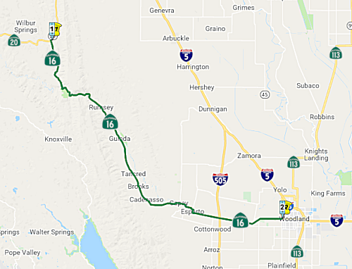 Route 20 to Route 5 near Woodland via Rumsey and Woodland.
 Post 1964 Signage History
This segment is as defined in 1963.
 Pre 1964 Signage History
In 1934, Route 16 was signed from Jct. Route 20 near Wilbur Springs to Jackson via Sacramento. It was LRN 50. It ran between Route 20 (LRN 15) and US 99W (LRN 7). Circa 1935, Route 16 was under construction between Route 20 and Rumsey. The portion between Route 20 and Rumsey was added in the third bond issue in 1919; the portion between Rumsey and Woodland was added in 1933.
 The specific Yolo County
chronology is as follows:
The specific Yolo County
chronology is as follows:
Nathan Edgars looked at traffic counts, and came up with the following:
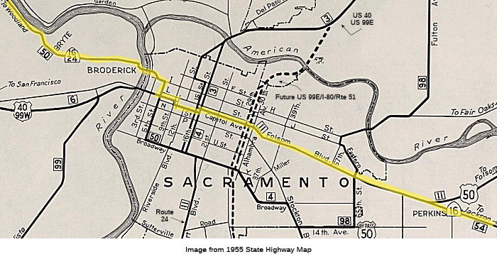
Route 80: Tower Bridge, over Capitol/N to 29th-30th, then a break to Broadway at 29th-30th and up 29th-30th
Route 99: from the south to Broadway, then west on Broadway, then a break to the east end of the I Street Bridge and up Jibboom Street
Route 16 cut back to I-5 at the east end of the I Street Bridge
Route 99 removed from P and Q Streets and instead routed back west on Broadway, replacing Route 16, but only to Route 275, where it broke until Jibboom Street
Note: The Gribblenation Blog, "Highways in and around Old Sacramento; US 40, US 99W, CA 16, CA 24, CA 70, CA 99, CA 275, and more" provides a detailed history of the various highways (US 40, US 99, Route 16, Route 24, Route 70, Route 99, Route 275, Route 51, I-5, and I-80 in the Old Sac area.
I-Street Bridge
Over on AAroads, Sparker noted the following about the I-Street routing: The original LRN 232 (after 1958 signed as Route 24) diverged from LRN 50/Route 16 at the intersection of the I Street extension bridge immediately east of the Sacramento River swing-span (shared with UP/former SP tracks on the lower/ground level deck) and Jibboom Street (both are elevated over the RR tracks). It headed north on Jibboom over a through-truss bridge crossing the American River; the street ended at Garden Highway -- atop the river levee --, at which point LRN 232/Route 24 turned west. About a mile west of there, the state highway diverged from Garden Highway along a broad arc descending north from the levee onto El Centro Avenue, which it utilized north into Sutter County. LRN 232 and Route 24 terminated at LRN 3/US 99E at a diamond interchange in Olivehurst.
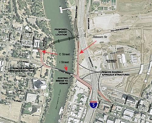 In October 2018, it was reported that the City of
Sacramento and Caltrans have initiated a project that will replace the
historic I-Street Bridge (for vehicular traffic) and the Jibboom Street
approach to the bridge for a new vehicular continuation of Railyards Blvd.
to C Street. The I Street Bridge is 100 years old (and is a former routing
of Route 16, Route 24, US 40, and US 99) and the lanes are too narrow to
serve buses, there are no bicycle lanes, and sidewalks are too narrow to
meet accessibility standards. The I Street Bridge and the four associated
approach structures are on the eligible bridge list for federal funds for
replacement and/or rehabilitation through the Highway Bridge Program
(HBP). The I Street Bridge has been classified as functionally obsolete,
and the existing approach structures have been classified as structurally
deficient. The I Street Bridge Replacement project will include
construction of a new bridge upstream of the existing I Street Bridge. The
new bridge will cross the Sacramento River between the Sacramento
Railyards and the West Sacramento Washington planned developments and
provide a new bicycle, pedestrian, and automobile crossing. The existing I
Street Bridge would continue to be used by the railroad. The approach
viaducts to the existing I Street Bridge will be demolished, which should
result in better access to the water front in both cities.
In October 2018, it was reported that the City of
Sacramento and Caltrans have initiated a project that will replace the
historic I-Street Bridge (for vehicular traffic) and the Jibboom Street
approach to the bridge for a new vehicular continuation of Railyards Blvd.
to C Street. The I Street Bridge is 100 years old (and is a former routing
of Route 16, Route 24, US 40, and US 99) and the lanes are too narrow to
serve buses, there are no bicycle lanes, and sidewalks are too narrow to
meet accessibility standards. The I Street Bridge and the four associated
approach structures are on the eligible bridge list for federal funds for
replacement and/or rehabilitation through the Highway Bridge Program
(HBP). The I Street Bridge has been classified as functionally obsolete,
and the existing approach structures have been classified as structurally
deficient. The I Street Bridge Replacement project will include
construction of a new bridge upstream of the existing I Street Bridge. The
new bridge will cross the Sacramento River between the Sacramento
Railyards and the West Sacramento Washington planned developments and
provide a new bicycle, pedestrian, and automobile crossing. The existing I
Street Bridge would continue to be used by the railroad. The approach
viaducts to the existing I Street Bridge will be demolished, which should
result in better access to the water front in both cities.
(Source: City of Sacramento, I-Street Bridge Replacement)
In November 2022, it was reported that there was
progress on the plan to rework the I-Street Bridge. In October 2022,
project planners filed its financial documents. In late October, the
project (to turn the top level of the I Street Bridge into a pedestrian
walkway and bike lane over the Sacramento River) was recommended for a $16
million grant through the state’s Active Transportation Program.
This is all related to the the design of the future bridge between C
Street in West Sacramento and the Railyards — a $260 million,
300-foot-long feat of architecture that will replace the I Street Bridge
as the route cars take over the river. After the new bridge is built, the
111-year-old I Street Bridge will still be used for railroad traffic,
which runs on the bottom deck of the bridge. The city of West Sacramento
has spearheaded a plan to repair the bridge’s narrow sidewalk and
turn the vehicle lanes into a bicycle track and walkway. The $16 million
state grant still has to be formally approved by the state Transportation
Commission. The Sacramento Area Council of Governments previously awarded
the project $3.6 million to complete the final design and right-of-way
phase. The total cost of planning and constructing the project is
estimated at $22.6 million. After securing more than $19 million in
outside funding, the city will pay the rest. Final planning should be
complete and construction could be ready to begin in or before 2026
— but that will largely depend on the timing of the completion of
the new Railyards bridge. The plan is to be ready so that as soon as the
new bridge is cleared to start taking vehicle traffic, the deck conversion
of the old bridge can start. The project should be finished by late 2027
or 2028.
(Source: Sacramento Business Journal, 11/7/2022)
In December 2022, it was reported that the CTC
approved $16 million for the I Street Bridge Deck Conversion
Project. This project will repurpose and modernize the historic I Street
Bridge to close an active transportation gap and foster economic
development between low-income and disadvantaged neighborhoods in West
Sacramento and Sacramento. The project will construct and connect new
Americans with Disabilities Act compliant bicycle/pedestrian ramps on both
sides of the Sacramento River and enhance the upper deck to facilitate and
encourage active transportation between the two cities.
(Source: Appeal Democrat, 12/9/2022)
Sacramento Weir Widening Project
This project is taking place on a section of former Route 16, circa 1968.
In August 2023, it was reported that the United States
Army Corps of Engineers’ (USACE) contractor, Granite Construction,
has begun work to widen the Sacramento Bypass flood control structure. The
Sacramento Weir Widening Project is taking place along Old River Road,
also known as County Road 22, just north of the City of West Sacramento
city limits. This crucial step toward bolstering flood control measures
along the Sacramento River aims to enhance flood stage management both
upstream and downstream of the Sacramento Weir during high-flow events,
thereby mitigating flood risks and safeguarding the areas adjoining the
Sacramento River. A key element of the project entails the construction of
a 1,500-foot-long extension of the Sacramento Weir, stretching northwest
along Old River Road. This extension will be accompanied by essential
improvements such as levee enhancements, roadway upgrades, utility
enhancements, and fish passage improvements. To accommodate the
construction of the weir extension, a section of approximately 1,000 feet
of Old River Road will be temporarily removed. In its place, a detour
route will be established. This detour is projected to be operational for
an estimated two-year period during the course of the weir extension
construction.
(Source: Yolo County Press Release, 8/10/2023)
In 1935, US 99W/LRN 7 north of Woodland followed modern Route 16/County
Road 98 to County Road 99W at Yolo. From Yolo, US 99W/LRN 7
northbound followed County Road 99W through Zamora and Dunnigan to the
Colusa County Line.
(Source: Gribblenation Blog (Tom Fearer), "Former US Route 99 West from West Sacramento to Red Bluff", August 2021)
 Status
Capay Widening (~ YOL 18.775 to YOL 31.846)
According to the Sacramento Bee, Caltrans plans to raise a section of Route 16 near Madison (~ YOL 31.0), west of Woodland. It's part of a $48 million improvement project to Route 16 between the Capay Valley (~ YOL 25.571) and I-505 (~ YOL 31.846). The project, to begin in 2008, includes a handful of safety measures, including widening the shoulders and adding a 20-foot "recovery zone" beyond the shoulders. Caltrans' Jan Mendoza said the agency also plans to add some turn lanes to cut down on the number of rear-ender collisions and to smooth out some sharp curves.
![[Project map]](maps/016-capay.jpg) In February 2010, the CTC approved for future
consideration of funding a project in Yolo County that would reconstruct a
portion of Route 16 from County Road 78 near the town of Brooks (~ YOL
18.775) to the South Fork Willow Slough Bridge near the town of Madison (~
YOL 31.0). Reconstruction will bring this portion of Route 16 to current
design standards resulting in improved safety. The project is fully funded
in the 2008 State Highway Operation and Protection Program. The total
estimated project cost is $77,392,000 for capital and support.
Construction is estimated to begin in Fiscal Year 2011-12. The project
required a Final Environmental Impact Report (FEIR), for it will involve
construction activities resulting in potential impacts to cultural and
biological impacts, including removal of 317 native trees and as many as
1763 orchard trees. To address this removal, there is a revegitation plan.
The removal of 21 elderberry bushes also impacts the Valley Elderberry
Longhorn Beetle, and it would permanantly impact about 38 acres of
Swainson's Hawk foraging habitat (Caltrans is planning to replant bushes
and buy credits to offset these). There is also community opposition to
the project.
In February 2010, the CTC approved for future
consideration of funding a project in Yolo County that would reconstruct a
portion of Route 16 from County Road 78 near the town of Brooks (~ YOL
18.775) to the South Fork Willow Slough Bridge near the town of Madison (~
YOL 31.0). Reconstruction will bring this portion of Route 16 to current
design standards resulting in improved safety. The project is fully funded
in the 2008 State Highway Operation and Protection Program. The total
estimated project cost is $77,392,000 for capital and support.
Construction is estimated to begin in Fiscal Year 2011-12. The project
required a Final Environmental Impact Report (FEIR), for it will involve
construction activities resulting in potential impacts to cultural and
biological impacts, including removal of 317 native trees and as many as
1763 orchard trees. To address this removal, there is a revegitation plan.
The removal of 21 elderberry bushes also impacts the Valley Elderberry
Longhorn Beetle, and it would permanantly impact about 38 acres of
Swainson's Hawk foraging habitat (Caltrans is planning to replant bushes
and buy credits to offset these). There is also community opposition to
the project.
In August 2011, a Sacramento judge requested that
Caltrans rework the Capay project. Caltrans contends the narrow, twisting
road is a danger and needs major upgrades to prevent accidents and ease
emergency response. The department also wants to raise low-lying sections
of roadway prone to flooding. The changes would affect an approximately
12-mile stretch of highway between I-505, near Madison, and the casino,
near Brooks. Residents and farmers argue the project would destroy
farmland and damage the valley's rural character. They say accidents have
decreased in recent years and insist small-scale changes will help. They
filed a lawsuit in January 2010 challenging Caltrans' December 2009 final
environmental impact report on the Route 16 project. Sacramento Superior
Court Judge Michael Kenny sided partly with the residents in a 42-page
ruling issued in late July 2011. Kenny wrote that Caltrans had failed to
provide sufficient accident data, including a breakdown of collisions by
location, to show a need for the project. He also said the department had
failed to adequately weigh options, such as the "spot improvements" and
narrower shoulders favored by some residents. He directed Caltrans to
rescind the project. Caltrans will likely draft a revised report, and
obtain more public comment.
(Source: Sacramento Bee)
In August 2015, the CTC approved for future consideration of funding a project in Yolo County that will widen and pave the shoulders, provide recovery zones, install rumble strips, add a left turn pocket, and straighten curves on a portion of Route 16 near the communities of Madison and Esparto. The project is programmed in the 2014 State Highway Operation and Protection Program. The total estimated cost is $36,160,000 for capital and support. Construction is estimated to begin in Fiscal Year 2016-17. The scope, as described for the preferred alternative, is consistent with the project scope programmed by the Commission in the 2014 State Highway Operation and Protection Program.
In March 2016, the CTC approved $1.61M in SHOPP funding a project on Route 16 near Capay, from 0.3 mile west of County Road 82B to County Road 82B (~ YOL 23.218 to YOL 23.518). Outcome/Output: Increase curve radius, widen shoulders, install rumble strips, flatten vertical curve, and modify drainage systems to improve safety and reduce the number and severity of collisions. Future Consideration of Funding approved under Resolution E-15-43; August 2015.
In March 2018, the CTC approved $25,250,000 in SHOPP
funding for Yolo 03-Yol-16 20.5/31.8 Route 16 Near Esparto, from 0.4 mile
west to 0.4 mile east of County Road 79; also from 0.1 mile east of
Plainfield Street to 0.1 mile east of County Road 90. Outcome/Output:
Widen shoulders, improve curve, provide left-turn channelization, add
signals, construct roundabout, and add two-way left-turn lanes to improve
safety. This project will reduce the number and severity of collisions.
The project was also included in the final adopted 2018 SHOPP in March
2018: PPNO 8655A. 03-Yolo-16 20.5/31.6. Route 16 Near Cadenasso, from 0.4
mile west of County Road 79 to 0.4 mile east of County Road 79; also from
Esparto to 0.2 mile west of Route 505. Shoulder widening, curve
correction, left-turn channelization, signalization and two-way left turn
lanes. Begin Con: 5/16/2018. Total Project Cost: $37,299K.
(Source: CTC Agenda, March 2018 Agenda Item 2.5f;
final adopted 2018 SHOPP)
In November 2019, it was reported that a ribbon-cutting
ceremony was held for the Route 16 safety improvement project that first
broke ground in the summer of 2018. The project is meant to make it easier
for drivers coming off I-505 who are headed west toward the Capay Valley
and who have previously found themselves in a two-mile traffic jam
starting at Guy’s Corner — a four-way stop that leads to
Esparto and Madison. The new route is widened and a roundabout replaces
the four-way stop. Safety improvements between Esparto and I-505 included
an eight-foot shoulder widening, curve corrections, two-way left-turn
lanes, and left-turn pockets, traffic signals, and a constructed
roundabout at the intersection of Route 16 and County Road 89 in Madison.
The work is part of a $37.1 million construction project aimed at
improving safety on a one-mile segment in the Cadenasso area between
Brooks and Capay and a 3.5-mile-stretch between Esparto and the I-505
junction. The project is one of three for Route 16, the second one being a
smoothing out of the entryway to downtown Esparto, where drivers have had
to make a sharp right turn traveling into the community when headed west
on Route 16. The third project is a similar straightening west of Capay
where the road suddenly veers near County Road 85.
(Source: Daily Democrat, 11/20/2019)
County Road 95 Intersection Improvements (03-Yol-16 37.524)
In January 2024, the CTC amended the following project
into the 2022 SHOPP: 03-Yol-16 37.524. PPNO 03-8672; ProjID 0323000088; EA
4J120. Route 16 Near Woodland, at the intersection with County Road 95.
Construct intersection improvements. Allocation ($ × $1000) PA&ED
$560; PS&E $620; R/W Sup $300; Con Sup $750; R/W Cap $70; Const Cap
$3,590; TOTAL $5,890. FY25-26. Concurrent COS allocation under Resolution
FP-23-65; January 2024. BC: 1/15/2026
(Source: January 2024 CTC Agenda, Agenda Item 2.1a #8)
In January 2024, the CTC approved the following
pre-construction-phase SHOPP allocation: $560,000. 03-Yol-16 37.524. PPNO
03-8672; ProjID 0323000088; EA 4J120. Route 16 Near Woodland, at the
intersection with County Road 95. Construct intersection
improvements. Concurrent Amendment under SHOPP Amendment 22H-016; January
2024. Programmed (Allocation, if different): PA&ED:
$560,000.
(Source: January 2024 CTC Agenda, Agenda Item 2.5b.(2a) #6)
 Naming
The portion of Route 16 in Colusa County (~ COL 0.0 to COL 7.152) is designated as part of the National Purple Heart Trail in order to honor the men and women who have been wounded or killed in combat while serving in the United States Armed Forces. Designed by Assembly Concurrent Resolution (ACR) 191, Res. Chapter 163, Statutes of 2016, on September 1, 2016.
The portion of this route from Route 20 to Rumsey (~ COL 0.0 to YOL 7.483) was named the "Yolo and Lake Highway" by Resolution Chapter 283 in 1915.
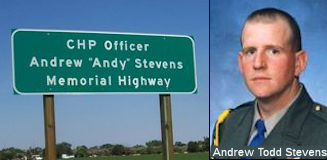 The section of Route 16 in Yolo
County between I-505 and County Road 98 (~ YOL 32.302 to YOL R40.572) is
named the "CHP Officer Andrew "Andy" Stevens Memorial Highway". It
was named in memory of California Highway Patrol (CHP) Officer Andrew
"Andy" Todd Stevens, born in February 1968 in Sacramento, California. Andy
Stevens attended Kohler Elementary School in North Highlands. He then
attended Carmichael Baptist Academy where he graduated from high school in
1986. Following high school, he attended American River College and
Sacramento City College where he studied criminal justice. Law enforcement
was his career of choice. In May 1994, Andy Stevens was selected for the
position of Cadet at the CHP Academy. Upon graduation, CHP Officer Stevens
was assigned to road patrol in Baldwin Park. Later, he worked in San Jose,
Golden Gate Communications Center, Golden Gate Division, and the Woodland
area. In May 2002, he found his true calling and was assigned as a
Commercial Officer in Valley Division, serving the Sacramento area. While
working in Woodland, CHP Officer Stevens met an Emergency Medical
Technician named Michelle, who was working for American Medical Response
Ambulance Company. They were married on October 20, 2002, at Lake Tahoe.
CHP Officer Stevens' life was packed with achievements. He was the
Director of the Auburn Chapter of the Harley Owners Group and was
instrumental in organizing and coordinating numerous charitable events. He
was in his second year of organizing the Annual Toy Run in Auburn, which
raises toys for over 1,000 disadvantaged children in the community. CHP
Officer Stevens was killed on November 17, 2005, in a felonious assault
while working road patrol near Route 16 in rural Yolo County. CHP Officer
Stevens had initiated a traffic stop for a Vehicle Code violation and
approached the violator's vehicle when he was suddenly and ruthlessly shot
by the driver. The driver fled the scene and was apprehended less than 12
hours later. CHP Officer Stevens was laid to rest in Sacramento County
after a ceremony attended by thousands of mourners, including his fellow
officers, friends, and family. Named by Assembly Concurrent Resolution
(ACR) 141, Resolution Chapter 137, on 9/5/2008.
The section of Route 16 in Yolo
County between I-505 and County Road 98 (~ YOL 32.302 to YOL R40.572) is
named the "CHP Officer Andrew "Andy" Stevens Memorial Highway". It
was named in memory of California Highway Patrol (CHP) Officer Andrew
"Andy" Todd Stevens, born in February 1968 in Sacramento, California. Andy
Stevens attended Kohler Elementary School in North Highlands. He then
attended Carmichael Baptist Academy where he graduated from high school in
1986. Following high school, he attended American River College and
Sacramento City College where he studied criminal justice. Law enforcement
was his career of choice. In May 1994, Andy Stevens was selected for the
position of Cadet at the CHP Academy. Upon graduation, CHP Officer Stevens
was assigned to road patrol in Baldwin Park. Later, he worked in San Jose,
Golden Gate Communications Center, Golden Gate Division, and the Woodland
area. In May 2002, he found his true calling and was assigned as a
Commercial Officer in Valley Division, serving the Sacramento area. While
working in Woodland, CHP Officer Stevens met an Emergency Medical
Technician named Michelle, who was working for American Medical Response
Ambulance Company. They were married on October 20, 2002, at Lake Tahoe.
CHP Officer Stevens' life was packed with achievements. He was the
Director of the Auburn Chapter of the Harley Owners Group and was
instrumental in organizing and coordinating numerous charitable events. He
was in his second year of organizing the Annual Toy Run in Auburn, which
raises toys for over 1,000 disadvantaged children in the community. CHP
Officer Stevens was killed on November 17, 2005, in a felonious assault
while working road patrol near Route 16 in rural Yolo County. CHP Officer
Stevens had initiated a traffic stop for a Vehicle Code violation and
approached the violator's vehicle when he was suddenly and ruthlessly shot
by the driver. The driver fled the scene and was apprehended less than 12
hours later. CHP Officer Stevens was laid to rest in Sacramento County
after a ceremony attended by thousands of mourners, including his fellow
officers, friends, and family. Named by Assembly Concurrent Resolution
(ACR) 141, Resolution Chapter 137, on 9/5/2008.
(Image source: Find a grave)
 Scenic Route
[SHC 263.3] From Route 20 to Capay.
 Freeway
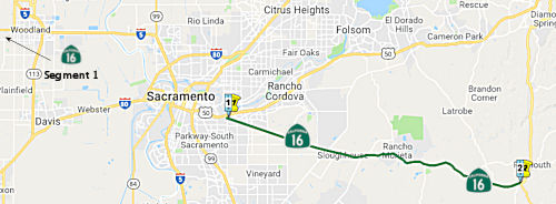 From Route 50 near Perkins to Route 49 near Drytown.
The vehicle code explicitly permits (21115.5) a golf cart or a low-speed vehicle to cross Route 16 at Murieta Drive and at Murieta South Parkway if the crossing is controlled by an official traffic control device and is at an angle of approximately 90 degrees to the direction of the highway. The Rancho Murieta Community Services District is permitted to take any reasonable measures within its jurisdiction that are necessary to ensure that golf carts and low-speed vehicles may cross safely and that highway traffic is not unreasonably impeded thereby. This is permitted only until January 1, 2007. (Permitted until 1/1/2006 by SB 612, Chapter 16, 6/24/2003; extended by AB 188, 6/30/2006, Chapter 26).
Post 1964 Signage HistoryIn 1963, segment (b) was defined as "(b) Route 5 near Woodland to Sacramento", and there was a segment (c): "(c) Route 50 near Perkins to Route 49 near Drytown."
In 1984, the original segment (b) was deleted by Chapter 409. The deleted segment was Level Road and Sacramento Avenue, and ran past the Yolo County offices. That segment was still LRN 50 (defined in 1933), and continued into downtown Sacramento. It was cosigned with Route 24. There was also a small portion between Route 160 and Route 99 near Sacramento via Broadway. This was defined in 1910 as part of LRN 4, and appears to have been removed from the system by 1975, although it was formally removed in 1984.
In 1971, Route 16 was routed in Sacramento from Howe Avenue from the future US 50 freeway centerline to Folsom Boulevard, and Folsom Boulevard from Howe Avenue to Jackson Road (which had been primarily signed as US 50), were adopted as part of Route 16 in order to sustain a signed route connection from US 50 to Jackson Highway. Reasons to believe the adoption was successful include that the postmile range T1.658 to 2.530 was successfully assigned.
In 2014, segment (2) was modified to authorize relinquishment in the City of Sacramento. Authorized by AB 1957, Chapter 335, 9/15/2014.
In 2015, AB 652, Chapter 630, 10/08/15, revised the relinquishment authorization to apply to a specified portion of Route 16 that is located within the unincorporated area of the county, between the general easterly city limits of the City of Sacramento and near Grant Line Road, and imposed additional conditions on the relinquishment:
(c) Upon a determination by the commission that it is
in the best interests of the state to do so, the commission may, upon
terms and conditions approved by it, relinquish to the County of
Sacramento the portion of Route 16 that is located within the
unincorporated area of that county, and between the general easterly
city limits of the City of Sacramento, approximately post mile 3.3, and
0.2 miles east of Grant Line Road, approximately post mile 12.7, east
of the City of Sacramento boundary and west of Watt Avenue, if the
county agrees to accept it.
Chapter 630 (2015) also added the following conditions to item (c):
(G) The County of Sacramento shall ensure the continuity of traffic flow on the relinquished portion of Route 16 within its jurisdiction, including, but not limited to, any traffic signal progression.
(H) Any relinquishment agreement shall require that the County of Sacramento administer the operation and maintenance of the roadway in a manner that is consistent with professional traffic engineering standards.
(I) Any relinquishment agreement shall require the County of Sacramento to ensure that appropriate traffic studies or analyses will be performed to substantiate decisions affecting traffic on the roadway.
Chapter 630 (2015) also authorized the commission to relinquish to the City of Rancho Cordova a specified portion of Route 16:
(d) Upon a determination by the commission that it is in the best interests of the state to do so, the commission may, upon terms and conditions approved by it, relinquish to the City of Rancho Cordova the portion of Route 16 that is within the city limits of the city between Sunrise Boulevard, approximately post mile 11.5, and Grant Line Road, approximately post mile 12.5, if the city agrees to accept it. The following conditions shall apply upon relinquishment:
(1) The relinquishment shall become effective on the date following the county recorder’s recordation of the relinquishment resolution containing the commission’s approval of the terms and conditions of the relinquishment.
(2) On and after the effective date of the relinquishment, the relinquished portion of Route 16 shall cease to be a state highway.
(3) The portion of Route 16 relinquished under this subdivision shall be ineligible for future adoption under Section 81.
(4) For the portion of Route 16 relinquished under this subdivision, the City of Rancho Cordova shall apply for approval of a business route designation for the relinquished portion of the highway in accordance with Chapter 20, Topic 21, of the Highway Design Manual.
In March 2016, the CTC authorized relinquishment of right of way in the city of Sacramento on Route 16 (Howe Avenue, Folsom Boulevard, and Jackson Road) from Route 50 to the general easterly city limits, under terms and conditions as stated in the relinquishment agreement dated February 10, 2016, determined to be in the best interest of the State. Authorized by Chapter 630, Statutes of 2015, which amended Section 316 of the Streets and Highways Code. Additionally, the CTC also authorized relinquishment of right of way in the county of Sacramento on Route 16 (Jackson Road) from the general easterly city limits of the city of Sacramento to South Watt Avenue, under terms and conditions as stated in the relinquishment agreement dated February 11, 2016, determined to be in the best interest of the State. Authorized by Chapter 630, Statutes of 2015, which amended Section 316 of the Streets and Highways Code.
Pre 1964 Signage History In 1934, Route 16 was signed from Jct. Route 20 near Wilbur
Springs to Jackson via Sacramento. Route 16 may have been signed along the
portion of present-day Route 49 between Drytown and Jackson.
In 1934, Route 16 was signed from Jct. Route 20 near Wilbur
Springs to Jackson via Sacramento. Route 16 may have been signed along the
portion of present-day Route 49 between Drytown and Jackson.
In downtown Sacramento, Route 16 (LRN 50) came in around I Street, and then down 3rd/5th Streets to N Street. As of 2007, there was still a Route 16 postmile on the I Street bridge at the Yolo-Sacramento county line, facing eastbound into Sacramento. Route 16 the ran across N Street to 15th Street signed as Route 16. Route 16 continued along Capitol Avenue as LRN 11, joining US 50 at 29th/30th Street. It continued as LRN 11, signed as US 50, along Folsom Blvd to Perkins, where it diverged from US 50.
Actually, the N Street/Capitol Avenue (originally M Street in the 1940s)
routing had been the following highways, in progression: US 40/US 99W and
Route 16 in 1942, and just Route 16 by 1963. Sometime in the mid-1960s,
Route 16 ran co-signed with US 99W and US 40 via P and Q Streets and
returned to Capitol Avenue via 15th and 16th Streets (former US 40,
current Route 160)—whether they were cosigned is unknown. After the
construction of the WX Freeway (the unsigned I-305 segment), signage for
Route 16 was removed from downtown Sacramento and may have
followed I-5 south of the I Street Bridge and east via the Topple Alley
ramp on current Business Route 80 to Perkins, which is now indistinguishable from the
rest of Sacramento (but still retains mention in the legislative
definition of Route 16). According to a late-1960s map of the Sacramento
Valley present in UC Davis's Storer Hall, Route 16 was co-signed with I-5
from future Exit 537 (Main Street, former Route 16) to future exit 531
(County Road 22), where Route 16 then split off to follow the Sacramento
River into West Sacramento and Bryte. Thus, County Road 22 was
de-designated as part of Route 16 after the construction of I-5 in the
area; but the route to I Street would not be removed immediately after
I-5's arrival. From 1981 (when I-80 was moved off the WX and 29/30
routings that make up the Capital City Freeway/Business Route 80), Route 16's implied
multiplex east of Topple Alley would be with US 50/Route 99/Business Route 80/I-305.
(Thanks to Chris Sampang for this information.)
At this point, the current routing resumed. It was signed as Route 16, but was LRN 54, between the junction with US 50 (LRN 11) and Route 49
(LRN 65) near Drytown. The portion of LRN 54 between US 50 and the county
line near Michigan Bar was defined in 1933; the remainder of the route
between the county line and Route 49 near Drytown was defined in 1919.
 In 1960, a 1.8 mi freeway corridor was adopted by the CHC. This proposal existed
through the 1970s, where Route 16 would be taken off of the surface roads
west of Watt Avenue (Jackson Road, Folsom Boulevard (former US 50) and
Power Inn Road) and given its own short freeway bypass connecting the
Manlove district (where Watt Avenue and the El Dorado Freeway meet up)
with the current junction of Watt and Jackson Road. This seems to
approximate the county-constructed expressway on the Watt Avenue corridor.
In 1975, Caltrans requested public comment on the abandonment of the
corridor from Route 50 near Watt Ave to the existing Route 16 at Hedge
Avenue.
In 1960, a 1.8 mi freeway corridor was adopted by the CHC. This proposal existed
through the 1970s, where Route 16 would be taken off of the surface roads
west of Watt Avenue (Jackson Road, Folsom Boulevard (former US 50) and
Power Inn Road) and given its own short freeway bypass connecting the
Manlove district (where Watt Avenue and the El Dorado Freeway meet up)
with the current junction of Watt and Jackson Road. This seems to
approximate the county-constructed expressway on the Watt Avenue corridor.
In 1975, Caltrans requested public comment on the abandonment of the
corridor from Route 50 near Watt Ave to the existing Route 16 at Hedge
Avenue.
(Image source: Sacramento Bee, 11/25/1975, via Joel Windmiller
2/23/2023)
StatusIn August 2008, the CTC authorized relinquishment of right of way along Route 16 in the county of Sacramento near Sloughhouse, from 100 feet west of Sunrise Boulevard to 300 feet east of Murieta Parkway (~ SAC R11.492 to SAC 19.471), consisting of reconstructed county road connections.
In July 2017, it was reported that Sacramento County has asked Caltrans
to give it control of 8 miles of Jackson Highways (Route 16) —
currently a two-lane road — so the county can turn it into an urban
arterial street that would function as the spine for up to 30,000 new
homes in the coming decades, allowing the metropolitan area to march east
as far as Grant Line Road (~ SAC 12.498). Amador County officials are
crying foul, saying the highway will be just another major suburban road,
jammed with stop-and-go traffic. That, they say, will make it harder for
tourists to get to Amador’s wine region and historic towns like
Sutter Creek, and harder for foothill country residents to get to valley
jobs and medical appointments. Amador wants Caltrans and Sacramento to
offer some neighborly consideration, such as minimizing traffic signals
along the way. Caltrans, which has said it is willing to
“relinquish” the highway west of Grant Line to the locals, is
declining to place restrictions on Sacramento’s future management of
the road. Gedney said the situation could lead to a lawsuit. The drive
from historic Jackson to Sacramento, now an hour, could stretch to an hour
and a half, and there really is no other route that isn’t a detour
for Amador residents, officials there say. Sacramento County officials say
they plan to increase the road to six lanes, reduce speeds from 55 mph to
45 mph, and increase the number of intersections with traffic signals from
six to about 17. Those traffic signals would be sequenced to make traffic
movement smoother. Express buses could share outside lanes with cars. Bike
lanes or nearby bike paths will be added. The city of Rancho Cordova will
control a slice of the road along its boundary. There are no plans to
alter the highway east of Grant Line Road, which is outside of
Sacramento’s designated urban growth boundary and will remain under
Caltrans control. The state previously relinquished a 2-mile section of
the highway west of South Watt Avenue to the city of Sacramento for
development. By relinquishing the road, Caltrans will free itself of
operations and maintenance costs, and future costs involved in making
changes to the road. It is not unusual for Caltrans to give up ownership
of older highways as they are absorbed into growing metropolitan areas.
Caltrans relinquished the Freeport Boulevard section of Route 160 to the
city of Sacramento and also turned over Route 275 to West Sacramento.
Officials with Caltrans said they had planned to turn the highway over to
local control this year, but last week announced a delay until late 2019.
State officials said studies pertaining to cultural resources will take
longer than was anticipated.
(Source: Sacramento Bee, 7/7/2017)
In May 2008, the CTC considered relinquishment of right of way in the city of Rancho Cordova, at Grant Line Road (~ SAC 12.498), consisting of a reconstructed city street.
In December 2009, the CTC relinquished right of way in the county of Sacramento along Route 16 at Michigan Bar Road and Ione Road (~ SAC R22.568), consisting of reconstructed county road connections. The CTC also vacated right of way in the county of Sacramento along Route 16 from 0.1 mile west of Michigan Bar Road to the Amador County line, consisting of highway right of way no longer needed for State highway purposes.
In August 2008, the CTC vacated right of way along Route 16 in the county of Sacramento near Sloughhouse, between 0.1 miles west and 0.2 miles east of the intersection with Latrobe Road (~ AMA R6.398), consisting of highway right of way no longer needed for State highway purposes.
Naming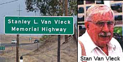 The portion of this route from Dillard Road in Sacramento County and the Amador County line (~ SAC
R16.014 to SAC 23.81) is named the "Stanley L. Van Vleck Memorial
Highway". Stanley L. Van Vleck was born in 1920 near Placerville,
California. A third-generation Californian, he grew up on his family's
homestead that was established about 1850. He later moved to a rance in
Sloughhouse, California. He had a long and distinguished career as a
rancher in the Sacramento region, and served in many leadership positions
in agricultural organizations at the local, state, and national level,
including the California Cattlemen's Association, the California Farm
Bureau, the National Flying Farmers, and the National Cattlemen's
Association. He also allowed the Federal Bureau of Investigation, the
California Air National Guard, the California Department of Forestry, the
Sacramento County Sheriff's Department, the Sacramento City Police
Department, and the Sacramento Life Flight Unit to train on his ranch. He
spearheaded the creation of the Cosumnes River School District and served
as the President of that district's governing board for many years. He
also shared his ranch with the entire community by allowing tens of
thousands of Boy Scouts, 4-H'ers, Future Farmers of America, local
students, California Operating Engineers, recreationists, and families a
chance to experience agriculture and open space on his ranch. He lost his
life in an accident while working at his beloved Sloughhouse ranch on
September 7, 2000. One article noted: For at least 40 years, the
soft-spoken Van Vleck - a 1937 graduate of Elk Grove High School at age 16
- allowed Boy Scouts free access to 200 acres of his property to conduct
activities. Since 1991, Van Vleck let the Andersons' Boy Scout troops use
the property for its spring Camporee. He put a water well in solely for
the Boy Scouts' use, according to Steve Anderson. Van Vleck also shared
his land with 4-H clubs, Future Farmers of America, California Operating
Engineers, Girl Scout troops, local students and families who wanted a
chance to experience open space. He hosted training for the FBI, the
Sacramento sheriff's and police departments, the California Air National
Guard and the Department of Forestry. He also allowed the property to be
used for a 2,000-person Civil War re-enactment and other activities. In
the 1940s, Van Vleck spearheaded the creation of the Cosumnes River School
District - even though he was not yet married and had no children at the
time. He was the district's school board president for many years. Knowing
that many young children were not attending school, he convinced parents
to volunteer to help build an elementary school - Cosumnes River
Elementary. It became part of the Elk Grove Unified School District in
1959. Named by Assembly Concurrent Resolution 4, Resolution Chapter 61,
filed June 7, 2001.
The portion of this route from Dillard Road in Sacramento County and the Amador County line (~ SAC
R16.014 to SAC 23.81) is named the "Stanley L. Van Vleck Memorial
Highway". Stanley L. Van Vleck was born in 1920 near Placerville,
California. A third-generation Californian, he grew up on his family's
homestead that was established about 1850. He later moved to a rance in
Sloughhouse, California. He had a long and distinguished career as a
rancher in the Sacramento region, and served in many leadership positions
in agricultural organizations at the local, state, and national level,
including the California Cattlemen's Association, the California Farm
Bureau, the National Flying Farmers, and the National Cattlemen's
Association. He also allowed the Federal Bureau of Investigation, the
California Air National Guard, the California Department of Forestry, the
Sacramento County Sheriff's Department, the Sacramento City Police
Department, and the Sacramento Life Flight Unit to train on his ranch. He
spearheaded the creation of the Cosumnes River School District and served
as the President of that district's governing board for many years. He
also shared his ranch with the entire community by allowing tens of
thousands of Boy Scouts, 4-H'ers, Future Farmers of America, local
students, California Operating Engineers, recreationists, and families a
chance to experience agriculture and open space on his ranch. He lost his
life in an accident while working at his beloved Sloughhouse ranch on
September 7, 2000. One article noted: For at least 40 years, the
soft-spoken Van Vleck - a 1937 graduate of Elk Grove High School at age 16
- allowed Boy Scouts free access to 200 acres of his property to conduct
activities. Since 1991, Van Vleck let the Andersons' Boy Scout troops use
the property for its spring Camporee. He put a water well in solely for
the Boy Scouts' use, according to Steve Anderson. Van Vleck also shared
his land with 4-H clubs, Future Farmers of America, California Operating
Engineers, Girl Scout troops, local students and families who wanted a
chance to experience open space. He hosted training for the FBI, the
Sacramento sheriff's and police departments, the California Air National
Guard and the Department of Forestry. He also allowed the property to be
used for a 2,000-person Civil War re-enactment and other activities. In
the 1940s, Van Vleck spearheaded the creation of the Cosumnes River School
District - even though he was not yet married and had no children at the
time. He was the district's school board president for many years. Knowing
that many young children were not attending school, he convinced parents
to volunteer to help build an elementary school - Cosumnes River
Elementary. It became part of the Elk Grove Unified School District in
1959. Named by Assembly Concurrent Resolution 4, Resolution Chapter 61,
filed June 7, 2001.
(Addtional bio information: Van Vleck Ranch; Image sources: RanchoMurieta, RanchoMurieta)
 Other WWW Links Freeway
[SHC 253.2] From Route 50 near Perkins to Route 49 near Drytown. Added to the Freeway and Expressway system in 1959.
 Interregional Route
[SHC 164.11] Between the east urban limits of Sacramento and Route 49.
 Statistics
Overall statistics for Route 16:
Pre 1964 Signage HistoryRoute 16 was numbered as part of the initial state signage of routes in 1934.
 Pre-1964 Legislative Route
The routing that would become LRN 16 was defined in the 1909 First Bond Act as running from Hopland to Lakeport. It remained unchanged, and was codified into the 1935 codes as:
[LRN 16] is from Hopland to Lakeport
It was considered a primary route in its entirety.
In 1939, Chapter 473 changed the reference from "Hopland" to "[LRN 1]". In 1961, Chapter 1146 relaxed the description by changing the terminus to "[LRN 89] near Lakeport", making the final wording "From [LRN 1] (US 101) to [LRN 89] (Route 29) near Lakeport."
This segment was believed to be unsigned in 1963; it is presently signed as Route 175.
© 1996-2020 Daniel P. Faigin.
Maintained by: Daniel P. Faigin
<webmaster@cahighways.org>.
 Route 15
 Route 17
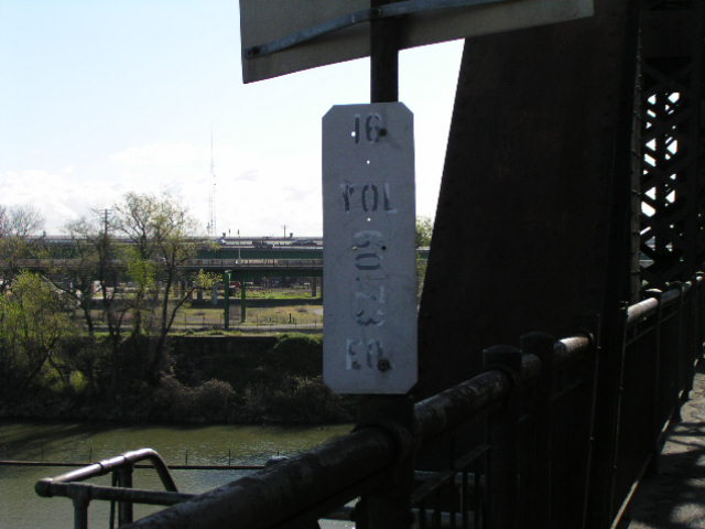