
 California Highways:
Click here for a key to the symbols used. An explanation of acronyms may be found at the bottom of the page.
 Routing
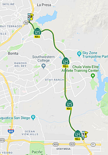 From Route 905 near Brown Field to Route 54.
 Post 1964 Signage History
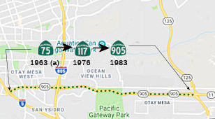 In 1963, Route 125 was defined as the route
from "Route 75 near Brown Field to Route 56 passing near La Mesa." The
Route 75 referenced in this definition was a segment of Route 75 defined
at that time as "Route 125 east of Brown Field to Route 5 near the south
end of San Diego Bay." In 1972, a new definition of Route 117 was created
(the previous one having been deleted in 1965) was was defined as " "the
international boundary near Borderfield northeasterly to Route 5." These
come together because, in 1975, the 1963 segment of Route 75 was
transferred to Route 117 (and, in 1983, to Route 905).
In 1963, Route 125 was defined as the route
from "Route 75 near Brown Field to Route 56 passing near La Mesa." The
Route 75 referenced in this definition was a segment of Route 75 defined
at that time as "Route 125 east of Brown Field to Route 5 near the south
end of San Diego Bay." In 1972, a new definition of Route 117 was created
(the previous one having been deleted in 1965) was was defined as " "the
international boundary near Borderfield northeasterly to Route 5." These
come together because, in 1975, the 1963 segment of Route 75 was
transferred to Route 117 (and, in 1983, to Route 905).
In 1964, the Highway commission located two freeway stretches on Route 125. One is for approximately our miles between I-8 in La Mesa and two-tenths mile south of Mission Gorge Road west of El Cajon. The second extends for 8.5 miles between four-tenths mile north of the Otay River and future Route 54 in the unincorporated community of Sunnyside.
In 1965, it was announced that two freeway segments of Route 125 had been
adopted by the California Highway Commission. The first segment
began at I-8 in La Mesa and extended north to Mission Gorge Road to a
planned junction with Route 52. The second segment extended north
from the Otay River. Also in 1965, it was announced that a freeway
alignment north of Blossom Lane connecting to I-8 in La Mesa had been
adopted by the California Highway Commission.
(Source: Gribblenation Blog (Tom Fearer), "California State Route 125", 1/7/2022)
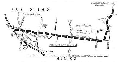 In 1965, the CHC adopted a freeway routing for Route 125
and Route 75. Route 75 later became Route 117 and then Route 905.
Specifically, the CTC adopted freeway routings for 9.7 miles of
interconnected Route 75 and Route 125 near the Mexican border. The new
alignment will take Route 75 easterly for 7.1 miles from I-5 near 27th
Street, just south of Iris Avenue in San Diego, to about a halfmile east
of Brown Field. From this point, the newly adopted alignment for Route 125
runs 2.6 miles northward, with a slight jog to the west between Johnson
Canyon and the Otay River. It connects on the north with a previously
adopted location for Route 125 northward to Route 54 near Sweetwater
Reservoir. The Route 75 and Route 125 freeways will form the southern and
eastern legs of a belt-line system of freeways around the San Diego
Metropolitan area.
In 1965, the CHC adopted a freeway routing for Route 125
and Route 75. Route 75 later became Route 117 and then Route 905.
Specifically, the CTC adopted freeway routings for 9.7 miles of
interconnected Route 75 and Route 125 near the Mexican border. The new
alignment will take Route 75 easterly for 7.1 miles from I-5 near 27th
Street, just south of Iris Avenue in San Diego, to about a halfmile east
of Brown Field. From this point, the newly adopted alignment for Route 125
runs 2.6 miles northward, with a slight jog to the west between Johnson
Canyon and the Otay River. It connects on the north with a previously
adopted location for Route 125 northward to Route 54 near Sweetwater
Reservoir. The Route 75 and Route 125 freeways will form the southern and
eastern legs of a belt-line system of freeways around the San Diego
Metropolitan area.
In 1965, Chapter 1371 split the route into three segments: "(a) Route 75 near Brown Field to Route 54. (b) Route 54 to Route 94 near La Mesa. (c) Route 94 near La Mesa to Route 56."
In 1972, Chapter 1216 changed the origin of this segment to "The international boundary southerly of Brown Field".
In 1986, Chapter 928 transferred the portion added to in 1972 to Route 905, making (a) "(a) Route 905 near Brown Field to ..."
Environmental Impact Studies began on the corridor of Route 125 south of
Route 54 during 1987. During 1990 the Caltrans proposed building
Route 125 south of Route 54 as a tolled facility. Much of the new
routing of Route 125 south of Route 54 was determined by March 1997, but
progress towards construction stalled due to numerous environmental
concerns. Route 125 south from Route 94 to Route 54 was opened to
traffic during May 2003 via an interim non-freeway alignment following
Sweetwater Road. Construction of the South Bay Expressway commenced
during September 2003. Route 125 from I-8 north to Route 52 was
fully completed by mid-year 2004. Route 125 south of Route 94 to
Route 54 was brought to full freeway standards during 2005. Route 125 on the South Bay Express was opened to traffic during November 2007
operated by the South Bay Expressway Company. The South Bay
Expressway Company declared Chapter 11 bankruptcy during March 2010.
Ultimately the South Bay Expressway was purchased by the San Diego
Association of Governments ("SANDAG") for $345,000,000.
(Source: Gribblenation Blog (Tom Fearer), "California State Route 125", 1/7/2022)
 Pre 1964 Signage History
This segment was part of "routing determined" proposed LRN 282, defined in 1959. Specifically, this was part of segment (a): [LRN 281] near United States Auxiliary Air Station, Brown FIeld to [LRN 198] near La Mesa.. LRN 281 was Route 117, now Route 905. LRN 198 was Route 67.
Route 125 was not defined as part of the initial state signage of routes in 1934. It is unclear what (if any) route was signed as Route 125 between 1934 and 1964.
 Status
Route 125 / Route 905 / Route 11 Connectors (~ SD 0.000)
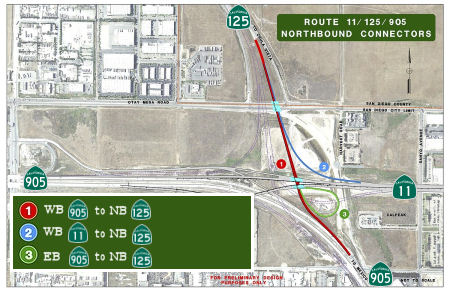 In October 2015, it was reported that work had begun on
construction of the connectors between Route 125, Route 905, and Route 11.
Officials said over the past two decades, trade between the U.S. and
Mexico has grown by an average of 10 percent a year — an increase
that exceeds that of U.S. trade with the rest of the world. Last year,
more than 800,000 northbound trucks and $39 billion in goods passed
through the Otay Mesa Port of Entry. The $21.5 million project is expected
to be completed in late 2016. Funding sources include a $15.9 million
chunk from Proposition 1B Trade Corridors Improvement Fund and $2.7
million from the TransNet half-cent sales tax for transportation uses
approved by San Diego County voters, among other funding sources. Caltrans
officials said the project is designed to remedy one of the last missing
links in the overall border road network. Currently, truckers congest city
streets and local roads to access Route 125. The new connectors will
create a seamless highway system, greatly reducing wait times at the
border, according to Caltrans.
In October 2015, it was reported that work had begun on
construction of the connectors between Route 125, Route 905, and Route 11.
Officials said over the past two decades, trade between the U.S. and
Mexico has grown by an average of 10 percent a year — an increase
that exceeds that of U.S. trade with the rest of the world. Last year,
more than 800,000 northbound trucks and $39 billion in goods passed
through the Otay Mesa Port of Entry. The $21.5 million project is expected
to be completed in late 2016. Funding sources include a $15.9 million
chunk from Proposition 1B Trade Corridors Improvement Fund and $2.7
million from the TransNet half-cent sales tax for transportation uses
approved by San Diego County voters, among other funding sources. Caltrans
officials said the project is designed to remedy one of the last missing
links in the overall border road network. Currently, truckers congest city
streets and local roads to access Route 125. The new connectors will
create a seamless highway system, greatly reducing wait times at the
border, according to Caltrans.
(Source: KPBS, 10/26/2015)
In November 2016, it was reported that construction
crews just wrapped up a year-long project that will help reduce congestion
at the Otay Mesa Port of Entry. Three freeway connectors that link Route 905 and Route 11 to the northbound South Bay Expressway (Route 125) opened
to traffic. More than 7,000 trucks travel across the Otay Mesa Border
Crossing every day. The heavy traffic here during rush hour has caused
major headaches for anyone trying to get to toll road Route 125 from Route 905 and Route 11. Before the connectors, vehicles exiting the Otay Mesa
Port of Entry had no direct access to northbound 125 and drivers were
forced to use local streets just to get there. Now, the new access will
provide another option of travel for people living in southern San Diego
and eastern Chula Vista. Drivers can avoid congestion on I-805 and I-5 by
going east on Route 905 and north on Route 125. Now that the northbound
connectors are complete, officials with SANDAG say they are hard at work
finishing up designs on the southbound connectors. That project expected
to begin construction in 2018.
(Source: CW 6, 11/30/2016)
With respect to the Southbound Connectors: In June
2019, it was reported that Skanska has won the construction contract for
Route 905 in San Diego, California. The $101 Million contract with
California Department of Transportation (Caltrans) is for a four-lane
highway with freeway connectors on Route 905, located at Otay Mesa, one of
three ports of entry in the San Diego-Tijuana Mexico metropolitan region.
Construction work includes two freeway-to-freeway flyover bridges that
will connect three highways (Route 125, Route 11 and Route 905), as well
as a 1.25-mile greenfield extension of Route 11 to the east toward a
future port-of-entry. The project will involve more than 15,000m3
of structural concrete, 30,000m3 of concrete paving, 35,000
tons of asphalt, and about 840,000 m3 of earthworks.
Construction is scheduled for completion in September 2021.
(Source: Construction Index, 6/10/2019)
In June 2019, the CTC amended the TCEP Project Baseline
Agreement and established it as the basis for project delivery and
monitoring. The amendment programmed $1,708,000 in savings from the TCIF
program for construction on the Route 125/Route 905 Connector project
(PPNO 1036) in San Diego County. This project is one of six projects
included in the Baseline Agreement for the California-Mexico Border System
Network Improvements. The Route 125/Route 905 Connector project will
construct a freeway to freeway South-West connector, thereby completing
the remaining connector needed to integrate three major state roads
serving the border region just north of the Otay Mesa Port of Entry at the
United States/Mexico border. In May 2018, the project received $21,980,000
in TCEP funding. In August 2018, the California-Mexico Border System
Network Improvements Baseline Agreement was approved, including this Route 125/905 Connector project. In February 2019, bid results from an adjacent
project along the same corridor reflected a 10 percent increase in project
costs. Upon review of those bid results, the project development team
prepared a revised cost estimate for the Route 125/905 Connector project
using the updated unit prices from the adjacent project. The revised
estimate indicated a cost increase of approximately $1,708,000. Therefore,
the Department and SANDAG propose to program $1,708,000 in TCIF savings
from other projects to this connector project. A construction allocation
of the programmed TCEP and TCIF funds is expected to be requested in Fall
2019.
(Source: June 2019 CTC Minutes, Agenda Item
2.1s.(1))
In June 2019, the CTC amended the Trade Corridors
Improvement Fund Program to add the Route 125/Route 905 Connector Project
in San Diego County as Project 133, at a cost of $1,708,000. The Route 125/Route 905 Connector Project will construct a southbound Route 125
freeway connector to the westbound Route 905 freeway to integrate three
major state roads serving the border region just north of the Otay Mesa
Port of Entry. This project will contribute to a safer and more efficient
border highway network that will alleviate congestion while providing more
reliability for cross border international freight movements. The Trade
Corridors Enhancement Program Baseline Agreement, approved in August 2018
will be amended to include the Trade Corridors Improvement Fund, thereby
eliminating the need to adopt a stand-alone Trade Corridors Improvement
Fund Baseline Agreement. The recently refined engineer’s estimate
identified a cost increase of $1,708,000 in construction to bring the
total estimated construction cost to $33,108,000. The need for the
additional funds is due to updated unit pricing based on recently opened
bids on nearby projects. The funding for this amendment is made available
through savings generated from other projects programmed in the Trade
Corridor Improvement Fund and is consistent with the Trade Corridors
Improvement Fund Program Close-Out Policy approved at the May 2019
Commission.
(Source: June 2019 CTC Minutes, Agenda Item 4.27)
In March 2020, the CTC approved an allocation of
$23,636,000 for the State-Administered Multi-Funded TCEP/TCIF Route 125/Route 905 Connector (PPNO 1036) project, on the State Highway
System, in San Diego County. Specifically, the resolution was that
$18,636,000 be allocated from the Budget Act of 2017 and 2019, Budget Act
Items 2660-301-3291 and 2660-304-6056 for construction and $5,000,000 for
construction engineering for the State-Administered Multi-Funded TCEP/TCIF
project: 11-SD-905 PM 9.8/9.8: Route 125/Route 905 Connector. In and near
San Diego at Route 125/Route 905 separation. Construct freeway to freeway
South-West connector.
(Source: March 2020 CTC Minutes, Agenda Item
2.5s.(6))
In April 2020, it was reported that crews from Skanska
US Civil were constructing the final segment of the future Toll Route 11
and the southbound connector ramps, linking southbound Route 125 to
eastbound Route 11 and eastbound state Route 905. Construction began on
Skanska's contract ($103M) began in July 2019 and will be completed August
2021. Roadway and connector ramp construction currently underway will
ultimately provide a direct connection to the new Otay Mesa East Port of
Entry and a California Highway Patrol Commercial Vehicle Enforcement
Facility, helping to enable fast, predictable, and secure border
crossings. Since construction began last summer, crews have focused their
efforts on building 1.2 new mi. of Route 11 and setting up falsework for
the construction of the two connector bridges at the Route 11/Route 905/Route 125 interchange. This work includes roadway and connector ramp
construction, earth work, site preparation, and drainage infrastructure
installation. Six bridges (cast-in-place box tube girder types) are being
constructed for the interchange — two connector and four smaller
underpass ones and the paving of Route 11 (east-west) that will connect
with the new POE, three lanes in direction, will start in October and be
finished in March 2021. One unique aspect of this project is the inclusion
of a divergent diamond interchange, one of the first to be built in
California. There are two connector bridges at the interchange, one that
will connect southbound Route 125 to eastbound Route 11 and the other will
connect southbound Route 125 to eastbound Route 905.
(Source: Construction Equipment Guide, 4/7/2020)
 In December 2020, it was reported that San Diego leaders
hosted a remote groundbreaking celebration to mark the start of
construction on the final connector between Route 125 and Route 905, which
will bridge southbound Route 125 to westbound Route 905. This will
complete Route 125 when finished. It will also provide a better connection
between East San Diego County and East Chula Vista to Otay Mesa and the
U.S.-Mexico border.
In December 2020, it was reported that San Diego leaders
hosted a remote groundbreaking celebration to mark the start of
construction on the final connector between Route 125 and Route 905, which
will bridge southbound Route 125 to westbound Route 905. This will
complete Route 125 when finished. It will also provide a better connection
between East San Diego County and East Chula Vista to Otay Mesa and the
U.S.-Mexico border.
(Source: NBC 7 San Diego, 12/17/2020)
In December 2021, it was reported that the new
southbound Route 125 to eastbound Route 905 and eastbound Route 11 freeway
connectors in Otay Mesa were completed. The connectors will provide a
direct highway connection from East County and Chula Vista to the Otay
Mesa area and the existing Otay Mesa Port of Entry. These connectors also
will enhance existing transit connections and create a connection for the
future planned Otay Mesa East Port of Entry.
(Source: District 11 on FB, 12/16/2021)
In July 2022, it was reported that Local and state
officials from the U.S. and Mexico celebrated the completion of Route 11,
which will connect to the future Otay Mesa East Port of Entry.
Representatives from the California Department of Transportation
(Caltrans) and the San Diego Association of Governments (SANDAG) were
joined by area politicians in applauding the project‘s completion.
The new highway will connect East San Diego County to the Otay Mesa area.
Route 11 connects southbound Route 125 to westbound Route 905. The new
connector completes the Route 125/Route 905/Route 11 interchanges that
will improve the border region mobility. The $28.9 million infrastructure
project was made possible by more than $16 million in funding from Senate
Bill (SB) 1, the Road Repair and Accountability Act of 2017.
(Source: NBC San Diego, 7/28/2022)
South Bay Expressway (Toll Road) (~ SD L1.014 to SD 8.804)
![[SB Expressway]](maps/125-sbexpressway.gif) *TOLL* This is a 11.2-mile, north-south toll road between Route 905 and Route 54.
It was originally to be constructed by California Private Ventures, Inc.
However, as of September 2002, according to a report by Eric Armourer from
the Union Tribune, California Private Ventures sold those rights to an
Austrailian firm that had many successful similar projects. He reported
that the article seemed to imply that though there have been three
lawsuits against the project since the rights were granted in July 2001.
It seems that the major hold up was the ability to get construction
financing, a problem that was not an issue with the new firm. The article
states that the tollway is expected to break ground in January 2003. Tolls
may be collected until 2047.
*TOLL* This is a 11.2-mile, north-south toll road between Route 905 and Route 54.
It was originally to be constructed by California Private Ventures, Inc.
However, as of September 2002, according to a report by Eric Armourer from
the Union Tribune, California Private Ventures sold those rights to an
Austrailian firm that had many successful similar projects. He reported
that the article seemed to imply that though there have been three
lawsuits against the project since the rights were granted in July 2001.
It seems that the major hold up was the ability to get construction
financing, a problem that was not an issue with the new firm. The article
states that the tollway is expected to break ground in January 2003. Tolls
may be collected until 2047.
According to Don Hagstrom in October 2002, the Route 125 Toll Freeway between Route 54 (South Bay Freeway) and Route 905 was to be completed by 2005. This toll freeway will initially be 4 lanes, with an ultimate plan for 8 lanes in the northern section and 6 lanes from southern Chula Vista to the Route 905 Freeway.
According to Sign On San Diego in April 2003, construction was to begin shortly on the Southern Extension of this route. According to the article, "Planners first envisioned state Route 125 more than 40 years ago. It took another 20 years, as Chula Vista began to annex land to the east and residential developers created new neighborhoods, for local officials to declare the route a necessary part of the regional transportation plan.". The article notes that toll road portion was held up by legislation for a while, but is now cleared for construction. This is due to the fragile ecosystem, which contains several threatened species, including fairy shrimp, the Quino checkerspot butterfly and the Otay tarplant. Developers have spent $2.5 million to acquire more than 1,000 acres of land, including parcels northeast of Sweetwater Reservoir and east of Otay Reservoir, where those species will be protected.
In November 2007, the 10 mile South Bay Expressway
opened between Route 905 and Route 54. As of May 2008, the toll road draws
an average of 30,000 drivers each weekday, about what state transportation
officials expected. Many cash-paying customers have complained about the
automated toll machines, while some Chula Vista merchants say it has not
fueled the business boom they were hoping for. Tolls range from 75 cents
to $3.75, depending on the length of the trip and how it is paid –
with cash or through an electronic toll system called FasTrak. According
to the Macquarie Infrastructure Group, the parent company of South Bay
Expressway, the tollway generated an average of $54,600 in daily revenue
from mid-January through March, or about $2 per vehicle. The road attracts
an average of 26,500 vehicles daily, including weekends. Nearly four out
of five motorists pay through FasTrak. As a result of construction of the
route, according to Caltrans, the volume of morning traffic on northbound
I-805 in Chula Vista has dropped 11% since opening. Congestion has
increased, however, at two interchanges north of the tollway: at Route 125
and Route 94, and at Route 125 and I-8 in La Mesa.
[Source: SD Union Tribune]
In Mid-January, the cost of driving the South Bay Expressway, increased by as much as 75¢. Tolls for cash-paying customers will increase 50 to 75 cents, to a range of $2.50 to $4.50 per trip, depending on length. Just under 30,000 vehicles travel at least part of the 10-mile roadway each weekday.
In March 2010, the South Bay Expressway (SBE) company
filed for a reorganization in Chapter 11 US bankruptcy, writing off around
$200m in shareholder equity. The project suffered from being in an area
affected by the subprime mortgage meltdown, as well as major ongoing
litigation over huge claims made by Fluor/URS, the contractors who built
the road but spent over a year longer than contracted at the job. SBE are
proposing to the US Banktuptcy Court that it address both the
reorganization and write-off of debt and the Fluor/URS litigation claims,
which are cited as a major reason for the Chapter 11 filing.
(Source: "South Bay Expressway company files for bankruptcy in San Diego", Tollroad News, 3/24/2010)
In July 2011, it was reported that the San Diego Assn. of Governments agreed to purchase the bankrupt Route 125 toll road near the U.S.-Mexico border for approximately $345 million. Under the new ownership, the road won't be free but tolls will be reduced.
In December 2014, the CTC authorized relinquishment of right of way in the city of San Diego along Route 125 at Lonestar Road (a/k/a La Media Rd, ~SD L1.799), consisting of collateral facilities. The City, by freeway agreement dated November 27, 2000, agreed to accept title upon relinquishment by the State. The 90-day notice period expired October 28, 2014.
In January 2022, it was reported that the Mayor of
Chula Vista is pushing to have the tolled section of the route (between
Route 54 and Route 905) be toll free by 2027. The South Bay Expressway
opened in 2007 and was purchased in 2011 by the San Diego Association of
Governments. The current debt obligation is due to end in 2042. The Mayor
wants SANDAG to find a way to pay off the $172 million it owes for the
South Bay Expressway by 2027. Mayor Salas will ask the Chula Vista City
Council to support a resolution requesting the toll road become a
state-owned freeway by 2027.
(Source: 7 San Diego, 1/21/2022)
In July 2022, it was reported that board members of the
San Diego Association of Governments (SANDAG) approved a resolution
declaring support for eliminating the toll and prioritizing a plan to pay
off debt the agency owes by 2027. The South Bay Expressway, which opened
in 2007, is the 10-mile stretch of Route 125 that runs from Route 905 in
Otay Mesa to Route 54 in Spring Valley and sees about 54,000 drivers
daily. Tolls range from 50 cents to $3.50. SANDAG has operated the road
since it acquired it in 2011 for $341.5 million, about one-third of what a
private consortium spent to build it, according to the agency. They still
owe about $180 million in bond payments and the debt must be paid off by
2042. Chula Vista wants that paid off by 2027 for multiple reasons. First,
Route 125 is underutilized because drivers are avoiding the tools,
creating traffic problems on local roads and I-805 and I-5. Second, it
will support economic development efforts in the South Bay and will help
advance travel and commerce with the opening of the new U.S.-Mexico border
crossing in Otay Mesa. After several meetings between Chula Vista and
SANDAG, as well as state lawmakers and the California Department of
Transportation, SANDAG has agreed to a financial plan that could help the
agency pay off its debt by 2027. At the request of state Sen. Ben Hueso,
whose District 40 includes Chula Vista, the new state budget allocated $20
million to SANDAG to further reduce its outstanding bond balance. That
leaves about $15 million to $16 million in debt left. Caltrans should
support the toll removal effort, but under certain conditions. For
example, the move would have to align with the state’s climate and
equity goals, such as reducing greenhouse gas emissions and encouraging
the use of public transit. SANDAG would also have to turn over the road
and equipment, such as rails, signage and electrical items, in good
condition. Caltrans may need to defer other maintenance projects to
takeover Route 125 maintenance costs.
(Source: San Diego Union Tribune, 7/8/2022)
In December 2020, the CTC authorized relinquishment of 11-SD-125-PM
6.9/9.0 (12 segments), right of way consisting of collateral facilities,
in the county of San Diego along Route 125 on San Miguel Road, Summit
Meadow Road, Quarry Road, Sweetwater Road, and Worthington Street. The
County agreed to waive the 90-day notice requirement and accept title upon
relinquishment by the State by letter dated July 29, 2020.
(Source: December 2020 CTC Agenda, Agenda Item
2.3c)
 Naming
 "South Bay Expressway"
(Image source: San Diego Forward)
 Named Structures
 The horse bridge that crosses Route 125 and is
located in Bonita, west of the Summit Park Campground in San Diego County
(Bridge 57-1176, SD 008.00, Sweetwater Regional Trail POC), is named the "Mary
Augustine Bridge". This segment was named in honor of Mary
Augustine, a long-time resident of Bonita, California, and an equestrian
and trail advocate. In 1969, Mary was a founding member of a new horse
club in Bonita called Equestrian Trails, Inc. (E.T.I.), a national club
with a southwestern base in Los Angeles whose purpose was to build a
network of trails throughout the country. The Bonita Club, E.T.I. Corral
89, concentrated its efforts in Bonita and worked in concert with other
corrals throughout San Diego County. From its early days through the
subsequent reorganization and creation of Bonita Valley Horsemen (BVH) in
February 1975, through approximately 1989, Mary worked tirelessly on
various trails projects in Bonita and San Diego County. Mary was
instrumental in getting the first large trail project in Bonita started
and completed. It is the current trail around the Chula Vista Golf Course
used by, among others, riders, bikers, and hikers, During the critical
years of the 1970s and 80s, Mary worked with state and local agencies and
persuaded developers to give land easements for dedicated trails, or to
preserve existing trails, through Bonita Downs, Bonita Woods Park, Bonita
Ridge, and Ranchito Robinwood. These trails were to eventually feed into
other trails planned for Sweetwater Regional Park. At that point there
were an estimated 1,300 horses in Bonita, and San Diego County had the
largest per capita population of horses in the U.S.A. As time went on
developers began to see the wisdom of calling Mary for advice regarding
trails through their developments or rerouting existing trails. As
interest and success in local and county trails grew, horse camps at
Cuyamaca Rancho State Park had come into being and the Anza-Borrego horse
camp was on the horizon. Mary was one of the first volunteers on the
Mounted Assistance Unit, designed to aid park rangers on search and rescue
missions, patrol the areas of the park that the rangers could not get to
easily, uphold park rules, interpret the park regulations, and many other
duties. In the late 1970s, Mary headed up the new Sweetwater Summit Park
east towards Jamul and the trail was built with the aid of a Comprehensive
Employment and Training Act grant in the amount of $40,000. This trail was
dedicated July 17, 1980, and on that day Mary led the first trail ride on
the new trail, which is still used today regularly by riders, bikers, and
hikers. Mary's ultimate goal, which she fulfilled, was to ride from the
Pacific Ocean to Cuyamaca State Park and beyond to the desert regions of
Cleveland National Park. Named by Assembly Concurrent Resolution (ACR) 17,
Resolution Chapter 59, on 6/22/2007.
The horse bridge that crosses Route 125 and is
located in Bonita, west of the Summit Park Campground in San Diego County
(Bridge 57-1176, SD 008.00, Sweetwater Regional Trail POC), is named the "Mary
Augustine Bridge". This segment was named in honor of Mary
Augustine, a long-time resident of Bonita, California, and an equestrian
and trail advocate. In 1969, Mary was a founding member of a new horse
club in Bonita called Equestrian Trails, Inc. (E.T.I.), a national club
with a southwestern base in Los Angeles whose purpose was to build a
network of trails throughout the country. The Bonita Club, E.T.I. Corral
89, concentrated its efforts in Bonita and worked in concert with other
corrals throughout San Diego County. From its early days through the
subsequent reorganization and creation of Bonita Valley Horsemen (BVH) in
February 1975, through approximately 1989, Mary worked tirelessly on
various trails projects in Bonita and San Diego County. Mary was
instrumental in getting the first large trail project in Bonita started
and completed. It is the current trail around the Chula Vista Golf Course
used by, among others, riders, bikers, and hikers, During the critical
years of the 1970s and 80s, Mary worked with state and local agencies and
persuaded developers to give land easements for dedicated trails, or to
preserve existing trails, through Bonita Downs, Bonita Woods Park, Bonita
Ridge, and Ranchito Robinwood. These trails were to eventually feed into
other trails planned for Sweetwater Regional Park. At that point there
were an estimated 1,300 horses in Bonita, and San Diego County had the
largest per capita population of horses in the U.S.A. As time went on
developers began to see the wisdom of calling Mary for advice regarding
trails through their developments or rerouting existing trails. As
interest and success in local and county trails grew, horse camps at
Cuyamaca Rancho State Park had come into being and the Anza-Borrego horse
camp was on the horizon. Mary was one of the first volunteers on the
Mounted Assistance Unit, designed to aid park rangers on search and rescue
missions, patrol the areas of the park that the rangers could not get to
easily, uphold park rules, interpret the park regulations, and many other
duties. In the late 1970s, Mary headed up the new Sweetwater Summit Park
east towards Jamul and the trail was built with the aid of a Comprehensive
Employment and Training Act grant in the amount of $40,000. This trail was
dedicated July 17, 1980, and on that day Mary led the first trail ride on
the new trail, which is still used today regularly by riders, bikers, and
hikers. Mary's ultimate goal, which she fulfilled, was to ride from the
Pacific Ocean to Cuyamaca State Park and beyond to the desert regions of
Cleveland National Park. Named by Assembly Concurrent Resolution (ACR) 17,
Resolution Chapter 59, on 6/22/2007.
(Image source: GrokSurf's San Diego, SD Union Tribune, Equestrian Trails Inc)
 Other WWW Links
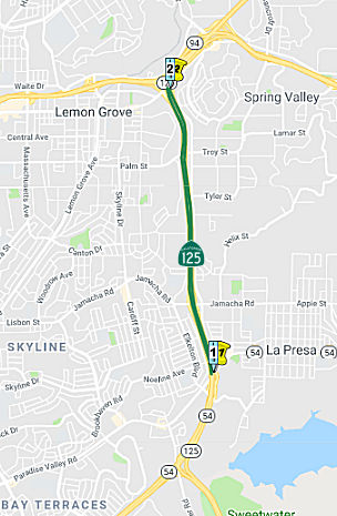 From
Route 54 to Route 94 near La Mesa.
From
Route 54 to Route 94 near La Mesa.
Post 1964 Signage HistoryIn 1963, Route 125 was defined as the route from "Route 75 near Brown Field to Route 56 passing near La Mesa."
In 1965, Chapter 1371 split the route into three segments: "(a) Route 75 near Brown Field to Route 54. (b) Route 54 to Route 94 near La Mesa. (c) Route 94 near La Mesa to Route 56." This is the 1965 segment (b).
Pre 1964 Signage HistoryThis segment was part of "routing determined" proposed LRN 282, defined in 1959. Specifically, this was part of segment (a): [LRN 281] near United States Auxiliary Air Station, Brown FIeld to [LRN 198] near La Mesa.. LRN 281 was Route 117, now Route 905. LRN 198 was Route 67.
In 1963, 2.3 freeway miles of LRN 282 from planned LRN 280 (Route 54) north to Blossom Lane in Lemon Grove was adopted by the California Highway Commission. This is roughly this Route 125 segment.
Route 125 was not defined as part of the initial state signage of routes in 1934. It is unclear what (if any) route was signed as Route 125 between 1934 and 1964.
StatusIn November 2005, the CTC considered relinquishment of right of way in the County of San Diego, from Swap Meet Road to Palm Street (~ SD 9.802 to SD 12.075), consisting of reconstructed and relocated county roads, frontage roads, and cul-de-sacs.
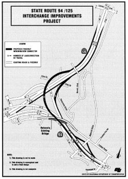
Route 125 / Route 54 Interchange (~ SD 9.925)
This is part of the "Inner Loop" route. The Route 125 southern extension along Sweetwater Road opened in early May 2003. There is a gap between the end of the Route 54 freeway and the start of Route 125 fwy, but there is construction along this portion. However, Route 54 eastbound does directly turn into Route 125 northbound—there's just one signalized intersection at Sweetwater Rd southbound. Farther north on Route 125, the freeway is open continuously from Route 94 all the way to Route 52 in both directions. And the Route 52/Route 125 freeway to freeway interchange was completed some time ago. There is still construction on Route 125 at Grossmont College Dr with traffic in both directions squeezed onto the northbound lanes. But all intersections and stoplights have been eliminated. Note: when heading southbound on Route 125 thru the Route 94/Route125 interchange, you have to exit far right to "stay" on Route 125, as the freeway maintains its legacy of the "thru" direction being onto westbound Route 94.
The construction noted above was completed with the opening of the toll road section to the south; the final phase of the construction was the interchange with Route 54. Since Route 125 was designed as part of a loop route, the main lanes connect though as follows - Route 125 South to Route 54 West, Route 54 East to Route 125 North. The section from Route 94 north to Route 52 is also complete, and has been since 2005. Signs have recently been posted near the Route 52/Route 125 interchange for the extension of Ropute 52 further east, which will require some work on the interchange at the northern end of Route 125. These signs indicate a projected completion date of 2011. There appears to be no any movement toward the extension of Route 56 or for the extension of Route 25 further north. It currently (2008) ends at an at-grade T intersection beneath the Route 125 North-Route 52 West flyover ramp.
NamingThe portion of this route constructed to freeway standards is named the "Ramona Freeway". It is part of the "Inner Loop" with Route 52 and Route 54. Ramona was the central character in the Helen Hunt Jackson novel Ramona, which was a seminal novel in the early 20th century in creating the romance of California.
 Commuter Lanes
HOV lanes are planned between 0.2 mi N of Tyler Street to Route 94.
 From Route 94 near La Mesa to Route 56.
Post 1964 Signage HistoryIn 1963, Route 125 was defined as the route from "Route 75 near Brown Field to Route 56 passing near La Mesa."
In 1965, Chapter 1371 split the route into three segments: "(a) Route 75 near Brown Field to Route 54. (b) Route 54 to Route 94 near La Mesa. (c) Route 94 near La Mesa to Route 56." This is the 1965 segment (c).
In 1965, it was announced that two freeway segments of Route 125 had been
adopted by the California Highway Commission. The first segment
began at I-8 in La Mesa and extended north to Mission Gorge Road to a
planned junction with Route 52. The second segment (part of Route 125 section (b)) extended north from the Otay River. Also in 1965, it was
announced that a freeway alignment north of Blossom Lane connecting to I-8
in La Mesa had been adopted by the California Highway Commission. At the
end of 1965, it was announced that the California Highway Commission had
adopted a freeway routing of Route 125 from Mission Gorge Road northward
10.8 miles to planned Route 56 in Poway.
(Source: Gribblenation Blog (Tom Fearer), "California State Route 125", 1/7/2022)
Pre 1964 Signage HistoryLRN 198 originally ran along Palm Avenue between Route 94/LRN 200 north
to US 80/LRN 12, reading LRN 12 at La Mesa Boulevard. In 1939, a new
alignment of US 80/LRN 12 from El Cajon east to La Mesa had been completed
during 1939; this bypassed much of La Mesa on El Cajon Boulevard; this
resulted in LRN 198 being rerouted over former US 80/LRN 12 on La Mesa
Boulevard. By 1955, a new freeway corridor alignment of LRN 198 had been
assigned as an extension of Route 67, with construction started during the
1955-1957 period. The Route 67/LRN 198 freeway in La Mesa was dedicated on
March 12th, 1957. This freeway became part of Route 125 with the 1964
renumbering.
(Source: Gribblenation Blog (Tom Fearer), "California State Route 125", 1/7/2022)
The segment from US 80/I-8 to Route 56 was "routing determined" proposed
LRN 282, defined in 1959. Specifically, this was segment (b): [LRN 198]
near La Mesa to [LRN 277] [LRN 278]. LRN 198 was
Route 67; LRN 278 was Route 56. LRN 277 was what became Route 371, and was
clearly a typo in the original definition.
Route 125 was not defined as part of the initial state signage of routes in 1934. It is unclear what (if any) route was signed as Route 125 between 1934 and 1964.
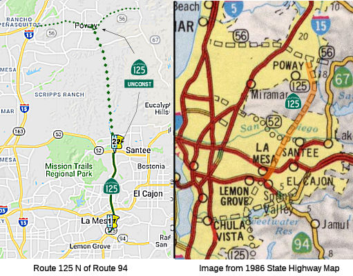
StatusUnconstructed Portion

 Completed between Route 94 and
Route 52 . The remainder, from Route 52 to Route 56, is proposed but no
completion date has been set. The section between Amaya Drive and Fletcher
Parkway opened on 1/3/2001.
Completed between Route 94 and
Route 52 . The remainder, from Route 52 to Route 56, is proposed but no
completion date has been set. The section between Amaya Drive and Fletcher
Parkway opened on 1/3/2001.
The 2013 Traversable Highways report notes, for the portion between Route 52 and Route 56: Route adopted: 7/21/65. No current plans to develop a state highway in this segment.
In December 2009, the CTC relinquished right of way in the city of La Mesa along Routes 94 and 125 between Grove Street and Spring Street (~ SD M10.274), consisting of relocated and reconstructed county roads and frontage roads. The County of San Diego, by freeway agreement dated September 30, 1968, agreed to accept title upon relinquishment by the State to roads which on that date were within an unincorporated area of the county and have since been annexed by the City.
Route 125 / Route 94 Interchange (11-SD-125, PM R10.5/T11.5)
 In September 2000, the California Transportation Commission considered a $1.7
million phase 1 proposal (TCRP Project #87) for two new freeway connector
ramps at the Route 94/Route 125 interchange. Total estimated cost is $90
million. This funding was extended in September 2005 as the project is
ready to proceed. In April 2007, the CTC amended project 87.2 to orogram
an additional $3,610,000 in TCRP funds for Project Approval &
Environmental Document (PA&ED). This project will construct the
ultimate two-lane freeway-to-freeway connectors from westbound Route 94 to
northbound Route 125 and from southbound Route 125 to eastbound Route 94.
The project will also widen Route 125 providing additional lanes from
Spring Street to Lemon Avenue, and provide auxiliary lanes from the
connectors to the next interchange at Lemon Avenue. The additional
$3,610,000 for PA&ED was needed to study impacts to the large number
of residential, commercial, and resource rich areas that will be impacted
by this project. It is estimated that four years will be required to
complete the needed environmental studies, complete the draft
environmental document, circulate it for public comment, and gain final
approval. The project was scheduled for construction between FY 2012 and
FY 2017.
In September 2000, the California Transportation Commission considered a $1.7
million phase 1 proposal (TCRP Project #87) for two new freeway connector
ramps at the Route 94/Route 125 interchange. Total estimated cost is $90
million. This funding was extended in September 2005 as the project is
ready to proceed. In April 2007, the CTC amended project 87.2 to orogram
an additional $3,610,000 in TCRP funds for Project Approval &
Environmental Document (PA&ED). This project will construct the
ultimate two-lane freeway-to-freeway connectors from westbound Route 94 to
northbound Route 125 and from southbound Route 125 to eastbound Route 94.
The project will also widen Route 125 providing additional lanes from
Spring Street to Lemon Avenue, and provide auxiliary lanes from the
connectors to the next interchange at Lemon Avenue. The additional
$3,610,000 for PA&ED was needed to study impacts to the large number
of residential, commercial, and resource rich areas that will be impacted
by this project. It is estimated that four years will be required to
complete the needed environmental studies, complete the draft
environmental document, circulate it for public comment, and gain final
approval. The project was scheduled for construction between FY 2012 and
FY 2017.
In August 2016, the CTC approved for future consideration of funding a project on Route 94 (11-SD-94, PM 13.6/14.6) and Route 125 (11-SD-125, PM R10.5/T11.5) in San Diego County that will construct a freeway-to-freeway connection from southbound Route 125 to eastbound Route 94 in the city of La Mesa. The project is not fully funded. The project is programmed in the Traffic Congestion Relief Program. The total estimated cost is $188,496,000 for capital and support. Depending on the availability of funding, construction is estimated to begin in Fiscal Year 2018-19. The Department has identified the need for a scope change to reduce the number of connectors from two to one. An amendment will be placed on the October 2016 California Transportation Commission meeting agenda to reflect the scope change.
In January 2017, it was reported that construction had
not yet commenced on this project, although some homes in the area had
been sold by Caltrans. A fact sheet from January 2016 noted that the
project encompasses two miles, with the freeway-to-freeway connector
passing under the existing Route 125 and joining eastbound Route 94
between Bancroft and Kenwood drives, according to the fact sheet.
Construction of two auxiliary lanes is planned: one lane along southbound
Route 125 from Lemon Avenue to the connector and the other lane from the
connector to Kenwood Drive. Other proposed improvements include replacing
the Mariposa Street overcrossing, widening the Route 94 bridges over
Bancroft Drive, constructing “bridge structures” on Panorama
Drive and Echo Drive over the connector, and constructing noise barriers
along Route 94 and Route 125. The estimated project cost totaled $71.33
million, with $5 million coming from the State Transportation Congestion
Relief Program and $1.7 million in TransNet funds from the San Diego
Association of Governments (SANDAG) for environmental studies.
(“TransNet,” says SANDAG’s website, “is the
half-cent sales tax for local transportation projects that was first
approved by voters in 1988, and extended in 2004 for another 40
years.”) However, “construction of these improvements will be
scheduled as funding becomes available.” In December 2016, Caltrans
project manager Lou Melendez responded, when asked about the status of the
project. “We stopped the project when we ran out of money.” He
said Caltrans funds ran out in 2015, and the project was “put on a
shelf.” Melendez said there was no funding because the
SANDAG-sponsored Measure A failed in November. In the year “2021,
things might improve”. The City of La Mesa is aware of the project
status, and that it is awaiting funding, said Greg Humora, the La Mesa
public works director/city engineer whose promotion to assistant city
manager was announced at the December 13, 2016 city-council meeting. On
December 15, Humora said the Route 125/Route 94 is the “number one
interchange project in the county” and identified by “TransNet
as a high-priority project.”
(Source: San Diego Reader, 1/18/2017)
In June 2017, the CTC authorized the following TCRP allocation: Allocation Amendment - TCRP Project. Request the reallocation of $536,000 for Environmental on TCRP Project 87.2 – Build two new freeway connector ramp projects in San Diego County. (PPNO 0356) [Approved.]: This is a financial re-allocation of $536,000 for TCRP Project 87.2 – Route 94/Route 125; build two new freeway connector ramps project (PPNO 0356) in San Diego County. Re-allocate $536,000 in previously allocated funds for PA&ED.
The 2018 STIP, approved at the CTC March 2018 meeting, appears to allocate Advance Project Development Element (APDE) funding of $7.948M in FY18-19 for PS&E on PPNO 0356 Route 94/Route 125 Connectors.
The 2020 STIP, approved at the CTC March 2020 meeting,
continued the programmed funding for PPNO 0356 "Rt 94/125 Connectors
(APDE)".
(Source: March 2020 CTC Agenda, Item 4.7, 2020 STIP
Adopted 3/25/2020)
In August 2020, the CTC approved an allocation of
$4,000,000 for the State-Administered Senate Bill 1 (SB 1) Local
Partnership Program (LPP) (Formulaic) Route 94/Route 125 Connector
(PPNO 0356) project.
(Source: August 2020 CTC Agenda, Agenda Item
2.5s.(1))
In April 2010, the CTC relinquished right of way in the city of Lemon Grove along Route 125 between Ildica Street and Sweetwater Way (~ SD 11.512), consisting of collateral facilities. The County of San Diego, by freeway agreements dated September 30, 1968 and January 2, 1969, agreed to accept title upon relinquishment by the State to roads which on that date were within an unincorporated area of the county and have since been annexed by the City of Lemon Grove. The 90-day notice period expired January 12, 2010, without exception.
In December 2016, the CTC authorized relinquishment of right of way in the city of La Mesa along Route 125 on Bowling Green Drive and Echo Drive (11-SD-125-PM 13.5/14.0) and along Route 94 on Panorama Drive (11-SD-94-PM 10.5/10.8), consisting of collateral facilities. The City, by letter dated August 1, 2016, agreed to waive the 90-day notice requirement and accept title upon relinquishment by the State.
In October 2006, the CTC considered relinquishment of right of way in the city of La Mesa, from Alvarado Avenue to Blue Lake Drive (~ SD 18.493), consisting of reconstructed and relocated city streets and frontage roads.
In October 2008, the CTC considered relinquishment of right of way in the city of San Diego along Route 125 near Fletcher Parkway (~ SD 18.556) on East Lake Drive between Flume Road and Lake Angela Drive, consisting of relocated and reconstructed city streets.
There have been some plans to connect Route 125 with Route 79, making an east-side freeway corridor to I-10.
NamingThe portion of this route constructed to freeway standards is named the "Ramona Freeway". It is part of the "Inner Loop" with Route 52 and Route 54. Ramona was the central character in the Helen Hunt Jackson novel Ramona, which was a seminal novel in the early 20th century in creating the romance of California.
Named StructuresBridge 57-0972R over Fletcher Parkway in San Diego County (SD 018.42) is named the "Benjamin E. Polak Memorial Bridge". It was built in 1991, and was named (before construction) by Assembly Concurrent Resolution 120, Chapter 64, in 1990. Benjamin E. Polack, President of Harbor Management, was active in the United Way and instrumental in its establishment in Costa Rica in the 1970's.
Commuter Lanes Exit Information Other WWW Links
 Scenic Route
 Classified Landcaped Freeway
The following segments are designated as Classified Landscaped Freeway:
| County | Route | Starting PM | Ending PM |
| San Diego | 125 | 9.59 | 12.68 |
| San Diego | 125 | 12.77 | 13.71 |
| San Diego | 125 | 14.12 | 18.45 |
| San Diego | 125 | R18.54 | 22.14 |
 Freeway
[SHC 253.1] Entire route. Added to the Freeway and Expressway system in 1959.
 Statistics
Overall statistics for Route 125:
 Pre-1964 Legislative Route
In 1933, Chapter 767 defined the segments from "[LRN 56] near Moro to [LRN 4] near Fresno via Stratford" and "[LRN 4] near Fresno to Yosemite National Park" as part of the highway system. In 1935, this was defined in the highway code as LRN 125, with the definition:
In 1937, Chapter 841 removed the explict routing via Stratford and fixed some spellings in segment (a), giving "[LRN 56] near Morro to [LRN 4] near Fresno"
This route was signed as follows:
From LRN 56 (Route 1) near Morrow to LRN 4 (US 99) near Fresno.
This was US 466 (present-day Route 41) between Morro Bay and Cholame, and Route 41 between Cholame and US 99 in Fresno. It appears that the LRN 125 routing between Atascadero and Shandon was unsigned, although the portion between Creston and Shandon became Route 229 after 1964. The portion between Shandon and Cholame was cosigned Route 41 and US 466. N of Cholame, LRN 125 was solely Route 41.It appears that from 1933 through 1958, US 466 was aligned from
downtown Atascadero eastward through Rocky Canyon towards Creston and
Shandon. This initial alignment of US 466 was apparently never
signed, as it included a dirt segment through Rocky Canyon that had
been added into the State Highway System in 1933 as part of LRN 125.
US 466 in 1958 was shifted west of Shandon to Atascadero via a
multiplex of Route 41 west to Paso Robles and southbound US 101. This
alignment swap of US 466 was requested by the California Division of
Highways to the AASHO upon the completion of an upgrade to Route 41
(LRN 33) between Shandon and Paso Robles. In 1962, maintenance of LRN 125 through Rocky Canyon was transferred to San Luis Obispo County. In
time, former US 466 through Rocky Canyon was abandoned and eroded
away. Much of the former right of way of US 466 in Rocky Canyon
is now occupied by the CalPortland Rocky Canyon Quarry and Rocky
Canyon Trail.
(Source: FB Post from Tom Fearer, 5/21/2021)
This was Route 41.
© 1996-2020 Daniel P. Faigin.
Maintained by: Daniel P. Faigin
<webmaster@cahighways.org>.
 Route 124
 Route 126