
 California Highways:
Click here for a key to the symbols used. An explanation of acronyms may be found at the bottom of the page.
 Routing
No current routing.
 Post 1964 Signage History
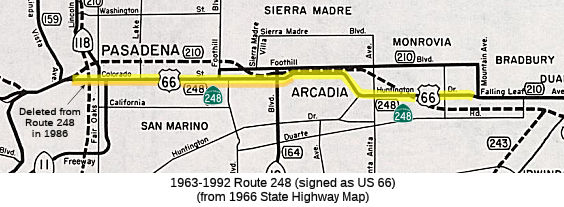 In 1963, Route 248 was defined as “Route 134 near Pasadena to Route 210 near Monrovia.”
In 1965, Chapter 1372 added a condition: “This route will cease to be a state highway when Interstate Route 210 freeway is completed and the commission relinquishes that portion of present Route 210 in the County of Los Angeles and the Cities of Pasadena, Arcadia, and Monrovia.”
Signage of US 66 would be truncated from Pasadena to US 95 when I-40 was
completed through the Bristol Mountains in 1972. At that point,
portions of Route 248 became signed as (California) Route 66.
(Source: Gribblenation Blog (Tom Fearer), "Former California State Route 248 (Old US Routes 66-99 from Pasadena to Monrovia)", 10/2022)
In 1986, Chapter 928 truncated the route: “Route 134 near
the east limit of the City of Pasadena to Route 210 near
Monrovia.” This left Route 248 as starting just W of Rosemead Blvd,
Route 164. Field signage at this time is unknown.
In 1992, the remainder of Route 248 was deleted by AB 3090, Chapter 1243.
 Pre 1964 Signage History
Post-1964 Route 248 corresponded to LRN 161, defined in 1933. It corresponded to a portion of the third segment of LRN 161, [LRN 4] near Glendale to [LRN 9] near Monrovia. LRN 4 was US 99 at San Fernando Road; LRN 9 was sign Route 118 in Pasadena at Lincoln, which turned into US 66. Portions of LRN 161 became Route 134.
The Route 248 portion of LRN 161 originated at sign Route 134 and
terminated at I-210 following the Colorado Street Bridge, Colorado
Boulevard, Colorado Place, and Huntington Boulevard. Much of Route 248 was signed as US 66 until 1972 and was gradually relinquished between
1986-1992.
(Source: Gribblenation Blog (Tom Fearer), "Former California State Route 248 (Old US Routes 66-99 from Pasadena to Monrovia)", 10/2022)
Portions of future Route 248 were also part of LRN 9 (specifically some
former US 66 routings along Colorado Blvd, until the freeway portions were
constructed). This was distinct from the routing of the the former
National Old Trails Road (NOTR) through Pasadena. From San Bernardino
beginning at Mount Vernon Avenue/4th Street, the NOTR followed existing
LRN 9 westbound to Pasadena. Upon reaching Pasadena the NOTR
branched away from LRN 9. The NOTR westbound jogged south on Santa
Anita Avenue to Colorado Boulevard in Pasadena and departed towards Los
Angeles via Fair Oaks Avenue. The NOTR followed Fair Oaks Avenue,
Huntington Drive, and Broadway into downtown Los Angeles where it
terminated at the intersection of Broadway and 7th Street.
(Source: Gribblenation Blog (Tom Fearer), "Former California State Route 248 (Old US Routes 66-99 from Pasadena to Monrovia)", 10/2022)
In 1926, US 99 and US 66 were created (the latter originally as US 60). US 99 was originally routed along US 66 multiplexed to San Bernardino, but both were rerouted as they officially went through Los Angeles. There are lots of discussions about the routing of US 66 -- see the Route 66 page for the summary of those discussions, as most do not impact Route 248.
In an exchange of letters by the Pasadena Chamber of Commerce and the
AASHO Executive Secretary between January-March 1932, the former expressed
a desire to move US 99/US 66 off of LRN 9/Foothill Boulevard via the East
Colorado Street Extension to Arcadia. The Pasadena Chamber of
Commerce noted the jog in US 99/US 66 was indirect and did not serve
through traffic well. The Pasadena Chamber of Commerce stated they
were instructed to petition the AASHO to move US 99/US 66 onto the East
Colorado Street Extension by the California State Highway Engineer.
The AASHO Executive Secretary deferred making a decision to reroute US 99/US 66 onto the East Colorado Street Extension to the California State
Highway Engineer given it was an intrastate matter. In 1933, the
State Legislature removed restrictions that prevented state funds from
being used to maintain urban roadways, leading to the creation of a number
of urban routes... including LRN 161 which added the East Colorado Street
Extension and Colorado Street Bridges to the State Highway System.
Also added was LRN 165 that was routed from San Pedro to La Canada via
Figueroa Street. The addition of LRN 165 made the three completed
Figueroa Street Tunnels part of the State Highway system and led to the
construction of the fourth southernmost tunnel. During 1934 US 99
was realigned off a multiplex of US 66 from Pasadena-San Bernardino (LRN 9
and LRN 161) to a new alignment that took it to Redlands via downtown Los
Angeles, Pomona, and Colton on LRN 26.
(Source: Gribblenation Blog (Tom Fearer), "Former California State Route 248 (Old US Routes 66-99 from Pasadena to Monrovia)", 10/2022)
In 1940, US 66 was rerouted onto the new Arroyo Seco Parkway, and the
older route on Figueroa Street was co-signed with Route 11 as US 66
Alternate. This made US 66A the designation across the Colorado
Street Bridge west of downtown Pasadena. US 66 was truncated to Needles in
1963, removing the official US 66 designation from Route 11 (although
signs likely remained), and getting rid of US 66A. The 1964 renumbering
created Route 248 to sign the underlying state highway across Colorado,
and US 66 remained signed to Monrovia although the route was Route 248.
(Source: Gribblenation Blog (Tom Fearer), "Former California State Route 248 (Old US Routes 66-99 from Pasadena to Monrovia)", 10/2022)
 Status
The Caltrans bridge log indicated that this route was signed in its entirety as Route 66.
 Historical Route
Former Rout 248 is signed as part of "Historic Highway Route 66", designated by Assembly Concurrent Resolution 6, Chapter 52, in 1991.
 National Trails
 Former route 248 (Colorado Blvd) was part of the "ArrowheadTrail
(Ocean to Ocean Trail)". It was named by Resolution Chapter 369 in
1925.
Former route 248 (Colorado Blvd) was part of the "ArrowheadTrail
(Ocean to Ocean Trail)". It was named by Resolution Chapter 369 in
1925.
 Former route 248 (Colorado Blvd) was part of the "National Old Trails Road".

 Former route 248 (Colorado Blvd) appears to have been part of the "National Park to Park Highway", and the "Pikes
Peak Ocean to Ocean Highway".
Former route 248 (Colorado Blvd) appears to have been part of the "National Park to Park Highway", and the "Pikes
Peak Ocean to Ocean Highway".
 Other WWW Links
 Pre-1964 Legislative Route
In 1959, Chapter 1062 defined LRN 248 as “[LRN 238] near Sacramento to [LRN 247] south of [LRN 54]”. This route ran from present-day I-5 near Sacramento to Elk Grove Florin Road south of Route 16. This is present-day Route 148 between I-5 and Route 143.
© 1996-2020 Daniel P. Faigin.
Maintained by: Daniel P. Faigin
<webmaster@cahighways.org>.
 Route 247
 Route 249