
 California Highways:
Click here for a key to the symbols used. An explanation of acronyms may be found at the bottom of the page.
 Routing
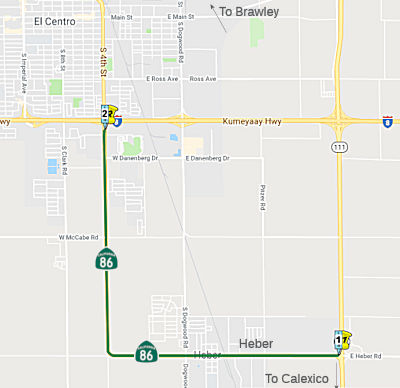 (a) (1) From Route 111 to Route 8 near El Centro.
(b) Upon a determination by the commission that it is in the best interests of the state to do so, the commission may, upon terms and conditions approved by it, relinquish the following portions of Route 86, if the department and the applicable local agency enter into an agreement providing for that relinquishment, as follows:
(1) To the County of Imperial, the portions of Route 86 within unincorporated areas of the county from the beginning of the route at the junction of Route 111 to 0.5 mile south of Fredricks Road.
(2) To the City of El Centro, the portion of Route 86 within its city limits.
 Post 1964 Signage History
This segment remains unchanged from its 1963 definition.
In 2013, Chapter 525 (SB 788, 10/9/13) added segment (b) and (b)(1) permitting relinquishment within unincorporated areas of the county and within El Centro.
A discussion of the Highways to Boulevards program during the March 2022
CTC meeting identified the following segment(s) as potential Highways to
Boulevards conversion projects: Imperial County: Route 86 from Route 111
(~ IMP R0.029) to Countryside Drive (~ IMP R0.029), and from Countryside
Drive (~ IMP R0.029) to Treshill Road (~ IMP 8.79)
(Source: March 2022 CTC Agenda, Agenda Item 4.3)
 Interstate Submissions
Submitted for inclusion in the interstate system in 1956; not accepted.
 (a) (2) From Route 8 near El Centro to Route 10 in Indio via the vicinity of
Brawley.
(a) (2) From Route 8 near El Centro to Route 10 in Indio via the vicinity of
Brawley.
(b) Upon a determination by the commission that it is in the best interests of the state to do so, the commission may, upon terms and conditions approved by it, relinquish the following portions of Route 86, if the department and the applicable local agency enter into an agreement providing for that relinquishment, as follows: [...]
(2) To the City of El Centro, the portion of Route 86 within its city limits.
(3) To the City of Imperial, the portion of Route 86 within its city limits.
(4) To the City of Brawley, the portion of Route 86 within its city limits.
(c) The following conditions shall apply upon relinquishment:
(1) The relinquishment shall become effective on the date following the county recorder’s recordation of the relinquishment resolution containing the commission’s approval of the terms and conditions of the relinquishment.
(2) On and after the effective date of the relinquishment, the relinquished portions of Route 86 shall cease to be a state highway.
(3) The portions of Route 86 relinquished under this subdivision shall be ineligible for future adoption under Section 81.
(4) The Cities of Brawley, El Centro, and Imperial and the County of Imperial shall ensure the continuity of traffic flow on the relinquished portions of Route 86, including any traffic signal progression.
(5) For the portions of Route 86 that are relinquished under this subdivision, the Cities of Brawley, El Centro, and Imperial, and the County of Imperial shall install and maintain, within their respective jurisdictions, the city or county signs directing motorists to the continuation of Route 86 to the extent deemed necessary by the department.
(d) Following the relinquishments authorized in subdivision (b), the portion of Route 86 from 0.5 mile south of Fredricks Road to the north junction of Route 78 shall be redesignated as a part of Route 78.
Post 1964 Signage HistoryIn 1963, this segment was defined as "Route 8 near El Centro to Route 10 via the vicinity of Brawley."
In 1984, Chapter 409 clarified the terminus to be "Route 10 in Indio via the vicinity of Brawley."
The section of Route 86 in Brawley was adopted as a Freeway in 1945. A Freeway Agreement had never been executed in the City of Brawley. This section of Route 86 was recently denominated to Controlled Access Highway (CAH) in 2005. It is a four-lane highway with paved shoulders and a median.
In 2013, Chapter 525 (SB 788, 10/9/13) added segment (b) and (b)(1) permitting relinquishment within unincorporated areas of the county and within El Centro, Imperial, and Brawley, and added the language regarding Route 78 (e.g., (d)).
In December 2016, the CTC authorized relinquishment of right of way in the city of Imperial on Route 86 from the south city limits to the north city limits, under terms and conditions as stated in the relinquishment agreement dated March 22, 2016, determined to be in the best interest of the State. Authorized by Chapter 523, Statutes of 2013, which amended Section 386 of the Streets and Highways Code.
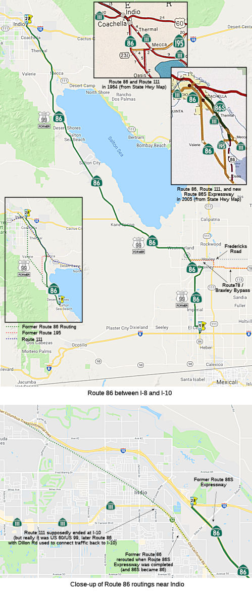
Note: With the completion of the Route 86 expressway, the old routing along Harrison to Oasis was removed, as no longer shows as part of the route in the Postmile Tool.
A discussion of the Highways to Boulevards program during the March 2022
CTC meeting identified the following segment(s) as potential Highways to
Boulevards conversion projects: Imperial County: West Ralph Road (~ IMP
12.325) to Calle Estrella (~ IMP 18.655), and east of Brandt Road (~ IMP
21.774) to Route 78(~ IMP R24.005).
(Source: March 2022 CTC Agenda, Agenda Item 4.3)
 Pre 1964 Signage History
 This was originally signed as US 99, and was part of LRN 26, defined
in 1915/1916. The northbound lanes of the original expressway are original
US 99. The original route through Coachella and Thermal is along Harrison
Avenue, and then diagonally to Pierce (starting at 66th). It was resigned
as Route 86 in 1964.
This was originally signed as US 99, and was part of LRN 26, defined
in 1915/1916. The northbound lanes of the original expressway are original
US 99. The original route through Coachella and Thermal is along Harrison
Avenue, and then diagonally to Pierce (starting at 66th). It was resigned
as Route 86 in 1964.
Brawley
LRN 26 (future US 99) was first routed through Brawley
with the 1916 extension of LRN 26, and started to show on maps in 1918. By
1924, the alignment of LRN 26 through Brawley appears to be on Main Street
and Western Avenue. LRN 26 was signed US 99 in 1926, and by that time,
grading and road improvement was in progress. In 1932, the city of Brawley
requested assistance with improving US 99/LRN 26 on Western Avenue; and in
1933, a 0.4-mile-long contract to realign US 99/LRN 26 in Brawley was
awarded. The new alignment of US 99 on 1st Street was east of Western
Avenue. Repaving occurred in 1946. In 1953, the new New River Bridge was
dedicated, replacing a timber span that had been damaged during the May
1940 earthquake. This alignment remained signed as US 99 until the
truncation of US 99 to Los Angeles in 1963. In the 1964 renumbering, this
became part of Route 86.
(Source: Gribblenation Blog (Tom Fearer), "Former US Route 99 in Brawley", 10/2022)
Westmorland (currently 86 IMP 27.496)
US 99 was aligned on Main Street within Westmorland
from 1926 until it was truncated to downtown Los Angeles in 1963.
The routing is currently Route 86. The route was first planned around
1918. LRN 26 through Westmorland was not part of any major Auto
Trails. In fact, LRN 26 took a series of ninety-degree jogs between
Brawley and Westmorland. The alignment of LRN 26 through Westmorland
appears to be aligned on Main Street and Center Street. By 1925, LRN 26
was realigned and surfaced through Westmorland, with the realignment of
LRN 26 extending one mile west of Westmorland. In 1970. signage for
Route 78 was extended through Westmorland via multiplex of Route 86
following the addition of Ben Hulse Highway as part of the State Highway
System. The road connecting Brawley to Glamis opened on August 13th,
1958, according to a San Diego Tribune article.
(Source: Gribblenation Blog (Tom Fearer), "Former US Route 99 in Westmorland", September 2022)
The portion of the route between former Route 78 and Brawley was part of the planned Imperial
Highway. The name "Imperial" refers to the Imperial Valley, which
took its name from the Imperial Land Co., a subsidiary of the California
Development Company charged with reclaiming the water-starved but arable
land east of San Diego for agricultural purposes in the early 1900s. The
company began building canals in 1900, diverting water from the Colorado
River for irrigation, and forming the Salton Sea in the process. The Los
Angeles area wanted to patch together a superhighway that would stretch
from the Pacific all the way to Brawley in the Imperial Valley, a distance
of 215 miles; the route was later extended a few miles farther south to El
Centro. The most route roughly followed the old Butterfield Stage overland
route, established in 1858: across the desert (Route 78) and along
today’s Route 79 to Temecula, where it headed on to Corona via Lake
Elsinore and Temescal Canyon (Route 71, later I-15). There the road turned
left down the Santa Ana Canyon on its way to Yorba Linda (present-day
Route 91) and La Habra (present-day Route 90), then across Los Angeles
County to meet the sea at El Segundo (as Imperial Highway, although it is
paralleled by I-105). The extension to Brawley was along Route 86 The
early Imperial Highway plans involved connecting a patchwork assortment of
roads of varying length and quality. In 1912, a group of Los Angeles
boosters informally known as the Committee of One Hundred, working with
Los Angeles, San Bernardino, Orange, Riverside and Imperial counties,
settled on a route along the edge of the inland Salton Sea that completely
bypassed San Diego County, from which Imperial County had been split off
in 1907. The Los Angeles section of road would be mostly a straight shot
from LAX to Anaheim, where the proposed road would dip south diagonally
before eventually reaching the Imperial Valley. By the 1920s, the efficacy
of the Imperial Highway concept had become apparent, and a new and more
forceful private group, the Imperial Highway Association, was formed in
1929 to encourage the regions involved to mount a fully cooperative
effort, including working closely with San Diego County, to get the job
done. The association adopted an official route for a more streamlined,
uniform highway in 1931 that ran slightly west of the earlier Salton Sea
route. The improved roadway, now referred to informally as “the
Cannon Ball Road,” would eliminate tight right angle turns that
slowed trucks, smooth and widen the various roadways involved, and have
new bridges where necessary. A major section in Yorba Linda was completed
in 1937. Two-lane portions of the highway through Inglewood had to be
expanded to four. A bridge over the Los Angeles River, completed in
1951, eliminated a crucial bottleneck; it replaced an old one that
collapsed in 1948. The final section of the Imperial Highway as envisioned
by the association was completed, and it was dedicated a scenic highway in
a ceremony on the Imperial-San Diego county border in December 1961. Of
its 220 total miles, 77 were county roads, with the rest being state
highways. The cost to complete the project was estimated at $16 million
(about $138 million in 2020 dollars). In 1965, Caltrans planned a new
freeway along the path of Imperial Highway, from LAX to Norwalk. It opened
in 1993 as I-105, though Imperial Highway itself remained in place, if
somewhat less crucial than it once was. Through Orange County, Imperial
Highway was Route 90. Major chunks of the roadway through Riverside and
San Diego counties were subsumed by newer freeways and highways over the
years. The 41-mile Los Angeles stretch, which passes through El Segundo,
Hawthorne, Inglewood, South Los Angeles, Lynwood, South Gate, Downey,
Norwalk, Santa Fe Springs and La Mirada, retains the original Imperial
Highway name, as does a section of Route 86 in El Centro (also known as
Imperial Avenue).
(Source: Daily Breeze, “South Bay History: Imperial Highway once figured as part of a superhighway plan”, 3/29/2021; Orange County History “The Imperial Highway”, 2011)
Route 86 was not defined as part of the initial state signage of routes in 1934. It is unclear what (if any) route was signed as Route 86 between 1934 and 1964.
 Status
According to Don Hagstrom in October 2002, Route 86 is to be part of the NAFTA Farm-To-Market Highway. When complete, the NAFTA Farm-to-Market highway will encourage trucks to use the following route between Mexicali and Interstate 10 in Coachella: Route 7 Expressway northbound (Calexico / Mexicali II crossing east of downtown Calexico) to I-8 westbound to the Route 111 expressway northbound to the Route 86/Route 78 Brawley Bypass expressway westbound to Route 86 expressway northbound via the Salton Sea to I-10. I wonder if they will ever consider one route number for the whole thing, as this would be easier to follow. Additionally, on Route 86 there will be one interruption to the expressway in the small town of Westmoreland; the expressway becomes a 4 lane conventional highway with one stop sign and a reduced speed limit in this small town several miles north of Brawley.
El Centro (I-8) to the Southern End of the Salton Sea (Route 78)
The SAFETEA-LU act, enacted in August 2005 as the reauthorization of TEA-21, provided the following expenditures for this route:
Decommissioning from El Centro to Brawley (~ IMP 4.999 (in prev. segment, S of I-8) to IMP 21.379)
Andy also notes that there has been some talk of
decommissioning Route 86 between Brawley and Imperial, including the
segment through El Centro. Caltrans prepared a report on the feasibility
of this in 2011. It is available [on the District 11 Web Pages]. It notes: " The County of Imperial, the City of El Centro, the City of Imperial, and the City of Brawley are supportive of
this relinquishment. They have expressed an interest in having full
control of these portions of SR-86 within their jurisdictions so they
would have the ability to issue permits to new developments for roadway
connections, thereby eliminating the need to obtain State encroachment
permits or State involvement." The 2011 also report mentions a proposal
for a new state-maintained roadway that could be built along the current
Forrester Road (County Sign Route S30) corridor west of the current Route 86 corridor. It
is not explicit that Forrester Road would be a realigned route for Route 86, but I suppose it is possible if the existing route is decommissioned
to county and municipal governments. The 2011 report states:
(Source: Andy3175 on AARoads, "Re: CA 86 Improvements", 12/25/2016)
The Forrester Road Interregional Corridor Study was completed in April 2009. The report analyzes a variety of short-term and long-term alternatives to improve Forrester Road between Route 98 and Route 78. These alternatives including widening the existing two lane roadway to a four and six lane facility, and developing interchange improvements at I-8/Forrester Road. The study also evaluates transportation demands and resulting infrastructure needs required to serve the demand for growing regional, interregional, and international traffic. In addition, the study looks at transportation improvements intended to facilitate the movement of freight and related goods to meet the needs of agriculture and related industries in Imperial Valley, including cross-border commercial vehicle traffic. One of the study’s long range future network alternatives is to develop Forrester Road as a Caltrans facility between Route 98 and Route 78. The study discusses the need to relinquish Route 86, which supports this current relinquishment recommendation. By providing the additional Forrester Road corridor for commercial goods movement and international, interregional and regional traffic, the need to retain Route 86 as a State highway is minimized.
Andy continues: The Transportation Concept Report
Summary for Route 86 is in two files: [one for the portion of Route 86 in District VIII] and [one
for
the portion of Route 86 in District XI]. The District 8 section
specifically states that it is intended to function as a full freeway in
its ultimate configuration, as noted on page 4:
(Source: Andy3175 on AARoads, "Re: CA 86 Improvements", 12/25/2016)
The Route 86 ultimate corridor will be a six-lane freeway for the controlled access portion of the highway within the urbanized areas and for the rural portion of the highway, the ultimate corridor will be determined by its potential as a significant, goods-movement route and for its seasonal/recreational traffic potential. The intent is to take advantage of or develop opportunities for long term right of way acquisition and to work with local and regional agencies to implement corridor preservation measures. The ultimate facility will accommodate anticipated growth, which is expected to occur during and beyond the twenty year planning horizon.
Andy notes that this appears not to be the case for
Route 86 from the Riverside-Imperial County line south to its southern
terminus. As noted on page 4 of the District 11 report, "With the
exception of the proposed Westmorland Bypass 4-lane expressway, there are
no mainline capacity enhancing projects proposed for Route 86." I believe
the existing facility, which was only recently converted into a four-lane
expressway, was considered to be satisfactory for the planning horizon of
the 2008 transportation concept report. An update to the Route 86
transportation concept report and a study of upgrading Forrester Road
(S-30) are listed on a map that showing ongoing planning efforts in
Imperial County - see http://www.dot.ca.gov/dist11/maps/StatusMapImperial.pdf.
(Source: Andy3175 on AARoads, "Re: CA 86 Improvements", 12/25/2016)
Andy noted in a subsequent post that he found a copy of the December 2016 Transportation Concept Report for the portion of Route 86 in District 11. This new report calls for decommissioning of all of Route 86 south of the western intersection with
Route 78 (Segments 1 through 11 as described below). The
shared/concurrent/cosigned Route 78/Route 86 would become solely Route 78.
The TCR divides up Route 86 into 12 segments:
(Source: Andy3175 on AARoads, "Re: CA 86 Improvements", 12/25/2016)
He quotes the following from the report:
Route 86 primarily functions as a Main Street through the community of Heber and the cities of El Centro, Imperial, Brawley, and Westmorland with high concentrations of access points and bicycle and pedestrian crossings. In certain segments, the surrounding land use consists of primarily residential and commercial centers and the route operates more like a city street rather than an interregional state highway, normally characterized by higher speeds and limited access points.
In order to have greater control of the design and operation of Route 86, the City of Imperial began discussions with Caltrans regarding the potential relinquishment of the route within their jurisdiction from Treshill Road (PM 8.80) to Ralph Road (PM 12.30). A Project Study Report (PSR) was completed for this portion of the route and upon completion of the rehabilitation outlined in the PSR, the California Transportation Commission (CTC) can approve the relinquishment to the city. This will allow the City of Imperial to manage, maintain, and improve the roadway within their community to meet their needs or vision for the corridor.
In 2011, a Transportation System Analysis and Evaluation (TSAE) Report was developed by Caltrans District 11 to address and determine the appropriateness of relinquishing portions of the Route 86 from of Route 111 (PM 0.0) to Route 78 East Junction (PM 24.20). Following the TSAE, a Project Study Report for Project Development Support was developed in 2013 by Caltrans to request programming for capital support in the SHOPP program for the relinquishment.
Forrester Road
The Route 86 corridor is instrumental in providing goods movement for commodities that enter the country via the POE’s and for the different agricultural activities in Imperial County. Due to the Main Street character found in the various cities, trucks often use Forrester Road as a way to bypass the congested city centers. Originally designed to only facilitate local agricultural traffic, Forrester Road’s function has evolved to include international cross border traffic. As the relinquishment discussions developed with the local jurisdictions along Route 86, ICTC, Caltrans, and SCAG conducted the Forrester Road Interregional Corridor Study that examined the possibility of relinquishing the current alignment of Route 86, including alternatives for a bypass of the City of Westmorland. By superseding Forrester Road as the new state highway, this alternative would alleviate potential traffic impacts caused by intraregional and interregional growth and increasing border traffic between Mexico and the United States.
ROUTE CONCEPT
CONCEPT RATIONALE
As previously discussed, Route 86 primarily functions as a Main Street through the community of Heber and the cities of El Centro, Imperial, Brawley, and Westmorland with high concentrations of access points and high bicycle and pedestrian volumes. In certain segments, the surrounding land use consists of primarily residential and commercial centers and the route operates more like a city street rather than an interregional state highway, normally characterized by higher speeds and limited access points.
Therefore, the concept for Route 86 is to relinquish segments (segments 1-9) to allow for the local jurisdictions to have the final authority on future street improvements and ultimately streamline the permitting process for their development projects. Segments 10 through 12 will continue to be part of the state highway system as it serves as a major goods movement corridor serving the greater Los Angeles area and beyond. There is currently a Break in Route between the Route 86 west junction and the Brawley Bypass; therefore, segments 10 and 11 will be designated as Route 78 to provide a continuous alignment for that route.
In the 2013 Imperial County Long Range Transportation Plan, there is a proposed project called the Westmorland Bypass that allows through traffic to bypass the City of Westmorland. This four-lane expressway on the new alignment would extend approximately four miles from Route 86/Route 78 near Andre Road and rejoin Route 86/Route 78 near Lack Road and would be designated as Route 78. Segment 12 would be maintained as a four-lane expressway as Route 86.
Relinquishment in Imperial (~ IMP 8.758 to IMP 12.317)
In December 2016, Andy Fields noted in an AAroads
discussion:
(Source: Andy3175 on AARoads, "Re: CA 86 Improvements", 12/25/2016)
The relinquishment of Route 86 through the city of Imperial appears to be moving forward, based on an article I found in the March 2016 Milemarker 11 (see http://www.dot.ca.gov/dist11/milemarker11/march2016.pdf),which states "There are multiple projects underway or set to begin in 2016 that will improve more than 100 miles of roadway (in Imperial County). Among these projects, is rehabilitation work on four miles of Route 86 in the city of Imperial as part of a Caltrans relinquishment process, and a new signal at Hovley Road and Route 78. Currently under construction, the Caltrans Maintenance station in El Centro will bring much needed new facilities to the region and will house 50 employees, equipment and materials." This same newsletter contains a map at the end showing pavement work underway along Route 86 north of Route 78
[Potentially related to the above: In December 2016, the CTC authorized relinquishment of right of way in the city of Imperial on Route 86 from the south city limits to the north city limits, under terms and conditions as stated in the relinquishment agreement dated March 22, 2016, determined to be in the best interest of the State. Authorized by Chapter 523, Statutes of 2013, which amended Section 386 of the Streets and Highways Code.]
Brawley Bypass (~ IMP R24.014)
Note: The Brawley Bypass is actually Route 78 between Route 86 and Route 111.
In May of 2003, the Commission approved the Route 78/Route 111 Route Adoption, a Controlled Access Highway bypass around the City of Brawley. Once constructed this will alleviate traffic impacts in the downtown area of Brawley and accommodate increased regional and interregional traffic due to the North American Free Trade Agreement. This will divert heavier traffic away from the downtown area off of Route 86 and improve safety and relieve congestion. In November 2005, the state proposed constructing new at grade connections to Panno Road and on the east side of Route 86 at Legion Road in the City of Brawley. There is a current connection at Legion Road to the west side of Route 86.
The SAFETEA-LU act, enacted in August 2005 as the reauthorization of TEA-21, provided the following expenditures for this route:
In July 2008, the CTC relinqished right of way in the county of Imperial between Brandt Road and Loveland Road (~ IMP 21.748 to IMP R25.919) consisting of superseded highway right of way, and relocated and reconstructed county roads, frontage roads and other state constructed local roads.
The SAFETEA-LU act, enacted in August 2005 as the reauthorization of TEA-21, provided the following expenditures for this route:
Western Edge of the Salton Sea (Route 78) to Indio (I-10)
In October 2008, the CTC relinquished right of way in the county of Riverside along Route 86S south of the Coachella city limits between Avenue 52 and Avenue 82, consisting of relocated or reconstructed county roads. (8-Riv-86S-PM R2.54/R18.27)
In July 2008, the CTC relinquished right of way in the county of Riverside on: Route 86 between Route 86S and Avenue 54 including adjacent right of way along Route 86 for drainage purposes (8-Riv-86-PM 2.68/18.32); Route 111 between Route 195 and Route 86S (8-Riv-111-PM 18.48/20.05), and between Route 86S and the boundary line between Riverside County and the city of Coachella (8-Riv-111-PM 20.13/25.12); and Route 195 between Route 86 and Route 86S (8-Riv-195-PM 0.00/6.45), consisting of superseded highway right of way and collateral facilities.
Route 86 Expressway / Route 86S
A new Route 86 expressway has been built to its entire Route 195 length (~ RIV R3.107 to RIV R22.738). The expressway runs from I-10 at Coachella to join Route 86 at Oasis. The segment from Mecca to Coachella will be a joint section of 86 and 111 (it may be signed as such now) upon completion of the remainder of the expressway (at which time, Route 195 will be eliminated). It is unknown whether the signage for Route 195 has yet been removed.
In December 2012, Caltrans officially renumbered Route 86S as Route 86. They noted that portions of the original highway, which is locally referred to as “old 86”, have been relinquished to the County of Riverside or the City of Coachella and renamed by the local jurisdiction.
In December 2007, the CTC vacated right of way in the county of Riverside, at 0.18 mile southeasterly of Middleton Street, consisting of right of way no longer needed for State highway purposes. (8-Riv-86-PM 11.43)
In May 2016, the CTC authorized relinquishment of right of way in the county of Riverside along Route 86 on Desert Cactus Drive (S of Coachella near Thermal), consisting of relocated or reconstructed county roads (~ RIV R16.262 to RIV R16.713). The County, by freeway agreement dated August 13, 1974, agreed to accept title upon relinquishment by the State. The 90-day notice period expired April 11, 2016.
In April 2010, the CTC approved for future consideration of funding a project in Riverside County that will construct a new interchange and roadway improvements on State Route 86S at Airport Boulevard in the city of Coachella (~ RIV R16.694). The project is fully funded in the 2008 State Highway Operation and Protection Program. Total estimated project cost is $21,049,000 for capital and support. Construction is estimated to begin in Fiscal Year 2011- 12. Environmental studies conducted for the project revealed that there would be no adverse environmental impacts associated with the project.
In June 2002, the CTC had on its agenda the relinquishment of 08-Riv-86,111-PM 17.3/21.5,24.5/T30.0 in the City of Coachella. This is likely the original routings that were bypassed by the expressway.
City of Coachella Route 86 at Avenue 50 Interchange Project (08-Riv-86, PM R19.2/R21.6)
In June 2019, the CTC approved for future consideration
of funding a project located at the intersection of Route 86 and Avenue 50
in the city of Coachella in Riverside County (08-Riv-86, PM R19.2/R21.6).
This project proposes to convert an at-grade signalized intersection into
a grade-separated full interchange with a new overcrossing bridge and
access ramps. The proposed project addresses the issues of water flooding
and damage during severe winter and summer storms. The proposed project is
projected to improve operational efficiency and mobility to and from the
city of Coachella and enhance levels of service at local and adjacent
street intersections. The project is fully funded through the City of
Coachella, Coachella Valley Associated Governments and Federal
Demonstration funds. Construction is projected to begin in 2021.
(Source: June 2019 CTC Minutes, Agenda Item
2.2c.(1))
In June 2023, the adoption of the 2022 Trade Corridor
Enhancement Program included a letter speaking in support of the following
program: City of Coachella Route 86 at Avenue 50 Interchange Project.
Route 86 serves as a connection to distribution centers and consumers
throughout the state of California and the United States for agricultural
produce, consumer goods, passenger trips, and other essential products.
SR-86 also serves as a primary travel corridor for goods coming through
the ports of Long Beach and Los Angeles, for distribution to the Coachella
Valley, Riverside and Imperial counties (collectively known as the Inland
Empire). Some of the benefits of constructing the new interchange include:
congestion reduction/mitigation on I-10 by serving as an alternative
bypass route to I-10; multi-modal linkage to CV Link, which is a 50-mile
long multi-modal pathway allowing people to walk, bike, or ride low-speed
electric vehicles; access to electric vehicle charging infrastructure, as
bus hub, and Amtrak transportation stops; access to a hydrogen fueling
station which will support heavy-duty zero-emission fuel-cell electric
vehicles. Additionally, the project will significantly benefit the
National Highway Freight Network.
(Source: June 2023 CTC Agenda, Agenda Item 4.5)
 Alternate Routes
In 2002, a new Route 86S expressway, running N of present-day Route 111, opened from I-10 to the vicinity of Pierce near Thermal. The expressway will eventually replace Route 195 in the area and continue to Route 86, bypassing the original US 99 routing along Harrison. In December 2012, Route 86S officially became Route 86.
 Naming
 The segment between the City of Imperial and the City of Brawley (~ IMP 10.851
to IMP R22.003) is officially designated the "California Highway Patrol
Officer Franke A. Story Memorial Highway"*. Officer Story
was a dedicated traffic officer killed in the line of duty at the age of
25 years while on a traffic stop on northbound Route 86 at Larsen Road in
the early morning darkness of July 19, 1967. Specifically: Officer Frank
A. Story and his partner, Officer Ernest H. Goff, were on the graveyard
shift patrolling along U.S. Highway 86 north of Imperial when they stopped
a truck-tractor rig for a routine registration check. While Goff radioed,
Story stayed with the driver, who maneuvered himself into a position where
he could grab Goff’s handgun, and opened fire. Story, 25, was killed
instantly. Goff, 44, was wounded but struggled with the suspect and was
able to overpower and arrest the killer. Named by Assembly
Concurrent Resolution No. 57, Chapter 73, in 1996.
The segment between the City of Imperial and the City of Brawley (~ IMP 10.851
to IMP R22.003) is officially designated the "California Highway Patrol
Officer Franke A. Story Memorial Highway"*. Officer Story
was a dedicated traffic officer killed in the line of duty at the age of
25 years while on a traffic stop on northbound Route 86 at Larsen Road in
the early morning darkness of July 19, 1967. Specifically: Officer Frank
A. Story and his partner, Officer Ernest H. Goff, were on the graveyard
shift patrolling along U.S. Highway 86 north of Imperial when they stopped
a truck-tractor rig for a routine registration check. While Goff radioed,
Story stayed with the driver, who maneuvered himself into a position where
he could grab Goff’s handgun, and opened fire. Story, 25, was killed
instantly. Goff, 44, was wounded but struggled with the suspect and was
able to overpower and arrest the killer. Named by Assembly
Concurrent Resolution No. 57, Chapter 73, in 1996.
 The segment between San Felipe Creek Bridge (at Route 78) and the Riverside county line (~ IMP
43.528 to IMP 67.824) is named the "David E. Peirson and Bill Freeman
Highway". It was named by Assembly Concurrent Resolution 23, Chapter
68, in 1989. Bill Freeman, chairman of the Highway 86 Improvement
Association, worked with David E. Pierson, engineer and Imperial County
Public Works Director, for the completion of Route 86, which was dedicated
to honor their work on October 30, 1987. Wilford W. “Bill”
Freeman was one of the organizers of the Highway 86 Improvement
Association; and the Route 86 improvement project was organized by David
E. Pierson, who represented Imperial County, and Freeman, who represented
Riverside County. Freeman began his campaign to upgrade the highway after
a school bus and a truck collided. All students in the bus escaped injury.
The segment between San Felipe Creek Bridge (at Route 78) and the Riverside county line (~ IMP
43.528 to IMP 67.824) is named the "David E. Peirson and Bill Freeman
Highway". It was named by Assembly Concurrent Resolution 23, Chapter
68, in 1989. Bill Freeman, chairman of the Highway 86 Improvement
Association, worked with David E. Pierson, engineer and Imperial County
Public Works Director, for the completion of Route 86, which was dedicated
to honor their work on October 30, 1987. Wilford W. “Bill”
Freeman was one of the organizers of the Highway 86 Improvement
Association; and the Route 86 improvement project was organized by David
E. Pierson, who represented Imperial County, and Freeman, who represented
Riverside County. Freeman began his campaign to upgrade the highway after
a school bus and a truck collided. All students in the bus escaped injury.
(Additional information: Imperial Valley Press Reader; Image source: AARoads)
 The portion of Route 86
between the Counties of Riverside and Imperial County line and the I-10
junction in the County of Riverside (~ RIV 0.000 to RIV R22.936), is named
the "CHP Officer Saul Martinez Memorial Highway". It was named in
memory of Officer Saul Martinez, who was born November 15, 1958, to Fidel
and Amparo in Villa Juarez, San Luis Potosi, Mexico. Prior to joining the
CHP, Officer Martinez was a volunteer for the United Farm Workers of
America and worked alongside Cesar Chavez for almost 10 years. Throughout
his time with the United Farm Workers, he held several roles, some of
which included translator, contract administrator, and negotiator. On May
8, 1989, Officer Martinez graduated from the CHP Academy with Cadet
Training Class IV-88 and was assigned to the Indio area where, on a talk
radio show “El Protector,” he informed the public about new
laws, seatbelt usage, drinking and driving, and other safety issues. He
also visited schools to educate children on safety issues, and would often
read to the children corresponding books. On May 8, 1997, Officer Martinez
and his partner, James “Donovan” Rice, were investigating a
vehicle parked on the shoulder of a road north of Palm Springs, when, out
of nowhere, an oncoming car, traveling more than 15 feet off the roadway,
came rushing towards the officers. Without hesitation, Officer Martinez
shoved his partner to safety, only to be struck and critically injured. On
May 10, 1997, Officer Martinez’s son, Saul Jr., and his two
brothers, Ben and Rafael, received the “Latino Peace Officer of the
Year Award” for 1996 on Officer Martinez’s behalf, as he lay
critically injured in the hospital. The award was presented by the Latino
Peace Officer’s Association of Riverside and San Bernardino
Counties. Officer Martinez succumbed to his injuries and was pronounced
dead on May 16, 1997. At Officer Martinez’s funeral, Governor Pete
Wilson met privately with friends and family to present the California
Medal of Valor to Officer Martinez’s wife. The Governor said,
“The medal is an award to Saul for the courage he gave in
sacrificing his own life to save his partner, Donovan Rice. The medal
cannot begin to constitute the loss, but through his family, the medal
speaks recognition through the state for the loved one they lost. This
medal is given on behalf of those lives he touched and made so much
better. Fellow officers said he was, and is, the best we had”. Named
by Assembly Concurrent Resolution 100, Resolution Chapter 109, on
September 4, 2012.
The portion of Route 86
between the Counties of Riverside and Imperial County line and the I-10
junction in the County of Riverside (~ RIV 0.000 to RIV R22.936), is named
the "CHP Officer Saul Martinez Memorial Highway". It was named in
memory of Officer Saul Martinez, who was born November 15, 1958, to Fidel
and Amparo in Villa Juarez, San Luis Potosi, Mexico. Prior to joining the
CHP, Officer Martinez was a volunteer for the United Farm Workers of
America and worked alongside Cesar Chavez for almost 10 years. Throughout
his time with the United Farm Workers, he held several roles, some of
which included translator, contract administrator, and negotiator. On May
8, 1989, Officer Martinez graduated from the CHP Academy with Cadet
Training Class IV-88 and was assigned to the Indio area where, on a talk
radio show “El Protector,” he informed the public about new
laws, seatbelt usage, drinking and driving, and other safety issues. He
also visited schools to educate children on safety issues, and would often
read to the children corresponding books. On May 8, 1997, Officer Martinez
and his partner, James “Donovan” Rice, were investigating a
vehicle parked on the shoulder of a road north of Palm Springs, when, out
of nowhere, an oncoming car, traveling more than 15 feet off the roadway,
came rushing towards the officers. Without hesitation, Officer Martinez
shoved his partner to safety, only to be struck and critically injured. On
May 10, 1997, Officer Martinez’s son, Saul Jr., and his two
brothers, Ben and Rafael, received the “Latino Peace Officer of the
Year Award” for 1996 on Officer Martinez’s behalf, as he lay
critically injured in the hospital. The award was presented by the Latino
Peace Officer’s Association of Riverside and San Bernardino
Counties. Officer Martinez succumbed to his injuries and was pronounced
dead on May 16, 1997. At Officer Martinez’s funeral, Governor Pete
Wilson met privately with friends and family to present the California
Medal of Valor to Officer Martinez’s wife. The Governor said,
“The medal is an award to Saul for the courage he gave in
sacrificing his own life to save his partner, Donovan Rice. The medal
cannot begin to constitute the loss, but through his family, the medal
speaks recognition through the state for the loved one they lost. This
medal is given on behalf of those lives he touched and made so much
better. Fellow officers said he was, and is, the best we had”. Named
by Assembly Concurrent Resolution 100, Resolution Chapter 109, on
September 4, 2012.
(Image source: California Assn of Highway Patrolmen)
 The segment between 82nd Avenue and 66th Avenue (~ RIV R2.968 to RIV R19.307), near the communities of Oasis
and Valeria, near the Northern edge of the Salton Sea, in the County of
Riverside is officially named the "Senator David G. Kelley Highway."
Senator David G. Kelley was the state senator for the 37th district
(including this area) from 1992 until 2000; before that, he served for 14
years in the California State Assembly. He was born and raised in
Riverside County, and graduated from California Poly San Luis Obispo,
majoring in citrus fruit production. He was a citrus rancher for over 45
years in the Hemet area. He was active in the Riverside County Farm Bureau
since 1955, and also served on the board of directors of the California
Farm Bureau Federation. He was active in the establishment of an
agricultural preserve program in Riverside County. He has had an ongoing
commitment to improving the dangerous portion of Route 86 on which many
fatal accidents have occurred, commonly known as "Killer Highway," by
submitting numerous requests for the funding of improvements and
negotiating with the Department of Transportation, the Riverside County
Transportation Commission, the Coachella Valley Association of
Governments, community leaders, and state and county officials to improve
the safety of this portion of the highway. Named by Assembly Concurrent
Resolution 106, Chapter 108, August 22, 2000.
The segment between 82nd Avenue and 66th Avenue (~ RIV R2.968 to RIV R19.307), near the communities of Oasis
and Valeria, near the Northern edge of the Salton Sea, in the County of
Riverside is officially named the "Senator David G. Kelley Highway."
Senator David G. Kelley was the state senator for the 37th district
(including this area) from 1992 until 2000; before that, he served for 14
years in the California State Assembly. He was born and raised in
Riverside County, and graduated from California Poly San Luis Obispo,
majoring in citrus fruit production. He was a citrus rancher for over 45
years in the Hemet area. He was active in the Riverside County Farm Bureau
since 1955, and also served on the board of directors of the California
Farm Bureau Federation. He was active in the establishment of an
agricultural preserve program in Riverside County. He has had an ongoing
commitment to improving the dangerous portion of Route 86 on which many
fatal accidents have occurred, commonly known as "Killer Highway," by
submitting numerous requests for the funding of improvements and
negotiating with the Department of Transportation, the Riverside County
Transportation Commission, the Coachella Valley Association of
Governments, community leaders, and state and county officials to improve
the safety of this portion of the highway. Named by Assembly Concurrent
Resolution 106, Chapter 108, August 22, 2000.
(Image Source: Calif State Legislature Hall of Shame)
 Historical Route
This segment is designated as part of "Historic US Highway 99" by Assembly Concurrent Resolution 19, Chapter 73, in 1993.
Interstate SubmissionsSubmitted for inclusion in the interstate system in 1956; not accepted.
 Freeway
[SHC 253.5] From Route 78 near Brawley to Route 10 in Indio. Added to the Freeway and Expressway system in 1959.
 Interregional Route
 Classified Landcaped Freeway
The following segments are designated as Classified Landscaped Freeway:
| County | Route | Starting PM | Ending PM |
| Riverside | 86 | S21.63 | S22.66 |
 Blue Star Memorial Highway
The portion of this route that is former US 99 was designated as a "North-South Blue Star Memorial Highway" by Senate Concurrent Resolution 33, Ch. 82 in 1947.
 National Trails
 This route is part of the De Anza National Historic Trail.
 Other WWW Links
 Statistics
Overall statistics for Route 86:
 Pre-1964 Legislative Route
In 1933, a route was defined from "Lassen National Park-Mineral Road to [LRN 29] near Morgan". Part of this became LRN 83, and part became LRN 86. In 1935, the LRN 86 portion was codified as:
This definition remained unchanged until 1963. This is a 5 mi segment of Route 36 from Mineral to Route 89.
© 1996-2020 Daniel P. Faigin.
Maintained by: Daniel P. Faigin
<webmaster@cahighways.org>.
 Route 85
 Route 87