
 California Highways:
Click here for a key to the symbols used. An explanation of acronyms may be found at the bottom of the page.
 Routing
 Post 1964 Signage History
This routing in unchanged from its 1963 definition.
 Pre 1964 Signage History
This route was part of LRN 13, defined in 1909, to run from LRN 4 (future US 99) to LRN 23 (future US 395). This was not signed with a route number in the 1934 definition of signed routes.
 Status
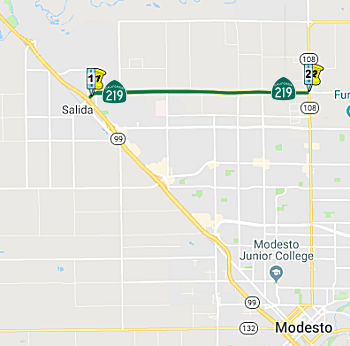
Stanislaus County Widening (STA 0.1 to STA 4.9)
 There are currently plans to widen this route in Stanislaus county. [May 2002 CTC Agenda, item 2.1b.(2); July 2002
CTC Agenda item 2.2c.(8)] According to the July and September 2006
agendas, the project, as currently scoped, will widen Route 219 to four
lanes from PM STA 0.1 to STA 4.9. In March 2005, an updated cost estimate
placed R/W capital at $42 million and Construction capital at $33 million.
The increase in R/W was due to the rise in property values, including the
right of way needed to accommodate estimated traffic capacity based on an
updated traffic analysis. Due to funding constraints, and the result of a
Value Analysis Study, the Department of Transportation, StanCOG, and local
officials reduced the scope of the project by splitting it into two
phases. Phase 1 will extend from PM 0.1 to 2.9 and be fully programmed
through construction. The scope of the work for Phase 1 includes acquiring
right of way for an ultimate six- lane facility, widening the highway from
two to four- lanes, and upgrading intersections with local roads. As part
of the intersection improvements, an additional receiving lane and a
right-turn lane will be added at the intersection of Route 219 and Sisk
Road. Phase 1 will be ready for construction during the Summer of 2007.
Phase 2 will extend through the remainder of the original scope, from PM
2.9 to 4.9, and be funded at a later date. In 2007, the Corridor Mobility
Improvement Account (CMIA) was recommended to fund $14,760K to widen this
route to 4-lanes from Route 99 to Marrow Rd, and $18,813K to widen the
route to four lanes from Marrow Rd to Route 108. In June 2008, the CTC
approved reducing Regional Improvement Program (RIP) Right of Way Capital
funds from $17,000,000 to $14,760,000 ($2,240,000 decrease) and increasing
federal Demonstration (Demo) Right of Way Capital funds from $0 to
$2,240,000 ($2,240,000 increase). The RIP funds would be programmed and
allocated to the Route 219 Expressway, Phase 1A project so that the
construction phase can commence. Federal Demo funds, which are programmed
for construction of the Route 219 Expressway Phase 1A project but are
temporarily unavailable, will be reprogrammed to the Route 219 Expressway
Phase 2 project so that it remains fully funded.
There are currently plans to widen this route in Stanislaus county. [May 2002 CTC Agenda, item 2.1b.(2); July 2002
CTC Agenda item 2.2c.(8)] According to the July and September 2006
agendas, the project, as currently scoped, will widen Route 219 to four
lanes from PM STA 0.1 to STA 4.9. In March 2005, an updated cost estimate
placed R/W capital at $42 million and Construction capital at $33 million.
The increase in R/W was due to the rise in property values, including the
right of way needed to accommodate estimated traffic capacity based on an
updated traffic analysis. Due to funding constraints, and the result of a
Value Analysis Study, the Department of Transportation, StanCOG, and local
officials reduced the scope of the project by splitting it into two
phases. Phase 1 will extend from PM 0.1 to 2.9 and be fully programmed
through construction. The scope of the work for Phase 1 includes acquiring
right of way for an ultimate six- lane facility, widening the highway from
two to four- lanes, and upgrading intersections with local roads. As part
of the intersection improvements, an additional receiving lane and a
right-turn lane will be added at the intersection of Route 219 and Sisk
Road. Phase 1 will be ready for construction during the Summer of 2007.
Phase 2 will extend through the remainder of the original scope, from PM
2.9 to 4.9, and be funded at a later date. In 2007, the Corridor Mobility
Improvement Account (CMIA) was recommended to fund $14,760K to widen this
route to 4-lanes from Route 99 to Marrow Rd, and $18,813K to widen the
route to four lanes from Marrow Rd to Route 108. In June 2008, the CTC
approved reducing Regional Improvement Program (RIP) Right of Way Capital
funds from $17,000,000 to $14,760,000 ($2,240,000 decrease) and increasing
federal Demonstration (Demo) Right of Way Capital funds from $0 to
$2,240,000 ($2,240,000 increase). The RIP funds would be programmed and
allocated to the Route 219 Expressway, Phase 1A project so that the
construction phase can commence. Federal Demo funds, which are programmed
for construction of the Route 219 Expressway Phase 1A project but are
temporarily unavailable, will be reprogrammed to the Route 219 Expressway
Phase 2 project so that it remains fully funded.
In December 2011, the CTC updated the project schedule, as the End Right of Way milestone was delayed by nine months in order to provide additional time for two property owners to relocate. Although Orders for Possession were secured several months ago, the right of way demolition and clearing process stalled because two property owners were building new houses behind their existing homes, which extended the relocation process. The Begin Construction milestone is being delayed by 18 months, nine months of which is a direct result of the right of way delay described above. The other nine months of delay is due to a mistake in the original schedule, which proposed starting construction two months before the End Right of Way milestone. It is more realistic for construction to begin seven months after the End Right of Way milestone. The End Construction milestone is being delayed by 30 months, 18 months of which is a direct result of the begin construction delay described above. The other 12 months of delay is from a thorough analysis of the construction working days. A construction duration of 12 months was unrealistic. A construction duration of 24 months is more realistic based on the final plans and stage construction requirements. The Begin Closeout milestone is being delayed by 30 months because it is directly related to the End Construction milestone, which is being delayed by 30 months as described above. The End Closeout milestone is being delayed by 41 months, 30 months of which is a direct result of the Begin Closeout delay described above. The other 11 months of delay is caused by a mistake in the original schedule, which showed a duration of one month for Closeout. Closeout requires a duration of 12 months. The net result is that the proposed end of construction is 5/31/2014, with project closeout proposed for 7/31/2015.
In December 2011, the CTC authorized $23.76 million for phase 2 of the Route 219 Widening near Salida, from Morrow Road to Route 108. Widen to 4 lanes.
In December 2011, the CTC authorized relinquishment of right of way in the county of Stanislaus along Route 219 from Kiernan Court to Dale Road (~ STA 0.28 to STA 1.854), consisting of collateral facilities.
In January 2017, the CTC authorized relinquishment of right of way in the county of Stanislaus along Route 219 on American Avenue, Morton Road, Carver Road, Tully Road, Tunsen Road, and Claribel Road to Route 108 (10-Sta-219 PM 2.35/4.86, roughly between Soddard and American), consisting of collateral facilities. The County, by Board of Supervisors Action No. 2016-535 dated October 25, 2016 agreed to waive the 90-day notice requirement and accept title upon relinquishment by the State.
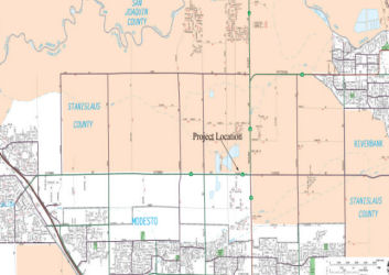
North County Corridor (~ 10-STA-219 PM 3.7/4.8)
The SAFETEA-LU act, enacted in August 2005 as the reauthorization of TEA-21, provided the following expenditures on or near this route (although these expenditures seem to be more for Route 108):
![[108 Oakdale]](maps/108-oakdale.jpg) In May 2010, the CTC approved for future consideration of funding a project in Stanislaus County that would
study corridor options for a future alignment of Route 108 near the city
of Oakdale. There is no construction for this project because it is for
route adoption only. Once the route adoption is approved by the
Commission, and funding becomes available, the Stanislaus Council of
Governments and the Department will conduct further environmental studies
to identify a roadway alignment within the selected corridor. The
construction of the new roadway is anticipated to occur in Fiscal Year
(FY) 2025. Conceptual level cost estimates to build a new roadway range
from $600 to $800 million (FY 2009 costs), and $1.3 to $1.5 billion (FY
2030 costs). It is expected that the future project, however, will have
potential impacts to land use, farmlands, cultural resources, biological
resources, relocations, hazardous waste, water quality, paleontology, and
air quality.
In May 2010, the CTC approved for future consideration of funding a project in Stanislaus County that would
study corridor options for a future alignment of Route 108 near the city
of Oakdale. There is no construction for this project because it is for
route adoption only. Once the route adoption is approved by the
Commission, and funding becomes available, the Stanislaus Council of
Governments and the Department will conduct further environmental studies
to identify a roadway alignment within the selected corridor. The
construction of the new roadway is anticipated to occur in Fiscal Year
(FY) 2025. Conceptual level cost estimates to build a new roadway range
from $600 to $800 million (FY 2009 costs), and $1.3 to $1.5 billion (FY
2030 costs). It is expected that the future project, however, will have
potential impacts to land use, farmlands, cultural resources, biological
resources, relocations, hazardous waste, water quality, paleontology, and
air quality.
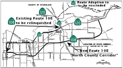
Specifically, the proposal is to modify the adopted route for Route 108 in Stanislaus County, in the vicinity of the cities of Modesto, Riverbank, and Oakdale. The ultimate facility is planned as a multi-lane freeway/expressway corridor, approximately 18 miles long. A Project Report was approved on April 13, 2010. An Environmental Impact Report was prepared for California Environmental Quality Act and the document was approved on April 13, 2010. This 18 mile long project, referred to as the North County Corridor (NCC) Route 108 East Route Adoption, will bypass the cities of Riverbank and Oakdale, improve interregional system connectivity, and improve regional traffic operations.
Route 108 is generally classified as a minor arterial through most of the project limits except for sections through the cities of Riverbank and Oakdale that are classified as principal arterial. Existing Route 108 functions as a “main street” and is predominantly a two-lane undivided conventional facility. Between the intersection of Route 108 (McHenry Avenue)/SR 219 (Kiernan Avenue) and the intersection of Route 108/Route 120 with Lancaster Road, Route 108 is encumbered by 83 public street intersections and many private driveways with direct access onto Route 108. It is highly congested during peak travel times and these conditions are expected to worsen as traffic volumes on Route 108 increase in the foreseeable future. Increasing levels of traffic on both Route 120 and Route 108 into and through the City of Oakdale have led to a growing traffic congestion problem that the Department and the local community have been addressing for over five decades. Traffic on Route 108 includes a combination of commuter, local commerce, goods movement, agricultural and farm operations, and a large component of interregional recreational traffic. This elevated interregional traffic demand often conflicts with local traffic demand resulting in congestion, increased noise and air pollution. Route 108 provides direct access to local residences, farms, and other community facilities along its route but also travels through the busy downtown areas of Oakdale and Riverbank. Congestion is most severe during weekends due to recreational traffic traveling to Yosemite National Park, and to the Jamestown and Sonora areas. Weekdays can also be very congested due to the heavy commute traffic. The area most severely affected by congestion is at the junction of Route 108 and Route 120 (Yosemite Avenue) in downtown Oakdale where the level of service (LOS) in 2001 was classified as “F”, representing heavily congested traffic with long delays. These conditions are expected to worsen over time as development continues and traffic volumes increase. The LOS is projected to degrade to “very high delays” by the year 2020 in the absence of any system improvement.
 The ultimate facility is planned as a multi-lane freeway, approximately ten miles long, from Route 219 and McHenry Avenue to just east of Albers Road and as a multi-lane
controlled access highway for the remaining eight miles until it connects
with Route 120, approximately six miles east of the City of Oakdale. The
freeway segment will serve the urban areas of Modesto, Riverbank, and
Oakdale. The controlled access highway segment is planned for the rural
area of Stanislaus County south-east of Oakdale. The route adoptions will
be executed as two concurrent CTC actions on this month’s agenda
(see also Resolution HRA 10-03). Although the North County Corridor
encompasses a roadway facility between Route 99 and Route 120, the
proposed State route adoption is only for the segment between Route 108
(McHenry Avenue) and Route 120. These limits are a result of discussions
occurring June 2008 to February 2009 between State and local entities. A
freeway adoption connecting to Route 99 was interfering with the
development of a modification proposal at the Hammett Road/Route 99
interchange. The Project Study Report for that project has assumed Hammett
would remain a local road and proposes a local type interchange at Route 99. The Department concurred to pursue evaluating the new NCC Route 108
East Route Adoption. This request is for the Freeway Route Adoption, and a
separate request is being submitted for the Controlled Access Highway
Route Adoption (Resolution HRA 10-03). These two route adoptions will
allow for the execution of a freeway agreement and a controlled access
highway agreement with Stanislaus County.
The ultimate facility is planned as a multi-lane freeway, approximately ten miles long, from Route 219 and McHenry Avenue to just east of Albers Road and as a multi-lane
controlled access highway for the remaining eight miles until it connects
with Route 120, approximately six miles east of the City of Oakdale. The
freeway segment will serve the urban areas of Modesto, Riverbank, and
Oakdale. The controlled access highway segment is planned for the rural
area of Stanislaus County south-east of Oakdale. The route adoptions will
be executed as two concurrent CTC actions on this month’s agenda
(see also Resolution HRA 10-03). Although the North County Corridor
encompasses a roadway facility between Route 99 and Route 120, the
proposed State route adoption is only for the segment between Route 108
(McHenry Avenue) and Route 120. These limits are a result of discussions
occurring June 2008 to February 2009 between State and local entities. A
freeway adoption connecting to Route 99 was interfering with the
development of a modification proposal at the Hammett Road/Route 99
interchange. The Project Study Report for that project has assumed Hammett
would remain a local road and proposes a local type interchange at Route 99. The Department concurred to pursue evaluating the new NCC Route 108
East Route Adoption. This request is for the Freeway Route Adoption, and a
separate request is being submitted for the Controlled Access Highway
Route Adoption (Resolution HRA 10-03). These two route adoptions will
allow for the execution of a freeway agreement and a controlled access
highway agreement with Stanislaus County.
Relinquishment of the existing Route 108 will occur after construction of the new bypass. Relinquishment will transfer the State’s right of way, title, and interest of the superseded section of Route 108 to the City of Oakdale, City of Riverbank, and Stanislaus County as depicted in the attached Route Adoption Map.
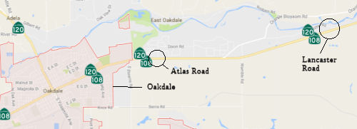 In September 2016, it was reported that one of the last
remaining battles over potential paths for the future North County
Corridor may be nearing an end, with momentum building for a tie-in with
existing Route 108 east of Oakdale at Lancaster Road. Dozens of families
in neighborhoods four miles to the west for months have protested the
concept of a roundabout at Atlas Road, with the North County Corridor
shooting south from that point and paralleling Stearns Road before
skirting Oakdale and running between Riverbank and Modesto. Oakdale
officials previously preferred the Atlas tie-in, thinking it might funnel
cars near a future shopping center; however, the city has changed its mind
and has adopted a resolution supporting the neighbor-preferred Lancaster
option. The EIR should be released in January 2017. Controversy over the
road’s western stretch, between Modesto and Riverbank, died down a
few years ago as engineers focused on redoing Kiernan Avenue, with
legitimate freeway interchanges at McHenry Avenue, Coffee and Oakdale
roads, and Roselle Avenue. If Caltrans picks the Lancaster tie-in on the
east end, the only unresolved choice would be south of Oakdale, with one
option close to the south edge of the city and the other further south,
largely focused on Claribel Road. Leaders of the county and three cities
would review the draft environmental study around March, accepting input
from the public and seeking consensus among each other. Caltrans’
final route selection could follow in early 2018.
In September 2016, it was reported that one of the last
remaining battles over potential paths for the future North County
Corridor may be nearing an end, with momentum building for a tie-in with
existing Route 108 east of Oakdale at Lancaster Road. Dozens of families
in neighborhoods four miles to the west for months have protested the
concept of a roundabout at Atlas Road, with the North County Corridor
shooting south from that point and paralleling Stearns Road before
skirting Oakdale and running between Riverbank and Modesto. Oakdale
officials previously preferred the Atlas tie-in, thinking it might funnel
cars near a future shopping center; however, the city has changed its mind
and has adopted a resolution supporting the neighbor-preferred Lancaster
option. The EIR should be released in January 2017. Controversy over the
road’s western stretch, between Modesto and Riverbank, died down a
few years ago as engineers focused on redoing Kiernan Avenue, with
legitimate freeway interchanges at McHenry Avenue, Coffee and Oakdale
roads, and Roselle Avenue. If Caltrans picks the Lancaster tie-in on the
east end, the only unresolved choice would be south of Oakdale, with one
option close to the south edge of the city and the other further south,
largely focused on Claribel Road. Leaders of the county and three cities
would review the draft environmental study around March, accepting input
from the public and seeking consensus among each other. Caltrans’
final route selection could follow in early 2018.
(Source: Modesto Bee, 9/22/2016)
The August 2017 Draft EIR noted: The proposed project
will connect Route 219 near Modesto to Route 120 near Oakdale. This
environmental document analyzes the four Build Alternatives (1A, 1B, 2A,
and 2B) and the NoBuild Alternative. The western end of all alternatives
is at the Route 219 (Kiernan Avenue)/Tully Road intersection. The project
is analyzed as three distinct segments for environmental evaluation
purposes and explaining the proposed improvements. Segment 1 represents
the more urbanized area; Segment 2 represents a transition from urbanized
to rural area; and Segment 3 represents the rural foothill area.
(Source: NCC DEIR August 2017)
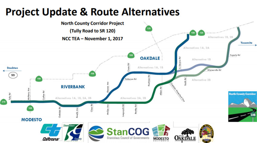 Segment 1 begins at the Route 219 Kiernan Avenue/Tully Road intersection, which is
the western end of the project for all four alternatives. All of the Build
Alternatives proceed along the same alignment, extending to the existing
Claus Road/Claribel Road intersection near the southeast portion of the
City of Riverbank and northeast portion of the City of Modesto’s
future sphere of influence, including future areas projected to be
incorporated into the City boundaries. The following
interchange/intersection designs are common to all Build Alternatives for
Segment 1: (◆) Tully Road/Route 219 (Kiernan Avenue) intersection
will consist of a modified signalized at-grade intersection; (◆)
Route 108 (McHenry Avenue)/Route 219, (Kiernan Avenue)/new Route 108,
Coffee Road/new Route 108, Oakdale Road/new Route 108, and Roselle
Avenue/new Route 108 will all consist of a proposed single-point urban
interchange and separate-grade undercrossing structures; (◆) The
Claus Road/new Route 108 signalized at-grade intersection will provide
access from the new Route 108 facility east of Claus Road as well as the
local road access to the City of Riverbank and future northeastern areas
of the City of Modesto.
Segment 1 begins at the Route 219 Kiernan Avenue/Tully Road intersection, which is
the western end of the project for all four alternatives. All of the Build
Alternatives proceed along the same alignment, extending to the existing
Claus Road/Claribel Road intersection near the southeast portion of the
City of Riverbank and northeast portion of the City of Modesto’s
future sphere of influence, including future areas projected to be
incorporated into the City boundaries. The following
interchange/intersection designs are common to all Build Alternatives for
Segment 1: (◆) Tully Road/Route 219 (Kiernan Avenue) intersection
will consist of a modified signalized at-grade intersection; (◆)
Route 108 (McHenry Avenue)/Route 219, (Kiernan Avenue)/new Route 108,
Coffee Road/new Route 108, Oakdale Road/new Route 108, and Roselle
Avenue/new Route 108 will all consist of a proposed single-point urban
interchange and separate-grade undercrossing structures; (◆) The
Claus Road/new Route 108 signalized at-grade intersection will provide
access from the new Route 108 facility east of Claus Road as well as the
local road access to the City of Riverbank and future northeastern areas
of the City of Modesto.
Segment 2 is where the four similar alternatives separate into two different alignments (1A/1B and 2A/2B). In Segment 2, Alternatives 1A and 1B veer northeast from near the existing Claus Road/Claribel Road intersection and pass through the southern boundary of the City of Oakdale to just east of Albers Road, and Alternatives 2A and 2B continue to extend easterly along Claribel Road and veer northeastward past the intersection of Claribel Road/Bentley Road to just east of Albers Road. In Segment 2:
In Segment 3, Alternatives 1A and 2A merge as similar alignments at the southern end of the City of Oakdale and continue on the same alignment to the proposed eastern end (A) at the new Route 108/Route 120 intersection just east of the City of Oakdale boundary. In Segment 3, Alternatives 1B and 2B merge as similar alignments north of the existing Warnerville Road/Emery Road intersection and continue on a northeasterly direction to the proposed other eastern end (B) at the new Route 108/Route 120 intersection west of the existing Route 120/Lancaster Road intersection. In Segment 3:
In November 2018, the Stanislaus County Public Works
Department noted that, on October 3, 2016, the Oakdale City Council passed
a resolution of preliminary support for NCC Alternatives 1B and 2B. With
the official release of the Draft EIR/EIS on August 9, 2017, City staff
has had the opportunity to review the Draft EIR/EIS and believes that
Alternative 1B should be the preferred alternative. At their September 18,
2017 meeting, the Oakdale City Council unanimously passed a resolution to
send Caltrans an official comment letter stating the City’s
preference for Alternative 1B. On October 24, 2017 City of Riverbank City
Council took the same action for similar reasons. The Riverbank City
Council unanimously passed a resolution adopting Alternative 1B as the
City’s preferred North County Corridor route Alignment.
(Source: Stanislaus County Public Works Presentation, 11/2018)
In December 2018, it was reported that Federal highway
officials approved a $20 million grant for the North County Corridor, a
future expressway skirting Modesto, Riverbank and Oakdale in north
Stanislaus County. The road is expected to cost $688 million and will
require additional funding. State transportation officials are expected to
pinpoint the exact route in early 2019, and construction could be a few
years away. The project was one of only four in California drawing BUILD
money, formerly known as TIGER grants; BUILD stands for Better Utilizing
Investments to Leverage Development. The corridor will be a west-east
facility from Route 108 (McHenry Avenue) north of the City of Modesto to
Route 120 approximately six miles east of the City of Oakdale. This new
roadway would be approximately 18 miles in length from a location on Route 219 (Kiernan Avenue) to a location on Route 120 approximately six miles
east of the City of Oakdale. The project may be an entirely new roadway or
incorporated into the existing roadway network and would serve as a bypass
for the cities of Riverbank, Oakdale and Modesto. The North County
Corridor Transportation Expressway Authority anticipates that the ultimate
facility would be planned as a multi-lane, access-controlled
expressway/freeway, with interchanges, at-grade intersections,
grade-separated railroad crossings, irrigation district crossings,
frontage roads, and local street alignments. Various roadway alignment
alternatives will be considered. The proposed roadway would be built in
existing unincorporated Stanislaus County. Funding for this phase of the
project is being provided by regional transportation impact fees and the
state funding that was once part of the cancelled state Oakdale Bypass
project.
(Source: Modesto Bee, 12/10/2018; NorthCounty
Corridor Webpage)
In June 2020, it was reported that the EIS for the
Route 108 Modesto bypass expressway, the first phase of which extends from
the Route 108/Route 219 junction north of Modesto to a terminus at present
Route 108/Route 120 east of Oakdale, has been approved. Stanislaus
County has a corridor design simulator that follows the facility, which is
being designed as a combination freeway/expressway, from west to
east. The routing has three roundabouts on the main expressway lanes
(3+3 on the west end; 2+2 east of Riverbank), along with several
interchanges at major arterials. Two of these are multi-lane; the
last one is at the eastern terminus as the connector to Route 120.
The expressway is designed to be upgradeable to full freeway (likely with
bridges over the circles); also, in a future phase this corridor will
follow Route 219 west to Route 99 near Salida.
(Source: Scott Parker on AARoads, "Re: California", 6/11/2020)
In December 2020, the CTC approved a route adoption and
future consideration of funding for the following project for which a
Final Environmental Impact Report (FEIR) has been completed: Route 108,
Route 219, and Route 120 in Stanislaus County (10-Sta-108, PM 27.5/44.5
• 10-Sta-219, PM 3.7/4.8 • 10-Sta-120, PM 6.9/11.6).
Construct a new freeway east of the City of Oakdale in Stanislaus County.
(PPNO 0228) This project is located on Route 108, Route 219, and
Route 120 in Stanislaus County, in the City of Modesto, City of Riverbank,
and City of Oakdale, from 0.1 mile west of the Route 219 (Kiernan
Avenue)/Tully Road Intersection in Stanislaus County to the new Route 108/Route 120 Junction east of the City of Oakdale. The purpose of this
project is to reduce average daily traffic volumes and traffic congestion
as well as accommodate anticipated future traffic on SR 108 and the
surrounding regional transportation network. This project is not fully
funded and the total project cost is $915,000,000. Construction is
estimated to begin in 2023.
(Source: December 2020 CTC Agenda, Agenda Item
2.2c.(1))
 Naming
 The portion of Route 219
between Route 99 and Route 108 in Stanislaus County (i.e., the entire
route) is officially designated the "CHP Officer Earl Scott Memorial
Highway". It was named in memory of California Highway Patrol
Officer Earl Scott. who was tragically shot and killed while making a
traffic stop on Route 99 in Stanislaus County on February 17, 2006.
Officer Scott was 36 years old and had served with the California Highway
Patrol (CHP) for five years. Officer Scott came from a long line of family
members who devoted themselves to public service under the auspices of the
CHP, including his father and two uncles who retired from the CHP as
sergeants, and a cousin who currently serves as a sergeant with the CHP.
Officer Scott is remembered as being the first to volunteer for such
causes as shaving his head for "Shave the Brave," a fundraiser for cancer
victims. Officer Scott also frequently took youth Law Enforcement
Explorers on ride-alongs. Officer Scott touched many lives and leaves
behind many fellow officers whose friendship with Officer Scott was more
akin to being a family. Named by Assembly Concurrent Resolution 31,
Resolution Chapter 47, on July 11, 2011.
The portion of Route 219
between Route 99 and Route 108 in Stanislaus County (i.e., the entire
route) is officially designated the "CHP Officer Earl Scott Memorial
Highway". It was named in memory of California Highway Patrol
Officer Earl Scott. who was tragically shot and killed while making a
traffic stop on Route 99 in Stanislaus County on February 17, 2006.
Officer Scott was 36 years old and had served with the California Highway
Patrol (CHP) for five years. Officer Scott came from a long line of family
members who devoted themselves to public service under the auspices of the
CHP, including his father and two uncles who retired from the CHP as
sergeants, and a cousin who currently serves as a sergeant with the CHP.
Officer Scott is remembered as being the first to volunteer for such
causes as shaving his head for "Shave the Brave," a fundraiser for cancer
victims. Officer Scott also frequently took youth Law Enforcement
Explorers on ride-alongs. Officer Scott touched many lives and leaves
behind many fellow officers whose friendship with Officer Scott was more
akin to being a family. Named by Assembly Concurrent Resolution 31,
Resolution Chapter 47, on July 11, 2011.
(Image sources: Modesto Bee; Find a Grave)
 Other WWW Links
 Statistics
Overall statistics for Route 219:
 Pre-1964 Legislative Route
This route number appears not to have been assigned by the California Legislature before the 1963 renumbering.
© 1996-2020 Daniel P. Faigin.
Maintained by: Daniel P. Faigin
<webmaster@cahighways.org>.
 From Route
  Route 218
 Route 220