
 California Highways:
Click here for a key to the symbols used. An explanation of acronyms may be found at the bottom of the page.
 Routing
 Post 1964 Signage History
 In 1963, Route 241 was defined as the route “Route 11 near
Adams Street to Route 11 near Elysian Park in Los Angeles.” Route 11
is present-day Route 110. This was to be the "East Bypass".
In 1963, Route 241 was defined as the route “Route 11 near
Adams Street to Route 11 near Elysian Park in Los Angeles.” Route 11
is present-day Route 110. This was to be the "East Bypass".
In 1965, Chapter 1372 repealed this routing.
In 1968, Chapter 282 created a new definition of Route 241 as
“…in San Francisco from Route 1 to Route 101 near Fell and Oak
Streets.” This routing was the result of a transfer from Route 80.
This was to be part of the Panhandle Freeway.
In 1972, Chapter 1216 deleted this definition of Route 241.
 During 1986, the Transportation Corridors Agencies (TCA) of Orange County were created. Corridors
governed by the TCA included: the Eastern Transportation Corridor,
Foothill Transportation Corridor and San Joaquin Hills Transportation
Corridor. 1987 Legislative Chapter 1413 allowed for transportation
corridors to be constructed by way of toll funds. The Eastern
Transportation Corridor was assigned as Route 231, and was originally
defined as "Route 5 near the border of the Cities of Tustin and Irvine to
Route 91." At this point, the TCA routes were Route 231 (I-5 near
Tustin/Irvine to Route 91 roughly along Jamboree Road) and Route 241 (I-5
near San Clemente to Route 231 near Santiago Canyon Road (County Sign Route S18) near
Irvine Lake). Route 133 was not part of the TCA system.
During 1986, the Transportation Corridors Agencies (TCA) of Orange County were created. Corridors
governed by the TCA included: the Eastern Transportation Corridor,
Foothill Transportation Corridor and San Joaquin Hills Transportation
Corridor. 1987 Legislative Chapter 1413 allowed for transportation
corridors to be constructed by way of toll funds. The Eastern
Transportation Corridor was assigned as Route 231, and was originally
defined as "Route 5 near the border of the Cities of Tustin and Irvine to
Route 91." At this point, the TCA routes were Route 231 (I-5 near
Tustin/Irvine to Route 91 roughly along Jamboree Road) and Route 241 (I-5
near San Clemente to Route 231 near Santiago Canyon Road (County Sign Route S18) near
Irvine Lake). Route 133 was not part of the TCA system.
 This was codified in 1988, when Chapter 1363 created a new definition of Route 241 as “Route 231 near the Cities
of Tustin and Irvine to Route 5 south of San Clemente.”
This was codified in 1988, when Chapter 1363 created a new definition of Route 241 as “Route 231 near the Cities
of Tustin and Irvine to Route 5 south of San Clemente.”
In 1991, Route 133 was brought into
the TCA system, bringing changes to the route definitions. SB 732, Chapter
775 created a new definition of Route 261 as “Route 5 near the
border of the Cities of Tustin and Irvine to Route 231”, using a
routing transferred from former Route 231. Route 231 was changed to run
from the end of Route 133 to Route 91. Route 241 was truncated to run from
the Route 231/Route 241 junction near Bee Canyon and Limestone Canyon Park
to I-5. The legislative definition of Route 241 didn't need to change, as
the western end remained Route 231.
Route 241 between Portola Parkway in Irvine south to Antonio Parkway in
Rancho Santa Margarita initially opened in two segments: a 3.2-mile
segment on October 16, 1993 and a 4.3-mile segment on April 7, 1995.
(Source: Gribblenation Blog (Tom Fearer), "California State Route 241", 1/21/2022)
In 1996, Chapter 1154 extended Route 241 by transfer
from former Route 231: “Route 5 south of San Clemente to Route 91 in the City of Anaheim Route 231 near the Cities of
Tustin and Irvine”. At the same time, Route 261 was
changed to have a more specific start, and to end at the extended Route 241: At the same time, Route 231 was dropped making Route 241 became the
main backbone. Route 133 was extended to take over the former portion of
Route 231 between Laguna Canyon and Route 241.
In 1998, additional segments opened: the northernmost end of the
Foothill-North segment to Route 133 in addition to the eastern
Transportation Corridor north to Route 91. Route 241 was extended south to
Oso Parkway in 1999 which completed the Foothill-North segment.
(Source: AARoads, Route 241 Page)
Route 241 consists of three transportation corridors: Eastern, Foothill North, and Foothill South:
At Hicks Haul Road (~ ORA 28.662) there is a bridge to the W of the
freeway. This bridge was part of a planned interchange with Jeffrey
Road.This interchange was part of the original planning for the Eastern
Transportation Corridor, and is included as a Future Capital Project
(post-2025) in the 2020 Planning Document. F/ETCA, There is currently a
study effort to evaluate an interchange at Jeffrey Road and Route 241 as a
potential access point to the Frank R. Bowerman Landfill from Route 241.
The extension of Jeffrey Road, north of Portola Parkway to Route 241, is
included in the County of Orange Master Plan of Arterial Highways (MPAH).
This interchange was included in the original Eastern Transportation
Corridor environmental document. If this project moves beyond the study
phase, the project will be programed for environmental planning, design,
and construction.
(Source: FB Comment by Cary Thomas Bellaflor in the Freeways of Los Angeles FB Group, 11/1/2020, 2020 Fiscal Capital Improvement Plan, 6/13/2019)
 Pre 1964 Signage History
The 1964-1965 incarnation of Route 241 (from 1964 Route 11 near Adams Street to 1964 Route 11 near Elysian Park) was a proposed LRN 222 that would have sliced through the heart of downtown Los Angeles running E of Main Street. It was never constructed, and is no longer part of the state highway system.
The 1968-1972 incarnation of Route 241 (from Route 1 to Route 101 near Oak and Fell Streets in San Francisco) was LRN 223, defined in 1947.
The post-1988 routing of Route 241 was not defined in 1963.
 Status
Foothill South Completion (~ ORA 0.000 to ORA 14.545)
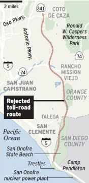
In the early 2000s, the Foothill South alignment had two possibilities under consideration: a locally preferred alignment east of the City of San Clemente and traversing the undeveloped San Onofre State Beach Park portion of the Camp Pendleton Marine Corps Base, or an alternative alignment generally 2½ miles westerly of the locally preferred alignment (near La Pata and Avendia Pico). Future interchanges include Oso Parkway, Crown Valley Parkway, Ortega Highway, Avenida Pico and Christianitos Road. It terminates at Interstate 5 in San Diego County just south of Basilone Road.
The SAFETEA-LU act, enacted in August 2005 as the reauthorization of TEA-21, provided the following expenditures on or near this route:
 In December 2005, the Foothill/Eastern Transportation Corridor Agency released its final
environmental impact report on the alignments. They chose a wilderness
route for the Foothill South, which could be completed as early as 2010.
The agency's chosen route, one of six possibilities outlined in May,
traverse the habitat for at least 10 threatened or endangered species and
cut a state park in half. The roadway would be raised on pillars near the
coast and would be visible from the coastal side of San Onofre State
Beach. Although toll-road officials say it would have no direct effect on
surfing, species or habitat near the beach, activists say it would spoil
coastal views and ruin the ambience of the state park's campground. A
state parks commission recently called on state officials to fight the
toll road. The toll-road board votes on the proposal Jan. 12, 2006. Then,
the agency must gain permits from a variety of agencies, including the
U.S. Fish and Wildlife Service, the U.S. Army Corps of Engineers, and the
state Department of Fish and Game, as well as the state Coastal
Commission.
In December 2005, the Foothill/Eastern Transportation Corridor Agency released its final
environmental impact report on the alignments. They chose a wilderness
route for the Foothill South, which could be completed as early as 2010.
The agency's chosen route, one of six possibilities outlined in May,
traverse the habitat for at least 10 threatened or endangered species and
cut a state park in half. The roadway would be raised on pillars near the
coast and would be visible from the coastal side of San Onofre State
Beach. Although toll-road officials say it would have no direct effect on
surfing, species or habitat near the beach, activists say it would spoil
coastal views and ruin the ambience of the state park's campground. A
state parks commission recently called on state officials to fight the
toll road. The toll-road board votes on the proposal Jan. 12, 2006. Then,
the agency must gain permits from a variety of agencies, including the
U.S. Fish and Wildlife Service, the U.S. Army Corps of Engineers, and the
state Department of Fish and Game, as well as the state Coastal
Commission.
In late February 2006, the TCA selected the routing that traverses San Onofre State Beach. This created even more controversy, with bills being introduced in the state legislature to prohibit construction of toll roads in state parks. Specifically, in April 2007, AB 1457 (Huffman), which would ban a proposed toll road through San Onofre, was scheduled for a hearing before the Assembly Water, Parks and Wildlife Committee, was put on a two-year track in order to provide time to grow support to get it through the Legislature. Supporters of the road include such groups as the Associated General Contractors of California, the Orange County Business Council, the Los Angeles-Orange County Building and Construction Trades Council and local elected officials.
There is some controversy on this routing. a coalition of environmental groups opposed to the project has released a pair of studies that question the accuracy of study. Several environmental groups have rallied to support the California Department of Parks in its opposition to the proposed route through two federally-owned parklands . Each possible route was judged by the number of homes and businesses to be seized by eminent domain. The also compared construction of the route to widening I-5.
In November 2006, the LA Times reported that new traffic studies contradict optimistic predictions that a proposed tollway through San Onofre State Beach would eliminate much of the congestion on I-5 in South Orange County. Most of I-5 in South Orange County will be "consistently congested" at rush hour by 2030 even if the controversial Foothill South toll road extension is built, according to the Orange County Transportation Authority's long-range transportation plan for 2006. The forecasts assume construction of the tollway, a carpool lane each way on the I-5 and some interchange improvements. If only the tollway is built, the study suggests, the situation will be even worse, with motorists on the interstate seeing "severely congested" conditions.
In May 2007, efforts to extend the route were dealt a setback when a congressional committee voted to eliminate legislation designed to expedite the highway’s construction--specifically, approved a defense bill amendment related to Route 241 that would overrule a 1999 decision by Congress that gave the Navy the power to grant tollway operators a 40-acre easement inside San Onofre (as the park is on leased land within USMC Pendleton). The amendment would also dismantle other federal legislation freeing Route 241 from regulations in the federal Transportation Act requiring road builders to exhaust all "feasible and prudent" alternatives before parkland can be used for a highway. During the summer this amendment stalled, but as of December 2007, it had passed all procedural challenges and made it into the defense authorization bill. Note that the project can't be built unless the state Coastal Commission grants a permit for its construction, and a commission staff report issued in September 2007 already has recommended that the permit be denied.
In February 2008, the California Coastal Commission denied the construction permit, and the OCTA began consideration of a new route.
In December 2008, the U.S. Commerce Department announced it would uphold the state Coastal Commission's rejection of the plan. Federal officials could only override the state's decision if the project had no alternatives or was necessary to national security, and the announcement said neither of those criteria was met. The California Coastal Commission rejected plans for the road earlier in 2008, saying that the six-lane road -- which would run from Rancho Santa Margarita to Basilone Road at Camp Pendleton -- violated the state's coastal management program. The toll road agency backing the plan "may pursue another route" consistent with coastal zone protections, according to the Commerce Department announcement.
In June 2009, it was reported that the toll road agency still wants to complete the connection to I-5, and is considering other routes. The agency has budgeted $11.9 million for "241 completion" in its fiscal year that begins July 1. The rejected route would have extended Route 241 by 16.9 miles, from its current terminus in the Rancho Santa Margarita area through San Onofre State Beach park to join I-5. Since the U.S. Commerce Department rejected the proposed route in December, the toll road agency's staff has reached out to supporters and opponents in dozens of meetings to see if agreement can be reached on an alternate route. While opponents say planners should look at options besides extending the toll road, the toll road agency feels a failure to extend Route 241 would force a "massive widening" of I-5 from the San Diego County line north to Laguna Hills.
In December 2009, San Clemente city council members said they expect to vote in January on a resolution opposing a toll road into San Clemente. This came about due to discussions that TCA had with federal officials about alternative routes that would cut through San Clemente. There are two potential routes of concern to the city: the Commerce Department's option, which would end at Avenida La Pata and Avenida Vista Hermosa, dumping traffic there, and a longer route that would connect with I-5 beside Avenida Pico. The TCA has declared the Commerce Department's option unfeasible, and with respect to alternative routes within Camp Pendleton, the Marines are on record as far back as 1990 stating that the route through the state park was the only one acceptable to the Marine Corps.
In May 2011, it was reported that TCA was attempting again to rally public opinion for construction of the route. The TCA is trying to re-establish a Route 241 proposal three years after the California Coastal Commission rejected a previous plan and the U.S. secretary of commerce rejected the TCA's appeal. TCA has run advertisements appealing for public support. The specifics of their alternate route have not been released.
In October 2011, the TCA voted to conduct a $3.9-million feasibility study for an addition that would run from Oso Parkway in Rancho Santa Margarita to the vicinity of Ortega Highway. If approved, construction could begin in early 2013. The study is expected to take a year, and will consider environmental effects, finances and engineering.
In November 2012, it was reported that the OCTA had approved more work on the extension of Route 241. Although there is still no movement regarding completing the extension to I-5, TCA is planning an addition that would bring the road's southern end to just north of Ortega Highway. The Tesoro extension is estimated to cost around $195 million, and TCA is working on attaining right-of-ways with Rancho Mission Viejo, which owns the land and is developing homes on the property. The project will go to a regional water board hearing in February 2013 and a community forum in March before a TCA board vote.
In April 2013, it was reported that due of the weakened
financial condition of OCTA, a new study recommends that its leadership
postpone a road project and stop borrowing money until state authorities
can review the operation. In December 2012, SNR Denton, a Los Angeles law
firm that helped stop the TCA from building a route through San Onofre
State Park, disclosed documents that revealed a host of issues plaguing
the agency. They included sagging ridership and revenue as well as
mounting debts and declining ratings for bonds sold to investors. The
institute’s report also coincides with plans by the California Debt
and Investment Advisory Commission to assess the viability of a proposed
refinancing of $2.4 billion in TCA bonds. The new study agrees with many
of Denton’s findings, but it goes one step further in recommending
that the TCA halt the refinancing and shelve a proposed tollway project in
southern Orange County until the agency’s finances are vetted.
Tollway officials said the issues raised by the new study are “old
news regenerated by some of the same opposition groups” to TCA
projects. They noted that the operation has a quarter million riders
daily, earns about $200 million in annual revenue and has not missed a
debt payment. The report states that to make its debt payments, the TCA
has raised tolls so much that its debt per mile is now far higher than the
national average for toll roads. The Foothill-Eastern’s is $64
million, while the San Joaquin’s is $136 million. The national
average is $17.1 million, the study notes. Almost a quarter of the
TCA’s total debt payments of more than $10 billion stem from capital
appreciation bonds that delay principal and interest payments for years
and can result in huge debt payments. As such, tolls for both corridors
are now among the highest in the country, researchers said, causing many
price-sensitive motorists to avoid them in favor of free public highways.
(Source: LA Times, 4/10/13)
In June 2013, it was reported that the San Diego Regional Water Quality Control Board declined to issue a discharge permit to the Transportation Corridor Agencies in Irvine, the operator of 51 miles of toll roads in Orange County. The TCA sought the permit for the planned Tesoro Extension that would lengthen the Foothill tollway 5.5 miles from Oso Parkway in Rancho Santa Margarita to Cow Camp Road east of San Juan Capistrano. Board members who voted to deny the permit said the Tesoro Extension was not the project that should have been brought to them for a permit. They contended that the proposal was actually part of a broader TCA plan to lengthen the Foothill toll road 16 miles to I-5 around San Clemente.
In April 2014, it was reported that the TCA has announced that it has canceled environmental studies for a controversial extension project that was widely criticized and ultimately rejected by the California Coastal Commission in 2008. The Transportation Corridor Agencies rescinded two notices to proceed with federal environmental impact statements for the Foothill South extension, which would have connected the Route 241 tollway with the I-5 Freeway south of San Clemente.
In March 2015, it was reported that the San Diego
Regional Water Quality Control Board declined to issue the waste discharge
permit that was needed before construction can begin on the controversial
extension project. It was the second time since June 2013 that the water
board has rejected a discharge permit for the planned Tesoro Extension
that would add 5.5 miles to the Foothill tollway by extending it from Oso
Parkway in Rancho Santa Margarita to Cow Camp Road east of San Juan
Capistrano. Citing substantial evidence, the board asserted that the
Tesoro was actually part of a broader TCA plan to extend the Foothill
tollway 16 miles to the 5 Freeway around San Clemente. As a result, the
board concluded that potential effects on water quality of the proposed
extension were not adequately addressed and unmitigated effects could
occur if the Foothill tollway is eventually built.
(Source: LA Times, 3/17/2015)
In November 2016, it was reported that Orange County
tollway officials agreed in a legal settlement in November 2016 to
preserve San Onofre State Beach and withdraw their approval of a six-lane
highway through the popular park. The new agreement ends five lawsuits
that targeted plans to lengthen the Foothill South toll road 16 miles to
I-5 in north San Diego County, using a portion of the state beach, which
includes wildlife habitat, campgrounds, Indian sites and heavily used surf
breaks, including Trestles. The settlement also requires the
Transportation Corridor Agencies in Irvine to rescind approval of the
proposed 5½-mile Tesoro Extension, which environmentalists called a
possible attempt to resurrect the route through San Onofre. Agency board
members voted 10-2 to end the lawsuits brought in 2006 and 2011 by the
state of California, the California Parks and Recreation Commission, the
Native American Heritage Commission and the Save San Onofre Coalition. The
lawsuits claimed that the environmental impact reports for both projects
were inadequate and that the Foothill South extension would damage
valuable open space, a local land conservancy and one of the most popular
parks in the state. The settlement will allow the corridor agency to
consider a variety of transportation options, including a different
Foothill South project, while protecting San Onofre, the San Mateo Creek
watershed, the Richard and Donna O’Neill Conservancy and Indian
sites, such as the ancient village of Panhe. Under the agreement, the
agency can assess the environmental impacts of alternate routes for
connecting the Foothill tollway to I-5 that avoid San Onofre, valuable
open space, wildlife habitat and culturally sensitive areas. The
settlement also calls for the agency to create a $28-million conservation
fund that will help preserve the largely intact San Mateo Creek watershed
that drains into the ocean at Trestles, one of the state’s best
surfing spots.
(Source: LA Times, 11/9/2016)
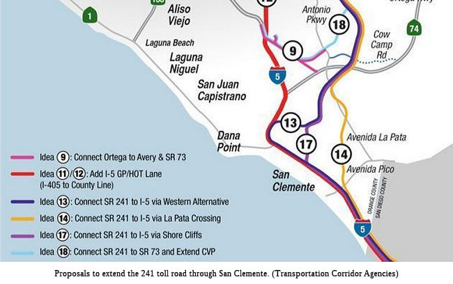 In September 2017, it was reported that the Mayor of San
Clemente just realized that a toll road that the Transportation Corridor
Agency is considering merging onto I-5 near Avenida Pico would fly over a
former Carrows Restaurant that borders San Clemente High School. Mayor
Kathy Ward, who represents the city on the TCA’s board of directors,
said she was given a tour of potential south Orange County toll road
routes that are part of a TCA mobility study. She said she was shocked to
see how close an envisioned bridge onto I-5 would pass the high school.
Ward said she had thought, based on a decade-old TCA environmental study,
that a potential Route 241 alignment would hug a hillside below St.
Andrews Methodist Church and descend to I-5 at the Pico interchange. Mike
Chesney, chief strategy officer for the TCA, said Wednesday, Sept. 6, that
the environmental process will need to vet any alignments that might be
proposed as a result of the mobility study. But at this point he said it
appears the potential alignment shown to Mayor Ward could be designed
without physical impacts to the high school. San Clemente’s City
Council has declared its opposition to any toll road slicing through the
city. The city’s website states opposition to any toll road that
would divide a community. The city and a homeowner association are suing
the TCA, challenging a protective zone that was created in a lawsuit
settlement the TCA reached in November 2016 with environmental groups. The
city says the avoidance zone, designed to protect the area around Trestles
Beach, cornered the TCA into trying to push Route 241 through one
established community or another in south Orange County to connect to I-5.
Mark McGuire, a San Clemente attorney who has questioned Route 241 dumping
more traffic onto I-5 within established communities, told the City
Council he was pleased to hear people in Ladera Ranch, Mission Viejo and
San Juan Capistrano are advocating keeping Rancho Mission Viejo’s
Los Patrones Parkway a free road. Los Patrones is an arterial highway
being built by the ranch development to link Oso Parkway and Route 241
with Cow Camp Road, near Ortega Highway. McGuire said advocates want it to
remain free and not be turned over to the TCA as an extension of the Route 241 Toll Road south of Oso.
In September 2017, it was reported that the Mayor of San
Clemente just realized that a toll road that the Transportation Corridor
Agency is considering merging onto I-5 near Avenida Pico would fly over a
former Carrows Restaurant that borders San Clemente High School. Mayor
Kathy Ward, who represents the city on the TCA’s board of directors,
said she was given a tour of potential south Orange County toll road
routes that are part of a TCA mobility study. She said she was shocked to
see how close an envisioned bridge onto I-5 would pass the high school.
Ward said she had thought, based on a decade-old TCA environmental study,
that a potential Route 241 alignment would hug a hillside below St.
Andrews Methodist Church and descend to I-5 at the Pico interchange. Mike
Chesney, chief strategy officer for the TCA, said Wednesday, Sept. 6, that
the environmental process will need to vet any alignments that might be
proposed as a result of the mobility study. But at this point he said it
appears the potential alignment shown to Mayor Ward could be designed
without physical impacts to the high school. San Clemente’s City
Council has declared its opposition to any toll road slicing through the
city. The city’s website states opposition to any toll road that
would divide a community. The city and a homeowner association are suing
the TCA, challenging a protective zone that was created in a lawsuit
settlement the TCA reached in November 2016 with environmental groups. The
city says the avoidance zone, designed to protect the area around Trestles
Beach, cornered the TCA into trying to push Route 241 through one
established community or another in south Orange County to connect to I-5.
Mark McGuire, a San Clemente attorney who has questioned Route 241 dumping
more traffic onto I-5 within established communities, told the City
Council he was pleased to hear people in Ladera Ranch, Mission Viejo and
San Juan Capistrano are advocating keeping Rancho Mission Viejo’s
Los Patrones Parkway a free road. Los Patrones is an arterial highway
being built by the ranch development to link Oso Parkway and Route 241
with Cow Camp Road, near Ortega Highway. McGuire said advocates want it to
remain free and not be turned over to the TCA as an extension of the Route 241 Toll Road south of Oso.
(Source: OC Register, 9/6/2017)
In March 2018, it was reported that San Clemente
officials releasing a study they said shows the project to extend a toll
road through their city or adjacent wilderness areas would be a costly
boondoggle that wouldn’t improve traffic. The Transportation
Corridor Agencies, which operate four toll roads in southern and eastern
Orange County, is exploring several options for a new north-south corridor
that could ease congestion on I-5 by connecting drivers to the Route 241
toll road. The city already is challenging a lawsuit settlement the TCA
reached in 2016 with environmental groups seeking to protect Trestles
Beach, a popular surf spot just south of San Clemente. The $89,000,
city-commissioned study concluded that if Route 241 is extended, by 2040
drivers would be traveling more miles and and experiencing more delays
than if the project were not built. San Clemente officials disputed the
idea the TCA is needed, aside from managing existing toll roads and paying
off their debts. They felt that the time has come to ask for one
transportation agency (OCTA) to control all transportation planning in
this county.
(Source: OC Register, 3/1/2018)
In May 2018, it was reported that the battle over a
proposed toll road extension in South Orange County may be fought next in
Sacramento, after Assemblyman Rocky Chávez drafted a bill that would
limit the powers of the agencies that operate a tollway system in the
eastern and southern reaches of the county. Under the bill that
Chávez, R-Oceanside, introduced, the Transportation Corridor Agencies
would be barred from issuing new debt or forming a new entity to build
additional toll roads. The bill if passed also would designate the Orange
County Transportation Authority as the county’s sole traffic and
transit planner. Officials in San Clemente, who support
Chávez’s bill, have clashed with the TCA over proposed routes
for extending the Route 241 toll road through or alongside their city to
connect it with I-5. TCA officials continue to study possible extensions,
but haven’t chosen a specific route and have not released cost
estimates for the various options.
(Source: OC Register, 5/10/2018)
In March 2019, the LA Times reported on an
investigation into the consulting firms used to wage a multimillion-dollar
public outreach campaign to win public support for the toll road
extension. Billing records reviewed by The Times show a consultant at one
firm was paid for working 28 hours in a single day. Another consulting
firm received nearly $230,000 for more than 1,300 hours spent reading
“emails of news from transportation stories; evaluate reporter
perspectives” at up to $185 an hour, the records show. Meanwhile,
the authority paid yet another consultant more than $3,000 a month to
compile news stories at $90 an hour, according to the bills. There was a
$380,000 budget in one year to produce content for two small websites and
social media accounts for the tollway authority, as well as marketing to
specific audiences. Jeff Corless, chief executive and president of the
firm that has received the most money, Venture Strategic Inc., said some
costs were incurred from tracking and responding to misinformation put out
by San Clemente and a flood of emails he said the city had encouraged
people to send. “Their method is to tear down and destroy and spread
misinformation and create confusion,” Corless said. The source of
the problem appears to be an “antagonizing” campaign waged by
San Clemente’s own consulting firm, Los Angeles-based Englander,
Knabe & Allen, which had lost out to Venture Strategic in bidding for
the tollway agency’s contract. The firm’s strategic proposal
to San Clemente invoked Sun Tzu’s “The Art of War” in
explaining how it would battle the toll road extension, and mentioned
filing public records requests for consultants’ fees as one of its
weapons. City records show the firm in late 2017 was paid nearly $100,000.
Late Feb. 2019, after The Times asked about the spending, the
Transportation Corridor Agencies announced that a “routine
audit” had identified some double-billings, but that the lead
consultant had actually underbilled, leaving the agency owing more than
$4,500. The joint authority’s chief strategy officer, Mike Chesney,
defended the consultants’ work as essential to “help us
navigate” the controversies that have plagued the project. He said
the firms have been effective in engaging the public in the agency’s
planning.
(Source: LA Times, 3/11/2019)
In July 2019, it was reported that the city of San
Clemente and the Reserve Maintenance Corporation have filed a joint motion
seeking to prove the Foothill/Eastern Transportation Corridor Agency (TCA)
and California Department of Transportation (Caltrans) lack the authority
to override state law in their intentions to extend Route 241 through San
Clemente or north of the city. According to the court document, the TCA
and Caltrans’ current project proposals extend Route 241 as a state
highway from its present boundary at Oso Parkway near the city of Mission
Viejo and connect it to I-5 in or north of San Clemente. There are a total
of five alternative Route 241 routes that have been proposed. The city and
Reserve’s attorneys are saying none of these proposals obey
California legislation, which establishes the route for the Route 241
thusly: “Route 241 is from Route 5 south of San Clemente to Route 91
in the City of Anaheim.” City and Reserve attorneys argue the
legislature intended Route 241 to bypass San Clemente and connect to I-5
south of the city near Basilone Road in San Diego County. The attorneys
contend that the proposals are not legally permissible, because they do
not conform to the route description for the Route 241 Highway set forth
in the state code -- and that the legislature needs to amend that
definition to indicate if a connection N of San Clemente is desired. The
City and Reserve also filed a separate motion on July 15 against the TCA
and Caltrans seeking to invalidate a 2017 protective agreement and a 2016
settlement agreement between the TCA, California’s attorney general
and several environmental groups, which designated an avoidance area
through which a toll road could not pass. Bane said the motion isn’t
advocating for a toll road in the avoidance area, but rather alleges the
TCA and Caltrans violated the law by entering into the agreements without
“proper public process” and without including the city.
(Source: Data Point Times, 7/19/2019)
In January 2020, it was reported that the city of San
Clemente was asking local residents to submit letters to state lawmakers,
expressing support for legislation that would strip the authority of the
Transportation Corridor Agencies (TCA). The measure, Assembly Bill 1273,
which Assemblymember Bill Brough introduced last spring, proposes to
restrict the joint powers authority from creating new toll roads while
requiring the agencies to pay down the debt incurred from building its
roads. On its website, the city posted a template of a two-page letter
that urges members of the committee to vote in favor of AB 1273. The draft
letter could be printed out, signed and submitted to members of the
California Assembly. The letter outlines several concerns with the TCA.
Chief among them are claims of the agencies’ financial deficiencies,
as well as their failure throughout the years to meet ridership
projections and hit revenue targets in the face of rising debt. The TCA
has strongly opposed the legislation, calling it “an assault on
local control.” In a letter Michael Kraman, the TCA’s chief
executive, wrote to the chair of the Assembly committee, Assemblymember
Cecilia Aguiar-Curry, he stated that the bill would be a job killer,
circumvents the California Environmental Quality Act process and
“will lead to dirtier air in Orange County,” among other
things. “This bill was introduced as part of broader tactics by the
City of San Clemente to discredit the TCA and disrupt the environmental
review process for the South County Traffic Relief Effort,” Kraman
wrote. The TCA is currently working with the California Department of
Transportation (Caltrans) and the Orange County Transportation Authority
(OCTA) on the Relief Effort—the series of proposed routes meant to
“improve north-south mobility in South Orange County and accommodate
regional travel demand.” Some of those routes include extensions of
the Route 241 Toll Road that would connect to the I-5 Freeway through
parts of San Clemente and San Juan. The initial stages of the
environmental process to study the proposed routes are officially
underway.
(Source: San Clemente Times, 1/8/2020)
In January 2020, the OCTA also submitted their response
on the South County Traffic Relief Effort (SCTRE). In a Dec. 5 letter,
OCTA officially submitted its comments for the public scoping period
currently scheduled to close on Feb. 7. “The SCTRE is not part of
the transportation system vision,” the letter states. “The
SCTRE project is inconsistent with current transportation system plans and
regional transportation planning documents.” One of the major
concerns OCTA executives has expressed with SCTRE is the possibility that
Measure M-funded roadways will be converted to toll lanes.
(Source: Capestrano Dispatch, 1/10/2020)
In March 2020, Officials with the Transportation
Corridor Agencies confirmed that out of all of the proposals for South
County traffic relief, Alternative 22—an arterial, un-tolled
road—would be the sole alternative that staff will recommend the
board of directors to adopt. The South Country Traffic Relief Effort,
which included a series of proposed routes—some of which intended to
extend the Route 241 Toll Road through San Clemente and connect to I-5,
while another would have extended Crown Valley Parkway to Route 241—were assembled to “improve north-south regional mobility
in South Orange County and accommodate regional travel demand,”
according to the California Department of Transportation. On March
3—California’s Primary Election Day—Assemblymember Bill
Brough posted this announcement on his political Facebook page: “It
looks like a Toll Road through San Clemente is dead.” “An
email sent to my office states that TCA will vote to advance option 22,
the Los Patrones extension, as an un-tolled highway, and that ‘no
other alternatives would be further studied,’ ” Brough wrote.
On March 12, it was confirmed that the TCA Board of Directors voted
unanimously to further pursue the extension of Los Patrones
Parkway—an arterial, untolled route—as part of the efforts to
relieve South County traffic, formally removing the possibility of
extending the 241 Toll Road through San Clemente.
(Source: Dana Point Times, 3/3/2020; SanClemente
Times, 3/12/2020)
In September 2020, the Governor signed AB 1426, which prohibited certain joint powers agencies from constructing, funding, or operating a major thoroughfare within a specified area of Southern California, and restricts the authority of the Department of Transportation to approve, permit, take possession of, or otherwise authorize the construction of a major thoroughfare in that same area, as specified. It also prohibited a state agency, city, county, joint powers authority, regional transportation agency, or other local government entity, or any other person or entity, from constructing, funding, approving, or otherwise authorizing the building of a street, road, or highway in or on, or that encroaches on, San Onofre State Beach or lands that are part of the Richard H. and Donna O’Neill Conservancy, with specified exceptions. The "specified area" consists of undeveloped lands that are critical to maintaining the integrity of, and connectivity to, habitat conservation plan areas in the Counties of Orange and Riverside, as recognized in the California Essential Habitat Connectivity Project prepared for the Department of Fish and Wildlife, and includes San Onofre State Beach and the Richard H. and Donna O’Neill Conservancy. It excludes I-5 and the area adjacent to I-5. The net effect of this bill is that it prohibits completion of Route 241 through the San Onofre beach area or the Conservancy area, essentially dooming the connection of Route 241 to I-5.
In April 2021, it was reported that San Clemente is a
step closer to formally ending its relationship with the Transportation
Corridor Agencies, as the city council voted to pursue plans that would
remove the city from the toll road operators’ governing boards, as
well as cut off its statutory payments collected from local developers.
Fueled by ongoing mistrust in the TCA’s commitments to support the
completion of a free arterial thoroughfare instead of a toll road through
San Clemente, councilmembers voted to initiate the steps in exiting from
the agencies’ boards of directors. The vote stems from the
TCA’s opposition to two pieces of legislation from Sen. Patricia
Bates, who’s proposing to permanently end Route 241 at Oso Parkway
and provide further protection from development within the city’s
open space. TCA board members in 2020 voted unanimously to pursue an
extension of Los Patrones Parkway as a county-owned route that would
stretch from Oso Parkway, through Rancho Mission Viejo (RMV), and end near
the San Clemente city line on Avenida La Pata. County and RMV
representatives have maintained that Los Patrones will remain an arterial
road. And TCA officials, responding to the belief that the parkway could
be a “Trojan horse” for a toll road, have stressed that there
is no plan connect Route 241 to I-5 via San Clemente. The city has argued
that San Clemente’s residents haven’t benefited from a toll
road because the TCA never completed its southern alignment of Route 241,
which was initially intended to connect to I-5, south of San Clemente.
(Source: San Clemente Times, 4/12/2021)
Los Patrones Parkway -- Defacto Route 241 Extension
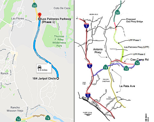 In September 2018, it was reported that the first section of the new Los Patrones Parkway opened
after the morning commute on Wednesday, Sept. 12. The road gives residents
of the growing Rancho Mission Viejo and nearby South County neighborhoods
another route for accessing the Route 241 toll road and other major
roadways out of the region. The first completed phase of the 4.5-mile
parkway connects Oso Parkway to Chiquita Canyon Drive. A later segment,
expected to open this year, will connect south to Cow Camp Road. Rancho
Mission Viejo funded the construction of the road, but it will be owned by
the county. Los Patrones Parkway is a free public road. It had been
discussed at one point as an extension of Route 241, but the county
reached an agreement with San Clemente in 2017 reiterating the road will
be free to drive. But, a project started earlier this summer to turn Oso
Parkway into a bridge over Los Patrones will make it so drivers can
connect straight to the toll road without having to encounter the stop
lights at Oso Parkway. That $30 million county project is expected to be
completed in 2020. Construction of the four-lane parkway included two
wildlife crossings that will let animals walk under the road. The
crossings are more than 200 feet long and are expected to be used by deer,
bobcats, coyotes and other animals. There are additional paths under the
road for smaller animals. The fencing was also designed with a tighter
weave at the bottom to keep out smaller animals and it’s tall enough
to bar larger animals.
In September 2018, it was reported that the first section of the new Los Patrones Parkway opened
after the morning commute on Wednesday, Sept. 12. The road gives residents
of the growing Rancho Mission Viejo and nearby South County neighborhoods
another route for accessing the Route 241 toll road and other major
roadways out of the region. The first completed phase of the 4.5-mile
parkway connects Oso Parkway to Chiquita Canyon Drive. A later segment,
expected to open this year, will connect south to Cow Camp Road. Rancho
Mission Viejo funded the construction of the road, but it will be owned by
the county. Los Patrones Parkway is a free public road. It had been
discussed at one point as an extension of Route 241, but the county
reached an agreement with San Clemente in 2017 reiterating the road will
be free to drive. But, a project started earlier this summer to turn Oso
Parkway into a bridge over Los Patrones will make it so drivers can
connect straight to the toll road without having to encounter the stop
lights at Oso Parkway. That $30 million county project is expected to be
completed in 2020. Construction of the four-lane parkway included two
wildlife crossings that will let animals walk under the road. The
crossings are more than 200 feet long and are expected to be used by deer,
bobcats, coyotes and other animals. There are additional paths under the
road for smaller animals. The fencing was also designed with a tighter
weave at the bottom to keep out smaller animals and it’s tall enough
to bar larger animals.
(Source: OC Register, 9/11/2018)
A project in the making since 2004, Los Patrones
Parkway (LPP) (formerly named “F” Street) was approved by the
Orange County Board of Supervisors as an arterial highway providing
traffic relief for future proposed development within Rancho Mission Viejo
Community Development, LLC. (RMV) and South Orange County. LPP will be a
newly built arterial highway with four lanes (two in each direction) with
connections at Oso Parkway, Chiquita Canyon Drive, and Cow Camp Road. RMV
is leading the $103 million LPP Project with regulatory oversight from
OCPW, environmental agencies, and Caltrans District 12 (for the Oso
Parkway connection). Currently, OCPW, is providing inspection services
and, together with Caltrans District 12, will provide compliance
oversight. The contractor was hired by RMV and construction is being
administered by RMV. Construction of the project began in 2015 and
completion is planned in 2018. Project grading is nearly complete. Phase
1, from Oso Parkway to Chiquita Canyon Drive, is scheduled for completion
to be open for traffic in Spring 2018. Phase 2, from Chiquita Canyon Drive
to Cow Camp Road, is planned to be completed 2018.
(Source: OC Public Works, July 2017)
In support of this project, the Transportation
Corridor Agencies (TCA) and Orange County Public Works initiated a project
to a portion of Oso Parkway with a new bridge structure to provide
motorists with a direct connection between Los Patrones Parkway and Route 241. The new bridge will improve traffic flow and enhance safety on Oso
Parkway and direct access to the 241 Toll Road will support traffic flow
in the area. Construction of the Oso Parkway Bridge began in August 2018.
The Oso Parkway Bridge Project consists of constructing an overcrossing
bridge structure for a portion of Oso Parkway to allow the connection of
Los Patrones Parkway to Route 241. The future bridge will contain six
lanes (three in each direction), sidewalks and dedicated bike lanes for
public use. Pedestrian access to Tesoro High School will be improved with
the construction of a new sidewalk on the south side of Oso Parkway. Los
Patrones Parkway will terminate at Oso Parkway via a northbound off ramp
and a southbound on ramp. The Oso Parkway Bridge project includes
constructing the roadway to connect the north end of Los Patrones Parkway
to the Route 241 Toll Road under the bridge structure. Construction began
in August 2018 and is expected to last approximately two years.
Construction work is scheduled weekdays, 7 a.m. to 5 p.m. with limited
night work. Two lanes will remain open on Oso Parkway at all times.
(Source: TCA: Oso Parkway Bridge page, 11/17/2018)
At the end of December 2018, it was reported that
one of the projects planned in Orange County was the Oso Parkway Bridge,
where a portion of Oso Parkway at Los Patrones Parkway near Las Flores is
being converted into a bridge to allow drivers to connect directly between
Route 241 and Los Patrones Parkway. Period: Completion by Fall 2020. Cost:
$30 million.
(Source: OC Register, 12/31/2018)
 In October 2019, it was reported that the southern segment of Los Patrones
Parkway opened to traffic in Rancho Mission Viejo on Thursday, Oct. 17.
The completed project extended the parkway about a mile and a half from
Chiquita Canyon Drive to Cow Camp Road. Officials completed the first
phase of the project from Oso Parkway to Chiquita Canyon Drive in
September 2018, and had expected to finish the entire length of
construction that year. But winter rains slowed the pace. With the
extension finished, the 4.5-mile, four-lane public road connects Rancho
Mission Viejo residents, especially those in the Esencia neighborhoods, to
Oso Parkway and the Route 241 toll road. OC Public Works is overseeing a
$30 million project to turn Oso Parkway into a bridge and to connect the
Route 241 toll road directly to Los Patrones Parkway. Drivers on Los
Patrones should directly connect to the Route 241 toll road by spring
2020. The entire stretch of Los Patrones Parkway cost $98 million to
construct, funding happened through a partnership between Rancho Mission
Viejo, the county and the Transportation Corridor Agencies. The road will
also be a link to Rancho Mission Viejo’s Planning Area 3. The area
is named Rienda, which is Spanish for reins, reflecting the
community’s equestrian heritage. The 2,000-acre area could be
developed with up to 7,000 homes and 2 million square feet of commercial
space. Rancho Mission Viejo will soon build a bridge to extend Cow Camp
Road into the Rienda community. Cow Camp Road would ultimately connect to
Ortega Highway, although that plan is years out. Los Patrones Parkway may
go through another extension. Officials have proposed extending the road
to Avenida La Pata as a way to address traffic in south county, instead of
extending the Route 241 toll road to San Clemente. Several options are
being studied.
In October 2019, it was reported that the southern segment of Los Patrones
Parkway opened to traffic in Rancho Mission Viejo on Thursday, Oct. 17.
The completed project extended the parkway about a mile and a half from
Chiquita Canyon Drive to Cow Camp Road. Officials completed the first
phase of the project from Oso Parkway to Chiquita Canyon Drive in
September 2018, and had expected to finish the entire length of
construction that year. But winter rains slowed the pace. With the
extension finished, the 4.5-mile, four-lane public road connects Rancho
Mission Viejo residents, especially those in the Esencia neighborhoods, to
Oso Parkway and the Route 241 toll road. OC Public Works is overseeing a
$30 million project to turn Oso Parkway into a bridge and to connect the
Route 241 toll road directly to Los Patrones Parkway. Drivers on Los
Patrones should directly connect to the Route 241 toll road by spring
2020. The entire stretch of Los Patrones Parkway cost $98 million to
construct, funding happened through a partnership between Rancho Mission
Viejo, the county and the Transportation Corridor Agencies. The road will
also be a link to Rancho Mission Viejo’s Planning Area 3. The area
is named Rienda, which is Spanish for reins, reflecting the
community’s equestrian heritage. The 2,000-acre area could be
developed with up to 7,000 homes and 2 million square feet of commercial
space. Rancho Mission Viejo will soon build a bridge to extend Cow Camp
Road into the Rienda community. Cow Camp Road would ultimately connect to
Ortega Highway, although that plan is years out. Los Patrones Parkway may
go through another extension. Officials have proposed extending the road
to Avenida La Pata as a way to address traffic in south county, instead of
extending the Route 241 toll road to San Clemente. Several options are
being studied.
(Source: OC Register, 10/18/2019)
In March 2020, TCA officials confirmed Alternative
22 would be exclusively recommended to the San Joaquin Hills (SJHTCA) and
Foothill/Eastern Transportation Corridor Agency (F/ETCA) Board of
Directors. Alternative 22, a road alignment plan that Orange County Board
Supervisor and Chairperson Lisa Bartlett has previously sponsored, would
connect the new Los Patrones Parkway from Cow Camp Road in Rancho Mission
Viejo to Avenida La Pata, running along the east side of the Prima
Deschecha Landfill. It would remain an un-tolled road. On March 12, the
TCA board advanced a report that advocated an untolled extension of Los
Patrones Parkway (Alternative 22 Untolled) for further consideration,
which would provide significant traffic relief with minimal environmental
and community impacts. Based on current traffic modeling and traffic
projections, extending Los Patrones Parkway as an untolled county major
thoroughfare accomplishes TCA’s efforts to complete the southern
extension of the Route 241 Toll Road. As planned, the Route 241 Toll Road
will transition into the untolled regional roadway network, similar to the
Route 261 Toll Road and Jamboree Road.
(Source: Dana Point Times, 3/3/2020; APNews,
3/12/2020)
In January 2021, it was reported that the OCTA had
completed a two-year project to construct the Oso Parkway Bridge. The new
bridge, costing $40 million and fully funded by the Transportation
Corridor Agencies, improves mobility and connectivity in South Orange
County, diverting traffic from congested surface streets and providing
improved access to businesses and restaurants in Rancho Mission Viejo,
Ladera Ranch, Mission Viejo, and Rancho Santa Margarita, and San Clemente.
The Oso Parkway Bridge offers six lanes of travel (three in each
direction) and provides a direct connection between Route 241 and Los
Patrones Parkway. The project also adds dedicated bike lanes, and a new
sidewalk on the south side of Oso Parkway enhances safety for students and
families accessing Tesoro High School. Previously, drivers were required
to use an off-ramp, wait at a signalized intersection, then use an on-ramp
to access the Route 241 Toll Road or Los Patrones Parkway.
(Source:$OC Register, 1/5/2021, San Juan Capistrano Patch, 1/13/2021)
In May 2021, it was reported that a conceptual
alignment of the non-tolled extension to Los Patrones Parkway has been
added to the county’s Master Plan of Arterial Highways and general
plans of the city and county. As part of the Comprehensive Transportation
Funding Program, OCTA awarded more than $1.8 million to help build the
extension. The preliminary engineering phase is expected to begin as early
as Fall 2021.
(Source: OCTA Blog, 5/20/2021)
Cow Camp Road -- Defacto Route 241 Extension
Cow Camp Road is designated on the County of Orange
Master Plan of Arterial Highways as an east-west Major and Primary
Arterial Highway. Cow Camp Road is also part of the County of
Orange-approved 2004 SCRIP plan. Upon its completion, Cow Camp Road will
begin at Antonio Parkway (north of San Juan Creek) and extend to the east,
ultimately connecting to Ortega Highway (Route 74), near Caspers
Wilderness Park. It will intersect with Los Patrones Parkway, an important
north-south arterial highway, which will connect to Oso Parkway at the
north. Upon its total completion to Ortega Highway, Cow Camp Road will be
four miles long and will provide three lanes in each direction for a total
of six lanes. In addition, Cow Camp Road will provide a parallel route to
the two-lane Ortega Highway, thereby providing commuter traffic relief and
creating an alternative route due to occasional Ortega Highway flooding,
accidents and other causes of closures.
(Source: Rancho Mission Viejo Transportation Fact Sheet, 2/2018)
Cow Camp Road Segment 1 is approximately 1.5 miles
and runs east from Antonio Parkway to the eastern border of Esencia
village (just past Los Patrones Parkway) on Rancho Mission Viejo. Segment
1 includes the construction of the Chiquita Canyon Bridge which spans
1,420 linear feet over Chiquita Creek and rises 75 feet above protected
open spaces of Chiquita Canyon. Cow Camp Road Segment 2 is divided into
multiple phases, the first two of which will be 1.5 miles in length and
run extending east from the edge of Esencia village (from Las Patrones
Parkway) to the future Planning Area 3 (PA-3) and include the construction
of the bridge that will extend about 1,400 linear feet over Gobernadora
Canyon. The remaining phases will extend Cow Camp Road easterly to Ortega
Highway and are also in engineering design. The cost of Phases 2-A and 2-B
is anticipated to be approximately $42 million with funding provided by a
grant from OCTA ($14.3 million) and the remainder in assessments collected
through Community Facilities Districts encompassing Rancho Mission Viejo
property owners. Construction of the first two phases is expected to
commence in spring 2018 in anticipation of completion in 2020.
(Source: Rancho Mission Viejo Transportation Fact Sheet, 2/2018)
La Pata Road Extension -- Defacto Route 241 Extension
Rancho Mission Viejo is also working to extend La
Pata Road. The extension of La Pata Road from Ortega Highway, south to
Avenida Vista Hermosa established an important South Orange County
parallel to the I-5 Freeway, allowing commuters to bypass the I-5 as they
travel from as far north as Rancho Santa Margarita via Antonio Parkway,
and south to La Pata and San Clemente where they can connect to the I-5
Freeway from Avenida Vista Hermosa. In addition, the construction of Los
Patrones Parkway establishes a new toll road-to-freeway network, starting
from the current terminus of the Route 241 toll road at Oso Parkway
heading south along Los Patrones Parkway, to Cow Camp Road, and then south
again along Antonio Parkway/La Pata Road to Avenida Vista Hermosa.
(Source: Rancho Mission Viejo Transportation Fact Sheet, 2/2018)
The 2020 Capital Improvement Plan for the TCA includes information on a
future widening project: The Route 241 Southbound Widening, between Santa
Margarita Parkway and Bake Parkway, proposes to add one lane in the
southbound direction for 4.8 miles, from south of the Melinda Road
Undercrossing (UC) (PM 18.3) to north of the Bake Parkway UC (PM 23.10).
Project includes the widening of the northbound and southbound Upper Oso
Reservoir and the Aliso Creek Bridges and construction of limited pavement
widening in the northbound to direction between these two bridges. This
was an addendum to the original Foothill Transportation Corridor –
North environmental document, Final Supplemental EIR No. 423, March 1990,
was completed in 2011.
(Source: 2020 Fiscal Capital Improvement Plan, 6/13/2019)
The 2020 Capital Improvement Plan for the TCA includes information on a
future widening project: The Route 241 Loma Segment Widening, from Post
Mile (PM) 27.6 to PM 33.6, proposes to widen six miles of the existing
Route 241 between Route 133 and north of Route 261 that includes the
addition of one lane in each direction. A PSR-PR and an addendum to the
Eastern Transportation
Corridor environmental document and permits were completed in 2011.
(Source: 2020 Fiscal Capital Improvement Plan, 6/13/2019)
At Hicks Haul Road (~ ORA 28.662) there is a bridge to the W of the
freeway. This bridge was part of a planned interchange with Jeffrey
Road.This interchange was part of the original planning for the Eastern
Transportation Corridor, and is included as a Future Capital Project
(post-2025) in the 2020 Planning Document. F/ETCA, There is currently a
study effort to evaluate an interchange at Jeffrey Road and Route 241 as a
potential access point to the Frank R. Bowerman Landfill from Route 241.
The extension of Jeffrey Road, north of Portola Parkway to
Route 241, is included in the County of Orange Master Plan of Arterial
Highways (MPAH). This interchange was included in the original Eastern
Transportation Corridor environmental document. If this project moves
beyond the study phase, the project will be programed for environmental
planning, design, and construction.
(Source: FB Comment by Cary Thomas Bellaflor in the Freeways of Los Angeles FB Group, 11/1/2020, 2020 Fiscal Capital Improvement Plan, 6/13/2019)
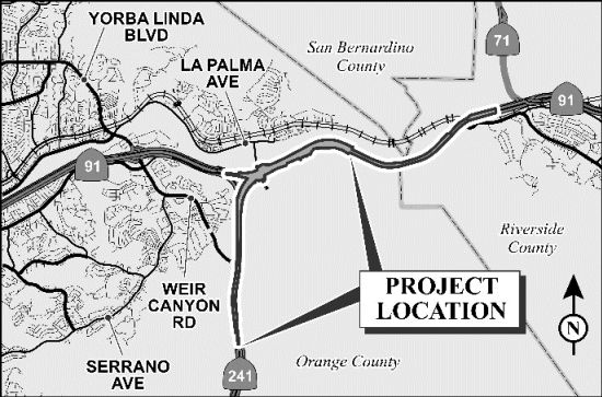
Route 241 to Route 91 Connectors 12-ORA-241 (PM 36.1/39.1)
 In November 2016, it was noted that the Transportation Corridor Agencies (TCA), in coordination
with Caltrans, is proposing to add a direct connector linking the
northbound Route 241 Toll Road to the eastbound Route 91 Express Lanes and
the westbound Route 91 Express Lanes to the southbound Route 241 Toll
Road. The direct, median-to-median tolled connector would reduce traffic
congestion in both directions, enhance safety by reducing weaving across
lanes and improve access to toll lanes in Orange and Riverside Counties.
The 60-day public comment period for the Draft Supplemental Environmental
Impact Report/Environmental Impact Statement closed on January 9, 2017.
The Project Development Team is reviewing and evaluating all comments
received. Responses to these comments will be included in the Final
Environmental Impact Statement/Record of Decision (FEIS/ROD) in
approximately December 2017. (Note that as of March 2019, there were still
no updates on this project).
In November 2016, it was noted that the Transportation Corridor Agencies (TCA), in coordination
with Caltrans, is proposing to add a direct connector linking the
northbound Route 241 Toll Road to the eastbound Route 91 Express Lanes and
the westbound Route 91 Express Lanes to the southbound Route 241 Toll
Road. The direct, median-to-median tolled connector would reduce traffic
congestion in both directions, enhance safety by reducing weaving across
lanes and improve access to toll lanes in Orange and Riverside Counties.
The 60-day public comment period for the Draft Supplemental Environmental
Impact Report/Environmental Impact Statement closed on January 9, 2017.
The Project Development Team is reviewing and evaluating all comments
received. Responses to these comments will be included in the Final
Environmental Impact Statement/Record of Decision (FEIS/ROD) in
approximately December 2017. (Note that as of March 2019, there were still
no updates on this project).
(Source: District 12 Project Page)
According to the Draft SEIR, the Proposed Project,
located at the junction of Route 241 and Route 91 in the cities of
Anaheim, Yorba Linda, and Corona, and the counties of Orange and
Riverside, would provide improved access between Route 241 and Route 91,
and is proposed to be a tolled facility. The proposed median-to-median
connector project encompasses 12-ORA-241 (PM 36.1/39.1), 12-ORA-91 (PM
14.7/18.9), and 08-RIV-91 (PM 0.0/1.5) for a total length of approximately
8.7 miles (mi). The improvements for the connector include 5.9 mi in the
cities of Anaheim and Yorba Linda and unincorporated Orange County, from
south of Windy Ridge Wildlife Undercrossing on Route 241 to Coal Canyon
Undercrossing on Route 91. The remaining 2.8 mi of the Proposed Project
include signage improvements (advance signage) in the cities of Anaheim
(1.2 mi), Yorba Linda (0.1 mi), and Corona (1.5 mi) and unincorporated
Orange and Riverside counties, with exact placement of the signage pending
the Final Design process. The Proposed Project is mostly within existing
California Department of Transportation (Caltrans) right-of-way, with one
partial acquisition required adjacent to eastbound Route 91. Construction
access and staging areas would occur within existing Caltrans right-of-way
and the partial acquisition adjacent to eastbound Route 91 as noted above.
The objectives of the Proposed Project are to implement the buildout of
the Eastern Transportation Corridor (ETC), attain compatibility with the
Route 91 mainline and 91 Express Lanes configuration, improve
operations and traffic flow between the 91 Express Lanes and the
Route 241 general purpose connectors, help achieve the Regional Mobility
Plan goals of reducing emissions from transportation sources, and enhance
the efficiency of the tolled system, thereby reducing congestion on the
non-tolled system on Route 91. The Proposed Project is needed to provide a
direct connection between Route 241 and the 91 Express Lanes to
accommodate the buildout of the ETC as well as existing and future
transportation demand. The proposed median-to-median connector is a later
phase of the ETC project, previously approved in 1994. It was originally
evaluated as a Route 241/Route 91 highoccupancy vehicle (HOV) direct
connector in the 1991 ETC Draft Environmental Impact Report/Environmental
Impact Statement (Draft EIR/EIS), 1992 ETC Final EIR, and the 1994 ETC
Final EIS (all of which studied a broader Project Area with improvements
on Route 133, Route 241, and Route 261. There was only one build
alternative and the no-build alternative.
(Source: Draft SEIR for Rte 241/Rte 91 Connectors, Project Alternatives Chapter)
The Build Alternative would construct a two-lane express lane median-to-median connector between Route 241 and Route 91, which would connect lanes from the median of northbound Route 241 to the existing eastbound median 91 Express Lanes and the reverse movement from the westbound median 91 Express Lanes to the median of southbound Route 241. The connector would be tolled. The Build Alternative would merge into the existing Orange County Transportation Authority (OCTA) 91 Express Lanes at Coal Canyon Undercrossing. The Riverside County Transportation Commission’s (RCTC) Route 91 Corridor Improvement Project (CIP) will extend the express lanes on Route 91 east to I-15. The Build Alternative is compatible with the approved Route 91 CIP for both the initial and ultimate configurations, including the number and widths of the express lanes, express auxiliary lanes, and general purpose lanes.
In December 2017, it was reported that OCTA leaders
have pushed for a delay on any plans for a $180 million ramp linking the
Route 241 toll road and Route 91 Freeway Express Lanes (~ ORA R16.184)
over fears the project could increase congestion on both the freeway and
the tollway that runs along the middle of it. The 10-3 vote by the Orange
County Transportation Authority’s board requests that the
Transportation Corridor Agencies – the public agency that runs the
Route 241 toll road and is the driving force behind the proposed connector
– slow down on plans for an elaborate ramp connecting the paid
traffic lanes. Instead, the OCTA board directed its staffers to work with
the Riverside County Transportation Commission to come up with big-picture
proposals on how to improve the chronically congested traffic lanes on
Route 91. The vote follows a recommendation earlier this month by the
OCTA’s Executive Committee. It is unclear if the project could
proceed without the backing of the OCTA, which owns the 91 Express Lanes.
Rush-hour commuters coming from south and central Orange County going to
Riverside County who are willing to pay tolls to avoid as much congestion
as possible must choose: Take Route 241 and endure the Route 91 freeway,
because drivers can’t enter the Route 91 Express Lanes at that
point. Or endure traffic before reaching the Route 91 Express Lanes. It
takes a long leg in the middle to take both. The ramp would connect the
tollways in both directions, although public debate has focused on the
eastbound direction. The Transportation Corridor Agencies touts the Route 241/Express Lanes connector as key to decreasing congestion, creating more
efficient toll lanes and improving safety for drivers who would no longer
have to weave over multiple lanes of traffic to move between Route 241 and
91 Express Lanes at the county border. That is the first place motorists
coming from Orange County can exit the Express Lanes; they can enter it
there, too. OCTA’s staffers, however, disagree. They say the
connector would lure more motorists to the overall corridor, and create
more weaving at the Orange County/Riverside County line. Orange County
Supervisor Shawn Nelson questioned why if Caltrans thought the current
freeway setup was so dangerous its officials didn’t do something
about it when Route 241 was first built.
(Source: OC Register, 12/11/2017)
In December 2017, it was reported that Orange County
Transportation Authority staffers fearful of increased congestion on the
Route 91 freeway and the adjacent 91 Express Lanes want Route 241 toll road leaders to pump the brakes on plans for a $180 million ramp
linking Route 241 and the Express Lanes. Further, an executive
committee, comprised of seven OCTA board members, backed that opposition,
preferring that the Transportation Corridor Agencies, which manages Route 241, to defer any work on the planned connector. Leaders of the Riverside
County Transportation Commission have raised similar concerns about the
elaborate ramp increasing traffic and congestion. The project would create
a clear shot from Route 241, which runs between south and north Orange
County along its eastern side, to the 91 Express Lanes that roll
along the middle of Route 91 into Riverside County, bypassing typical
freeway traffic the entire route for those willing to pay tolls. Caltrans,
which serves as owner and operator of state freeways, has approved the
draft environmental plan for the connector, said Caltrans spokeswoman
Lindsey Hart. The agency is still analyzing traffic data and public
comments about the connector to “determine the potential traffic
benefits of the project,” she added. The TCA was hoping to complete
the final design of the connector in early 2018. If approved, construction
could begin in early 2019 and take about two years to complete.
(Source: Orange County Register, 12/17/2017)
In April 2019, it was noted that concerns about
the Route 241/Route 91 transition have prompted Transportation Corridor
Agencies (TCA) officials to add increased signage, and double white lines
in an attempt to deter drivers from cutting into the NB Route 241 to EB
Route 91 transition at the last minute. But even an increased number of
law enforcement officers issuing citations doesn't seem to be deterring
drivers from illegally cutting across the double white lines. TCA is also
considering both short-term and long-term fixes to this problem. One
option includes installing pylons, also called delineators or
channelizers, between the eastbound and westbound transition lanes. A
feasibility study is currently underway, but TCA would not give a time
frame on the project. Ultimately, the decision on whether to install
channelizers up to Caltrans. Caltrans is in discussions with TCA about the
potential use of delineators, centering around various items including who
will maintain them, what benefit they will add, and if they are safe to
place at this location. They want to ensure that the delineators are set
up in a way that those who are maintaining them can do so safely, as well
as understanding the impacts that delineators can have on weaving
(merging) vehicles, the study of current traffic patterns, and what types
of traffic management actions will be needed to maintain the delineators.
As noted above, the long-term fix is the dedicated connector. Construction
could begin in 2021, with completion in 2023.
(Source: ABC 7, 4/16/2019)
In May 2019, it was reported that Caltrans received a
23-page letter from Riverside County transportation officials about all
the things they think are wrong with plans for bridges that would let toll
road drivers bypass lanes of traffic to get between the Route 241 and
Route 91 freeways. The state agency and toll road officials say
they’re taking seriously those concerns – also shared by
Orange County’s transit agency – as they decide whether to
start designing the $180 million ramps, but “as of now we are moving
forward with the project,” Caltrans spokesman David Matza said.
Riverside and Orange county officials fear solving backups on the Route 241 toll road will make things worse on the Route 91 unless the fixes
they’re planning on the Riverside Freeway are done first. They also
question traffic study data they say is too old and inconsistent. The four
agencies appear set for a turf battle: on one side are Caltrans, which
owns the state highway system, and the Transportation Corridor Agencies,
which manage Orange County’s toll roads; on the other, the Riverside
and Orange county transit agencies, which have typically taken the lead on
long-term planning and funding for new local freeway projects. Everyone
agrees building a direct path between the Route 241 toll road and Route 91
express lanes ultimately would help clear backups and improve safety. Toll
road officials want to solve congestion near the Route 241 Windy Ridge
toll plaza, where northbound cars are funneled onto the eastbound Route 91. Using the existing medians, the proposed bridges would provide a
direct route into the 91 express lanes; in the other direction,
there’s currently no way to get from the westbound Route 91 express
lanes to southbound Route 241. Orange and Riverside county transit
officials want time to do three other projects intended to loosen choke
points between I-15 and the Orange County line: building another westbound
lane on Route 91 from Green River Road to Route 241; adding ramps to move
cars from the Route 91 express lanes to the I-15; and replacing a
hairpin-turn offramp from Route 91 east to Route 71 north with a flyover
ramp that wouldn’t slow traffic as much. If TCA’s new ramps
are built and opened first, they could dump hundreds more cars into the
Route 91 express lanes at peak drive times, forcing some drivers into
already crowded general purpose lanes, Orange County Transportation
Authority spokesman Joel Zlotnik said. (Drivers would pay an additional
toll to use the new bridges.) The timeline for at least one of the
projects on Route 91 remains uncertain. The added westbound lane and I-15
connector project could be done in 2022, but officials don’t yet
have funding for construction of the Route 71 interchange. Caltrans is
nearly done with the environmental analysis, after which design can begin.
A two-year construction schedule could wrap up in 2023.
(Source: OC Register (Paywall), 5/22/2019)
In November 2019, it was reported that OCTA approved an
agreement with the Riverside County Transportation Commission,
Transportation Corridor Agencies and Caltrans that lays the groundwork for
the construction of a tolled connector between the Route 241 Toll Road and
the Route 91 Express Lanes. The agreement is a result of several months of
discussions and sets the stage for traffic relief, while ensuring the
project smoothly integrates with others planned in Orange and Riverside
counties, including the Route 91 Express Lanes/I-15 Connector and the
Route 91 Corridor Operations Project. The proposed project would connect
the Route 241 Toll Road directly with the Route 91 Express Lanes, about 2
miles west of the Orange County border with Riverside County. Construction
of the connector is anticipated to begin in 2023.
(Source: OCTA Blog, 11/6/2019)
In May 2020, the CTC approved for future consideration
of funding a project for which a Final Supplemental Environmental Impact
Report (FSEIR) has been completed: Route 241 and Route 91 in Orange and
Riverside Counties. Construct a tolled facility between Route 241 and
Route 91 in Orange and Riverside Counties. (EA 0K9700) The project is
located in the cities of Anaheim, Yorba Linda, and Corona in Orange and
Riverside counties. The project proposes to improve access and reduce
congestion at the Route 241/Route 91 interchange by providing a direct
connector between Route 241 Toll Road and the
Route 91 Express Lanes. The estimated project cost is $182,298,000.
Construction is estimated to begin Fiscal Year 2022-2023. The Department,
the Orange County Transportation Authority, the Riverside County
Transportation Commission and the Toll Roads Corridor Agency support the
project.
(Source: May 2020 CTC Agenda, Agenda Item 2.2c.(8))
According to the FSEIR, the purpose of the Proposed
Project is to implement the build out of the Eastern Transportation
Corridor (ETC), for which the Final Environmental Impact
Report/Environmental Impact Statement was approved in 1994. The overall
objective of the ETC project was to accommodate traffic growth associated
with planned and approved development in Orange County. In addition to the
originally intended objectives of the ETC, changed circumstances at the
Route 241/Route 91 interchange have led to the following objectives for
the Proposed Project: implement the built out of the ETC, as approved in
1994; attain compatibility with the Route 91 mainline and Route 91 Express
Lanes; improve traffic flow and operations by reducing weaving across
multiple general purpose lanes between the Route 91 Express Lanes and the
Route 241 general lane connectors; and enhance the efficiency of the
tolled system, thereby reducing congestion on the non-tolled system on
Route 91. The need for the Proposed Project is to address roadway
deficiencies including: peak-hour demand exceeding capacity between the
Route 241 and Route 91 connectors, lack of connectivity between
tolled/managed facilities, and weaving between general purpose connectors
and median lanes reducing traffic flow. Caltrans, in cooperation with the
Foothill/Eastern Transportation Corridor Agency (F/ETCA), proposes to
construct a tolled direct connector between Route 241 and the Route 91
Express Lanes. Currently, there is no direct connection between the Route 241 toll road and the 91 Express Lanes.
(Source: May 2020 CTC Agenda, Agenda Item 2.2c.(8))
In February 2022, it was reported that the
Transportation Corridor Agencies, which operate the Route 241 toll road,
will install about 800 “channelizers,” vertical posts made of
plastic polyurethane, that officials hope will “improve traffic flow
and promote good driving habits by preventing queue-jumpers”. The
$450,000 channelizer project is a first step toward a longer-term solution
to congestion in the area: bridges that would move cars directly between
the toll Route 241 road and the Route 91 express lanes. That $250 million
project is now being designed, with construction set to begin in 2023.
(Source: OC Register, 2/9/2022)
 Classified Landcaped Freeway
The following segments are designated as Classified Landscaped Freeway:
| County | Route | Starting PM | Ending PM |
| Orange | 241 | 24.71 | 25.20 |
| Orange | 241 | 25.25 | 26.85 |
 Commuter Lanes
There are plans for Route 241 to have HOV lanes.
 Exit Information
 Other WWW Links Status
 Portions of the route are under construction, but most of the route is now open.
There are regional transportation improvement plans to do further widening of this route between I-5 and Oso Parkway.
 Naming
 Freeway
[SHC 253.1] Entire route.
 Statistics
Overall statistics for Route 241:
 Pre-1964 Legislative Route
In 1959, Chapter 32 defined LRN 241 as “[LRN 2] near San Ysidro to [LRN 2] near the northwest boundary of the City of San Diego, easterly of existing [LRN 2]”. The urgency language noted that this was "north-south" belt-line route around the heavily populated portions of San Diego County, particularly the City of San Diego.
This is present-day I-805.
© 1996-2020 Daniel P. Faigin.
Maintained by: Daniel P. Faigin
<webmaster@cahighways.org>.
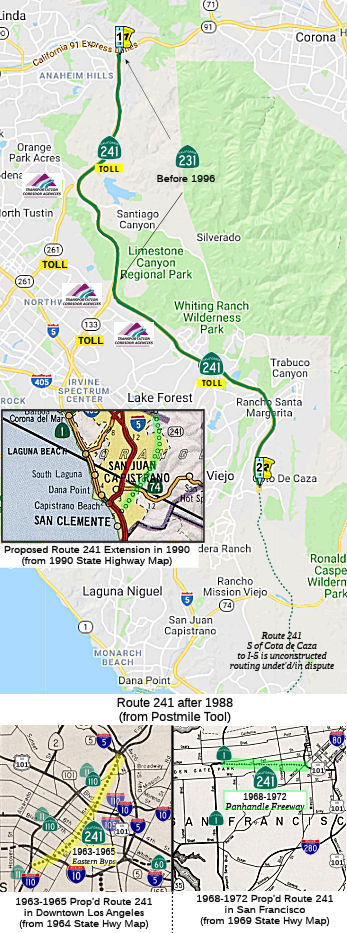
 Route 240
 Route 242