
 California Highways:
Click here for a key to the symbols used. An explanation of acronyms may be found at the bottom of the page.
 Routing
 Post 1964 Signage History
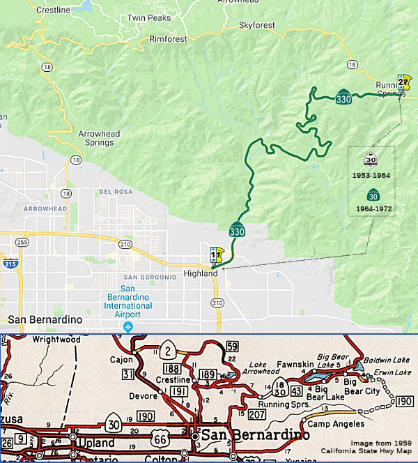
In 1964, Route 30 was defined as the route from "Route 210 near San Dimas via the vicinity of Highland northeasterly to Route 18" (at Running Springs, not Big Bear City)
A new planned freeway alignment of Route 30 and Route 106 from I-15 to
I-10 around San Bernardino appears on the 1965 Division of Highways State
Map. Route 106 was defined in 1963 as "from Route 38 near Redlands to
Route 30 near Highland", and was extended in 1965 to start at I-10. A
small proposed connector freeway for Route 30 to reach I-210 on the
Foothill Freeway appears on the 1969 Division of Highways State Map
between San Dimas east to Claremont. The planned freeway route for Route 30 from I-210 east to Route 106 appears in far greater detail on the 1970
Division of Highways State Map. Route 30 from Alta Loma east to Muscoy was
planned to be built to freeway standards directly over Highland Avenue.
(Source: Gribblenation Blog "Interstate 210 and California State Route 210 on the Foothill Freeway")
In 1972, Chapter 1216 defined Route 330 as “Route 30 near Highland northeasterly to Route 18” via a transfer from Route 30. Route 30 was redefined to be "Route 210 near San Dimas via the vicinity of Highland to Route 10 near Redlands." (thus incorporating the LRN 190 portion and former Route 106)
The start of the route was changed to Route 210 by AB 1650, Ch 724, 10/10/99.
 Pre 1964 Signage History
This was part of LRN 207, defined in 1937.It was originally part of Signed Route 30, and runs along City Creek Road.
City Creek Toll Road was constructed during 1891 for $52,000 dollars as
an access roadway by the Highland Lumber Company. San Bernardino
County purchased the City Creek Toll Road in 1903 via a provision by the
State Legislature and made it a public highway. Upon purchasing City
Creek Road, San Bernardino County widened it via use of prison
labor. By 1935, City Creek Road was a major county highway between
Highland and Running Springs.
(Source: Gribblenation Blog (Tom Fearer), "California State Route 330 and City Creek Road", June 2022)
In 1937, City Creek Road was added as LRN 207, due to the existing
roadway being inadequate to handle modern traffic. LRN 207 was
defined as "LRN 190 near Highland northeasterly to LRN 43 (Route 18); also
from a point on said LRN 43 near where it crosses Deep Creek, thence
northeasterly to and connecting Forest Service North Side Road in Green
Valley." In 1941, the Green Valley segment was removed from the
legislative definition. The route was paved and graded during the 1940s.
The modernized City Creek Road fully opened to traffic by August 19,
1951. The modernized alignment was elongated from the 1891 variant
to lessen the gradient of the climb into the San Bernardino
Mountains.
(Source: Gribblenation Blog (Tom Fearer), "California State Route 330 and City Creek Road", June 2022)
In 1953, Sign Route 30 was announced. Sign Route 30 originally started at
US 66/LRN 9, and followed LRN 190 from near La Verne east to LRN 207, and
included the entirety of LRN 207 via City Creek Road to Route 18/LRN 43 at
Running Springs. By 1957, Route 30 was multiplexing Route 18/LRN 43 east
of LRN 207 to Bear Valley Dam and running along the south shore of Big
Bear Lake. In 1958, work had commenced on an extension of Route 30
from Big Bear City over planned LRN 190 towards Barton Flats via a then
unnamed 8,400-foot-high summit in San Bernardino National Forest.
Five miles of Route 30/LRN 190 east of Barton Flats were under
construction at that time. By 1961, LRN 190 was complete between US 99/US Route 70/LRN 26 in Redlands and Route 30/LRN 43 near Big Bear Lake, and
the corridor was signed as Route 38. In 1964, LRN 207 became Route 30.
(Source: Gribblenation Blog (Tom Fearer), "California State Route 330 and City Creek Road", June 2022)
 Status
Storm Damage / Washout (SBD 35.0)
In December 2010, major storms resulted in the washout of a section of Route 330 at the Postmile 35, just about 6 miles north of Highland Avenue. Repairs were estimated to be finished in late 2011 or early 2012. Work will be divvied up into three phases across the approximately 15-mile highway. The $6 million first phase to fix several smaller washouts and prepare the roadway will allow larger equipment to reach the worst-hit area.
In March 2011, it was reported that the road was reopened for commuter traffic only. Drivers will be able to drive downbound between Live Oak Road and Highland Ave in the morning between 6am and 8am. In the afternoon and evening, they will be able to drive upbound from Highland to Live Oak between 4 and 6. Traffic will only be one direction during commute times and motorists will need to use the proper lane. CHP says that they may close the road at anytime if there’s bad weather or reckless driving that endangers the safety of the construction workers.
In June 2011, it was reported that Caltrans now is targeting the full reopening for the July 4th holiday weekend.
 Scenic Route
[SHC 263.1] Entire route.
 Classified Landcaped Freeway
The following segments are designated as Classified Landscaped Freeway:
| County | Route | Starting PM | Ending PM |
| San Bernardino | 330 | R28.70 | R29.78 |
 Naming
 Route 330 in the County of San Bernardino
is named the "Steve Faris Memorial Highway" This route was named in
memory of Battalion Chief Steve Faris of the California Department of
Forestry and Fire Protection. In 1998, Battalion Chief Faris helped
establish in the Inland Empire the Mountain Rim Fire Safe Council, which
was the first of more than 14 councils that are now active in the Counties
of San Bernardino and Riverside. He was instrumental in bringing together
the fire safe councils to form the Inland Empire Fire Safe Alliance. In
2002, Battalion Chief Faris was intimately involved in the establishment
of the Mountain Area Safety Taskforce (MAST), which brought local, state,
and federal agencies together to address the critical fire situation
presented by the bark beetle-drought tree mortality issues. The
consolidated efforts of MAST and fire safe councils contributed
significantly to the safe evacuation of more than 60,000 people during the
Old Fire of 2003. Battalion Chief Faris was a friendly, giving, and
passionate person who included everyone and found a way to work with
anyone interested in his efforts to save lives and establish defensible
space for properties in the mountains. Battalion Chief Faris died in an
automobile accident in September 2006. Named by Senate Concurrent
Resolution (SCR) 12, Resolution Chapter 72, on 7/14/2009.
Route 330 in the County of San Bernardino
is named the "Steve Faris Memorial Highway" This route was named in
memory of Battalion Chief Steve Faris of the California Department of
Forestry and Fire Protection. In 1998, Battalion Chief Faris helped
establish in the Inland Empire the Mountain Rim Fire Safe Council, which
was the first of more than 14 councils that are now active in the Counties
of San Bernardino and Riverside. He was instrumental in bringing together
the fire safe councils to form the Inland Empire Fire Safe Alliance. In
2002, Battalion Chief Faris was intimately involved in the establishment
of the Mountain Area Safety Taskforce (MAST), which brought local, state,
and federal agencies together to address the critical fire situation
presented by the bark beetle-drought tree mortality issues. The
consolidated efforts of MAST and fire safe councils contributed
significantly to the safe evacuation of more than 60,000 people during the
Old Fire of 2003. Battalion Chief Faris was a friendly, giving, and
passionate person who included everyone and found a way to work with
anyone interested in his efforts to save lives and establish defensible
space for properties in the mountains. Battalion Chief Faris died in an
automobile accident in September 2006. Named by Senate Concurrent
Resolution (SCR) 12, Resolution Chapter 72, on 7/14/2009.
(Image source: Joan Moseley's Mountain Top Echoes; KBHR Big Bear News)
 Freeway
[SHC 253.1] Entire route. Added to the Freeway and Expressway system in 1959.
 Other WWW Links
 Statistics
A stub of this route, for about 1 mile going up City Creek, is built to freeway standards.
Overall statistics for Route 330:
© 1996-2020 Daniel P. Faigin.
Maintained by: Daniel P. Faigin
<webmaster@cahighways.org>.
 From Route
  Route 305
 Route 371