
 California Highways:
Click here for a key to the symbols used. An explanation of acronyms may be found at the bottom of the page.
 Routing
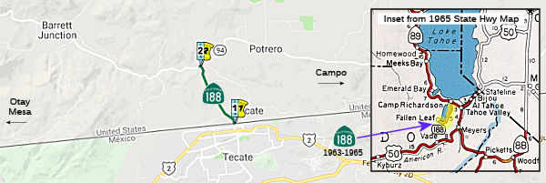 From the international boundary near Tecate to Route 94.
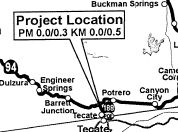
 Post 1964 Signage History
 In 1963, Route 188 was defined as "the south end of Fallen Leaf
Lake to Route 89 near Camp Richardson." This was Fallen Leaf Road near
Lake Tahoe. Few realized it was even in the state highway system. In 1965,
Chapter 1372 deleted this routing.
In 1963, Route 188 was defined as "the south end of Fallen Leaf
Lake to Route 89 near Camp Richardson." This was Fallen Leaf Road near
Lake Tahoe. Few realized it was even in the state highway system. In 1965,
Chapter 1372 deleted this routing.
At the time of deletion, Route 188 was described a 4.7-mile State Highway
which was unimproved single lane highway that was lightly traveled.
(Source: Gribblenation Blog (Tom Fearer), "Former California State Route 188 on Fallen Leaf Lake Road", May 2022)
In 1972, Chapter 1216 defined the current routing.
 Pre 1964 Signage History
The 1964-1965 routing for this route was LRN 94, defined in 1933.
LRN 94 corresponded to Fallen Leaf Lake Road, which took visitors to the
Fallen Leaf Lodge. It did not receive a sign route designation. LRN 94
appeared be in the State Highway system primarily due to the fact that
off-grid political meetings were often held during the winter at Fallen
Leaf Lake.
(Source: Gribblenation Blog (Tom Fearer), "Lake Tahoe Circle Tour Part 1", October 2018; "Former California State Route 188 on Fallen Leaf Lake Road",
May 2022)
The 1972 routing for Route 188 was not defined in 1963.
Route 188 is tied to that of the San Diego County community of
Tecate. The Californian Tecate lies directly north of the Mexican
counterpart of the same name in Baja California. A road from Potrero
to the Tecate existed by 1917, although there did not appear to be a
corresponding border crossing. The road from Potrero to Tecate appears to
follow modern day Emery Lane and Emery Road. The Tecate Port of
Entry was established around 1919. The Tecate Port of Entry
facilitated traffic to enter the United States where it followed Thing
Road towards the California Tecate. The current Tecate Port of Entry
border station was constructed during 1933. The Tecate Port of Entry
was connected to Sign Route 94 via Thing Road and Emery Road by 1935.
Modern Tecate Road was constructed to connect Sign Route 94 to Tecate Port
of Entry by 1942. Tecate Road bypassed the community of Tecate to the west
and provided a more direct route from Sign Route 94 to the Tecate Port of
Entry. In 1972, Tecate Road was added to the state highway system.
(Source: Gribblenation Blog (Tom Fearer), "California State Route 188", 8/9/2023)
Sign Route 188 was not defined as part of the initial state signage of routes in 1934. It is unclear what (if any) route was signed as Route 188 between 1934 and 1964.
 Status
In March 2005, it was reported that a remodeled and expanded port of
entry had opened. The new $18.8 million port of entry, 40 miles southeast
of San Diego, has about five times as much space as the existing facility,
which was built in 1933. The original crossing was housed in an adobe
built in the 1880s for use as a general store. Two lanes have been built
for passenger cars and two lanes for trucks. There's also a separate new
pedestrian lane. All are just to the east of the existing facility and
match its historic design. One of the biggest changes is the addition of
three secondary inspection stations, for a total of six. The complex now
occupies 13 acres, compared with 2 acres previously. A variety of
high-technology equipment is also being installed, including radiation
portal monitors, license plate readers and a gamma ray scanner. Work on
renovating the existing facility for offices, training space, conference
rooms and detention cells will begin in Spring 2005, with the goal of
finishing by the end of summer 2005. A new southbound crossing, and
expansion of northbound lanes at San Ysidro were planned as the next big
project, Construction was slated to begin in 2007 and be completed by
2012. There also are plans for a new port of entry east of the Otay Mesa
crossing, but no definite timeline has been set.
(Source: San Diego Union Tribune, 3/12/2005)
 There are plans to build truck scales near Tecate. This
project is fully funded in the 2006 State Highway Operation and Protection
Program (SHOPP). The project includes Corridor Border Infrastructure (CBI)
funds and Federal Motorcarrier funds. The total estimated project cost is
$23,870,000. The project is programmed in the 2006 SHOPP for state-only
matching funds for $8,927,000.
There are plans to build truck scales near Tecate. This
project is fully funded in the 2006 State Highway Operation and Protection
Program (SHOPP). The project includes Corridor Border Infrastructure (CBI)
funds and Federal Motorcarrier funds. The total estimated project cost is
$23,870,000. The project is programmed in the 2006 SHOPP for state-only
matching funds for $8,927,000.
 Other WWW Links
 Statistics
Overall statistics for Route 188:
 Pre-1964 Legislative Route
In 1933, Chapter 767 defined the route from "[LRN 43] near Mr. Anderson to the Cajon Pass-Lake Arrowhead Road". In 1935, this was added to the highway code with the routing:
This routing remained unchanged until the 1963 great renumbering. It ran from Route 18 near Mt. Anderson to the present-day Route 138/Route 173 junction. This is currently signed as Route 138; it was originally an extension of Sign Route 2.
© 1996-2020 Daniel P. Faigin.
Maintained by: Daniel P. Faigin
<webmaster@cahighways.org>.
 Route 187
 Route 189