
 California Highways:
Click here for a key to the symbols used. An explanation of acronyms may be found at the bottom of the page.
 Routing
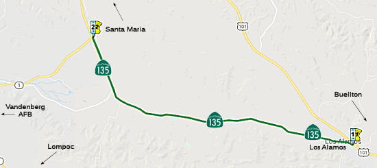 From Route 101 near Los Alamos to Route 1 south of Orcutt.
 Status
Route 101/Route 135 Separation Bridge (05-SB-101 70.6/71.2, 05-SB-135 ~0.1)
In June 2020, the CTC approved an additional $180,000
in Capital Outlay Support (COS), for the following SHOPP Bridge
Replacement project: 05-SB-101 70.7/71.2 PPNO 05-2522 ProjID 0514000003 EA
1F500 US 101 in Los Alamos, at Route 101/135 Separation No.51 -0073L/R;
also on Route 135 (PM 0.1). Outcome/Output: Replace bridges. The project
will construct a new single span bridge by bridging the median gap between
the former structures. The US 101 structure approaches, bridge rails,
metal beam guardrail, and end treatments will be replaced and sidewalk
with pedestrian railing as needed has also been added to the project along
Route 135 to improve pedestrian connectivity. The project will accommodate
planned traffic staging during construction and maintain two lanes open to
traffic in each direction on US 101. This project was programmed for
delivery in 2019-20, and the Department is requesting an allocation time
extension concurrently with this COS supplemental funds request. The
PS&E phase was allocated in August 2017 for $1,800,000, and with the
available G-12 authority, the total allotment for the PS&E phase is
$2,180,000. The Original Project Scope Study Report (PSSR) was developed
in June 2015. At the time the project was programmed, the structures work
only included replacing the superstructures and retrofitting the bent
columns. Since the original programming, it was discovered that the
project site had liquefaction potential and the project will now replace
the bridges completely instead of only replacing the superstructures.
(Source: June 2020 CTC Agenda, Agenda Item
2.5e.(1))
In August 2020, the CTC approved the following SHOPP
amendment: 05-SB-101 PM 70.7/71.2 70.6/71.2 PPNO
2522 ProjID 0514000003 EA 1F500. US 101 In Los Alamos, at from
0.3 mile south to 0.3 mile north of Route 101/135 Separation No.
51-0073L/R; also on Route 135 (PM 0.1). Replace bridges. Change Const Cap
from $14,600K to $13,590K. Note: Split landscape mitigation from this
project into EA 1F501/PPNO 05-2522Y.
(Source: August 2020 CTC Agenda, Agenda Item
2.1a.(1d) #6)
Related to the above, in August 2020, the CTC approved
the folllowing financial allocation for construction and construction
support related to the amendment: $19,614,000. 05-SB-101 PM 70.6/71.2.
PPNO 05-2522. Proj ID 0514000003 EA 1F500. US 101 In Los Alamos, from 0.3
mile south to 0.3 mile north of Route 101/Route 135 Separation No.
51-0073L/R; also on Route 135 (PM 0.1). Outcome/Output: Replace bridges to
address the deteriorated deck.
(Source: August 2020 CTC Agenda, Agenda Item
2.5b.(1) #25; Santa Ynez Star, 8/30/2020)
In January 2021, it was reported that construction
crews were set to commence work on the bridge replacement project on US 101 in Los Alamos beginning in February 2021. This project will include
intermittent full daytime and overnight closures of Route 135 for bridge
demolition and the installation of girders. These closures are
expected to take place in May, July and October of 2021 and January and
April of 2022. Motorists may exit US 101 in both directions at Cat
Canyon Road to reach Los Alamos. The contractor for this $10 million
project is Cal Portland Construction of Santa Maria, CA. The project is
set to be completed by summer of 2022.
(Source: KSBY, 1/13/2021, EdHat 1/31/2021)
In March 2022, it was reported that the project to
reconstruct the bridges on US 101 at the interchange with Route 135 in Los
Alamos continues with demolition of the southbound bridge beginning March
15, 2022. Travelers on the SB US 101 will encounter a traffic
switch onto a new bridge in the center median beginning Friday, March 11,
2022 until July 2022 while construction proceeds on new traffic lanes.
(Source: Noozhawk, 3/8/2022)
In August 2022, it was reported that the project to
reconstruct the bridges on US 101 at the interchange with Route 135 in Los
Alamos will continue with the demolition of the northbound bridge
beginning Tuesday, Sept. 6, 2022. This roadwork will result in a
24-hour closure of Route 135 between Bell/Main Street to San Antonio
Boulevard. In addition, travelers on northbound US 101 will encounter a
traffic switch onto a newly constructed bridge in the center median
beginning Aug. 31 for the next four months while construction proceeds on
new traffic lanes.
(Source: Noozhawk, 8/29/2022)
In October 2018, the CTC authorized for for future consideration of
funding the following project for which a Mitigated Negative Declaration
(MND) has been completed: Route 135 in Santa Barbara County (05-SB-135, PM
R7.2). Seismic retrofit of an existing bridge on Route 135 near the town
of Bradley. (PPNO 2567) This project is located on Route 135 at the San
Antonio Creek Bridge (No. 51-0006) in Santa Barbara County. The project
proposes to improve the service and stability of the bridge structure to
prevent collapsing during a maximum credible seismic event. It has been
determined from the Structure Replacement and Improvement Needs Report and
the Office of Earthquake Engineering Department that the bridge is
seismically deficient and has insufficient capacity to resist earthquake
loading. The proposed project is estimated to cost approximately $4.7
million. This project is fully funded and is currently programmed in the
2018 SHOPP for approximately $4.7 million. Construction is estimated to
begin in 2020. The scope, as described for the preferred alternative, is
consistent with the project scope programmed by the Commission in the 2018
SHOPP.
(Source: October 2018 CTC Agenda Item 2.2c.(1))
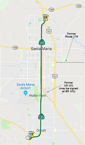 From Route 1 near Orcutt to Route 101 in Santa Maria.
StatusConstructed to freeway standards from Route 1 to north of Orcutt (~ SB R9.218 to SB 10.611).
Orcutt Gateway Veterans Flag
There has been an ongoing kerfluffle regarding
construction of a Veterans Memorial near Orcutt on Route 135 (at Clark
Ave, SB R10.437). For three years, a private citizen named Steve LeBard
has led the effort to build a privately funded memorial in Orcutt,
California—a tranquil small town located on the Golden State’s
gorgeous Central Coast—to honor military veterans. The project has
run into numerous problems. Some of these stemmed from a legal decision
regarding flag displays on Caltrans properties (an artifact of post 9/11
flag displays) that prevented display of the US Flag (since resolved), as
well as problems related to the display of military service seals and
their logos. The emotion of the effort was raised due to the usual
rhetoric. The story is this: Originally, LeBard and OTORA raised the money
for the veterans’ memorial, and in 2011 he asked CalTrans for
permission to build it by a park-and-ride near a highway on-ramp and
off-ramp, where people enter and exit when traveling to and from nearby
Vandenberg Air Force Base. Because the memorial was to be built around an
American flag, CalTrans refused to grant OTORA permission to build it.
Citing its interpretation of a decision issued by a 3-judge panel of the
Ninth Federal Circuit Court of Appeals (and the policy that CalTrans
developed in its aftermath), CalTrans declared that hanging an American
flag on public land constitutes an impermissible act of “public
expression.” As CalTrans explained to LeBard at the time, if it
allowed an American flag to be hung, “we would be placed in a
position of having to permit all forms of expression….As such, the
department has determined that the state highway system is not a forum for
public expression….” LeBard subsequently convinced Caltrans
that the flag display was permissible, but then ran into problems with the
Americans with Disabilities Act and the width of the sidewalk. He then
tried to get Caltrans to sell the land to Santa Maria, but ran into
problems with that. He last settled on a Transportation Art project, which
is when a problem with the mottos on the seals emerged.
(Source: Weekly Standard Blog 2/20/13, Project Blog 2/13/13, LA Times 3/4/13)
In November 2017, it was reported that an American flag
now flies at the entrance to Old Town Orcutt thanks to the persistence of
a Orcutt veteran. On Thursday, Nov. 30, 2017, a ceremony to raise the flag
was held at the Old Town Orcutt Flag Pole, located at the intersection of
Clark Ave. and Route 135. The event was attended by members from American
Legion Post 534, as well as several local dignitaries, including
Assemblyman Jordan Cunningham, who introduced the bill that led to the
long-awaited approval to display the flag. Cunningham authored the
legislation after learning about the long-running efforts of Steve Lebard.
Beginning in 2011, the Vietnam War veteran has been attempting to create a
veteran's memorial at the busy intersection. However, blocking the project
was a much-criticized Caltrans rule that banned the American flag at
"gateway monuments." Lebard's frustration with the rule gained national
attention, including from former FOX News anchor Bill O'Reilly and Los
Angeles Times. After spending several years going through government
red-tape, Lebard's dream picked up steam in early 2017 when Cunningham
proposed bill AB 866, which was dubbed "The Fix." "What this bill allows
for once and all, as a matter of California law, is that you can fly a
U.S. or California flag at what's called a "gateway monument, a monument
that usually marks the entrance to a city or town," Cunningham said.
(Source: KEYT, 11/30/2017)
In March 2013, the CTC vacated right of way in the city of Santa Maria along Route 135 at Santa Maria Way (~ SB 12.999), consisting of superseded highway right of way no longer needed for State highway purposes.
In August 2015, the CTC vacated right of way in the city of Santa Maria along Route 135 just north of Santa Maria Way (~ SB 12.999), consisting of superseded highway right of way no longer needed for State highway purposes.
 Post 1964 Signage History
As defined in 1963, Route 135 consisted of two segments: "(a) Route 101 near Los Alamos to Harriston. (b) Orcutt to Route 101 north of Santa Maria."
In 1968, Chapter 282 clarified the definition: "(a) Route 101 near Los Alamos to Route 1 near Harriston. (b) Route 1 near Orcutt to Route 101 north of Santa Maria."
In 1984, Chapter 1258 changed the terminus of (a) to "Route 1 south
of Orcutt near Harriston". This reflected the work
to incorporate former County Sign Route S20 was incorporated into Route 1, and the
incorporation of a portion of former Route 1 into Route 135.
In 1992, Chapter 1243 clarified the terminus of (b): "... to Route 101 north
of in Santa Maria."
Some more information on this route was provided on AAroads: The US 101
Santa Maria bypass was completed about a year or so prior to the Great
Renumbering of '64; as such, the routings were changed while LRN's were
still "the law of the land", so to speak. At that time, Route 166 from
Route 1/LRN 56 at Guadalupe east to US 101 was part of LRN 148. When the
bypass was completed around the east side of town, LRN 148 was extended
east to the bypass, signed as Route 166, which then turned north to
multiplex with US 101/LRN 2 to a point north of town, where it turned east
on Route 57 toward Maricopa. Prior to then, LRN 148 jogged on Broadway
(old US 101, now Business Route 101/Route 135) south to Stowell Road, where it turned
east. The segment from Broadway to the bypass was relinquished when LRN 148/Route 166 continued east to the new US 101 freeway. The segment of
Stowell Road east of the US 101 freeway, and the rest of former LRN 148
east to Sisquoc, became the new Route 176; it received signage in late
1968 (about the time that most formerly unsigned state-maintained highways
in Santa Barbara County, such as Route 135, Route 144, Route 217, Route 224, and Route 225 were signed in the field). The route was eventually
relinquished to the county circa 1984, with signage being removed within a
couple of years.
(Source: Scott Parker (Sparker) at AAroads, 4/7/2018)
In July 2002 and November 2002, the CTC considered rescinding the freeway adoption from PM 10.0 to PM 13.2.
 Pre 1964 Signage History
Both segments were originally part of LRN 2, which is also US 101. This indicates that they are a former routing of US 101 through Harriston and Orcutt, and were bypassed by a later version of LRN 2, which is the present-day US 101. LRN 2 was defined in 1909. These routings became branches in 1933.
According to Chris Sampang, Graciosa Road appears to be the old routing of Route 135 (pre-freeway) between south of Orcutt (where Route 135 has its north merge with Route 1) and the San Antonio Creek (2 miles south of the southern merge with Route 1). Bell Street (which is Route 135 through Los Alamos) curves back to the current US 101 expressway a mile northwest of Los Alamos, and may have been US 101 after it was rerouted off of the older Route 135 alignment (but before the bypass was built).
Route 135 was not defined as part of the initial state signage of routes in 1934. It is unclear what (if any) route was signed as Route 135 between 1934 and 1964.
 Classified Landcaped Freeway
The following segments are designated as Classified Landscaped Freeway:
| County | Route | Starting PM | Ending PM |
| Santa Barbara | 135 | R10.30 | R10.68 |
 Exit Information
 Other WWW Links
 Statistics
Overall statistics for Route 135:
 Pre-1964 Legislative Route
In 1933, Chapter 767 defined the route from "Hanford via Corcoran and Earlimart to Bakersfield-General Grant Park Road near Ducor" as a state highway. In 1935, this was added to the highway code as LRN 135, with the definition:
"[LRN 10] at Hanford via Corcoran and Earlimart to [LRN 129] near Ducor"
In 1951, Chapter 1562 rewrote the description to "[LRN 10] at
near Hanford, thence southerly in the vicinity of via
Corcoran and Earlimart to [LRN 129] near Ducor"
In 1953, Chapter 1617 changed the terminus and routing of the route to be
"[LRN 10] near Hanford, thence southerly in the vicinity of Corcoran and via
Sun
Rise City to the junction of [LRN 33] and [LRN 139] near Wasco Earlimart
to [LRN 129] near Ducor". This had the side effect of deleting
the routing on Avenue 56 to Route 65 near Ducor. That segment later became
County Sign Route J22.
In 1959, Chapter 1062 rewrote the definition again, turning the exisitng segment around and adding a second segment:
Tom Fearer put together the following explanation of the routing: The original alignment of LRN 135 from Route 65 in Ducor to Route 198 in Hanford was as follows:
In 1953, LRN 135 was realigned on a bypass around Corocan following the
modern alignment of Route 43 north to meet Route 198 at Lacey Blvd via 7th
Avenue. By 1954 the segment of LRN 135 on 56 Avenue was deleted and the
highway was routed along the modern alignment south to US 466/LRN 139 in
Wasco, which created a continuously maintained north/south highway south
to US 399. LRN 135 appears to have existed as a gap highway with a new
segment south from US 99 in Selma to the Kings County line shown in 1960.
LRN 135 was eventually extended on a bypass of Hanford to north to US 99
in Selma by 1962 via the alignment of modern Route 43. Both LRN 135 and
LRN 139 appear as part of Route 43 on the 1963 state highway map and the
alignment has largely been the same ever since.
(Source: Tom Fearer (Max Rockatansky) on AARoads, March 2017)
This routing is present-day Route 43 between the Route 43/Route 46 junction and Route 99.
© 1996-2020 Daniel P. Faigin.
Maintained by: Daniel P. Faigin
<webmaster@cahighways.org>.
 Route 134
 Route 136