
 California Highways:
Click here for a key to the symbols used. An explanation of acronyms may be found at the bottom of the page.
 Routing
 Post 1964 Signage History
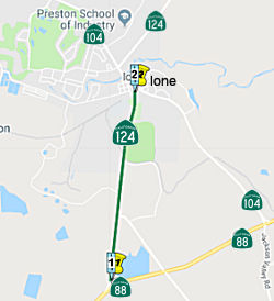
The routing of Route 124 is unchanged from 1963.
 Pre 1964 Signage History
In 1963, this was part of Route 104; however, it was not part of the original 1934 signage of Route 104. It was LRN 97, defined in 1933. Route 124 was not defined in the initial set of state signed routes in 1934.
In a thread on AARoads, Tom Feareer noted in June 2017 that Route 124 was
a post 1964 route created from parts of the original Route 104 alignment
and LRN 97. Originally it was Route 104 that ran north to Route 16 instead
of it running through downtown Ione eastward via what was an unsigned
portion of LRN 34 to Route 88. The state highway south of Ione was an
unsigned part of LRN 97, for some reason the route north out of Ione still
shows as a Route 104 but LRN 124 in 1964 but it finally shows the signage
change by 1965. Really the realignment of Route 104 made sense since the
route took a pretty wild north/south swing after being almost entirely
east/west. The 1935 Amador County Map shows LRN 97 running to Ione on Dave
Brubeck Road and maybe Marlette Street then using what became LRN 34 to
continue eastward to Jackson. That would certainly explain what the
thinking was with Route 104 in the early signed highway era. By 1940 the
state highway map shows Route 88 coming to Ione. By 1955, Route 88 is
still shown going through Ione but using part of the modern highway which
can be seen changing from 1954. In 1960, Route 88 is shown shifting
completely south of Ione in 1960.
(Source: Tom Fearer (Max R) on AARoads, "CA 124", 6/25/2017)
In the same thread, Scott Parker noted that Ione has always been
something of a mess. Originally LRN 34 east of Jackson was signed as Route 8; this continued into Alpine County and out into Nevada (along present
Route 88). Route 104 remained on LRN 34 from Ione to Route 49 just north
of Jackson, where it terminated. In 1939 it was decided to terminate Route 8 in Jackson (the longstanding multiplex on Route 49 from Mokelumne Hill
to Jackson remained intact); a new route, Route 88, was commissioned over
all of LRN 34 east of Ione and over LRN 97 southwest of there to Stockton.
Instead of terminating Route 104 at new Route 88 in Ione, it was
redirected north over the remainder of LRN 97 to terminate at Route 16
west of Route 49; this left a few blocks of state-maintained LRN 34/LRN 97
in Ione unsigned, but (apparently; I've never seen specific evidence
published) with "trailblazer"/"TO" signage from each of the separate
signed alignments. This arrangement persisted until 1959, when the "88
Connector" south of Ione was built; technically a spur of LRN 97. Signage
was simple: from EB Route 88, the LRN 97 (west) turnoff was signed "Ione"
(with an arrow on a BBS), with an attached "TO"/"Route 104" shield array;
the LRN 34 (east) turnoff was likewise signed WB only. Within Ione proper,
the intersection where Route 104 turned from east to north was signed "TO
Route 88"; once the LRN 34/LRN 97 "split" was reached in downtown Ione,
trailblazers reading "TO EAST Route 88" and "TO WEST Route 88" were
posted. The '64 renumbering cleared things up considerably. Actual signage
(Route 104, Route 124) was now posted on the connectors, with Route 104 on
the previous LRN 34 and Route 124 on LRN 97. Also at that time the
connection (now on Route 124) north to Route 16 was realigned east of its
previous track; it now intersected Route 16 only a half-mile west of that
route's eastern terminus at Route 49 near Plymouth. The new alignment was
(and is) definitely a 2-lane CA-type "expressway", with very limited side
access. Presently Ione still maintains its historic "old gold rush
village" demeanor downtown, but there's a lot of modern housing around the
town's perimeter (including a lot of second homes for Sacramento and
Stockton residents).
(Source: Scott Parker (Sparker) on AARoads, "Re: CA 124", 7/2/2017)
 Freeway
[SHC 253.1] Entire route. Added to the Freeway and Expressway system in 1959.
 Other WWW Links
 Statistics
Overall statistics for Route 124:
 Pre-1964 Legislative Route
In 1933, Chapter 767 added the route from "[LRN 4] at Chowchilla, via Robertson Boulevard to [LRN 32]" to the highway system. In 1935, this route was added to the highway code as LRN 124. It ran from US 99 near Chowchilla via Robertson Boulevard to Route 152. It is present-day Route 233.
© 1996-2020 Daniel P. Faigin.
Maintained by: Daniel P. Faigin
<webmaster@cahighways.org>.
 From Route
 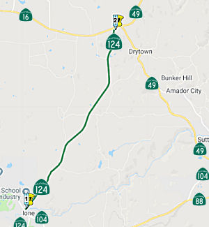 From Route
  Route 123
 Route 125