
 California Highways:
Click here for a key to the symbols used. An explanation of acronyms may be found at the bottom of the page.
 Routing
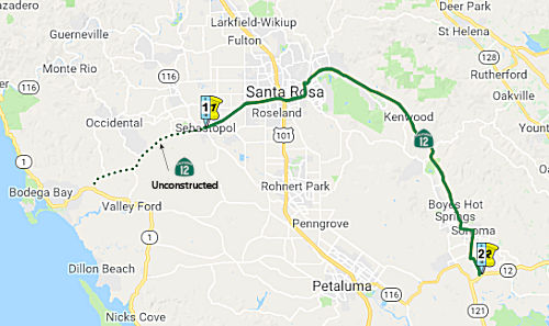 From Route 1 near Valley Ford to Route 121 near Sonoma via
Santa Rosa.
From Route 1 near Valley Ford to Route 121 near Sonoma via
Santa Rosa.
 Post 1964 Signage History
The segment was defined in 1963 by Chapter 385.
 Pre 1964 Signage History
In 1934, the original signed Route 12 was signed along the route from Jct. Route 1 near Jenner to San Andreas, via Santa Rosa, Rio Vista, and Lodi. This corresponds to what LRN 104 between Jenner and Sebastopol, and LRN 51 from Sebastopol to San Andreas. After the 1963 definition of Route 116 and the transfer of the Sebastapol to Jenner portion to Route 116 in 1964 (and the redefinition of signed Route 12 to include the extension to Route 1 near Valley Ford), Route 12 was planned for the LRN 51 extension between Sebastopol and Valley Ford.
On AARoads, Scott Parker explained why Route 116 was created: It seems
that the 1964 decision to replace Route 12 from Jenner to Sebastopol with
Route 116 was because the Bodega Bay-Sebastopol route -- part of the
Freeway & Expressway System additions -- as a LRN 51 western extension
dating from the system's original 1959 iteration -- was considered to be
the more direct and favorable route to reach the coast, as well as serving
Bodega Bay, considered to be a more popular tourist destination than
Guerneville or Jenner. The avoidance of a Route 12/Route 116 "bump" at
Sebastopol was a prime consideration as well, along with the periodic
flooding of then-LRN 104 through the Guerneville-Monte Rio area along the
lower Russian River canyon. So the renumbering took place and Route 12
signage terminated at CA 116 as it does today -- but plans were afoot to
bring the county road (Bodega Highway), which intersected Route 1 near the
small community of Bodega, into the state system in short order. But
residents in the western part of Sebastopol voiced objections to the state
assuming maintenance and signing the road because of the potential for
increased traffic through their neighborhoods, preferring (at the time) a
realignment to the south. The Division of Highways didn't demur to that
request, and Sonoma County elected to not cede the existing route to the
state. That situation, dating from around 1970, has never been resolved,
and Route 12 continues to terminate in Sebastopol as a result.
(Source: SParker on AARoads, "Re: CA 116", 1/23/2020)
From Schellville easterly to Napa, the route was cosigned as Route 12/Route 37 (now Route 12/Route 121), and was LRN 8. This is now technically part of Route 121; LRN 8 dates back to 1909.
Railroad Square in Santa Rosa refers to a neighborhood bounded by; Third
Street, Davis Street, Sixth Street and Santa Rosa Creek. The creation of
Railroad Square can be directly attributed to LRN 1 (signed as US 101
after 1926) being moved to a limited access roadway. With the passage of
the 1909 First State Highway Bond Act, LRN 1 was plotted from the Oregon
State Line to San Francisco Bay. LRN 1 headed northbound traversed Santa
Rosa using the following alignment: (1) Santa Rosa Avenue to Old
Courthouse Square; (2) Old Courthouse Square to Mendocino Avenue; (3)
Mendocino Avenue north out of Santa Rosa. During the 1919 Third State
Highway Bond Act, LRN 51 (signed as Route 12 after 1934) was added to the
Highway System. LRN 51 as originally defined was aligned between Santa
Rosa east to Shellville. The original alignment of LRN 51 east of LRN 1
branched away via 4th Street from Mendocino Avenue. In 1933, LRN 51 was
extended west through Santa Rosa to Sebastopol. LRN 51 multiplexed US 101/LRN 2 along Mendocino Avenue, Old Courthouse Square, and Santa Rosa
Avenue before splitting west along Sebastopol Road. The opening of the 4.3
mi "Santa Rosa Freeway" (in today's parlance, an expressway) route of US 101/LRN 1 on May 20th, 1949 altered the routes of US 101 and Route 12. US 101/LRN 1 moved to the Santa Rosa Freeway routing, and the route of Route 12 westbound was altered north of downtown, moving off of 4th Street
approaching downtown to meet US 101/LRN 1 via College Avenue. US 101/Route 12 multiplexed on the Santa Rosa Freeway south to Sebastopol Road where
Route 12 split west. For a time the former surface route of US 101/LRN 1
in Santa Rosa was signed as US 101A. An unintended consequence of the
Santa Rosa Freeway was that it divided what is now Railroad Square from
the rest of downtown Santa Rosa.
(Source: Gribblenation Blog "Railroad Square Historic District, US Route 101, California State Route 12; Santa Rosa, California")
Santa Rosa Freeway Routing
On January 24, 1957, the California Highway Commission (CHC) adopted a resolution declaring LRN 51 (now Route 12) to be a freeway between the city of Sebastopol through Santa Rosa to the unincorporated community of Kenwood in Sonoma County. In general the adopted freeway alignment followed the existing Route 12 alignment from the east city limits of Sebastopol to Farmers Lane. At this location a new alignment was adopted to the east following Hoen Avenue through Spring Lake Park rejoining existing Route 12 at Melita Road. It then follows the present highway routing to south of Kenwood. Following this adoption, the Department executed freeway agreements with the city of Santa Rosa on August 20, 1958 and May 5, 1959; and with Sonoma County on September 29, 1958 and July 14, 1959. The Department acquired approximately 65 parcels for construction of the adopted Route 12 east extension along Hoen Avenue from the late 1950’s to the early 1970’s. The estimated current market value as of August 2014 was between $17.5 and $25 million. In 1977 the freeway declaration on Route 12 from east of Melita Road through Kenwood continuing to Route 121 was rescinded. From Sebastopol to US 101 and from US 101 to Farmers Lane in Santa Rosa, Route 12 has been constructed as a freeway.
One correspondent noted that the freeway from Farmers
Lane to Melita Road was deleted, after one of the overpasses over Farmers
Lane was built, to provide better access from Hoen Ave. This resulted in
"To Route 12" signage for those traveling eastbound approaching Farmers
Lane.
(Source: Email from Nick Karels, 7/30/2019)
 In 1961, there was controversy regarding a proposed
freeway routing for Route 12 and Route 37 (today's Route 121) near Sonoma.
The State Highway engineer recommended the Modified P Route. This route
follows the existing highway from Sign Route 48 (now Route 37) to Sears
Point, passes W of the Schellville Airport and runs to the junction of
Sign Route 37 (now Route 121) and Route 12. That portion was not
contested. What was contested was the next portion, which runs W of Sonoma
from the site of A&B market, the N route, and the Sangiacomo Orchards
parallel to Watmaugh Rd to Arnold Dr., where it would veer N at an
interchange and run between Arnold Dr. and existing Route 12 to a point E
of Glen Ellen where it comes back to parallel the existing Route 12. There
was a large amount of opposition to this route. The freeway routing was
adopted. Later, in 1977, the CHC advertised for public comment regarding
rescinding the adoption of Route 12 and Route 121 in this area, from
Melita Road to the Sonoma/Napa County Line on Route 12, and from Sonoma to
Sears Point on Route 121. The rescinding seems to have been approved, for
as of 2023, the routing is still the original non-freeway routing through
Sonoma.
In 1961, there was controversy regarding a proposed
freeway routing for Route 12 and Route 37 (today's Route 121) near Sonoma.
The State Highway engineer recommended the Modified P Route. This route
follows the existing highway from Sign Route 48 (now Route 37) to Sears
Point, passes W of the Schellville Airport and runs to the junction of
Sign Route 37 (now Route 121) and Route 12. That portion was not
contested. What was contested was the next portion, which runs W of Sonoma
from the site of A&B market, the N route, and the Sangiacomo Orchards
parallel to Watmaugh Rd to Arnold Dr., where it would veer N at an
interchange and run between Arnold Dr. and existing Route 12 to a point E
of Glen Ellen where it comes back to parallel the existing Route 12. There
was a large amount of opposition to this route. The freeway routing was
adopted. Later, in 1977, the CHC advertised for public comment regarding
rescinding the adoption of Route 12 and Route 121 in this area, from
Melita Road to the Sonoma/Napa County Line on Route 12, and from Sonoma to
Sears Point on Route 121. The rescinding seems to have been approved, for
as of 2023, the routing is still the original non-freeway routing through
Sonoma.
(Source: Press Democrat, 9/28/1961, via Joel Windmiller, 2/1/2023;
Press Democrat, 2/3/1977 via Joel Windmiller, 2/23/2023)
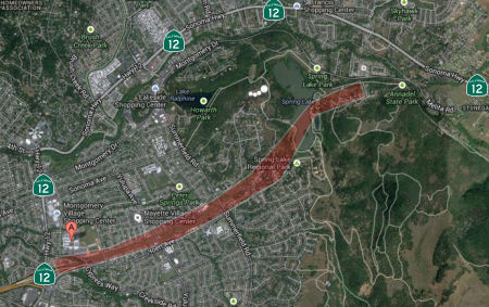 In September 2013, a report was
issued suggesting the state is willing to part with the two-mile ribbon of
land that had been designated for the extension of the freeway routing of
Route 12. The draft report on the future of the Route 12 corridor clearly
states that the State Department of Transportation has no plans to extend
the freeway east of Farmers Lane over Spring Lake and therefore doesn't
need the 50 acres long set aside for the project. The report outlines
long-range planning issues facing the stretch of highway between
Sebastopol and Sonoma. But the state's formal acknowledgment that the
project is dead is crucial because it allows CalTrans to declare the
property surplus and transfer it for other uses. The 300-foot-wide strip
of open space runs from Farmer's Lane, past Montgomery High School,
crosses Yulupa Avenue and Summerfield Road before it turns northeast and
climbs the hill to the edge of Spring Lake Regional Park.
In September 2013, a report was
issued suggesting the state is willing to part with the two-mile ribbon of
land that had been designated for the extension of the freeway routing of
Route 12. The draft report on the future of the Route 12 corridor clearly
states that the State Department of Transportation has no plans to extend
the freeway east of Farmers Lane over Spring Lake and therefore doesn't
need the 50 acres long set aside for the project. The report outlines
long-range planning issues facing the stretch of highway between
Sebastopol and Sonoma. But the state's formal acknowledgment that the
project is dead is crucial because it allows CalTrans to declare the
property surplus and transfer it for other uses. The 300-foot-wide strip
of open space runs from Farmer's Lane, past Montgomery High School,
crosses Yulupa Avenue and Summerfield Road before it turns northeast and
climbs the hill to the edge of Spring Lake Regional Park.
(Source: Press-Democrat, 9/3/2013)
In May 2014, the CTC proposed rescinding the freeway adoption near Santa Rosa. There is a lack of community support to construct a freeway on a new alignment by extending existing Route 12 through Spring Lake Park east of the city of Santa Rosa. This proposed freeway extension remains unconstructed. Consequently, the Department rescinded the freeway route adoption along the unconstructed portion of Route 12 from Farmers Lane to Melita Road. Once the route rescission is approved, the Department's responsibility is to dispose of the excess land. The unconstructed route segment is not needed for route continuity. Currently, Route 12 is a fourlane conventional highway north along Farmers Lane and then east towards Kenwood. The Department's Transportation Concept Report (TCR) for Route 12 was finalized and signed in January 2014. The 25-year corridor concept was developed by incorporating planning principles of Caltrans Smart Mobility Framework (SMF). SMF provides tools and strategies to meet the goals of Assembly Bill 32 and Senate Bill 375 on climate change and CO2 emissions reduction. The nominal 25-year facility concept for Route 12 remains a conventional highway. There is no local agency support for the proposed freeway extension of Route 12 east of Farmers lane in Santa Rosa. The proposed extension is not included as part of the Sonoma County General Plan and is no longer included as part of the city of Santa Rosa General Plan. During the public comment period, the Department received a total of 59 comments - 56 comments from the public and 3 comments from local agencies. Fifty-four comments were in support of the rescission, one was in support if certain contingencies were met, one did not specify support or opposition, and three were against it.
In July 2023, it was reported that the City Council has
taken action to clear the way for city administrators to finalize and ink
a deal with Caltrans for Santa Rosa to buy the strip of land, assembled
more than a half century ago. Originally it was meant to serve as an
extension of Route 12's freeway section over what's now Spring Lake Park
and over the ridge to north of Oakmont. Grassroots neighborhood opposition
in the late '80s and 90's stopped that. Just over $2 million dollars has
been raised for the purchase. Officials expect to have money left over,
hinting they expect a lower price, though details of the negotiations
haven't been disclosed. The city intends to buy 49-acres, with the state
transportation agency holding on to 10. As many as 244 units of affordable
housing are planned for land remaining with Caltrans. Under the terms, the
city agreed to waive requirements for the eventual developers of those
units to set aside park space, as the units will be directly adjoining the
future park. The council also approved resolutions setting the land aside
for "a public purpose" and forbidding development "in perpetuity," both
terms of the agreement. Officials say they hope to win final approval of
the deal from the California Transportation Commission in January.
(Source: Northern California Public Media, 7/28/2023)
 Status
 *Route* Unconstructed from Route 1 to Route 116. Constructed to
freeway standards for 2 miles in Santa Rosa. The traversable local routing
is Valley Ford Road and and Bodega Highway. In 2002, it was noted that 1.3
mi were widened to 40' in 1975, and the remainder is inadequate.
*Route* Unconstructed from Route 1 to Route 116. Constructed to
freeway standards for 2 miles in Santa Rosa. The traversable local routing
is Valley Ford Road and and Bodega Highway. In 2002, it was noted that 1.3
mi were widened to 40' in 1975, and the remainder is inadequate.
The 2013 Traversable Highways reports note that the segment from Route 1 to Route 116 is unconstructed. It is roughly Valley Ford Road and Bodega Highway. About 1.3 miles were widened to 40 feet in 1975. The remaining portion is not to State standards. Local project to improve Bodega Highway near Occidental is in the 2040 RTP. Completion currently anticipated for 2017.
Laguna de Santa Rosa Bridge (SON 009.63)
In September 2010, the CTC approved for future consideration of funding a project in Sonoma County that will replace the Laguna de Santa Rosa Bridge (SON 009.63) on Route 12 in the city of Sebastopol. The project is programmed in the 2010 State Highway Operation and Protection Program. Construction is estimated to begin in Fiscal Year 2010-11. Total estimated project cost is $19,213,000 for capital and support. The scope as described for the preferred alternative is consistent with the project scope programmed by the Commission in the 2010 State Highway Operation and Protection Program. The project will require construction activities in sensitive riparian habitat including wetlands. Studies concluded that the project will not have impacts to any resources in the project area.
In June 2015 Caltrans began construction on Route 12 at
the Laguna de Santa Rosa bridge. Over two construction seasons Caltrans
will replace the existing Laguna de Santa Rosa Bridge on Route 12 with a
new two-lane bridge that complies with the current Caltrans roadway
standards of 12 ft. lanes and 8 ft. shoulders. In addition, there will be
7 ft. sidewalks on both sides of the highway (on the bridge). One-half of
the bridge will be constructed in one season; traffic will be shifted to
the new bridge; demolition will take place on the old bridge; then the
final portion will be built in the second construction season. The
majority of the work will take place during the day, but residents may
notice increased noise from construction and mandatory backup alarms.
Construction is expected to be complete in 2017. The existing Laguna
Bridge is being replaced because of underwater scouring and erosion. The
220-foot bridge, which spans the Laguna de Santa Rosa, was built in 1921
and widened in 1949. The bridge replacement is a $9 million project. More
than 23,000 vehicles cross the span on an average day. The construction
season is limited to between June 15 and Oct. 15 because of environmental
regulations related to the Laguna’s sensitive wildlife habitat.
(Source: Caltrans, Press Democrat, h/t AAroads)
Route 12/Fulton Road Interchange (~ SON R12.946)
In June 2019, it was reported that Santa Rosa City
Council voted to ask county transportation officials to reroute $9.5
million in regional sales tax revenue toward rebuilding the Hearn Avenue
(~ 101 SON 18.474) crossing over US 101 in south Santa Rosa, a $28 million
project that would double the number of lanes on the bridge and include
new turn lanes, bike lanes and sidewalks. The money, which comes from a
20-year county sales tax voters approved in 2004, is currently set aside
for converting the intersection of Route 12 and Fulton Road (~ 012 SON
R12.946) into a full highway interchange — a $45 million project
that has yet to begin. The decision to move the money will be up to the
Sonoma County Transportation Authority, which is likely to consider the
matter in September. There is no guarantee SCTA would assent to Santa
Rosa’s request — the money will return to a general funding
pool and wouldn’t be a direct transfer — but Hearn is clearly
a priority for the city of Santa Rosa, and SCTA is eager to deliver
critical Measure M projects. Santa Rosa has been unable to secure full
funding for each of its three Measure M projects: the Hearn Avenue bridge,
the Fulton Road interchange, and the $47.5 million dollar extension of
Farmers Lane between Bennett Valley Road and Petaluma Hill Road along the
city’s southeastern edge. Moving the Fulton money toward Hearn
— except for $500,000 that will be used for study — reflects
the city’s desire to prioritize a bigger Hearn highway crossing
without totally abandoning the west side project. The move also preserves
several million dollars in Measure M funding for the Farmers Lane
extension. Previous efforts to secure grants for Hearn Avenue were
unsuccessful, in part because Santa Rosa didn’t put up enough local
dollars to draw down matching funds. Bolstering the city’s plans
with extra cash could improve its chances. A city spokeswoman said the
two-year construction process for Hearn Avenue could begin in January 2021
if Santa Rosa is able to secure full funding by the middle of 2020.
(Source: Press Democrat, 6/12/2019)
Sonoma Creek/Hooker Creek Bridge Scour Mitigation Project (04-Son-12, PM 25.82/33.31)
 In December 2018, the CTC approved for future consideration of funding a
project located in Sonoma County on Route SR 12 near Kenwood at the Sonoma
Creek Bridge (№ 20-0027) and at the Hooker Creek Bridge (№
20-0030) near Glen Ellen (04-Son-12, PM 25.82/33.31). The project proposes
to address the scour condition of both bridges and restore them to
serviceable conditions. The scour mitigation involves replacing both
bridges to protect their structural integrity for highway safety. The
proposed project is estimated to cost approximately $25.3 million. This
project is currently funded and programmed in the 2018 SHOPP for
approximately $15.8 million. Construction is estimated to begin in 2020.
The scope, as described for the preferred alternative, is consistent with
the project scope programmed by the Commission in the 2018 SHOPP.
In December 2018, the CTC approved for future consideration of funding a
project located in Sonoma County on Route SR 12 near Kenwood at the Sonoma
Creek Bridge (№ 20-0027) and at the Hooker Creek Bridge (№
20-0030) near Glen Ellen (04-Son-12, PM 25.82/33.31). The project proposes
to address the scour condition of both bridges and restore them to
serviceable conditions. The scour mitigation involves replacing both
bridges to protect their structural integrity for highway safety. The
proposed project is estimated to cost approximately $25.3 million. This
project is currently funded and programmed in the 2018 SHOPP for
approximately $15.8 million. Construction is estimated to begin in 2020.
The scope, as described for the preferred alternative, is consistent with
the project scope programmed by the Commission in the 2018 SHOPP.
(Source: December 2018 CTC Minutes, Agenda Item
2.2c(1); Image source: Sonoma Valley Patch, 6/29/2023)
In January 2022, the CTC approved the following SHOPP
allocation: $12,422,000. 04-Son-12 25.8/33.3. PPNO 04-0269M; ProjID
0413000080; EA 4H050. Route 12 In and near Sonoma, at Sonoma Creek Bridge
№ 20 -0027 and Hooker Creek Bridge № 20-0030. Outcome/Output:
Replace scour critical bridges to restore structural integrity. (Future
consideration of funding approved under Resolution E-18-156; December
2018.) (Concurrent Amendment under SHOPP Amendment 20H-013; January 2022.)
(Twelve month time extension for CONST and CON ENG approved under Waiver
20-31; June 2020.) (Additional seven month time extension for CONST and
CON ENG approved under Waiver 21-96; June 2021.) Allocation: CON ENG
$1,670,000; CONST $10,752,000.
(Source: January 2022 CTC Agenda, Agenda Item
2.5b.(1) #6)
In June 2023, it was reported that Caltrans was
starting demolition of the existing 46-foot-wide bridge and construction
of the new 55-foot-wide Sonoma Creek Bridge. Caltrans is replacing the
bridge because of problems associated with "scour" — a process where
fast-flowing water whirlpools around the bridge columns and footings,
eroding the creek bed that supports the bridge. The bridge was built in
1922 and widened in 1950 and 1962. Over the years, the structural
integrity of a bridge can be strained to the point where replacement is
the best solution. Construction will start in June with one-way traffic
control. After one-way traffic control is no longer needed, Caltrans will
restore two lanes on Sonoma Creek Bridge and allow the free flow of
traffic. Nighttime lane closures will continue until the remaining section
of the bridge is completed. Once two lanes of Route 12 are restored on
Sonoma Creek Bridge, Caltrans will begin the replacement of Hooker Creek
Bridge, which is also on Route 12 but near the City of Sonoma. Traffic
will be detoured through Madrone and Agua Caliente roads, with the detours
expected to last some 30 days. Local traffic will be permitted as far as
the bridge.
(Source: Sonoma Valley Patch, 6/29/2023)
In December 2023, the CTC approved for future
consideration of funding the following project for which a MND and
an Addendum have been completed: State Route 12 Bridge Scour
Mitigation Project. Route 12 in Sonoma County. Address scour on
Route 12 at the Sonoma Creek Bridge and at the Hooker Creek Bridge by
replacing both bridge structures, in Sonoma County. (04-Son-12, PM
25.82/33.31; PPNO 04-2911N and 04-0269M) The project is located on Route 12 at PM 25.82 and PM 33.31, in Sonoma County. The Department proposes to
address scour on Route 12 at the Sonoma Creek Bridge and at the Hooker
Creek Bridge by replacing both bridge structures. The project is currently
programmed in the 2018 SHOPP. The total programmed amount, which includes
Right of Way (Support and Capital), and Construction (Support and Capital)
is $21,511,000. Construction began in 2020-21. The scope, as described for
the preferred alternative, is consistent with the project scope as
programmed by the Commission in the 2018 SHOPP. A copy of the MND has been
provided to Commission staff. The Commission approved the project for
future consideration of funding on December 6, 2018, under Resolution
E-18-156. Since the approval of the MND, there have been changes to the
project and an Addendum was prepared pursuant to CEQA. These changes
include refinements to the design and construction methodologies and
additional utility work at the Sonoma Creek Bridge and the Hooker Creek
Bridge. These changes resulted in slightly larger project footprints at
both bridges, as described in the Addendum. The project changes do not
meet the criteria outlined in CEQA Guidelines Section 15162 to prepare a
Subsequent MND. The Department subsequently completed an Addendum to the
MND pursuant to CEQA. The Department has approved this project for
construction. This approval and the Addendum will satisfy the
environmental requirements for this stage of the planning process.
(Source: December 2023 CTC Agenda, Agenda Item 2.2c.(2))
In October 2023, the CTC amended the following project into the SHOPP:
04-Son-12 34.93/36.1. PPNO 04-2921L; ProjID 0423000292; EA 3Y710. Route 12
Near the city of Sonoma, from Waterman Avenue to Lomita Avenue. Construct
left-turn lane onto Verano Avenue, install audible accessible pedestrian
signals (APS), and upgrade facilities to Americans with Disabilities Act
(ADA) standards. Concurrent COS allocation under Resolution FP-23-39;
October 2023. Allocation ($ × 1,000): PA&ED $1,000; PS&E
$1,010; R/W Sup $470; Con Sup $1,230; R/W Cap $150; Const Cap $4,480;
TOTAL $8,340. Begin Const 8/17/2026.
(Source: October 2023 CTC Agenda, Agenda Item 2.1a.(1a) #46)
In May 2021, it was reported that a five-month project to resurface 4
miles of Route 12 as it passes though Sonoma, from Boyes Boulevard (~ SON
35.121) to Napa St (~ SON 36.573), was starting. Beginning in mid-May
2021, crews will begin “pot-holing” to locate underground
utilities. This will be followed by “lowering utilities”
- grinding down the existing pavement to reach and replace utility
access outlets such as manholes. After that, the entire width of the
street, curb to curb, would receive asphalt resurfacing. The resurfacing
of the highway will use asphalt with rubber components, made of recycled
vehicle tires. Such rubberized asphalt has been in use since the 1960s but
is increasingly popular for, among other reasons, its noise-reducing
qualities. A Federal Highway Administration study in Arizona found that
rubberized asphalt can reduce highway noise by up to 12 decibels.
Resurfacing project will begin at the north side of the highway in Sonoma
at the intersection of Boyes Boulevard and Vallejo Avenue, and continue
south in stages to the end of construction where Broadway crosses at the
Broadway and Napa St intersection, the Sonoma city limit. The work will
also include pedestrian safety improvements at crossings that currently
lack traffic signals. Two of those will be installed on West Napa,
one an upgrade at Third Street West (in front of the St. Francis Solano
church), and a new one just west of Seventh Street West near the public
library. Pedestrian crossing improvements will include curb ramps and
bumpy yellow mats to create an ADA-compliant sidewalk. A “pedestrian
beacon” light would be activated by someone wishing to cross, which
would include an overhead traffic signal that would turn to red in both
directions. Drivers who disregard the traffic signal would be subject to
citation. However, two pedestrian crossings on Broadway - including
one which saw a 75-year-old woman struck and badly injured in the
crosswalk in April 2021 - are not currently part of the project
plans for similar safety improvements for reasons that are unclear.
Caltrans contractor Bay City Paving and Grading does plan high-visibility
crosswalks and signage at the crossing locations, similar to that recently
installed by Sonoma County at the intersection of Sonoma Highway and
Verano Avenue.
(Source: $
Sonoma Index-Tribune, 5/17/2021)
Route 12/Verano Ave Intersection (~ SON 35.93)
In March 2023, it was reported that Caltrans and Sonoma
County Public Infrastructure were holding public information meetings at
the Springs Municipal Advisory Council regarding the intersection of Route 12 and Verano Ave (~ SON 35.93). Community members have long lamented that
the high-traffic corner is dangerous and should be equipped with more
safety features. Public officials have said it’s a challenging area
for infrastructure, as Route 12 is managed by the state while Verano
Avenue is a county road. In January 2023, a pedestrian was killed while
walking a dog through the crosswalk at the intersection. In response,
Sonoma County Public Infrastructure officials added buckets filled with
bright orange traffic flags, which pedestrians were meant to wave as they
crossed to provide better visibility for cars. Most of the flags were
stolen in the first week, and as of March 31, the buckets had been removed
as well. Two other pedestrians were struck and killed around the
Verano-Route 12 intersection in the past three years, in addition to
multiple serious but non-fatal accidents.
(Source: $Sonoma Index-Tribune, 3/31/2023)
In April 2023, the results of the public information
meeting were reported. Caltrans District 4 laid out the state
agency’s short- and long-term plans for the problematic roadways,
which will be completed in collaboration with city of Sonoma Public Works
Department and Sonoma County Public Infrastructure. The short-term fixes,
set to be implemented by the end of June, include: (1) Enhanced lighting
at the northwest and southeast quadrants of the intersection; (2) Longer
crosswalk signals to allow pedestrians more time to cross, which may
include a red light for westbound traffic on Verano, or stopping traffic
in all directions while there’s a pedestrian crossing, including
prohibiting right turns on red; and (3) Install larger speed limit signs
for better driver awareness. The longer-term changes, which could take two
years to address, are currently under review in a preliminary phase and
include: (1) A protected left turn lane for westbound Verano to eastbound
Route 12; (2) A new left turn lane for cars going west on Verano to turn
left onto Route 12; (3) Permanent enhanced lighting at northwest and
southeast quadrants of intersection; (4) Traffic cameras to provide better
analytics on the intersection; (5) Install “no right turn on
red” signs to increase pedestrian safety inside the crosswalks; (6)
Install “speed feedback signs,” which flash warnings at
drivers going too fast, on each direction of Route 12; and (7) More
accessible pedestrian signals that include an audible chirp for the
visually impaired. It was noted that increasing pedestrian walk time will
lead to more traffic and congestion in the intersection.
(Source: $Sonoma Index-Tribune, 4/13/2023)
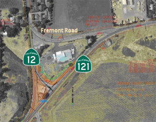 In 2012, the intersection of
Route 12 and Route 121 was reconfigured (~ SON 41.347). Prior to 2012, the
intersection had a number of angular junctions. After reconstruction, the
intersection of Route 12 and Route 121 was a traditional T-interchange,
with nearby Fremont road being turned into a westbound only spur. The
changes were prompted by an higher-than-average accident rate at the
intersection. The cost of the project is $2.4 million.
In 2012, the intersection of
Route 12 and Route 121 was reconfigured (~ SON 41.347). Prior to 2012, the
intersection had a number of angular junctions. After reconstruction, the
intersection of Route 12 and Route 121 was a traditional T-interchange,
with nearby Fremont road being turned into a westbound only spur. The
changes were prompted by an higher-than-average accident rate at the
intersection. The cost of the project is $2.4 million.
 Naming
The portion of this route constructed to freeway standards is named the "Sebastopol Freeway". This is because the freeway replaced Sebastopol Road.
Historically, this route is close to the original "El Camino Real" (The Kings Road). A portion of this route has officially been designated as part of "El Camino Real by Assembly Bill 1707, Chapter 739, on October 11, 2001.
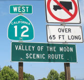 The portion of this route running through Sonoma County is called the "Valley of the Moon Scenic Route". "Valley of the
Moon" was the name Jack London, resident of Glen Ellen, coined for this
area. The first such sign with this name is when the Farmers Lane portion
ends in Santa Rosa. Another name for this portion if the Sonoma Highway.
The portion of this route running through Sonoma County is called the "Valley of the Moon Scenic Route". "Valley of the
Moon" was the name Jack London, resident of Glen Ellen, coined for this
area. The first such sign with this name is when the Farmers Lane portion
ends in Santa Rosa. Another name for this portion if the Sonoma Highway.
(Image source: Flikr)
 Route 12 from Sebastopol (~ SON 9.243) to Santa Rosa (~ SON
R15.87) is named the "Luther Burbank Memorial Highway". Luther
Burbank (1849-1926) was a famous horticulturist who developed more than
800 strains and varieties of plants, including 113 varieties of plums and
prunes, 10 varieties of berries, 50 varieties of lilies and the Freestone
peach. Born in Lancaster, Massachusetts, Burbank was brought up on a farm
and received only an elementary education. At age 21 he purchased a
17-acre tract near Lunenberg, Massachusetts, and began a 55-year plant
breeding career. In 1871 he developed the Burbank potato, which was
introduced in Ireland to help combat the blight epidemic. He sold the
rights to the Burbank potato for $150, which he used to travel to Santa
Rosa, California. In Santa Rosa, he established a nursery garden,
greenhouse, and experimental farms that have become famous throughout the
world. Burbank carried on his plant hybridization and selection on a huge
scale. At any one time he maintained as many as 3,000 experiments
involving millions of plants. In his work on plums, he tested about 30,000
new varieties. It was named by Senate Concurrent Resolution 4, Chapter 11
in 1940.
Route 12 from Sebastopol (~ SON 9.243) to Santa Rosa (~ SON
R15.87) is named the "Luther Burbank Memorial Highway". Luther
Burbank (1849-1926) was a famous horticulturist who developed more than
800 strains and varieties of plants, including 113 varieties of plums and
prunes, 10 varieties of berries, 50 varieties of lilies and the Freestone
peach. Born in Lancaster, Massachusetts, Burbank was brought up on a farm
and received only an elementary education. At age 21 he purchased a
17-acre tract near Lunenberg, Massachusetts, and began a 55-year plant
breeding career. In 1871 he developed the Burbank potato, which was
introduced in Ireland to help combat the blight epidemic. He sold the
rights to the Burbank potato for $150, which he used to travel to Santa
Rosa, California. In Santa Rosa, he established a nursery garden,
greenhouse, and experimental farms that have become famous throughout the
world. Burbank carried on his plant hybridization and selection on a huge
scale. At any one time he maintained as many as 3,000 experiments
involving millions of plants. In his work on plums, he tested about 30,000
new varieties. It was named by Senate Concurrent Resolution 4, Chapter 11
in 1940.
(Biographical information on Luther Burbank from
the National Inventors Hall of Fame; Image source: Wikipedia)
 The US 101 interchange at
Route 12 (~ SON R16.122) in the City of Santa Rosa is named the "Deputy
Frank Trejo Memorial Interchange". It was named in memory of Deputy
Frank Trejo of the Sonoma County Sheriff's Office. Deputy Trejo served the
residents of Sonoma County faithfully as a deputy sheriff for 15 years,
until March 29, 1995, when he was shot and killed in the line of duty
while investigating a suspicious motor vehicle in his beat west of the
City of Santa Rosa. Deputy Trejo was posthumously awarded the Sonoma
County Sheriff's Office highest award, the Gold Medal of Valor, for his
sacrifice. Deputy Trejo loved being a law enforcement officer, protecting
the public, and serving his community. He was a career lawman with a
career spanning 35 years, serving as a police officer for the Cities of
Lompoc and Tiburon prior to joining the Sonoma County Sheriff's Office.
Deputy Trejo was affectionately known as the "old man" in the sheriff's
office and is credited with mentoring many younger officers over the
course of his 35-year career. Named by Senate Concurrent Resolution 34,
Resolution Chapter 93, on September 15, 2011.
The US 101 interchange at
Route 12 (~ SON R16.122) in the City of Santa Rosa is named the "Deputy
Frank Trejo Memorial Interchange". It was named in memory of Deputy
Frank Trejo of the Sonoma County Sheriff's Office. Deputy Trejo served the
residents of Sonoma County faithfully as a deputy sheriff for 15 years,
until March 29, 1995, when he was shot and killed in the line of duty
while investigating a suspicious motor vehicle in his beat west of the
City of Santa Rosa. Deputy Trejo was posthumously awarded the Sonoma
County Sheriff's Office highest award, the Gold Medal of Valor, for his
sacrifice. Deputy Trejo loved being a law enforcement officer, protecting
the public, and serving his community. He was a career lawman with a
career spanning 35 years, serving as a police officer for the Cities of
Lompoc and Tiburon prior to joining the Sonoma County Sheriff's Office.
Deputy Trejo was affectionately known as the "old man" in the sheriff's
office and is credited with mentoring many younger officers over the
course of his 35-year career. Named by Senate Concurrent Resolution 34,
Resolution Chapter 93, on September 15, 2011.
(Image source: Sonoma Sheriff on FB; Officer Down Memorial Page)
South of the town of Sonoma, Route 12 is called Broadway until it intersects Route 121 near Schellville (~ SON 41.211). Route 12/Route 121 to Napa County is called alternately "Fremont Drive" or "Carneros Highway." The latter term continues into Napa County.
 Named Structures
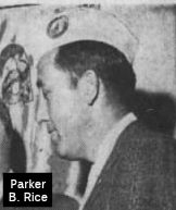 In Santa Rosa is the "Parker B. Rice Memorial Bridge" (just east of Route 101, ~ SON 16.80). It was named in
memory of Parker B. Rice, a native Californian, World War II veteran,
newspaperman, prominent leader in veteran's and service organizations, as
well as devoted husband, father, and grandfather. Following his enlistment
at the age of 18, Parker Rice served as an Army Air Corps aircraft
mechanic and saw action throughout the South Pacific, while rising to the
rank of Master Sergeant. Wounded in action during the landing of American
forces in the Philippines, he was honorably discharged in 1946; and then
embarked on a 41-year career with the Santa Rosa "Press Democrat,"
beginning as an apprentice stereotyper, and rising to production manager.
In 1951, Parker B. Rice joined the Disabled American Veterans (DAV)
Chapter 48, Santa Rosa, an affiliation that was to last 43 years, until
his death on February 15, 1995, at the age of 71. During his long tenure
with the Disabled American Veterans, Mr. Parker served as Commander of the
California Department from 1955-56, and for 15 years served on the
prestigious Claims and Service Commission, chairing the commission for 10
years. At the national level, Mr. Rice served as a member of the 16th
District National Executive Committee, and held National Junior and Senior
Vice Commander positions. Named by Assembly Concurrent Resolution 68,
Chapter 74 in 1996.
In Santa Rosa is the "Parker B. Rice Memorial Bridge" (just east of Route 101, ~ SON 16.80). It was named in
memory of Parker B. Rice, a native Californian, World War II veteran,
newspaperman, prominent leader in veteran's and service organizations, as
well as devoted husband, father, and grandfather. Following his enlistment
at the age of 18, Parker Rice served as an Army Air Corps aircraft
mechanic and saw action throughout the South Pacific, while rising to the
rank of Master Sergeant. Wounded in action during the landing of American
forces in the Philippines, he was honorably discharged in 1946; and then
embarked on a 41-year career with the Santa Rosa "Press Democrat,"
beginning as an apprentice stereotyper, and rising to production manager.
In 1951, Parker B. Rice joined the Disabled American Veterans (DAV)
Chapter 48, Santa Rosa, an affiliation that was to last 43 years, until
his death on February 15, 1995, at the age of 71. During his long tenure
with the Disabled American Veterans, Mr. Parker served as Commander of the
California Department from 1955-56, and for 15 years served on the
prestigious Claims and Service Commission, chairing the commission for 10
years. At the national level, Mr. Rice served as a member of the 16th
District National Executive Committee, and held National Junior and Senior
Vice Commander positions. Named by Assembly Concurrent Resolution 68,
Chapter 74 in 1996.
(Source: Newspapers.Com)
 Freeway
[SHC 253.2] From Route 1 near Valley Ford to Route 101 at Santa Rosa; from Route 101 near Santa Rosa to Melita Road near Santa Rosa. Note: the entire segment was defined as part of the F&E; system in 1959; in 1969, the portion from Melita Road to Route 29 was deleted from the F&E system by Chapter 726.
 Scenic Route
 Classified Landcaped Freeway
The following segments are designated as Classified Landscaped Freeway:
| County | Route | Starting PM | Ending PM |
| Sonoma | 12 | R14.89 | T17.10 |
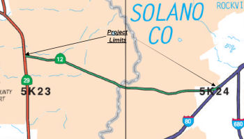
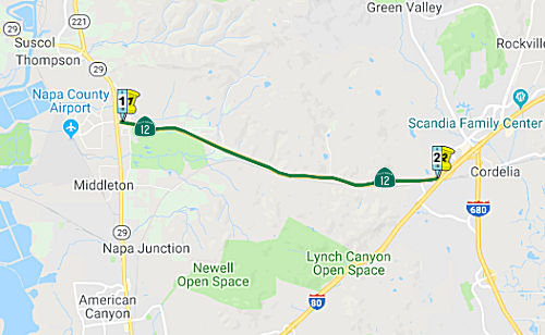 From Route 29 in the vicinity of Napa to Route 80 near Cordelia.
Post 1964 Signage HistoryThis segment is as defined in 1963 by Chapter 385.
Pre 1964 Signage HistoryCirca 1935, the first two segments of this routing were continuous.
In 1934, Route 12 was signed along the route from Jct. Route 1 near Jenner to San Andreas, via Santa Rosa, Rio Vista, and Lodi. Route 12 was dual-signed with Route 37 (now Route 121) between Sonoma and Napa, and with Route 29 from Napa for a short distance S of Napa. The portion that was cosigned with Route 29 is present-day Route 221.
 From Napa, signed Route 12 continued southerly to Cordelia in two
segments: one stretch signed as Route 12/Route 37 (now Route 12/Route 121,
and another stretch signed only as Route 12. This was also LRN 8; defined
in 1909. In 1931, this was signed as (temporary) US 40.
From Napa, signed Route 12 continued southerly to Cordelia in two
segments: one stretch signed as Route 12/Route 37 (now Route 12/Route 121,
and another stretch signed only as Route 12. This was also LRN 8; defined
in 1909. In 1931, this was signed as (temporary) US 40.
StatusSR 12/29/221 Intersection Improvements (PPNO 0376) (NAP 0.0/0.7)
The 2018 STIP, approved at the CTC March 2018 meeting, appears to change the allocation for this project from $6.3M to $12.819M (Caltrans + Napa TPA), with R/W acquisition and PS&E occuring in FY19-20. This project is at the intersection of Route 12, Route 29, and Route 221. Partial grade separation improvements
In March 2020, the CTC approved the 2020 STIP, which
increased the programmed funding for PPNO 0376 Rt 12/29/221 Soscol
intersection separation (SB1), from $9,819K to $29,819K, with the bulk
being in FY21.22.
(Source: March 2020 CTC Agenda, Item 4.7, 2020 STIP
Adopted 3/25/2020)
In June 2021, the CTC approved amending the STIP to use
the funding available through the 2021 Mid-Cycle STIP and share
distribution of the federal Coronavirus Response and Relief Supplemental
Appropriations Act of 2021 funds (COVID Relief Funds) to increase funding
for a project already in the STIP as follows: Route 12/Route 29/Route 221
Soscol Junction Intersection Separation Project (PPNO 0376); program $739K
to the CON Support phase in FY 2021-22.
(Source: June 2021 CTC Agenda, Agenda Item
2.1a.(19))
Jameson Canyon Widening (High Priority Project #1081) (~ NAP 0.086 to SOL R2.559)
 An EIR has been prepared regarding conversion of the existing two-lange highway
known as Jameson Canyon Road into a four-lane divided expressway. (January
2002 CTC Agenda 2.2a.(2)). This is actually TCRP Project #157, which will
do congestion relief improvements from Route 29 to I-80 through Jamison
Canyon. In March 2006, it was reported that environmental studies and
preliminary engineering have been delayed due to inability to hire a
consultant to complete the technical studies. The United States Fish and
Wildlife Services (USFWS) is requiring additional surveys to determine the
impacts on the Red Legged Frog and Fairy Shrimp within the project limits.
The USFWS is now requiring that the survey of the Red Legged Frog be
conducted over a two-year period, instead of the previous one-year
requirement. For the Fairy Shrimp, a one-year survey during both wet and
dry seasons must be conducted, when previously such a survey was not
required. Estimated completion is now September 2010. In 2007, the CTC
recommended using $73.99M from the Corridor Mobility Improvement Account
(CMIA) for phase 1 of the Jameson Canyon Widening. In October 2009,
recieved information the Caltrans plans to:Redistribute environmental
phase programming not attributable to the CMIA Phase 1 project to a new
Phase 2 project (PPNO 0367H).Make minor adjustments to the project post
miles of the CMIA Phase 1 project to more accurately reflect the actual
project limits. Split the CMIA Phase 1 project into two roadway contracts
and one follow-up landscape contract.The rationale is that the project
environmental document, approved in January 2008, environmentally cleared
the construction of the ultimate 4-lane conventional highway with a 3.6
meter median. This scope was found to be too large to fund and construct
at once, so plans were made to phase implementation of the overall
improvement project. Phase 1, the CMIA project, will construct two new
lanes adjacent to the existing roadway. However, Phase 1 does not include
funding to fully update all horizontal and vertical curve deficiencies of
the existing roadway. Phase 2, therefore, will upgrade the existing
facility to current standards when full funding becomes available. Since
the environmental studies were initiated prior to identification of a
phased project, and prior to selection of Phase 1 for CMIA funding, the
full programmed budget and expenditures for environmental work were
attributed to what has become Phase 1. The proposed redistribution of the
costs for environmental between Phase 1 and Phase 2 will serve to better
align budgets and expenditures attributable to each of the two projects.
The outcome is the creation of a new project to represent Phase 2 (PPNO
0367H) and a shift of $2,190,000 from Phase 1 environmental to Phase 2
environmental. The specific segments under the redivision are:Segment 1
(PPNO 0367D): On Route 12 in Napa and Solano Counties, from 0.5 mile west
of Napa/Solano County Line to Red Top Road in Solano County. Construct two
lanes, add a median barrier and a median opening. Segment 2 (PPNO 0367I):
On Route 12 in Napa County, from Route 29 junction to 0.1 mile west of
Napa/Solano Line. Construct two lanes and add a median barrier.Segment 3
(PPNO 0367J): On Route 12 in Napa and Solano Counties, from Kelly Road
(Napa) to Red Top Road (Solano). Construct replacement landscaping.
An EIR has been prepared regarding conversion of the existing two-lange highway
known as Jameson Canyon Road into a four-lane divided expressway. (January
2002 CTC Agenda 2.2a.(2)). This is actually TCRP Project #157, which will
do congestion relief improvements from Route 29 to I-80 through Jamison
Canyon. In March 2006, it was reported that environmental studies and
preliminary engineering have been delayed due to inability to hire a
consultant to complete the technical studies. The United States Fish and
Wildlife Services (USFWS) is requiring additional surveys to determine the
impacts on the Red Legged Frog and Fairy Shrimp within the project limits.
The USFWS is now requiring that the survey of the Red Legged Frog be
conducted over a two-year period, instead of the previous one-year
requirement. For the Fairy Shrimp, a one-year survey during both wet and
dry seasons must be conducted, when previously such a survey was not
required. Estimated completion is now September 2010. In 2007, the CTC
recommended using $73.99M from the Corridor Mobility Improvement Account
(CMIA) for phase 1 of the Jameson Canyon Widening. In October 2009,
recieved information the Caltrans plans to:Redistribute environmental
phase programming not attributable to the CMIA Phase 1 project to a new
Phase 2 project (PPNO 0367H).Make minor adjustments to the project post
miles of the CMIA Phase 1 project to more accurately reflect the actual
project limits. Split the CMIA Phase 1 project into two roadway contracts
and one follow-up landscape contract.The rationale is that the project
environmental document, approved in January 2008, environmentally cleared
the construction of the ultimate 4-lane conventional highway with a 3.6
meter median. This scope was found to be too large to fund and construct
at once, so plans were made to phase implementation of the overall
improvement project. Phase 1, the CMIA project, will construct two new
lanes adjacent to the existing roadway. However, Phase 1 does not include
funding to fully update all horizontal and vertical curve deficiencies of
the existing roadway. Phase 2, therefore, will upgrade the existing
facility to current standards when full funding becomes available. Since
the environmental studies were initiated prior to identification of a
phased project, and prior to selection of Phase 1 for CMIA funding, the
full programmed budget and expenditures for environmental work were
attributed to what has become Phase 1. The proposed redistribution of the
costs for environmental between Phase 1 and Phase 2 will serve to better
align budgets and expenditures attributable to each of the two projects.
The outcome is the creation of a new project to represent Phase 2 (PPNO
0367H) and a shift of $2,190,000 from Phase 1 environmental to Phase 2
environmental. The specific segments under the redivision are:Segment 1
(PPNO 0367D): On Route 12 in Napa and Solano Counties, from 0.5 mile west
of Napa/Solano County Line to Red Top Road in Solano County. Construct two
lanes, add a median barrier and a median opening. Segment 2 (PPNO 0367I):
On Route 12 in Napa County, from Route 29 junction to 0.1 mile west of
Napa/Solano Line. Construct two lanes and add a median barrier.Segment 3
(PPNO 0367J): On Route 12 in Napa and Solano Counties, from Kelly Road
(Napa) to Red Top Road (Solano). Construct replacement landscaping.
The SAFETEA-LU act, enacted in August 2005 as the reauthorization of TEA-21, provided the following expenditures on or near this route:
In January 2007, the CTC considered a request to amend the funding plan for TCRP Project #157 on Route 12: Congestion relief improvements from Route 29 to I-80 through Jamison Canyon. The goal of the project is to widen Route 12 from a 2- lane highway to a 4- lane expressway. Estimated completion is FY 2012/2013. In July 2008, the CTC approved for future consideration of funding the Route 12 Widening and Route 29/Route 12 Interchange projects. The projects are being planned in three phases. Phase 1 consists of two new 12 foot-wide lanes for eastbound traffic on Route 12 for the entire limits of the existing facility, as well as the construction of retaining walls (PPNO 0367D). Phase 1 is programmed for $139,500,000 with corridor mobility improvement account (CMIA) funds, traffic congestion relief program (TCRP) funds, federal demonstration funds, regional surface transportation program funds, regional improvement program funds, and interregional improvement program funds. Construction is estimated to begin in Fiscal Year 2009-10. Phase 2 will upgrade Route 12 to current standards and is estimated to cost $77,300,000. Phase 2 is not fully funded. Phase 3, the Route 29/Route 12 Interchange project (PPNO 0373) (PM 4.2/5.4), is also not fully funded. The project is programmed for environmental for $1,500,000 in regional improvement program funds in the 2008 State Transportation Improvement Program. The total estimated project capital cost is $73,137,000.
In January 2011, the CTC reviewed a proposal (approved in March 2011) to amend the CMIA baseline agreement and the 2010 STIP for the Segment 1 (PPNO 0367D) and Segment 2 (PPNO 0367I) of the Route 12 Jameson Canyon Widening — Phase 1 (TCRP 157) project as follows: 1. Reprogram $4,100,000 Interregional Improvement Program (IIP) funds from Construction Capital for Segment 1 to Construction Support for Segment 1 ($2,750,000) and Segment 2 ($1,350,000). 2. Update the project delivery schedule. The three segments are (1) Segment 1 (PPNO 0367D): On Route 12 in Napa and Solano Counties, from 0.5 mile west of the Napa/Solano County line to Red Top Road in Solano County. Construct two lanes and add a median barrier and a median opening; (2) Segment 2 (PPNO 0367I): On Route 12 in Napa County, from the State Route 29 junction to 0.1 mile west of the Napa/Solano County line. Construct two lanes and add a median barrier; (3) Segment 3 (PPNO 0367J): On Route 12 in Napa and Solano Counties, from Kelly Road (Napa) to Red Top Road (Solano). Construct replacement landscaping. In an effort to avoid approximately $20 million in potential utility relocation costs, the roadway alignment at selected locations was modified during the design phase. The design work has been completed for both segments. This shift in alignment, along with refinement of contract unit prices for structures items, has resulted in a reduction of approximately $8 million in the Construction Capital estimate for the Segment 1. Out of these savings, $4,100,000 is proposed to cover a shortfall in Construction Support for Segment 1 ($2,750,000) and Segment 2 ($1,350,000). The remaining savings are proposed to remain with Segment 1 at this time. This was approved in March 2011.
In August 2011, the CTC approved $130 million in funds
left over from other highway projects to Jamieson Canyon. The project had
come to a screeching halt in March 2011 when the state put off selling
highway construction bonds because of California’s budget crisis.
Caltrans is splitting the project into two contracts. Work in Napa County,
where the terrain is mostly flat, is to take 18 months and cost $46
million. The Solano section, requiring nine retaining walls, including one
almost 100 feet tall, is to take 30 months and cost nearly $90 million.
(Source: Napa Valley Register)
In December 2011, Caltrans received a number of
lower-than-expected bids for the Jamieson Canyon widening. For the
3.1-mile Napa County segment, the apparent low bidder was Synergy Project
Management of San Francisco, who bid $19.9 million or 23% below
engineers— estimates. For the 3.2-mile stretch in Solano County, the
apparent low bidder was Ghilotti Construction Inc. of San Rafael, bidding
$35.6 million—nearly $12 million or 24% less than the Caltrans
estimate. The California Transportation Commission is expected to award
contracts for Jameson Canyon widening early next year, allowing for
construction to begin in the spring 2012. The Napa County segment should
be finished by late 2013, with the Solano half completed in 2014.
(Source: Napa Valley Register)
In February 2012, the CTC adjusted the project funding.
In April 2012, it was reported that the ground-breaking for the Jamieson Canyon widening project had occurred. By 2015, the roadway will be expanded from two lanes to four and a center barrier will be installed to prevent the higher-than-average frequency of head-on collisions the roadway has seen in recent decades. The work is split into two parts. The first, on the Napa County side of the roadway, is expected to be completed by late 2013. Officials hope the Solano County work, complicated by excavation through hillsides and construction of a retaining wall, will be complete by 2015 (note that this is a year later than the December 2011 estimate).
In April 2013, it was reported that construction was
progressing well. In Jamieson Canyon, Caltrans is transforming this major
link between Solano and Napa counties from a narrow, two-lane road to a
four-lane road with wide shoulders and a median barrier. A mile-long
section of new lanes east of the Solano/Napa line should be ready for
traffic by late April 2013. Eastbound and westbound motorists will use
these two new lanes while workers start doing work on the existing two
lanes of Route 12. Meanwhile, workers continue to carve away the massive
hill just west of the truck scale lanes and I-80. They are working from
the point of the future retaining wall and moving toward the highway, with
huge amounts of earth over time just appearing to melt away. The entire
four-lane version of Route 12 could be finished by mid-2014. The section
in Napa County could be finished by then end of 2013. Additionally, cars
exiting I-80 for eastbound Route 12 leading to Suisun City will have a new
off-ramp, an elevated route that will ultimately let them pass over trucks
leaving the new scales. These new truck scales could open to trucks as
early as late June or early July 2013. Then such work as adding
landscaping and demolishing the existing eastbound truck scales will take
place. The entire project could wrap up by October 2013.
(Source: Daily Republic, 4/14/13)
In May 2013, the CTC allocated an additional $2,000,000 in State Transportation Improvement Program (STIP) funds and amend the Proposition 1B Corridor Mobility Improvement Account (CMIA) baseline agreement to update the project funding plan for Segment 2 (Napa County contract) of the Route 12 Jameson Canyon Widening – Phase 1 project in Napa and Solano Counties. As of May 2013, construction is about 50 percent complete and is expected to be finished by December 2013. However, an additional $2,000,000 is needed to complete construction. This increase is proposed to be proportionally funded with IIP and RIP (Napa and Solano County) funds. The cost increase was due to design inconsistencies (design risk due to aerial surveys vs. ground surveys), waterline conflicts (the project plans provided to the City mistakenly omitted the waterline location on the roadway cross section plans), and construction delays and work inefficiencies.
In January 2014, it was reported that work was progressing well on the Jameson Canyon project for Route 12: the Napa County side is 90 percent finished and the Solano County side is 70 percent finished. Over 2013, workers on the Solano County side have carved away a large chunk of a hill that stood in the way of the widening. They’ve put two new lanes on a terrace along what’s left of this hill, some 20 feet above the existing two lanes at the highest point and extending for about a half-mile. Some of the new lanes were scheduled to open in January 2014. It was estimated that the final project completion could be as early as August 2014.
In August 2014, it was reported that the Jameson Canyon widening project should be complete by September 5, 2014. In mid-July, crews wrapped up paving work on the new, two-lane eastbound stretch on the Solano County side of the project. Finishing touches on sculpting for the retaining walls were completed the week of July 21. Finally, the crews in early August installed a concrete median separating the eastbound and westbound lanes in that stretch.
In September 2014, it was reported that the Jameson Canyon widening project was officially completed.
In July 2015, it was reported that Jameson Canyon Road,
a stretch of Route 12 between Route 29 and I-80 once known as “Blood
Alley,” is safer in 2015 than it was in 2014, thanks to a barrier in
the median and an expansion from two lanes to four. However, the incidents
of speeding have increased. Before the improvements, the highest speed he
recorded had been about 75 mph. Today, the CHP regularly catches speeders
going into the 80s and even 90s, which could negate the new safety
efforts. The posted speed limit on the highway has always been 55 mph.
Still, despite the increased speed of many drivers, the road is safer
thanks to the extra lanes and median barrier. Most collisions on the
previous highway were the result of someone crossing into oncoming
traffic, which pretty much can’t happen anymore.
(Source: Napa Valley Register, 7/15/2015)
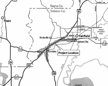
Reconstruction of the Route 12 / I-80 / I-680 Interchange Complex (High Priority Project #1812) (~ SOL R2.559)
The California Transportion Commission, in September 2000, considered a Traffic Congestion Relief Program proposal to reconstruct the I-80/I-680/Route 12 interchange; it would be a 12-interchange complex constructed in seven stages. The proposal was $1 million for stage 1; the total estimated cost was $13 million. As of December 2001, this was still on the agenda (TCRP 25.2/25.3). This is TCRP Project #25, requested by the Solano Transportation Authority.
The SAFETEA-LU act, enacted in August 2005 as the reauthorization of TEA-21, provided the following expenditures on or near this route:
In his 2006 Strategic Growth Plan, Governor Schwartzenegger proposed constructing the I-80/I-680/Route 12 Interchange Complex, including HOV Connector Lanes. He also proposed widening the route to a 4-lane expressway in Napa.
In September 2010, the CTC approved for future consideration of funding a project in Solano County that will rebuild and relocate the eastbound truck scales facility, build a four lane bridge across Suisun Creek, and construct braided ramps from the new truck scales facility to eastbound I-80 and eastbound Route 12 ramps. The project is programmed in the Trade Corridors Improvement Fund and the Traffic Congestion Relief Program and includes local funds. Construction is estimated to begin in Fiscal Year 2011-12. Total estimated project cost is $100,900,000 for capital and support. The scope as described for the preferred alternative is consistent with the project scope set forth in the proposed project baseline agreement. Resources that may be impacted by the project include; water quality, paleontology, cultural resources, visual resources hazardous waste, air quality, and noise. Potential impacts associated with the project can all be mitigated to below significance through proposed mitigation measures. Because of the sensitivity of the resources in the project area, a Final Environmental Impact Report was prepared for the project.
 In January 2013, the CTC approved for future consideration of funding a
project in Solano County that will improve the I-80/I-680/Route 12
Interchange, including the relocation of the westbound truck scales
facility on I-80. For the preferred full-build alternative, the current
total estimated cost for capital and support is $1,348,400,000. The
project is not fully funded and will be developed in phases. Only Phase
One of the full-build alternative is included in the financially
constrained Regional Transportation Plan (RTP). Within Phase One, the
first construction contract's total estimated cost for capital and support
is $100,400,000, which is funded by the 2012 State Transportation
Improvement Program (STIP), the Trade Corridor Improvement Funds (TCIF)
and local funding. The scope of the first construction contract includes
the reconstruction of the I-80/Green Valley Interchange and construction
of a two lane westbound I-80 to westbound Route 12 Connector with a new
bridge over the I-80 Green Valley Road onramp. Construction is estimated
to begin in fiscal year 2013-2014. The scope of the preferred alternative
is consistent with the scope of the first construction contract that is
programmed in the 2012 STIP and the TCIF.
In January 2013, the CTC approved for future consideration of funding a
project in Solano County that will improve the I-80/I-680/Route 12
Interchange, including the relocation of the westbound truck scales
facility on I-80. For the preferred full-build alternative, the current
total estimated cost for capital and support is $1,348,400,000. The
project is not fully funded and will be developed in phases. Only Phase
One of the full-build alternative is included in the financially
constrained Regional Transportation Plan (RTP). Within Phase One, the
first construction contract's total estimated cost for capital and support
is $100,400,000, which is funded by the 2012 State Transportation
Improvement Program (STIP), the Trade Corridor Improvement Funds (TCIF)
and local funding. The scope of the first construction contract includes
the reconstruction of the I-80/Green Valley Interchange and construction
of a two lane westbound I-80 to westbound Route 12 Connector with a new
bridge over the I-80 Green Valley Road onramp. Construction is estimated
to begin in fiscal year 2013-2014. The scope of the preferred alternative
is consistent with the scope of the first construction contract that is
programmed in the 2012 STIP and the TCIF.
In May 2013, it was reported that the funding outlook for the updated I-80/I-680/Route 12 interchange was improving. The required permit from the U.S. Army Corps of Engineers was obtained, and the Solano Transportation Authority had done what it is supposed to do to get the project ready for construction. The project is designed to improve traffic flow near the I-80 / I-680 interchange. It involves renovating the nearby Green Valley interchange and building ramps to sort traffic entering westbound I-80 from the Green Valley interchange from traffic exiting I-80 for Route 12 in Jameson Canyon. Construction work is to cost $60 million. The $24 million at risk is to come from Proposition 1B, the transportation bond passed by voters in 2006. The potential obstacle stems from the Buy America provisions, which requires that projects that receive federal dollars be built with materials made in America. Revisions in the 2012 federal transportation bill extend these provisions to contracts, including utility agreements, associated with the projects.
In August 2013, it was reported that Solano County and the state Department of Transportation are once again asking the California Transportation Commission for $24 million to help rebuild the Green Valley interchange. The $24 million has been tied up for several months because of problems stemming from new, federal Buy America provisions. Pacific Gas & Electric Co. has been unable to comply with the provisions for related utility relocations and that put the money and project at risk. The long-standing Buy America provision states that transportation projects involving federal money must use materials made in America. A 2012 addition to Buy America includes utilities doing relocation work for the projects. But PG&E officials have said that, though they want to, they cannot comply with Buy America for relocations needed for the Green Valley interchange project. A gas pipeline valve needed for the project is only manufactured outside the United States.
In April 2014, it was reported that significant
overhead work was recently completed on the I-80/I-680/Route 12
interchange project, marking a major milestone in the first phase of
construction. In particular, preliminary overhead structures were
installed earlier this month for the new Green Valley Road overcrossing
over I-80. Ground was broken for the first phase of the project in June
2014. About 75% of the work should be complete by the end of the year, a
Caltrans engineer estimated in March. The first phase should be complete
by December 2016 or a little sooner depending on the weather, he said.
(Source: Daily Republic, 4/23/2015)
In October 2015, the CTC again approved for future consideration of funding a project that will improve the I-80/I-680/Route 12 Interchange, including relocation of the westbound truck scales facility on I-80. For the preferred fullbuild alternative, the current total estimated cost for capital and support is $2,166,000,000. The project is not fully funded and will be developed in phases. Only Phase One of the full-build alternative is included in the financially constrained Regional Transportation Plan. Within Phase One, the first construction contract’s total estimated cost for capital and support is $100,400,000, which is funded by the 2012 State Transportation Improvement Program, the Trade Corridor Improvement Fund and local funding. Contract 1 of Phase One is currently under construction. The design phase of Contract 2 of Phase One is 35% complete. The scope of the first construction contract includes the reconstruction of the Interstate 80/Green Valley Interchange and construction of a two-lane westbound I-80 to westbound Route 12 Connector with a new bridge over the I-80 Green Valley Road onramp. The scope of the preferred alternative is consistent with the scope of the first construction contract that is programmed in the 2012 State Transportation Improvement Program and the Trade Corridor Improvement Fund. It was received again because an Addendum had been completed due to changes in the project since Commission approval of the Final Environmental Impacts Report (FEIR) in 2013.
The 2018 STIP, approved at the CTC March 2018 meeting, appears to have allocated $9M in FY19-20 for PS&E for PPNO 5301X I-80/I-680/Route 12 Interchange - Package 2A
In May 2018, it was reported that the California
Transportation Commission approved $53 million for a project designed to
help eliminate the Route 12/Jameson Canyon bottleneck at I-80.
Construction to create a two-lane ramp from eastbound Route 12 to
eastbound I-80 could begin in 2020, Solano Transportation Authority
Executive Director Daryl Halls said. He estimated the project will cost
about $70 million, with the remaining money coming from other sources.
Caltrans in 2014 finished widening Route 12 from two to four lanes along
the six-mile Jameson Canyon segment. But the two eastbound lanes squeeze
down to one lane at the interchange ramp, causing backups that commuters
say can top a mile.
(Source: Napa Valley Register, 5/17/2018)
In June 2020, the CTC noticed a STIP amendment to
reprogram $16,700,000 in Regional Improvement Program (RIP) funds from the
Solano I-80 Managed Lanes project (PPNO 0658L) to the Solano
I-80/I-680/Route 12 Interchange – Package 2A project (PPNO 5301X) in
Solano County. The I-80/I-680/Route 12 project will replace the existing
single-lane eastbound Route 12 to eastbound I-80 connector structure with
a new two-lane structure that meets the operational requirements for the
ultimate configuration of this interchange. The project will also
construct direct ramps to Green Valley Road that will improve safety by
eliminating the existing weaving conflicts. The construction funding
plan for the project consists of Senate Bill (SB) 1 - Trade Corridor
Enhancement Program (TCEP) and Regional Measure (RM) 2 funds, and
construction is currently programmed in Fiscal Year 2019-20. The project
is being delivered using the Construction Manager/General Contractor
(CMGC) method of delivery. However, based upon the latest cost estimate,
the construction capital cost has been revised from $50,300,000 to
$67,000,000; which is an increase of $16,700,000. This increase is due to
the following reasons: (1) Geotechnical (Earthwork and structural
section): $8 Million — After the constructability review was
conducted, an extensive redesign was needed that resulted in significant
changes in quantities and upward revisions to unit prices. These
designchanges have increased the cost of the structural section by
$6,000,000. An additional $2,000,000 increase has resulted from more
extensive soil stabilization requiring longer piles and wick drains to
consolidate the unforeseen expansive and unstable soils at the abutment
locations. (2) Drainage: $4.2 Million — Based upon the final
design, new drainage system components are needed to better drain the flat
gradients surrounding the new roadway and to avoid conflicts with the
existing drainage systems. This includes two drainage crossings under the
I-80 that require an open trench on the west end and micro-tunneling at
the east end. (3) Traffic staging: $1.0 Million — The
original design details did not fully anticipate detour complexity and
resulting traffic staging challenges which require more extensive
construction signing/striping and traffic handling measures. The revised
estimate for temporary and permanent striping and staging requirements has
resulted in a cost increase of $1.0 million. (4) Specialty items: $3.5
Million — To address the revised trash capture requirements
from the Regional Water Quality Control Board, a large bioswale will be
constructed adjacent to the Green Valley Road off-ramp. Additional erosion
control measures are also needed to stabilize the embankments and cut
sections. Finally, the cost of median barrier has gone up as a result of
revised quantities and increase in unit prices. The amendment was approved
at the August 2020 meeting.
(Source: June 2020 CTC Agenda, Agenda Item
2.1b.(1); August 2020 CTC Agenda, Agenda Item 2.1a.(3))
The STA has been working with the Metropolitan
Transportation Commission to secure Regional Measure (RM) 3 funds to cover
the cost increase. However, because of still-unresolved litigation of RM3
funds, those funds are not available at this time. Therefore, the STA is
proposing to cover this funding shortfall by re-programming $16,700,000
RIP funds from the Solano I-80 Managed Lanes project (PPNO 0658L). The
Solano I-80 Managed Lanes project is currently programmed in the 2020 STIP
with $710,000 RIP for Right of Way and $33,290,000 RIP for
Construction; all funds programmed in 2021-22. The construction phase of
this project is not fully funded at this time. The STA and the Department
are planning to seek SB 1 funds during the upcoming cycle of SB 1 funding.
The STA is committed to fully fund this project using RM3 funds once the
litigation has been resolved. There are also minor changes in the project
limits, with the new limits being 04-Sol-80 11.4/12.8.
(Source: June 2020 CTC Agenda, Agenda Item
2.1b.(1))
In August 2020, the California Transportation
Commission (CTC) approved the allocation of $69,900,000 of funds for the
second phase of the I-80/I-680/Route 12 Interchange Project. The next
phase in the seven-phase project seeks to replace the existing single-lane
eastbound Route 12 connector to eastbound I-80 with a new two-lane
connector, in addition to constructing direct on and offramps from I-80 to
Green Valley Road in Fairfield. The project was financed through funds
from Senate Bill 1’s Trade Corridor Enhancement Program, State
Transportation Improvement Program as well as regional bridge toll funds.
It is expected to begin construction in September with the overall work
estimated to last two years.
(Source: August 2020 CTC Agenda, Agenda Item
2.5s.(5); The Reporter, 8/13/2020)
In October 2020, it was reported that construction has
begun on the estimated $77 million interchange project where I-80, I-680,
and Route 12 converge in Fairfield, a two-year effort that is expected to
improve traffic flow by configuring ramps and access to local streets.
Funded largely by Senate Bill 1, the project will replace the existing
single-lane eastbound Route 12 connector to eastbound I-80, a well-known
commuter bottleneck, with a new two-lane connector on a new alignment and
bridge structure that meets design requirements for the project’s
remaining phases. Additionally, the project will include the building of a
new slip ramp from eastbound Route 12 to Green Valley Road and a new
“braided” off-ramp from eastbound I-80.
(Source: Times Herald Online, 10/29/2020)
 In May 2021, it was reported that construction was in progress on the Route 12 / I-80
connector. While Route 12 through Jameson Canyon is two lanes in each
direction, that drops to one eastbound lane just before the freeway. A
one-lane connector ramp between highway and freeway is the culprit and a
two-lane ramp is the planned solution. Construction is currently replacing
that one-lane connector ramp bridge that curves over I-80. The new bridge
is expected to open in fall 2021, and the old bridge will be demolished.
Also in the works is a component sorting out the traffic streams heading
to eastbound I-80, Green Valley Road, and southbound I-680. They presently
crisscross as drivers jockey for position. So the plan is to have the
connector ramp split after crossing the freeway, with I-80-bound traffic
going one route and Green Valley Road-bound going another. Meanwhile,
still another route will carry eastbound I-80 traffic bound for Green
Valley Road and southbound I-680. Separating these traffic streams will
mean building a second, smaller bridge.
In May 2021, it was reported that construction was in progress on the Route 12 / I-80
connector. While Route 12 through Jameson Canyon is two lanes in each
direction, that drops to one eastbound lane just before the freeway. A
one-lane connector ramp between highway and freeway is the culprit and a
two-lane ramp is the planned solution. Construction is currently replacing
that one-lane connector ramp bridge that curves over I-80. The new bridge
is expected to open in fall 2021, and the old bridge will be demolished.
Also in the works is a component sorting out the traffic streams heading
to eastbound I-80, Green Valley Road, and southbound I-680. They presently
crisscross as drivers jockey for position. So the plan is to have the
connector ramp split after crossing the freeway, with I-80-bound traffic
going one route and Green Valley Road-bound going another. Meanwhile,
still another route will carry eastbound I-80 traffic bound for Green
Valley Road and southbound I-680. Separating these traffic streams will
mean building a second, smaller bridge.
(Source: $ Napa Valley Register, 5/6/2021)
Lastly, a change is coming to Red Top Road. This
currently ends in a T-intersection at Route 12 just before the connector
ramp. Vehicles turning left or right from Red Top Road onto the highway
must squeeze amid the traffic stream. As of 5/10/2021, Caltrans will close
the Red Top Road entrance onto Route 12 for safety reasons. Motorists will
be allowed to make a right turn from eastbound Route 12 onto Red Top Road.
However, the left-turn movement from northbound Red Top Road to westbound
Route 12 toward Napa County will be eliminated. Motorists are advised to
take eastbound I-80 to the Green Valley Road exit, cross over the freeway
and take the onramp to westbound I-80/westbound Route 12 toward Napa. When
all is done, eastbound Route 12 vehicles still might not always flow onto
I-80 without a stop. If I-80 has heavy traffic, a metering light will be
triggered along the connector ramp, similar to the one that is there
today.
(Source: $ Napa Valley Register, 5/6/2021; Patch.Com, 5/6/2021)
In August 2022, it was reported that the latest piece
of the massive I-80 / I-680 / Route 12 Interchange Project was completed
Monday with the opening of the eastbound I-80 to southbound I-680
connector ramp. State Department of Transportation crews re-opened the new
connector ramp to the traveling public. Motorists traveling eastbound on
Route 12 now have direct access to the southbound I-680 connector ramp,
including drivers who are traveling eastbound on I-80, Caltrans reported.
(Source: Solano Daily Republic, 8/3/2022)
In October 2022, it was reported that officials have
marked the completion of the latest portion of a massive project to revamp
the convergence in Fairfield of I-80, I-680 and Route 12: Completion of
the connector from EB Route 12 to EB I-80. The I-80/I-680/Route 12 project
is a multiple-year, multiple-phase effort near Fairfield’s Green
Valley and Cordelia Villages neighborhoods that includes Package 1 through
Package 7. Package 1 was completed in 2017 with a new Green Valley Road
Interchange and westbound Route 12 connector from westbound I-80 to
westbound Route 12 The just-completed phase of the project, known as
Package 2A, will improve the flow of traffic through the reconfiguration
of three freeway ramps at the interchange. It replaces the existing
single-lane eastbound Route 12 to eastbound I-80 connector with a new
two-lane connector and bridge structure, constructs a new off-ramp from
eastbound Route 12 to Green Valley Road, and creates a new off-ramp from
eastbound I-80 to Green Valley Road and southbound I-680.
(Source: Solano Daily Republic, 10/22/2022)
In July 2023, it was reported that in June 2023 MTC
last month formally approved the first allocations of Regional Measure 3
dollars, releasing over $270 million for nine projects for which the
sponsors already were moving ahead under Letters of No Prejudice. These
initial allocations included: Solano Transportation Authority: $70.4
million for work on the I-80 Express Lanes project between Cordelia and
Vacaville; $1.9 million to advance Phase II of the I-80/ I-680/Route 12
interchange reconfiguration; and $30.7 million for replacement and
relocation of the westbound I-80 truck scales.
(Source: MTG/ABAG Bay Link Blog, 7/12/2023)
In May 2012, it was reported that Caltrans has started the $20.5 million Route 12 Operational Improvements Project, which will create a “Smart Corridor” using Intelligent Transportation System elements in Solano, Sacramento and San Joaquin Counties on Route 12, and on I-5 in San Joaquin County. These elements include: Changeable Message Signs, Highway Advisory Radio, Extinguishable Message Signs, Closed Circuit Televisions and Traffic Monitoring Stations. The project will improve operations by realigning Tower Park Way; add and extend existing turn lanes and acceleration lanes at various intersections between I-5 and Tower Park Way; and expand the existing Park and Ride at Thornton Road. The contractor for this project is De Silva Gates Construction and is currently in construction.
Freeway[SHC 253.2] Entire portion. Defined as part of the F&E system in 1959.
 National Trails
 According to an article in April 2017, the portion of Route 12 through Jameson Canyon near I-80 was part of the "Lincoln Highway".
The somewhat tangled tale of how Napa County belatedly secured a section
of the Lincoln Highway has its roots a century ago with a bespectacled man
in Indiana named Carl Fisher. Fisher owned the Prest-O-Lite headlight
company and helped establish the Indianapolis Motor Speedway. In 1912, he
and other auto enthusiasts plotted a transcontinental route from New
York’s Times Square to San Francisco’s Lincoln Park. This
original, Napa-less coast-to-coast route for the most part stitched
together existing roads. A 1916 Lincoln Highway guidebook said motorists
should be able to make an enjoyable cross-country trip in 20 to 30 days,
as long as rain didn’t bog them down on the unpaved sections. The
westernmost section of the original Lincoln Highway went from Sacramento
to San Francisco by way of Stockton and the Altamont Pass to avoid water
barriers (i.e., former US 50). But in 1916, the completion of the Yolo
Causeway west of Sacramento removed one of those barriers. Napans began
hoping a more direct route might pass through the city of Napa, where
tourists would stop and spend money. By 1923, efforts to create an
alternate Lincoln Highway route focused on Vallejo, taking the city of
Napa out of the picture. That alternative route became a reality after the
Carquinez Bridge was completed in 1927 to take motorists over the
Carquinez Strait. This alternative Lincoln Highway segment extends west
from Sacramento using the same route as long-gone US 40. It goes through
Davis, Vacaville and Fairfield, and then through Jameson Canyon on
today’s Route 12, where it enters south Napa County. Until a few
years ago, most of this Jameson Canyon section was two lanes and narrow
and still had the ambiance of the old Lincoln Highway. Safety and traffic
congestion concerns led to the road being widened to a four lanes in 2014.
From Jameson Canyon, the Lincoln Highway heads south along what is now
Route 29 past the county industrial center and city of American Canyon.
Then, at American Canyon Road, it swings up to Broadway Street and heads
past today’s Veterans Memorial Park to enter Vallejo and Solano
County. Some in the Lincoln Highway Associate dispute that the alternate
Lincoln Highway route through Yolo, Solano and Napa counties is
legitimate. But Kinst said Gail Hoag, an official with the Lincoln Highway
Association, in 1928 authorized Boy Scouts to erect markers along it. Napa
County’s moment of Lincoln Highway sun soon faded, for all practical
purposes. The state in 1933 began building a new US 40 route that went
through the hills between Fairfield and Vallejo, creating a much more
direct route than the local Lincoln Highway. That route became
today’s I-80.
According to an article in April 2017, the portion of Route 12 through Jameson Canyon near I-80 was part of the "Lincoln Highway".
The somewhat tangled tale of how Napa County belatedly secured a section
of the Lincoln Highway has its roots a century ago with a bespectacled man
in Indiana named Carl Fisher. Fisher owned the Prest-O-Lite headlight
company and helped establish the Indianapolis Motor Speedway. In 1912, he
and other auto enthusiasts plotted a transcontinental route from New
York’s Times Square to San Francisco’s Lincoln Park. This
original, Napa-less coast-to-coast route for the most part stitched
together existing roads. A 1916 Lincoln Highway guidebook said motorists
should be able to make an enjoyable cross-country trip in 20 to 30 days,
as long as rain didn’t bog them down on the unpaved sections. The
westernmost section of the original Lincoln Highway went from Sacramento
to San Francisco by way of Stockton and the Altamont Pass to avoid water
barriers (i.e., former US 50). But in 1916, the completion of the Yolo
Causeway west of Sacramento removed one of those barriers. Napans began
hoping a more direct route might pass through the city of Napa, where
tourists would stop and spend money. By 1923, efforts to create an
alternate Lincoln Highway route focused on Vallejo, taking the city of
Napa out of the picture. That alternative route became a reality after the
Carquinez Bridge was completed in 1927 to take motorists over the
Carquinez Strait. This alternative Lincoln Highway segment extends west
from Sacramento using the same route as long-gone US 40. It goes through
Davis, Vacaville and Fairfield, and then through Jameson Canyon on
today’s Route 12, where it enters south Napa County. Until a few
years ago, most of this Jameson Canyon section was two lanes and narrow
and still had the ambiance of the old Lincoln Highway. Safety and traffic
congestion concerns led to the road being widened to a four lanes in 2014.
From Jameson Canyon, the Lincoln Highway heads south along what is now
Route 29 past the county industrial center and city of American Canyon.
Then, at American Canyon Road, it swings up to Broadway Street and heads
past today’s Veterans Memorial Park to enter Vallejo and Solano
County. Some in the Lincoln Highway Associate dispute that the alternate
Lincoln Highway route through Yolo, Solano and Napa counties is
legitimate. But Kinst said Gail Hoag, an official with the Lincoln Highway
Association, in 1928 authorized Boy Scouts to erect markers along it. Napa
County’s moment of Lincoln Highway sun soon faded, for all practical
purposes. The state in 1933 began building a new US 40 route that went
through the hills between Fairfield and Vallejo, creating a much more
direct route than the local Lincoln Highway. That route became
today’s I-80.
(Source: Napa Valley Register, 4/1/2017)
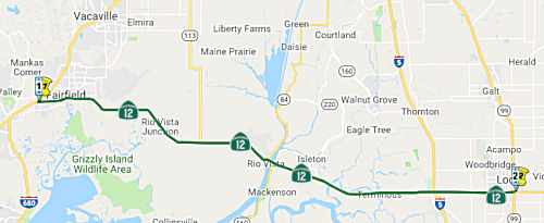 From Route 80 near Fairfield to Route 99 near Lodi via Rio Vista.
Post 1964 Signage HistoryIn 1963, this segment was defined by Chapter 385 to be "(c) Route 80 near Fairfield to Route 84 at Rio Vista. (d) Route 84 near Rio Vista to Route 99 near Lodi."
In 1976, Chapter 1384 made sections (c) and (d) contiguous, and the definition read "Route 80 near Fairfield to Route 99 near Lodi via Rio Vista." The portion from Route 84 at Rio Vista to Route 84 [Former Route 160] near Rio Vista was transferred from Route 84.
Pre 1964 Signage HistoryIn 1934, Route 12 was signed along the route from Jct. Route 1 near Jenner to San Andreas, via Santa Rosa, Rio Vista, and Lodi. This segment was LRN 53. The portion between I-80 near Fairfield and Rio Vista was defined in 1919; the remainder (Rio Vista to Route 99 near Lodi) was defined in 1921.
 At some point, this may have been a county route
-- a photo at CalTrafficSigns.com clearly shows a (temporary) County Highway 12. It could also have been an error by the Auto Club of Northern
California. This picture was supposedly taken at the intersection of Route 12 and Route 24 (now Route 160) near Rio Vista.
At some point, this may have been a county route
-- a photo at CalTrafficSigns.com clearly shows a (temporary) County Highway 12. It could also have been an error by the Auto Club of Northern
California. This picture was supposedly taken at the intersection of Route 12 and Route 24 (now Route 160) near Rio Vista.
The original (1934) alignment of Route 12 (LRN 53) east of Rio Vista took
a far different path than Route 12 does today. The original alignment of
LRN 53 from the Sacramento River and Sacramento County Line eastward to
Lodi was as follows:
(Source: Gribblenation Blog on Rte 12, 11/19/2018)
By 1940 a new proposed alignment of Route 12/LRN 53 can be seen on the
State Highway Map. The new alignment of Route 12/LRN 53 carried the route
east out of Isleton on:
(Source: Gribblenation Blog on Rte 12, 11/19/2018)
The new Route 12 bypass route south of Isleton first appears on the 1959 State Highway Map.
The Rio Vista Bridge is a vertical lift span which was gradually built
upon the site of an earlier bascule bridge between 1943 and 1960. The Rio
Vista Bridge is 2,890 in length and has a 135 foot clearance when it's
vertical span is raised. The Rio Vista Bridge is infamous for long delays
due to freight shipping traffic on the Sacramento River and averages about
20,000 vehicles a day. Various studies have been conducted to research a
replacement span but none have had much viability or much public support.
(Source: Gribblenation Blog (Tom Fearer), "California Ferry Routes; CA 84 over the Real McCoy II Ferry and CA 220 over the J-Mack Ferry")
StatusDuring the period from 1997 to 2007, the collision and fatality rate on Route 12 has increased from 60% to over 100% of the statewide average for similar routes. Since 2001, there have been 802 collisions, 494 injuries, and 21 fatalities on Route 12, including three fatal accidents in 2006 and already three fatal accidents in 2007. The California Highway Patrol has prioritized Route 12 as one of its top requests for safety corridor project funding for 2007-08. Caltrans is in the process of constructing 12.7 miles of horizontal and vertical curve corrections, shoulder widening, median and shoulder rumble strips, and pavement rehabilitation along Route 12. In addition, the Solano Transportation Authority, in partnership with the Department of Transportation, is evaluating the long-term need for a concrete median barrier along that route.
Route 12 Transportation Study (~ SOL L2.005 to SOL 026.24)
In October 2001, a study was published of this section of Route 12 between I-80 and Rio Vista. The goal of the study was to identify the physical improvements and management practices necessary to appropriately serve future travel demand in the study corridor. The study corridor includes the potion of Route 12 between I-80 and the Rio Vista Bridge. Route 12 is an important east-west route connecting Sonoma, Napa, Solano, Sacramento, San Joaquin and Calaveras Counties. A two to four-lane roadway in the study area, Route 12 contains a mixture of freeway, two-lane highway, expressway and arterial sections. There were six packages of recommendations ranging from No Build (Package 1), Transportation Demand Management (Package 2), Safety Improvements (Package 3), Near-Term Traffic Improvements (Package 4), Passing Lane Installation (Package 5), and Long-Term Improvements (Package 6). The Alternatives Evaluation identified that Alternative Package 1, the No-Build Alternative, would not adequately serve near or long-term traffic levels in the study corridor, nor would the package remedy the existing identified accident problems. Alternative Package 2, the Transportation Demand Management Alternative, was also not found to adequately serve near or long-term traffic levels forecast to prevail on Route 12 from I-80 to the Sacramento River. While Alternative Package 3, Safety Improvements, would not provide the necessary additional capacity in the study corridor, it would eliminate the existing accident problems identified by the study. The implementation of Alternative Package 4, Near-Term Traffic Improvements, would result in adequate operating conditions in the study corridor to the year 2010; however, post-2010, additional capacity enhancements are expected to be required. Alternative Package 5, Passing Lane Installation, was not found to adequately serve near or long term traffic conditions in the study corridor. Finally, only Alternative Package 6, Long-Term Traffic Improvements would result in adequate operating conditions under year 2025 traffic volumes. In the near term, Transportation Demand Management (Package 2), Safety Improvements (Package 3), and Near-Term Traffic Improvements (Package 4) were recommended. These packages included:
In the long term, the study recommended adding the following to the above packages:
I-80 near Fairfield to Rio Vista
Fairfield Roundabout (04-Sol-12, PM 19.2)
In May 2017, the CTC approved for future consideration of funding a project in Solano County that proposes to improve safety for vehicles at the intersection of Route 12 and Route 113 (04-Sol-12, PM 19.2) by installing a single lane roundabout, light poles and advance warning signs. This project is programmed into the 2016 SHOPP for $7,122,000 in Construction (capital and support) and Right of Way (capital and support). Construction is estimated to begin in 2018. The scope, as described for the preferred alternative, is consistent with the project scope programmed by the Commission in the 2016 State Highway Operation and Protection Program.
In May 2018, it was reported that Caltrans expects to
hire a contractor to construct a roundabout at Route 12 and Route 113 in
September 2018, with work starting as early as December. The estimated
cost for the entire project is $7.1 million, of which $4.67 million is
construction costs, Caltrans reports. It is funded through the State
Highway Operation and Protection Program.
(Source: Solano Daily Republic, May 2018)
In August 2018, the CTC approved approved an allocation of $7,398,000 for the SHOPP Roadside Safety Improvement project (PPNO 8060A) on Route 12 and Route 113 in Solano County. This is a safety project which will reduce the number and severity of collisions at the existing highspeed and high-truck traffic intersection of Route 12 and Route 113 near the city of Rio Vista in Solano County. Route 12 is a major east-west corridor between I-80 and I-5, and intersects with Route 113/Birds Landing Road, forming a four-legged intersection controlled by two-way stop signs. The project is within an environmentally sensitive area, with creek crossings on both Route 12 and Route 113, requiring an Incidental Take Permit (ITP) for the California Tiger Salamander (CTS) from the California Department of Fish and Wildlife (CDFW).
The California Department of Fish and Wildlife issued the Incidental Take Permit (ITP) for the project in June 2018 with the condition of a security deposit as funding assurance to ensure successful completion of mitigation and any follow-up compliance activities. The mitigation also includes 10 years of “off-site” habitat management, monitoring and reporting on the status of compensatory habitat. Caltrans is legally precluded from transferring funds “in trust” to another entity as security. On August 10, 2018, after extensive negotiations with the California Department of Fish and Wildlife, it was agreed that the ITP’s security deposit condition would be satisfied by a separate mitigation “child” project to be split from this “parent” project at the time of allocation.
Both Route 12 and Route 113 belong to the Terminal Access Network, under the Surface Transportation Act of 1982, which is a highway network that accommodates trucks longer than California standard legal length. Route 12 is also a major Department of Defense truck route that serves as a key corridor for shipments in and out of Travis Air Force Base. Route 12 has an 11 percent truck volume and an Annual Average Daily Traffic (AADT) of 15,000 vehicles, which current traffic data indicates is significantly greater than the statewide average accident rate.
This project features a single-lane roundabout with an approach to splitter islands, center truck apron, aesthetically treated center island, and advance flashing beacons. The Department conducted the Intersection Control Evaluation (ICE) and determined the single-lane roundabout alternative to be more effective operationally than the signalized intersection design. An independent consultant was hired by the Department to further review the design to ensure the safety of the high-speed traffic of the roundabout. The consultant’s recommendation was to modify the design to a larger roundabout utilizing additional safety measures.
The needed construction capital cost increase is due to
modifying the initial standard roundabout to a larger roundabout footprint
within the existing right-of-way, as recommended by the consultant, and
the additional safety traffic design measures associated with the larger
roundabout. The needed construction support cost increase is due to the
additional working days needed to accommodate construction staging and to
address environmental permit requirements.
(Source: August 2018 CTC Agenda Item 2.5d.(1))
In October 2018, the CTC amended the following project
into the 2018 SHOPP: 04-Sol-12 19.2/19.4. PPNO 8060B. Project 0419000066.
EA 4G561. Route 12 Near Rio Vista, at the intersection of Route 12 and
Route 113; also on Route 113 from PM 0.0/0.2. Environmental mitigation for
safety project EA 4G560. Note: Split off environmental mitigation work to
provide funding assurance to California Department of Fish and Wildlife
(CDFW) for EA 4G560/PPNO 04-8060A.
(Source: October 2018 CTC Agenda Item 2.1a.(1) Item
11)
In April 2019, it was reported that construction of the roundabout at Route 12 and Route 113, between Suisun City and Rio Vista, would begin at the end of April 2019.
In September 2019, it was reported that there are
increased concerns about the new roundabout under construction at Route 12
and Route 113, between Suisun City and Rio Vista. The concerns relates to
crashes during construction, specifically a recent crash where, according
to Solano CHP, an 80-year-old man driving a silver Toyota Prius was
traveling westbound on Route 12 at an undetermined speed Wednesday, when
he collided head-on with the raised concrete portion of the new
roundabout, killing him and his 79-year-old female passenger. The worry is
that the speeds on the highway (55 mph) would lead to more accidents.
According to Caltrans, roundabouts on highways do make sense and are a
proven way to cut down on traffic collisions. Caltrans statistics show
that “roundabouts reduce the number of crashes by 37% and injury
crashes by 75%”. Additionally the shape of the roundabout also
results in lower speeds, generally 15-20 mph less. This does mean that the
roundabout will likely cause a bit of a traffic backup during peak commute
times but slower moving traffic means it's doing its job. Despite the
statistics, locals also think the roundabout was made too narrow for the
big rigs and farm equipment that travel the highway, many of them now
using the curb to navigate the counterclockwise turns of the circle.
(Source: KRCA 3, 9/20/2019)
Azevedo Road to Liberty Island Road (~ SOL 22.679 to SOL R23.723)
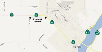 According to the CTC minutes, another project near the town of Rio Vista approved for
future funding will widen shoulders on Route 12 from Azevedo Road to
Liberty Island Road, and construct left turn pockets at Currie, McCloskey
and Azevedo Roads. The project is programmed in the 2010 State Highway
Operation and Protection Program. Total estimated project cost is
$16,821,000 for capital and support. Construction is estimated to begin in
Fiscal Year 2013-14.
According to the CTC minutes, another project near the town of Rio Vista approved for
future funding will widen shoulders on Route 12 from Azevedo Road to
Liberty Island Road, and construct left turn pockets at Currie, McCloskey
and Azevedo Roads. The project is programmed in the 2010 State Highway
Operation and Protection Program. Total estimated project cost is
$16,821,000 for capital and support. Construction is estimated to begin in
Fiscal Year 2013-14.
In March 2013, it was reported that there were concerns that a long-planned, $12 million project west of Rio Vista to widen the shoulders of the narrow highway from Azevedo Road to Summerset Road, a distance of a mile, and to add left turn lanes at Currie, McCloskey and Azevedo roads doesn’t go far enough. Caltrans needs right of way from a rural industrial park owned and operated by Robert Cattey and his brother to move forward. Cattey wants the project modified to ease what he sees as safety and flooding issues affecting his property. Specifically, Cattey wants a left-turn lane on westbound Route 12 at Cattey Lane leading into the industrial park. The park is home to a variety of tenants, ranging from a crane and rigging company to an equipment yard to a heating and air conditioning business. Large cranes turn left from westbound Route 12 into the industrial park daily. They wait for a gap in eastbound traffic and back up traffic, creating a safety hazard. The problem is that Cattey Lane is a private road. Public funds are not typically used to pay for left-turn lanes into private property. Also, a September 2012 traffic assessment showed no congestion or operational problems there. Cattey would also like a culvert enlarged or a new culvert created to ease flooding problems. Caltrans responded that the project won’t make flooding worse and is designed to address safety, not flooding issues. This project is the last of a series of Route 12 safety projects. Others included the widening the highway and smoothing out of “roller coaster” hills near the Western Railway Museum in 2009 and 2010.
Church Road Intersection Improvements (04-Sol-12, PM 24.3/25.2)
In October 2017, the CTC approved for future
consideration of funding a project located northwest of the city of Rio
Vista in Solano County (04-Sol-12, PM 24.3/25.2), proposes to construct
turn lanes and road shoulders on Route 12, a two lane highway. The project
funding will come from local sources estimated at $4.6 million, which
includes Construction (capital and support) and Right -of -Way (capital
and support). The project is not programmed. Construction is estimated to
begin in Fiscal Year 2018-19.
(Source: October 2017 CTC Agenda Item 2.2c.(1))
The 2018 STIP, approved at the CTC March 2018 meeting, appears to allocate $1.939M for construction and construction support in FY19-20 for PPNO 2251A, Rt 12/Church Rd, intersection improvements. (~ SOL 24.82)
The 2020 STIP, approved at the March 2020 CTC meeting,
adjusted the programming for PPNO 2251A Rt 12/Church Rd, intersection
improvements to move the programmed funds from FY20-21 to FY21-22.
(Source: March 2020 CTC Agenda, Item 4.7, 2020 STIP
Adopted 3/25/2020)
In May 2021, the CTC received notice that the Solano
Transportation Authority (STA) proposes to delay construction for the
Route 12/Church Road Intersection Improvements project (PPNO 2251A) in
Solano County. The Route 12/Church Road Intersection Improvements project
(PPNO 2251A) is currently programmed in the STIP with $1,939,000 in
Regional Improvement Program (RIP) funds for construction in Fiscal Year
2021-22. The scope of work includes construction of a left-turn
pocket on eastbound Route 12, a right-turn deceleration/acceleration lane
on westbound Route 12, and protected pocket for left-turns from Church
Road to eastbound Route 12. The project limits for this project lie within
the project limits of a larger roadway rehabilitation project funded with
State Highway Operation and Protection Program (SHOPP) funds. In order to
realize project delivery efficiencies and to minimize traffic impacts to
the travelling public, both projects are planned to be combined into a
single construction contract. The SHOPP project is scheduled to be
ready for delivery in 2022-23. Therefore, STA is proposing to delay
construction of the Route 12/Church Road Intersection Improvements project
from 2021-22 to 2022-23. This STIP amendment was approved at the June 2021
CTC Meeting.
(Source: May 2021 CTC Agenda, Agenda Item 2.1b.(5);
June 2021 CTC Agenda, Agenda Item 2.1a.(7))
Helen Madere Memorial Bridge (Rio Vista Bridge) in Rio Vista (04-Sol-12, 026.24, Bridge 23-0024; 03-Sac-12 0.0/0.4)
The SAFETEA-LU act, enacted in August 2005 as the reauthorization of TEA-21, provided the following expenditures on or near this route: High Priority Project #1414: Rio Vista Bridge Realignment Study & Street Sign Safety Program. $560,000.
The state is currently exploring several proposals to alleviate the traffic backups that result whenever the Rio Vista Bridge is raised to allow boat traffic to pass. The long-term project would involve moving or replacing the drawbridge that spans the Sacramento River and widening Route 12. The source of funding will determine whether the approaches under consideration move forward. The problem is that because the lift bridge is so close to the surface of the water, the operator must raise its spans nearly every time a vessel needs to get to the other side, which can be as often as 10 times a day. Raising and lowering the spans takes about 10 to 25 minutes depending on the size of the craft, causing vehicles to back up in each direction: As many as 440 vehicles have been stopped when a large boat is passing through. In June, an engineering firm that Rio Vista hired to delve into the matter presented its findings in a report that also outlined alternatives to the status quo. The possibilities include widening the section of Route 12 that transects the city and replacing the Rio Vista Bridge with a taller, wider one, to bore a four-lane tunnel under the Sacramento River or build an equally broad bridge that's 50 feet above the water's surface, to divert Route 12 to Airport Road, widen that route, and construct a bridge where it currently dead ends at the river—that bridge would be 145 feet tall, providing sufficient clearance for any oceangoing tanker. Based on public comments received, the preference was a four-lane tunnel along the path of the existing Route 12—a project that estimates peg at $1.8 billion.
In June 2016, it was reported that Caltrans had
scheduled informational meetings to discuss two projects on the Helen
Madere Bridge (formerly the Rio Vista Bridge, renamed in 1998) near Rio
Vista and how that work will affect motorists and river navigation. The
first phase of the work would be cleaning and repainting the steel Route 12 bridge, which crosses the Sacramento River. The existing coating system
on (the bridge) is deteriorating in different locations. There are rust
spots along the truss, tower and floor system members, and rusting around
many of the truss gusset plate nuts and bolts. The work is scheduled to
begin in the fall of 2017 and be completed in the spring of 2022. The cost
is $37 million. The second project, with a $19.2 million budget yet to be
approved, proposes to “maintain the operation and structural
integrity of the drawbridge by replacing the mechanical and electrical
systems." Two elevators also would be replaced and a 4-inch sewer line
will be installed. If the funding is approved, the second project would
begin in 2022 and be completed the next year.
(Source: Daily Republic, 6/17/2016)
In February 2018, it was reported that work was
starting on the Rio Vista Bridge project. The project will preserve the
Rio Vista Bridge over the Sacramento River by cleaning the surface,
removing the old paint and then repainting all steel surfaces. The work is
expected to take two to three years to complete. The drawbridge will
remain open to traffic throughout the project. However, one of the two
lanes on the bridge will be closed during the overnight hours on weekdays
and some weekends to accommodate crews. Bicycle and pedestrian access will
remain open. Motorists can expect delays because of the one-way traffic
controls.
(Source: Caltrans District 3 Press Release, 1/30/2018)
In August 2018, the Helen Madere Memorial Bridge
in Rio Vista got stuck in the “up” position above Route 12,
leaving no way for cars to cross the Sacramento River and stalling
traffic. At the time, Caltrans said engineers were working on a
“mechanical problem” that was expected to be fixed by that
evening. Later, it tweeted that its electrical team estimates repairs
would take until the next morning. They eventually got it fixed, but then
the bridge got stuck in the down position, preventing large ships from
entering and exiting the Port of West Sacramento. Caltrans officials then
expected it would take an additional 30 days for the repairs to be made as
they've had to ship out the broken gearbox to the East Coast be fixed. In
September, ongoing, intermittent repair work on the Rio Vista Bridge let
to major backups and numerous detours for drivers on Route 12, I-5, I-80
and surrounding roads. The mechanism that raises and lowers the Rio Vista
Bridge has been damaged since Aug. 9. Repair work has forced closures of
the bridge off and on since then.
(Source: Sacramento Bee, 8/9/2018; KCRA, 8/14/2018; Sacramento Bee, 9/7/2018)
In October 2018, the CTC amended the 2018 SHOPP
to include the following project: 03-Sac-12 0.0/0.4 PPNO 5962. Project
0319000026. EA 4H690. Route 12 Near Rio Vista, at the Sacramento River
(Rio Vista) Bridge No. 23-0024. Repair electrical, mechanical, and
structural damaged components of bridge. Total Est. Cost $3,900,000. Est.
completion: FY19.
(Source: October 2018 CTC Agenda Item 2.1a.(1) Item
7)
In the Summer 2019 Mile Marker, it was reported that
two director’s orders also have been approved to repair, replace and
upgrade electromechanical components on the Rio Vista Bridge totaling
about $10 million. The span that now stands, built in 1944, is getting a
major overhaul. (The original Rio Vista bridge opened in 1919, but no part
of it remains.) As part of the Rio Vista Bridge Preservation Project, a
massive cleaning and repainting job is now underway, a $20 million effort
scheduled to continue through spring 2020. Upgrades of the bridge’s
core working components are planned next, while deck and rail improvements
and other roadway fixes, including ADA upgrades, will be the focus of
another project scheduled for 2022. Rio Vista is one of the few vertical
lift bridges in the system (Three Mile Slough on Route 160 and the Tower
Bridge, Route 275, are the others), and sees 24,000 daily vehicle trips.
(Source: Mile Marker, Summer 2019)
In January 2020, the CTC was informed of the following
supplemental allocation: $20,350,000 for PPNO 5962, ProjID 0319000026, EA
4H690, 03-Sac-12 0.0/0.4. Route 12 Near Rio Vista, at the Sacramento River
(Rio Vista) Bridge No. 23-0024. Repair electrical, mechanical, and
structural damaged components of bridge. This supplemental is needed to
complete additional work to repair and replace additional deficient
electrical and mechanical equipment and systems and replacement of the
lift-span deck to support mechanical component resiliency and long-term
operation. Initial G-11 Allocation 08/21/18: $3,800,000. Supplemental G-11
Allocation 09/26/18: $8,000,000. Supplemental G-11 Allocation 12/11/19:
$20,350,000.
(Source: January 2020 CTC Agenda, Agenda Item
2.5f.(1) #6)
In March 2021, it was reported that by the end 2022,
all the major electrical work and control systems on the Rio Vista Bridge
will be completed. A backup system will be implemented, for which the
components are being fabricated nationally and will be installed. Benicia,
Calif.-based Golden State Bridge Inc. is the prime contractor and was
awarded the project because of its expertise, and is set to complete work
per schedule. Specialized teams are brought in to focus on specific tasks
such as subcontractors for electricals and millwrights for gearbox
installations. Some of the larger items incorporated in the electrical and
mechanical systems include VFDs (variable frequency drive) and PLCs
(programmable logic controller) by Siemens, Nuttall gear boxes, Steward
Machine span locks, Ringspann brakes and MCCs (motor control center
cabinets) by TESCO. The bridge operational system is being updated with
monitoring technology along with a host of other improvements. This
includes SCADA (supervisory control and data acquisition), a control
system architecture that monitors and controls field devices at remote
sites, collecting and processing real-time data for high-level supervisory
process management. Senior Bridge Engineer Høgni Setberg explains,
"The existing operating system is an old-style mechanical system where if
something breaks, you have to go out to the field to diagnose what the
issue is. With SCADA, every component is monitored through a computer, and
if something isn't working right, we will get a notice exactly which
component is not functioning." This drawbridge, originally built in the
mid-1900s, malfunctioned in August 2018. It has a lift span of 300 ft. and
a structure length of 2,890 ft. It also plays a significant role in local
maritime traffic, serving as the main channel for cargo ships to get in
and out of the Port of West Sacramento. The bridge malfunction resulted
from damaged gear assemblies, rendering the two-lane, continuous truss
span, vertical lift bridge — typically raised for maritime traffic
to head through and then lowered for vehicular traffic — inoperable,
causing unexpected closures and delays.
(Source: Construction Equipment Guide, 3/24/2021)
For all the work on the Rio Vista Bridge, it still is
plagued with mechanical problems. Built in 1944, the aging bridge was also
stuck in the up position a couple of times in 2018 after the gearboxes
that controlled it broke. When it breaks, the closest detour is an 80-mile
route: Route 160 towards Antioch, then Route 4 onto I-680, then I-680 to
Route 12 to Rio Vista. Further, when the bridge is stuck, river traffic is
also impacted. In August 2022, a ship had to anchor just north of the
bridge because it too couldn't get by after the bridge was stuck in the
"up" position. Operators say it costs owners $20,000 for every day that a
vessel sits idle.
(Source: CBS News Sacramento, 8/31/2022)
There was once a project to close a gap in this route near Kettleman Lane (near the Mokelumne River). This was removed from the STIP in early 2004.
Mokelumne River Bridge Improvements (SAC 000.01)
In September 2011, the CTC approved for future consideration of funding a project on Route 12 in San Joaquin County that will rehabilitate the existing Mokelumne River Bridge and control house near the town of Rio Vista. The project is programmed in the 2010 State Highway Operation and Protection Program. Total estimated project cost is $5,425,000 for capital and support. Construction is estimated to begin in Fiscal Year 2013-14. The scope as described for the preferred alternative is consistent with the project scope programmed by the Commission in the 2010 State Highway Operation and Protection Program (SHOPP). A copy of the MND has been provided to Commission staff. The project will mitigate potential impacts to cultural resources to a less than significant level. Potential impacts to cultural resources in the project area will be mitigated by compliance with the Secretary of the Interiors Standards for the Treatment of Historic Properties. A record of the bridge’s historic features will also be developed. As a result, a MND was completed for this project.
In November 2015, it was reported that the Mokelumne
River Bridge Project on Route 12 was complete.This $14 million project
replaced the existing concrete bridge deck, removed and replaced existing
electrical components, and increased the vertical clearance of the control
house. The bridge, constructed in 1942, is one of only 21 remaining
swing-truss bridges in California. The project, slated to take two years
to complete, was completed in only one year. Caltrans along with local
residents, business owners, Coast Guard and levee districts worked
collectively to create a construction schedule that minimized impact to
local businesses, residents, and the motoring and marine public. In
addition, the hard work by the contractor Myers & Son’s
Construction allowed for six full weekend closures of Route 12 to be
reduced to only four.
(Source: ThePineTree.Net, 11/16/2015)
In the Summer 2019 Mile Marker, it was noted that the
Mokelumne River Bridge along Route 12, a busy recreational opening to the
Delta, saw the most boat traffic in 2017, with 1,399 openings and 1,829
vessels passing through — almost 90 percent of them were personal
craft.
(Source: Mile Marker, Summer 2019)
In June 2016, the CTC added the following to the SHOPP: 03-Sac-12 0.4/0.9 Route 12: Near Rio Vista, at Route 160. Intersection improvements. $6K (R/W) $2,468K (C) $2,000K (Support) PA&ED: 08/01/2018 R/W: 09/01/2019 RTL: 09/15/2019 BC: 03/15/2020
Rte 12 - Bouldin Island Project (SJ 0.1 to SJ R4.654)
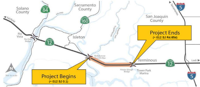 In March 2013, the CTC authorized $32,589,000 to replace 8.6 lane miles of existing roadway near
Terminous on Bouldin Island, from Mokelumne River Bridge to Potato Slough
Bridge (SJ 0.1 to SJ R4.654) with a new structural section to the south
including wider shoulders and concrete median barrier in order to reduce
pavement maintenance cost and frequency, and improve traffic safety.
In March 2013, the CTC authorized $32,589,000 to replace 8.6 lane miles of existing roadway near
Terminous on Bouldin Island, from Mokelumne River Bridge to Potato Slough
Bridge (SJ 0.1 to SJ R4.654) with a new structural section to the south
including wider shoulders and concrete median barrier in order to reduce
pavement maintenance cost and frequency, and improve traffic safety.
The Bouldin Island Project will construct a new roadway section of Route 12 in San Joaquin County on Bouldin Island from the Sacramento County line from the Mokelumne River Bridge to Potato Slough Bridge. The project will construct two 12-foot lanes with standard 8-foot outside shoulders and 5-foot inside shoulders and a concrete median barrier. This project began construction in the spring of 2014. The purpose of this project is to improve the structural section at various locations that have deteriorated due to the underlying oiled sand and to improve safety by widening shoulders and installing rumble strips. This project is needed because the existing shoulder width does not meet current standards and because the structural section contains oiled sand under the asphalt pavement, which led to settlement and cracking of the pavement at several locations within project limits. The project is funded by the State Highway Operation and Protection Program (SHOPP) and 201.120 Roadway Rehabilitation 3R Program, with a total project cost of $58,870,000.
Project completion is planned for October 2018.
In November 2018, it was reported that Caltrans
recently completed the $62.3 million Route 12 Bouldin Island
Rehabilitation Project, which made improvements to the roadway and
enhanced safety elements for motorists traveling through the San Joaquin
Delta corridor. This project improved structural sections of Route 12
between the Mokelumne River Bridge and Potato Slough Bridge, east of the
city of Lodi, due to soil instability under the asphalt pavement that
cracked the road surface. The project also improved traffic safety as
motorists traveling on this section of Route 12 will now enjoy newly
constructed 12-foot travel lanes, 8-foot outside shoulders and 5-foot
inside shoulders, as well as the installation of rumble strips and a
center median barrier to help prevent cross-over traffic collisions. A new
elevated section of Route 12 was also constructed to allow for the
movement of farming vehicles and equipment to pass safely underneath the
highway. Route 12 is a key piece of the transportation system within San
Joaquin County as it sees an average of more than 15,000 vehicles,
including more than 2,000 commercial trucks, on the highway each day. The
project was awarded to O.C. Jones & Sons Inc., of Berkeley. Work began
in spring 2014 and was completed on October 31, 2018.
(Source: Caltrans District 10 FB Post, 11/8/2018)
Jackson Slough Road Traffic Signal (03-Sac-12 3.5/3.8)
In January 2023, the CTC added the following capital
project into the 2022 SHOPP: 03-Sac-12 3.5/3.8. PPNO 03-5964; ProjID
0322000248; EA 3J310. Route 12 Near Rio Vista, at the intersection with
Jackson Slough Road. Install traffic signal. Allocation ($ × 1,000):
PA&ED $840; PS&E $800; R/W Sup $140; Con Sup $990; R/W Cap $33;
Const Cap $3,600; TOTAL $6,403. FY23-24.Concurrent COS allocation under
Resolution FP-22-45; January 2023. Begin Const: 10/10/2024.
(Source: January 2023 CTC Agenda, Agenda Item 2.1a.(1a) #8)
In January 2023, the CTC approved pre-construction
project phase allocation of $840,000. 03-Sac-12 3.5/3.8. PPNO
03-5964; ProjID 0322000248; EA 3J310. Route 12 Near Rio Vista, at the
intersection with Jackson Slough Road. Install traffic signal. Allocation:
PA&ED $840,000. Concurrent Amendment under SHOPP Amendment 22H-006;
January 2023.
(Source: January 2023 CTC Agenda, Agenda Item 2.5b.(2a) #4)
In June 2023, the CTC amended the following project in
the 2022 SHOPP: 03-Sac-12 3.5/3.8. PPNO 03-5964; ProjID 0322000248; EA
3J310. Route 12 Near Rio Vista, at the intersection with Jackson Slough
Road. Install traffic signal. Note: Another safety project is being
proposed on Route 12 to install median barrier with overlapping project
limits with this project. Additional alternatives need to be evaluated to
determine a feasible, effective, and long-term solution at this location.
Additional time is needed to study these alternatives, delaying the
project by two years. No change in allocation; FY changed to FY25-26.
(Source: June 2023 CTC Agenda, Agenda Item 2.1a.(1d) #17)
Potato Slough Bridge Improvements (SJ R4.741 to SJ 10.112)
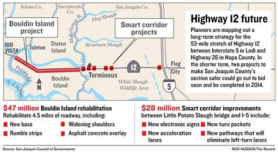 In July 2011, it was reported that two projects were planned to improve safety in this section of the route. One
is roughly $25 million in improvements from Potato Slough Bridge to I-5.
Among other things, it would install left-turn pockets and acceleration
lanes for vehicles entering the highway. Cameras would also be used to
monitor traffic conditions and provide real-time information on new
electronic signs along Route 12. A roughly $50 million project would add
shoulders to the road and a permanent concrete barrier in the median along
the four-and-a-half mile stretch from Mokelumne River to the Potato Slough
bridges (see above).
In July 2011, it was reported that two projects were planned to improve safety in this section of the route. One
is roughly $25 million in improvements from Potato Slough Bridge to I-5.
Among other things, it would install left-turn pockets and acceleration
lanes for vehicles entering the highway. Cameras would also be used to
monitor traffic conditions and provide real-time information on new
electronic signs along Route 12. A roughly $50 million project would add
shoulders to the road and a permanent concrete barrier in the median along
the four-and-a-half mile stretch from Mokelumne River to the Potato Slough
bridges (see above).
(Source: Recordnet.Com)
In August 2011, the CTC approved $11.5 million toward improvements of a section of Route 12 west of I-5 that has long been notorious for deadly accidents. A key improvement will reroute Tower Park Way under Potato Slough Bridge to connect with Glasscock Road. That will allow cars traveling to and from Tower Park Marina to enter and exit the highway without crossing traffic. New cameras and sensors monitor the area and will signal problems and alert motorists using signs posted in locations along Route 12, including to the east of I-5. The project also will expand a park-and-ride lot that already exists at Route 12 and the interstate.
In September 2011, the CTC approved for future consideration of funding a project to rehabilitate the Little Potato Slough Bridge on Route 12 near the city of Lodi and the Route 120 Connector Overhead at I-5 near the town of Mossdale. The project will replace bearing pads and joint seals. The project is programmed in the 2010 State Highway Operation and Protection Program. The total estimated cost is $4,585,000 for capital and support. Construction is estimated to begin in Fiscal Year 2013-14. The scope as described for the preferred alternative is consistent with the project scope programmed by the Commission in the 2010 State Highway Operation and Protection Program (SHOPP). A copy of the MND has been provided to Commission staff. The project will mitigate potential impacts to wetlands and other biological habitat to a less than significant level. Potential impacts to existing wetlands in the project area will be mitigated by restoration to pre-construction conditions. In addition 36 willow trees will be planted in the project area. Preconstruction surveys will be conducted for active nests with work windows being adjusted as necessary. As a result, an MND was completed for this project.
There is a project to construct passing lanes on Route 12 near Terminous from the Sacramento County line to Route 5 (~ SJ 0.221 to SJ 9.969). The environmental process for this project has increased in scope and complexity due to concerns that the Federal Highway Administration (FHWA) had regarding independent utility, geotechnical issues of the Delta soil and a proposed reservoir in the project vicinity that could change environmental conditions. The FHWA concerns have been addressed by a corridor analysis that was recently completed. The corridor analysis resulted in a reevaluation of scope for the project to focus on improvements to Route 12 between Bouldin Island and Route 5. The reevaluation of the scope also addressed the geotechnical issues and the changes in environmental conditions of the proposed reservoir. Therefore, the environmental phase of this project needs to be completed and a preferred alternative selected before proceeding with subsequent phases of the project. These changes place construction beyond FY 2010-11, the last year of the 2006 STIP.
In May 2015, the CTC authorized relinquishment of right of way in the county of San Joaquin along Route 12 between West Terminous Drive (~ SJ M4.98) and Guard Road (~ SJ 8.837), consisting of newly constructed county roads. This area is near Terminous and E of Bouldin Island.
 Double Fine Zones
Between the intersection of Walters Road in Suisun and the intersection with Lower Sacramento Road in Lodi. Authorized by Senate Bill 155, Chapter 169, on July 23, 1999.
Between I-80 and I-5. Authorized by Assembly Bill 112, Chapter 258, on October 1, 2007.
Naming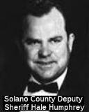 The portion of Route 12 between Pennsylvania
Avenue (~ SOL R4.073) and Marina Boulevard (~ SOL 5.16), near the south
end of Union Avenue and the north end of Main Street, in the County of
Solano (seemingly near Fairfield), is named the "Solano County Deputy
Sheriff Hale Humphrey Memorial Highway". Hale Humphrey grew up in
the New Boston area of eastern Texas prior to enlisting in the United
States Navy. After completing his naval service, Hale Humphrey settled in
Fairfield, initially working for the Fairfield Police Department before
becoming a deputy sheriff with the Solano County Sheriff’s Office.
Deputy Humphrey was active in social activities in Solano County, becoming
a member of the local Elks Lodge and eventually its exalted ruler. On
March 15, 1963, following a robbery at a service station, one of the
fleeing suspects killed a California Highway Patrol officer, and Deputy
Humphrey, who was at a roadblock set up to apprehend the suspects, was
killed in the line of duty when the suspect vehicle rammed the roadblock.
Named by Assembly Concurrent Resolution (ACR) 177, Res. Chapter 135,
Statutes of 2016, on August 23, 2016.
The portion of Route 12 between Pennsylvania
Avenue (~ SOL R4.073) and Marina Boulevard (~ SOL 5.16), near the south
end of Union Avenue and the north end of Main Street, in the County of
Solano (seemingly near Fairfield), is named the "Solano County Deputy
Sheriff Hale Humphrey Memorial Highway". Hale Humphrey grew up in
the New Boston area of eastern Texas prior to enlisting in the United
States Navy. After completing his naval service, Hale Humphrey settled in
Fairfield, initially working for the Fairfield Police Department before
becoming a deputy sheriff with the Solano County Sheriff’s Office.
Deputy Humphrey was active in social activities in Solano County, becoming
a member of the local Elks Lodge and eventually its exalted ruler. On
March 15, 1963, following a robbery at a service station, one of the
fleeing suspects killed a California Highway Patrol officer, and Deputy
Humphrey, who was at a roadblock set up to apprehend the suspects, was
killed in the line of duty when the suspect vehicle rammed the roadblock.
Named by Assembly Concurrent Resolution (ACR) 177, Res. Chapter 135,
Statutes of 2016, on August 23, 2016.
(Image source: Officer Down Memorial Page)
In Suisun City, near Denverton Road off Route 12, there is an "Old Route 12" (somewhere near ~ SOL 12.512).
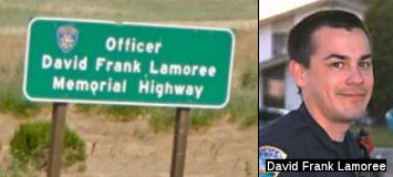 The portion of Route 12 between Olsen Road (~SOL R17.168) and
Route 113 (~ SOL 19.149) is named the "Officer David Lamoree Memorial
Highway". This segment was named in memory of Officer David Frank
Lamoree, who, while driving to his Fairfield home on October 21, 2005, was
hit head-on by a car on Route 12, west of Route 113, on a portion of Route 12 that is only two lanes and that has become increasingly congested and
dangerous. He was taken off of life support on Octber 23, 2005 (his 26th
birthday). Officer David Lamoree was born in Vallejo, California, on
October 23, 1979, and decided on a police career at 10 years of age. He
graduated from Will C. Wood High School, and earned criminal justice
degrees from Solano Community College. He attended the police academy in
Contra Costa County. A police officer for six months at Solano Community
College, Officer Lamoree served on the San Pablo Police Department for a
few years before relocating to the Rio Vista police force. Named by
Assembly Concurrent Resolution (ACR) 7, Resolution Chapter 121, on
9/12/2007.
The portion of Route 12 between Olsen Road (~SOL R17.168) and
Route 113 (~ SOL 19.149) is named the "Officer David Lamoree Memorial
Highway". This segment was named in memory of Officer David Frank
Lamoree, who, while driving to his Fairfield home on October 21, 2005, was
hit head-on by a car on Route 12, west of Route 113, on a portion of Route 12 that is only two lanes and that has become increasingly congested and
dangerous. He was taken off of life support on Octber 23, 2005 (his 26th
birthday). Officer David Lamoree was born in Vallejo, California, on
October 23, 1979, and decided on a police career at 10 years of age. He
graduated from Will C. Wood High School, and earned criminal justice
degrees from Solano Community College. He attended the police academy in
Contra Costa County. A police officer for six months at Solano Community
College, Officer Lamoree served on the San Pablo Police Department for a
few years before relocating to the Rio Vista police force. Named by
Assembly Concurrent Resolution (ACR) 7, Resolution Chapter 121, on
9/12/2007.
(Image source: Find a Grave; SFGate,
10/24/2005)
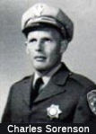 The portion of Route 12, between Route 160 (SAC .57) and Brannan Island Road (SAC 5.84)
in the County of Sacramento is named the "CHP Officer Charles
“Chuck” Sorenson Memorial Highway". It was named in
memory of Officer Charles H. Sorenson, who was born September 6, 1930, to
Earl and RoseMae, in Petaluma, California. In 1957, Officer Sorenson,
badge number 2341, graduated from the CHP Academy. He was assigned to the
El Centro area and later transferred to the Sacramento area. Officer
Sorenson was a hard-working, dedicated officer who loved his job and
enjoyed the people he worked with. He was known for his honesty, fairness,
and dedication, and for being a loyal father and family man. In his spare
time, he enjoyed spending time with his family, playing golf, and building
his 18-foot inboard jet boat named “10-4”. On March 15, 1963,
Officer Sorenson was killed in the line of duty while pursuing a suspect
in his vehicle. During the chase, the suspect lost control of his vehicle,
crashed, and continued to flee on foot. When Officer Sorenson got out of
his car to continue pursuit, a second suspect, of whom he was unaware,
ambushed Officer Sorenson and fired two shots with a stolen handgun at
point blank range. Named by Assembly Concurrent Resolution 100, Resolution
Chapter 109, on September 4, 2012.
The portion of Route 12, between Route 160 (SAC .57) and Brannan Island Road (SAC 5.84)
in the County of Sacramento is named the "CHP Officer Charles
“Chuck” Sorenson Memorial Highway". It was named in
memory of Officer Charles H. Sorenson, who was born September 6, 1930, to
Earl and RoseMae, in Petaluma, California. In 1957, Officer Sorenson,
badge number 2341, graduated from the CHP Academy. He was assigned to the
El Centro area and later transferred to the Sacramento area. Officer
Sorenson was a hard-working, dedicated officer who loved his job and
enjoyed the people he worked with. He was known for his honesty, fairness,
and dedication, and for being a loyal father and family man. In his spare
time, he enjoyed spending time with his family, playing golf, and building
his 18-foot inboard jet boat named “10-4”. On March 15, 1963,
Officer Sorenson was killed in the line of duty while pursuing a suspect
in his vehicle. During the chase, the suspect lost control of his vehicle,
crashed, and continued to flee on foot. When Officer Sorenson got out of
his car to continue pursuit, a second suspect, of whom he was unaware,
ambushed Officer Sorenson and fired two shots with a stolen handgun at
point blank range. Named by Assembly Concurrent Resolution 100, Resolution
Chapter 109, on September 4, 2012.
(Image source: Officer Down Memorial Page)
 The portion of Route 12 between Potato Slough Bridge (~ SJ R004.44) and Route 5 (~ SJ 010.17), in the County of San Joaquin, is named the "Dana
Cowell Memorial Highway". Named in memory of Dana Cowell, who
passed away on January 21, 2012. Cowell was a distinguished California
resident and devoted civic leader, whose good deeds earned him the respect
and admiration of his colleagues and the countless individuals whose lives
he touched, brought immense sorrow and loss to people throughout the
State. Dana Cowell, who brought credit and distinction to himself as
Deputy Director of the San Joaquin Council of Governments (SJCOG), enjoyed
a lifetime of remarkable success in every avenue of his endeavors,
inspiring others through his professional achievements, support of the
community, and strong devotion to family. Dana Cowell joined SJCOG in 2006
after serving in a number of key transportation posts over the course of
26 years with the California Department of Transportation (Caltrans). In
2011, Cowell was named Transportation Manager of the Year by the
California Transportation Foundation for his dedication to overcoming
obstacles to transportation projects. Among Dana Cowell's recent notable
accomplishments are critical safety improvements and construction along
Route 12 through San Joaquin County that began construction in 2012. Dana
Cowell led a partnership with Caltrans to develop intersection upgrades
between Route 5 and Potato Slough Bridge highlighted by the complete
redesign of the Route 12 Tower Parkway Glasscock Road intersection, and
the construction contract for this $20 million project was awarded in
early January 2012. Projects on Route 5, Route 99, Route 205, and Arch
Road in Stockton all benefitted from Dana Cowell's commitment to
transportation. Dana Cowell also worked with Sacramento and Bay Area
transportation leaders to craft the Northern California Trade Corridor
Projects, directed SJCOG's organization of the Valley Wide State
Transportation Improvement Program, and initiated SJCOG efforts to advance
modeling techniques and planning tools in response to Senate Bill No. 375
of the 2007-08 Regular Session (Ch. 728, Stats. 2008), which requires
reductions of greenhouse gas emissions. Dana Cowell was well known and
respected by transportation planners throughout the state, and his
significant knowledge and contributions, dedication, and warm friendship
will be missed in the profession. Named by Senate Concurrent Resolution
85, Resolution Chapter 103, on August 29, 2012.
The portion of Route 12 between Potato Slough Bridge (~ SJ R004.44) and Route 5 (~ SJ 010.17), in the County of San Joaquin, is named the "Dana
Cowell Memorial Highway". Named in memory of Dana Cowell, who
passed away on January 21, 2012. Cowell was a distinguished California
resident and devoted civic leader, whose good deeds earned him the respect
and admiration of his colleagues and the countless individuals whose lives
he touched, brought immense sorrow and loss to people throughout the
State. Dana Cowell, who brought credit and distinction to himself as
Deputy Director of the San Joaquin Council of Governments (SJCOG), enjoyed
a lifetime of remarkable success in every avenue of his endeavors,
inspiring others through his professional achievements, support of the
community, and strong devotion to family. Dana Cowell joined SJCOG in 2006
after serving in a number of key transportation posts over the course of
26 years with the California Department of Transportation (Caltrans). In
2011, Cowell was named Transportation Manager of the Year by the
California Transportation Foundation for his dedication to overcoming
obstacles to transportation projects. Among Dana Cowell's recent notable
accomplishments are critical safety improvements and construction along
Route 12 through San Joaquin County that began construction in 2012. Dana
Cowell led a partnership with Caltrans to develop intersection upgrades
between Route 5 and Potato Slough Bridge highlighted by the complete
redesign of the Route 12 Tower Parkway Glasscock Road intersection, and
the construction contract for this $20 million project was awarded in
early January 2012. Projects on Route 5, Route 99, Route 205, and Arch
Road in Stockton all benefitted from Dana Cowell's commitment to
transportation. Dana Cowell also worked with Sacramento and Bay Area
transportation leaders to craft the Northern California Trade Corridor
Projects, directed SJCOG's organization of the Valley Wide State
Transportation Improvement Program, and initiated SJCOG efforts to advance
modeling techniques and planning tools in response to Senate Bill No. 375
of the 2007-08 Regular Session (Ch. 728, Stats. 2008), which requires
reductions of greenhouse gas emissions. Dana Cowell was well known and
respected by transportation planners throughout the state, and his
significant knowledge and contributions, dedication, and warm friendship
will be missed in the profession. Named by Senate Concurrent Resolution
85, Resolution Chapter 103, on August 29, 2012.
(Image source: California Transportation Foundation; Recordnet 1/25/2012)
Named Structures The Rio Vista Bridge (SOL 026.24) is officially named the "Helen Madere
Memorial Bridge". Ms. Madere was a former vice-mayor of Rio Vista,
who was a key force behind the safety improvements that established a
safety enhancement-double fine zone between Lodi and Suisun City on Route 12. It was named in memory of Helen Madere, the former Vice-Mayor of the
City of Rio Vista, who is remembered for her efforts to improve the safety
of driving on Route 12. As President of the Highway 12 Association, Ms.
Madere was a key force behind the safety improvements outlined in House
Resolution 45 (by Assembly Member Hannigan) of the 1993-94 Regular Session
of the Legislature, and Assembly Bill 827 (by Assembly Member Thomson, Ch.
709, Stats. 1997) which established a "Safety Enhancement-Double Fine
Zone" between the City of Lodi and the City of Suisun City on Route 12. As
Rio Vista's representative to the Solano County Transportation Authority,
Ms. Madere was known as an advocate for advancing regional transportation
projects. Ms. Madere, who had an accounting background and owned a tax
preparation business, was instrumental in helping Rio Vista recover from a
financial crisis during the 1980's. She was also an active participant in
many civic and community activities in Rio Vista since moving there in
1959. She was also a member of the Rio Vista City Council. Named by
Assembly Concurrent Resolution 100, Chapter 124, in 1998.
The Rio Vista Bridge (SOL 026.24) is officially named the "Helen Madere
Memorial Bridge". Ms. Madere was a former vice-mayor of Rio Vista,
who was a key force behind the safety improvements that established a
safety enhancement-double fine zone between Lodi and Suisun City on Route 12. It was named in memory of Helen Madere, the former Vice-Mayor of the
City of Rio Vista, who is remembered for her efforts to improve the safety
of driving on Route 12. As President of the Highway 12 Association, Ms.
Madere was a key force behind the safety improvements outlined in House
Resolution 45 (by Assembly Member Hannigan) of the 1993-94 Regular Session
of the Legislature, and Assembly Bill 827 (by Assembly Member Thomson, Ch.
709, Stats. 1997) which established a "Safety Enhancement-Double Fine
Zone" between the City of Lodi and the City of Suisun City on Route 12. As
Rio Vista's representative to the Solano County Transportation Authority,
Ms. Madere was known as an advocate for advancing regional transportation
projects. Ms. Madere, who had an accounting background and owned a tax
preparation business, was instrumental in helping Rio Vista recover from a
financial crisis during the 1980's. She was also an active participant in
many civic and community activities in Rio Vista since moving there in
1959. She was also a member of the Rio Vista City Council. Named by
Assembly Concurrent Resolution 100, Chapter 124, in 1998.
(Image source: AAroads)
Freeway[SHC 253.2] Entire portion; constructed to freeway standards from Route 80 to Fairfield.
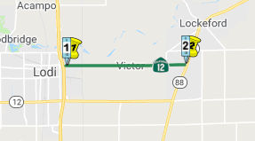 From Route 99 near Lodi to Route 88 near Lockford.
Post 1964 Signage HistoryThis segment is as defined in 1963.
Pre 1964 Signage HistoryIn 1934, Route 12 was signed along the route from Jct. Route 1 near Jenner to San Andreas, via Santa Rosa, Rio Vista, and Lodi. This segment was LRN 24 between US 99 and Route 88. It was defined in 1909.
Freeway[SHC 253.2] Entire portion. Defined as part of the F&E system in 1959.
Naming The portion of Route 12 from the intersection with Rout 99 to a length of five miles to the east (~ SJ 18.144/23.144), in the
County of San Joaquin, is named the "Donald Mark Lichliter Memorial
Highway". It was named in memory of Donald Mark Lichliter, who was
born in Minneapolis, Minnesota, and resided there until he joined the
United States Air Force at 18 years of age. The Air Force brought Donald
to the Sacramento area, and from that time forward he called California
home. Donald was a member of Chapter 263 of the American Legion Riders,
and enjoyed golfing, motorcycling, hunting, and fishing. Donald was a
devoted and hard-working public servant, who worked for Caltrans for over
27 years. Donald met his wife, Mandy, in 1987 and they were married in
1988. Each Tuesday, Donald and Mandy met with their church congregation
where they worked to feed the homeless. On July 23, 2009, Donald was
working as a Caltrans tree maintenance leadworker when he was struck by a
truck as he worked next to his vehicle, and was killed in the line of
duty. Named by Assembly Concurrent Resolution 100, Resolution Chapter 109,
on September 4, 2012.
The portion of Route 12 from the intersection with Rout 99 to a length of five miles to the east (~ SJ 18.144/23.144), in the
County of San Joaquin, is named the "Donald Mark Lichliter Memorial
Highway". It was named in memory of Donald Mark Lichliter, who was
born in Minneapolis, Minnesota, and resided there until he joined the
United States Air Force at 18 years of age. The Air Force brought Donald
to the Sacramento area, and from that time forward he called California
home. Donald was a member of Chapter 263 of the American Legion Riders,
and enjoyed golfing, motorcycling, hunting, and fishing. Donald was a
devoted and hard-working public servant, who worked for Caltrans for over
27 years. Donald met his wife, Mandy, in 1987 and they were married in
1988. Each Tuesday, Donald and Mandy met with their church congregation
where they worked to feed the homeless. On July 23, 2009, Donald was
working as a Caltrans tree maintenance leadworker when he was struck by a
truck as he worked next to his vehicle, and was killed in the line of
duty. Named by Assembly Concurrent Resolution 100, Resolution Chapter 109,
on September 4, 2012.
(Image source: Caltrans "In Remembrance" Page)
Double Fine Zones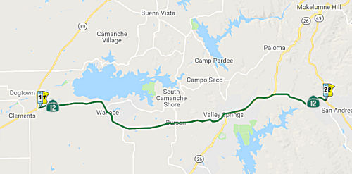 From Route 88 near Clements to Route 49 near San Andreas.
Post 1964 Signage HistoryIn 1963, this segment was defined to be "Route 88 near Clements to Route 49 at San Andreas."
In 1965, the definition was relaxed to be "near San Andreas".
Pre 1964 Signage HistoryIn 1934, Route 12 was signed along the route from Jct. Route 1 near Jenner to San Andreas, via Santa Rosa, Rio Vista, and Lodi. This segment was LRN 24. It was defined in 1909.
 In 1953, it was reported that a change was being made in how Route 88
connected to Route 12. The CHC had approved the new connection, and
contractors were bidding to construct the new segment. Originally, Route 88 ran along Mackville Road and Collier Road E. This was replaced with a
new direct connection. The new location for Route 88 is a 1.4 mi section,
and includes a new concrete reinforced bridge. At the same time, work was
being performed to realign the existing Route 12 in this area, eliminating
sharper curves and rolling grades, reconstructing the highway as a modern
two-lane roadway using the existing road as a base where possible.
In 1953, it was reported that a change was being made in how Route 88
connected to Route 12. The CHC had approved the new connection, and
contractors were bidding to construct the new segment. Originally, Route 88 ran along Mackville Road and Collier Road E. This was replaced with a
new direct connection. The new location for Route 88 is a 1.4 mi section,
and includes a new concrete reinforced bridge. At the same time, work was
being performed to realign the existing Route 12 in this area, eliminating
sharper curves and rolling grades, reconstructing the highway as a modern
two-lane roadway using the existing road as a base where possible.
(Source: Unnamed publication, 11.20/1953, via Joel Windmiller,
2/6/2023)
StatusNorth Fork Calaveras Creek Bridge № 30-0007 (10-Calaveras-12 PM 17.1/17.5)
 The 2020 SHOPP, approved in May 2020, included the following new Bridge
Preservation item of interest: 10-Calaveras-12 PM 17.3 PPNO 3288 Proj ID
1013000008 EA 0X740. Route 12 Near San Andreas, at North Fork Calaveras
Creek Bridge № 30-0007. Replace bridge. Programmed in FY23-24, with
construction scheduled to start in Oct 2024. Total project cost is
$14,250K, with $8,702K being capital (const and right of way) and $5,548K
being support (engineering, environmental, etc.),
The 2020 SHOPP, approved in May 2020, included the following new Bridge
Preservation item of interest: 10-Calaveras-12 PM 17.3 PPNO 3288 Proj ID
1013000008 EA 0X740. Route 12 Near San Andreas, at North Fork Calaveras
Creek Bridge № 30-0007. Replace bridge. Programmed in FY23-24, with
construction scheduled to start in Oct 2024. Total project cost is
$14,250K, with $8,702K being capital (const and right of way) and $5,548K
being support (engineering, environmental, etc.),
(Source: 2020 Approved SHOPP a/o May 2020)
In February 2022, Caltrans announced public meetings on
the replacement of the North Fork Calaveras Creek Bridge. Caltrans
proposes to replace the bridge on an alternative alignment along Route 12
in Calaveras County. The current bridge has above-average collision rates
and a non-standard bridge railings, width, super-elevation, and horizontal
alignment. The proposed replacement bridge would have two 12' lanes, two
8' shoulders, and new bridge railings to meet current standards. The
product would also involve roadway realignment next to the north side of
the existing bridge and would correct the existing non-standard horizontal
roadway alignment at the west and east ends of the structure.
(Source: District 10 on FB, 2/1/2022)
In June 2022, the CTC approved for future consideration
of funding the following project for which a Mitigated Negative
Declaration (MND) has been completed: 10-Cal-12, PM 17.1/17.5. Calaveras
County Bridge Replacement. Replace the North Fork Calaveras River
Bridge next to its current alignment and realign Route 12 in Calaveras
County. (PPNO 3288) The project is located on Route 12 at postmile 17.1
and 17.5, in Calaveras County. The Department proposes to replace the
North Fork Calaveras Bridge on an alternate alignment along Route 12. The
proposed replacement bridge will have two 12-foot lanes, two 8-foot
shoulders, and new bridge railings to meet current standards. The project
will also involve roadway realignment next to the north side of the
existing bridge and will correct the existing nonstandard horizontal
roadway alignment at the west and east ends of the structure. This project
is currently programmed in the 2022 SHOPP for a project total of
$14,250,000, which includes Right of Way (capital) and Construction
(capital and support). Construction is estimated to begin in 2024-25. The
scope, as described for the preferred alternative, is consistent with the
project scope as programmed by the Commission in the 2022 SHOPP.
(Source: June 2022 CTC Agenda, Agenda Item
2.2c.(1))
In June 2022, the CTC approved the following
pre-construction phase SB1 SHOPP allocation: $2,503,000. 10-Cal-12 17.3.
PPNO 10-3288; ProjID 1013000008; EA 0X740. Route 12 Near San Andreas, at
North Fork Calaveras Creek Bridge № 30-0007. Replace bridge.
Concurrent consideration of funding under Resolution E-22-49; June 2022.
Allocation FY23-24 PS&E $2,396,000 ($2,093,000 programmed); R/W Sup
$107,000 ($90,000 programmed).
(Source: June 2022 CTC Agenda, Agenda Item 2.5b.(2b) #83)
In June 2023, the CTC amended the following project in
the 2022 SHOPP: 10-Cal-12 17.3 17.1/17.6. PPNO
10-3288; ProjID 1013000008; EA 0X740. Near San Andreas, from 0.2 mile
west to 0.3 mile east of at North Fork Calaveras Creek
Bridge № 30-0007. Replace bridge and realign roadway.
Note: Project scope was changed to include roadway realignment to avoid
nonstandard walls and to standardize curvature and super elevation.
Update description, post miles and output due to scope change. Increase
Con Sup due to new alignment and additional working days. Increase Con Cap
due to added scope, cost of revised bridge design, and mitigation
monitoring. Increase R/W Cap due to acquisitions and utility
relocation. Allocation ($ × 1,000): Con Sup $2,293
$2,500; R/W Cap $145 $688; Const Cap $8,557
$16,631.
(Source: June 2023 CTC Agenda, Agenda Item 2.1a.(1d) #76)
Freeway[SHC 253.2] Entire portion. Defined as part of the F&E system in 1959.
 Exit Information
 Other WWW Links
 Interstate Submissions
Route 12 was not submitted to the Interstate system. The designation I-12 was proposed in December 1957 for what is now I-10, based on a recommendation from Arizona, but this was rejected by AASHTO. Sometime prior to that, the designation I-12 was proposed for what is now I-210.
 Statistics
Overall statistics for Route 12:
 Interregional Route
[SHC 164.11] Entire route.
 Pre-1964 Legislative Route
The routing that would become LRN 12 was first defined in the 1909 First Bond Act to run from San Diego to El Centro. It wasn't extended again until 1933, when the segment "[LRN 2], Atlantic Street, San Diego to old Spanish Lighthouse, Point Loma" was added. By 1935, the route was codified into the highway code as being from:
The portion from San Diego to El Centro was considered a primary highway.
In 1953, Chapter 1856 combined these two sections into one, making the definition “Point Loma to El Centro via San Diego.”
There were two segments:
At El Centro, LRN 12 ended, but US 80 continued easterly as LRN 27.
© 1996-2020 Daniel P. Faigin.
Maintained by: Daniel P. Faigin
<webmaster@cahighways.org>.
 Route 11
 Route 13