
 California Highways:
Click here for a key to the symbols used. An explanation of acronyms may be found at the bottom of the page.
 Routing
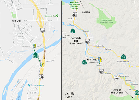 From Route 101 south of Rio Dell to the north end of the Eel River Bridge and
Overhead in Rio Dell.
From Route 101 south of Rio Dell to the north end of the Eel River Bridge and
Overhead in Rio Dell.
 Post 1964 Signage History
In 1970, Chapter 1473 defined Route 283 as “Route 101 south of Rio Dell to the north end of the Eel River Bridge and Overhead in Rio Dell.” This is the shortest route in the state system in terms of defined length, but in terms of constructed length, Route 77 is shorter by 10 feet.
The Rio Dell Bridge was constructed during 1941 over the Eel River and
was built in conjunction with the nearby Robinson Ferry Bridge. The
Rio Dell Bridge is the second alignment of US 101 between the communities
of Rio Dell and Scotia. The Rio Dell Bridge and Robinson Ferry
Bridge replaced two spans that were built during 1914. The Rio Dell
Bridge was nearly wiped out during the 1964 Christmas floods on the Eel
River, but was rebuilt during 1965. The Rio Dell Bridge was spun off
from US 101 into the newly created Route 283 during 1970 whereas the
Robinson Ferry Bridge serves as the NB lanes of US 101.
(Source: Tom Fearer on AARoads, "CA 283 and the Rio Dell Bridge", 7/15/2020)
 Pre 1964 Signage History
This is a former routing of US 101 (LRN 1, defined in 1909).
Prior to the completion of bridges on the Eel River during 1914 traffic
had to utilize ferries to cross north of Scotia (a bridge between Rio Dell
and Scotia existed previously but was wiped out by floods in 1905).
The ferry routes were replaced with steel structures built by Humboldt
County which had 17 foot wide road decks. The new Rio Dell Bridge
and Robinson Ferry Bridge were cited to be of a steel truss construction
with 26 foot wide road decks. Both the Rio Dell Bridge and Robinson
Ferry Bridge were cited to have an anticipated opening of July 1941.
(Source: Gribblenation Blog (Tom Fearer): California State Route 283; former US Route 101 over the Rio Dell Bridge)
 Status
This routing is not signed.
In July 2018, there was an interesting article on the impact of a project
on the Rio Dell Bridge. Rio Dell' is a small city (population 3,400) on
the banks of the Eel River that was once the seamy playground for the
company-town employees of neighboring Scotia, seeing booming business
during the Prohibition era when it was an unincorporated area known as
"Wildwood." Incorporation in 1965 could have stabilized the town, but the
bypass of US 101 in 1973 crippled tourism for a time, and the decline of
the logging industry dealt an additional blow to the town's economy. Rio
Dell once surged on the revenue of 2,500 timber jobs in nearby mills. The
Scotia mill, the last remaining, now employs around 250, according to the
local chamber of commerce. Since then, there has been a long, slow climb
in stability, with a dedicated group of civic boosters advocating for
small business growth, renewed investment in public beautification
projects and an embrace of the legal cannabis industry all contributing to
Rio Dell's renaissance. Between 2016 and 2017, the town's quarterly sales
tax returns rose by almost 57 percent. New businesses — a café,
two massage parlors and a boutique — took root. In March 2018, an
unexpected setback occurred when Caltrans closed the bridge linking Rio
Dell to Scotia to repaint it. At the cusp of tourist season, traffic
slowed to a trickle. The closure is anticipated to last through summer
2018 and longtime business owners say it will mean the death of their
storefronts. The Eagle Prairie Bridge has a unique distinction as the
second-shortest state highway in California (after Route 275 in
Sacramento). Originally part of U.S. Highway 101, the bridge was
re-designated as a transfer from the highway in 1970 and is under the
stewardship of Caltrans. When Caltrans last repainted the bridge in 2001,
it kept it open to one-way traffic. But according to spokesperson Myles
Cochrane, the agency made a different move this year, largely for fiscal
reasons. The full closure of the bridge means a six-month project; one-way
traffic control would stretch the painting job to two years. Full closure
is also safer for workers, Cochrane says. A lighted path has been
established for pedestrians and bicyclists.
(Source: North Coast Journal, 7/5/2018)
In August 2018, it was reported that the Eagle Prairie Bridge, spanning
the Eel River between Rio Dell and Scotia, reopened to vehicle traffic in
early August 2018, just in time for the fun and festivities associated
with the annual Wildwood Days. When the bridge closed for painting in
March, the estimated closure time was six months, with a planned reopening
in early October 2018. However, the contractor brought in additional
workers and that sped up the entire operation. This is a permanent
re-opening of the Eagle Prairie Bridge and no further closure is planned.
There will be controlled traffic on the bridge briefly for center line and
traffic line striping, and installation of reflectors on the striping. The
construction detours signs will also be removed shortly.
(Source: Time Standard, 8/4/2018)
 Named Structures
 Bridge 04-0015 over the Rio Dell-Eel River in Humboldt County (HUM 000.12) is named the "Albert
Stanwood Murphy Memorial Bridge". It was built in 1941, and was
named by Assembly Concurrent Resolution 23, Chapter 91, in 1977. Albert
Stanwood Murphy (b. 1892) was the president of Pacific Lumber and assisted
the "Save the Redwoods League" in setting aside redwood park land. While
Murphy was at Pacific Lumber (PL), PL was a different kind of logging
company. Selective cutting, a policy he first set forth, meant PL cut a
maximum of 70 percent of the mature trees in a stand. PLs practice was
such a drastic change from the industry standard of leaving hillsides
completely barren that, it was often difficult for the untrained observer
to realize that the company’s selectively cut acreage had even been
touched. Sustainable yield, another Albert Murphy policy, also represented
a striking difference between how PL and the rest of the industry did
business. While many companies would routinely cut all of their timber and
promptly go out of business, PLs annual cut would always be limited and
never exceed its timberlands new growth. This way, year after year PLs
gross amount of board feet would never decline. PL could continue this
mode of production indefinitely. Alas, after Murphy was gone and the
company sold to Maxxim, these policies went by the wayside. With respect
to the Redwoods Park, Murphy committed to protecting the trees in
Dyerville and Bull Creek Flats until the Save the Redwoods League could
purchase the land.
Bridge 04-0015 over the Rio Dell-Eel River in Humboldt County (HUM 000.12) is named the "Albert
Stanwood Murphy Memorial Bridge". It was built in 1941, and was
named by Assembly Concurrent Resolution 23, Chapter 91, in 1977. Albert
Stanwood Murphy (b. 1892) was the president of Pacific Lumber and assisted
the "Save the Redwoods League" in setting aside redwood park land. While
Murphy was at Pacific Lumber (PL), PL was a different kind of logging
company. Selective cutting, a policy he first set forth, meant PL cut a
maximum of 70 percent of the mature trees in a stand. PLs practice was
such a drastic change from the industry standard of leaving hillsides
completely barren that, it was often difficult for the untrained observer
to realize that the company’s selectively cut acreage had even been
touched. Sustainable yield, another Albert Murphy policy, also represented
a striking difference between how PL and the rest of the industry did
business. While many companies would routinely cut all of their timber and
promptly go out of business, PLs annual cut would always be limited and
never exceed its timberlands new growth. This way, year after year PLs
gross amount of board feet would never decline. PL could continue this
mode of production indefinitely. Alas, after Murphy was gone and the
company sold to Maxxim, these policies went by the wayside. With respect
to the Redwoods Park, Murphy committed to protecting the trees in
Dyerville and Bull Creek Flats until the Save the Redwoods League could
purchase the land.
(Image source: North Coast Journal; Additional information: The Last Stand)
 This bridge was later renamed the "Eagle Prairie Bridge" by Senate Concurrent Resolution 90, Chapter 79, in
1990. It was named to commemorate the 50th anniversary of its construction
and the 25th anniversary of the incorporation of the city of Rio Dell,
formerly known as Eagle Prairie.
This bridge was later renamed the "Eagle Prairie Bridge" by Senate Concurrent Resolution 90, Chapter 79, in
1990. It was named to commemorate the 50th anniversary of its construction
and the 25th anniversary of the incorporation of the city of Rio Dell,
formerly known as Eagle Prairie.
(Image source: AARoads)
 Other WWW Links
 Statistics
Overall statistics for Route 283:
 Pre-1964 Legislative Route
In 1959, Chapter 1062 defined LRN 283 as:
This route is signed as follows:
© 1996-2020 Daniel P. Faigin.
Maintained by: Daniel P. Faigin
<webmaster@cahighways.org>.
 Route 282
 Route 284