
 California Highways:
Click here for a key to the symbols used. An explanation of acronyms may be found at the bottom of the page.
 Routing
 Post 1964 Signage History
In 1963, Route 123 was defined as the route from "Oakland to Route 80 in Richmond at Cutting Boulevard."
In 1990, Chapter 1187 clarified the definition: "Route 580 at San Pablo Avenue in Oakland to Route 80 in Richmond at Cutting Boulevard."
 Pre 1964 Signage History
 This is the old surface street routing of US 40 along San Pablo Ave.
between Peralta Street and Cutting Blvd. It was LRN 14, defined in 1909.
This was signed as Business US 40 until 1964. Tom Fearer has a good
summary of the history of the US 40 aspects of this route on his
Gibblenation blog California State Route 123/San Pablo Avenue; a trip down Old US Route 40 and the US Route terminus points in the Oakland Area. Former US 40 on
San Pablo Avenue/LRN 14 apparently was signed as US 40 Business until 1964
after the mainline was moved to the East Shore Highway. By the 1964 State
Highway renumbering LRN 14 south of El Cerrito to MacArthur Boulevard was
assigned Route 123 while mainline US 40 was co-signed with I-80.
This is the old surface street routing of US 40 along San Pablo Ave.
between Peralta Street and Cutting Blvd. It was LRN 14, defined in 1909.
This was signed as Business US 40 until 1964. Tom Fearer has a good
summary of the history of the US 40 aspects of this route on his
Gibblenation blog California State Route 123/San Pablo Avenue; a trip down Old US Route 40 and the US Route terminus points in the Oakland Area. Former US 40 on
San Pablo Avenue/LRN 14 apparently was signed as US 40 Business until 1964
after the mainline was moved to the East Shore Highway. By the 1964 State
Highway renumbering LRN 14 south of El Cerrito to MacArthur Boulevard was
assigned Route 123 while mainline US 40 was co-signed with I-80.
Note that Route 123 doesn't cover all of the older surface street routing of US 40. In particular, N of El Cerrito, former US 40, bypassed in 1958, is not part of the state highway. This is probably because the Eastshore Highway originally fed straight into San Pablo Avenue just south of Cutting Boulevard in El Cerrito (next to the current El Cerrito Del Norte BART station); that intersection was the original northern terminus of the 1940 Business US 40. In 1958, the Interstate 80 bypass north to the Carquinez Bridge was built and signed as I-80/US 40; the orphaned portion of Eastshore Highway south of Cutting Boulevard and San Pablo Avenue became a city street, while Business US 40 was extended to San Pablo Avenue north of Cutting all the way to Crockett and Rodeo. So why wasn't Route 123 designated on all of former Business US 40? This has to do with the legislative numbering history. Before the Crockett bypass portion of the Eastshore Freeway was built, the Eastshore Highway was LRN 69 from Eastshore/San Pablo in El Cerrito south to the Macarthur Maze, and San Pablo Avenue was LRN 14 from Eastshore/San Pablo south to then-US 50 (now I-580), connecting back to US 40 (now I-80) via Macarthur Boulevard and Freeway. North of the original Eastshore/San Pablo split, San Pablo Avenue was all LRN 7 to the Carquinez Bridge. But when the Crockett bypass was built for I-80/US 40, LRN 7 was completely moved over to that new freeway and did not apply to the now-business route. Thus, state maintenance did not carry over on the former alignment and only former LRN 14 (plus Cutting Boulevard, which was never part of the US 40 route and only serves to connect San Pablo Avenue with I-80.) Also orphaned by the construction of the 1958 freeway was a very small segment of the Eastshore Highway from Potrero Avenue (at its interchange with I-80) north to San Pablo Avenue; this had formerly been LRN 69 but LRN 69 was redesignated to apply specifically to the freeway in that area. That segment is now known as Eastshore Boulevard and serves to connect eastbound I-80 with northbound Route 123 past the El Cerrito Del Norte BART station. In 1964, when the great renumbering occured, the portion of Business US 40 which was now no longer covered by LRN 7 became local street; the portion of Business US 40 which was still LRN 14 is now Route 123 (which is signed at least at the Cutting/San Pablo and I-80 junction).
Route 123 was not defined as part of the initial state signage of routes in 1934. It is unclear what (if any) route was signed as Route 123 between 1934 and 1964.
 Status
San Pablo Avenue Corridor Project
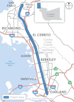 In November 2017, it was reported that a nine-year, $300
million-plus project to accommodate growth on the San Pablo Avenue
corridor — covering more than 13 miles from Richmond’s Hilltop
neighborhood to downtown Oakland — awaits user input. The project,
now in the planning stages, is a partnership of the Alameda County
Transportation Commission, the lead agency, and the West Contra Costa
Transportation Advisory Committee to develop a vision for the corridor
through Richmond, San Pablo and El Cerrito in Contra Costa County, and
Oakland, Emeryville, Berkeley and Albany in Alameda County. The planning
also includes consideration of new development along San Pablo that would
increase foot, motor and bicycle traffic. “Jurisdictions are
concentrating growth along the corridor, with several higher-density,
mixed use developments recently completed and numerous others under
consideration,” notes the project website. Improvements “could include transit priority treatments such as queue jump lanes and signals to bypass congested
segments and improve reliability, transit signal priority, signal
modernization and coordination, and enhanced bus stops or stations,”
as well as measures to enhance bicycle and pedestrian safety. The project
timeline envisions scoping (input), planning, engineering and design
phases through 2024, with construction from winter 2024 to winter 2026.
The estimated cost is $312 million, funded through federal, state and
local sources.
In November 2017, it was reported that a nine-year, $300
million-plus project to accommodate growth on the San Pablo Avenue
corridor — covering more than 13 miles from Richmond’s Hilltop
neighborhood to downtown Oakland — awaits user input. The project,
now in the planning stages, is a partnership of the Alameda County
Transportation Commission, the lead agency, and the West Contra Costa
Transportation Advisory Committee to develop a vision for the corridor
through Richmond, San Pablo and El Cerrito in Contra Costa County, and
Oakland, Emeryville, Berkeley and Albany in Alameda County. The planning
also includes consideration of new development along San Pablo that would
increase foot, motor and bicycle traffic. “Jurisdictions are
concentrating growth along the corridor, with several higher-density,
mixed use developments recently completed and numerous others under
consideration,” notes the project website. Improvements “could include transit priority treatments such as queue jump lanes and signals to bypass congested
segments and improve reliability, transit signal priority, signal
modernization and coordination, and enhanced bus stops or stations,”
as well as measures to enhance bicycle and pedestrian safety. The project
timeline envisions scoping (input), planning, engineering and design
phases through 2024, with construction from winter 2024 to winter 2026.
The estimated cost is $312 million, funded through federal, state and
local sources.
(Source: East Bay Times, 11/20/2017)
In February 2022, it was reported that the San Pablo Avenue Corridor Project, a joint effort between seven cities, two counties (Alameda and Contra Costa), and the state of California, has
been quietly and steadily moving forward since 2016. It is a part of Plan
Bay Area 2040, a massive state-mandated transit and land-use project that
will invest approximately $300 billion in the region over 24 years. Phase
one of the San Pablo project, which wrapped in Winter 2021, created a
long-term vision for the corridor, drawing on years of studies by the
Alameda County Transportation Commission, AC Transit, and others. That
vision—a vibrant transit hub with dedicated lanes for faster, likely
electric buses, wide bike lanes, and improved walking
infrastructure—is expected to be realized by 2040. Phase two
will involve the finalizing of plans, additional fundraising, and initial
design changes in the four participating Alameda County cities: Oakland,
Berkeley, Emeryville, and Albany. By the end of 2022, final street safety
designs should be approved by the county transportation commission and
city councils in the four cities. Funding will be solicited from state
agencies, and grants could also be awarded by year’s end. And city
transportation agencies will hold public meetings and conduct community
outreach to residents and businesses to solicit feedback and address any
design or equity concerns. In 2017, the ACTC funded a $1.75 million study
of the existing conditions along San Pablo Avenue. The goal was easy to
explain but difficult to execute: Find out what’s working about San
Pablo, and what’s not, across multiple cities. The report would also
include a survey of community members in each city that sought to find how
they used the corridor and what the biggest transit challenges were,
including the lack of signage, congestion spots, and broken facilities.
The study looked at the entirety of San Pablo Avenue, from Oakland in the
south to Richmond in the north. It was felt to be critical to include the
parts of San Pablo Avenue that are in Contra Costa County as travelers
don’t have the same boundaries as government agencies. The report
was published in 2018 and found that most collisions on San Pablo Avenue
happened within 100 feet of intersections, mostly affecting bikers and
walkers. Crossing the street was also difficult because it lacked medians,
adequate crossing signals, and stop infrastructure. The study also
revealed that the southern portion of San Pablo Avenue, particularly
between 40th Street and Broadway in Oakland, is one of the most dangerous
sections to walk or bike. The central portion, comprising Berkeley,
Albany, and El Cerrito, has the most car collisions. One intersection on
Solano Avenue in Albany was found to be the most dangerous spot for
bicyclists.
(Source: Oaklandside, 2/17/2022)
 By late 2018 and into 2019, after months of community focus groups and business
outreach, the county commission engaged with city transportation
departments to develop new road designs. Together, they came up with four
options:
By late 2018 and into 2019, after months of community focus groups and business
outreach, the county commission engaged with city transportation
departments to develop new road designs. Together, they came up with four
options:
(Source: Oaklandside, 2/17/2022)
When presented with the options, the cities disagreed
about which design elements were best. However, the four cities in Alameda
County were able to narrow down the possible options. Oakland and
Emeryville would use parts of concepts A and B, while Berkeley and Albany
would mix in concepts A, B, and D. Throughout the community outreach
process, commissioners heard from residents, especially in the four
Alameda County cities, who expected near-term fixes to improve
safety. By the end of 2021, all four of the participating cities in
Alameda County—Oakland, Emeryville, Berkeley, and
Albany—decided that it was in the public interest to pilot a program
to increase safety on San Pablo Avenue within 3-5 years. County officials
say this timeline will allow for the approval of final designs and
funding. Initial improvements in all four cities will include pedestrian
crossings with loud, audible signals, easy-to-see crosswalks with diagonal
striping, and rapid flashing beacons controlled by pedestrians that alert
cars to slow down. Bus stops will also get a refresh, with new curb ramps
to help disabled people better access public transportation, while some
will get improved lighting and hardware fixes, including new seats.
Dedicated bus and bike lanes will be added in Oakland and Emeryville.
Where the new bus lanes will be placed—in the middle of the street
or next to the sidewalk—has not been decided. OakDOT officials,
however, are leaning toward the latter. The pilot will also add better
crossing tech at road intersections (a big win for bicyclists), including
on transit hubs like Grand Avenue in West Oakland. However, the new bus
and bike lanes proposed for Oakland and Emeryville will only extend a few
blocks into Berkeley. That’s because the Alameda County
Transportation Commission decided against building transit lanes through
Berkeley and Albany, citing “significant concerns” heard
during the project’s public outreach about taking a lane away from
cars and reducing parking along the avenue. Instead of dedicated lanes,
plans call for building upgraded “in-lane” bus stops through
the rest of Berkeley and Albany that will let drivers pick up and drop off
riders without having to pull over or merge back into traffic, which
should make boarding faster. The project would also fund traffic-calming
measures to encourage bicyclists to use Ninth Street as a parallel route
to San Pablo, as well as improved intersections to make crossing the
avenue safer for pedestrians.
(Source: Oaklandside, 2/17/2022)
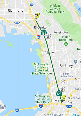
As the portion of San Pablo Avenue between I-580 in
Oakland and I-80 in Richmond (which includes Berkeley), is a state highway
(Route 123), ACTC needs approval from the California Department of
Transportation for any design or structural additions. According to the
ACTC, its officials are in weekly discussions with Caltrans about the
project’s scope. Still, there is no deadline for the state to
approve changes.
(Source: Oaklandside, 2/17/2022)
In April 2023, it was reported that at a community
meeting held in March, the Alameda County Transportation Commission
revealed designs for intersections on San Pablo Avenue and for the network
of bike boulevards in Berkeley and Oakland that will run on sidestreets
parallel to San Pablo Avenue. Changes include bus stop upgrades, new
traffic circles, pedestrian crossing beacons, and the removal of parking
spaces to accommodate this infrastructure. The main goal of the redesign
is to make the area safer for pedestrians, bicyclists, and drivers. This
was the first of several community meetings this year. There were concerns
that the new bike lane infrastructure, including on Kains Street in
Berkeley, will divert car traffic onto smaller streets, endangering
residents. The Oakland and Richmond sections of the project have protected
bike lanes and dedicated bus lanes on San Pablo Avenue, but these are
missing in Berkeley—another area of concern. It was noted that City
residents had already rejected adding protected bike lanes on San Pablo
Avenue because they didn’t want to lose more parking spaces there,
making the changes to the side streets necessary. Business owners
were worried that fewer parking spaces will lead to fewer customers.
(Source: Oaklandside, 3/31/2023)
In June 2023, the CTC approved the following allocation
for a locally-administered LPP (Formulaic) project: $400,000 04-CC-123
1.7/2.2. PPNO 04-0090N; ProjID 0420000117; EA 2AC40. El Cerrito del
Norte TOD Complete Street Project. In City of El Cerrito on San
Pablo Avenue from Potrero Avenue to Wall Avenue, on Cutting Boulevard from
Key Boulevard to I-80, on Eastshore Avenue from Potrero Avenue to San
Pablo Avenue, and on Hill Street from Liberty St to San Pablo
Avenue. The scope of work consisting of new signalized crossings for
pedestrians, new bicycle lanes, conversion of one-way to two- way streets,
signalization changes on San Pablo Ave (Route 123) at the intersection of
Hill Street and Cutting Boulevard, signing, and streetscape enhancements.
CEQA - EIR, 09/25/2014; Re-validation 03/01/2022 NEPA - CE, 03/01/2022.
Right of Way Certification: 05/22/2023. Future consideration of funding
approved under Resolution E-23-68; May 2023. Allocation: CONST $400,000.
(Source: June 2023 CTC Agenda, Agenda Item 2.5s.(2) #2)
In October 2023, the CTC amended the following project
into the SHOPP: 04-Ala-123 2.09/2.72. PPNO 04-2917G; ProjID 0423000091; EA
2Y260. Route 123 In Berkeley, from Oregon Street to Channing Way. Install
pedestrian beacons, construct new curb ramps and pedestrian refuges,
enhance crosswalk visibility, and install bicycle detection elements.
Concurrent COS allocation under Resolution FP-23-39; October 2023.
Allocation ($ × 1,000): PA&ED $810; PS&E $700; R/W Sup $10;
Con Sup $1,100; R/W Cap $40; Const Cap $3,390; TOTAL $6,050. Begin Const
12/1/2025.
(Source: October 2023 CTC Agenda, Agenda Item 2.1a.(1a) #57)
In October 2023, the CTC approved the following
preconstruction phase allocations for a 2022 SHOPP Project: $810,000.
04-Ala-123 2.09/2.72. PPNO 04-2917G; ProjID 0423000091; EA 2Y260. Route 123 In Berkeley, from Oregon Street to Channing Way. Install pedestrian
beacons, construct new curb ramps and pedestrian refuges, enhance
crosswalk visibility, and install bicycle detection elements. Concurrent
Amendment under SHOPP Amendment 22H-012; October 2023. Allocation:
PA&ED $810,000.
(Source: October 2023 CTC Agenda, Agenda Item 2.5b.(2a) #8)
 Naming
Historically, this route is close to the original "El Camino Real" (The Kings Road). A portion of this route has officially been designated as part of "El Camino Real by Assembly Bill 1707, Chapter 739, on October 11, 2001.
 Other WWW Links
 Statistics
Overall statistics for Route 123:
 Pre-1964 Legislative Route
In 1933, Chapter 767 added two segments to the state highway system:
In 1935, this was added to the highway code as LRN 123, with the following definition:
This route remained unchanged until the 1963 renumbering. It was signed as Route 59.
© 1996-2020 Daniel P. Faigin.
Maintained by: Daniel P. Faigin
<webmaster@cahighways.org>.
 From Route
  Route 122
 Route 124