
 California Highways:
Click here for a key to the symbols used. An explanation of acronyms may be found at the bottom of the page.
 Routing
 Post 1964 Signage History
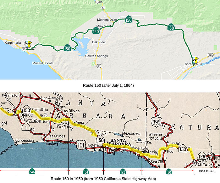
In 1963, Route 150 was defined as "Route 101 near Rincon to Route 126 near Santa Paula."
In 1968, Chapter 282 changed the origin to "Route 101 near Rincon
the Ventura-Santa Barbara county line to …"
 Pre 1964 Signage History
In 1934, Route 150 was signed along the route from Surf to Jct. Route 126 at Santa Paula, via Santa Barbara and Ojai. It consisted of the following segments:
The route was opened in 1897. Before the construction of US 101, it was part of the main highway between Los Angeles and Santa Barbara.
At some point between 1936 and 1938 a small segment of State Highway was
added that aligns with present Route 154 on San Marcos Pass Road between
US 101 and Route 192. It appears this segment of highway was a spur of LRN 80 (according to the 1959 definition) and can be seen appearing by
comparing the Santa Barbara Area on the 1936-37 State Highway Map to the
1938 Edition. This small portion of highway is important since it appears
to have ultimately been the driving force for Route 150 breaking into
several highways. Beginning in 1950 construction of Bradbury Dam in Santa
Barbara on the Santa Ynez River began and was completed by 1953. This
required that much of Route 150 between Santa Ynez and Devaul Canyon be
relocated uphill to the south of future site of Lake Cachuma. Presently
this alignment is still in use as San Marcos Pass Road on Route 154.
(Source: Gribblenation, "California State Route 150 family of highways (CA 246, CA 154, CA 192 and CA 150)", visited on 11/9/2019)
In 1961,CA 154 was first signed between Surf and US 101 in Santa Barbara.
This resulted in Route 150 being truncated to Route 154 just short of San
Marcos Pass in Santa Barbra. This change can be observed by comparing the
1961 State Highway Map to the 1962 Edition.
(Source: Gribblenation, "California State Route 150 family of highways (CA 246, CA 154, CA 192 and CA 150)", visited on 11/9/2019)
When construction of Castias Dam on the Ventura River of Ventura County
began in 1956 the original alignment of Route 150 had to be relocated. The
Castias Dam project shifted the alignment of Route 150 from the east bank
of Santa Ana Creek to the west bank. The alignment of CA 150 west of Santa
Ana Creek is still part of the modern highway on Castias Pass Road.
Castias Dam was completed by 1959 and the original alignment of Route 150
can be seen south of the Marina Cafe when Lake Castias is low.
(Source: Gribblenation, "California State Route 150 family of highways (CA 246, CA 154, CA 192 and CA 150)", visited on 11/9/2019)
 Status
In August 2011, the CTC approved $753,000 in SHOPP funding for repairs near Santa Paula, at Reeves Road and at Rafferty Ranch Road, that will restore 8.5 acres of riparian and upland habitat as required on and off site mitigation for environmental impacts on previous emergency projects at two locations. (FCO)
 Freeway
Planned as freeway in 1965; never upgraded. Not in the Freeway and Expressway system.
 Naming
 Scenic Route
[SHC 263.1] Entire route.
 Other WWW Links
 Statistics
Overall statistics for Route 150:
 Pre-1964 Legislative Route
In 1933, Chapter 767 defined the route from "[LRN 2] near Montecito to [LRN 2] W of Santa Barbara via the Coast" as part of the state highway system. In 1935, this was added to the highway code as LRN 150, with the routing:
"[LRN 2] near Montecito to [LRN 2] west of Santa Barbara via the coast."
This definition remained unchanged until the 1963 renumbering. It is present-day Route 225.
© 1996-2020 Daniel P. Faigin.
Maintained by: Daniel P. Faigin
<webmaster@cahighways.org>.
 From Route
  Route 149
 Route 151