
 California Highways:
Click here for a key to the symbols used. An explanation of acronyms may be found at the bottom of the page.
 Routing
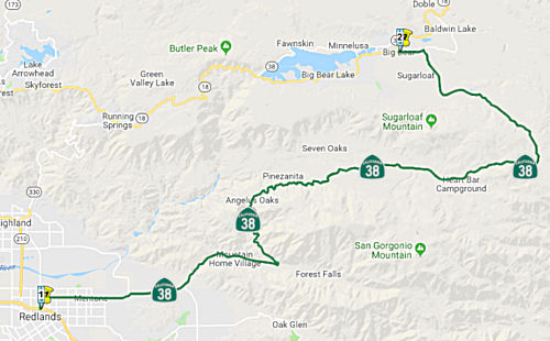 From Route 10 near Redlands to Route 18 near Baldwin Lake
via Barton Flats.
From Route 10 near Redlands to Route 18 near Baldwin Lake
via Barton Flats.
 Post 1964 Signage History
This segment remains as defined in 1963.
 Pre 1964 Signage History
Route 38 was not included in the set of state signed routes initially defined in 1934. It was signed as Route 38 sometime after 1934, and was LRN 190, defined in 1933.
A detailed history of this section prior to the adoption and construction as a state highway can be found in Tom Fearer's Gribblenation Blog “California State Route 38”, published in May 2022.
During 1910, San Bernardino County purchased all of the franchise toll
roads to Bear Valley and improved them. By 1915, San Bernardino
County completed work on what was known as the "Rim of the World
Highway." The Rim of the World Highway ascended from San Bernardino
via Waterman Canyon to Bear Valley via Lake Arrowhead. From Bear
Valley the Rim of the World Highway descended via what was the Bear Valley
& Redlands Toll Road to Redlands.
(Source: Gribblenation Blog (Tom Fearer), “California State Route 38”, May 2022)
In 1933, Chapter 767 added the routes from "[LRN 9] near San Dimas to [LRN 26] near Redlands via Highland Avenue" and "[LRN 26] near Redlands to [LRN 43] near Big Bear Lake via Barton Flats" to the highway system. In 1935, these were added to the highway code as LRN 190, with the route:
Segment 2 of this route is what became Route 38.
As of 1935, LRN 190 appears to follow an interim routing via Mountain
Home Creek Road between Mountain Home Village and Camp Angelus. From
Camp Angelus, LRN 190 appears to be aligned through Barton Flats towards
Cienega Seca Creek. The interim highway from Camp Angelus to Big
Bear Lake follows Clark's Grade to the vicinity of Pine Knot Lodge.
The older alignment of the Bear Valley & Redlands Toll Road through
the Santa Ana River Canyon displayed on the 1917 California State
Automobile Association Map existed but with a gap approaching Clark's
Grade near Deer Creek.
(Source: Gribblenation Blog (Tom Fearer), “California State Route 38”, May 2022)
Gaps in the routing remained until the 1950s. For example, LRN 190
between Camp Angelus and Bear Valley appeared as a proposed highway with a
determined routing on the 1958 Division of Highways Map. By 1961, LRN 190
was complete between US 99/US 70/LRN 26 in Redlands and Route 30/LRN 43
near Big Bear Lake. This is also when the the newly designated Route 38
starts appearing. Opening ceremonies for the completion of Route 38/LRN 190 were held on August 12, 1961, at Onyx Summit.
(Source: Gribblenation Blog (Tom Fearer), “California State Route 38”, May 2022)
 In 1958, the CHC adopted a freeway routing for the
portion of Route 38 between Barton Flats and Big Bear. It generally
followed the existing route.
In 1958, the CHC adopted a freeway routing for the
portion of Route 38 between Barton Flats and Big Bear. It generally
followed the existing route.
(Source: Redland Daily Facts, 6/20/1957 via Joel Windmiller,
1/27/2023)
Note that Route 38 [LRN 190] was not the main route into Big Bear. That routing was along signed Route 18, which was LRN 43. LRN 43 was defined in 1917 "...beginning at a point in Waterman Cyn at the termination of the pavement of the San Bernardino County highway system, thence following the meanderings of the road known as the "Crest Drive" into Bear Valley, ending at a point directly opposite the most easterly point of Bear Lake." The 1919 Third Bond Issue extended the route from Deep Creek to Metcalf Creek, specifically "Deep Creek easterly via Bear Valley Dam to the county road at Metcalf Creek in the Angeles National Forest (Arrowbear to the Eastern End of Big Bear Lake)." In 1931, LRN 43 was extended further to the S, down Waterman Canyon via Santa Ana Canyon to Newport Beach. Lastly, in 1933, the route was extended further, from [LRN 31] from Victorville to [LRN 43] near Big Bear Lake via Baldwin Lake. It was also extended to complete the circle around Big Bear Lake. Portions of LRN 43 up the canyon were cosigned as Route 30/Route 18, and the Route 30 designation was also given to the S side of the lake. In 1964, the cosigning was eliminated, the S side of the lake became Route 18, and the N side of the lake became Route 38. The former Route 30 N of Highland was renumbered as Route 330, and ends where it meets Route 18.
 Status
Thurman Flats (~ SBD R10.304) to Glass Road (~ SBD 26.522)
In October 2020, it was reported that Caltrans has
initiated a $3.5 million director’s order to begin an emergency
project to repair damages to Route 38 as the result of El Dorado wildfire.
The project limits are from Thurman Flats to Glass Road. The project has
been awarded to Riverside Construction Company, Inc. and started on
Friday, Oct. 2, 2020. The work will stabilize slopes, remove debris and
hazardous/burned trees, excavate and clear culverts and inlet basins
(post-fire debris flow basins), replace debris racks and include rock
slope scaling. The schedule is 7 a.m. to 5 p.m. Monday through Friday, and
it will require traffic control until the project is complete. The project
is expected to be complete by late spring 2021, contingent on weather and
any further damage to the facility.
(Source: Highland Community News, 10/8/2020)
 Naming
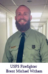 The portion of Route 38 between the Mill Creek Bridge #54-0346
(SBD 9.601) and the Mt. Home Creek Bridge #54-1046 (SBD R12.279) near the
community of Mentone in the County of San Bernardino as the United
States Forest Service Firefighter Brent Michael Witham Memorial Highway.
It was named in memory of United States Forest Service Firefighter Brent
Michael Witham, who lost his life in the line of duty when he was struck
and killed by a falling tree on Wednesday, August 2, 2017, while working
on the Lolo Peak Fire in western Montana. Brent Michael Witham was born in
July 1988, in Redlands, California. He was a member of the Vista Grande
Hotshot crew based in the San Bernardino National Forest of California.
Hotshot crews are firefighters trained specifically for wildfire
suppression. Brent loved the challenges of being part of this elite group
of firefighters, and looked forward to going to work every day and worked
hard to be a good role model, leader, and firefighter. Brent was a member
of one of 113 hotshot crews in the United States tasked with the serious
job of either hiking or being airdropped to remote areas of the wilderness
to fight fires, usually with just the equipment they can carry. Brent
began his firefighting career in 2011 as a member of the Tahquitz Handcrew
based in Riverside, California, and was assigned to Station 56 near
Mountain Center, California, in the San Jacinto Mountains in 2013. At the
time of his passing, Brent had served six years as a hardworking
professional who was eager to learn and be the best that he could be,
according to Jody Noiron, San Bernardino National Forest Supervisor. Named
by Senate Concurrent Resolution 32 (SCR 32), Resolution Chapter 138,
8/28/19)
The portion of Route 38 between the Mill Creek Bridge #54-0346
(SBD 9.601) and the Mt. Home Creek Bridge #54-1046 (SBD R12.279) near the
community of Mentone in the County of San Bernardino as the United
States Forest Service Firefighter Brent Michael Witham Memorial Highway.
It was named in memory of United States Forest Service Firefighter Brent
Michael Witham, who lost his life in the line of duty when he was struck
and killed by a falling tree on Wednesday, August 2, 2017, while working
on the Lolo Peak Fire in western Montana. Brent Michael Witham was born in
July 1988, in Redlands, California. He was a member of the Vista Grande
Hotshot crew based in the San Bernardino National Forest of California.
Hotshot crews are firefighters trained specifically for wildfire
suppression. Brent loved the challenges of being part of this elite group
of firefighters, and looked forward to going to work every day and worked
hard to be a good role model, leader, and firefighter. Brent was a member
of one of 113 hotshot crews in the United States tasked with the serious
job of either hiking or being airdropped to remote areas of the wilderness
to fight fires, usually with just the equipment they can carry. Brent
began his firefighting career in 2011 as a member of the Tahquitz Handcrew
based in Riverside, California, and was assigned to Station 56 near
Mountain Center, California, in the San Jacinto Mountains in 2013. At the
time of his passing, Brent had served six years as a hardworking
professional who was eager to learn and be the best that he could be,
according to Jody Noiron, San Bernardino National Forest Supervisor. Named
by Senate Concurrent Resolution 32 (SCR 32), Resolution Chapter 138,
8/28/19)
(Image source: Highland News)
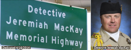 The portion of Route 38
between PM SBD 24.00 to PM SBD 29.00, inclusive, in San Bernardino County
is officially named the "Detective Jeremiah MacKay Memorial Highway."
It was named on 09/27/13 by ACR 68, Res. Chapter 142, Statutes of 2013. It
was named in memory of Detective Jeremiah MacKay. MacKay was born in June
1977 in San Bernardino. Mr. MacKay grew up with his younger sister in Lake
Arrowhead, where he developed a passion for mountain recreation. At the
age of four he climbed the highest peak in southern California,
11,503-foot Mount San Gorgonio. Mr. MacKay attended Calvary Chapel
Christian School in Twin Peaks, and Mary P. Jenck Intermediate School and
Rim of the World High School, both in Lake Arrowhead. Throughout his
adolescence, Mr. MacKay enjoyed being part of a youth group at Church of
the Woods in Lake Arrowhead, and loved participating in sports, including
football, tennis, and skiing. Mr. MacKay continued to spend time in the
mountains as a young man, working as a ski and snowboard instructor at the
Snow Valley Ski Resort in Running Springs, and as lake patrol for the
Arrowhead Lake Association in Lake Arrowhead. Mr. MacKay began his career
in public service when he joined the San Bernardino County Sheriff’s
Department as a member of Academy Class 131. He graduated from the program
and became a Deputy Sheriff on June 4, 1998, his 21st birthday. As a
deputy, Mr. MacKay was assigned to the Central Detention Center, Central
Station, and Sheriff Training Facility, all in San Bernardino, and Twin
Peaks station, in Twin Peaks. He was promoted to the rank of detective and
served in that capacity at stations in Twin Peaks, Big Bear, and Yucaipa,
with the radio call sign of 14.D.2. As part of the San Bernardino County
Sheriff’s Department, Detective MacKay earned five California
Highway Patrol 10851 Awards and three Commander’s Awards. Detective
MacKay was chosen to be a member of the San Bernardino County
Sheriff’s Department Honor Guard, and lived by the three cardinal
principles of the Sheriff’s Department: honor, pride, and tradition.
Detective MacKay married in November 2011. Detective MacKay took pride in
his Scottish heritage and enjoyed playing the bagpipes. He was a member of
the Inland Empire Emerald Society for six years, and ultimately became the
organization’s sergeant at arms. On February 12, 2013, at the age of
35, Detective MacKay was shot and killed by Christopher Dorner during the
manhunt for the rogue ex-Los Angeles Police Department officer. To honor
Detective MacKay’s memory, the 14.D.2 Prayer Project has been
established to encourage prayer for the safety of first responders.
The portion of Route 38
between PM SBD 24.00 to PM SBD 29.00, inclusive, in San Bernardino County
is officially named the "Detective Jeremiah MacKay Memorial Highway."
It was named on 09/27/13 by ACR 68, Res. Chapter 142, Statutes of 2013. It
was named in memory of Detective Jeremiah MacKay. MacKay was born in June
1977 in San Bernardino. Mr. MacKay grew up with his younger sister in Lake
Arrowhead, where he developed a passion for mountain recreation. At the
age of four he climbed the highest peak in southern California,
11,503-foot Mount San Gorgonio. Mr. MacKay attended Calvary Chapel
Christian School in Twin Peaks, and Mary P. Jenck Intermediate School and
Rim of the World High School, both in Lake Arrowhead. Throughout his
adolescence, Mr. MacKay enjoyed being part of a youth group at Church of
the Woods in Lake Arrowhead, and loved participating in sports, including
football, tennis, and skiing. Mr. MacKay continued to spend time in the
mountains as a young man, working as a ski and snowboard instructor at the
Snow Valley Ski Resort in Running Springs, and as lake patrol for the
Arrowhead Lake Association in Lake Arrowhead. Mr. MacKay began his career
in public service when he joined the San Bernardino County Sheriff’s
Department as a member of Academy Class 131. He graduated from the program
and became a Deputy Sheriff on June 4, 1998, his 21st birthday. As a
deputy, Mr. MacKay was assigned to the Central Detention Center, Central
Station, and Sheriff Training Facility, all in San Bernardino, and Twin
Peaks station, in Twin Peaks. He was promoted to the rank of detective and
served in that capacity at stations in Twin Peaks, Big Bear, and Yucaipa,
with the radio call sign of 14.D.2. As part of the San Bernardino County
Sheriff’s Department, Detective MacKay earned five California
Highway Patrol 10851 Awards and three Commander’s Awards. Detective
MacKay was chosen to be a member of the San Bernardino County
Sheriff’s Department Honor Guard, and lived by the three cardinal
principles of the Sheriff’s Department: honor, pride, and tradition.
Detective MacKay married in November 2011. Detective MacKay took pride in
his Scottish heritage and enjoyed playing the bagpipes. He was a member of
the Inland Empire Emerald Society for six years, and ultimately became the
organization’s sergeant at arms. On February 12, 2013, at the age of
35, Detective MacKay was shot and killed by Christopher Dorner during the
manhunt for the rogue ex-Los Angeles Police Department officer. To honor
Detective MacKay’s memory, the 14.D.2 Prayer Project has been
established to encourage prayer for the safety of first responders.
(Image sources: ABC7; Officer Down Memorial Page)
 Freeway
[SHC 253.3] Entire portion. Added to the Freeway and Expressway system in 1959.
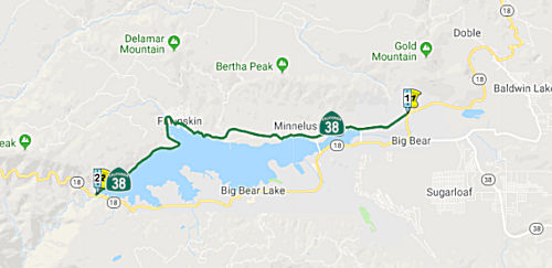 From Route 18 near Baldwin Lake along the north side of Big
Bear Lake to Route 18 near the west end of Big Bear Lake.
From Route 18 near Baldwin Lake along the north side of Big
Bear Lake to Route 18 near the west end of Big Bear Lake.
Post 1964 Signage HistoryThis segment remains as defined in 1963.
Note that a big numbering switch occurred in 1964. Prior to 1964, Route 18 ran N from San Bernardino. At Running Springs, it joined with Route 30 (now Route 330) up from Highland, and continued cosigned Route 18/Route 30 to the W end of Big Bear Lake. At this point, Route 30 ran along the S edge of the lake, and Route 18 ran along the N end. In 1964, Route 18 was rerouted to the S side of Big Bear Lake (replacing what had been signed as Route 30). The cosigning that existed between the W end of Big Bear Lake and the Route 30 (now Route 330)/Route 18 junction was eliminated, and the route was just signed as Route 18. The old Route 18 routing on the N side of the lake was signed as Route 38.
Pre 1964 Signage HistoryThis was originally part of Route 18 (from the west end of Big Bear Lake to Big Bear City), and was LRN 43. The route that would become LRN 43 was first defined in 1917 by Chapter 697, which called for inclusion in the state highway system of the route "...beginning at a point in Waterman Cyn at the termination of the pavement of the San Bernardino County highway system, thence following the meanderings of the road known as the "Crest Drive" into Bear Valley, ending at a point directly opposite the most easterly point of Bear Lake." The 1919 Third Bond Issue extended the route from Deep Creek to Metcalf Creek, specifically "Deep Creek easterly via Bear Valley Dam to the county road at Metcalf Creek in the Angeles National Forest (Arrowbear to the Eastern End of Big Bear Lake)." This ran along the N side of the lake, and was signed as Route 18.
In 1933, the route was extended further, from [LRN 31] from Victorville to [LRN 43] near Big Bear Lake via Baldwin Lake. It was also extended to complete the circle around Big Bear Lake. Thus, the route was codified in the 1935 highway code as: "Newport Beach to [LRN 31] near Victorville, via Santa Ana Canyon, San Bernardino, Waterman Canyon, "Crest Drive" into Bear Valley, Big Bear Lake and Baldwin Lake. [LRN 43] includes a highway around Big Bear Lake."
In 1964, some route renumbering and simplification occurred, and the N side of the lake was resigned as Route 38, with Route 18 being moved to the S side of the lake.
Naming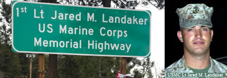 The portion of Route 38 between PM SBD 49.530 and SBD
59.396 in San Bernardino County is named the "Lieutenant Jared M.
Landaker Memorial Highway" This segment was named in memory of USMC
Lieutenant Jared M. Landaker, who made the ultimate sacrifice for his
country when, on February 7, 2007, he gave his life while serving in Iraq
in the United States Marine Corps. Lieutenant Landaker was born in Madera,
California, on May 3, 1981. Due to a possible complication at Lieutenant
Landaker's birth, doctors warned his parents that their child might be
mentally challenged. The doctors encouraged surgery, an option that Joe
and Laura Landaker refused. Although smaller in size than most boys his
age, Lieutenant Landaker proved the doctors wrong by excelling in both
academics and sports. As a young man, Lieutenant Landaker enjoyed skiing,
snowboarding, and playing baseball and football. While attending Big Bear
High School, Lieutenant Landaker played varsity baseball, served as the
quarterback on the varsity football team, was an all-CIF defensive back,
and was inducted into the player hall of fame. The head football coach at
Big Bear High School, Dave Griffith, considered Lieutenant Landaker not
only a standout football player but also a standout person and a role
model to kids. Joe Bradley, a physics teacher and baseball coach at Big
Bear High School, also held Lieutenant Landaker in high regard, stating
that he had never coached a kid with more heart or courage. In homage to
Lieutenant Landaker's athletic legacy at Big Bear High School, his jersey,
number 15, was recently retired and an award is to be made in his honor.
After graduating from high school, Lieutenant Landaker studied physics at
the University of La Verne. Following the events of September 11, 2001,
Lieutenant Landaker felt the need to do his part and decided to join the
United States Marine Corps. He proceeded to attend Officer Candidate
School, The Basic School, and flight school. Ranking in the top 5% during
flight training, he was awarded the privilege of selecting an aircraft.
Desiring to be a part of the community, he chose the CH-46 Sea Knight
helicopter, an aircraft involving some of the most noble assignments in
the military. Within just seven months, Lieutenant Landaker achieved the
status of Helicopter Aircraft Commander, a status that typically takes at
least one year to achieve. Lieutenant Landaker received a commission as
second lieutenant on September 7, 2003, followed by a commission of first
lieutenant on September 7, 2005. He served as a first lieutenant with the
Marine Medium Helicopter Squadron 364, nicknamed "the Purple Foxes." As a
medevac pilot, he airlifted wounded marines and citizens out of dangerous
combat zones in Anbar province in Iraq. On February 7, 2007, just one week
before his scheduled return home, Lieutenant Landaker gave his life while
flying a CH-46 Sea Knight helicopter that was shot down over Anbar
province. In recognition of his service in the military, Lieutenant
Landaker received a purple heart, a National Defense Service Medal, an
Iraqi Campaign Medal, a Global War on Terrorism Service Medal, a Sea
Service Deployment Ribbon, and a Navy and Marine Corps Achievement Medal.
Named by Assembly Concurrent Resolution (ACR) 59, Resolution Chapter 115,
on 9/10/2007.
The portion of Route 38 between PM SBD 49.530 and SBD
59.396 in San Bernardino County is named the "Lieutenant Jared M.
Landaker Memorial Highway" This segment was named in memory of USMC
Lieutenant Jared M. Landaker, who made the ultimate sacrifice for his
country when, on February 7, 2007, he gave his life while serving in Iraq
in the United States Marine Corps. Lieutenant Landaker was born in Madera,
California, on May 3, 1981. Due to a possible complication at Lieutenant
Landaker's birth, doctors warned his parents that their child might be
mentally challenged. The doctors encouraged surgery, an option that Joe
and Laura Landaker refused. Although smaller in size than most boys his
age, Lieutenant Landaker proved the doctors wrong by excelling in both
academics and sports. As a young man, Lieutenant Landaker enjoyed skiing,
snowboarding, and playing baseball and football. While attending Big Bear
High School, Lieutenant Landaker played varsity baseball, served as the
quarterback on the varsity football team, was an all-CIF defensive back,
and was inducted into the player hall of fame. The head football coach at
Big Bear High School, Dave Griffith, considered Lieutenant Landaker not
only a standout football player but also a standout person and a role
model to kids. Joe Bradley, a physics teacher and baseball coach at Big
Bear High School, also held Lieutenant Landaker in high regard, stating
that he had never coached a kid with more heart or courage. In homage to
Lieutenant Landaker's athletic legacy at Big Bear High School, his jersey,
number 15, was recently retired and an award is to be made in his honor.
After graduating from high school, Lieutenant Landaker studied physics at
the University of La Verne. Following the events of September 11, 2001,
Lieutenant Landaker felt the need to do his part and decided to join the
United States Marine Corps. He proceeded to attend Officer Candidate
School, The Basic School, and flight school. Ranking in the top 5% during
flight training, he was awarded the privilege of selecting an aircraft.
Desiring to be a part of the community, he chose the CH-46 Sea Knight
helicopter, an aircraft involving some of the most noble assignments in
the military. Within just seven months, Lieutenant Landaker achieved the
status of Helicopter Aircraft Commander, a status that typically takes at
least one year to achieve. Lieutenant Landaker received a commission as
second lieutenant on September 7, 2003, followed by a commission of first
lieutenant on September 7, 2005. He served as a first lieutenant with the
Marine Medium Helicopter Squadron 364, nicknamed "the Purple Foxes." As a
medevac pilot, he airlifted wounded marines and citizens out of dangerous
combat zones in Anbar province in Iraq. On February 7, 2007, just one week
before his scheduled return home, Lieutenant Landaker gave his life while
flying a CH-46 Sea Knight helicopter that was shot down over Anbar
province. In recognition of his service in the military, Lieutenant
Landaker received a purple heart, a National Defense Service Medal, an
Iraqi Campaign Medal, a Global War on Terrorism Service Medal, a Sea
Service Deployment Ribbon, and a Navy and Marine Corps Achievement Medal.
Named by Assembly Concurrent Resolution (ACR) 59, Resolution Chapter 115,
on 9/10/2007.
(Image source: Jolygram, Seven Stars Foundation)
 Scenic Route
[SHC 263.1] Entire route.
 Interregional Route
[SHC 164.12] Between the east urban limits of San Bernardino-Riverside and Route 18 west of Big Bear Lake.
 Other WWW Links
 Statistics
Overall statistics for Route 38:
 Pre-1964 Legislative Route
The route that would become LRN 38 was first defined in 1911 by Chapter 158 which called for "...a state highway from a point on the Lake Tahoe state wagon road, at or near Myers Station... thence past Tallac, Emerald Bay, to McKinney's in Placer County....".
In 1915, Chapter 203 effectively extended the route by calling for a state highway along "...the wagon road extending along the W side of Lake Tahoe, from McKinney's in El Dorado Cty to Tahoe City, thence along the Truckee River to Truckee, and thence in a W-ly direction to Donner Lake in Nevada Cty, connecting with the present state highway from Emigrant Gap".
In 1919, Chapter 66 called for the state highway system to include “A certain highway in Nevada and Sierra counties, running as follows: From a point in the town of Truckee where the present state highway branches at the subway under the Southern Pacific tracks going toward Lake Tahoe, continuing through the town of Truckee, crossing Prosser Creek and over what is known as the "Dog Valley Grade" as far as the state line about 1 mi NW of Verdi, Nevada...”
The 1919 Third Highway Bonds also provided funding for the extension from Tahoe City to Truckee.
In 1923, Chapter 100 amended the 1919 definition as follows: “A
certain highway in Nevada and Sierra counties, running
substantially described as follows: From a point in the
town of Truckee where the present state highway branches at the subway
under the Southern Pacific tracks going toward Lake Tahoe, continuing
through the town of Truckee, crossing Prosser Creek and over what
is known as the "Dog Valley Grade" as far as the state line about 1 mi
NW of Verdi, Nevada..." and by the most practicable route
to the Nevada State Line at or near Verdi, Nevada”
By 1935, the route was codified into the highway code as:
[LRN 11] near Meyer's Station to the Nevada State Line near Verdi, Nevada, via Tallac, Emerald Bay, McKinney's, Tahoe City, the Truckee River, Truckee, and Truckee River Canyon.
This was primary state highway from Truckee to the Nevada State Line.
In 1939, Chapter 473 changed "Meyer's Station" to "May's Junction". No further changes in the route were made until the 1963 renumbering.
This route was signed as follows:
© 1996-2020 Daniel P. Faigin.
Maintained by: Daniel P. Faigin
<webmaster@cahighways.org>.
 Route 37
 Route 39