
 California Highways:
Click here for a key to the symbols used. An explanation of acronyms may be found at the bottom of the page.
 Routing
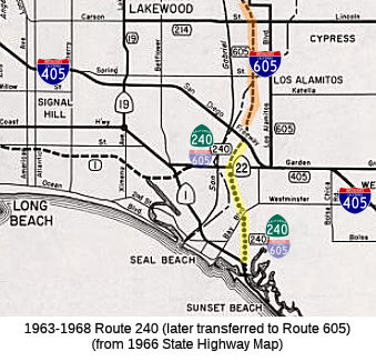 No current routing.
 Post 1964 Signage History
 ▸In 1963, Route 240 was defined as “Route 1 near Seal
Beach to Route 405.”
During the 1964 State Highway Renumbering, Route 35 was repurposed over
what was Sign Route 5 in the Santa Cruz Mountains. The entirety of
LRN 170 and the San Gabriel River Freeway was broken up into three
designations. Chargeable I-605 was from "Route 405 to Route 10 near
the San Gabriel River." The planned San Gabriel River Freeway south
of I-405 to Route 1 became Route 240. The planned San Gabriel River
Freeway north of I-10 to I-210 and the Foothill Freeway became Route 243. Until the new I-605 was completed, the previous surface route
of the original Sign Route 35 was temporarily designated as LRN 605.
In 1964, construction of the Route 240 portion of the San Gabriel River
Freeway to Route 22 was partially financed, with a planned completion in
late 1966.
(Source: Gribblenation Blog (Tom Fearer), "Former California State Route 240", 4/5/2023)
▸In 1968, Chapter 282 repealed the definition of Route 240, transferring the routing to Route 605.
 Pre 1964 Signage History
The 1964-1968 routing was part of LRN 170, defined in 1933. LRN 170 was defined as "LRN 179 near Seal Springs via Santa Fe Springs to LRN 26 near West Covina."
In 1934, Sign Route 35 was assigned concurrent with LRN 170 between US 99/US 60/US 70/LRN 26 in West Covina and Sign Route 22/LRN 179 near Seal
Beach. This corridor was adopted as part of the San Gabriel River
Freeway on 12/15/1954. This corridor was approved as chargeable
Interstate on 9/15/1955, and would become I-605.
(Source: Gribblenation Blog (Tom Fearer), "Former California State Route 240", 4/5/2023)
In 1957, LRN 170 was extended south to US 101A/LRN 60 near Seal
Beach. The segment of LRN 170 south of Route 22/LRN 179 was not
included in the chargeable Interstate corridor of the San Gabriel River
Freeway. There was no determined routing south of Route 22/LRN 179.
(Source: Gribblenation Blog (Tom Fearer), "Former California State Route 240", 4/5/2023)
 Other WWW Links
 Pre-1964 Legislative Route
In 1957, Chapter 24 defined LRN 240 to be “[LRN 4] near Glendale to [LRN 26] near the east boundary of Los Angeles County on a route to be selected by the California Highway Commission, which route may include all or portions of any existing state highway route or routes”. The urgency clause noted this was related to a circumferential freeway around Los Angeles.
This route runs from I-5 near Glendale to I-10 near the east boundary of Los Angeles County. This LRN was used for the future freeway routings of Route 134 between present-day I-5 and I-210, and I-210 between Route 134 and Route 57, and Route 57 between I-210 and I-10. It duplicated the paths of LRN 161 and LRN 9. The portion between the post-1998 Route 210/Route 57 junction and I-10 was originally also I-210.
Between San Dimas and US 60/US 70/US 99, LRN 240 was to have been designated Route 71 (the signed Route 71 at this time ran to the east along LRN 19).
© 1996-2020 Daniel P. Faigin.
Maintained by: Daniel P. Faigin
<webmaster@cahighways.org>.
 Route 239
 Route 241