
 California Highways:
Click here for a key to the symbols used. An explanation of acronyms may be found at the bottom of the page.
 Routing
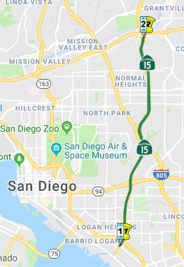 From Route 5 in San Diego to Route 8.
 Post 1964 Signage History
 This segment was added to Route 15 in 1969 by Chapter 294; it was
previously Route 103. See below for the pre-1964
routing of Route 15.
This segment was added to Route 15 in 1969 by Chapter 294; it was
previously Route 103. See below for the pre-1964
routing of Route 15.
In late 1963, the CTC adopted 6.4 miles of freeway along Route 103 near
US 80/I-8 north to US 395. The adopted freeway corridor followed the
existing routing of Route 103 along Ward Road and Murphy Canyon Road.
(Source: Gribblenation Blog (Tom Fearer), "California State Route 15", 9/9/2023)
I-15 was approved to be extended south of I-10 in San Bernardino to I-8
in San Diego as a chargeable corridor by the Federal Highway
Administration during December 1968. The newly extended I-15 was to
follow the corridor of Route 103 south of US 395 to I-8. In 1969, Route 103 was renumbered as Route 15. On October 24, 1984, Caltrans submitted a
request to the American Association of State Highway Transportation
Officials (AASHTO) to extend I-15 from I-8 to I-5 via Route 15.
Caltrans noted the Federal Highway Administration had already given
approval to extend I-15 south to I-5 as a non-chargeable corridor.
The request was granted by AASHTO December 8, 1984. AASHTO's
approval to extend I-15 did not carry a stipulation that Route 15 be
upgraded to Interstate standards.
(Source: Gribblenation Blog (Tom Fearer), "California State Route 15", 9/9/2023)
The segment between I-8 and I-805 (the 40th Street segment) is in the process of conversion to freeway standards. As soon as this conversion to freeway is completed, this will be resigned as I-15. Presently, it is 139(b) non-chargable interstate mileage.
The segment between I-805 and I-5 is already freeway standard. Route 15 ends just south of the I-5 interchange at 32nd Street and Harbor Drive, in the community of Barrio Logan in San Diego. The portion connecting Harbor Drive is a ramp and not part of the route itself.
During the early 2000s Route 15 north of I-805 to I-8 was fully brought
up to freeway standards and largely replaced 40th Street.
During 2001, Teralta Park was constructed over Route 15 as the corridor
was being converted to freeway. As of 2023, Route 15 between I-5 and
I-805 is ineligible to become Interstate 15 for the following reasons:
(Source: Gribblenation Blog (Tom Fearer), "California State Route 15", 9/9/2023)
 Pre 1964 Signage History
In 1959, Chapter 1062 defined LRN 283 as:
This was not assigned a sign route at the time of creation.
In 1960, it was noted that Segment 2 of LRN 283 did not have a formal
route adoption by the California Highway Commission between US 101/LRN 2
(Future I-5) and US 395/LRN 77 (Future I-15). The city of San Diego
had adopted Wabash Boulevard, 40th Street and Ward Road as
major highway corridor following World War II. The Wabash
Boulevard/Route 94 was constructed by the city of San Diego prior to
becoming part of LRN 283. A portion of Ward Road between Monroe
Street to US 80 (Future I-8) was nearing completion as a four-lane
expressway. The segment north of US 80 to US 395 was under
construction and financed. Continued development of LRN 283 was to
be a cooperative effort between the Division of Highways, city of San
Diego and Federal Aid Programs. In 1962, the California Highway Commission
adopted a 2.8-mile freeway routing of LRN 283 from US 101/LRN 2 to Nile
Street. In 1964, the "Great Renumbering" assigned LRN 283 the
designation Route 103.
(Source: Gribblenation Blog (Tom Fearer), "California State Route 15", 9/9/2023)
In 1969, Route 103 (LRN 283, defined in 1959) was renumbered as Route 15, and a former portion of US 395 was renumbered as Route 163. The Route 103 number was released for reuse; it was reused in the Los Angeles are in 1983.
(Source: Gribblenation Blog (Tom Fearer), "California State Route 15", 9/9/2023)
 Status
Route 15 cannot be currently signed as Interstate 15 because Route 15 is still not Interstate-standard between I-5 and Route 94 (~ SD R0.028L to SD 2.152), especially near Market Street. There are some on/off ramps that do not have adequate deceleration/acceleration lanes. This is currently being reconstructed. Note that Route 15/40th Street Fwy was not funded using conventional Interstate Highway funding. The primary concern is the Route 15/Route 94 interchange (~ SD 2.152). The blind ramps, left exits, and narrowing of Route 15 to two lanes each way make this a substandard interchange. Howerver, reconstruction of this interchange to Interstate standards may occur as soon as 2006, pending funding identification and acceleration of this reconstruction in the planning documents. This is also related to the Route 94 corridor study, which is likely to result in additional improvements to that freeway corridor as well.
Harbor Drive 2.0 Project (11-SD-15 ~ R0.0/R0.232)
In October 2022, the CTC received notice that Caltrans
will request that the CTC approve a program amendment at the next
scheduled Commission meeting. The Department proposes to program
$5,000,000 of "The Infrastructure Investment and Jobs Act (IIJA)" Surface
Transportation Block Grant Program (STBGP) – Coordinated Border
Infrastructure Program (CBI) funds to the new I-5/Route 15/Harbor Drive
2.0 project (PPNO 11-1447; EA 43131), in San Diego County.This Project is
located on Harbor Drive from Imperial Avenue in the City of San Diego to
Mile of Cars Way in the City of National City with connecting arterials to
the Department’s right-of-way with the I-5 and Route 15. This
interjurisdictional project encompasses San Diego's Working Waterfront
extending from the Unified Port of San Diego's (Port) Tenth Avenue Marine
Terminal to the National City Marine Terminals. This includes the Naval
Base of San Diego, private shipyards (Shipyards), industry and hospitality
services, and Assembly Bill 617 identified Portside Environmental Justice
(EJ) neighborhoods of Barrio Logan and National City. Harbor Drive is a
4-lane major arterial roadway adjoining the San Diego Bay from Point Loma
to National City. Harbor Drive currently experiences high levels of
congestion that slow down Port and naval operations and produce downstream
impacts on Portside EJ Neighborhoods. Currently, neither Harbor Drive nor
it’s connecting arterials have intelligent transportation
technologies and signal prioritization equipment installed. This has
resulted in most intersections failing to clear vehicles during peak hour
traffic. In addition, significant queuing occurs at the Naval Base of San
Diego security gates extending into general-purpose travel lanes thus
constraining movement between the Marine terminals, I-5, and Route 15. The
purpose of the project is to develop a connected, sustainable freight
corridor to enable efficient movement of goods and people between the
Working Waterfront, I-5 and Route 15 and install Intelligent
Transportation Systems technologies to improve access and circulation to
I-5 and Route 15, Port marine terminals, Shipyards, and Naval Base
San Diego gates; which will manage truck travel on designated routes
and to expand transportation mobility options for the Working Waterfront.
(Source: October 2022 CTC Agenda, Agenda Item
2.1b.(1))
In December 2022, the CTC approved the following STIP
amendment that was noticed at the October 2022 CTC meeting: 11-SD-5
R9.840/R14.700. PPNO 11-1447; EA 43131. I-5/SR-15/Harbor Drive 2.0.
I-5 In San Diego County on Harbor Drive from Imperial Avenue in the City
of San Diego to Mile of Cars Way in the City of National City with
connecting arterials to Caltrans right-of-way with the I-5 and Route 15.
This project proposes to introduce connected all-day and off-peak
dedicated truck lanes and Intelligent Transportation Systems technologies
along Harbor Drive and connecting arterials to I-5 and Route 15 in San
Diego and National City. Additional improvements include upgraded and new
traffic signals, freight signal priority and truck queue jumps, wayfinding
gantries, pedestrian and bicycle infrastructure upgrades, and supportive
infrastructure for the deployment of alternative fuel and zero-emission
vehicle charging and pilot innovations. The CTC action programmed
$5,000,000 of Surface Transportation Block Grant Program (STBGP) –
Coordinated Border Infrastructure Program (CBI) funds.
(Source: December 2022 CTC Agenda, Agenda Item
2.1a.(2))
In June 2023, the adoption of the 2022 Trade Corridor
Enhancement Program included the following description of a program: The
I-5, Route 15, and Harbor Drive 2.0 Project improves freight throughput of
about 1,600 more trucks per year in a key freight location by constructing
all-day connected truck-only lanes and off-peak dedicated flex lanes,
queue jumps, freight signal priority, and other Intelligent Transportation
System technologies to separate trucks from passenger traffic. It includes
zero-emission commercial vehicle charging stations for freight trucks. The
project also includes sidewalks and bike lanes addressing community
concerns by separating freight traffic from passenger traffic. The Vesta
Street Bridge component allows freight trucks to cross the Naval Base San
Diego without going on the local roads. The recommended Trade Corridor
Enhancement Program funds are for the Right-of-Way and Plans,
Specifications, and Estimate phases of this project.
(Source: June 2023 CTC Agenda, Agenda Item 4.5)
In July 2023, it was reported that the CTC allocated
$18.5 million to fund the I-5, Route 15 and Harbor Drive 2.0 Project in
the city of San Diego, which will improve freight throughput of about
1,600 more trucks per year by constructing all-day connected truck-only
lanes and off-peak dedicated flex lanes, and other improvements to
separate trucks from passenger traffic.
(Source: Construction Equipment Guide, 7/24/2023)
The SAFETEA-LU act, enacted in August 2005 as the reauthorization of TEA-21, provided the following expenditures on or near this route:
In September 2011, the CTC approved $5,883,000 for a project in the city of San Diego, from north of Main Street to south of Landis Street pedestrian overcrossing (~ SD 0.405 to ~ SD M4.406)) to rehabilitate 23 roadway lane miles to extend pavement service life and improve ride quality.
In May 2005, the CTC considered relinquishment of right of way in the City of San Diego, along 36th Street, between Imperial Avenue and K Street, consisting of a reconstructed and relocated city street (~ SD 1.501 to SD 1.648). In July 2005, the CTC considered relinquishment of right of way in the City of San Diego, between Dwight Street and 0.05 mile north of Adams Avenue, consisting of superseded highway right of way, reconstructed and relocated city streets, frontage roads and cul-de-sacs.
Caltrans currently has a project to upgrade this segment to an eight-lane freeway basically following the 40th Street alignment through the Mid-City community of the City of San Diego. This is now open to traffic. From Landis Street (~ SD M4.406) to Adams Avenue (~ SD M5.594), the freeway will generally be located between 40th Street and Central Avenue/Terrace Drive about 25 feet below ground. All but three city streets - Polk and Monroe avenues, and Landis Street - crossing 40th Street will stay open. Bridges will be constructed at Wightman Street, University Avenue, Orange Avenue, El Cajon Boulevard and Meade Avenue. Traffic will be able to get on and off the freeway within this segment of Route 15 through interchanges at University Avenue, El Cajon Boulevard and Adams Avenue. One city block of the freeway, between Polk and Orange avenues, will be covered with a community park. Pedestrian bridges will be provided at Monroe Avenue and near Landis Street. Pedestrians along Polk Street may cross through the park on the block of freeway cover.
The small segment in San Diego at PM SD 4.1 was up for relinquishment in September 2002.
In February 2010, the CTC approved relinquishement of right of way in the city of San Diego along Route 15 on 40th Street between Madison and Adams Avenues, (~ SD M5.436 to SD M5.582) consisting of a relocated and reconstructed city street.
In March 2016, it was reported that workers constructing a raised bikeway
along I-15 connecting Kensington and Mission Valley (~ SD M5.824 to SD
R6.625) discovered a small whale bone sticking out from a sandstone bluff.
Caltrans called San Diego Natural History Museum paleontologist Rodney
Hubscher to the site. He said the small fragment is from the fin of a
whale that swam through the area 3.5 million years ago. Bands of mussel
and scallop shells stripe the hillside higher up. Hubscher said much of
the region was underwater before the earth cooled, lowering sea levels,
and shifts in tectonic plates jutted landmasses.Lauren Kemp of Caltrans
works with the Nat to preserve fossils found at job sites throughout San
Diego and Imperial Counties. Some of the findings will go in the Nat's
collection. But Kemp said Caltrans intends to preserve the hillside,
making a quick bike trip a trip through history, too. The second phase of
the project will extend the bike route south to City Heights. The first
phase is expected to open in late 2017.
(Source: KPBS, 3/16/2016)
 Naming
The segment between Route 5 and Route 805 (~ SD R0.028L to SD R3.436) is called "Wabash". It was named by location, because the freeway approximates the old route of Wabash Boulevard.
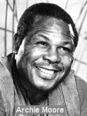 The section of this route between the Ocean View Boulevard exit and the Home Avenue exit (~ SD R0.601 to SD 2.118) is named
the "Archie Moore Memorial Freeway". Archie Moore was a legendary
boxer whose outstanding career endured through four decades and a record
143 knockouts and who won the light-heavyweight championship when he was
nearly 39 years old. After winning his title, he defined it nine times. He
served as a trainer in the 1976 Olympics in Montreal and was elected to
the Boxing Hall of Fame. He served in the Dept. of Housing and Urban
Development during the Reagan administration. He lived in a home on E
street in San Diego where he operated a restaurant known as Archie Moore's
Chicken Shack. He also ran the "Any Boy Can" program that taught at-risk
youth how to box, and about competition, sportsmanship, self-reliance,
self-discipline, confidence, and courage. Named by Assembly Concurrent
Resolution 90, Chapter 141, on September 27, 1999.
The section of this route between the Ocean View Boulevard exit and the Home Avenue exit (~ SD R0.601 to SD 2.118) is named
the "Archie Moore Memorial Freeway". Archie Moore was a legendary
boxer whose outstanding career endured through four decades and a record
143 knockouts and who won the light-heavyweight championship when he was
nearly 39 years old. After winning his title, he defined it nine times. He
served as a trainer in the 1976 Olympics in Montreal and was elected to
the Boxing Hall of Fame. He served in the Dept. of Housing and Urban
Development during the Reagan administration. He lived in a home on E
street in San Diego where he operated a restaurant known as Archie Moore's
Chicken Shack. He also ran the "Any Boy Can" program that taught at-risk
youth how to box, and about competition, sportsmanship, self-reliance,
self-discipline, confidence, and courage. Named by Assembly Concurrent
Resolution 90, Chapter 141, on September 27, 1999.
(Image source: Find a grave)
The segment of this route between I-805 and Route 91 is officially named the "Escondido Freeway". The segment between I-805 (~ SD M4.039) and Route 91 (~ RIV 41.286) was named by the State Highway Commission in 1957. The segment between I-8 (~ SD R6.342) and Route 215 (~ RIV 8.334) also received this name officially from Assembly Concurrent Resolution No. 34, Chapter 67, in 1979. The name arises from the fact the route goes through the City of Escondido.
 Interstate Submissions
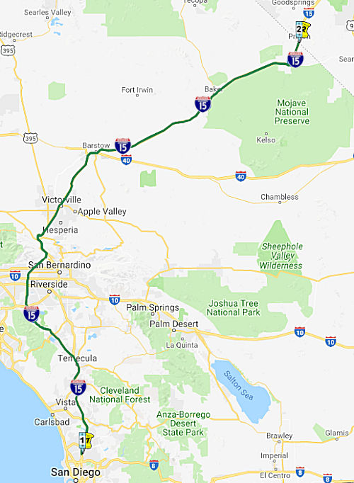 From Route 8 to the Nevada state line near Primm (formerly Stateline), Nevada
via the vicinity of Temecula, Corona, Ontario, Victorville, and Barstow.
From Route 8 to the Nevada state line near Primm (formerly Stateline), Nevada
via the vicinity of Temecula, Corona, Ontario, Victorville, and Barstow.
[Note: See also the more detailed maps on I-215, US 395, Route 31, and Route 194]
 Suffixed Routings
This route has a complicated numbering history, described below. The original (1947) plan was to have I-15 terminate at I-10, using the present-day I-215 alignment. US 395 would then continue to San Diego. In 1965, the US 395 segment was renumbered as TEMP I-15/US 395. In 1969, that corridor became I-215, and a new western alignment was created for I-15 that used existing Route 71 between US 395 and Route 91, and a new alignment (approximating former Route 31 in portions) between Route 91 and Devore. "I-215" and I-15 rejoined near Temecula. In 1974, I-215 was resigned as I-15E (with a real route number of Route 194), with the expressway portion signed as TEMP I-15E. In 1983, the I-15E signage was changed back to I-215; Route 194 was deleted, and Route 215 was created as non-chargable interstate.
Scott Parker on AAroads provided an even more detailed history:
(Source: Scott Parker on AARoads, “Re: Interstate 15E signage in San Bernardino and Riverside Counties?”, 7/12/2016)
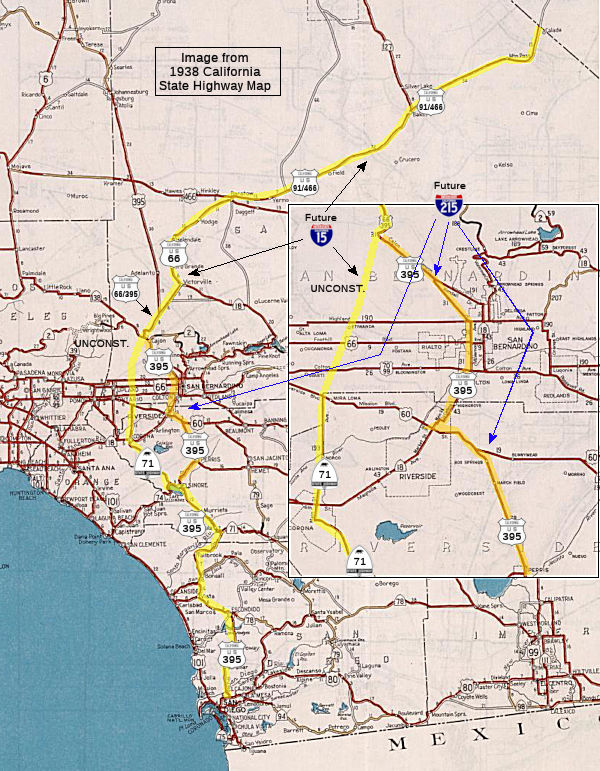
It all started with the I-15 extension south to San Diego, part of the 1968 1500-mile Interstate expansion legislation. Originally, the concept was to take I-15 directly south from the original I-10 junction at Colton, continue south on the ridge betwen Reche Canyon and Pigeon Pass, and then descend the mountain near the present east junction of Route 60 and I-215, and then segue onto what was then US 395 south past March AFB and on to San Diego. That concept didn't last long -- just as long as it took to do a detailed survey of the proposed route -- the mountains in that area are basically a pile of unstable compressed sandstone "rocks"; a construction nightmare. A more "flatland" approach was explored to the west, diverging from US 395 between Grand Terrace and Highgrove (both between Colton and Riverside), heading south east of Iowa Avenue, then following the Santa Fe rail line along the base of the mountains -- directly behind UC Riverside -- and merging with Route 60/US 395 (now Route 60/I-215) just north of the present route split in Moreno Valley. You can guess how that went over with the UC Riverside community -- it would have wiped out a whole nest of apartments serving as student housing -- not to mention being across the street from the Chancellor's official residence! By the end of 1969, that option was also kaput.
Early in 1970 District 8 planners came up with an alternate that solved more than a few issues -- the proposed Route 31 freeway, extending north from Corona through eastern Ontario before turning northeast along the base of the San Gabriel mountains to intersect I-15 at Devore, the point where the route started climbing Cajon Pass. Realigning I-15 over this route would cut about 23 miles off the Los Angeles-Las Vegas I-10/I-15 routing by eliminating the "backtracking" route via San Bernardino. And, lo and behold, the south end of the Route 31 freeway continued south of Corona as the Route 71 proposed freeway (actually, about 10 miles of it had been constructed circa 1967 between Corona and Lake Elsinore), which itself merged with US 395 at Murietta, just north of Temecula. While about ten miles longer than the existing I-15/US 395 route through Riverside and Perris, this reroute concept drew not only attention from the local press but also that in L.A.—virtually all favorable to the idea. By mid-1970 the Division of Highways had decided to strongly pursue the Route 31 option. AASHTO (at that time, without the first "A") concurred, and the matter reached FHWA by the beginning of fall.
At first, FHWA raised an objection to the funding of the former Route 31 section from I-10 north to the existing I-15 at Devore because of the existence of the in-place I-15 through San Bernardino, which had been previously the recipient of chargeable Interstate funds. But a perusal of the records showed that the segment between I-10 and 5th Street in San Bernardino had commenced construction in early 1956 -- almost a year before Interstate funds were first disbursed; only the segment north of there was actually part of chargeable construction. Negotiations commenced, and an agreement was finally made near the end of 1970 whereby California would waive any rights to Interstate maintenance or reconstruction funds for the original I-15 segment between I-10 and Devore in exchange for full funding of the entire Route 31/Route 71 corridor as the realigned I-15. Once that agreement was finalized, the Division accelerated construction of the Devore freeway-to-freeway interchange, already in progress as part of the I-15 Cajon realignment, along with the first couple of miles of the new (then) Route 31 alignment, which opened by the spring of 1971 (this was pre-STIP days, when the Division could do such things without much in the way of outside interference).
Around this time (1970-71), US 395 from Moreno Valley to Perris saw some "Temporary I-15" signage -- prior to the 1971 decision to route the mainline I-15 south along the Route 31 freeway alignment through Ontario (and along Route 71 south of Corona)
However, as soon as the dust had settled on the reroute, the cities of San Bernardino and Riverside voiced concerns that this new routing, which completely bypassed their city centers, would have a negative effect on their development plans. Together, these cities had devised a plan whereby the new western route via Corona and Ontario would become I-15W, while US 395 would be renumbered I-15E, regardless of the actual non-Interstate status of the latter route -- but keeping an Interstate route through their midst. AASHTO quickly shot down the full E/W split, but reserved the notion of at least keeping US 395 through San Bernardino signed as an Interstate until the Ontario-Devore segment of the new alignment could be completed. And as this was several years prior to the decision to eliminate suffixed Interstate numbers, they approved the signage of the I-10 to Devore segment as I-15E (the Division had the entirety of US 395 from Murietta to Devore redesignated as an unsigned Route 194, a number previously decommissioned elsewhere). Initially, I-15E was intended to be a purely temporary designation -- but that it existed at all (signed as such in late 1972) placated the city of San Bernardino for the time being. As a result, the "Temporary I-15" signage was replaced by the beginning of 1973 with "Temporary I-15E" signage after the portion of I-15 from Devore south to I-10 was re-designated (and signed) as I-15E as a result of the prior I-15 rerouting decision. That signage was extended south along US 395 -- through the notorious Riverside cloverleaf interchange -- all the way to the south/east US 395/US 60 split near Moreno Valley. South from there the "temporary" signage prevailed.
However, the city of Riverside did not hesitate to voice their objections to being left out of the Interstate network. They "lucked out", however due to inadvertently good timing: the Nixonian "block grant" legislation, passed in early 1973 prior to that administration's functional crippling in the wake of the Watergate scandal, introduced the concept of "chargeable/nonchargeable" Interstate delineation. Now the 15E concept could, with AASHTO/FHWA consent, be extended south along US 395, rejoining the new I-15 at Murietta, as a nonchargeable route. With a major push from the local Congressional delegation, this was done by the spring of 1974. I-15E was signed in place of US 395 as far south as the Route 60 split at Moreno Valley; the remainder of the route south to Murietta was signed, by mid-1975, as "Temporary I-15E" and south of the Route 71 merge at Murietta as "Temporary I-15". This configuration lasted for a few years until the decision to eliminate suffixes was made.
On the I-15 side of the equation: Hamner Avenue was signed as "Temporary I-15" once I-15 was constructed south to Route 60 in 1980 (it had reached I-10 a year earlier). Prior to that Route 31 signage existed along Hamner as well as its Milliken Ave. extension in eastern Ontario north of there. Route 31 signage was largely removed (except for a few "straggler" signs in Corona and Norco) when the temporary I-15 signage was erected. That temporary signage extended south of Route 91 as well along then-Route 71 to the original 4-lane freeway section from south Corona to north of Lake Elsinore. That segment got actual I-15 signage circa 1979-80.
Renumbering of the completed and uncompleted portions of I-15E was proposed circa 1979; Caltrans made one of their rare appropriate renumbering decisions: to reinstate the number 215, which was an urban surface-street connector in Pomona before it was deleted from the state highway system in 1965. AASHTO and FHWA vetted the 15E to 215 change by 1981; the renumbering in the field took place in 1982. Although some sections were technically substandard, the route was by that time mostly full freeway; a short segment between Sun City and Perris still featured a couple of at-grade crossing roads, while the segment from Perris to Route 60 was still a divided facility with numerous at-grade and/or signalized intersections [Ed: I remember this segment from numerous trips to OERM in Perris]. The "temporary" designation concept had been dropped by Caltrans at that point; the section between the Murietta I-15 divergence and Route 60 was (IMO somewhat absurdly) signed as "TO I-215" northbound, and as Route 215, complete with green shields, southbound. This unwieldly situation persisted until the two sections featuring cross traffic were upgraded to full freeway in 1995. The in-city Riverside segment of I-215 featured one of the most underpowered Interstate "Turn Off To Stay On" (TOTSO) interchanges (in both directions, including a 25mph loop southbound) until 2004, when the southbound I-215 2-lane flyover was completed; the northbound outside ramp still shrinks to a single lane before merging with lanes continuing from the terminating Route 91. It's still a TOTSO—but not quite as obnoxious as before!
(Source: Sparker @ AAroads, "Re: Interstate 15E signage in San Bernardino and Riverside Counties?", 7/12/2016; WasI-15 signed along Hamner Avenue in Norco and Corona, California?, July 2018)
There were also Temporary I-15 signs from the San Diego County line south through Escondido on two-lane old US 395, until it was replaced by four-lane (then quickly expanded to eight-lane) I-15. Note that, for a time, "Temporary I-15" was the only route signage on that road. I-15 was completed through northern San Diego County around 1986.
There may have been Temporary I-15 shields in San Diego, on Murphy Canyon Road between I-8 and Route 163 (former US 395), before it was upgraded to a substandard freeway around 1985, and possibly thereafter until it was completely rebuilt.
Post 1964 Signage History▸ In 1963, Route 15 was defined as "Route 15 is from Route 10 in San Bernardino to the Nevada state line near Calada via Barstow.".
As part of the renumbering in 1964, signage for US 91 was truncated to
end in Barstow instead of Long Beach (but this did not correspond to
California Route 91, which ended at US 395 near Riverside as of 1964). At
the same time, signage of US 466 was truncated to end in Baker (California
Route 58, former US 466, ended in Barstow). See the linked
Gribblenation blog for more details, including links to maps and
pictures.
(Source: Gribblenation Blog (Tom Fearer), “Interstate 15; the Mojave Freeway from Barstow to the Nevada State Line”, April 2021)
By 1965, I-15 was announced as being completed to freeway standards north
of Barstow, including a bypass of Yermo. 1965 also saw a 18 mile segment
of recently opened freeway through Baker, relocating US 91/I-15 to a
bypass of the community (and the original surface routing became a
business route). In 1966, the AASHO Executive Committee approved a
Division of Highways request to truncate signage of US 91 to Route 127 in
Baker. With the opening of this bypass, US 466 terminated at the Route 127
exit from I-15.
(Source: Gribblenation Blog (Tom Fearer), “Interstate 15; the Mojave Freeway from Barstow to the Nevada State Line”, April 2021)
▸ In 1968, Chapter 282 relaxed the definition to be "Route 15 is from Route 10 near San Bernardino to the Nevada state line near Calada via Barstow."
In December 1968, the 1968 Federal Aid Highway act provided $201.2 million for construction of a new routing for I-15 from San Diego to Colton, a distance of 102.5 miles. As a result of this, in 1969, Chapter 294 transferred the portion of former US 395 from the I-5/US 395 (present-day I-5/Route 163) junction to I-10 in San Bernardino to Route 15 as an initial routing. Section (a) of the routing was added by transfer from Route 103, and this segment was redefined to be "Route 8 to the Nevada state line near Calada via Temecula, San Bernardino, and Barstow and passing near Riverside."
 In September 1969, a route location for the portion of I-15 between 1.6 mi S of Lilac
Road and 1.9 mi N of Route 76 was adopted. Design hearings for this route
were held in 1970. Note that this explains where there are still a few
Route 15 postmiles on the segment of Old 395 bypassed by this routing.
In September 1969, a route location for the portion of I-15 between 1.6 mi S of Lilac
Road and 1.9 mi N of Route 76 was adopted. Design hearings for this route
were held in 1970. Note that this explains where there are still a few
Route 15 postmiles on the segment of Old 395 bypassed by this routing.
(Source: Times-Advocate, 7/9/1970 via Joel Windmiller, 2/19/2023)
With respect to the Devore interchange, Scott Parker on AAroads provided the following history:
Grading for the Devore interchange began in early 1969 as the final part of the project that rerouted I-15 up the hillside north of there away from the original US 66/US 395 route alongside the RR tracks in the Cajon canyon; bridge construction was begun later that year, just prior to the commencement of negotiations about rerouting I-15 onto Route 31. The initial segment of the Route 31 freeway was an extended "stub-end", depositing local traffic on Lytle Creek Road; that opened to traffic in late 1970. At that time, there were Route 31 white post-miles, and the nascent freeway was signed "To Lytle Creek Road/Local Traffic Only" from I-15. Route 31 reassurance signs may not have been posted. The portion of the original I-15 southeast of the Devore interchange was re-signed as I-15E at the end of 1972, along with white mileage paddles indicating the legal definition of that route as Route 194. The transition ramp from the Route 31 stub to north I-15 was originally only 2 lanes over the separation bridge, but dropping to a single lane before merging with the existing I-15; this had been corrected by the time the entire facility to Ontario (and beyond) was opened to traffic.
The "Cajon Connection" was an existing 2-lane county road parallel and just to the south of the new freeway; it is still there, serving as an accessway to the Glen Helen amphitheater and recreation area. Later, well after I-15 was completed through the area, this connection was realigned across the new freeway and an interchange serving Glen Helen was built about halfway between Lytle Creek and I-215. Because of the events held at Glen Helen (concerts, conventions, etc.) the Connection has gradually been upgraded over the years; the eastern portion connecting Glen Helen to I-215 just south of the I-15 interchange was always hampered by twin grade crossings of the UP and BNSF parallel tracks (BNSF would run over 100 trains, mostly containerized cargo, per day over Cajon Pass); just recently an overpass was built to separate the grade there.
(Source: Scott Parker at AAroads, "Re: Why is the Interstate 15 route looks like a bypass of San Bernardino & Riverside", 7/18/2016)
(Source: Scott Parker at AAroads, "Re: Why is the Interstate 15 route looks like a bypass of San Bernardino & Riverside", 7/18/2016)
In 1971, US 466 was eliminated as a US Route by the AASHO Executive
Committee. This request was made by the Division of Highways in
reference to the remaining segment of US 466 multiplexed with I-15 to
Route 127 in Baker. In 1974, Caltrans petitioned AASHO to truncate US 91
from California. This request by Caltrans was made alongside
additional requests to truncate US 91 from Nevada and Arizona. In 1974, US 91 was truncated to terminate in Brigham City, Utah.
(Source: Gribblenation Blog (Tom Fearer), “Interstate 15; the Mojave Freeway from Barstow to the Nevada State Line”, April 2021)
▸ In 1974, Chapter 537 redefined the route to the west as "Route 8 to the Nevada state line near Calada via the vicinity of Temecula, Corona, and Barstow." The portion of previous Route 15 from Route 71 (present-day I-15) near Temecula to Route 31 (present-day I-15) near Devore was transferred to Route 194, which was renumbered as Route 215. The portion of Route 71 from Route 15 (the present-day southern end of I-215) to Route 91, and former Route 31 from Route 91 to I-15 (the present-day northern terminus of I-215). were transferred to I-15.
▸ In 1994, Chapter 1220 further tightened the definition to be "Route 8 to the Nevada state line near Stateline, Nevada via the vicinity of Temecula, Corona, Ontario, Victorville, and Barstow."
Pre 1964 Signage HistorySee below for the pre-1964 routing of Route 15.
Pre-1964 Routing of Present-Day Route 15
 Before the 1974 renumbering (yes, 1974!), everything is all confused. The routing can be broken up into the
following segments:
Before the 1974 renumbering (yes, 1974!), everything is all confused. The routing can be broken up into the
following segments:
Discussion of the routing pre-1964 will generally be found on the pages for the pre-1964 route components—that is, US 395, Route 71, Route 74.
 In 1951, the CHC proposed relocation of a 20 mi segment
of Route 71 between Murietta and Alberhill (about a mi N of Lake
Elsinore), and started the hearing process on the proposal. The new
location was E of the present road, and started E of Murietta at the
junction of the future direct route for US 395 from Temecula to Perris
(now I-215), passing through Elsinore, and rejoining the existing Route 71
near Alberhill. The road was to be an improved and widened two-lane
highway, half of a planned future four-lane divided expressway (which,
post-1964, became I-15). The plan was for the new road to eliminate sharp
curves and excessive grades, cutting two miles from the earlier route. The
route was moved E of the existing highway to avoid disturbing existing
homes in Sedco, a community S of Elsinore.
In 1951, the CHC proposed relocation of a 20 mi segment
of Route 71 between Murietta and Alberhill (about a mi N of Lake
Elsinore), and started the hearing process on the proposal. The new
location was E of the present road, and started E of Murietta at the
junction of the future direct route for US 395 from Temecula to Perris
(now I-215), passing through Elsinore, and rejoining the existing Route 71
near Alberhill. The road was to be an improved and widened two-lane
highway, half of a planned future four-lane divided expressway (which,
post-1964, became I-15). The plan was for the new road to eliminate sharp
curves and excessive grades, cutting two miles from the earlier route. The
route was moved E of the existing highway to avoid disturbing existing
homes in Sedco, a community S of Elsinore.
(Source: Lake Elsinore Valley Sun-Tribune, 10/25/1951, via Joel
Windmiller1/29/2023)
A good article on the history of the Cajon Pass may be found here, as well as at MojaveDesert.net and Tom Fearer's Gribblenation post. The old Indian trail followed by later Spanish explorers crossed the San Bernardino Mountains east of the Cajon Pass on the ridge between Devil and Cable Canyon through present day Cedar Springs, and followed the Mojave River into the desert. This was the route taken by the first American to push into San Bernardino from the east. In 1861, John Brown Sr., built a toll road from Devore to the Cajon Pass Summit under a state franchise good for 20 years. Tolls ranged from 3 cents per head of sheep to $1 for a wagon and pair of animals.
Tom Fearer provides more information on this: The discovery of gold
brought a significant influx of travelers to Cajon Pass which required
road improvements to handle the increased traffic. In April of 1861 the
State of California authorized legislation to construct a wagon road
through Cajon Pass. A toll franchise was granted by the State to John
Brown, Henry Willis and George Tucker to improve the road through Cajon
Pass, this was the genesis of the Cajon Pass Toll Road. In the mid-19th
Century the State of California typically granted twenty year franchise
rights to organizers who would fund and construct wagon routes. The Cajon
Pass Toll Road did not utilize Sanford's Cutoff but instead utilized an
improved route through Crowder Canyon. By 1863 John Brown had bought out
the shares of his co-stake holders in the Cajon Pass Wagon Road. The Cajon
Pass Wagon Road in the early years was subject to heavy flood damages and
toll house attacks by local tribes. In 1874 the Cajon Pass Wagon Road
became stable enough for John Brown to plan improvements in the upper
parts of the road which were more direct and less steep. Part of the
improvements included a 185 foot cut which is now part of Forest Route 3N45, this cut would be utilized into early US Route era. In 1878 John
Brown sold his rights to the Cajon Pass Toll Road to Jesse Tay and Charles
Lawrence. The franchise toll rights to the Cajon Pass Toll Road expired in
October of 1882 and the it became a public facility once again.
(Source: Gribblenation Blog: Cajon Pass; Cajon Pass Toll Road, National Old Trails Road, US Route 66/91/395 and Interstate 15)
At about the time that the franchise on Brown's Turnpike expired and it became a county road, the railroads were engaged in a struggle to put tracks through the pass. The Southern Pacific ended up purchasing the right to build through the Cajon when it took over the bankrupt Los Angeles and Independence Railroad. Meanwhile, Santa Fe officials were informed of the lower pass through the East Cajon and under the name "California Southern Extension Railway," tracks were laid from San Bernardino to Barstow, causing the Southern Pacific to run its line to Los Angeles.
In Mid-December 1915, California formally took over the maintenance of
the Cajon Pass Boulevard, from San Bernardino city limits to Summit,
relieving the county from the expense of the upkeep of the concrete and
macadam highway. This move marked the first big step by the state in
extending its operations to the Old Trails highway. The announcement noted
that the surveys have been run from Summit to Barstow for the new portion
of the road, but the definite route has not been selected. The state and
the county are to build the Summit to Barstow section within a period of
not to exceed five years. The state will first build from the vicinity of
Victorville. As of 1915, the state was now operating 130 miles of highway
in this county, including the newly-aquired Cajon road. This includes
about 60 miles of the Rim of the World highway, 30 miles on the Foothill
boulevard, 15 miles on the Valley boulevard, and 25 miles on the Cajon
road. Later the state will take over a route from San Bernardino to the
Riverside county line on the Imperial valley highway. The Cajon road will
henceforth be known as a state highway.
(Source: Jim Umbach, on California Historical Highways on FB, 11/10/2018)
The 1918 State Highway Map is first California Road map to clearly show
state maintenance over Cajon Pass. Although this map below shows the
National Old Trails Road (forerunner to US 66) on the 1914 alignment it
was quickly realigned to the west over the gentler grades of Cajon Summit.
Some reports state that the NOTR/LRN 31 was realigned over Cajon Summit by
late 1916 (specifically Mike Boultinghouse who is a well renown source on
The National Old Trails Road Page on Facebook) whereas others state it was
complete by 1918. For reference the California State Automobile
Association shows the NOTR/LRN 31 routed through Crowder Canyon and
through Cajon Pass in on their 1917 State Highway Map.
(Source: Gribblenation Blog: Cajon Pass; Cajon Pass Toll Road, National Old Trails Road, US Route 66/91/395 and Interstate 15)
In November of 1926 the US Route System was approved and US Route 66 was
plotted to cross over Cajon Summit. The earliest route of US 66 utilized
the improved route of the NOTR built as part of LRN 31 in 1918. Most
reports cite that US 66 (along with the other US Routes) was first signed
in California by 1928 replacing the NOTR. The 1918 alignment of the
NOTR/LRN 31 would later be straightened by 1930 with final bridge work
coming in 1931. It appears the path of the NOTR and Cajon Pass Toll Road
was largely abandoned after the 1918 realignment. Part of the NOTR/Cajon
Pass Toll Road became part of an extension of LRN 59 in 1933 which was
numbered as California State Route 2 by 1934. State Maintenance of LRN 59
can clearly be seen east of LRN 31 in Cajon by 1935. At some point in late
1934 or early 1935 US Route 395 was extended into Southern California and
joined US 66 in Cajon Pass. In 1947 US 91 was extended south from Barstow
via Cajon Pass into Long Beach.
(Source: Gribblenation Blog: Cajon Pass; Cajon Pass Toll Road, National Old Trails Road, US Route 66/91/395 and Interstate 15)
See the Gribblenation Blog (excerpted here) at Cajon Pass; Cajon Pass Toll Road, National Old Trails Road, US Route 66/91/395 and Interstate 15 for detailed maps of the various routings of the highways that would become both I-15 and Route 138 in the Cajon Pass.
In 1953, construction of a freeway through the pass was completed, at a cost in excess of $2,100,000 for the southerly 9.3 miles of the pass between Devore and Gish Underpass about four miles south of the summit. About half of the old two lanes built in 1932 were converted to use for one-way traffic, with two additional lanes constructed for traffic in the opposite direction. Four new lanes of pavement have been constructed for about five miles.
 Realignment Victorville to Barstow") In 1954, the CHC considered adoption of a freeway
relocation of (then) US 91 and US 66 between Victorville and Barstow. The
new routing would cut 4.7 mi from the distance. The route would start N of
Victorville, swing E and traverse scenic desert areas that were not open
to auto travel. It would connect to the pre-1954 highway N of Barstow.
Bypassed would be the desert communities of Oro Grande, Helendale, and
Lenwood. The article noted that extensive work had just been done from
Devore to S of Cajon Summit in June 1953, and a contract had just been let
for a four lane road from Cajon Summit to Palmdale Road, S of Victorville.
For the new routing, plans call its eventual expansion to a multi-lane
highway.
In 1954, the CHC considered adoption of a freeway
relocation of (then) US 91 and US 66 between Victorville and Barstow. The
new routing would cut 4.7 mi from the distance. The route would start N of
Victorville, swing E and traverse scenic desert areas that were not open
to auto travel. It would connect to the pre-1954 highway N of Barstow.
Bypassed would be the desert communities of Oro Grande, Helendale, and
Lenwood. The article noted that extensive work had just been done from
Devore to S of Cajon Summit in June 1953, and a contract had just been let
for a four lane road from Cajon Summit to Palmdale Road, S of Victorville.
For the new routing, plans call its eventual expansion to a multi-lane
highway.
(Source: San Bernardino County Sun 5/1/1954, via Joel Windmiller,
2/25/2023)
Barstow to the Nevada State Line
North of Barstow, the plan was for US 91 to eventually become interstate.
A 1955 planning map shows the potential Interstate north of Barstow to the
Nevada State Line as a being planned as a four-lane limited access road
slated to be complete by 1965. As part of the conversion to interstate
highway, in 1961 the Barstow Bypass opened. The Barstow Bypass included
the exit ramp to I-40 and the first stub of the future I-15 freeway
eastward towards Needles. The Barstow Bypass included a ramp north
of the Mojave River from which US 466 (Route 58) eastbound joined US 91/I-15 northbound at what is now Exit 186/Old Highway 58. The
Barstow Bypass was an extension of a 24 mile segment of US 91/US 66/I-15
that had opened to traffic north of Victorville during January of
1959. Also opening in 1961 was a full freeway alignment of US 91/US 466/I-15 across the Baker Grade. This 25 mile segment originated
from the eastern outskirts of Baker towards Halloran Summit at Cima Road.
The original surface routing in Barstow became a business routing. US 91
Business in Barstow followed much of it's original surface alignment on
what was US 466 (now Old Highway 58), 1st Avenue and Main
Street. The US 91 Business route looped back to US 91/US 66/I-15 via
ramps from Main Street that have been since replaced with the I-15 L
Street Exit. Lastly, in 1963, a 45 mile segment of US 91/US 466/I-15 was
being constructed from Yermo to Cronese Valley, and the freeway segment
from Cima Road northeast to the Nevada State Line opened during October
1963. See the linked Gribblenation blog for more details, including
links to maps and pictures.
(Source: Gribblenation Blog (Tom Fearer), “Interstate 15; the Mojave Freeway from Barstow to the Nevada State Line”, April 2021)
Scott Parker on AARoads provided more information on the planning for the
Barstow Bypass: When the original I-15 Barstow Bypass was built, one of
the design features—the wye interchange for the business loop,
featuring left-exits and entrances from and to NB I-15—was to be the
original junction of westward US 466, which was, like its relocated Route 58 successor, planned to be a freeway for at least the portion crossing
the Santa Fe yards and the adjacent Mojave River. But that
configuration never came to fruition, partially because Santa Fe expanded
their yards westward, relocating the junction between the L.A. and Bay
Area lines to right where the US 466 freeway was intended to go. Not
wanting to deploy a continuous line of longer bridges—and rethinking
the left-exit/entrance concept—Caltrans D8 negotiated an alternate
parallel path a little less than a mile west—and coordinated with
Santa Fe for a mutual easement for both (by then) the Route 58 freeway
stub and the relocated line to Mojave, Bakersfield, and beyond. The
rail line and the 1997-opened Route 58 freeway shadow each other into
Hinkley before diverging. But from 1961 to the 1964 statewide
renumbering, the plans were for both US 91 and US 466 to follow I-15 to
the original west Barstow interchange, where US 466 would
diverge—but for about two miles US 466 and "parent" US 66 would have
a shared alignment once the original freeway plans were realized.
(Source: Scott Parker on AARoads, “Re: Former US Route 91/466 in Baker”, 4/9/2021)
 In 1934, Route 15 was signed along the route
from Long Beach to Jct. US 99 near Monterey Park via Atlantic Blvd. This was
renumbered as Route 7 in 1964, and was later renumbered again as I-710. It
was LRN 167 (defined in 1933 and extended in 1947). Until the construction
of the freeway, Route 15 ran between Pacific Coast Highway and US 99 along
Atlantic Blvd. By 1957, Route 15 ("Long Beach Freeway") had been constructed
between Anaheim Ave and Atlantic Ave. In 1964, the freeway routing was
renumbered as Route 7, and was later renumbered as I-710. See the pages on
Route 710 and Route 7 for additional details. Note that the portion N of
I-10 was not part of 1934 Route 15.
Status
In 1934, Route 15 was signed along the route
from Long Beach to Jct. US 99 near Monterey Park via Atlantic Blvd. This was
renumbered as Route 7 in 1964, and was later renumbered again as I-710. It
was LRN 167 (defined in 1933 and extended in 1947). Until the construction
of the freeway, Route 15 ran between Pacific Coast Highway and US 99 along
Atlantic Blvd. By 1957, Route 15 ("Long Beach Freeway") had been constructed
between Anaheim Ave and Atlantic Ave. In 1964, the freeway routing was
renumbered as Route 7, and was later renumbered as I-710. See the pages on
Route 710 and Route 7 for additional details. Note that the portion N of
I-10 was not part of 1934 Route 15.
StatusIn his 2006 Strategic Growth Plan, Governor Schwartzenegger proposed widening this route for HOV lanes, and the addition of Managed Lanes in San Bernardino.
Route 8 in San Diego to Temecula (I-15/I-215 split)
Integrated Corridor Management (~ SD R10.67 to ~ SD R31.392)
In April 2016, it was reported that Caltrans has
switched on electronic freeway signs intended to make the North County
Inland commute a bit easier. The signs are posted along a 20-mile stretch
of I-15 between just north of Route 52 in San Diego and Route 78 in
Escondido. If there's an incident on the I-15 that will cause a
significant backup, the signs will direct drivers to alternate routes on
surface streets. The system will also control traffic signals on those
surface streets to keep them from getting too congested. Caltrans and the
San Diego Association of Governments built the system with $10.8 million
in state and federal grants.
(Source: KPBS, 4/21/2016)
The "signs" referred to above are part of an Integrated
Corridor Management program from SANDAG. These signs define a series of 40
alternate routes for use when the freeway becomes congested. The
electronic freeway signs work in conjuction with the local 511 system to
direct drivers to the particular alternative route to take. For example,
if a driver on the I-15 encounters a traffic jam, the 511 app will suggest
alternative routes to try and get around the traffic. It will speak to the
driver that there's an incident ahead and tell you which exit to exit and
then to follow the signs for a particular lettered alternative route, with
the goal of preserving a consistent drive time. In 2010, the I-15 corridor
in the San Diego region was selected as one of two pilot sites in the
nation to develop, implement, and operate an Integrated Corridor
Management (ICM) system. The ICM system allows individual transportation
systems to be operated and managed as a unified corridor network. The ICM
system went live in early 2013. ICM uses cutting-edge technology to
operate and manage individual transportation systems as a unified network.
It allows freeway, surface street, and transit networks to be managed
together to improve mobility and maximize system efficiency. The project
covers a 20-mile section of I-15 from just north of Route 52 in the City
of San Diego to Route 78 in the City of Escondido, including the
state-of-the-art I-15 Express Lanes and major arterial routes on either
side of I-15 within several miles of the freeway. The project applies
predictive algorithms and real-time modeling tools to forecast traffic
across multiple networks and recommend response plans to manage
anticipated congestion. For example, the ICM system coordinates the use of
freeway ramp meters and arterial traffic signals to improve day-to-day
conditions or to route traffic around major incidents. ICM reduces delays
and improves travel reliability. The system is designed to efficiently
guide drivers around incidents with the least amount of impact to local
streets. As part of the project, a coordinated detour messaging system was
activated in April, 2016 with 40 alternate route signs installed on surface streets along the I-15
corridor in the cities of Escondido, Poway, and San Diego. Should a major
freeway incident occur, Caltrans overhead changeable message signs on I-15
will direct motorists off the freeway to avoid delays, and alternate route
signs will guide motorists through surface streets and back onto the
freeway as soon as possible.
(Source: SANDAG ICM Page)
In August 2016, it was reported that the CTC earmarked
just over $22 million for the installation of 128 transportation
management system monitors to track traffic conditions on I-15, from a
quarter-mile north of the San Diego County line to Route 91 in Riverside.
(Source: Banning Patch, 8/23/2016)
Miramar Bicycle Path
In October 2016, it was reported that there were once
plans for a bicycle path along I-15 in the Miramar area. In 1979, a
bicycle path was constructed along what is now Kearny Villa Road from
Harris Plant Road to Carroll Canyon Road (~ SD M11.787 to SD M14.946) .
Starting at Harris Plant Road, bicyclists were directed from Kearny Villa
Road, across the freeway, to Altair Road. About 1/4 mile north on Altair
Road, the Class I bicycle path began. It followed Altair Road for a short
distance, crossed under the freeway at San Clemente Canyon, and then
followed the east side of the freeway. Once it joined with Ammo Road, it
was basically a Class II bike lane. The lane followed the shoulder of I-15
from near Miramar Way all the way to Carroll Canyon Road, where it exited
the freeway and terminated. Much of the Class I sections of the path
remain today, albeit closed off. Maps and photos are available off the
source link.
(Source: Michael Ballard at So Cal Regional Rocks and Roads, October 2016)
In the December 2017 Caltrans Mile Marker, it was noted: In August 2017, a ribbon cutting was held for the opening of the Route 15 Commuter Bikeway, a one-mile, two-way bikeway facility adjacent to Route 15 in San Diego. The bikeway is separated from the freeway using a concrete barrier, and the path will provide a direct route between two neighborhoods in San Diego. The bikeway will be lit to allow riding during evening hours.
I-15 Managed Lane Project (~ SD M11.795 to SD R31.287)
The SAFETEA-LU act, enacted in August 2005 as the reauthorization of TEA-21, provided the following expenditures on or near this route:
In his 2006 Strategic Growth Plan, Governor Schwartzenegger proposed construction of Managed Lanes - North/South Segments.
![[TCRP Project 83]](maps/015-tcrp-83.jpg) There are plans to add a high-tech managed lane on I-15 N of San Diego from
Route 163 to Route 78 (~ SD M11.795 to SD R31.287) (see map to the right).
This is TCRP Project #83. There are two subprojects: Project #83.1 —
adds the transit elements to support the high-tech managed lane (i.e.,
acquisition of buses and construction of bus rapid transit centers along
the I-15 freeway to implement a bus rapid transit system, with
preferential access provided to buses and carpools via direct access
ramps). This phase is scheduled to be completed in July 2008. Project
#83.2 add the freeway elements for the high-tech managed lane. In April
2006, the CTC considered a proposal to amend the project application to
TCRP Project application amendment to: (1) transfer $23,100,000 in TCRP
funding from #83.1 to #83.2; (2) update project schedule and funding plan
for both projects; (3) redistribute $3,663,000 from Right of Way on #83.2
to Construction. Project #83.1 has the following completion dates as of
April 2006: Phase 1: FY 2003/2004; Phase 2: FY 2005/2006; Phase 3: FY
2005/2006; Phase 4: FY 2008/2009. Project #83.2 has the following
completion dates as of April 2006: Phase 1: FY 2003/2004; Phase 2: FY
2005/2006; Phase 3: FY 2005/2006; Phase 4: FY 2008/2009.
There are plans to add a high-tech managed lane on I-15 N of San Diego from
Route 163 to Route 78 (~ SD M11.795 to SD R31.287) (see map to the right).
This is TCRP Project #83. There are two subprojects: Project #83.1 —
adds the transit elements to support the high-tech managed lane (i.e.,
acquisition of buses and construction of bus rapid transit centers along
the I-15 freeway to implement a bus rapid transit system, with
preferential access provided to buses and carpools via direct access
ramps). This phase is scheduled to be completed in July 2008. Project
#83.2 add the freeway elements for the high-tech managed lane. In April
2006, the CTC considered a proposal to amend the project application to
TCRP Project application amendment to: (1) transfer $23,100,000 in TCRP
funding from #83.1 to #83.2; (2) update project schedule and funding plan
for both projects; (3) redistribute $3,663,000 from Right of Way on #83.2
to Construction. Project #83.1 has the following completion dates as of
April 2006: Phase 1: FY 2003/2004; Phase 2: FY 2005/2006; Phase 3: FY
2005/2006; Phase 4: FY 2008/2009. Project #83.2 has the following
completion dates as of April 2006: Phase 1: FY 2003/2004; Phase 2: FY
2005/2006; Phase 3: FY 2005/2006; Phase 4: FY 2008/2009.
Related to this project is the widening of I-15. As of January 2006, the middle portion of the estimated $1 billion widening of I-15 between Escondido and Route 163 in San Diego is about half done. Motorists who drive the route now see a long ribbon of concrete separating the freeway's north- and southbound lanes, concrete that will eventually be part of the "managed lanes" portion of the project. "We should have the middle segment ... lanes opened around late 2007 or early 2008," said Gustavo Dallarda, the California Department of Transportation's manager for the I-15 project. "When we finish the middle segment, we'll start on the north and south segments simultaneously." Ever since late 2003, I-15 commuters have seen constant work along the freeway between Lake Hodges and the Miramar area as workers construct what eventually will be a 14-lane freeway. The managed lanes are essentially reversible lanes that will allow the four lanes separating today's north and south lanes to absorb peak commute traffic. Monitors will use a movable concrete barrier to decide how many lanes are needed in the southbound direction in the morning and how many during the late-afternoon drive home. The extra lanes will help alleviate and possibly end the backups motorists now experience. About 300,000 vehicles use that stretch of I-15 each day with peak commute times between San Diego and Escondido taking 30 to 45 minutes, according to the latest data from the San Diego Association of Governments, the region's primary transportation planning and funding agency. The initial work involved construction of one additional lane in each direction. Much of the work now is centered at interchanges, overpasses and bridges that span the 21-mile project. [Information from the North County Times]
The 2007 Corridor Mobility Improvement Account also received a request regarding this segment. Approved for funding was $350 million for managed lanes from Route 163 to Route 56. Also submitted were managed lanes on the Mira Mesa access ramp ($50 million), but this wasn't approved for funding.
In late 2007, a request for construction bid was advertised for managed lanes SB on I-15 from Mira Mesa Boulevard (~ SD M15.94) to 0.3 Kilometers South of the Route 56/I-15 (~ SD M19.192) Separation Overcrossing.
In 2008, Chapter 421 (AB 1954, 9/27/2008) authorized a value pricing and transit program involving HOT lanes to be developed and operated on Route 15 in Riverside County by the Riverside County Transportation Commission. The bill required the Riverside County Transportation Commission and the Department of Transportation to implement the program pursuant to a cooperative agreement that addresses specified matters in connection with the program and to establish appropriate traffic flow guidelines, as specified. The bill authorized the Riverside County Transportation Commission to impose tolls and issue revenue bonds for the HOT lane project. The bill also authorized toll revenues to be used for specified purposes related to the project and to Route 15. The bill noted that the commission is not entitled to compensation for the adverse effects on toll revenues due to construction of competing facilities by the department or local agencies.
In August 2008, Caltrans released for bid the project to construct the north segment of the managed lanes in San Diego County in and near Escondido at various locations from 0.1 KM south of the Highland Road overcrossing (~ SD M25.938) to 0.2 KM North of the Ninth Avenue (~ SD R30.214) undercrossing.
As of December 2008, field reports provided more details on the project, which runs from the merge with Route 163 (Cabrillo Freeway) northward to the junction with Route 78. The report noted that, when complete, I-15 will vary between 12 and 14 overall lanes. The work is being done in two stages. Between Route 163 and Route 56 (Ted Williams Freeway) [known as "Stage South"], initial work is underway involving the expansion of the present two reversible roadways into four overall lanes that flow in both directions. Between Route 56 and West Bernardo Drive, work is further along on the building of the dual direction HOT lanes in the I-15 median; in face, the project is already finished between Route 56 and a point just north of the soon-to-be opened Rancho Bernardo Transit Station. Work further north will continue through 2009 to Centre City Parkway. The last stage is from Exit 28 northward to Route 78 at Escondido.
In February 2009, the CTC approved combining both managed lanes projects into a single project. In March 2009, the CTC amended this to delete revising the scope to include the North Segment as the Federal Highway Administration (FHWA) approval was not obtained. The funding plans for the three roadway elements (Unit 1 [PPNO 0661A], Unit 2 [PPNO 0661B] and Unit 3 [PPNO 0661C]) were replaced in their entirety to document the financial plans of the three south segment units funded from the CMIA Program.
In September 2011, it was reported that additional HOT lane entrances and exits have been opened. The new entrance and exit just south of Poway Road/Rancho Peñasquitos Boulevard will be available to southbound I-15 drivers. Drivers who enter I-15 from Carmel Mountain Road, Camino del Norte, Bernardo Center Drive and farther north can access the entrance, while motorists can exit there to access Mira Mesa Boulevard and destinations farther south. The new Express Lanes entrance north of Mira Mesa Boulevard is for I-15 northbound drivers and will be available for motorists who enter I-15 from Carroll Canyon Road, Miramar Road/Pomerado Road or farther south.
In late September 2011, it was reported that the $1.3 billion Interstate 15 Express Lanes project should be complete by mid-December 2011. Once finished, the four-lane "freeway within a freeway" will span 20 miles from Route 78 in Escondido to Route 163 near Mira Mesa. As of September 2011, all that remained was:
In September 2012, Caltrans approved signage directing motorists to the
Miramar National Cemetary. Caltrans will install signs in both the north
and south directions on both freeways near Nobel Drive and Miramar Road (~
SD 14.266). The agency also is working with the city of San Diego to place
signs on Miramar Road to steer motorists in the right direction. Caltrans
had originally rejected the signs, believing motorists could follow the
exits leading to the base. It was unaware that doing that would force
motorists to backtrack as the cemetery and base are on two different roads
separated by some distance. In approving the signs, Caltrans indicated
that “Upon a more detailed review, Caltrans misunderstood the
proximity of the Miramar National Cemetery and the Marine Corps Air
Station Miramar” base.
(Source: UT San Diego, 9/24/2012)
![[Mira Mesa]](maps/015-miramesa.jpg) In August 2007, the CTC received
notice of the preparation of an EIR for a project between PM SD 14.8 and
SD 16.3 in the Mira Mesa area. in San Diego County. The proposed project
would construct roadway improvements including a Direct Access Ramp (DAR)
on Route 15 near San Diego in San Diego County. The project is fully
funded from the 2006 State Transportation Improvement Program, Congestion
Mitigation Air Quality Program, and San Diego’s Transnet Program.
The total estimated project cost is $56 million. Construction is estimated
to begin in Fiscal Year 2010-11. There were four alternatives being
considered in addition to "No Build":
In August 2007, the CTC received
notice of the preparation of an EIR for a project between PM SD 14.8 and
SD 16.3 in the Mira Mesa area. in San Diego County. The proposed project
would construct roadway improvements including a Direct Access Ramp (DAR)
on Route 15 near San Diego in San Diego County. The project is fully
funded from the 2006 State Transportation Improvement Program, Congestion
Mitigation Air Quality Program, and San Diego’s Transnet Program.
The total estimated project cost is $56 million. Construction is estimated
to begin in Fiscal Year 2010-11. There were four alternatives being
considered in addition to "No Build":
Mira Mesa Boulevard Improvements (~ SD M15.94)
In June 2009, the CTC approved for future consideration of funding a project that will construct a direct access ramp on Route 15 from just south of Carroll Canyon Road Overcrossing to just north of Mira Mesa Boulevard Undercrossing. The project is programmed in the 2008 State Transportation Improvement Program and includes Congestion Mitigation Air Quality funds, as well as local transportation funds. The estimated cost of the project is $75 million, capital and support. Construction is estimated to begin in Fiscal Year 2011-12.
In December 2011, the CTC approved $40.2 million for an access ramp from Mira Mesa Boulevard directly onto I-15 express lanes for car pools, transit buses and FasTrak users.
In October 2015, the CTC authorized relinquishment of right of way in the city of San Diego (City) at Hillery Drive, consisting of a reconstructed city street. The City, by freeway agreement dated May 11, 2010, agreed to accept title upon relinquishment by the State. The 90-day notice period expired August 17, 2015.
There are plans to construct new Direct Access Ramps (DAR), also known as
drop ramps, at Del Lago Boulevard (~ SD M27.279) and Hale Avenue (~ SD
R30.981) to I-15 in the City of Escondido. Access to I-15 at Del Lago
Boulevard and Hale Avenue has been identified by the City of Escondido to
facilitate the implementation of the I-15 Managed Lane Project and is
consistent with the region’s desire to accommodate “smart
growth.” This project is tentatively scheduled for construction in
2008 to 2010.
(Source: CTC November 2005 Agenda)
Route 15/Route 78 HOV Connectors (~ SD R31.392)
The 2018 STIP, approved at the CTC March 2018 meeting, appears to allocate Advance Project Development Element (APDE) funding of $7M in Environmental and Planning funding for FY18-19 for PPNO 1139 Route 15/Route 78 HOV Connectors (~ SD R31.392).
The 2020 STIP, approved at the CTC March 2020 meeting,
appears to continued the programmed funding for PPNO 1139 "Rt 15/78 HOV
Connectors (APDE)"
(Source: March 2020 CTC Agenda, Item 4.7, 2020 STIP
Adopted 3/25/2020)
In January 2014, the CTC authorized relinquishment of right of way in the county of San Diego along Route 15 on Dulin Road, consisting of a reconstructed city street (~ SD R45.939). The County, by freeway agreement dated May 19, 1971, and by letter dated September 24, 2013, agreed to accept title upon relinquishment by the State.
In December 2016, it was reported that the CTC approved a project on I-15
from the San Diego County line to the Temecula River that will replace the
two outside lanes in both directions. The cost will be $31,010,000,
starting in the fall 2020 with completion in spring 2022 (~ SD 54.258/RIV
0.0 to RIV R002.96).
(Source: Valley News, 12/2/2016)
In April 2018, it was reported that The Nature Conservancy has purchased
a 73-acre property adjacent to the eastern side of I-15 just north of the
Riverside County line (approx. 015 RIV R0.247). On the other side of the
freeway is an ecological preserve. The goal is to build a tunnel beneath
or a bridge across the heavily traveled freeway to connect the Santa Ana
and Palomar mountains. The wildlife crossing would be built primarily for
the benefit of the fewer than 30 lions that live in the Santa Ana range,
which extends for 61 miles along the border of Orange and Riverside
counties. The Nature Conservancy paid $1.69 million for the land, which it
bought from several investors. There are plans to buy other land in the
area to widen the wildlife linkage. On the west side of the freeway is the
Santa Margarita Ecological Reserve, which is managed by San Diego State.
In 2015, the Nature Conservancy convened wildlife connectivity experts
from across the United States to evaluate 11 potential wildlife crossing
points along I-15 south of Temecula. The Rainbow Canyon property ranked as
the highest-priority location for a crossing because of its potential to
house the most functional crossing for the widest array of wildlife and
plant species, according to a study the group released. The conservancy
will work with multiple partners to determine whether a tunnel, a bridge
or perhaps even both will work best for the site. Funding for the
crossing, which will cost many millions of dollars, is yet to be found.
(Source: LA Times, 4/28/2018)
Temecula (Southern I-15/I-215 split) to Devore (Northern I-15/I-215 split)
Temecula Parkway (~ RIV 3.487)
The SAFETEA-LU act, enacted in August 2005 as the reauthorization of TEA-21, provided the following expenditures on or near this route:
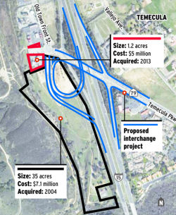 In April 2016, it was reported that the city of Temecula
has pushed back the expected start of construction on a new Temecula
Parkway interchange to late 2016 because of issues involving the
relocation of utilities in the region. The city purchased the AM-PM gas
station to the west of the existing interchange in 2013 to help facilitate
the relocation work – which involves mapping out new routes for
water, power, sewer and gas lines – and hoped to have the $45
million project put out to bid by 2014. The work proved more vexing than
anticipated, but late last year the city said development work could start
in spring 2016. That timeline proved overly optimistic. As of Spring 2016,
Temecula was still updating plans to reflect the proposed alignments of
the various utilities in the region that would be impacted by
construction. When the updates are complete, the city will seek
authorization from both the state Department of Transportation, or
Caltrans, and the Federal Highway Administration. The new configuration
will divide traffic into two separate lines, one that will feed Old Town
to the north and another that will curl around and feed Pechanga Resort
and Casino and communities to the east of the freeway. Currently, the two
streams of motorists often clump together on a single off-ramp regulated
by a traffic signal, which can’t efficiently handle large crowds on
the weekend or during a weekday commute. Most of the money for the project
is in place: more than a million in federal dollars, $14 million from the
Indian Gaming Special Distribution Fund, more than $1 million in county
money and millions more from a regional transportation account that is fed
by development fees. Officials say it will take about 18 months to build.
In April 2016, it was reported that the city of Temecula
has pushed back the expected start of construction on a new Temecula
Parkway interchange to late 2016 because of issues involving the
relocation of utilities in the region. The city purchased the AM-PM gas
station to the west of the existing interchange in 2013 to help facilitate
the relocation work – which involves mapping out new routes for
water, power, sewer and gas lines – and hoped to have the $45
million project put out to bid by 2014. The work proved more vexing than
anticipated, but late last year the city said development work could start
in spring 2016. That timeline proved overly optimistic. As of Spring 2016,
Temecula was still updating plans to reflect the proposed alignments of
the various utilities in the region that would be impacted by
construction. When the updates are complete, the city will seek
authorization from both the state Department of Transportation, or
Caltrans, and the Federal Highway Administration. The new configuration
will divide traffic into two separate lines, one that will feed Old Town
to the north and another that will curl around and feed Pechanga Resort
and Casino and communities to the east of the freeway. Currently, the two
streams of motorists often clump together on a single off-ramp regulated
by a traffic signal, which can’t efficiently handle large crowds on
the weekend or during a weekday commute. Most of the money for the project
is in place: more than a million in federal dollars, $14 million from the
Indian Gaming Special Distribution Fund, more than $1 million in county
money and millions more from a regional transportation account that is fed
by development fees. Officials say it will take about 18 months to build.
(Source: Press-Enterprise, 4/5/2016)
In July 2017, it was reported that construction work will force the closure this week of northbound lanes on I-15 in Temecula and on-ramps and off-ramps at the Temecula Parkway interchange, which is undergoing a dramatic transformation to smooth traffic issues in the southern part of the city. The bulk of the work, which involves roadway excavation for a retaining wall, would occur through Aug. 3, according to a city release.
In June 2018, it was reported that the southbound 15
Freeway on-ramp at Temecula Parkway is complete. Drivers heading toward
San Diego will begin using the new on-ramp near the corner of Temecula
Parkway and Old Town Front Street on Thursday, June 21. The previous
on-ramp will be closed. The new on-ramp is part of the $52 million project
to improve the Temecula Parkway interchange. The project is set to be
finished by the end of 2018.
(Source: Press Enterprise, 6/20/2018)
In November 2018, Caltrans District 8 tweeted about the dedication ceremony for the improved interchanges at Temecula Parkway and I-15.
Temecula Auxiliary Lanes (08-Riv-15 3.5/6.8)
 The 2020 SHOPP, approved in May 2020, included the following NEW Mobility item of
interest: 08-Riverside-15 PM 3.5/6.8 PPNO 3013F Proj ID 0819000031 EA
1K400. I-15 in Temecula, from north of Temecula Parkway to north of
Winchester Road. Construct auxiliary lanes to facilitate merging
movements, rehabilitate lighting, rehabilitate drainage, install
Transportation Management System (TMS) elements, and upgrade guardrail.
Programmed in FY23-24, with construction scheduled to start in May 2024.
Total project cost is $53,659K, with $39,372K being capital (const and
right of way) and $14,287K being support (engineering, environmental,
etc.).
The 2020 SHOPP, approved in May 2020, included the following NEW Mobility item of
interest: 08-Riverside-15 PM 3.5/6.8 PPNO 3013F Proj ID 0819000031 EA
1K400. I-15 in Temecula, from north of Temecula Parkway to north of
Winchester Road. Construct auxiliary lanes to facilitate merging
movements, rehabilitate lighting, rehabilitate drainage, install
Transportation Management System (TMS) elements, and upgrade guardrail.
Programmed in FY23-24, with construction scheduled to start in May 2024.
Total project cost is $53,659K, with $39,372K being capital (const and
right of way) and $14,287K being support (engineering, environmental,
etc.).
(Source: 2020 Approved SHOPP a/o May 2020)
In June 2023, the CTC approved for future consideration
of funding 08-Riv-15, PM R3.5/R6.8. I-15 Temecula Auxiliary Lanes
Project. Construct auxiliary lanes on I-15, in Riverside County.
(MND) (PPNO 3013F) (SHOPP). The project is located on I-15 from postmile
R3.5 to postmile R6.8, in Riverside County. The Department proposes to
construct auxiliary lanes to facilitate merging movements, rehabilitate
lighting and drainage, install TMS elements, and upgrade guardrail. The
project is currently programmed in the 2022 SHOPP for a total of
$53,659,000, which includes Right of Way (Support and Capital) and
Construction (Support and Capital). Construction is estimated to begin
2024-25. The scope, as described for the preferred alternative, is
consistent with the project scope as programmed by the Commission in the
2022 SHOPP. A copy of the MND has been provided to Commission staff. The
project will result in less than significant impacts to the environment
after mitigation. The following resource areas may be impacted by the
project: riparian habitat and jurisdictional waters. Avoidance,
minimization, and mitigation measures will reduce any potential effects to
the environment. These measures include, but are not limited to, the
purchase of re-establishment mitigation bank credits or
permittee-responsible re-establishment and conservation of streambed
resources. As a result, a MND was completed for this project.
(Source: June 2023 CTC Agenda, Agenda Item 2.2c.(1) Item 8)
In June 2023, the CTC amended the following project in
the 2022 SHOPP: 08-Riv-15 3.5/6.8 PPNO 08-3013F; ProjID 0819000031; EA
1K400. I-15 In Temecula, from north of Temecula Parkway to north of
Winchester Road. Construct auxiliary lanes to facilitate merging
movements, rehabilitate lighting, rehabilitate drainage, install
Transportation Management System (TMS) elements, and upgrade guardrail.
Note: Increase R/W capital because of revised costs for offsite
mitigation, permit fees, and positive underground utility verification
work. Decrease construction capital to match updated costs from the
project report. Allocation Changes ($ × 1,000): R/W Cap $70
$120; Const Cap $39,302 $38,251; Total
$53,659 $52,658.
(Source: June 2023 CTC Agenda, Agenda Item 2.1a.(1d) #61)
In June 2023, the CTC approved the following SHOPP
Pre-Construction Phase (environmental support, design, and R/W support)
allocation: $3,976,000. 08-Riv-15 3.5/6.8. PPNO 08-3013F; ProjID
0819000031; EA 1K400. I-15 In Temecula, from north of Temecula Parkway to
north of Winchester Road. Construct auxiliary lanes to facilitate
merging movements, rehabilitate lighting, rehabilitate drainage, install
Transportation Management System (TMS) elements, and upgrade guardrail.
Concurrent consideration of funding under Resolution E-23-87; June 2023.
Concurrent Amendment under SHOPP Amendment 22H-009; June 2023. Allocation
(Programmed / Allocation): PS&E $3,600,000 / $3,900,000;
R/W Sup $69,000 / $76,000.
(Source: June 2023 CTC Agenda, Agenda Item 2.5b.(2a) #14)
In November 2011, the first workshop for the "Historic Highway 395 Corridor Study" project, also known as the Jefferson Avenue Corridor project, was held in Murrieta. The 16-mile arterial corridor is proposed to parallel the west side of I-15 where old US 395 used to travel. It would extend from Rancho California Road (~ RIV 4.989) along Jefferson Avenue through the cities of Temecula and Murrieta, continuing along Palomar Street and Mission Trail through the cities of Wildomar and Lake Elsinore, and continuing along East Lakeshore Drive to Main Street in Lake Elsinore. Additional information may be found at http://www.highway395corridorstudy.org/.
Winchester Road Interchange (~ RIV 6.63)
The SAFETEA-LU act, enacted in August 2005 as the reauthorization of TEA-21, provided the following expenditures on or near this route:
French Valley Parkway Interchange (RIV 6.6/7.6)
In 2007, the CTC did not recommend funding two requests from the Corridor Movement Improvement Account (CMIA): widening I-15 between Bundy Canyon Rd and I-215 ($109,801K) and constructing a new interchange at French Valley Pkwy ($31,545K).
In March 2011, the CTC approved a public road connection at French Valley Parkway on I-15 in the city of Temecula in Riverside County near the city of Temecula, at Post Mile (PM) 7.3. The construction of the French Valley Parkway Interchange would help reduce travel delays by providing increased opportunities for access to and from the mainline facility, thereby alleviating congestion on the adjacent Winchester ramps and traffic that backs up onto the I-15 mainline. However, with the construction of a new interchange and the limited distance between Winchester Road and the I-15/I-215 junction, standard spacing between interchanges is not possible. Without the addition of a collector/distributor (C/D) system, the new interchange would contribute to an increase in weaving movements. To alleviate increased and conflicting weaving movements, a C/D system was incorporated into the project design. To ensure the project meets the Federal Highway Administration (FHWA) criteria for logical termini and independent utility, the effect of the project on the adjacent interchanges and freeway-to-freeway junction was evaluated. The goal was to ensure that the project would not result in adverse operational effects on the mainline or ramps and that the improvements were sufficient to accommodate and safely integrate the traffic volumes being introduced to the mainline facility. Therefore, the improvements were extended to south of the Winchester Road Interchange and north of the I-15/I-215 junction.
A September 2012 article provided more information on the French Valley Parkway. It reported on the purchase of land in late September by the City of Temecula: five separate parcels purchased from Murrieta. The parcels were for the French Valley Parkway project. The total bill for the land is $1.09 million, which includes roughly $15,000 in escrow fees.The $200-million French Valley Parkway interchange project kicked off in June 2012. Split in two phases, the project will add a new exit-only freeway lane at Winchester Road and a westbound off-ramp on southbound I-15, which will take drivers from the freeway to Jefferson Avenue at the Murrieta/Temecula border. The work is expected to take between 12 and 18 months and will cost Temecula $13.8 million, with the bulk of the funds coming from fees developers pay toward capital improvement projects. The second phase will include the construction of the actual parkway stretching over I-15 to Date Street on the east side. Included will be on- and off-ramps, plus new lanes to the outside of the freeway in both directions. The is no start date for the second phase, though the work will take up to 30 months to complete. Murrieta is routing the money from the land purchase toward a project to build a bridge and four-lane road from Ynez Road in Temecula to Jackson Avenue in Murrieta, offering drivers an alternative to the freeway. The thoroughfare will also connect to the later phase of the French Valley Parkway project.
In March 2018, it was reported that the CTC programmed
$47.6 million to the I-15/ French Valley Parkway interchange in Temecula
for construction in FY20-21. PPNO 0021K, In the city of Temecula.
Construct a new French Valley Parkway/Route 15 Overcrossing &
Interchange from just south of the Winchester Rd IC to just north of the
Route 15/Route215 Jct.
(Source: Press Enterprise, 3/23/2018; 2018STIP,
approved at the CTC March 2018 meeting)
In March 2020, the CTC approved the 2020 STIP, which
continued the programmed funding for PPNO 0021K "French Valley Parkway
interchange"
(Source: March 2020 CTC Agenda, Item 4.7, 2020 STIP
Adopted 3/25/2020)
In June 2022, the CTC approved the following STIP
funding allocation: $47,600,000. 08-Riv-15 6.6 6.4/9.7.
PPNO 08-0021K; ProjID 0800020178; EA 43272. French Valley Parkway
Interchange - Collector/Distributor (Phase 2). I-15 In the city of
Temcula. Construct a two lane northbound collector distributor
beginning at I-15/Route 79 Junction and extending just north of I-15/I-215
Junction, with connectors to I-15 and I-215. Contribution from other
sources: $53,378,000. Future consideration of funding approved under
Resolution E-11-18; March 2011. The implementing agency for CONST changed
from the Department of Transportation to City of Temecula. The CON ENG
amount of $6,000,000 was transferred to CONST due to the implementing
agency change for a CONST programmed total of $47,600,000. This allocation
will split out the Child French Valley Parkway Interchange -
Collector/Distributor (Phase 2) Mitigation Project (PPNO 3020E) scope from
the Parent project (PPNO 0221K) and it will fund with local funds. Time
extension for FY 20-21 CONST expires June 30, 2022. ALLOCATION IS
CONTINGENT UPON THE PASSAGE OF THE 2022 BUDGET ACT. Allocation: CON ENG $6,000,000
$0 CONST $41,600,000 $47,600,000.
(Source: June 2022 CTC Agenda, Agenda Item 2.5c.(2)
#2)
In March 2023, it was reported that Flatiron
Construction has kicked off the $71.5 million I-15 French Valley Parkway
Phase II project in Southern California in collaboration with the City of
Temecula. In July 2019, Temecula received a $50 million U.S. Department of
Transportation Infrastructure & Rebuilding America Grant to support
the project. The second of a three-phase improvement plan, this project
calls for constructing collector and distributor lanes along northbound
I-15 from Winchester Road Interchange to the I-15/I-215 Junction. Other
project highlights include construction of a new bridge over the I-215
Freeway, widening two bridges and constructing 40-foot-high retaining
walls. Flatiron completed Phase I of improvement plan in 2013.
(Source: Construction Dive, 3/29/2023)
In January 2013, the CTC authorized $3,500,000 to the RCTC for the I-15/Los Alamos Road Overcrossing Replacement (~ RIV 10.026). This project, in the City of Murrieta, at the intersection of I-15 and the Los Alamos Road overcrossing will replace the existing 2-lane overcrossing with a 4-lane structure.
California Oaks Road Interchange (~ RIV 10.591)
The SAFETEA-LU act, enacted in August 2005 as the reauthorization of TEA-21, provided the following expenditures on or near this route:
In February 2010, the CTC approved for future consideration of funding a project on I-15 in Riverside County to reconfigure the existing California Oaks Road interchange, and construct roadway improvements in the city of Murrieta. (PPNO 9991). Specifically the project will construct roadway improvements that include modifications to an existing diamond interchange on I-15 at California Oaks Road in the city of Murrieta. A Mitigated Negative Declaration (MND) has been completed, because the project will involve construction activities resulting in both visual effects and biological resource impacts in the form of disturbance of burrowing owl habitat.. The project is programmed in the 2008 State Transportation Improvement Program. The total estimated project cost is $36,208,000 for capital and support. Construction is estimated to begin in Fiscal Year 2009-10.
Railroad Canyon Interchange (08-Riv-15, PM 18.3/21.0)
In March 2018, it was reported that the CTC awarded
$2.9 million to the I-15/Railroad Canyon Road interchange in Lake Elsinore
(PPNO 3004U).
(Source: Press Enterprise, 3/23/2018; 2018STIP,
approved at the CTC March 2018 meeting)
In May 2019, the CTC approved for future consideration
of funding 08-Riv-15, PM 18.3/21.0: I-15 in Riverside County. Construct
roadway and interchange improvements on a portion of I-15 in the city of
Lake Elsinore. (PPNO 3004U). This project is located on I-15 at the
Railroad Canyon Road interchange in Lake Elsinore, Riverside County. The
project proposes improvements to the Railroad Canyon Road interchange and
to construct a new interchange north of the existing I-15/Franklin Street
overcrossing (Phases 1 and 2). The proposed project addresses the local
street and freeway ramp congestion issues. The project proposes to
accommodate the projected 2040 traffic flow and movement during morning
and evening peak traffic on I-15 and maintain an acceptable level of
service at this interchange. The project is not fully funded and currently
programmed in the 2018 State Transportation Improvement Program (STIP) for
$2.9 million, local funds for $27.1 million, SB 1 funds for an estimated
$15.0 million and $238,000 in Federal Discretionary funds. The project is
estimated to begin in Fiscal Year 2019-20 for Phase 1.
(Source: May 2019 CTC Minutes, Agenda Item
2.2c.(1))
In December 2019, the CTC had on its agenda a
resolution to approve an allocation of $17,920,000 for the
locally-administered Multi-Funded STIP/SB 1 Local Partnership Program
(LPP) (Competitive) I-15/Railroad Canyon Interchange (PPNO 3004U) project
(08-Riv-15 17.6/19.6 PPNO 3004U Proj ID 0818000047 EA 0A441). On I-15 in
the city of Lake Elsinore in Riverside County. The project will widen the
Railroad Canyon Road under the freeway to eight lanes with dual left turn
lanes to the southbound on-ramp, reconstruct the northbound ramps to a
hook configuration to Grape Street, eliminate the existing northbound exit
ramp and Railroad Canyon Road, construct auxiliary and deceleration lanes
on I-15, and widen the Railroad Canyon southbound exit ramp.
(Source: December 2019 CTC Agenda, Agenda Item
2.5s.(4))
In March 2020, the CTC approved the 2020 STIP, which
continued the programmed funding for PPNO 3004U "Rt 15/Railroad Canyon Rd
interchange"
(Source: March 2020 CTC Agenda, Item 4.7, 2020 STIP
Adopted 3/25/2020)
I-15 Express Lanes (Riverside County - Route 74 to Cajalco Road) (~ RIV 22.242 to RIV 36.791)
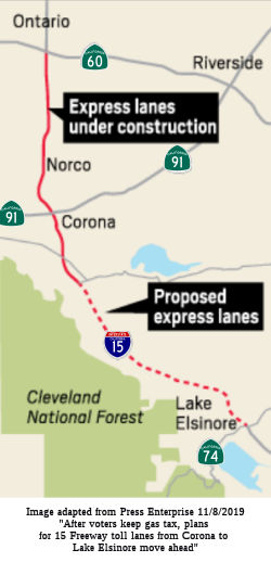 In March 2018, it was reported that the CTC awarded $50 million in state funds to
launch environmental studies that will set the stage for building tolled
express lanes on I-15 between Cajalco Road in Corona and Route 74 in Lake
Elsinore, a news release reports. Those studies are expected to take five
years to complete. The grant is contingent on the recent state gas-tax
increase remaining in place, the news release stated. The project would
extend lanes that are under construction now in a 15-mile segment between
Cajalco Road and Route 60. However, the CTC delayed these studies until
FY22-23.
In March 2018, it was reported that the CTC awarded $50 million in state funds to
launch environmental studies that will set the stage for building tolled
express lanes on I-15 between Cajalco Road in Corona and Route 74 in Lake
Elsinore, a news release reports. Those studies are expected to take five
years to complete. The grant is contingent on the recent state gas-tax
increase remaining in place, the news release stated. The project would
extend lanes that are under construction now in a 15-mile segment between
Cajalco Road and Route 60. However, the CTC delayed these studies until
FY22-23.
(Source: Press Enterprise, 3/23/2018; 2018STIP,
approved at the CTC March 2018 meeting)
In November 2018, it was reported that, with the
approval of the SB1 funding at the November 2018 election, transportation
officials were laying the groundwork to extend the express lanes under
construction on I-15, between Route 60 and Cajalco Road in Corona
(expected to open by mid-2020). The plan is to extend those lanes —
two in each direction — 14 miles farther south to Route 74 in Lake
Elsinore. On Wednesday, Nov. 7, the Riverside County Transportation
Commission announced it’s preparing to do engineering and
environmental studies. The timing was no accident. The notice came one day
after California voters defeated Proposition 6, which would have repealed
last year’s state gas-tax increase — a new source of
transportation funding. The commission made construction of the lanes a
goal in 2006, when it adopted a long-term vision. The development also
boosts efforts of a southwest Riverside County task force that formed in
November 2017 to explore traffic solutions and lobby for toll lanes south
to the San Diego-Riverside county line. Commissioners from southwest
cities will push to make that a goal when the panel meets early in early
2019. As for the environmental studies, the agency anticipates those will
take five years. John Standiford, the commission’s deputy executive
director, said that’s because the 14-mile corridor crosses many
streams and will require widening 14 bridges. Construction could start in
2025 and the lanes could open in 2028. Commuters may get some relief from
the widening from two to four lanes of Temescal Canyon Road, which runs
parallel to I-15. On Tuesday, the Riverside County Board of Supervisors
approved a $13.6 million contract to widen the section between Dawson
Canyon Road and Dos Lagos Drive.
(Source: Press Enterprise, 11/9/2018)
In January 2019, the CTC was informed Caltrans will be
requesting the CTC approve a STIP amendment to authorize the project to
proceed as an Assembly Bill (AB) 3090 replacement arrangement at the next
scheduled Commission meeting following the notice period. The Riverside
County Transportation Commission (RCTC) and the City of Lake Elsinore
propose to amend the 2018 STIP to program an AB 3090 replacement project
(PPNO 3009Y) to advance the start of the Project Approval and
Environmental Document (Environmental) phase of the Interstate 15 (I-15)
Express Lanes – Southern Extension project (PPNO 3009X) by using
local measure funds. The I-15 Express Lanes – Southern Extension
project (PPNO 3009X) will construct approximately 14.5 miles of express
lanes from Cajaico Road in the city of Corona to Route 74 in the city of
Elsinore. Currently $50,000,000 in Regional Improvement Program (RIP)
funding is programmed in fiscal year 2022-23 to the Environmental phase of
the project. During the 2018 STIP cycle, RCTC had requested these RIP
funds to be programmed in 2018-19. However, due to constraints on the
available STIP capacity in the 2018 STIP cycle, the Commission delayed the
programming of these funds to 2022-23. This is a high priority project for
the region. As such, RCTC is proposing to advance the start of the
Environmental phase by using its Local Measure A local funds. This request
follows AB 3090 Guidelines, which allows a local agency to use its own
funds to early deliver a project component programmed in the current STIP
for a future year delivery.
(Source: January 2019 CTC Minutes Agenda Item 2.1b.(2))
In March 2019, the CTC approved Riverside County
Transportation Commission (RCTC) proposal to amend the 2018 STIP to
program an AB 3090 replacement project (PPNO 3009Y) to advance the start
of the Project Approval and Environmental Document (PA&ED) phase of
the Interstate 15 (I-15) Express Lanes – Southern Extension project
(PPNO 3009X) by using local funds.
(Source: March 2019 CTC Minutes Agenda Item 2.1a.(2))
In March 2020, the CTC approved the 2020 STIP, which
moved the funding from PPNO 3009Y to PPNO 0077G, the Route 91/Route 71
interchange and connectors (SB1)
(Source: March 2020 CTC Agenda, Item 4.7, 2020 STIP
Adopted 3/25/2020)
Caljaco Road Interchange (~ RIV 36.791)
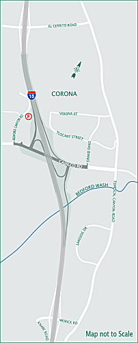 In August 2018, a Construction Alert was posted regarding an ongoing project to construct a
new Cajalco Road Bridge. The City of Corona, in partnership with the
California Department of Transportation (Caltrans), District 8, is
reconstructing the interchange located on I-15 at Cajalco Road from
Temescal Canyon Road to Bedford Canyon Road. The $45 million dollar
investment includes the widening of Cajalco Road from a two-lane bridge to
a six-lane overcrossing bridge on a new alignment north of the existing
bridge. In addition, the bridge will include a striped median, outside
shoulders and a sidewalk on the southern side. The existing northbound and
southbound ramp intersections will be reconfigured and all existing ramps
will be realigned. The existing northbound on-ramp will be modified to
serve the westbound Cajalco Road traffic and a northbound loop on-ramp
will be constructed to serve the eastbound Cajalco Road traffic. The
improvements will increase the capacity of the bridge and ramps in order
to reduce congestion and accommodate projected growth in the area.
Construction began in Early Fall 2017, and expected to be completed in
Late Fall 2019. The Estimated construction cost is $45 Million. It was
noted that the final vertical clearance for the northbound I-15 off-ramp
bridge over the Bedford Wash will be about 8 feet on the east side and
10.5 feet on the west side. The new bridge will be constructed on the N
side of the existing bridge to permit access during construction.
In August 2018, a Construction Alert was posted regarding an ongoing project to construct a
new Cajalco Road Bridge. The City of Corona, in partnership with the
California Department of Transportation (Caltrans), District 8, is
reconstructing the interchange located on I-15 at Cajalco Road from
Temescal Canyon Road to Bedford Canyon Road. The $45 million dollar
investment includes the widening of Cajalco Road from a two-lane bridge to
a six-lane overcrossing bridge on a new alignment north of the existing
bridge. In addition, the bridge will include a striped median, outside
shoulders and a sidewalk on the southern side. The existing northbound and
southbound ramp intersections will be reconfigured and all existing ramps
will be realigned. The existing northbound on-ramp will be modified to
serve the westbound Cajalco Road traffic and a northbound loop on-ramp
will be constructed to serve the eastbound Cajalco Road traffic. The
improvements will increase the capacity of the bridge and ramps in order
to reduce congestion and accommodate projected growth in the area.
Construction began in Early Fall 2017, and expected to be completed in
Late Fall 2019. The Estimated construction cost is $45 Million. It was
noted that the final vertical clearance for the northbound I-15 off-ramp
bridge over the Bedford Wash will be about 8 feet on the east side and
10.5 feet on the west side. The new bridge will be constructed on the N
side of the existing bridge to permit access during construction.
(Source: Caljaco Bridge Construction Website, 11/3/2018)
I-15 Express Lanes (Riverside County - Cajalco Road to Route 60) (~ RIV 36.791 to RIV 51.266)
The SAFETEA-LU act, enacted in August 2005 as the reauthorization of TEA-21, provided the following expenditures on or near this route:
There are plans to add HOT lanes to I-15 once the HOT
construction on Route 91 completes. The Riverside County Transportation
Commission has decided to build four toll lanes -- two in each direction
-- on I-15. Commissioners gave the $415 million follow-up project the
green light in February 2013 at an annual desert retreat. The I-15 toll
lanes would run from Cajalco Road on the south to Route 60 on the north.
Work on the I-15 toll lanes could begin in 2018 and be completed in 2020.
(UT San Diego, 2/8/2013)
In October 2016, it was reported that the Riverside
County Transportation Commission recently marked two big milestones with
the long-planned project to add two toll lanes in each direction on a
14.6-mile stretch of I-15 from Cajalco Road in Corona to Route 60 at the
San Bernardino County line. First, the agency approved a 50-year agreement
with Caltrans for the right to operate toll lanes on the freeway.
Secondly, in July 2016, it approved an environmental document that clears
the way to move forward with construction. The commission has also begun
searching for a toll operations office where staff will manage the
corridor and provide customer service. A contract for the $450 million
project is expected to be awarded by summer 2017 with construction to
begin soon after. The agency plans to use a design-build process which
allows officials to contract with one firm for the whole project and save
time. The project will be integrated with the Route 91 Express Lanes, so
that, when completed, commuters taking the toll lanes northbound on I-15
can continue seamlessly on a connector to the Route 91 toll lanes that go
into Orange County. Riverside County also has future plans to extend the
toll lanes farther south to Route 74 in Lake Elsinore although that
project is several years away.
(Source: Press Enterprise, 10/3/2016)
Additionally, in October 2016, the CTC approved for future consideration of funding a project in Riverside County on a portion of I-15 in the cities of Norco, Eastvale, and Jurupa Valley that will construct two tolled express lanes. The project is fully funded with local funds. The project is included in the Design-Build program. The total estimated cost is $450,000,000 for capital and support. Construction is estimated to begin in Fiscal Year 2018-19.
In April 2017, it was reported that construction is set
to start early in 2018 on a 14.6-mile toll lane on I-15, from the Temescal
Valley, south of Corona, north to Jurupa Valley. The I-15 lanes, which
will run from Cajalco Road to just south of Route 60, are a natural
follow-up to work on the Route 91, which opened March 20 after three years
of construction, Riverside County Transportation Commission officials
said. The $450 million project will add two toll lanes in each direction
to the freeway, which now has three lanes each way from Cajalco Road to
Route 60. The new lanes will be built on the existing median. In early
April 2017, the commission awarded a contract to Skanska-Ames. The agency
plans to speed up construction by having the same team handle the
project’s design and construction. The firm should be ready to begin
construction by early 2018 with the new lanes completed by 2020, said John
Standiford, the commission’s deputy executive director.
(Source: Press Enterprise, 4/19/2017)
In July 2017, it was reported that plans to build toll
lanes on I-15 from south of Corona to Jurupa Valley have received a major
boost with the approval of a $152 million federal loan. The money from the
United States Department of Transportation approved this month was the
final piece of financing and clears the way for the Riverside County
Transportation Commission to start construction of the 15-mile project
early next year. The $471 million project will add two toll lanes in each
direction to the freeway, which now has three lanes each way from Cajalco
Road north to Route 60. The new lanes are expected to open in 2020. The
commission’s application for the low-interest loan through the
Transportation Infrastructure Finance and Innovation Act was a
competitive, months-long, process. Under federal law, the program can only
finance a third of a project’s cost. The rest will be financed
through bonds and borrowing from the county’s Measure A sales tax.
Future toll proceeds will repay the loans and pay for maintenance and
operation of the toll lanes. Under federal law, the program can only
finance a third of a project’s cost. The rest will be financed
through bonds and borrowing from the county’s Measure A sales tax.
Future toll proceeds will repay the loans and pay for maintenance and
operation of the toll lanes.
(Source: Press Enterprise, 7/30/2017)
In May 2018, it was reported that the Riverside County
Transportation Commission approved in a near-unanimous vote lengthening by
one mile the northbound I-15 toll lanes — which begin at Ontario
Avenue now — and creating a continuous lane for entering and exiting
the Route 91 toll lanes at the Riverside-Orange county line (these would
now start around Foothill Parkway).
(Source: Press Enterprise, 5/9/2018)
In February 2019, the RCTC provided an update on the work on the 15 Express Lanes. According to the RCTC, work is now about one-third complete. The new lanes will span 15 miles – from Cajalco Road to Route 60 – and remain on schedule to open in 2020. A specific opening date has not been determined at this time. Along the corridor, paving, bridge widening, and soundwall construction are continuing. Major milestones include:
The project team continues to coordinate with the
neighboring Limonite Avenue Interchange Project, led by the County of
Riverside, and the Cajalco Road Interchange Project, led by the City of
Corona. Teams are working closely and to ensure that all three projects to
stay on schedule. A robust construction schedule is planned for 2019, with
more roadway paving, continued widening of bridges, and installing the
tolling system infrastructure. Once the lanes are closer to completion,
information will be available about the opening date, toll schedules, and
account options
(Source: RCTC, 2/21/2019)
In June 2019, it was reported that paving has been
completed north of the Santa Ana River and is well underway to the south.
Sound walls have been built in several places. In June, crews were using
30-foot-tall, 56-foot-wide, cranes to set forms in place to pour
steel-reinforced concrete pier walls to anchor a new bridge over the Santa
Ana River, in between the northbound and southbound lanes; they would then
set 170-foot-long concrete girders on top of the pier walls to support the
new 0.35-mile-long bridge over the Santa Ana River. Launched in April
2018, the express-lanes project is on schedule and expected to open in the
second half of 2020, said John Standiford, deputy executive director for
the road-building agency. Access will be provided at Weirick Road, Cajalco
Road, Ontario Avenue, Magnolia Avenue, Hidden Valley Parkway, Second
Street/Sixth Street, Limonite Avenue, Cantu-Galleano Ranch Road and just
south of the 60 Freeway, agency plans show. Unlike the San Diego area,
where there are five “direct access ramps” that drop commuters
and buses right into the express lanes from side streets, drivers will
have to merge into the special lanes through periodic, signed openings
from all-purpose lanes on I-15. Additionally, instead of setting tolls
based on time of day as is done on Route 91, the county transportation
commission intends to adjust I-15 HOT tolls every 15 minutes or so based
on the traffic volume.
(Source: Press Enterprise, 6/25/2019)
In May 2021, it was reported that Riverside
County’s 15 Express Lanes are now open, giving motorists a
convenient new way to travel. The new toll lanes extend 15 miles from
Route 60 to Cajalco Road in Corona. During the initial months of
operation, carpools of three or more people can ride free. After that,
they can ride at half price. A transponder set to “3” is
required.
(Source: Metro "On The Go" Newsletter, May 2021)
Ontario Avenue Deceleration Lane (08-Riv-15 38.95/39.4)
In December 2023, it was reported that Caltrans will
move forward with reconfiguring a half-mile segment of I-15 in Corona to
facilitate safe flows of traffic onto a freeway exit. Assemblyman Bill
Essayli, R-Norco, said that months of negotiations between his office and
Caltrans officials had netted a positive outcome in the form of a $6
million project to add a "deceleration lane" to southbound I-15 between
Old Temescal Road and East Ontario Avenue. The lawmaker first contacted
Caltrans Director Tony Tavares in March regarding the need for changes
along the heavily traveled corridor, characterizing I-15 generally as
replete with "soul-crushing traffic congestion" during peak travel
periods. The segment designated for modification lacks a separate lane
where motorists can queue up to exit the freeway, resulting in snarled
conditions when southbound commuters are packed onto the artery.
(Source: Lake Elsinore Patch, 12/7/2023)
In December 2023, the CTC approved the following
amendment to a project in the 2022 SHOPP: 08-Riv-15 38.95/39.4. PPNO
08-3021L; ProjID 0823000025; EA 1N610. Route 15 Near Corona, from 0.3 mile
to 0.7 mile north of Ontario Avenue. Construct deceleration lane
prior to southbound Ontario Avenue offramp. Concurrent COS allocation
under Resolution FP-23-55; December 2023. Allocation ($ × $1000)
PA&ED $2,138; PS&E $2,095; R/W Sup $183; Con Sup $2,544; R/W Cap
$23; Const Cap $7,652; TOTAL $14,635. FY25-26 BC: 12/7/2026.
(Source: December 2023 CTC Agenda, Agenda Item 2.1a.(2a) #1)
In December 2023, the CTC approved the following SHOPP
preconstruction-phase allocation:.$2,138,000. 08-Riv-15 38.95/39.4. PPNO
08-3021L; ProjID 0823000025; EA 1N610. Route 15 Near Corona, from 0.3 mile
to 0.7 mile north of Ontario Avenue. Construct deceleration lane prior to
southbound Ontario Avenue offramp. Concurrent Amendment under SHOPP
Amendment 22H-015; December 2023. Programmed (Allocation, if
different): PA&ED $2,138,000.
(Source: December 2023 CTC Agenda, Agenda Item 2.5b.(3) #2)
Limonite Avenue Interchange (RIV 46.7/49.7)
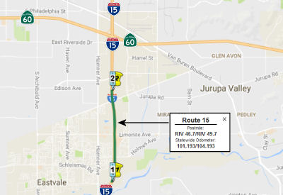 In August 2017, the CTC approved for future consideration
of funding 08-Riv-15, PM 46.7/49.7 I-15/Limonite Avenue Interchange
Improvements Project: This project in Riverside County will widen the
interchange and the on/off ramps at the I-15/Limonite Avenue interchange
in the cities of Eastvale and Jurupa Valley. The project is not fully
funded. The estimated project cost is $59.5 million. $11 million funding
is proposed from local measure funds and $48.5 million to be determined.
Construction is estimated to begin in 2018. A copy of the MND has been
provided to Commission staff. The project will result in less than
significant impacts to the environment after mitigation. The following
resource area may be impacted by the project: paleontological resources.
Avoidance and minimization measures will reduce any potential effects on
the environment. These measures include, but are not limited to, a
paleontological monitor shall be on-site during construction, and a
qualified paleontologist shall attend preconstruction meetings to consult
with the grading and excavation contractors. As a result, an MND was
completed for this project.
In August 2017, the CTC approved for future consideration
of funding 08-Riv-15, PM 46.7/49.7 I-15/Limonite Avenue Interchange
Improvements Project: This project in Riverside County will widen the
interchange and the on/off ramps at the I-15/Limonite Avenue interchange
in the cities of Eastvale and Jurupa Valley. The project is not fully
funded. The estimated project cost is $59.5 million. $11 million funding
is proposed from local measure funds and $48.5 million to be determined.
Construction is estimated to begin in 2018. A copy of the MND has been
provided to Commission staff. The project will result in less than
significant impacts to the environment after mitigation. The following
resource area may be impacted by the project: paleontological resources.
Avoidance and minimization measures will reduce any potential effects on
the environment. These measures include, but are not limited to, a
paleontological monitor shall be on-site during construction, and a
qualified paleontologist shall attend preconstruction meetings to consult
with the grading and excavation contractors. As a result, an MND was
completed for this project.
In October 2017, it was reported that the passage of
SB1 should speed up this project. Projects funded by SB1 include $48
million for a rebuilt I-15/Limonite Avenue interchange serving Eastvale
and Jurupa Valley and $180 million for a connector ramp between the new
Route 91 express lanes and northbound I-15 in Corona.
(Source: Press Enterprise, 10/13/2017)
Interstate 15 Corridor Freight Improvement Project: Auxiliary Lanes and Express Lanes - Route 60 to I-210 (08-Riv-15, PM 49.8/52.3, 08-SBd-15, PM 0.0/12.2)
 The Interstate 15 (I-15) Corridor Freight Improvement Project: Auxiliary Lanes
and Express Lanes is a collaborative effort by SBCTA, RCTC and Caltrans to
improve traffic efficiency, operations, and safety at a
nationally-significant freight bottleneck. The segment extends from
Cantu-Galleano Ranch Road in Riverside County to Foothill Boulevard in San
Bernardino County, with the I-15/I-10 interchange in the mid-section, a
critical bottleneck for freight. This section of I-15 crosses two major
east-west freight corridors, Route 60 and I-10. Auxiliary lanes will be
added in three strategic locations to increase throughput for trucks and
enhance traffic operations and safety. Also included are express lanes in
the median of I-15 (where there are no current HOV lanes), matching the
express lanes currently under construction in Riverside County.
Collaboration has been ongoing and continues with RCTC to develop and fund
a project that complements the RCTC I-15 express lanes and aims to provide
a consistent, seamless service for the traveling public.
The Interstate 15 (I-15) Corridor Freight Improvement Project: Auxiliary Lanes
and Express Lanes is a collaborative effort by SBCTA, RCTC and Caltrans to
improve traffic efficiency, operations, and safety at a
nationally-significant freight bottleneck. The segment extends from
Cantu-Galleano Ranch Road in Riverside County to Foothill Boulevard in San
Bernardino County, with the I-15/I-10 interchange in the mid-section, a
critical bottleneck for freight. This section of I-15 crosses two major
east-west freight corridors, Route 60 and I-10. Auxiliary lanes will be
added in three strategic locations to increase throughput for trucks and
enhance traffic operations and safety. Also included are express lanes in
the median of I-15 (where there are no current HOV lanes), matching the
express lanes currently under construction in Riverside County.
Collaboration has been ongoing and continues with RCTC to develop and fund
a project that complements the RCTC I-15 express lanes and aims to provide
a consistent, seamless service for the traveling public.
(Source: I-15 Freight Corridor Improvement Project Fact Sheet; Image source: Initial Study with Mitigated Negative Declaration/Environmental Assessment
with Finding of No Significant Impact, 12/2018)
The project would add two Express Lanes in each
direction between Route 60 and Route 210 , one Express Lane in each
direction between Cantu-Galleano Ranch Road and Route 60 and one Express
Lane in each direction between Route 210 and Duncan Canyon Road. This
project also proposes to add one Auxiliary Lane in each direction between
Route 60 and I-10 and one Auxiliary Lane in the northbound (NB) direction
between Fourth Street and Foothill Boulevard. The proposed project extends
through three freeway-to-freeway system interchanges, including Route 60
in the cities of Eastvale and Jurupa Valley in Riverside County, I-10 in
the City of Ontario in San Bernardino County, and Route 210 in the cities
of Rancho Cucamonga and Fontana in San Bernardino County. Express
Lane advance signage is required a minimum of two miles prior to the start
of the Express Lanes. The limits for the planned advance signage at the
southerly end extend approximately 1.3 miles south of the CantuGalleano
Ranch Road Overcrossing (at Post Mile 48.9) and at the northerly end
extend approximately 1.6 miles north of the Duncan Canyon Road
Overcrossing (at Post Mile 12.6); these constitute the advance signage
limits associated with the I-15 Corridor project. In parallel, the
Riverside County Transportation Commission (RCTC) has proposed
improvements on an adjoining portion of I-15, identified as the I-15
Tolled Express Lanes (I-15 TEL) project (08-0J0800), which would
includeconstruction of two TEL in each direction from Hidden Valley
Parkway, in Norco, to Cantu-Galleano Ranch Road in Eastvale and Jurupa
Valley and one TEL in each direction from Cantu-Galleano Ranch Road to
SR-60, in Eastvale and Jurupa Valley from Hidden Valley Parkway, in Norco,
to end of SR-91 TEL, in Corona, and from El Cerrito Road to Cajalco Road
in Corona. The SBCTA proposed I-15 CP, which would add one Express Lane in
each direction between Cantu-Galleano Ranch Road and SR-60 at the
southerly end, provides continuity of two Express Lanes in each direction
between RCTC’s I-15 TEL project and SBCTA’s I-15 CP.
(Source: Initial Study with Mitigated Negative Declaration/Environmental Assessment with Finding of No Significant Impact, 12/2018)
In March 2019, the CTC approved for future
consideration of funding a project located on I-15 in the cities of
Eastvale and Jurupa Valley in Riverside County and the city of Jurupa
Valley in San Bernardino County (08-Riv-15, PM 49.8/52.3, 08-SBd-15, PM
0.0/12.2). The project proposes to add two Express Lanes in each direction
on I-15 between Route 60 and Route 210, and add one Express Lane in each
direction on I-15 between Cantu-Galleano Ranch Road and Route 60 in
Riverside County and between Route 210 and Duncan Canyon Road in San
Bernardino County. The proposed project will also add auxiliary lanes and
reconstruct and/or modify existing onramps. The project proposes to
address the increase in traffic demand and insufficient road capacity due
to lack of available travel mobility options. This project is currently
programmed in the San Bernardino County Transportation Authority Freeway
Program. This project proposes to be funded by Local Measure I funds and
Toll Revenue Bonds. Construction is estimated to begin in 2021.
(Source: March 2019 CTC Minutes, Agenda Item 2.2c.(1))
In August 2022, the CTC amended the Local Partnership
Formulaic Program to add the I-15 Corridor Freight Improvement: Auxiliary
Lanes and Express Lanes Project in San Bernardino County and program
$11,554,000 of their 2020 Formulaic Program funding to the Construction
phase in Fiscal Year 2022-23. This project will add auxiliary lanes and
express lanes on I-15 at critical freight bottlenecks. The anticipated
benefits of this project include improving freight efficiency, traffic
operations, and safety at a freight bottleneck on a nationally significant
freight route.
(Source: October 2022 CTC Agenda, Agenda Item 4.27)
In October 2023, the CTC approved for consideration of
funding the following project for which a MND and an Addendum have been
completed: I-15 in Riverside and San Bernadino Counties. Construct express
lanes by adding 2 express lanes and 1 auxiliary lane with price
managed/toll facilities on I-15, in Riverside and San Bernadino Counties.
(08-Riv-15, PM 48.9/52.3; 08-SBd-15, PM 0.0/7.4; PPNO 0167M). The project
is currently programmed in the 2022 STIP for a total of $319,636,000,
which includes Right of Way (Capital) and Construction (Capital).
Construction began in 2023-24. The scope, as described for the preferred
alternative, is consistent with the project scope as programmed by the
Commission in the 2022 STIP. A copy of the MND has been provided to
Commission staff. The Commission approved the project for future
consideration of funding on March 14, 2019, under Resolution E-19-24.
Since the approval of the MND, there have been changes to the project and
an Addendum was prepared pursuant to CEQA. These changes include
modifications to sound barriers, and limits of disturbance, refinements to
geometry at off-ramps, the addition of a 300-foot express auxiliary lane
on southbound I-15, and the addition of a second lane on the I-15
southbound 4th Street off-ramp. There have also been
refinements to the impacts to jurisdictional waters and the mitigation
associated with these features. The project would not result in
substantial increases in the severity of significant effects, would not
involve substantial changes in regulatory circumstances, did not
identify new alternatives, and proposed similar avoidance, minimization,
and mitigation measures when compared to the MND. The project changes do
not meet the criteria outlined in CEQA Guidelines Section 15162 to prepare
a Subsequent MND. The Department subsequently completed an Addendum to the
MND pursuant to CEQA. The Department has approved this project for
construction. This approval and the Addendum will satisfy the
environmental requirements for this stage of the planning process.
(Source: October 2023 CTC Agenda, Agenda Item 2.2c.(4))
In December 2023, the CTC failed to approve a
request of $202,567,000 for the locally-administered multi-funded
TCEP/LPP (Formulaic)/STIP I-15 Corridor Freight Improvement Project:
Auxiliary Lanes and Express Lanes - Construction project: 08-Riv/SBd-15 49.80
48.90/52.30 0.00/6.30 7.40. PPNO
08-0167M; ProjID 0820000075; EA 0R801. Interstate 15 Corridor Freight
Improvement Project: Auxiliary Lanes and Express Lanes - Construction.
In San Bernardino and Riverside Counties through the cities of Eastvale,
Jurupa Valley, Ontario, and Rancho Cucamonga, on I-15 from Cantu-Galleano
Road to Foothill Boulevard, construct auxiliary lanes and express lanes.
An auxiliary lane will be added in the northbound direction from just
south of Jurupa Street extending north to tie into existing auxiliary
lanes north of Jurupa Street (1.21 miles). An additional northbound
auxiliary lane will be added from just north of 4th Street to just south
of Foothill Boulevard (1.6 miles). A new auxiliary lane will be added in
the southbound direction from just south of the I-10/I-15 interchange to
the Riverside County Line (2.05 miles). Express lanes will extend
northerly from Cantu-Galleano Ranch Road/Route 60 to Foothill Boulevard.
Express lanes will be constructed in the median of I-15 joining the
Express Lanes in Riverside County. CEQA - MND, 12/20/2018; Re-validation
07/16/2023. NEPA - FONSI, 12/20/2018; Re-validation 07/16/2023. Right of
Way Certification: 10/27/2023. Future consideration of funding approved
under Resolution E-23-135A; October 2023. Contribution from other sources:
$126,145,000. Time extension for FY 22-23 CONST expires on April 30, 2024.
As part of this allocation request, the Agency is requesting to extend the
completion of CON an additional 12 months beyond the 36 month deadline.
Commission staff recommended approval of a minor scope change on
10/20/2023. This minor scope change with associated cost and schedule
changes, and does not reduce project benefits or outcomes. Commission
staff recommended approval to remove additional outputs on
11/16/2023. The additional outputs will be delivered as part of PPNO
3017N (Interstate 15 Corridor Freight Improvement Project: Toll System
Provider (D/B Contract)), which are tolling system infrastructure
necessary for the construction of HOT lanes. Change to the outputs and to
add additional outputs information note made via the Yellow Revised
distributed at the December 2023 CTC meeting.
(Source: December 2023 CTC Agenda, Agenda Item 2.5s.(5))
Streetsblog LA provided more details on the
disapproval. According to them:
(Source: Streetsblog LA, 12/14/2023)
"The project in question should have been just another in [the approval] list: the I-15 Freight Corridor Improvement project in San Bernardino and Riverside Counties was asking for an allocation of some $200 million. It has cleared the environmental process, is receiving funding from multiple sources, is programmed into the State Transportation Improvement Program, has begun construction, and had been approved for future consideration of funding by the CTC in October, at the same time as a pile of other projects. The project adds auxiliary lanes and express lanes with "price managed/toll facilities" to the I-15. But Commissioner Joseph Lyou, who is also Executive Director of the Coalition for Clean Air, had questions. "This project adds 31.9 new lane miles to I-15 in a very congested corridor where there are a lot of problems," he said. "The initial study estimates that an additional 300 million vehicle miles traveled (VMT) annually will result. The NCST's VMT calculator only came up with about 152 million additional VMT - but whichever one you use, it's a whole lot of added VMT." [...] "And despite that, at every meeting, we are asked to make one or two exceptions to this, and we widen freeway project after freeway project," he added. "As someone who believes that we need to do what we say and say what we do, it gets pretty frustrating." It is rare enough for a California Transportation Commissioner to address the insanity of repeating our mistakes over and over; but Lyou wasn't alone. Commissioner Darnell Grisby agreed with him, and asked him for a quick summary of the issues he had found. "One of my chief concerns is the way analyses are done," said Lyou. "While we're putting passenger vehicles and light duty trucks onto express lanes, we're then creating more capacity for trucks to go on those lanes, but the [environmental analysis assumes] that there will be no more trucks. In a place like the Inland Empire, where warehouses pop up every day - million-square-foot warehouses - I do think that providing that capacity on that freeway will influence whether we get more million-square-foot warehouses. And it will and can induce truck traffic. Those truck impacts are ignored, allowing [the project] to bypass the transportation conformity hot spots analysis under the Clean Air Act." He pointed out that the CEQA analysis also sidesteps Caltrans' own rules under S.B. 743 - nothing new to Streetsblog readers. But it was running late and the agenda wasn't getting any shorter, so he left out the details. Commissioner Hilary Norton moved to approve the item, with a request for a report on how the extra driving would be mitigated. But some commissioners had already left, and three "no" votes from Commissioners Lyou, Grisby, and Adonia Lugo were enough to leave the project on the table. That doesn't mean it won't be approved in the future; it will come back for more discussion at a future meeting. Meanwhile, though, highway builders should understand they are on notice. Their strategies for ignoring environmental and climate laws - like their reasoning that "auxiliary lanes" are not adding capacity, that they do not have to count truck traffic, or that "adding capacity will reduce congestion and pollution" - are running awfully thin, and fewer people are willing to just accept them without question.
In January 2024, the CTC approved the following
allocation: $202,567,000. 08-Riv/SBd-15 49.80 48.90/52.30
0.00/6.30 7.40. PPNO 08-0167M; ProjID 0820000075;
EA 0R801. Interstate 15 Corridor Freight Improvement Project:
Auxiliary Lanes and Express Lanes - Construction. In San Bernardino and
Riverside Counties through the cities of Eastvale, Jurupa Valley, Ontario,
and Rancho Cucamonga, on I-15 from Cantu-Galleano Road to Foothill
Boulevard, construct auxiliary lanes and express lanes. An auxiliary lane
will be added in the northbound direction from just south of Jurupa Street
extending north to tie into existing auxiliary lanes north of Jurupa
Street (1.21 miles). An additional northbound auxiliary lane will be added
from just north of 4th Street to just south of Foothill Boulevard (1.6
miles). A new auxiliary lane will be added in the southbound direction
from just south of the I-10/I-15 interchange to the Riverside County Line
(2.05 miles). Express lanes will extend northerly from Cantu-Galleano
Ranch Road/SR-60 to Foothill Boulevard. Express lanes will be constructed
in the median of I-15 joining the Express Lanes in Riverside County. CEQA
- MND, 12/20/2018; Re-validation 07/16/2023. NEPA - FONSI, 12/20/2018;
Re-validation 07/16/2023. Right of Way Certification: 10/27/2023. Future
consideration of funding approved under Resolution E-19-24; March 2019.
Addendum for the previously approved Future Consideration of Funding
approved under Resolution E-23-135A; October 2023. Contribution from other
sources: $126,145,000.
Time extension for FY 22-23 CONST expires on April 30, 2024. As part of
this allocation request, the Agency is requesting to extend the completion
of CONST an additional 12 months beyond the 36 month deadline. Commission
staff recommended approval of a minor scope change on 10/20/2023. This
minor scope change with associated cost and schedule changes, and does not
reduce project benefits or outcomes. Tolling infrastructure related to
this scope will be constructed separately under PPNO 3017N. Allocation:
Programmed (Allocated): CONST $52,200,000 TCEP-R/22-23
+ $66,539,000 TCEP-S/22-23 + $11,554,000 LPP-F/22-23
+ $72,274,000 RIP/22-23 = $202,567,000.
(Source: January CTC Meeting, Agenda Item 2.5s.(5))
In light of the rejection at the December 2023 CTC
meeting, the January 2024 CTC meeting was contentious. At the meeting,
dozens of hard-hat-wearing union construction workers held signs like
“Roads, Roads, Roads” to make the case for new jobs. The San
Bernardino County Transportation Authority (SBCTA) opened with a
presentation about the project explaining how the new express lanes tie
into another toll lane completed in Riverside County and fit into the
larger regional plan that extends deep into Orange County. The
lanes’ northern end would be near the terminus of the future
Brightline project, a planned high-speed rail line from Rancho Cucamonga
to Las Vegas. The SBCTA argued that traffic at the port complex continues
to grow, and the region needs the infrastructure inland that accommodates
it. Public testimony on both sides stretched nearly two hours. On the pro
side: The project would provide well-paying jobs, ease congestion and
complement rail transportation projects in the works. On the con side:
Asthma would get worse, and more warehouses would loom over neighborhoods
and bring even more traffic. The commissioners then limited themselves to
2 minute speeches, the same as public speakers. This created a problem for
Joseph Lyou, who in December was a member of the CTC who raised the
environmental concerns that tabled the issue in December. Lyou is
president of the Coalition for Clean Air and a former board member of the
South Coast Air Quality Management District. He said he was “at the
end of his patience” with traffic-inducing freeway expansions that
California officials had pledged to end to meet ambitious climate goals.
He had investigated the issue in the past, and believed Caltrans and the
SBCTA misled federal regulators to bypass environmental reviews that
quantify the potential pollution from a project and force it to be offset.
The time limitation forced Lyou to condense a 53-page presentation. He
pointed out the discrepancy in the two different findings, saying that the
SBCTA and Caltrans can’t say there won’t be more truck traffic
to the working group, which enforces the Clean Air Act, and then ask the
state for money to improve freight movement that it says will increase
truck traffic. He moved that the commission suspend the vote and force
Caltrans and the SBCTA to explain “what the heck is going on.”
The SBCTA defended the statements, saying they came from two different
analyses and each had its own purpose. Eventually, the allocation was
approved (and Lyou was replaced on the commission).
(Source: Los Angeles Times, 2/5/2024)
Near Rancho Cucamonga and Ontario, there are a series of signs that read things like "BLUE AND ORANGE PASS USE I-210" then "TAN AND GREEN PASS USE I-10" and "RED PASS USE 4th ST EXIT." These refer to parking directions for the California Speedway. (~ SBD 3.099)
In August 2011, the CTC approved $108,745,000 in SHOPP funding for repairs in Rancho Cucamonga, Fontana and Rialto from 7th Street to Sierra Avenue (~ SBD 3.926 to SBD 12.925) that will rehabilitate 41 lane miles of pavement, replace barriers on five bridges, remove and replace approach and departure slabs on 11 bridges and seal decks on three bridges to improve safety and ride quality.
Base Line Road Interchange (~ SBD 6.818)
The SAFETEA-LU act, enacted in August 2005 as the reauthorization of TEA-21, provided the following expenditures on or near this route:
In December 2011, the CTC approved for future consideration of funding a project in San Bernardino County that will improve the I-15/Base Line Road Interchange in Rancho Cucamonga, including widening Base Line Road from four to six lanes, widening East Avenue from two to four lanes, adding right and left turn lanes on Base Line Road and on East Avenue, realigning and widening the southbound and northbound diamond ramps from one to two lanes, adding a southbound loop on-ramp, and adding I-15 acceleration/deceleration lanes. The project is programmed in the Proposition 1B State-Local Partnership Program (SLPP) and includes local funds. The total estimated project cost is $43,100,000 for capital and support. Construction is estimated to begin in Fiscal Year 2011- 12. The scope, as described for the preferred alternative, is consistent with the project scope programmed by the Commission in the SLPP. A copy of the MND has been provided to Commission staff. The project will mitigate potential impacts to wetlands and other waters to a less than significant level. Potential impacts to wetlands will be mitigated through the purchase of mitigation credits from an off-site mitigation bank or participation in an in-lieu fee program.
Duncan Canyon Road Overcrossing (~ SBD 11.049)
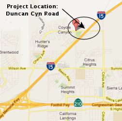 In March 2012, the CTC approved for future consideration of funding a project
that will construct a new interchange on I-15 at the existing Duncan
Canyon Road overcrossing in the City of Fontana. The project is programmed
in the State-Local Partnership Program (SLPP). The project is fully funded
with SLPP and local funds. Construction is estimated to begin in Fiscal
Year 2011-12. The total estimated project cost is $31,752,000 for capital
and support. The scope, as described for the preferred alternative, is
consistent with the project scope programmed by the Commission in the
SLPP.
In March 2012, the CTC approved for future consideration of funding a project
that will construct a new interchange on I-15 at the existing Duncan
Canyon Road overcrossing in the City of Fontana. The project is programmed
in the State-Local Partnership Program (SLPP). The project is fully funded
with SLPP and local funds. Construction is estimated to begin in Fiscal
Year 2011-12. The total estimated project cost is $31,752,000 for capital
and support. The scope, as described for the preferred alternative, is
consistent with the project scope programmed by the Commission in the
SLPP.
In June 2012, the CTC approved a new interchange on I-15 within the City of Fontana. The interchange is to be located at the existing Duncan Canyon Road Overcrossing. The new interchange is between the existing Summit Avenue Interchange (PM 9.60) to the south and Sierra Avenue Interchange (PM 12.84) to the north. The Duncan Canyon Road Interchange has been initiated by the City to address the need for additional access to I-15. The project is necessitated in response to the traffic volume increases which will result from the rapid growth in both population and industrial development projected over the next 25 years. This project proposes providing a freeway access ramp at the four quadrants of the interchange. The exit ramp termini would be designed for three lanes to ensure a satisfactory Level of Service. The northbound entrance ramp would have a single mixed flow lane and an HOV lane and the southbound entrance ramp would have two mixed flow lanes and an HOV lane. The entrance ramps would be metered. Deceleration and acceleration lanes would be provided on the northbound exit ramp and southbound entrance ramp respectively. Duncan Canyon Road, including the existing overcrossing structure, is proposed to be widened to the north to match the standard cross section in the City's General Plan. This standard cross section for Duncan Canyon Road is classified by the City as a modified primary highway. The existing twolane Duncan Canyon Road to the west of the overcrossing would be widened to four lanes which match recent improvements. At the overcrossing structure, aside from the proposed four through lanes, there would be two dedicated left turn lanes for westbound Duncan Canyon Road traffic turning onto the southbound I-15 entrance ramp. A single left turn lane will be used for eastbound Duncan Canyon Road to the southbound I-15 entrance ramp. A six-foot sidewalk is proposed along the north and south sides of the overcrossing along with an eight-foot Class II bike lane/shoulder. In December 2012, the CTC updated the funding plan for this project.
In December 2016, it was reported that Caltrans will
install two box culverts under I-15 as part of the Duncan Canyon Road
Interchange Project. The master planned storm drain facility was combined
with the Duncan Canyon Road Interchange Project to minimize impacts to
motorists on the freeway mainline. The $3 million project was awarded to
SEMA Construction, Inc. in late September 2016.
(Source: Caltrans News Release, 12/16/2016)
In January 2023, the CTC authorized relinquishment of right of way
consisting of collateral facilities to the County of San Bernardino along
Route 15 on Cajon Boulevard and along Route 215 on Cajon Boulevard, Cajon
Court, Devore Road, and Nedlee Avenue (08-SBd-15-PM R13.81/R14.40 and
08-SBd-215-PM 17.05/17.55, 6 segments). The County, by freeway agreement
dated August 21, 2012, agreed to accept the relinquishment and by County
Resolution 2022-207 agreed to waive the 90-day notice and accept title
upon relinquishment by the State.
(Source: January 2023 CTC Agenda, Agenda Item 2.3c)
Devore Interchange Project (~ SBD 14.773/14.982)
According to Chris Powell, there are also plans to widen the freeway between I-210 and the Mojave River in Apple Valley. This won't happen for another 10-12 years, but in the plans there are also plans to redesign the I-15/I-215 interchange in Devore. The redesign would make it so that the I-15 becomes the mainline instead of the I-215 like it does now. In other words the I-215 would merge with the I-15 in the slow lane rather then having the I-15 merge with the I-215 in the slow lane like it does now. There were five alternatives: a no build alternative, a TSM/TDM alternative, adding HOV lanes, dedicated truck lanes from the 210 to the Mojave River, and a managed lanes alternative that would put reversible lanes in the median of the I-15 for rush hour traffic going both directions. Out of the five there were two alternatives that are going to be studied further. One of the ideas is a mix of the 3rd and 5th alternative that would put reverisible lanes from north of US 395 to I-210, which would include also adding mixed flow lanes from I-210 to US 395. The other alternative is the dedicated truck lanes that would run in the median of I-15. Also this alternative has two different possibilities that are going to be looked at: (1) to have just exclusive truck lanes with no tolls for the trucks, or (2) to have a toll lane for LCV's (which would require extending the lanes into Nevada to work).
In June 2012, the CTC approved for future consideration of funding a project that will reconstruct the I-15/I-215 Interchange adjacent to the unincorporated Community of Devore in southwestern San Bernardino County. The project will include the widening of I-15, constructing truck bypass lanes through the I-15/I-215 Interchange, reconstructing adjacent local interchanges, and reconnecting Cajon Boulevard between Devore Road and Kenwood Avenue. The project is programmed in the 2012 State Transportation Improvement Program (STIP) and 2010 State Highway Operation and Protection Program (SHOPP). Total estimated project cost is $324,163,000 for capital and support. The scope, as described for the preferred alternative, is consistent with the project scope programmed in the 2012 STIP and 2010 SHOPP. The project has been approved by the Commission to be included in the Design Build Demonstration Program. The project will receive an allocation in Fiscal Year 12-13, and will utilize the designbuild method of procurement consistent with the applicable provisions under Public Contract Code, Section 6800.
In August 2012, the CTC approved $137,608,000 in SHOPP funding for projects on I-15 and I-215, near Devore Heights, on Route 15 from south of Glen Helen Parkway (~ SBD 14.773) to north of Kenwood Avenue (~ SBD R14.982) and on Route 215 from 1.8 mi south of Route 15 to Route 15. Outcome/Output: Reconfigure connectors from Route 15 to Route 215 to reduce traffic weave movements and improve the operational performance for the interchange.
In December 2012, the CTC approved up to $137,608,000
$53,743,000 for the multi-funded I-15 Widening and Devore
Interchange Reconstruction project (PPNO 0170M) in San Bernardino County,
on the State Highway System. The project will reconfigure the area where
I-15 and I-215 split, add north and southbound lanes and truck bypass
lanes.
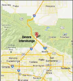 In August 2015, updates on the Devore Interchange Project (site page: http://www.devoreinterchangeproject.com/) were provided. The project broke ground in the summer of 2013, with
expected completion in 2016. The project limits on I-15 are from 2.3 miles
south to 2.0 miles north of the I-15/I-215 interchange and on I-215 from
1.0 mile south to the I-15/I-215 interchange. The total estimated cost of
the project is $324 million and is being funded through a mix of federal
(20%), state (56%) and local funds (24%). The highlights of the project
include:
In August 2015, updates on the Devore Interchange Project (site page: http://www.devoreinterchangeproject.com/) were provided. The project broke ground in the summer of 2013, with
expected completion in 2016. The project limits on I-15 are from 2.3 miles
south to 2.0 miles north of the I-15/I-215 interchange and on I-215 from
1.0 mile south to the I-15/I-215 interchange. The total estimated cost of
the project is $324 million and is being funded through a mix of federal
(20%), state (56%) and local funds (24%). The highlights of the project
include:
In May 2016, it was reported that, after 20 years of
planning and three years of construction, transportation officials
celebrated the completion of the Devore Interchange improvement project,
where I-215 and I-15 meet. The improvements — new lanes and bridges
— are anticipated to shave as much as 30 minutes to an hour off
commute time for residents driving through the pass. The project also
promises to spark major economic growth for the High Desert with easier
access for people and commerce moving though the pass. As one of three
major routes in and out of Southern California, the Devore Interchange had
become one of the worst road bottlenecks in the nation with traffic queues
backing up as far as five miles and hour-long waits for some. The $324
million Devore Interchange Project, officials said, improves mobility and
maximizes operations through the corridor by adding a new lane in each
direction, building a new connector, adding 2 miles of truck bypass lanes
in each direction, and adding 17 new bridges. The project was delivered 18
months ahead of schedule. Officials also celebrated completion of the
Cajon Pass Rehabilitation Project, which saw the reconstruction of 50
lane-miles of outer-lane pavement that had deteriorated since being laid
down in the early 1970s. The Devore project significantly improves safety
for all drivers moving throughout the area, with the addition of truck
bypass lanes, and easier connections between the freeways.
(Source: San Bernardino Sun, 5/20/2016)
Devore (Northern I-15/I-215 split) to Barstow (I-40)
Hesperia: Ranchero Road Improvements (~ SBD 30.395)
In May 2010, the CTC approved for future consideration of funding a project in San Bernardino County that will construct a new interchange at the intersection of Route 15 and Ranchero Road (~ SBD 30.395) in the city of Hesperia. The project is programmed in the 2008 State Transportation Improvement Program and includes local funds. Total estimated project cost is $98,200,000 for capital and support. Construction is estimated to begin in Fiscal Year 2010-11. The project will involve construction activities in the habitat of the Cooper’s hawk, a State listed species of special concern. In addition, the project has the potential for growth inducement and impacts to visual resources.
In March 2011, the CTC approved a new public road connection at Ranchero Road to I-15 in the city of Hesperia in San Bernardino County. This is approximately 1.8 miles north of the existing Oak Hill Road interchange. The proposed project is needed to provide access to future development along Ranchero Road and reduce congestion at the Main Street interchange, the Joshua Street interchange, and the Oak Hill Road interchange by adding a new interchange at Ranchero Road. In addition to reducing congestion, the project is expected to enhance traffic operations and provide a Level of Service that is consistent with the goals of the City’s Congestion Management Plan. In May 2012, the CTC approved $33.1 million to rebuild the Ranchero Road intersection with I-15 in Hesperia.
In December 2012, the CTC relinquished right of way in the city of Hesperia along Route 15 on Main Street (~ SBD 34.029) and Mariposa Road (~ SBD 30.874 to SBD 32.612), consisting of collateral facilities.
Mesa Road/Nisquali Road Interchange (~ SBD 38.783)
The SAFETEA-LU act, enacted in August 2005 as the reauthorization of TEA-21, provided the following expenditures on or near this route:
In January 2012, the CTC approved reducing the original CMIA allocation for construction for the Route 15/La Mesa Road/Nisquali Road Interchange project (PPNO 0172T) in San Bernardino County by $5,118,000, from $21,324,000 to $16,206,000. The contract was awarded on December 7, 2011. This project is in Victorville, on Route 15 at La Mesa Road/Nisquali Road between Bear Valley Road and Palmdale Road (Route 18); it will construct an interchange at La Mesa/Nisquali Road and realign frontage roads.
Victorville Interchange Improvements/Widening: Mojave Drive (~ SBD 41.98) to Stoddard Wells (~ SBD 48.434)
There are also plans to add northbound and southbound mixed flow lanes between Victorville and Barstow at Mojave Drive (~ SBD 41.98) (CTC December 2001 Agenda items 2.5b(1) Projects 2 and 3).
In 2007, two projects were submitted for funding from the Corridor Mobility Improvement Account; neither were recommended for funding. These projects were widening of the route between Victorville to Barstow ($46,432K requested, total costs $136,481K) and construction of 2 new interchanges in Victorville ($44,352K requested, total cost $134,096K).
In July 2010, the CTC approved for future consideration of funding a project that will construct roadway improvements including intersection improvements at three locations on Route 15 in the city of Victorville. The project is programmed in the 2010 State Transportation Improvement Program and includes federal and local funds. Construction is estimated to begin in Fiscal Year 2012-13. Total estimated project cost is $146,676,000 for capital and support.
The scope of work for this project (EA 35556) includes
the reconstruction of existing "D", "E" Street and Stoddard Wall Road
interchange, widen Victorville Separation Overhead, construct new North
bound (N/B) Collector Distributor Bridge over "D" and "E" Street,
Burlington Northern Santa Fe (BNSF) Railroad, widen Mojave River Bridge
& construct new West Frontage Road Bridge over Mojave River, upgrade
4.1 miles of the mainline to current roadway standards, realign East
Frontage Road, construct new West Frontage Road & add an auxiliary
lane & deceleration lane. The scope of work for this project proposes
various gateway enhancements in the City of Victorville with the
incorporation of a rock blanket and creative aesthetic retaining walls.
(Source: Caltrans District 8 Project Page, Jul 2018)
In December 2014, the CTC authorized $79,507,000 for Route 15 Widening Phase 2. This is a project in Victorville, between Mojave Drive and 1 mile north of the Stoddard Wells Road overcrossing that will reconstruct three interchanges, widen one bridge and upgrade 4 miles of mainline to current roadway standards.
In March 2016, it was reported that Caltrans officials
have begun a #71 million project to reconstruct the interchanges at D
Street (~ SBD 43.495), E Street (~ SBD 43.526), and Stoddard Wells (~ SBD
47.434); and to widen the Mojave River Bridge (SBD 043.86) on I-15 in
Victorville. The work has begun clearing brush, placing construction signs
and securing the area of any environmental issues, including relocating
endangered bird nesting and bats. Caltrans has worked with the city of
Victorville and Apple Valley, including emergency responders to ensure the
safety and success of the project.
(Source: Victor Valley News, 3/26/2016)
The 2020 STIP, approved at the March 2020 CTC meeting,
continued the programmed funding for PPNO 0174L "Route 15 Widening Phase 2
(Supplemental-RIP)". It also included PPNO 0174L Route 15 Widening Phase 2
(Supplemental-IIP, in the Interregional portion of the STIP with no change
in programming: $13,056K in prior year funding.
(Source: March 2020 CTC Agenda, Item 4.7, 2020 STIP
Adopted 3/25/2020)
In September 2010, the CTC approved relinquishment of right of way in the city of Victorville along Route 15 from the city limits with Apple Valley to 0.1 mile southerly, consisting of frontage road and adjacent drainage easement (~ SBD 45.066 to SBD 45.166) .
High Speed Rail - Southern California to Las Vegas (Phase 1: Victorville to Las Vegas)
In July 2020, it was reported that a plan to build a
high-speed train between Southern California and Las Vegas got a boost
after the rail company in charge of the project received permission to
build along I-15. Specifically, Caltrans announced that XpressWest entered
into a lease agreement with the California Department of Transportation to
construct the rail line on I-15’s median. Approximately 135 miles of
the 170-mile rail system will be in California. The project will be
privately financed and will cost about $7 billion, according to 2018
estimates. It expects to first complete a link between Las Vegas and
Victorville, California, with plans to eventually extend the line another
80 miles (130 kilometers) to Los Angeles. The project stalled several
times over the past decade, mostly over financing.
(Source: KTLA, 6/30/2020)
In February 2009, the CTC approved relinquishment of right of way in the town of Apple Valley along Route 15 on East Frontage Road from the town limit line to Stoddard Wells Road (~ SBD 47.434 to SBD 48.287), consisting of a frontage road and adjacent drainage facilities.
Barstow (I-40) to the Nevada State Line
In July 2017, it was reported that a little teaming and scheming is
brewing between Las Vegas Mayor Carolyn Goodman and Los Angeles Mayor Eric
Garcetti. The mayoral duo recently met to discuss an array of mutual
topics, including a desire to widen the two-lane stretch of I-15 between
Barstow and Primm, NV (on the state border)— a feat Goodman and her
predecessors have long sought as a way to reduce traffic congestion for
Southern Californians driving to Las Vegas. In order to get those federal
and state dollars to pay for such a costly project, Goodman said the
conversation needs to shift away from tourism and focus more on interstate
trade. Of the 42.9 million visitors to Las Vegas in 2016, about 27 percent
came from Southern California — the majority of whom drove along
Interstate 15, according to the Las Vegas Convention and Visitors Bureau.
The gridlock is compounded by big rigs delivering electronics, clothes and
other goods shipped through Southern California’s ports in Los
Angeles, Long Beach and San Diego on to the rest of the country. The
average travel time between San Bernardino and Las Vegas is 3.5 hours,
while the southbound trip can last up to 7 hours on Sunday afternoons due
to bottlenecks near Primm and Barstow, according to an updated master plan
released earlier this year by Caltrans. The Caltrans report also noted
that the cost of congestion on the entire stretch of I-15 equates to $6.2
billion annually, with more than half attributed to choke points between
Los Angeles and Las Vegas. Yet, widening I-15 between Barstow and Primm
isn’t on the agency’s list of planned projects into the near
future. Goodman said she is enlisting help from Rudy Malfabon, director of
the Nevada Department of Transportation. Malfabon said he had previously
discussed the topic with Caltrans and confirmed that the agency
doesn’t have any immediate plans to widen I-15.
(Source: Las Vegas Review Journal, 7/9/2017)
In August 2011, the CTC approved $9,765,000 in SHOPP funding for repairs in and near Barstow, from Route 58 to Main Street, that will resurface pavement on 21.2 lane miles to improve safety and ride quality. (~ SBD 70.169 to SBD 74.93)
In August 2015, the CTC authorized relinquishment of 08-SBd-58-PM R33.4 (Route 58) and 08-SBd-15-PM 71.5/72.0 (I-15): Relinquishes right of way in the city of Barstow along Route 15 on Main Street (formerly Route 31, formerly Route 66) and at “L” Street, consisting of superseded highway and collateral facilities. There's a little bit of Route 58 in there as well, near Main Street. The City, by freeway agreement dated November 19, 1990, agreed to accept title upon relinquishment by the State, and by Resolution No. 4868-2017, agreed to waive the 90-day requirement and accept the relinquishment.
Southbound Truck Climbing Lanes (~ SBD 77.512/R80.996, ~ SBD R115.262/R118.995)
Portions of this route are currently undergoing a Nevada Dept. of Transportation (NDOT) funded widening. There is also a CalTrans project to add a southbound truck climbing lane at two locations in San Bernardino County (CTC January 2001 Agenda, item 2.1c.(1) item 60). Additionally, in April 2002, the CTC (Agenda Item 2.5b.(1)) considered STIP Project #7, which would add a NB truck climbing lane near Cajon Pass from 0.1 km S of Route 138 to 0.1 km S of Oak Hill Road. This was still on the agenda in 2006: Project #60 is to construct the two separate truck-climbing lanes on Route 15 in San Bernardino County. This project has been segmented into two sub-projects for implementation. The original plan was to fully fund Project #60.1 (lanes just N of Barstow) solely with TCRP funds and Project #60.2 (lanes S of Baker) solely with STIP-IIP funds. However, due to the previous temporary suspension of allocating new TCRP funds, Project #60.1 is currently under construction utilizing a portion of the TCRP funds ($860,000) combined with SHOPP funds. As a result, $9,140,000 in TCRP funds are now available for Project #60.2. Project #60.2 is ready to be advertised for construction in March 2006. All project development costs have been completed using STIP-IIP funds. With Construction Support being funded with STIP-IIP funds, the Department proposes to fund Construction Capital with the now available TCRP funds.
There are plans to add a southbound truck climbing lane at two locations in San Bernardino County. This is TCRP Project #60. This project will be delayed, the August 2004 CTC agenda has a request for an amendment to deprogram $95,000 in TCR funds, update funding plan and project schedule previously approved.
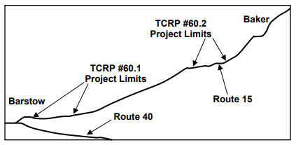 In March 2006, the TCR Program – Application
Approval Project #60.2 noted: The overall project is to construct
truck-climbing lanes in two locations on I-15 in the southbound direction.
This project has been segmented into two sub-projects for implementation:
In March 2006, the TCR Program – Application
Approval Project #60.2 noted: The overall project is to construct
truck-climbing lanes in two locations on I-15 in the southbound direction.
This project has been segmented into two sub-projects for implementation:
The March 2006 STIP Amendment noted: Project #60 is to construct the two separate truck-climbing lanes on Route 15 in San Bernardino County. This project has been segmented into two sub-projects for implementation. The original plan was to fully fund Project #60.1 solely with TCRP funds and Project #60.2 solely with STIP-IIP funds. However, due to the previous temporary suspension of allocating new TCRP funds, Project #60.1 is currently under construction utilizing a portion of the TCRP funds ($860,000) combined with SHOPP funds. As a result, $9,140,000 in TCRP funds are now available for Project #60.2. Project #60.2 is ready to be advertised for construction. All project development costs have been completed using STIP-IIP funds. With Construction Support being funded with STIP-IIP funds, the Department proposes to fund Construction Capital with the now available TCRP funds.
Yermo Agricultural Inspection Station (SBD R87.259)
In September 2018, it was reported that Caltrans
completed work on Phase II at the Joint Port of Entry (JPOE) on southbound
I-15 just south of the California/Nevada state line and now is in the
process of dismantling the old Agricultural Inspection Station on
southbound I-15 in Yermo. The $43 million project constructed a new
Agriculture Inspection Station facility just south of Primm, Nevada (~ SBD
179.561), that serves only passenger cars and trucks. Big rigs use a
separate facility that requires them to exit I-15 before the new
Agricultural Inspection Station. The project was completed by Granite
Construction Company. The new alignment of I-15 at the Nevada State Line
allows big rigs to enter Phase I of the JPOE to access the California
Highway Patrol Commercial Vehicle Enforcement Facility and now four lanes
of passenger vehicle traffic continue through the new Agricultural
Inspection Station for inspection. The previous inspection station near
Yermo, often caused traffic backups as cars and trucks would share 2 lanes
until just before arriving at the station. It also was avoidable by using
local roads. State officials were very concerned about big rigs using
local roads to avoid traffic delays. The new station doesn't eliminate all
backups on that part of I-15. The freeway does go from 3 lanes to 2 when
it reaches Primm, but opens up to 3 lanes well before the station, with up
to 6 lanes available for drivers to pass through. Once drivers have been
given permission to continue, there is a 3rd lane for trucks
and slow-moving traffic help ease congestion up the hill toward Nipton Rd.
The Yermo facility was built in 1963.
(Source: Daily Press, 9/7/2018; NBC4
LA 10/13/2018)
In December 2018, it was reported that the new agricultural inspection statement in Primm had been opened, and the Yermo station was closed. This includes a diversion from the old I-15 alignment.
In January 2018, it was reported that paper signs placed over the
existing sign that listed emergency contact information and phone numbers
on the "Welcome to California" signs at the border had been removed. The
signs, first noticed by a handful of Twitter users, read "Official
Sanctuary State," and "Felons, Illegals, and MS13 Welcome! Democrats Need
The Votes!" California became a sanctuary state on January 1, 2018,
following a bill signed by Governor Jerry Brown in October. The bill
prevents state law enforcement officers from inquiring about a person's
immigration status, from arresting persons because of civil immigration
warrants, or from participating in a joint task force with federal
officials to enforce immigration laws. The intent is to not discourage
undocumented immigrants from working with law enforcement due to fear that
their cooperation would get them deported. One sign was found and promptly
removed Monday on Interstate 15 near Mountain Pass (~ SBD 170.503), just
west of the California-Nevada border. Another was removed from I-40 in the
Needles area near the California-Nevada border. Caltrans has also received
unconfirmed reports of up to three more fake signs — two of which
are reported to be near the Oregon border — but they have not yet
been able to verify the existence of those. The Twitter photo included a
white paddle indicating at least one sign was on Route 95 near Palm
Gardens (the paddle shows "CL", likely referring to Clark County, and the
point where US 95 transitions from California to Nevada).
(Source: SFGate, 1/2/2018; Snopes, 1/2/2018)
Nipton Wildlife Crossings (08-SBd-15 R114.0/171.5)
In June 2023, the CTC approved the following capital
project amendment to the 2022 SHOPP: 08-SBd-15 R114.0/171.5. PPNO
08-3021K; ProjID 0823000021; EA 1N590. I-15 Near Baker, from 2.4 miles
north of Afton Road to 5.0 miles south of Nipton Road. Construct
three wildlife crossings. Additional contribution of $1,500,000 for
PA&ED, $2,250,000 for PS&E, $60,000 for R/W support, $5,260,000
for Construction Support, and $23,861,000 for Construction Capital from
Brightline West and California Department of Fish and Wildlife. Concurrent
COS allocation under Resolution FP-22-96; June 2023. Allocation ($ ×
1,000): PA&ED $4,500; PS&E $6,750; R/W Sup $180; Con Sup $15,780;
R/W Cap $652; Const Cap $71,583; TOTAL $99,445. FY23-24. Begin Const:
4/23/2024.
(Source: June 2023 CTC Agenda, Agenda Item 2.1a.(2a) #2)
In June 2023, the CTC approved the following SHOPP
Pre-Construction Phase (environmental support, design, and R/W support)
allocation: $4,500,000. 08-SBd-15 R114.0/171.5. PPNO 08-3021K; ProjID
0823000021; EA 1N590. I-15 Near Baker, from 2.4 miles north of Afton Road
to 5.0 miles south of Nipton Road. Construct three wildlife crossings.
Concurrent Amendment under SHOPP Amendment 22H-010; June 2023. Allocation:
PA&ED $6,000,000 $4,500,000.
(Source: June 2023 CTC Agenda, Agenda Item 2.5b.(2a) #15)
In the Mountain Pass area (~ SBD 170.503), rather than let traffic back up in the two southbound lanes that remained open, the NB lanes have been restriped to eliminate the shoulder, and Jersey Barriers have been installed in order to squeeze in a SB lane in addition to the two NB lanes on the NB side of the freeway. Two of the three SB lanes remain open on the SB side. SB cars leaving Nevada have the choice to use the Autos Only Express Lane, or share the two regular lanes with (slow) trucks.
In May 2015, the CTC approved for future consideration of funding a project that will will repair or replace the existing bridges at Cenda Ditch (SBD 172.11L) and Wheaton Wash (SBD 173.84L) on I-15 near the Nevada state line. The project is programmed in the 2014 State Highway Operation and Protection Program. The estimated cost is $16,864,000 for capital and support. Construction is estimated to begin in Fiscal Year 2015-16. The scope, as described for the preferred alternative, is consistent with the project scope programmed by the Commission in the 2014 State Highway Operation and Protection Program.
Temporary Lines / Route 15 Widening near Primm NV
In December 2021, it was reported that a new plan to
ease the traffic congestion that builds up to the L.A. area following
weekend getaways to Las Vegas was announced. The shoulder portion of a
five-mile stretch of southbound I-15 between the Nevada state line and the
California Food and Agriculture checkpoint will be converted for use as an
extra lane during peak hours, California Gov. Gavin Newsom and Nevada Gov.
Steve Sisolak said during a joint news conference to announce the plan.
Traffic is currently reduced from three lanes to two lanes through the
area, before later opening back up to three lanes. The project will use
the freeway’s shoulder area to keep the freeway open to three lanes
of traffic during peak hours on Sundays and Mondays. The project is
estimated to cost $12 million and is expected to be completed by the end
of summer 2022.
(Source: KTLA, 12/6/2021)
In February 2023, it was reported that the widening of
I-15 from Barstow to the Nevada state line, a project that was anticipated
to complete nearly one year ago (2022), was still lingering. As of
February 2023, the most noticeable progress made is the conversion of the
interstate’s shoulder into a third lane for one mile near the state
line.
(Source: KLAS, 2/24/2023)
In March 2023, the CTC was given notice of, and in May
2023, the CTC approved, an amendment to the 2022 STIP that programs
$1,629,000 in Interregional Improvement Program (IIP) funds to a new STIP
project – Interstate 15 (I-15) Dynamic Cantilever Extinguishable
Message Signs (EMS) project (PPNO 08-3020Y; EA 1N121) on southbound I-15
between the California Department of Food and Agriculture Mountain Pass
Station and the California/Nevada State Line in San Bernardino County, for
the construction capital and construction support phases in Fiscal Year
2023-24. This project is a pilot project in San Bernardino County on
southbound (SB) I-15 between the California Department of Food and
Agriculture Mountain Pass Station and the California/Nevada State Line.
The SB I-15 lanes at the California/Nevada State Line experiences
recurring traffic congestion on Sundays, Mondays and during other major
events, causing severe traffic delays for extended periods. The purpose of
this pilot project is to install an electronic lane control system that
informs motorists when the part-time shoulder is available to be used on
SB I-15 between postmile 180.90 and 185.50. This project will
upgrade the signing to allow for part-time shoulder use as needed and will
increase visibility. The scope of this project is comprised of
installing cantilever EMS, flashing beacons, cameras, and additional
roadside signs within project limits to improve operational conditions.
When the I-15 Dynamic Cantilever EMS project (PPNO 3020Y) is completed,
the outside shoulder will be used as a part-time third lane on this
segment of SB I-15. The part-time shoulder use will be limited to
Sunday and Monday peak hours. The EMS and cameras proposed in the
project are Transportation Management System equipment. There is no
roadway improvement nor striping involvement in this project. Once
this pilot project is complete, peak congestion travel times will be
monitored for three years and compared to the already completed traffic
simulation analysis that evaluated the travel time savings resulting from
this operational improvement. If the travel time savings are
consistently achieved, these improvements will become permanent. If
the project benefits are not achieved, the EMS, flashing beacons, cameras,
and additional roadside signs will be removed using other funds.
(Source: March 2023 CTC Agenda, Agenda Item 2.1b.(4); May 2023 CTC
Agenda, Agenda Item 2.1a.(5))
In May 2023, the CTC approved the following allocation
for a locally-administered STIP project: $1,629,000. 08-SBd-015
180.9/185.5. PPNO 08-3020Y; ProjID 0823000023; EA 1N121. I-15 Dynamic
Cantilever Extinguishable Message Signs. In San Bernardino County,
on I-15, from California Department of Food and Agriculture Mountain Pass
Station, to the California / Nevada State Line. Install dynamic
cantilever Extinguishable Message Signs (EMS) to improve operational
conditions along southbound I-15, between Post Miles (PM) 180.9 and 185.5.
CEQA - CE, 11/08/2022; Re-validation 01/27/2023 NEPA - CE, 11/08/2022;
Re-validation 01/27/2023. Right of Way Certification: 01/19/2023
Concurrent STIP Amendment for Action under Resolution 22S-13; May 2023.
Allocation: CON ENG $380,000; CONST
$1,249,000.
(Source: May 2023 CTC Agenda, Agenda Item 2.5c.(4))
In August 2023, it was reported that, according to
Caltrans officials, the I-15 part-time southbound travel lane is set to
open for use starting Sunday, August 27, 2023. The expanded access will
allow travelers to use the right shoulder past the NV/CA border every
Sunday and Monday from 10 a.m. to 8 p.m.
(Source: News 3 Nevada, 8/27/2023)
 Commuter Lanes
There is a 2-lane reversable HOV lane, about 7.5 miles, between the Route 163 interchange and North City Parkway. These lanes opened in October 1988, require two or more occupants, and operate 6:00am-9:00am (SB), 3:00pm-6:30pm (NB). (~ SD M11.831 to SD 27.61)
Assembly Bill 713, Chapter 962 in 1993 authorized congestion pricing for the lanes in San Diego County, allowing the lanes to be used as toll lanes for single-passenger vehicles. The program was continued by Senate Bill 252, Chapter 481, on 9/27/1999. This program allows fee-based travel of the HOV lane by single-occupant vehicles during peak periods as long as a predefined level of service is maintained. The program was continued indefinately by Senate Bill 313, Chapter 275, 9/10/2001 and Assembly Bill 574, Chapter 498, 10/11/2007. Individual drivers use a FasTrak transponder, and must open an account with the San Diego Association of Governments, which administers the program. The California Highway Patrol enforces the tolls, inspecting cars to see if transponders are visibly displayed. Drivers can be cited if the removable equipment isn't in the right place. Tolls are 50 cents when the lanes are nearly empty. During peak commute periods, they are likely to be between $2.50 and $4, topping out between 7 and 8 AM for the southbound commute and 4:30 to 5:30 PM northbound. Occasionally, tolls have reached as high as $8. According to SANDAG in October 2003, the managed lanes carry about 22,000 vehicles daily, more than three times the volume seen when they first opened. Roughly three-quarters are high-occupancy vehicles. The rest are FasTrak users.
There is currently work to extend the lanes north from Rancho Peñasquitos (~ SD 18.178). This segment will have the first direct-access ramps in the corridor, serving a Bus Rapid Transit project that is being developed to attract commuters who don't normally use public transportation. An additional extension north comes later, and the existing segment will be reconfigured, ultimately creating a 20-mile, four-lane corridor with multiple on-and off-ramps.
HOV lanes are planned as follows:
 Historical Route
This portion of this route that was part of US 395 is part of "Historic US Highway 395", designated by Assembly Concurrent Resolution 98, Chapter 79, 7/8/2008.
This portion of this route from the northern I-15/I-215 junction to I-40 is part of "Historic Highway Route 66", designated by Assembly Concurrent Resolution 6, Chapter 52, in 1991.
NamingThe segment of this route between I-805 and Route 91 is officially named the "Escondido Freeway". The segment between I-805 (~ SD M4.039) and Route 91 (~ RIV 41.286) was named by the State Highway Commission in 1957. The segment between I-8 (~ SD R6.342) and Route 215 (~ RIV 8.334) also received this name officially from Assembly Concurrent Resolution No. 34, Chapter 67, in 1979. The name arises from the fact the route goes through the City of Escondido.
 In San Diego County, I-15 is called the "Cabrillo" Freeway
(between Route 163 (~ SD M11.41) and the SD/RIV county line (SD 54.258/RIV
0.0)); the Cabrillo Freeway name continues SB along Route 163.
Juan Rodríquez Cabrillo was the leader of one of the first European
expeditions to California. In 1542, Cabrillo led the first European
expedition to explore what is now the west coast of the United States.
Cabrillo was commissioned by Pedro de Alvarado, Governor of Guatemala, for
a voyage up the California coast under the flag of Spain. Cabrillo hoped
to find the fabulously wealthy cities known as Cibola, believed to be
somewhere on the Pacific coast beyond New Spain, and a route connecting
the North Pacific to the North Atlantic. Cabrillo reached "a very good
enclosed port" which is now San Diego bay, on September 28, 1542, naming
it "San Miguel". He probably anchored his flagship, the San Salvador at
Ballast Point on Point Loma's east shore. Six days later, he departed San
Diego sailing northward and exploring the uncharted coast line of
California. The expedition reached San Pedro on October 6, Santa Monica on
the 9th, San Buenaventura on the 10th, Santa Barbara
on the 13th and Pt. Concepcion on the 17th. Because
of adverse winds Cabrillo turned back, harboring at San Miguel Island, and
did not progress beyond Santa Maria until November 11. With a favorable
wind later that day they reach the "Sierra de San Martin," probably Cape
San Martin and the Santa Lucia Mountains in southern Monterey County.
Struck by a storm and blown out to sea, the two vessels are separated and
do not rejoin until the 15th, probably near Año Nuevo
north of Santa Cruz. The next day they drifted southward, discovering
"Bahía de los Pinos" and "Cabo de Pinos." These are most likely
Monterey Bay and Point Pinos. On the 18th they turned south,
passing snow-capped mountains (the Santa Lucias), and on November 23
returned to their harbor at San Miguel Island, where they remained for
nearly three months. Cabrillo died January 3, 1543, on San Miguel Island,
and may have been buried on Catalina Island. He died from complications of
a broken leg incurred from a fall during a brief skirmish with natives. It
was named by Assembly Bill 1769, Chapter 569, in 1959.
In San Diego County, I-15 is called the "Cabrillo" Freeway
(between Route 163 (~ SD M11.41) and the SD/RIV county line (SD 54.258/RIV
0.0)); the Cabrillo Freeway name continues SB along Route 163.
Juan Rodríquez Cabrillo was the leader of one of the first European
expeditions to California. In 1542, Cabrillo led the first European
expedition to explore what is now the west coast of the United States.
Cabrillo was commissioned by Pedro de Alvarado, Governor of Guatemala, for
a voyage up the California coast under the flag of Spain. Cabrillo hoped
to find the fabulously wealthy cities known as Cibola, believed to be
somewhere on the Pacific coast beyond New Spain, and a route connecting
the North Pacific to the North Atlantic. Cabrillo reached "a very good
enclosed port" which is now San Diego bay, on September 28, 1542, naming
it "San Miguel". He probably anchored his flagship, the San Salvador at
Ballast Point on Point Loma's east shore. Six days later, he departed San
Diego sailing northward and exploring the uncharted coast line of
California. The expedition reached San Pedro on October 6, Santa Monica on
the 9th, San Buenaventura on the 10th, Santa Barbara
on the 13th and Pt. Concepcion on the 17th. Because
of adverse winds Cabrillo turned back, harboring at San Miguel Island, and
did not progress beyond Santa Maria until November 11. With a favorable
wind later that day they reach the "Sierra de San Martin," probably Cape
San Martin and the Santa Lucia Mountains in southern Monterey County.
Struck by a storm and blown out to sea, the two vessels are separated and
do not rejoin until the 15th, probably near Año Nuevo
north of Santa Cruz. The next day they drifted southward, discovering
"Bahía de los Pinos" and "Cabo de Pinos." These are most likely
Monterey Bay and Point Pinos. On the 18th they turned south,
passing snow-capped mountains (the Santa Lucias), and on November 23
returned to their harbor at San Miguel Island, where they remained for
nearly three months. Cabrillo died January 3, 1543, on San Miguel Island,
and may have been buried on Catalina Island. He died from complications of
a broken leg incurred from a fall during a brief skirmish with natives. It
was named by Assembly Bill 1769, Chapter 569, in 1959.
(Image source: Wikipedia)
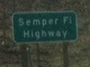 Route 15 between Route 163 and Miramar Road in
the County of San Diego (~ SD M11.695 to SD M14.286) is named the "Semper
Fi Highway". It was named in recognition of the service provided by
the Marine Corps Air Station Miramar to Americans. The Marine Corps Air
Station Miramar in southern California, which has military roots dating
back to 1917, is home to three commands that include the 3rd
Marine Aircraft Wing, the Marine Corps Air Bases Western Area, and the
Marine Aircraft Group 46, each serving their own specific function with
their own subordinate units. The Marine Corps Air Station Miramar and the
3rd Marine Aircraft Wing are dedicated to supporting West Coast
Marine aviation missions, Marine Aircraft Group 46, and other Naval
aviation support units as designated by the Commandant of the Marine Corps
in coordination with the Chief of Naval Operations. The Marine Corps Air
Station Miramar employs approximately 12,500 Marines, Sailors, and
Civilians. Named by Assembly Concurrent Resolution 121, Chapter 40, May 3,
2004.
Route 15 between Route 163 and Miramar Road in
the County of San Diego (~ SD M11.695 to SD M14.286) is named the "Semper
Fi Highway". It was named in recognition of the service provided by
the Marine Corps Air Station Miramar to Americans. The Marine Corps Air
Station Miramar in southern California, which has military roots dating
back to 1917, is home to three commands that include the 3rd
Marine Aircraft Wing, the Marine Corps Air Bases Western Area, and the
Marine Aircraft Group 46, each serving their own specific function with
their own subordinate units. The Marine Corps Air Station Miramar and the
3rd Marine Aircraft Wing are dedicated to supporting West Coast
Marine aviation missions, Marine Aircraft Group 46, and other Naval
aviation support units as designated by the Commandant of the Marine Corps
in coordination with the Chief of Naval Operations. The Marine Corps Air
Station Miramar employs approximately 12,500 Marines, Sailors, and
Civilians. Named by Assembly Concurrent Resolution 121, Chapter 40, May 3,
2004.
(Image source: Foursquare)
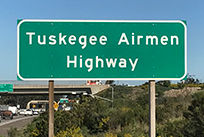 The portion of I-15 between Miramar Road
(milepost marker 14.285) and Mercy Road (milepost marker 17.311), in the
County of San Diego, is named the "Tuskegee Airmen Highway".
Named in honor of the Tuskegee Airmen. The United States Army Air Corps
formed the 332nd Fighter Group and the 477th Medium
Bombardment Group at Tuskegee Institute to train African American fighter
pilots who, until that time, had not been accepted into pilot training
programs in the military. The Tuskegee Airmen were sent to the European
Theatre in 1943 and served in combat in North Africa, Sicily, and Europe.
At the end of World War II, the Tuskegee Airmen were credited with
destroying 261 enemy aircraft, damaging 148 enemy aircraft, destroying or
damaging 940 units of enemy ground transportation, flying 15,553 combat
sorties in 1,578 missions over North Africa, Sicily, and Europe, and
conducting more than 200 bomber escort missions. The Tuskegee Airmen unit,
including its officers and enlisted personnel, received three Presidential
Unit Citations, 150 Distinguished Flying Cross and Legion of Merit awards,
the Red Star of Yugoslavia, nine Purple Hearts, 14 Bronze Stars, and more
than 700 Air Medals and Oak Leaf Cluster awards. Sixty-six of the Tuskegee
Airmen were killed in combat, and another 33 were shot down and held as
prisoners of war. The unqualified success of the Tuskegee Airmen helped
lead to the eventual integration of the United States Armed Forces. The
record of the Tuskegee Airmen in World War II was accomplished by
individuals who bravely accepted the challenge and proudly displayed their
skill and patriotism in spite of great adversity at home and abroad. The
Tuskegee Airmen, Inc. is an education and community service organization
dedicated to maintaining the traditions of the Tuskegee Airmen and
preserving the legacy of the first generation of African American military
aviators of World War II with 42 chapters throughout the United States,
and has consistently provided inspiration, motivation, mentoring, and role
models for elementary, middle, and high school students in this country.
Named by Senate Concurrent Resolution 90, Resolution Chapter 104, on
August 31, 2012. This stretch was dedicated and signed in February 2013. In attendance at the dedication were several Tuskegee airmen who now live in San Diego.
The portion of I-15 between Miramar Road
(milepost marker 14.285) and Mercy Road (milepost marker 17.311), in the
County of San Diego, is named the "Tuskegee Airmen Highway".
Named in honor of the Tuskegee Airmen. The United States Army Air Corps
formed the 332nd Fighter Group and the 477th Medium
Bombardment Group at Tuskegee Institute to train African American fighter
pilots who, until that time, had not been accepted into pilot training
programs in the military. The Tuskegee Airmen were sent to the European
Theatre in 1943 and served in combat in North Africa, Sicily, and Europe.
At the end of World War II, the Tuskegee Airmen were credited with
destroying 261 enemy aircraft, damaging 148 enemy aircraft, destroying or
damaging 940 units of enemy ground transportation, flying 15,553 combat
sorties in 1,578 missions over North Africa, Sicily, and Europe, and
conducting more than 200 bomber escort missions. The Tuskegee Airmen unit,
including its officers and enlisted personnel, received three Presidential
Unit Citations, 150 Distinguished Flying Cross and Legion of Merit awards,
the Red Star of Yugoslavia, nine Purple Hearts, 14 Bronze Stars, and more
than 700 Air Medals and Oak Leaf Cluster awards. Sixty-six of the Tuskegee
Airmen were killed in combat, and another 33 were shot down and held as
prisoners of war. The unqualified success of the Tuskegee Airmen helped
lead to the eventual integration of the United States Armed Forces. The
record of the Tuskegee Airmen in World War II was accomplished by
individuals who bravely accepted the challenge and proudly displayed their
skill and patriotism in spite of great adversity at home and abroad. The
Tuskegee Airmen, Inc. is an education and community service organization
dedicated to maintaining the traditions of the Tuskegee Airmen and
preserving the legacy of the first generation of African American military
aviators of World War II with 42 chapters throughout the United States,
and has consistently provided inspiration, motivation, mentoring, and role
models for elementary, middle, and high school students in this country.
Named by Senate Concurrent Resolution 90, Resolution Chapter 104, on
August 31, 2012. This stretch was dedicated and signed in February 2013. In attendance at the dedication were several Tuskegee airmen who now live in San Diego.
(Image source: Sen. Joel Anderson)
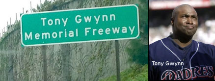 The portion of I-15 from Scripps Poway Parkway/Mercy Road
to Camino Del Norte in the County of San Diego (~ SD M17.349 to SD 21.924)
is named the "Tony Gwynn Memorial Freeway". It was named in
memory of Tony Gwynn, perhaps the greatest San Diego Padre of them all and
one of the greatest hitters in the history of Major League Baseball. Gwynn
was the first ever unanimous selection to the Padres Hall of Fame upon his
retirement in 2001 and was inducted into the National Baseball Hall of
Fame in July 2007. Gwynn was named the head baseball coach at San Diego
State in September 2001, succeeding the head coach for whom he played for
three years during his collegiate baseball career. In 20 seasons
(1982-2001), the man who will be forever known as “Mr. Padre”
won a National League record-tying eight batting titles and was selected
to 16 All-Star teams. The San Diego Padres retired his number 19 jersey in
September 2004. A native of Long Beach, Gwynn attended Long Beach Poly
High School before arriving at San Diego State in 1977 as a highly
recruited basketball point guard. After not playing baseball during his
freshman year in order to concentrate on basketball, Gwynn was given the
chance to play baseball in 1979. Gwynn became a two-time All-American
outfielder and led the Aztecs in hitting in each of his final two seasons.
Gwynn was also a point guard for the Aztec men’s basketball team for
four seasons and was named to the All-Western Athletic Conference team
twice. On June 10, 1981, Gwynn was drafted by both the San Diego Padres in
the third round of the Major League Baseball draft, and by the San Diego
Clippers in the 10th round of the National Basketball
Association draft. After signing with the San Diego Padres, Gwynn made his
major league debut on July 19, 1982. He retired with a .338 career batting
average and 3,141 hits in 2,400 games. The San Diego Padres career leader
in virtually every offensive category, Gwynn retired at 17th on
the all-time hit list, 17th on the all-time doubles list, and
eighth on the all-time singles list, and his .338 career batting average
is 22nd of all-time. Gwynn played on the first three San Diego
Padres Division Championship clubs (1984, 1996, and 1998) and batted .371
in the club’s two World Series appearances. Gwynn’s list of
honors off the field is just as impressive, as he received the Roberto
Clemente Man of the Year Award in 1999 and was awarded the 1999 Lou Gehrig
Memorial Award. In 1995, Gwynn was presented the Branch Rickey Award as
the top community activist in Major League Baseball, as well as the
inaugural San Diego Padres Chairman’s Award. Gwynn also was inducted
into the World Sports Humanitarian Hall of Fame in 1999. Gwynn was also
extremely committed to community service in the San Diego area. With his
wife, Dr. Alicia Gwynn, Gwynn established the Tony and Alicia Gwynn
Foundation, which provides programs and services to underserved children
in the areas of STEAM (science, technology, engineering, arts, and math).
Only the 17th player in history to spend his entire career of
20 or more seasons with one club, Gwynn’s unwavering loyalty to the
San Diego Padres and his undying devotion to the San Diego community
further cemented his standing as “Mr. Padre” and one of the
greatest ambassadors the game of baseball has ever known. Named by
Assembly Concurrent Resolution 63, Res. Chapter 168, Statutes of 2015 on
September 10, 2015.
The portion of I-15 from Scripps Poway Parkway/Mercy Road
to Camino Del Norte in the County of San Diego (~ SD M17.349 to SD 21.924)
is named the "Tony Gwynn Memorial Freeway". It was named in
memory of Tony Gwynn, perhaps the greatest San Diego Padre of them all and
one of the greatest hitters in the history of Major League Baseball. Gwynn
was the first ever unanimous selection to the Padres Hall of Fame upon his
retirement in 2001 and was inducted into the National Baseball Hall of
Fame in July 2007. Gwynn was named the head baseball coach at San Diego
State in September 2001, succeeding the head coach for whom he played for
three years during his collegiate baseball career. In 20 seasons
(1982-2001), the man who will be forever known as “Mr. Padre”
won a National League record-tying eight batting titles and was selected
to 16 All-Star teams. The San Diego Padres retired his number 19 jersey in
September 2004. A native of Long Beach, Gwynn attended Long Beach Poly
High School before arriving at San Diego State in 1977 as a highly
recruited basketball point guard. After not playing baseball during his
freshman year in order to concentrate on basketball, Gwynn was given the
chance to play baseball in 1979. Gwynn became a two-time All-American
outfielder and led the Aztecs in hitting in each of his final two seasons.
Gwynn was also a point guard for the Aztec men’s basketball team for
four seasons and was named to the All-Western Athletic Conference team
twice. On June 10, 1981, Gwynn was drafted by both the San Diego Padres in
the third round of the Major League Baseball draft, and by the San Diego
Clippers in the 10th round of the National Basketball
Association draft. After signing with the San Diego Padres, Gwynn made his
major league debut on July 19, 1982. He retired with a .338 career batting
average and 3,141 hits in 2,400 games. The San Diego Padres career leader
in virtually every offensive category, Gwynn retired at 17th on
the all-time hit list, 17th on the all-time doubles list, and
eighth on the all-time singles list, and his .338 career batting average
is 22nd of all-time. Gwynn played on the first three San Diego
Padres Division Championship clubs (1984, 1996, and 1998) and batted .371
in the club’s two World Series appearances. Gwynn’s list of
honors off the field is just as impressive, as he received the Roberto
Clemente Man of the Year Award in 1999 and was awarded the 1999 Lou Gehrig
Memorial Award. In 1995, Gwynn was presented the Branch Rickey Award as
the top community activist in Major League Baseball, as well as the
inaugural San Diego Padres Chairman’s Award. Gwynn also was inducted
into the World Sports Humanitarian Hall of Fame in 1999. Gwynn was also
extremely committed to community service in the San Diego area. With his
wife, Dr. Alicia Gwynn, Gwynn established the Tony and Alicia Gwynn
Foundation, which provides programs and services to underserved children
in the areas of STEAM (science, technology, engineering, arts, and math).
Only the 17th player in history to spend his entire career of
20 or more seasons with one club, Gwynn’s unwavering loyalty to the
San Diego Padres and his undying devotion to the San Diego community
further cemented his standing as “Mr. Padre” and one of the
greatest ambassadors the game of baseball has ever known. Named by
Assembly Concurrent Resolution 63, Res. Chapter 168, Statutes of 2015 on
September 10, 2015.
(Image source: KPBS, NY Times)
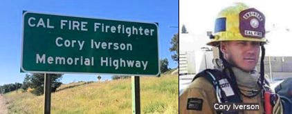 The portion of I-15 between
Via Rancho Parkway Overcrossing (SD M26.970) and Route 78 (SD R31.5) in
the County of San Diego is named the “CAL FIRE Firefighter Cory
Iverson Memorial Highway”. It was named in memory of
Department of Forestry and Fire Protection (CAL FIRE) Fire Apparatus
Engineer Cory Iverson passed away in the line of duty on December 14,
2017, at 32 years of age, while battling the Thomas Fire in the County of
Ventura. Cory Iverson was born in Escondido in January 1985, where he was
also raised. After graduating from high school, Cory worked various jobs
before discovering his passion for firefighting and making it his career.
Cory Iverson was an eight-year veteran of CAL FIRE following the footsteps
of his uncle, Stephen Thomas, a retired CAL FIRE Fire Captain. Cory looked
up to his uncle and respected him greatly, knowing firefighting was also
the career for him. Cory Iverson received many career awards, one being
the 2010 CAL FIRE Firefighter of the Year. On December 14, 2017, Cory
Iverson was engaged in the placement of a hose lay supporting a dozer
line. While attempting to suppress spot fires below the dozer line, Cory
became trapped by fire and suffered fatal injuries. We honor Cory Iverson
for his dedication to public service and for his ultimate sacrifice in the
line of duty. Cory Iverson exemplified the professionalism, work ethic,
dedication, and self-sacrifice for which CAL FIRE firefighters are known.
Cory touched the lives of many and is sorely missed by all who knew him.
Cory will never be forgotten. Named by Assembly Concurrent Resolution
(ACR) 205, Res. Chapter 152, 8/17/2018.
The portion of I-15 between
Via Rancho Parkway Overcrossing (SD M26.970) and Route 78 (SD R31.5) in
the County of San Diego is named the “CAL FIRE Firefighter Cory
Iverson Memorial Highway”. It was named in memory of
Department of Forestry and Fire Protection (CAL FIRE) Fire Apparatus
Engineer Cory Iverson passed away in the line of duty on December 14,
2017, at 32 years of age, while battling the Thomas Fire in the County of
Ventura. Cory Iverson was born in Escondido in January 1985, where he was
also raised. After graduating from high school, Cory worked various jobs
before discovering his passion for firefighting and making it his career.
Cory Iverson was an eight-year veteran of CAL FIRE following the footsteps
of his uncle, Stephen Thomas, a retired CAL FIRE Fire Captain. Cory looked
up to his uncle and respected him greatly, knowing firefighting was also
the career for him. Cory Iverson received many career awards, one being
the 2010 CAL FIRE Firefighter of the Year. On December 14, 2017, Cory
Iverson was engaged in the placement of a hose lay supporting a dozer
line. While attempting to suppress spot fires below the dozer line, Cory
became trapped by fire and suffered fatal injuries. We honor Cory Iverson
for his dedication to public service and for his ultimate sacrifice in the
line of duty. Cory Iverson exemplified the professionalism, work ethic,
dedication, and self-sacrifice for which CAL FIRE firefighters are known.
Cory touched the lives of many and is sorely missed by all who knew him.
Cory will never be forgotten. Named by Assembly Concurrent Resolution
(ACR) 205, Res. Chapter 152, 8/17/2018.
(Image source: CalFIRE (SD County) Tweet via Patch; VCStar,
1/14/2018)
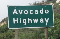 The section of I-15 between Route 78 and the City of Temecula (~
SD R31.72 to RIV R1.879) is designated the "Avocado Highway".
This is in recognition of the fact that nearly 50 percent of the avocados
consumed in the US are grown in San Diego County. California Avocados are
grown by nearly 4,000 farmers on approximately 52,000 acres. A single
California Avocado tree can produce about 500 avocados (or 200 pounds of
fruit) a year. However, the average tree usually produces approximately
150 avocados. Avocados mostly grow on the coastal strip between San Luis
Obispo and the Mexican border. These areas are ideal due to the rich soils
and mild climates. Approximately 35 percent of California Avocados are
grown in San Diego County and 33 percent in Ventura The avocado is a
Native American plant with a long, distinguished history. Today, the most
popular variety is the Hass. The mother tree of all Hass avocados was born
in a backyard in La Habra Heights, California. Named by Senate Concurrent
Resolution 9, Chapter 62, in 1997.
The section of I-15 between Route 78 and the City of Temecula (~
SD R31.72 to RIV R1.879) is designated the "Avocado Highway".
This is in recognition of the fact that nearly 50 percent of the avocados
consumed in the US are grown in San Diego County. California Avocados are
grown by nearly 4,000 farmers on approximately 52,000 acres. A single
California Avocado tree can produce about 500 avocados (or 200 pounds of
fruit) a year. However, the average tree usually produces approximately
150 avocados. Avocados mostly grow on the coastal strip between San Luis
Obispo and the Mexican border. These areas are ideal due to the rich soils
and mild climates. Approximately 35 percent of California Avocados are
grown in San Diego County and 33 percent in Ventura The avocado is a
Native American plant with a long, distinguished history. Today, the most
popular variety is the Hass. The mother tree of all Hass avocados was born
in a backyard in La Habra Heights, California. Named by Senate Concurrent
Resolution 9, Chapter 62, in 1997.
(Image source: Pinterest; Additional information from the California Avocado Commission)
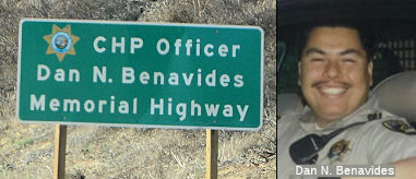 The portion of Route 15
between Gopher Canyon Road (SD 40.84) and the Old Highway 395 overcrossing
(SD 43.28) in the County of San Diego is named the "CHP Officer Dan N.
Benavides Memorial Highway". It was named in memory of CHP Officer
Daniel Nava Benavides, who was born on November 27, 1970, in Monterrey,
Mexico. His mother, Consuelo, a resident of San Jose, California, went to
Mexico to be with family for the birth and shortly there after returned to
San Jose. Officer Benavides graduated from Andrew Hill High School in San
Jose in 1989 and attended Cuesta College in San Luis Obispo. In 1997,
Officer Benavides, badge number 15193, graduated from the California
Highway Patrol Academy as a pilot officer and was assigned to the Monterey
area. After 33 months of service in the Monterey area, Officer Benavides
served in San Jose from 1999 to 2000, in San Diego from 2000 to 2003, in
Oceanside from 2003 to 2005, and in the Border Division Thermal Air
Operations Unit from 2005 to 2010. On May 7, 2010, Officer Benavides began
his shift at 7:30 a.m. working speed enforcement for the air operations
unit. Approximately two hours later, Officer Benavides was in route to
Route 8 to work speed enforcement in the El Centro area, when his Cessna
206 airplane crashed in a remote area of the Anza-Borrego Desert in
Borrego Springs, California. Officer Benavides was a hard-working,
dedicated officer who loved his job and enjoyed the people he worked with.
He was known for being a loyal family man and a wonderful father and
husband. His greatest joys were his wife and daughter and spending time
with friends and family. He had an incredible sense of humor and a keen
sense of knowledge of music and computers. In his spare time, Officer
Benavides enjoyed camping, scuba diving, barbequing, and anything to do
with sports. Named by Senate Concurrent Resolution 30, Resolution Chapter
92, on September 15, 2011.
The portion of Route 15
between Gopher Canyon Road (SD 40.84) and the Old Highway 395 overcrossing
(SD 43.28) in the County of San Diego is named the "CHP Officer Dan N.
Benavides Memorial Highway". It was named in memory of CHP Officer
Daniel Nava Benavides, who was born on November 27, 1970, in Monterrey,
Mexico. His mother, Consuelo, a resident of San Jose, California, went to
Mexico to be with family for the birth and shortly there after returned to
San Jose. Officer Benavides graduated from Andrew Hill High School in San
Jose in 1989 and attended Cuesta College in San Luis Obispo. In 1997,
Officer Benavides, badge number 15193, graduated from the California
Highway Patrol Academy as a pilot officer and was assigned to the Monterey
area. After 33 months of service in the Monterey area, Officer Benavides
served in San Jose from 1999 to 2000, in San Diego from 2000 to 2003, in
Oceanside from 2003 to 2005, and in the Border Division Thermal Air
Operations Unit from 2005 to 2010. On May 7, 2010, Officer Benavides began
his shift at 7:30 a.m. working speed enforcement for the air operations
unit. Approximately two hours later, Officer Benavides was in route to
Route 8 to work speed enforcement in the El Centro area, when his Cessna
206 airplane crashed in a remote area of the Anza-Borrego Desert in
Borrego Springs, California. Officer Benavides was a hard-working,
dedicated officer who loved his job and enjoyed the people he worked with.
He was known for being a loyal family man and a wonderful father and
husband. His greatest joys were his wife and daughter and spending time
with friends and family. He had an incredible sense of humor and a keen
sense of knowledge of music and computers. In his spare time, Officer
Benavides enjoyed camping, scuba diving, barbequing, and anything to do
with sports. Named by Senate Concurrent Resolution 30, Resolution Chapter
92, on September 15, 2011.
(Image sources: Flikr, CHP Memorial Page)
The segment of Route 15 from the San Diego County Line (RIV 0.0) to Bundy Canyon Road (~ RIV 16.292) near Lake Elsinore is named the "Temecula Valley Freeway". It was named by Assembly Concurrent Resolution 125, Chapter 78, in 1990. This naming supersedes portions of the Escondido and Coronado Freeways.
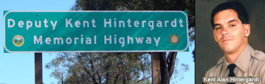 The 4.3 mile portion of I-15 from the
South Route 79 Exit at Route 79 to the I-215 interchange in Temecula (~
RIV 3.542 to RIV 8.84) is named the "Deputy Kent Hintergardt Memorial
Highway" It was named in memory of Deputy Kent Alan Hintergardt,
born in Whittier on December 14, 1959. Deputy Hintergardt graduated from
California High School in Whittier, and earned an Associates Degree in
Police Science from Rio Hondo College. He Deputy Hintergardt worked as an
Assistant Manager for Vons grocery store for 10 years prior to joining the
Los Angeles County Sheriff's Department on March 22, 1989, and graduated
from the Los Angeles County Sheriff's Academy on August 31, 1989. Deputy
Hintergardt's first assignment was in the Los Angeles County Central Jail
until he joined the Riverside County Sheriff's Department on February 7,
1991, and was assigned to the Lake Elsinore Station. Deputy Hintergardt
was reassigned to the Southwest Station and eventually was assigned to the
City of Temecula, where he served the last few months before his untimely
death, when he was shot and killed in the line of duty on Mother's Day,
May 9, 1993, in Temecula, when he responded to a domestic violence call.
Named by Assembly Concurrent Resolution (ACR) 33, Resolution Chapter 89,
on 9/1/2009.
The 4.3 mile portion of I-15 from the
South Route 79 Exit at Route 79 to the I-215 interchange in Temecula (~
RIV 3.542 to RIV 8.84) is named the "Deputy Kent Hintergardt Memorial
Highway" It was named in memory of Deputy Kent Alan Hintergardt,
born in Whittier on December 14, 1959. Deputy Hintergardt graduated from
California High School in Whittier, and earned an Associates Degree in
Police Science from Rio Hondo College. He Deputy Hintergardt worked as an
Assistant Manager for Vons grocery store for 10 years prior to joining the
Los Angeles County Sheriff's Department on March 22, 1989, and graduated
from the Los Angeles County Sheriff's Academy on August 31, 1989. Deputy
Hintergardt's first assignment was in the Los Angeles County Central Jail
until he joined the Riverside County Sheriff's Department on February 7,
1991, and was assigned to the Lake Elsinore Station. Deputy Hintergardt
was reassigned to the Southwest Station and eventually was assigned to the
City of Temecula, where he served the last few months before his untimely
death, when he was shot and killed in the line of duty on Mother's Day,
May 9, 1993, in Temecula, when he responded to a domestic violence call.
Named by Assembly Concurrent Resolution (ACR) 33, Resolution Chapter 89,
on 9/1/2009.
(Image source: Find a Grave)
Between the southerly I-15/I-215 junction and Route 91 (~ RIV 8.84 to RIV 41.388), I-15 is named the "Corona Freeway". It was named by the State Highway Commission in 1958, and follows former LRN 77. It was named because the route traverses the community of Corona (Latin: Circle), which was named in 1896 because of the circular drive around the city; this was the scene of spectacular auto races 1913-1916.
 The portion of Route 15 from N. Main Street (~ RIV 20.961) to Central Avenue
(~ RIV 22.323) in the City of Lake Elsinore and the County of Riverside is
named the “Deputy Darnell Andrew Calhoun Memorial Highway”.
It was named in memory of Darnell Andrew Calhoun, who was born in June
1992 in the City of Pomona. Darnell attended the California State
University, San Marcos, where he received his bachelor’s degree in
criminology and justice studies. Darnell worked in his early years at his
family-owned restaurant in the City of Murietta before becoming a San
Diego Police Officer in 2019. In February of 2022, Darnell continued his
law enforcement career as a Deputy Sheriff with the Riverside County
Sheriff’s Department. Darnell worked patrol out of the Lake Elsinore
Station. Darnell was tragically murdered on duty upon arriving at a call
for service on January 13, 2023. Named by Senate Concurrent Resolution
(SCR) 25, Res. Chapter 150, Statutes of 2023, 09/01/23.
The portion of Route 15 from N. Main Street (~ RIV 20.961) to Central Avenue
(~ RIV 22.323) in the City of Lake Elsinore and the County of Riverside is
named the “Deputy Darnell Andrew Calhoun Memorial Highway”.
It was named in memory of Darnell Andrew Calhoun, who was born in June
1992 in the City of Pomona. Darnell attended the California State
University, San Marcos, where he received his bachelor’s degree in
criminology and justice studies. Darnell worked in his early years at his
family-owned restaurant in the City of Murietta before becoming a San
Diego Police Officer in 2019. In February of 2022, Darnell continued his
law enforcement career as a Deputy Sheriff with the Riverside County
Sheriff’s Department. Darnell worked patrol out of the Lake Elsinore
Station. Darnell was tragically murdered on duty upon arriving at a call
for service on January 13, 2023. Named by Senate Concurrent Resolution
(SCR) 25, Res. Chapter 150, Statutes of 2023, 09/01/23.
(Image source: Riverside Sheriff's Office on X/Twitter)
 The portion of I-15 from the
junction at Route 74 (RIV 22.277) to the crossing at Lake Street UC
#56-0682R (RIV 26.688) near the City of Lake Elsinore in the County of
Riverside is named the CHP Sergeant Steven L. Licon Memorial Highway.
It was named in memory of Steven Lawrence Licon, who was born in July 1965
in Palm Springs, California, and was the oldest of three children; Steve
was raised in the community of Anaheim Hills, California, in the County of
Orange and was a graduate of Canyon Hills High School. Steve entered the
California Highway Patrol Academy on August 20, 1990, as a cadet and
successfully completed his academy training and was assigned to the CHP
Santa Ana Area on January 10, 1991; while working, Steve continued his
education at Rancho Santiago Community College. Steve’s genuine love
for the job inspired him to continue training and to achieve his personal
goals; he also quickly acclimated himself to the hectic pace of the Santa
Ana CHP office and began training to ride an enforcement motorcycle. Steve
had a passion for riding motorcycles anywhere, dirt or street; on August
31, 1995, Steve successfully completed the CHP’s Motorcycle
Enforcement Training Program and became part of the Santa Ana CHP’s
Motor Squad. Steve was a skilled rider and easily achieved the status of
Certified Motorcycle Training Officer shortly thereafter; his riding
skills were also put to good use when he became part of the Protective
Services Detail that escorted dignitaries and officials from all over the
world. Steve’s accolades did not just stop with motorcycles; he
successfully completed Intermediate Accident Investigation courses, became
a Drug Recognition Expert, a departmental range instructor, and a firearms
inspector. After 12 years on road patrol duties, Steve was promoted to
Sergeant and reported to the CHP Baldwin Park Area on December 2, 2003;
Steve continued his great work ethic and quickly became part of the
Baldwin Park Motor Squad as a supervisor. Steve was instrumental in
recruiting motor riders and made positive contributions to the weapons
unit at the CHP Baldwin Park Area; Steve was trained as a tactical
supervisor and responded to numerous critical incidents throughout his
career, assuming the role of incident commander. After spending 10 years
in the Baldwin Park area, Steve moved closer to home and transferred to
the Riverside area on January 1, 2013; Steve assumed relatively the same
supervisory duties as he had in Baldwin Park and held the esteemed title
of “S-1,” Senior Sergeant. Steve was instrumental in the new
weapons transition team and was a supervisor with the Speed Enforcement
Unit assigned to the CHP Inland Division; he was engaged in the community
and was the detail leader for the area’s community-oriented policing
team. Steve coordinated efforts to increase the department’s public
trust and respond to the needs of each community served by the CHP
Riverside Area; Steve was also very dedicated to his troops and was a
prominent member of the Riverside CHP office. While performing the same
call of duty he had for the last 28 years, riding a CHP motorcycle and
protecting motorists on Interstate 15 near the City of Lake Elsinore,
Steve’s career ended on April 6, 2019, when he was struck and killed
by a passing motorist as he was writing a traffic ticket. Named by
Assembly Concurrent Resolution 107, Res. Chapter 36, 09/14/20.
The portion of I-15 from the
junction at Route 74 (RIV 22.277) to the crossing at Lake Street UC
#56-0682R (RIV 26.688) near the City of Lake Elsinore in the County of
Riverside is named the CHP Sergeant Steven L. Licon Memorial Highway.
It was named in memory of Steven Lawrence Licon, who was born in July 1965
in Palm Springs, California, and was the oldest of three children; Steve
was raised in the community of Anaheim Hills, California, in the County of
Orange and was a graduate of Canyon Hills High School. Steve entered the
California Highway Patrol Academy on August 20, 1990, as a cadet and
successfully completed his academy training and was assigned to the CHP
Santa Ana Area on January 10, 1991; while working, Steve continued his
education at Rancho Santiago Community College. Steve’s genuine love
for the job inspired him to continue training and to achieve his personal
goals; he also quickly acclimated himself to the hectic pace of the Santa
Ana CHP office and began training to ride an enforcement motorcycle. Steve
had a passion for riding motorcycles anywhere, dirt or street; on August
31, 1995, Steve successfully completed the CHP’s Motorcycle
Enforcement Training Program and became part of the Santa Ana CHP’s
Motor Squad. Steve was a skilled rider and easily achieved the status of
Certified Motorcycle Training Officer shortly thereafter; his riding
skills were also put to good use when he became part of the Protective
Services Detail that escorted dignitaries and officials from all over the
world. Steve’s accolades did not just stop with motorcycles; he
successfully completed Intermediate Accident Investigation courses, became
a Drug Recognition Expert, a departmental range instructor, and a firearms
inspector. After 12 years on road patrol duties, Steve was promoted to
Sergeant and reported to the CHP Baldwin Park Area on December 2, 2003;
Steve continued his great work ethic and quickly became part of the
Baldwin Park Motor Squad as a supervisor. Steve was instrumental in
recruiting motor riders and made positive contributions to the weapons
unit at the CHP Baldwin Park Area; Steve was trained as a tactical
supervisor and responded to numerous critical incidents throughout his
career, assuming the role of incident commander. After spending 10 years
in the Baldwin Park area, Steve moved closer to home and transferred to
the Riverside area on January 1, 2013; Steve assumed relatively the same
supervisory duties as he had in Baldwin Park and held the esteemed title
of “S-1,” Senior Sergeant. Steve was instrumental in the new
weapons transition team and was a supervisor with the Speed Enforcement
Unit assigned to the CHP Inland Division; he was engaged in the community
and was the detail leader for the area’s community-oriented policing
team. Steve coordinated efforts to increase the department’s public
trust and respond to the needs of each community served by the CHP
Riverside Area; Steve was also very dedicated to his troops and was a
prominent member of the Riverside CHP office. While performing the same
call of duty he had for the last 28 years, riding a CHP motorcycle and
protecting motorists on Interstate 15 near the City of Lake Elsinore,
Steve’s career ended on April 6, 2019, when he was struck and killed
by a passing motorist as he was writing a traffic ticket. Named by
Assembly Concurrent Resolution 107, Res. Chapter 36, 09/14/20.
(Image source: Officer Down Memorial Page)
 The interchange at I-15 and Route 91
(~ RIV 41.388) within the City of Corona in the County of Riverside is
named the Officer Shannon Distel Memorial Interchange. It was
named in memory of CHP Officer Shannon Distel of the California Highway
Patrol, who was killed in the line of duty on August 27, 2003. Officer
Distel was patrolling on surface streets at 4:15 pm on August 27, 2003,
when his motorcycle collided with a pickup truck pulling a trailer. This
naming is in recognition of the hazardous work, serious responsibilities,
and strong commitment that Officer Distel willingly accepted during his
six years as a law enforcement officer. Named by Assembly Concurrent
Resolution 163, August 19, 2004, Chapter 151.
The interchange at I-15 and Route 91
(~ RIV 41.388) within the City of Corona in the County of Riverside is
named the Officer Shannon Distel Memorial Interchange. It was
named in memory of CHP Officer Shannon Distel of the California Highway
Patrol, who was killed in the line of duty on August 27, 2003. Officer
Distel was patrolling on surface streets at 4:15 pm on August 27, 2003,
when his motorcycle collided with a pickup truck pulling a trailer. This
naming is in recognition of the hazardous work, serious responsibilities,
and strong commitment that Officer Distel willingly accepted during his
six years as a law enforcement officer. Named by Assembly Concurrent
Resolution 163, August 19, 2004, Chapter 151.
(Image source: California Assn of Highway Patrolmen)
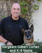 The portion of Route 15 from Second Street in Norco to Limonite Avenue in
Eastvale (~ RIV 43.664 to RIV 48.214) is named the Sergeant Gilbert
Cortez and K-9 Mattie Memorial Highway. It was nameed in memory of
Sergeant Gilbert Cortez and his K-9 partner, Mattie. Cortez was born in
1966 and raised in the City of Corona. On September 17, 1990, Mr. Cortez
began his career with the California Department of Corrections and
Rehabilitation. Mr. Cortez was first assigned to the California
Institution for Men in Chino and then transferred to Calipatria State
Prison on October 29, 1992, where he became part of the Investigative
Services Unit. While at Calipatria State Prison, Mr. Cortez was promoted
to the rank of sergeant. Sergeant Cortez then transferred to the
California Rehabilitation Center on October 29, 2001, to return to his
hometown of Corona. Sergeant Cortez held various positions at the
California Rehabilitation Center and was able to join the Investigative
Services Unit once again as an investigator. In 2011, Sergeant Cortez
became a part of the Southern Regional K-9 Unit, partnering with K-9
Mattie, who was certified to search for contraband and narcotics. Mattie
was a Belgian Malinois who was donated by a private citizen in the San
Diego area; it is not stated when Mattie was born. Sergeant Cortez and K-9
Mattie were killed in an automobile accident on Route 79 near San Felipe
Road in the County of San Diego on March 25, 2013. K-9 Mattie died at the
scene of the accident, while Sergeant Cortez succumbed to his injuries at
a local fire station before an emergency services helicopter could
transport him to a trauma center. At the time of the accident, Sergeant
Cortez was part of a convoy of state corrections K-9 officers that was en
route to inspect the La Cima Conservation Fire Camp, an inmate-staffed
firefighting outpost in a rural part of the County of San Diego. Sergeant
Cortez is survived by his wife, two children, and parents. Named by Senate
Concurrent Resolution 65 on 2/6/2014, Resolution Chapter 7.
The portion of Route 15 from Second Street in Norco to Limonite Avenue in
Eastvale (~ RIV 43.664 to RIV 48.214) is named the Sergeant Gilbert
Cortez and K-9 Mattie Memorial Highway. It was nameed in memory of
Sergeant Gilbert Cortez and his K-9 partner, Mattie. Cortez was born in
1966 and raised in the City of Corona. On September 17, 1990, Mr. Cortez
began his career with the California Department of Corrections and
Rehabilitation. Mr. Cortez was first assigned to the California
Institution for Men in Chino and then transferred to Calipatria State
Prison on October 29, 1992, where he became part of the Investigative
Services Unit. While at Calipatria State Prison, Mr. Cortez was promoted
to the rank of sergeant. Sergeant Cortez then transferred to the
California Rehabilitation Center on October 29, 2001, to return to his
hometown of Corona. Sergeant Cortez held various positions at the
California Rehabilitation Center and was able to join the Investigative
Services Unit once again as an investigator. In 2011, Sergeant Cortez
became a part of the Southern Regional K-9 Unit, partnering with K-9
Mattie, who was certified to search for contraband and narcotics. Mattie
was a Belgian Malinois who was donated by a private citizen in the San
Diego area; it is not stated when Mattie was born. Sergeant Cortez and K-9
Mattie were killed in an automobile accident on Route 79 near San Felipe
Road in the County of San Diego on March 25, 2013. K-9 Mattie died at the
scene of the accident, while Sergeant Cortez succumbed to his injuries at
a local fire station before an emergency services helicopter could
transport him to a trauma center. At the time of the accident, Sergeant
Cortez was part of a convoy of state corrections K-9 officers that was en
route to inspect the La Cima Conservation Fire Camp, an inmate-staffed
firefighting outpost in a rural part of the County of San Diego. Sergeant
Cortez is survived by his wife, two children, and parents. Named by Senate
Concurrent Resolution 65 on 2/6/2014, Resolution Chapter 7.
(Image source: Officer Down Memorial Page)
Route 15 from Limonite Avenue exit to the the northerly I-15/I-215 junction (~ RIV 48.214 to SBD 16.101) is named the "Ontario Freeway". It was named by Assembly Concurrent Resolution 10, Chapter 136, in 1989. This is because this segment goes through the City of Ontario. Ontario was named in 1882 by George B. Chaffey, who came from Ontario, Canada.
Unofficially, Route 15 from Rout 60 to the northern I-15/I-215 junction (~ RIV 51.592 to SBD 16.058) is called the "Devore Freeway". This is because this segment goes through the community of Devore.
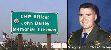 The portion of I-15 between I-10 and Rout 210, in the City of Rancho Cucamonga and the County of San Bernardino (~
SBD 2.526 to SBD 8.068) , is named the “CHP Officer John Bailey
Memorial Freeway”. This segment was named in memory of CHP
Officer John Bailey, born on June 17, 1969, in Ann Arbor, Michigan. He
graduated from Catoctin High School in Thurmont, Maryland, in 1987. Prior
to beginning his career with the Department of the California Highway
Patrol, CHP Officer Bailey enlisted in the United States Army while a
senior in high school. He honorably served his country in the United
States Army and then in the California Air National Guard. CHP Officer
Bailey served in various missions during his military career, the most
recent during Operation Iraqi Freedom, for one year in Tikrit, Iraq. CHP
Officer Bailey was a Sergeant First Class and was classified as active
duty at the time of his death. CHP Officer Bailey, badge number 14664,
joined the Department of the California Highway Patrol on November 6,
1995. On May 10, 1996, after successfully completing academy training, he
reported to the Barstow area as an officer. Officer Bailey made
significant contributions to traffic safety and assisting the motoring
public while assigned to the Barstow and Rancho Cucamonga area offices.
Officer John Bailey was killed in the line of duty during the evening
hours of February 25, 2006. He was on a traffic stop on I-15 near US 395
in the City of Hesperia, when a drunk driver collided into his patrol
motorcycle; he tragically succumbed to his injuries as a result of the
collision. Named by Senate Concurrent Resolution (SCR) 119, Resolution
Chapter 113, on 8/18/2008.
The portion of I-15 between I-10 and Rout 210, in the City of Rancho Cucamonga and the County of San Bernardino (~
SBD 2.526 to SBD 8.068) , is named the “CHP Officer John Bailey
Memorial Freeway”. This segment was named in memory of CHP
Officer John Bailey, born on June 17, 1969, in Ann Arbor, Michigan. He
graduated from Catoctin High School in Thurmont, Maryland, in 1987. Prior
to beginning his career with the Department of the California Highway
Patrol, CHP Officer Bailey enlisted in the United States Army while a
senior in high school. He honorably served his country in the United
States Army and then in the California Air National Guard. CHP Officer
Bailey served in various missions during his military career, the most
recent during Operation Iraqi Freedom, for one year in Tikrit, Iraq. CHP
Officer Bailey was a Sergeant First Class and was classified as active
duty at the time of his death. CHP Officer Bailey, badge number 14664,
joined the Department of the California Highway Patrol on November 6,
1995. On May 10, 1996, after successfully completing academy training, he
reported to the Barstow area as an officer. Officer Bailey made
significant contributions to traffic safety and assisting the motoring
public while assigned to the Barstow and Rancho Cucamonga area offices.
Officer John Bailey was killed in the line of duty during the evening
hours of February 25, 2006. He was on a traffic stop on I-15 near US 395
in the City of Hesperia, when a drunk driver collided into his patrol
motorcycle; he tragically succumbed to his injuries as a result of the
collision. Named by Senate Concurrent Resolution (SCR) 119, Resolution
Chapter 113, on 8/18/2008.
(Image source: Flikr; Find a Grave)
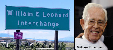 The I-15/Route 210 interchange (~ SBD
8.068) is named the "William E. Leonard Interchange". William E.
Leonard served as Chairman for both the California Highway Commission and
the California Transportation Commission (1973-1974). In 1946, William E.
Leonard joined Leonard Realty and Building Co., a firm established by his
grandfather in 1905. By the early 1960s, he was a leading developer and a
founding director of Inland Action, Inc., a group of business, government
and education leaders whose positive effect continues in the region to
this day. Over the years, Mr. Leonard's civic influence has included
chairing the California Highway Commission (1973-77) and the California
Transportation Commission (1985-93). He was active with the National
Orange Show, serving as its president in 1966. He was also a member of the
State Athletic Commission and the University of California at Riverside
Foundation. He also chaired the San Bernardino Valley College Foundation
Board and served as a trustee of the St. Bernardine's Hospital Foundation,
in addition to work on many other local boards and charities. An
investment and business consultant in recent years, he has been active
with the Inland Valley Development Authority's work to convert the former
Norton Air Force Base to a technology park and other private uses. A
veteran of World War II, he served in the U.S. Army in the Pacific
Theater, achieving the rank of First Lieutenant. He later received his
bachelor's degree in business administration from the University of
California, Berkeley. California State University, San Bernardino, honored
him and his wife in 2006 by naming the university's new federally funded
center the "William and Barbara Leonard University Transportation Center.
Named by Senate Concurrent Resolution 104, Resolution Chapter 171, in
1998.
The I-15/Route 210 interchange (~ SBD
8.068) is named the "William E. Leonard Interchange". William E.
Leonard served as Chairman for both the California Highway Commission and
the California Transportation Commission (1973-1974). In 1946, William E.
Leonard joined Leonard Realty and Building Co., a firm established by his
grandfather in 1905. By the early 1960s, he was a leading developer and a
founding director of Inland Action, Inc., a group of business, government
and education leaders whose positive effect continues in the region to
this day. Over the years, Mr. Leonard's civic influence has included
chairing the California Highway Commission (1973-77) and the California
Transportation Commission (1985-93). He was active with the National
Orange Show, serving as its president in 1966. He was also a member of the
State Athletic Commission and the University of California at Riverside
Foundation. He also chaired the San Bernardino Valley College Foundation
Board and served as a trustee of the St. Bernardine's Hospital Foundation,
in addition to work on many other local boards and charities. An
investment and business consultant in recent years, he has been active
with the Inland Valley Development Authority's work to convert the former
Norton Air Force Base to a technology park and other private uses. A
veteran of World War II, he served in the U.S. Army in the Pacific
Theater, achieving the rank of First Lieutenant. He later received his
bachelor's degree in business administration from the University of
California, Berkeley. California State University, San Bernardino, honored
him and his wife in 2006 by naming the university's new federally funded
center the "William and Barbara Leonard University Transportation Center.
Named by Senate Concurrent Resolution 104, Resolution Chapter 171, in
1998.
(Image / biographic information source: Find a Grave; CSUSBHonorary
Degree page)
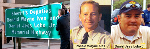 The portion of I-15 from its junction with Route 210 to Sierra
Avenue in the County of San Bernardino, California (~ SBD 8.068 to SBD
12.915) , is named the "Sheriff’s Deputies Ronald Wayne Ives and
Daniel Jess Lobo, Jr., Memorial Highway". It was named in memory of
Ronald Wayne Ives and Daniel Jess Lobo Jr. Ronald Wayne Ives was born in
Norwalk, California, in 1961. He grew up in the Cities of Buena Park and
Lakewood, and graduated from Chaffey High School in the City of Ontario,
California. He became a deputy sheriff for the San Bernardino County
Sheriff’s Department on January 2, 1996, after graduating from the
Sheriff’s Training Academy. Deputy Sheriff Ives was originally
assigned to the West Valley Detention Center before being promoted and
assigned to Patrol at the Rancho Cucamonga Sheriff’s Station in
1999. In 2002, Deputy Sheriff Ives rode his bicycle from the City of
Rancho Cucamonga to New York City. The ride raised money for the survivors
of public safety personnel who died in the September 11, 2001, attacks.
The Rancho Cucamonga Police Department honors this act annually during the
“Ron Ives Bicycle Rodeo”. On September 1, 2004, Deputy Sheriff
Ives was killed while on patrol in the Rancho Cucamonga area when an SUV
ran a red light and struck his motorcycle at approximately 50 miles per
hour; Ives was transported to Arrowhead Regional Medical Center where he
succumbed to his injuries approximately one hour later. Deputy Sheriff
Ives served with the San Bernardino County Sheriff’s Department for
eight years. Daniel Jess Lobo, Jr., was born in Pomona, California, in
1970. He grew up in the Cities of Pomona and Montclair, and graduated from
Montclair High School. Daniel Jess Lobo, Jr., became a deputy sheriff for
the San Bernardino County Sheriff’s Department on July 4, 1994,
after graduating from the Sheriff’s Training Academy. He was
originally assigned to the West Valley Detention Center before being
promoted and assigned to Patrol at the Rancho Cucamonga Sheriff’s
Station in 1998. On October 11, 2005, Deputy Sheriff Lobo was killed in a
vehicle accident with his motorcycle while responding to the scene of
another crash in the City of Rancho Cucamonga. Deputy Sheriff Lobo was
traveling behind another motor officer and a squad car when a vehicle
pulled out of a parking lot into their path. All of the responding units
had their emergency equipment activated. The other motor officer and the
squad car were able to swerve out of the car’s path, but Deputy
Sheriff Lobo’s motorcycle struck the rear of the car. He was thrown
approximately 50 feet as the result of the impact. He was flown to
Arrowhead Regional Medical Center where he succumbed to his injuries
approximately one hour later. Deputy Sheriff Lobo served with the San
Bernardino County Sheriff’s Department for 11 years. Named by
Assembly Concurrent Resolution (ACR) 123, Res. Chapter 119, Statutes of
2016 on August 16, 2016.
The portion of I-15 from its junction with Route 210 to Sierra
Avenue in the County of San Bernardino, California (~ SBD 8.068 to SBD
12.915) , is named the "Sheriff’s Deputies Ronald Wayne Ives and
Daniel Jess Lobo, Jr., Memorial Highway". It was named in memory of
Ronald Wayne Ives and Daniel Jess Lobo Jr. Ronald Wayne Ives was born in
Norwalk, California, in 1961. He grew up in the Cities of Buena Park and
Lakewood, and graduated from Chaffey High School in the City of Ontario,
California. He became a deputy sheriff for the San Bernardino County
Sheriff’s Department on January 2, 1996, after graduating from the
Sheriff’s Training Academy. Deputy Sheriff Ives was originally
assigned to the West Valley Detention Center before being promoted and
assigned to Patrol at the Rancho Cucamonga Sheriff’s Station in
1999. In 2002, Deputy Sheriff Ives rode his bicycle from the City of
Rancho Cucamonga to New York City. The ride raised money for the survivors
of public safety personnel who died in the September 11, 2001, attacks.
The Rancho Cucamonga Police Department honors this act annually during the
“Ron Ives Bicycle Rodeo”. On September 1, 2004, Deputy Sheriff
Ives was killed while on patrol in the Rancho Cucamonga area when an SUV
ran a red light and struck his motorcycle at approximately 50 miles per
hour; Ives was transported to Arrowhead Regional Medical Center where he
succumbed to his injuries approximately one hour later. Deputy Sheriff
Ives served with the San Bernardino County Sheriff’s Department for
eight years. Daniel Jess Lobo, Jr., was born in Pomona, California, in
1970. He grew up in the Cities of Pomona and Montclair, and graduated from
Montclair High School. Daniel Jess Lobo, Jr., became a deputy sheriff for
the San Bernardino County Sheriff’s Department on July 4, 1994,
after graduating from the Sheriff’s Training Academy. He was
originally assigned to the West Valley Detention Center before being
promoted and assigned to Patrol at the Rancho Cucamonga Sheriff’s
Station in 1998. On October 11, 2005, Deputy Sheriff Lobo was killed in a
vehicle accident with his motorcycle while responding to the scene of
another crash in the City of Rancho Cucamonga. Deputy Sheriff Lobo was
traveling behind another motor officer and a squad car when a vehicle
pulled out of a parking lot into their path. All of the responding units
had their emergency equipment activated. The other motor officer and the
squad car were able to swerve out of the car’s path, but Deputy
Sheriff Lobo’s motorcycle struck the rear of the car. He was thrown
approximately 50 feet as the result of the impact. He was flown to
Arrowhead Regional Medical Center where he succumbed to his injuries
approximately one hour later. Deputy Sheriff Lobo served with the San
Bernardino County Sheriff’s Department for 11 years. Named by
Assembly Concurrent Resolution (ACR) 123, Res. Chapter 119, Statutes of
2016 on August 16, 2016.
(Image sources: SBD Sheriff Office; AssemblymanMarc
Steinorth)
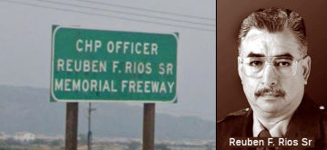 The northbound and southbound portions of Route 15, between Sierra Avenue and Kenwood Avenue,
San Bernardino County (~ SBD 12.915 to SBD R14.96), are named the "CHP
Officer Reuben F. Rios, Sr., Memorial Freeway". California Highway
Patrol Officer Reuben F. Rios, Sr. died while protecting and serving the
people of California on October 26, 1996. He was directing traffic
departing the Blockbuster Pavillion, a concert venue in Glen Helen by
Route 15, when an intoxicated motorist accelerated for a lane change and
struck Officer Rios. He was thrown onto the hood of the vehicle, then into
the windshield, and fell to the pavement with major head trauma and
internal injuries. Fellow officers immediately rushed to Officer Rios' aid
and he was transported by ambulance to the hospital, but was pronounced
dead upon his arrival. The person responsible for Officer Rios' death, was
arrested, sentenced, and convicted of vehicular manslaughter with gross
negligence supported by previous drunk driving convictions. Officer Reuben
F. Rios, Sr. had been named Officer of the Year in 1996, and had been
honored by the Latino Peace Officers Association, the San Bernardino
Chamber of Commerce, the VFW, and others. His son, Reuben, Jr., graduated
from the CHP Academy in April 1998. Named by Assembly Concurrent
Resolution 110, Chapter 93, July 12, 2000.
The northbound and southbound portions of Route 15, between Sierra Avenue and Kenwood Avenue,
San Bernardino County (~ SBD 12.915 to SBD R14.96), are named the "CHP
Officer Reuben F. Rios, Sr., Memorial Freeway". California Highway
Patrol Officer Reuben F. Rios, Sr. died while protecting and serving the
people of California on October 26, 1996. He was directing traffic
departing the Blockbuster Pavillion, a concert venue in Glen Helen by
Route 15, when an intoxicated motorist accelerated for a lane change and
struck Officer Rios. He was thrown onto the hood of the vehicle, then into
the windshield, and fell to the pavement with major head trauma and
internal injuries. Fellow officers immediately rushed to Officer Rios' aid
and he was transported by ambulance to the hospital, but was pronounced
dead upon his arrival. The person responsible for Officer Rios' death, was
arrested, sentenced, and convicted of vehicular manslaughter with gross
negligence supported by previous drunk driving convictions. Officer Reuben
F. Rios, Sr. had been named Officer of the Year in 1996, and had been
honored by the Latino Peace Officers Association, the San Bernardino
Chamber of Commerce, the VFW, and others. His son, Reuben, Jr., graduated
from the CHP Academy in April 1998. Named by Assembly Concurrent
Resolution 110, Chapter 93, July 12, 2000.
(Image source: Google Street View; California Assn of Highway Patrolmen)
The portion of I-15 from the northern I-215 junction to the Nevada state line (~ SBD 16.058 to SBD 186.238) is also named the "Mojave Freeway", as it traverses the Mojave Desert. It was named by Assembly Concurrent Resolution No. 47, Chapter 117, in 1987. Mojave is a word derived from the language of the populous and warlike Yuman tribe, and refers both to the name of the desert the route traverses, as well as a city off of Route 58.
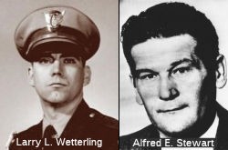 The segment of I-15
between its junction with Route 138 and Oak Hill Road (~ SBD R21.424 to
SBD R28.62), in the County of San Bernardino, is named the “CHP
Officer Larry L. Wetterling and San Bernardino County Sheriff's
Lieutenant Alfred E. Stewart Memorial Highway”. This segment
was named in honor of California Highway Patrol (CHP) Officer Larry L.
Wetterling and San Bernardino County Sheriff's Lieutenant Alfred E.
Stewart, who were killed in the line of duty on March 9, 1973. On that
date, CHP Officer Wetterling stopped to assist a driver along the
southbound side of I-15. The driver, who was a recently paroled convict,
killed Officer Wetterling and stole his patrol car. Having been notified
that there was a paroled convict out on a killing rampage, Lieutenant
Stewart answered the call and found the criminal but, unfortunately,
Lieutenant Stewart was also killed. CHP Officer Larry L. Wetterling was
born in Monmouth, IL on March 9, 1942 and had a childhood dream to serve
as a California Highway Patrol Officer. He graduated from San Bernardino
High School in 1960 and attended San Bernardino Valley College. He
graduated from the California Highway Patrol Academy in Sacramento on
March 1, 1968, and his first assignment was in the Riverside area until he
transferred to the San Bernardino area on March 12, 1970. Sheriff's
Lieutenant Alfred E. Stewart was born in Jersey City, NJ on May 24, 1933.
He was the oldest of eight children. He attended Henry Snyder High School.
He left school at 16 years of age and joined the United States Marine
Corps and served in the Korean War. Stewart was wounded in both legs in
1950 and he received an honorable discharge from the Marine Corps on
January 4, 1954. He worked for Columbia Southern Chemical Corporation.
While there, he held various union offices, including that of Union Local
President and attended the Industrial Labor School for Union Officials at
Saint Peter's Prep, in Jersey City. He received an honorable discharge
from the Marine Reserve as Staff Sergeant in 1965 after 14 years of
service. He joined the North Bergen Police Force in North Bergen, NJ in
1960. He became a detective and was a member of the Vice Squad. In the
Police Detective Bureau, he worked in criminal investigation and arrests.
Lieutenant Stewart and his family moved to California in 1964, and he was
hired by the San Bernardino County Sheriff's Department, where he was one
of the founding members of the California Narcotics Officer's Association,
serving as the eighth president in 1972. In 1973, the California Narcotics
Officer's Association created the Alfred E. Stewart Memorial Award to
memorialize Lieutenant Stewart by honoring individual achievement of
working narcotic officers. Named by Assembly Concurrant Resolution (ACR)
127, 8/30/2010, Resolution Chapter 110.
The segment of I-15
between its junction with Route 138 and Oak Hill Road (~ SBD R21.424 to
SBD R28.62), in the County of San Bernardino, is named the “CHP
Officer Larry L. Wetterling and San Bernardino County Sheriff's
Lieutenant Alfred E. Stewart Memorial Highway”. This segment
was named in honor of California Highway Patrol (CHP) Officer Larry L.
Wetterling and San Bernardino County Sheriff's Lieutenant Alfred E.
Stewart, who were killed in the line of duty on March 9, 1973. On that
date, CHP Officer Wetterling stopped to assist a driver along the
southbound side of I-15. The driver, who was a recently paroled convict,
killed Officer Wetterling and stole his patrol car. Having been notified
that there was a paroled convict out on a killing rampage, Lieutenant
Stewart answered the call and found the criminal but, unfortunately,
Lieutenant Stewart was also killed. CHP Officer Larry L. Wetterling was
born in Monmouth, IL on March 9, 1942 and had a childhood dream to serve
as a California Highway Patrol Officer. He graduated from San Bernardino
High School in 1960 and attended San Bernardino Valley College. He
graduated from the California Highway Patrol Academy in Sacramento on
March 1, 1968, and his first assignment was in the Riverside area until he
transferred to the San Bernardino area on March 12, 1970. Sheriff's
Lieutenant Alfred E. Stewart was born in Jersey City, NJ on May 24, 1933.
He was the oldest of eight children. He attended Henry Snyder High School.
He left school at 16 years of age and joined the United States Marine
Corps and served in the Korean War. Stewart was wounded in both legs in
1950 and he received an honorable discharge from the Marine Corps on
January 4, 1954. He worked for Columbia Southern Chemical Corporation.
While there, he held various union offices, including that of Union Local
President and attended the Industrial Labor School for Union Officials at
Saint Peter's Prep, in Jersey City. He received an honorable discharge
from the Marine Reserve as Staff Sergeant in 1965 after 14 years of
service. He joined the North Bergen Police Force in North Bergen, NJ in
1960. He became a detective and was a member of the Vice Squad. In the
Police Detective Bureau, he worked in criminal investigation and arrests.
Lieutenant Stewart and his family moved to California in 1964, and he was
hired by the San Bernardino County Sheriff's Department, where he was one
of the founding members of the California Narcotics Officer's Association,
serving as the eighth president in 1972. In 1973, the California Narcotics
Officer's Association created the Alfred E. Stewart Memorial Award to
memorialize Lieutenant Stewart by honoring individual achievement of
working narcotic officers. Named by Assembly Concurrant Resolution (ACR)
127, 8/30/2010, Resolution Chapter 110.
(Image source: Find a Grave, Calif. Narcotic Officers Assn)
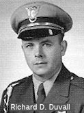 The portion of I-15 (formerly
known as Route 66) in the City of Victorville between the US 395
interchange and the exit of D Street (~ SBD 31.971 to SBD 96.544) is named
the “CHP Officer Richard D. Duvall Memorial Highway”.
This segment was named in memory of California Highway Patrol (CHP)
Officer Richard D. Duvall, who died on February 23, 1960, on a remote
stretch of what was then US 66. Officer Duvall was shot and killed during
a routine traffic stop by an escaped convict from the California State
Prison at San Quentin who, unbeknownst to Officer Duvall, had also just
fled the scene of a robbery. Born on June 19, 1933, in San Leandro, Duvall
was a football star in high school and served two years in the United
States Marine Corps. He attended Armstrong College of Business, and then
attended the CHP Academy and took his first assignment at the Victorville
substation. Officer Duvall served with the CHP in Victorville for two
years prior to his tragic death. Officer Duvall's death is a reminder of
the dangers that our men and women in uniform face on a daily basis, and
his sacrifice for the people of the State of California should not be
forgotten. Named by Senate Concurrent Resolution (SCR) 69, Resolution
Chapter 65, on 8/4/2010.
The portion of I-15 (formerly
known as Route 66) in the City of Victorville between the US 395
interchange and the exit of D Street (~ SBD 31.971 to SBD 96.544) is named
the “CHP Officer Richard D. Duvall Memorial Highway”.
This segment was named in memory of California Highway Patrol (CHP)
Officer Richard D. Duvall, who died on February 23, 1960, on a remote
stretch of what was then US 66. Officer Duvall was shot and killed during
a routine traffic stop by an escaped convict from the California State
Prison at San Quentin who, unbeknownst to Officer Duvall, had also just
fled the scene of a robbery. Born on June 19, 1933, in San Leandro, Duvall
was a football star in high school and served two years in the United
States Marine Corps. He attended Armstrong College of Business, and then
attended the CHP Academy and took his first assignment at the Victorville
substation. Officer Duvall served with the CHP in Victorville for two
years prior to his tragic death. Officer Duvall's death is a reminder of
the dangers that our men and women in uniform face on a daily basis, and
his sacrifice for the people of the State of California should not be
forgotten. Named by Senate Concurrent Resolution (SCR) 69, Resolution
Chapter 65, on 8/4/2010.
(Image source: CHP Memorial Page)
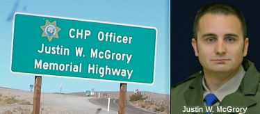 The portion of I-15 between
Wild Rash Road and Hodge Road from Wild Wash Road (SD 55.957) to Hodge
Road (SD 60.159) in the County of San Bernardino is officially designated
the "CHP Officer Justin W. McGrory Memorial Highway" It was named
in memory of CHP Officer Justin Wayne McGrory. McGrory was born June 4,
1982, in Beaufort, South Carolina. He graduated from Silverado High School
in Victorville, California, in 2000 and attended American River College in
Sacramento, California. Prior to joining the California Highway Patrol
(CHP), CHP Officer McGrory served in the United States Air Force in Little
Rock, Arkansas. Upon discharge, he joined the Air Force Reserves at Travis
Air Force Base in Fairfield, California, and was activated for a
four-month tour of duty in Afghanistan in 2006. In 2007, CHP Officer
McGrory, badge number 18606, graduated from the CHP Academy and was
assigned to the Baldwin Park Area Office. After 18 months, McGrory was
voluntarily transferred to the Barstow Area where he spent the remainder
of his career. CHP Officer McGrory had only been a CHP Officer for a few
years and did not have any collateral duties; however, because of his
exceptional skills as a CHP Officer, he was scheduled to attend a field
training evaluation program class to become a field training officer to
train new cadets. On June 27, 2010, at approximately 3:38 a.m., CHP
Officer McGrory was issuing a field sobriety test on the shoulder of the
I-15 freeway when a red Pontiac G6 veered onto the shoulder and struck
him. CHP Officer McGrory's partner broadcast an 11-99 (officer down) and
immediately began CPR. Two other CHP officers and a sergeant arrived on
the scene minutes later and assisted with CPR. CHP Officer McGrory was
airlifted to Saint Mary's Regional Medical Center in Apple Valley,
California, but unfortunately succumbed to his injuries at approximately
4:55 a.m. He was admired for his sense of humor, his ability to "write a
citation without managing to ruin the violator's day," devotion to his
family and career, confidence, charm, poise, and for being an all around
great man. Named by Assembly Concurrent Resolution 37, Resolution Chapter
49, on July 11, 2011.
The portion of I-15 between
Wild Rash Road and Hodge Road from Wild Wash Road (SD 55.957) to Hodge
Road (SD 60.159) in the County of San Bernardino is officially designated
the "CHP Officer Justin W. McGrory Memorial Highway" It was named
in memory of CHP Officer Justin Wayne McGrory. McGrory was born June 4,
1982, in Beaufort, South Carolina. He graduated from Silverado High School
in Victorville, California, in 2000 and attended American River College in
Sacramento, California. Prior to joining the California Highway Patrol
(CHP), CHP Officer McGrory served in the United States Air Force in Little
Rock, Arkansas. Upon discharge, he joined the Air Force Reserves at Travis
Air Force Base in Fairfield, California, and was activated for a
four-month tour of duty in Afghanistan in 2006. In 2007, CHP Officer
McGrory, badge number 18606, graduated from the CHP Academy and was
assigned to the Baldwin Park Area Office. After 18 months, McGrory was
voluntarily transferred to the Barstow Area where he spent the remainder
of his career. CHP Officer McGrory had only been a CHP Officer for a few
years and did not have any collateral duties; however, because of his
exceptional skills as a CHP Officer, he was scheduled to attend a field
training evaluation program class to become a field training officer to
train new cadets. On June 27, 2010, at approximately 3:38 a.m., CHP
Officer McGrory was issuing a field sobriety test on the shoulder of the
I-15 freeway when a red Pontiac G6 veered onto the shoulder and struck
him. CHP Officer McGrory's partner broadcast an 11-99 (officer down) and
immediately began CPR. Two other CHP officers and a sergeant arrived on
the scene minutes later and assisted with CPR. CHP Officer McGrory was
airlifted to Saint Mary's Regional Medical Center in Apple Valley,
California, but unfortunately succumbed to his injuries at approximately
4:55 a.m. He was admired for his sense of humor, his ability to "write a
citation without managing to ruin the violator's day," devotion to his
family and career, confidence, charm, poise, and for being an all around
great man. Named by Assembly Concurrent Resolution 37, Resolution Chapter
49, on July 11, 2011.
(Image source: Find a Grave)
The portion of this route from Barstow to the Nevada state line (i.e., former US 91/466) (~ SBD 70.977 to SBD 186.238) was once named the "Barstow-Jean Highway" (Resolution Chapter 369, 1925). This name comes from the principle cites at the time of naming: Barstow CA and Jean NV (Stateline was nothing back in 1925, which was before the legalization of gambling).
Prior to the 1987 definition, this segment was named the "Barstow Freeway" (State Highway Commission, November 1958). This was named for the city of Barstow. Barstow refers to the city of Barstow, which was named in 1886 by the Santa Fe Railroad for its president, William Barstow Strong.
 Named Structures
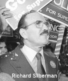 Bridge 57-919, in San Diego county at Claremont Mesa Blvd. (~ SD R9.988), is/was named the "Richard T.
Silberman Bridge" (the current status is unclear). It was built in
1985, and named by Assembly Concurrent Resolution 67, Chapter 107, in
1987. Richard Silberman was once a state Director of Finance, a Secretary
of Business, Transportation and Housing and the Governor’s Chief of
Staff. Silberman helped Jerry Brown get elected governor. Silberman was
once one of San Diego’s biggest movers and shakers. He bought and
sold banks, chaired the downtown redevelopment agency and helped found Old
Town’s Bazaar del Mundo. He was one of the founding partners in
Jack-in the Box, and was associated with Ralston Purina in executive
capacities after their acquisition of Foodmaker. He was also associated
with the California First Bank (subsequently acquired by the Bank of
Tokyo) as President. In 1989 (after the bridge was named), Silberman (who
was at one time married to ex-San Diego Mayer Susan Golding) was busted in an FBI sting for laundering $300,000 in what he believed was Colombian drug money. He was convicted a year later and sentenced to 46
months in prison. The sordid story can be found here. Since his release from federal prison three years ago, he divorced Golding and moved to San Francisco. He
has been involved in consulting for the Mountain Mike’s Pizza chain.
But while in prison, he and Golding quietly divorced. He is currently
president of Operating Advisors Inc., where he provides strategic
planning, financial and acquisition advisory services. This is a prime
example of why you need to be careful whom you name bridges after.
According to Google Street View, there appears to be no sign on the
bridge. Acccording to the LA Times, souvenir hunters took the signs soon after Silberman’s criminal problems, and Caltrans figures new signs would
only suffer a similar fate. Note that the sign played a tiny role in the
drug-money laundering case that landed him in jail. When the FBI agents
wiretapping Chris Petti first started hearing the name Silberman, they
assumed he was a money-launderer or minor crime figure out of Los Angeles
(not a big-time politico from San Diego). However, an FBI secretary who
had been typing up the wiretap transcripts happened to notice the bridge
sign on her way to work. She asked her bosses: Do you think the Silberman
on the wiretaps and the Silberman on the bridge could possibly be the same
guy? The agents did some checking. Bingo. Suddenly the case got more
important. As such, Silberman joins the small group of individuals who
have had highways named after them, only to bring disgrace upon that name
afterward. See Oscar Rios Highway, Route 129.
Bridge 57-919, in San Diego county at Claremont Mesa Blvd. (~ SD R9.988), is/was named the "Richard T.
Silberman Bridge" (the current status is unclear). It was built in
1985, and named by Assembly Concurrent Resolution 67, Chapter 107, in
1987. Richard Silberman was once a state Director of Finance, a Secretary
of Business, Transportation and Housing and the Governor’s Chief of
Staff. Silberman helped Jerry Brown get elected governor. Silberman was
once one of San Diego’s biggest movers and shakers. He bought and
sold banks, chaired the downtown redevelopment agency and helped found Old
Town’s Bazaar del Mundo. He was one of the founding partners in
Jack-in the Box, and was associated with Ralston Purina in executive
capacities after their acquisition of Foodmaker. He was also associated
with the California First Bank (subsequently acquired by the Bank of
Tokyo) as President. In 1989 (after the bridge was named), Silberman (who
was at one time married to ex-San Diego Mayer Susan Golding) was busted in an FBI sting for laundering $300,000 in what he believed was Colombian drug money. He was convicted a year later and sentenced to 46
months in prison. The sordid story can be found here. Since his release from federal prison three years ago, he divorced Golding and moved to San Francisco. He
has been involved in consulting for the Mountain Mike’s Pizza chain.
But while in prison, he and Golding quietly divorced. He is currently
president of Operating Advisors Inc., where he provides strategic
planning, financial and acquisition advisory services. This is a prime
example of why you need to be careful whom you name bridges after.
According to Google Street View, there appears to be no sign on the
bridge. Acccording to the LA Times, souvenir hunters took the signs soon after Silberman’s criminal problems, and Caltrans figures new signs would
only suffer a similar fate. Note that the sign played a tiny role in the
drug-money laundering case that landed him in jail. When the FBI agents
wiretapping Chris Petti first started hearing the name Silberman, they
assumed he was a money-launderer or minor crime figure out of Los Angeles
(not a big-time politico from San Diego). However, an FBI secretary who
had been typing up the wiretap transcripts happened to notice the bridge
sign on her way to work. She asked her bosses: Do you think the Silberman
on the wiretaps and the Silberman on the bridge could possibly be the same
guy? The agents did some checking. Bingo. Suddenly the case got more
important. As such, Silberman joins the small group of individuals who
have had highways named after them, only to bring disgrace upon that name
afterward. See Oscar Rios Highway, Route 129.
(Image source: San Diego Reader)
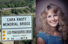 Bridge 57-106, the Penasquitos Creek Bridge (SD M017.82) is officially
named the "Cara Knott Memorial Bridge". It was built in 1964, and
named by Assembly Concurrent Resolution No. 13, Chapter 75, in 1995. Cara
Knott was a 20-year-old San Diego State University student. On the night
of Dec. 27, 1986, she was pulled over by a veteran CHP officer in San
Diego, forced to drive down a secluded road and was murdered by the CHP
officer. Her parents later sought help from the CHP when their daughter
was late in returning to their El Cajon home from visiting her sick
boyfriend in Escondido. Her father was there when her body was found below
what is now called the Cara Knott Memorial Bridge. In an odd coincidence,
Sam Knott, who became a victims' rights crusader after his daughter Cara's
murder, died in December 2000 near the spot where she was beaten and
strangled by a California Highway Patrol officer Craig Peyer. Knott had
been picking up trash in the area where his daughter was killed. He turned
that site near I-15 off Mercy Road and north of Scripps Poway Parkway into
a memorial dedicated to victims of violence. This is just N of where Route 163 and I-15 intersect.
Bridge 57-106, the Penasquitos Creek Bridge (SD M017.82) is officially
named the "Cara Knott Memorial Bridge". It was built in 1964, and
named by Assembly Concurrent Resolution No. 13, Chapter 75, in 1995. Cara
Knott was a 20-year-old San Diego State University student. On the night
of Dec. 27, 1986, she was pulled over by a veteran CHP officer in San
Diego, forced to drive down a secluded road and was murdered by the CHP
officer. Her parents later sought help from the CHP when their daughter
was late in returning to their El Cajon home from visiting her sick
boyfriend in Escondido. Her father was there when her body was found below
what is now called the Cara Knott Memorial Bridge. In an odd coincidence,
Sam Knott, who became a victims' rights crusader after his daughter Cara's
murder, died in December 2000 near the spot where she was beaten and
strangled by a California Highway Patrol officer Craig Peyer. Knott had
been picking up trash in the area where his daughter was killed. He turned
that site near I-15 off Mercy Road and north of Scripps Poway Parkway into
a memorial dedicated to victims of violence. This is just N of where Route 163 and I-15 intersect.
On February 20, 2019, Cynthia Knott noted that the
signs had been updated to include Cara's full name (vs "Knott Memorial
Bridge", the original name). She wrote: "THANK YOU
#CalTransDistrict11, Gustavo Dallarda, Marcelo Peinado, Shahin Sepassi,
and the entire CalTrans team for making this right and changing the signs
to reflect Cara’s name. Joyce Knott, Cynthia Knott, Cheryl Knott,
John Knott, Oreet Herbst, Sam Weick, Buddy Weick, and the entire extended
Knott Family thanks you. My daddy, Sam Knott, would be SO touched and
grateful for this act of kindness. My mama, Joyce Knott, noted the signs
were erected around Cara’s Birthday - February 11th. You
have no idea how much this means to us all. THANK YOU! " Cynthia provides
links to some articles on the original case: "An Emotional Judge Gives Peyer 25 Years for Killing Cara Knott" (LA Times, 8/4/1988); "Remembering The Monster" (SD Magazine, 3/2008); "Killerin
1986 Knott case denied parole" (SD Union Tribune, 1/11/2012). These
articles noted the perpetrator was and remains the first and only
California Highway Patrolman convicted of murder on duty. His crime shook
the very foundation of public faith in law enforcement, and its impact
remains a permanent scar on the public psyche. During his first failed bid
for parole in January 2004, the female prison guard who escorted him into
the hearing was shocked to realize he was the man her mother warned her
about when she was just starting to drive. The details of his crime may
fade, but the killer is one of California’s most notorious
boogeymen. Fighting the perpetrator slowly killed Cara’s father, her
eldest sister, Cynthia, told the parole board. He robbed their family of
all joy. The strain drainied her mother, Joyce, who suffered a heart
episode that prevented her from joining her family at the second parole
hearing. “I am the voice of my father,” Cynthia Knott told the
board. “I am the voice of my mother.” He was denied parole
again in 2012. Sam Knott worked for years to establish the Cara Knott
Memorial Oak Garden — now called the San Diego Crime Victims Oak Garden — in the Los Peñasquitos Canyon Preserve, turning the scene of his daughter’s slaying into
something far more serene.
(Source: Cynthia Knott, Facebook poage, 2/20/2019; "RememberingThe
Monster" (SD Magazine, 3/2008))
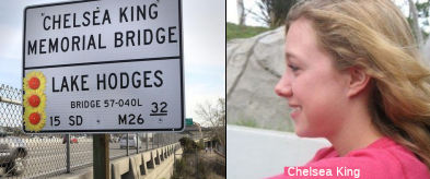 The I-15 bridge over Lake Hodges in San Diego
County (SD M026.20) is named the "Chelsea King Memorial Bridge".
Named in memory of Chelsea King, a 17-year-old Poway High School student,
who disappeared after going for a run in Rancho Bernardo Park in San Diego
County on February 25, 2010. After a search by law enforcement and
thousands of citizen search volunteers, Chelsea King’s body was
found near Lake Hodges, and it was determined her life had been tragically
taken by a violent sex offender. A man who was convicted of violently
molesting a 13-year-old in 2000, but was freed after only five years in
prison, has pled guilty to the crime. Chelsea King will always be
remembered by her community for her compassionate heart and positive
spirit, whether for helping plan a prom for developmentally disabled
youth, packing relief boxes for those in need in Africa, or serving as a
peer counselor at her school. Chelsea King was an avid cross country
runner, a gifted student, and a loving daughter and sister, whose life was
untimely and tragically ended.Named by Assembly Concurrent Resolution 165,
Resolution Chapter 134, on September 18, 2012.
The I-15 bridge over Lake Hodges in San Diego
County (SD M026.20) is named the "Chelsea King Memorial Bridge".
Named in memory of Chelsea King, a 17-year-old Poway High School student,
who disappeared after going for a run in Rancho Bernardo Park in San Diego
County on February 25, 2010. After a search by law enforcement and
thousands of citizen search volunteers, Chelsea King’s body was
found near Lake Hodges, and it was determined her life had been tragically
taken by a violent sex offender. A man who was convicted of violently
molesting a 13-year-old in 2000, but was freed after only five years in
prison, has pled guilty to the crime. Chelsea King will always be
remembered by her community for her compassionate heart and positive
spirit, whether for helping plan a prom for developmentally disabled
youth, packing relief boxes for those in need in Africa, or serving as a
peer counselor at her school. Chelsea King was an avid cross country
runner, a gifted student, and a loving daughter and sister, whose life was
untimely and tragically ended.Named by Assembly Concurrent Resolution 165,
Resolution Chapter 134, on September 18, 2012.
(Image source: SD Union Tribune; SDUnion
Tribune)
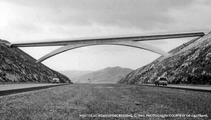 Bridge 57-870, at the W. Lilac Road overcrossing in San Diego county (SD R044.24), is named the "Walter F. Maxwell Memorial Bridge".
It was built in 1978, and was named by Senate Concurrent Resolution 14,
Chapter 68, in 1981. Walter F. Maxwell, (1909-1980), civil engineer, built
over 750 bridges and overpasses in southern California.
Bridge 57-870, at the W. Lilac Road overcrossing in San Diego county (SD R044.24), is named the "Walter F. Maxwell Memorial Bridge".
It was built in 1978, and was named by Senate Concurrent Resolution 14,
Chapter 68, in 1981. Walter F. Maxwell, (1909-1980), civil engineer, built
over 750 bridges and overpasses in southern California.
Here is the history of this span: Nearly 700-feet long and rising 122 feet above the I-15 north of Escondido, the West Lilac Road Overcrossing provides a dramatic connection between the communities surrounding Valley Center and Bonsall. It may be one the best known bridges in the county, but it often provokes the question: Why was a structure of this magnitude built in such a sparsely populated, semi-rural location? The answer is: Jacob Dekama.Engineer Jon Mehtlan explains, “A more typical slab bridge built a half mile north or south could have accomplished the same task for much less money. But then-Director of Caltrans District 11, Jacob Dekema, liked to do something iconic every once in a while. Dekema, often referred to as the father of San Diego’s highway system, brought great vision and direction to the region. And in the 1970s highway funding was available to support the resulting projects. During the construction of West Lilac Road Bridge, Mehtlan was an Assistant Bridge Engineer at Caltrans doing fieldwork under Structure Representative John Day.He recalls that the West Lilac Road overcrossing was a complicated undertaking. A product of the Caltrans Bridge Department, it was designed by engineers Fred G. Michaels and John Suwada (with architecture consulting by William Wells) in 1973. Mehtlan recalls that the project sat on the shelf for a few years, during which time Michaels and Suwada left Caltrans, taking their notes with them. This left the field engineers to their own devices and many engineering calculations were worked out onsite. Nothing on the bridge was symmetrical; the arch, the sloping girders all varied lineally from one end to the other, so calculations had to be made inch-by-inch the entire length of the bridge, all before the computer age. While the location of the bridge enhances its visual impact, the terrain presented its own challenges, requiring three times the effort to manage lines and grade. One contractor employee found the project so frustrating that he left the business entirely. Prior to construction of the bridge, the hill existed with a cut for the new I-15 travel lanes. Then 11 million cubic yards of rock had to be excavated to prepare the slopes for the installation of the bridge. Because the bridge was cast in place, the falsework had to be installed according to very precise field calculations that took weeks to do.
The bridge has three spans. One, the arch, is
conventionally reinforced with interior rebar. The two approach spans,
however, were post-tensioned.When the cables in the superstructure were
pulled tight on the day before Thanksgiving, the bridge’s weight was
transferred onto the arch, which was still being supported by falsework.
Field calculations indicated that transferring this load would cause the
falsework at the center of the arch to move an acceptable 1-3/8 inches.
When the crew returned from the four-day holiday, however, they found that
the falsework had become so tightly compacted and mangled that it had to
be removed with cutting torches. In all, the project took nearly two years
and $1.5 million to complete. It opened in 1978.
(Source: FB Post by Kim Sturmer, 3/28/2019; SD History Center)
 Bridge 54-0909 on I-15, the I-15/I-10 separation in San
Bernardino County near Ontario (SBD 009.94), is named the "Daniel D.
Mikesell Interchange". It was built in 1975, and was named in Senate
Concurrent Resolution 64, Chapter 84, in 1980. Daniel D. Mikesell was born
on March 1910 in Shawnee, Oklahoma. He attended UCLA and married Gabrielle
Lucas, a former Miss Ontario in 1936. He joined the San Bernardino County
Board of Supervisors in 1954 and served until he was elected Mayor of
Ontario in 1960. Re-elected to the Board of Supervisors in 1962, he
remained there until his retirement in 1974. He died on November 12, 2007
in Ontario. Known as a consummate politician, he was considered an
authority on aviation and transportation. He was instrumental in the
transfer of the Ontario Airport to the County of Los Angeles and the
I-10/I-15 freeway interchange is named in his honor for his decades-long
effort to construct the link between Ontario and Fontana. In particular,
Mikesell exerted exceptional effort beginning in 1955 to have the Devore
Cutoff included in the California Freeway and Expressway System.
Bridge 54-0909 on I-15, the I-15/I-10 separation in San
Bernardino County near Ontario (SBD 009.94), is named the "Daniel D.
Mikesell Interchange". It was built in 1975, and was named in Senate
Concurrent Resolution 64, Chapter 84, in 1980. Daniel D. Mikesell was born
on March 1910 in Shawnee, Oklahoma. He attended UCLA and married Gabrielle
Lucas, a former Miss Ontario in 1936. He joined the San Bernardino County
Board of Supervisors in 1954 and served until he was elected Mayor of
Ontario in 1960. Re-elected to the Board of Supervisors in 1962, he
remained there until his retirement in 1974. He died on November 12, 2007
in Ontario. Known as a consummate politician, he was considered an
authority on aviation and transportation. He was instrumental in the
transfer of the Ontario Airport to the County of Los Angeles and the
I-10/I-15 freeway interchange is named in his honor for his decades-long
effort to construct the link between Ontario and Fontana. In particular,
Mikesell exerted exceptional effort beginning in 1955 to have the Devore
Cutoff included in the California Freeway and Expressway System.
(Image source: UCR California Digital Newspaper Collection, SB Sun, 5/24/1974, Page 17)
 As I-15 crosses the desert, one of the exits is for Zzyzx Road (~ SBD
R130.593). The history behind this road and the area is fascinating. The road leads to Zzyzx Springs, which was started in 1944 on illegally appropriate
government land by Curtis Howe Springer who erected a 60-room hotel, a
church, a health spa with mineral baths in the shape of a cross, a castle,
a radio station and several other buildings. For thirty years Springer
broadcast a daily religious and health program from a radio studio at
Zzyzx Springs. In 1974, federal marshals finally arrested Springer for
alleged violations of food and drug laws and unauthorized use of federal
land. Since 1976 Zzyzx Springs, now simply known as Zzyzx, has functioned
as the Desert Studies Center, a teaching and research station administered
by the California State University system. The name Zzyzx was made up by
Springer. Here's another article on Zzyzx.
As I-15 crosses the desert, one of the exits is for Zzyzx Road (~ SBD
R130.593). The history behind this road and the area is fascinating. The road leads to Zzyzx Springs, which was started in 1944 on illegally appropriate
government land by Curtis Howe Springer who erected a 60-room hotel, a
church, a health spa with mineral baths in the shape of a cross, a castle,
a radio station and several other buildings. For thirty years Springer
broadcast a daily religious and health program from a radio studio at
Zzyzx Springs. In 1974, federal marshals finally arrested Springer for
alleged violations of food and drug laws and unauthorized use of federal
land. Since 1976 Zzyzx Springs, now simply known as Zzyzx, has functioned
as the Desert Studies Center, a teaching and research station administered
by the California State University system. The name Zzyzx was made up by
Springer. Here's another article on Zzyzx.
This route also has the following Safety Roadside Rest Areas and Scenic Overlooks:
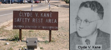 Clyde V. Kane
(Midway) (~ SBD R107.376), in San Bernardino County, 30 mi E of Barstow. It was named after Clyde V. Kane, who joined the Division of Highways in 1928 as a
draftsman, spent 24 years in District 8 (San Bernardino and Riverside)
counties, advancing through the ranks to become Assistant District
Engineer in 1947. In 1952, he was assigned as District 1 Engineer, and
then moved back to District 8 as District Engineer in March 1953,
continuing until his retirement on January 30, 1970, after 42 years of
service. He was one of the top designers for I-15 and I-40. He was very
supportive and was behind landscaping our highways, thus the trees
planted along I-15. He was born in Albuquerque NM and attended grade and
high school in Lakeport CA. He graduated from UC Berkeley in 1927 with a
BS in Civil Engineering. In 1922, he did surveys for the SP Railroad in
Imperial County and the State of Oregon. During WWII, he served for a
year as chief of the engineering division for the construction of a
portion of the Pan American Highway. He was responsible for early
projects such as widening Foothill Blvd and the paving of S "E" Street.
He led the work to complete most of the major freeway routes in the
district.
Clyde V. Kane
(Midway) (~ SBD R107.376), in San Bernardino County, 30 mi E of Barstow. It was named after Clyde V. Kane, who joined the Division of Highways in 1928 as a
draftsman, spent 24 years in District 8 (San Bernardino and Riverside)
counties, advancing through the ranks to become Assistant District
Engineer in 1947. In 1952, he was assigned as District 1 Engineer, and
then moved back to District 8 as District Engineer in March 1953,
continuing until his retirement on January 30, 1970, after 42 years of
service. He was one of the top designers for I-15 and I-40. He was very
supportive and was behind landscaping our highways, thus the trees
planted along I-15. He was born in Albuquerque NM and attended grade and
high school in Lakeport CA. He graduated from UC Berkeley in 1927 with a
BS in Civil Engineering. In 1922, he did surveys for the SP Railroad in
Imperial County and the State of Oregon. During WWII, he served for a
year as chief of the engineering division for the construction of a
portion of the Pan American Highway. He was responsible for early
projects such as widening Foothill Blvd and the paving of S "E" Street.
He led the work to complete most of the major freeway routes in the
district. Note: In January 2013, the CTC authorized $11,273,000 to upgrade the aging and heavily used northbound and southbound Kane Rest Area. This work will reconstruct, expand, and modernize comfort stations, walkways, parking, and utilities.
In August 2018, the CTC authorized $1,100,000 in
emergency SHOPP funding for San Bernardino 08-SBd-15 160.8/161.1:
Route 15 Near Baker, at Valley Wells Safety Roadside Rest Area (SRRA).
Four years of drought have lead to a reduction in groundwater and
water quality at the Valley Wells SRRA, forcing this heavily used
facility to be closed to public use. An adjacent SRRA is also closed
for similar reasons resulting in a very large section of isolated
Route 15 without these types of services for the traveling public.
This project will abandon the existing failing well, drill a new well,
and connect to the existing system, allowing the facility to be
reopened.
(Source: August 2018 CTC Agenda Item 2.5f.(2)
Item 19)
 National Trails
 This route is part of the De Anza National Historic Trail.
 The portion of this route from the northern I-15/I-215
junction to the Nevada state line (former US 91) is part of the "Arrowhead
Trail
(Ocean to Ocean Trail)". It was named by Resolution Chapter 369 in
1925.
The portion of this route from the northern I-15/I-215
junction to the Nevada state line (former US 91) is part of the "Arrowhead
Trail
(Ocean to Ocean Trail)". It was named by Resolution Chapter 369 in
1925.
 The original surface routing replaced by I-15 (i.e., old US 66)
was part of the "National Old Trails Road".
The original surface routing replaced by I-15 (i.e., old US 66)
was part of the "National Old Trails Road".
 The original surface routing replaced by I-15 (i.e., old US 66) was part of the "New Santa Fe Trail".

 The original surface routing replaced by I-15
(i.e., old US 66) appears to have been part of the "National Park to
Park Highway", and the "Pikes Peak Ocean to Ocean Highway".
The original surface routing replaced by I-15
(i.e., old US 66) appears to have been part of the "National Park to
Park Highway", and the "Pikes Peak Ocean to Ocean Highway".
 All of original US 395 (i.e., the portion of I-15 from US 395 to the northern I-15/I-215 junction, and the portion of I-15 from the
southern I-15/I-215 junction to Route 163) was part of the "Three Flags
Highway".
All of original US 395 (i.e., the portion of I-15 from US 395 to the northern I-15/I-215 junction, and the portion of I-15 from the
southern I-15/I-215 junction to Route 163) was part of the "Three Flags
Highway".
 Business Routes
 Scenic Route
[SHC 263.3] From Route 76 near the San Luis Rey River to Route 91 near Corona; and from Route 138 near Cajon Pass to Route 138 near Cajon Pass; and from Route 58 near Barstow to Route 127 near Baker.
Interstate SubmissionsThe portion from Route 10 to the Nevada State line was approved as chargeable Interstate on 7/7/1947; Route 8 to Route 10 was approved as chargeable interstate in December 1968 using the Route 215 routing; this was changed to a western routing in February 1972, and there was a correction around Lake Elsinore in July 1978. The designation I-15 was proposed in 1957, and suprisingly, the California Department of Highways never proposed anything else.
 Classified Landcaped Freeway
The following segments are designated as Classified Landscaped Freeway:
| County | Route | Starting PM | Ending PM |
| San Diego | 15 | R0.14 | 1.50 |
| San Diego | 15 | 1.50 | 1.65 |
| San Diego | 15 | 1.65 | 2.25 |
| San Diego | 15 | 2.25 | 2.33 |
| San Diego | 15 | R3.20 | R6.27 |
| San Diego | 15 | R6.44 | M12.15 |
| San Diego | 15 | M14.51 | M16.19 |
| San Diego | 15 | M17.99 | M18.36 |
| San Diego | 15 | M18.53 | M19.51 |
| San Diego | 15 | M19.51 | M21.92 |
| San Diego | 15 | M21.92 | M22.75 |
| San Diego | 15 | M22.75 | M25.06 |
| San Diego | 15 | M25.11 | M26.20 |
| San Diego | 15 | M26.32 | M32.08 |
| San Diego | 15 | R32.66 | R33.09 |
| Riverside | 15 | 3.02 | 5.40 |
| Riverside | 15 | 5.65 | 7.77 |
| Riverside | 15 | 7.82 | 8.18 |
| Riverside | 15 | 20.65 | 21.26 |
| Riverside | 15 | 40.09 | 42.05 |
| Riverside | 15 | 42.23 | 46.14 |
| San Bernardino | 15 | 5.27 | 5.99 |
| San Bernardino | 15 | 7.56 | 10.11 |
| San Bernardino | 15 | 40.30 | 41.09 |
| San Bernardino | 15 | 41.89 | 42.83 |
| San Bernardino | 15 | 43.21 | 43.48 |
| San Bernardino | 15 | 71.38 | 71.88 |
| San Bernardino | 15 | 73.34 | 73.70 |
| San Bernardino | 15 | 74.15 | 75.02 |
Historical RouteAs of March 2008, the California Transportation Committee unanimously approved the designation of former US 395 as a historic route from San Diego to the Oregon border. It is still pending approval by the legislature and the governor. However, anticipating approval, San Diego County Supervisor Bill Horn approved $4,000 for the 31 signs that now mark old 395 in his district -- from Vista to the Bonsall Bridge, through downtown Fallbrook, to Rainbow.
On July 8, 2008, Resolution Chapter 79 officially designated specified sections of former US Highway Route 395 as Historic US Highway 395. The resolution noted that former US 395 was a scenic stretch of highway that ran through historic areas of the County of Riverside and provided the only direct route from San Diego to the Lake Tahoe region and northern Nevada, before heading back into California on its way north to Oregon and all the way into Canada. While former US 395 remains largely intact through the Counties of Inyo, Mono, Sierra, Lassen, and Modoc, only sections of former US 395 still exist in portions of the County of San Diego and the high desert area of the County of San Bernardino; most of the former highway route has been replaced by I-15 and I-215 in the Counties of San Diego, Riverside, and San Bernardino. US 395, which remains as I-15 and I-215, was the major and most significant connection between San Diego, the Inland Empire, and the eastern Sierra Nevada region. US 395 was known as the Cabrillo Parkway (and later the Cabrillo Freeway) in San Diego, now Route 163, it was the first freeway to be constructed in San Diego and opened to traffic in 1948. Part of the original routing of former US 395 in northern San Diego County includes the old Bonsall Bridge, one of the earliest automotive crossings over the San Luis Rey River, later becoming part of Route 76. The portion of former US 395 between Temecula and Lake Elsinore was part of the Butterfield Overland Mail route, the first major overland delivery service to southern California, established September 16, 1858. After its realignment eastward, former US 395 became the first major expressway and freeway system in the southern portion of the County of Riverside in the early 1950s, servicing the Cities of Temecula, Murrieta, Menifee, Sun City, and Perris. Today this is I-215. The portion of former US 395 between the Cities of San Bernardino and Hesperia, near modern US 395, traverses the Cajon Pass with old US 66 and old US 91, most famously used by the Mormons in 1851 in their crossing into the valley where they subsequently founded the modern Cities of San Bernardino and Riverside. The heritage in the regions through which former US 395 passed was greatly diminished when the former highway was replaced by suburban streets and I-15 and I-215.The Legislature hereby recognizes the remaining segments of US 395 for their historical significance and importance in the development of California, and designates those segments as Historic State Highway Route 395. Named by Assembly Concurrent Resolution (ACR) 98, Resolution Chapter 79, on 7/3/2008.
 Statistics
Overall statistics for Route 15:
 Exit Information
 Other WWW Links
 Freeway
[SHC 253.1] Entire route. Defined as part of the Freeway and Expressway system in 1959.
 Interregional Route
[SHC 164.11] Entire route.
 Pre-1964 Legislative Route
The route that would become LRN 15 was first defined in the 1909 First Highway Bond act as running “From Williams to Colusa”. In the 1919 Third Bond Issue, the route was extended further, from Ukiah to Emigrant Gap. By 1935, the route was codified into the highway code as:
[LRN 15] is from [LRN 1] near Ukiah to [LRN 37] near Emigrant Gap via Williams and Colusa.
The bridge across the Sacramento River in the vicinity of the town of Meridian, Sutter County, and connecting the counties of Sutter and Colusa, of such portion thereof as is used for highway purposes for the extent provided in this section, is a part of [LRN 15] and is under the supervision and control of the department for maintenance purposes. The State assumes only that obligation of maintenance of this bridge, or highway portion thereof, imposed upon or assumed by the counties of Sutter and Colusa under any contract or agreement existing on August 21, 1933, with any railroad company for the joint use or maintenance thereof. At any time in its discretion the department may relinquish any interest of the State in this bridge to the counties of Sutter and Colusa, and thereupon the supervision and control of this bridge shall revert to and be vested in those counties.
The portion from Williams to Colusa was considered a primary route.
In 1953, Chapter 1408 changed the origin of this route to “[LRN 56] near Fort Bragg”, and added non-substantive language about Section 600. In 1955, Chapter 1488 removed the language relating to Section 600. In 1957, Chapter 36 relaxed the description, by indicating "via Willits, Williams, and Colusa.". In 1961, Chapter 1146 in 1961 deleted the paragraph about the bridge between Sutter and Colusa counties. This left the description as “From [LRN 56] near Fort Bragg to [LRN 37] near Emigrant Gap via Willits, Williams, and Colusa.”
This route had the following segments, all signed as Route 20 (and are still signed as Route 20):
from Route 1 (LRN 56) near Fort Bragg to US 101 near Willits (LRN 1).
from US 101 (LRN 1) near Calpella to Route 45 (LRN 88) near Colusa, passing through Upper Lakes (jct Route 29 (LRN 89)), Clearlake (jct Route 53 (LRN 49)), a jct with Route 16 (LRN 50), and Williams (jct US 99W (LRN 7)).
from Route 45 (LRN 88) 4 mi S of Colusa through Yuba City, Marysville, and Grass Valley to join up with US 50 (LRN 37) near Emigrant Gap.
© 1996-2020 Daniel P. Faigin.
Maintained by: Daniel P. Faigin
<webmaster@cahighways.org>.
 Route 14
 Route 16