
 California Highways:
Click here for a key to the symbols used. An explanation of acronyms may be found at the bottom of the page.
 Routing
 Post 1964 Signage History
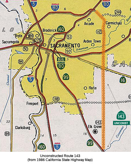
In 1963, this route was defined as "Route 99 near Elk Grove to Route 102 near Antelope."
In 1965, Chapter 1372 deleted the portion from Route 244 to Route 102, making the definition "Route 99 near Elk Grove to Route 244 near Carmichael."
The 1975 act also noted:
"The department and State Transportation Board shall cooperate with the County of Sacramento and the Sacramento Regional Area Planning Commission in the transportation corridor study conducted by the county and the commission on the adopted route for Route 143. Such cooperation by the state shall be limited to furnishing existing data.
The department shall not, prior to July 1, 1976, or such later date as adopted by the California Highway Commission, dispose of any real property acquired for the construction of Route 143 as a freeway from Route 50 to Route 244, except for such real property which, as mutually agreed by the department and the county, is not required for any transportation purpose. If, at such a date, the transportation corridor study indicates the other real property is required for any transportation purpose, the department shall not dispose of the real property prior to January 1, 1977."
Why? According to Concrete Bob on AARoads: In November 1974, the
Sacramento County Board of Supervisors voted 3-2 to reject the funding and
construction of Route 65, Route 143 and Route 244. Construction on Route 143 and Route 244 was slated to begin in 1975. When Adriana Gianturco took
over Caltrans in 1975, she worked with Caltrans and the Legislature to
change the routes/abandon them. Sacramento County was very cooperative
with Caltrans on selling off the rights of way for Route 65, Route 143 and
Route 244, since they rescinded the plans for the freeways in November
1974. One of the County Supervisors who voted down the freeways had a
developer brother-in-law who acquired much of the Route 143 right of way
from Caltrans between Arden Way and American River Drive for a housing
development. Twenty years after the plans for the freeways were yanked,
the Sacramento Bee interviewed the County Supervisors who voted down the
freeways. Two of the three supervisors who voted down the freeways
regretted their decision.
(Source: Concrete Bob on AARoads, 7/22/2019)
Note: The Route 244 definition was changed in 1994, leaving the terminus of this route as not being Route 244, as Route 244 now ends at Auburn Blvd in Carmichael (the difference is about 3/4 mi). Caltrans is treating the new termination as Auburn Blvd in Carmichael, and has designated that portion of former Route 244 as Route 143.
There was a freeway routing adopted for this segment, but it was deleted in 1975. Existing arterials approximating the route are currently utilized, and in 2002 Caltrans recommended removing the route definition from the state highway system (but this never appeared to happen). Approximate roads includes Grant Line Road and Bradshaw Road, but no local roads fit the total description of a traversable highway.
The 2013 Traversable Highways report notes that the Freeway route adoption was rescinded in 1975. The area north of Route 16 has been, or is being, built out in a manner precluding a new highway alignment. Existing arterials (Bradshaw Road, etc.) approximate the route up to the American River, but the arterials serve local traffic. (No local roads fit the description of a traversable highway). District 3 has recommended removal of the route from the State Highway System for some time.
 Pre 1964 Signage History
This route was proposed (routing determined) LRN 247, defined in 1959. It split off Route 244 near Cypress Avenue, continued to near Rita St., and then ran S along Mayhew Road. Route 143 was not defined in the initial set of state signed routes in 1934.
 In 1959, planning started for the Arcade Freeway, which was designed to provide a bypass around
Sacramento for motorists on US 40 and US 50. It would swing in a great
semi-circle across the N area of the city, connecting with US 50 at
Bradshaw Road and ultimately with US 40 at Harbor Blvd in W. Sacramento.
Starting at Bradshaw Road E of Sacramento, the freeway would cross the
American River and bisect the Haggin Bottoms area. It would go beneath
Arden Way E of Fair Oaks Blvd and proceed N about on the line of Walnut
Ave. At approximately Whitney Avenue, it would swing W along Auburn Blvd
and the Roseville Freeway (US 40). The route would be along the N edge of
Del Paso Park and would cross the city of N. Sacramento in the vicinity of
North Avenue. The portion to the W of US 40 would eventually get the
designation of I-880 (for the bypass around Sacramento), and would later
be renumbered I-80. The portion E of US 40 to US 50 was part of planned
Route 143, which was not constructed.
In 1959, planning started for the Arcade Freeway, which was designed to provide a bypass around
Sacramento for motorists on US 40 and US 50. It would swing in a great
semi-circle across the N area of the city, connecting with US 50 at
Bradshaw Road and ultimately with US 40 at Harbor Blvd in W. Sacramento.
Starting at Bradshaw Road E of Sacramento, the freeway would cross the
American River and bisect the Haggin Bottoms area. It would go beneath
Arden Way E of Fair Oaks Blvd and proceed N about on the line of Walnut
Ave. At approximately Whitney Avenue, it would swing W along Auburn Blvd
and the Roseville Freeway (US 40). The route would be along the N edge of
Del Paso Park and would cross the city of N. Sacramento in the vicinity of
North Avenue. The portion to the W of US 40 would eventually get the
designation of I-880 (for the bypass around Sacramento), and would later
be renumbered I-80. The portion E of US 40 to US 50 was part of planned
Route 143, which was not constructed.
(Source: Sacramento Bee, 12/13/1959, via Joel Windmiller, 2/16/2023)
 Status
According to an article in the Sacramento Bee in May 2004, a connection from the Mayhew area to I-80 is proposed along what appears to be the same routing as unbuilt Route 143. The big difference in the May 2004 proposal, which would cost $1.25 billion is that it would have no exits and be built as an underground tunnel from US 50 at Mayhew to I-80 north of Auburn Boulevard. The plan is for a 5.8-mile underground expressway, crossing below the river near the Mayhew drain near Rancho Cordova and making a beeline under Eastern Avenue, linking freeway to freeway. The tunnel is just one of dozens of ideas officials are considering in an effort called "Mobility Strategies for County Corridors". The corridors being studied include Watt Avenue, Greenback Lane, Hazel Avenue, Madison Avenue, Sunrise Boulevard, Howe Avenue, Florin Road and El Grove-Florin Road.
Note that the proposed Capitol Southeast Connector, which would run from I-5 at Grant Line Road to US 50 at the new Silva Valley interchange, approximates the route of unbuilt Route 148 between I-5 and unbuilt Route 143, and unbuilt Route 143 from unbuilt Route 148 to US 50. For more information, see the section on the Capitol Southeast Connector on the page for Route 148.
 Statistics
Overall statistics for Route 143:
 Interstate Submissions
Submitted for inclusion in the interstate system in 1958; not accepted.
 Other WWW Links
 Pre-1964 Legislative Route
In 1933, Chapter 767 added the route from "Arvin Road near Weed Patch to [LRN 57] near Loma Park" to the state highway system. In 1935, this was added to the highway code as LRN 143, with the definition:
In 1959, Chapter 1841 deleted the "near Loma Park" from the definition,
giving "… to [LRN 57] near Loma Park".
This route ran from Route 223 near Weed Patch to Route 178. This is present-day Route 184.
© 1996-2020 Daniel P. Faigin.
Maintained by: Daniel P. Faigin
<webmaster@cahighways.org>.
 Route 142
 Route 144