
 California Highways:
Click here for a key to the symbols used. An explanation of acronyms may be found at the bottom of the page.
 Routing
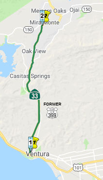 From Route 101 near Ventura to Route 150.
 Post 1964 Signage History
This segment is unchanged from its 1963 definition.
A 1965 planning map shows this as freeway all the way to Ojai. Never upgraded, although a portion from Route 101 N is freeway.
Near Route 145, it appears that Coalinga-Mendota Road and Derrick Blvd is an old routing of Route 33 (US 399).
 Pre 1964 Signage History
The route was conceptualized via an 1890 survey over Pine Mountain south
to Ventura. The 1890 survey was followed by wagon road being
constructed over Pine Mountain to Ventura during 1891. The
communities of Maricopa and Taft organized a "Good Roads Club" in 1911
which led to a political movement to explore upgrading the Pine
Mountain-Ventura Wagon Road to State Highway standards.
(Source: Gribblenation Blog (Tom Fearer), "California State Route 33 and legacy of US Route 399 on the Maricopa-Ventura Highway", August 2021)
The history of this segment (and the next segment) starts in 1913. In 1913, Chapter 610 declared and established a state highway from the city of Bakersfield through a portion of the counties of Kern, San Luis Obispo, Santa Barbara and Ventura to the city of San Buenaventura, to be designated and known as the "Bakersfield, Maricopa and Ventura state highway." This highway was referenced as:
"A certain highway now partly constructed and partly in the course of construction by the several counties through which the same passes and running substantially along the following lines, courses, and distances: Commencing at a point on the proposed California state highway between Bakersfield and Los Angeles [LRN 4] thence following the present county road W 6 mi, then S 12 mi, thence W ½ mi, thence S ¾ mi, thence W 8 mi, thence SW 4 mi, thence W 5 mi to the town limits of the city of Maricopa, thence ... SW 13 miles to the W boundary of Kern County..., thence from a junction at the Kern Cty line with the proposed road as surveyed by Buffington ... for a distance of approx. 5 mi in the county of San Luis Obispo W about 1 mi through the lands of the Kern Cty Land Company and Cuyama Ranch, thence SW-ly 1½ mi, thence E-ly ¾ mi, thence SE-ly about 1 mi through the lands of the Santa Barbara Forest Reserve and of S.B. Miller, said line of proposed road ... following along the E-ly side of the Cuyama River and in the valley of said Cuyama river to the S border of SLO Cty. Thence from a junction point ... being in Sec. 11 T9N R25W SBM and running in a generally SE-ly direction, following the valley of the Cuyama river for a distance of 8.1 mi to a point in the E boundary of Santa Barbara Cty in Sec 17 T8N R24W SBM. Thence from ... the W boundary of Ventura Cty in the valley of the Cuyama River...beginning at a point in Sec 17 T8 R24W SBM approx. 1100 ft S of the N boundary of Sec 17, thence SE-ly along the NE bank of the Cuyama river a distance of 10 mi to a point near the center of Sec 19 T7N R23W on the S-ly bank of the Cuyama river thence E about ¾ mi to a point in the W half of Sec 20 T7N R23W, thence S through the W half of the W half of Sec 20 T7N R23W, and the W half of the W half of Sec 29 T7N R23W on the E side of Boulder Cyn, thence S on the W side of Boulder Cyn through the E half of the SE qtr of Sec 30 and the W half of Sec 32 T7N R23W, thence SW passing the great saddle rock to a point on the summit of Pine Mtn at the quarter corner between Sec 5 and 6, T6N R23W, thence S along the W side of Chorro Chiquito Cyn through Sec 6, 7, 8 and 18 T6N R23W to the valley of the Sespe River, thence crossing the Sespe River and S up the E side of Cherry Ck Cyn through Sec 19, 30, and 31 T6N R23W to the summit of Ortega Hill in Sec 31 T6N R23W, thence from the top of Ortega Hill and following along the Wheeler Ridge passing through the SW corner of Sec 32 T6N R23W, through the NE corner of Sec 1 T5N R24W, through the center of Sec 6 T5N R23W, to the SE corner of Sec 5 T6N R23W, thence S through Sections 8 and 9 T6N R23W, to a point near the ¼ corner on the S side of Sec 8 T5N R23W, to a point in the Matilja Rd near the Matilja Hot Springs in said Sec 29.... thence SE-ly with the Matilja and Meiners Rds ... to the town of Nordhoff ... thence S-ly with the San Antonio Crk Rd, the Nordhoff Rd, and the Ventura Avenue to the N-ly limits of San Buenaventura."
This segment was adopted into the California Highway System in 1915. Within the county, this highway crosses terrain that transitions from mountainous in the southern portion to flat and rolling terrain in the northern portion. Route 33 has been designated as a State Highway Terminal Access Route for larger trucks under the Federal Surface Transportation Act of 1982. Route 33, from its junction with Route 101 to its junction with I-5, is a State Highway Extra Legal Load Route and is included in the National Highway System. Route 33 is also a High Emphasis Interregional Route. The route is designated for explosives, hazardous materials (including rocket fuel), and trucks up to 105 feet in length. On a year-around basis, Route 33 is a significant interregional route for agricultural products, and truck traffic accounts for 40 percent of the Average Annual Daily Traffic.
In 1929, Chapter 541 amended this definition to be:
“…is amended to read as follows: A certain highway now partly constructed by the several counties through which the same passes and by joint highway district number six of the State of California and running substantially along the following lines: Commencing at a point in the Cuyama river valley on the state highway running between Santa Maria, Maricopa, and Bakersfield, and known as [LRN 57] of the state highway system, and running thence SE-ly up the Cuyama river valley to a point in Ventura County; thence S-ly over the Coast Range mountains and through the Santa Barbara national forest to Matilja Hot Springs; thence SE-ly to the city of San Buenaventura. The entire length from San Buenaventura (Ventura) to [LRN 57] of the state highway in the Cuyama valley is hereby declared to be, and is hereby constituted, a state highway... provided that said highway shall not become a state highway ... until said highway shall have been fully completed.”
However, both the 1913 and 1929 statutes were repealed in 1935 by the act that created the highway code. In 1915, Chapter 748 did something similar, with an act for the survey, location, and estimate of cost of a state highway from a point on the present located state highway in Kern County S of Bakersfield to the town of Nordhoff, Ventura County. Again, this was repealed in 1935 by the act that created the highway code. It is possible these early routes were LRN 57, but portions may have shown up in the eventual definition of LRN 138 in 1933.
The Maricopa-Ventura Highway opened on October 22, 1933.
The first mention of US 399 is found in a letter by the Division of
Highways to the AASHO Executive Secretary dated September 6, 1934. US 399
appears as a proposed US Route that would connect US 101 to US 99. US 399
is described as having a proposed length of 131 miles beginning from a
south terminus at US 101 in Ventura along with a north terminus at US 99
in Bakersfield.
(Source: Gribblenation Blog (Tom Fearer), "California State Route 33 and legacy of US Route 399 on the Maricopa-Ventura Highway", August 2021)
In the CHPW announcing the 1934 signage of routes, the route that would become US 399 is shown with a US highway shield, but no specific number, and only runs as far as the junction with LRN 57 (Sign Route 166). That map does not show US highway signage on the route into Bakersfield. "399" is not included on the list of routes in that issue, as the list only covers state sign routes.
Signage of the route as US 399 dates back to around 1935.
Prior to the Ojai Freeway, US 399 (possibly co-signed with Sign Route 150) started at US 101 (Thompson Blvd) and S Ventura Avenue. It continued
N up Ventura Avenue in Ojai, to a junction with Baldwin Avenue, where it
met Sign Route 150 entering from the W. There are some reports* that US 399 may have used Nye Road in Casitas Springs; and Sulphur Mtn Rd, and
abandoned loop and/or Creek Rd, or Old Grade Rd in the Oakview area. It it
did, that usage ended by 1936. Note that there is also a section of Old
Ventura Ave starting at Park Ave in Ojai; that is likely an older routing.
(Source: *Mapmikey: The Virginia Highways Project: US Highways: Histories for Mainline, Suffixed, and Bannered Routes: US 399)
A digression: Sign Route 150 appears to have been an interesting hydra in the area, meaning that there possibly were multiple roads signed as Sign Route 150. The main route—that is, the one that appears to correspond with the state highway map—entered from the Santa Barbara area along Casitas Pass Road. As it neared the lake approaching from the W, it made a horseshoe turn and proceeded to cross the lake along a route that is now underwater, veering N to meet Baldwin Road near the SB Santa Ana Road connection. Sign Route 150 then followed Baldwin Road (and Old Baldwin Road) to meet Ventura Avenue. But the USGS maps also show other routes signed as part of Sign Route 150: Notably, a connection (again, now underwater) to Casitas Vista Road (likely a continuation of Casitas Pass Road) that continued to meet Ventura Road, where it continued S into Ventura as a US 399/Sign Route 150 cosign. The pre-lake Sign Route 150 met another road that is now also underwater, continuing to the NE to about where Santa Ana Road is, where it met today's Route 150 at Baldwin Road. That same USGS map also shows Sign Route 150 running from the Ventura Road/Santa Ana Road junction along Santa Ana Road and Burnham Road to Baldwin Road. The USGS maps are notorious for sometimes showing roads as signed that weren't, but as it was the ACSC that was doing the signing and numbers were less significant to folks, there were often spurs or alternates signed with the number. However, it is clear that Sign Route 150 shared US 399 between Baldwin Road and Ojai Avenue, split back off on its lonesome to the E along Ojai Avenue as solely Sign Route 150.
After the Ojai Freeway was constructed in the early 1950s, the routing in Ventura changed. By 1956, US 399 was using a connector that started near N. Thompson and Main (US 101) near N Garden, which went diagonally to pick up the Ojai Freeway near Park Row Avenue (Note that S. Garden was the US 101 connector between Thompson and W Main before the freeway). That connector was modified with the construction of the Mission Plaza Shopping Center; it now starts off of N Olive below Rex Street, providing accessibility to the Ojai Freeway (now Route 33, nee US 399) from W. Main (which was US 101). After the freeway portion of the Ojai Freeway ends heading N (see the page on Route 33), the road downgrades into Ventura Avenue.
In 1955, planning for the first 4 miles of the Ojai Freeway was nearing
completion. The Ojai Freeway was slated to be a realignment of US 399/LRN 138 off of Main Street and Ventura Avenue in the City of the
Ventura. In 1956, the first 4.1 miles of the Ojai Freeway opened as a
realignment of US 399/LRN 138. The first segment of the Ojai Freeway
began at US 101/LRN 2 on West Main Street near downtown Ventura.
There was a planned interchange to intersect the Ventura Freeway when it
was extended through Ventura. By the end of 1962, the Ventura Freeway
through the City of Ventura was completed (opening during late October
1962). This served to remove US 101/LRN 2 from Main Street/Garden
Street/Thompson Boulevard through the City of Ventura. moving the
connection with the Ojai Freeway/US 399 to an interchange structure. The
original plans were to extend the Ojai Freeway to Route 150, but that
never came to fruition.
(Source: Gribblenation Blog (Tom Fearer), "California State Route 33 and legacy of US Route 399 on the Maricopa-Ventura Highway", August 2021)
In December 1956, US 399 was moved to the first part of the new Ojai
Freeway to open, out of Ventura to the first Ventura Ave overpass. The
freeway started at the Main St/S. Garden (now Business Route 101) and headed NW past
Olive Street and past what are now the ramps for the Main St exit.
(Source: Mapmikey: The Virginia Highways Project: US Highways:
Histories for Mainline, Suffixed, and Bannered Routes: US 399)
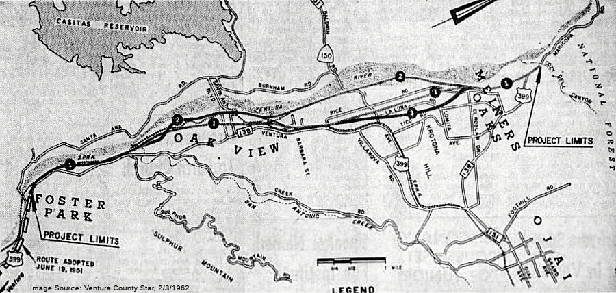 In 1962, it was reported that the the proposals for Ojai Freeway routings through
Foster Park, Oakview, and Meiners Oaks had been narrowed to three basic
locations, with alternate jogs bringing the total to six. The DOH intended
to widen Route 150 from its junction with the new freeway to Ojai's W city
limits, creating a four-lane road at a cost of $200,000. Route 1 would run
E of the river through Oak View and through Mira Monte between La Luna and
Rice Roads to a junction with US 399 at Cozy Dell Canyon. Option 2, the
least expensive, would follow the Ventura River all the way to the same
terminus. Option 3 would be the same as Option 1 through Oak View but
would swing E to a line between La Luna and Tico Roads, then back towards
the river to the terminus. All routes would closely follow the railroad
tracks through Casitas Springs. The Creek Road route that was proposed in
1959 was abandoned. A total of 211 families would be affected by proposed
Option 1, at a cost of 14.9 milllion; Option 2 would affect 112 families
and cost $12.3 million, and Option 3 would affect 190 families and cost
$15.3 million. This proposal never came to fruition, and the Ojai section
of the freeway was deleted from the project.
In 1962, it was reported that the the proposals for Ojai Freeway routings through
Foster Park, Oakview, and Meiners Oaks had been narrowed to three basic
locations, with alternate jogs bringing the total to six. The DOH intended
to widen Route 150 from its junction with the new freeway to Ojai's W city
limits, creating a four-lane road at a cost of $200,000. Route 1 would run
E of the river through Oak View and through Mira Monte between La Luna and
Rice Roads to a junction with US 399 at Cozy Dell Canyon. Option 2, the
least expensive, would follow the Ventura River all the way to the same
terminus. Option 3 would be the same as Option 1 through Oak View but
would swing E to a line between La Luna and Tico Roads, then back towards
the river to the terminus. All routes would closely follow the railroad
tracks through Casitas Springs. The Creek Road route that was proposed in
1959 was abandoned. A total of 211 families would be affected by proposed
Option 1, at a cost of 14.9 milllion; Option 2 would affect 112 families
and cost $12.3 million, and Option 3 would affect 190 families and cost
$15.3 million. This proposal never came to fruition, and the Ojai section
of the freeway was deleted from the project.
(Source: Ventura County Star, 2/3/1962 via email from Will
Poundstone. 1/1/2024)
Between Baldwin Avenue and Ojai Avenue, US 399 was co-signed with Sign Route 150. Sign Route 150 split off at Ojai Ave, and US 399 continued along Maricopa Avenue which turned into Maricopa Highway, now Route 33.
Note: For additional details on the history of this segment, including maps and links to CHPW articles with details, consult the Gribblenation Blogs (Tom Fearer) "California State Route 33; US 101 north to I–5 in Santa Nella" and "California State Route 33 and legacy of US Route 399 on the Maricopa-Ventura Highway".
 Status
In August 2011, the CTC approved $313,000 in SHOPP funding for repairs on Route 33 near Oak View, at San Antonio Creek (VEN 007.58), that will rebuild the slope, roadway and drainage system to correct pre-existing condition as required mitigation at one location.
Route 33 Pavement Preservation Project / Lane Reconfiguration (07-Ven-33 6.3/13.49)
 In December 2025, the CTC approved for future consideration of funding the following
project for which an ND has been completed: SR-33 Pavement
Preservation Project: Route 33 in Ventura County. Perform
multi-asset pavement preservation project in Ventura County on Route 33
from 0.6-miles south of Parkview Drive (PM 6.3) to 0.1-miles north of
Foothill Trail (PM 13.49) in Casitas Springs and Ojai within Ventura
County. Between PM 8.45 to PM 9.12, the project includes reconfiguration
of striping from five lanes to three lanes and the addition of a bike lane
on both sides of the road. (PPNO 07-5619). Other upgrades include
guardrail, curb ramps, and other pedestrian infrastructures. The project
is currently programmed in the 2024 SHOPP. The total programmed amount
which includes Right of Way (Capital), and Construction (Support and
Capital) is $31,781,000. Construction will begin in 2027-28. The scope, as
described for the preferred alternative, is consistent with the project
scope as programmed by the Commission in the 2024 SHOPP. A copy of the ND
has been provided to Commission staff. The project will result in less
than significant impacts to the environment. As a result, an ND was
completed for this project.
In December 2025, the CTC approved for future consideration of funding the following
project for which an ND has been completed: SR-33 Pavement
Preservation Project: Route 33 in Ventura County. Perform
multi-asset pavement preservation project in Ventura County on Route 33
from 0.6-miles south of Parkview Drive (PM 6.3) to 0.1-miles north of
Foothill Trail (PM 13.49) in Casitas Springs and Ojai within Ventura
County. Between PM 8.45 to PM 9.12, the project includes reconfiguration
of striping from five lanes to three lanes and the addition of a bike lane
on both sides of the road. (PPNO 07-5619). Other upgrades include
guardrail, curb ramps, and other pedestrian infrastructures. The project
is currently programmed in the 2024 SHOPP. The total programmed amount
which includes Right of Way (Capital), and Construction (Support and
Capital) is $31,781,000. Construction will begin in 2027-28. The scope, as
described for the preferred alternative, is consistent with the project
scope as programmed by the Commission in the 2024 SHOPP. A copy of the ND
has been provided to Commission staff. The project will result in less
than significant impacts to the environment. As a result, an ND was
completed for this project.
(Source: December 2025 CTC Agenda, Agenda Item 2.2c.(1) #03)
 Naming
Route 33 from Route 101 to Foster Park in Ventura County is named the "Ojai Freeway" (~ VEN 0.000 to VEN 5.995). It was named by its location. The first segment opened in 1956. It was named after the community of Ojai, which was a spelling for the rancheria Aujai is mentioned in mission records. A'hwai is Chumash for "moon."
This segment is also named the "Bakersfield, Maricopa and Ventura Highway" (~ VEN 0.000 to VEN 11.166). It was named by Resolution Chapter 610 in 1913.
 Scenic Route
[SHC 263.3] Entire portion: Route 101 near Ventura to Route l50.
Although this segment is eligible for Scenic Highway status, it has not yet met the criteria to be officially designated as Scenic Highway.
 Classified Landcaped Freeway
The following segments are designated as Classified Landscaped Freeway:
| County | Route | Starting PM | Ending PM |
| Ventura | 33 | 0.00 | 0.47 |
 Freeway
[SHC 253.3] Entire portion; the portion from Route 101 to N of Ventura is constructed to freeway standards. Added to the Freeway and Expressway system in 1959. There were once plans to have a freeway through Ojai.
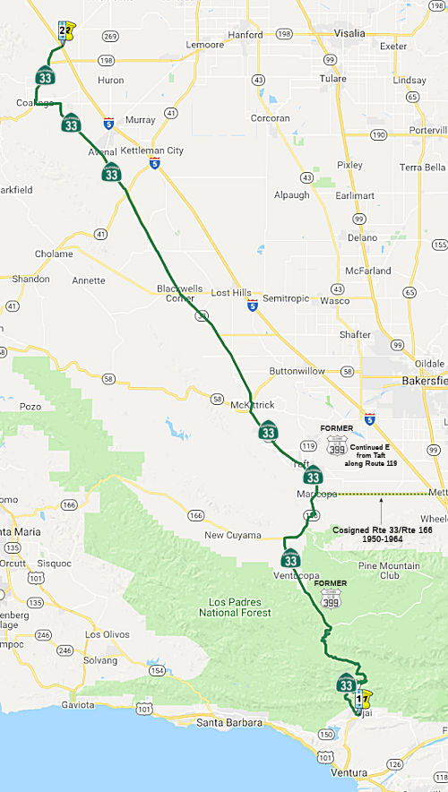 From Route 150 to Route 5 near Oilfields via the vicinity of
Cuyama Valley and Maricopa, and via Coalinga.
From Route 150 to Route 5 near Oilfields via the vicinity of
Cuyama Valley and Maricopa, and via Coalinga.
Post 1964 Signage HistoryThis segment remains as defined in 1963.
Coming into Coalinga along S Lost Hills Road, Route 33 turns onto Jayne Ave which becomes Polk Street. It then angles off onto 5th Street. Upon reaching Elm Street, it continues Northbound cosigned with Route 198. Note that as of May 2015, Google Maps erroneously shows Route 33 continuing along Polk to Elm.
Pre 1964 Signage HistorySee the first segment of this route for the early history prior to 1934.
For the segment between Route 150 and Taft, the route was originally signed as US 399; it was co-signed with Sign Route 166 between near Cuyama and Maricopa. Co-signage with Sign Route 33 started in Maricopa.
In the original signage of route in 1934, Sign Route 33 was signed along the route from Maricopa to Jct. US 50 near Tracy, via Coalinga. The segment between Ventura and Sign Route 166 was indicated to be a US highway, but the number was not shown. That was resolved shortly thereafter, for in 1935, the portion between Sign Route 150 and Taft was resigned as US 399. This particular segment was signed as follows:
 As US 399 between Route 150 (LRN 151) and Sign Route 166 (LRN 57), from 1934-1935 until the 1964 route renumbering. This segment was
part of the 1933 portion of LRN 138. Cosigned as US 399/Sign Route 166 (present-day Route 33/Route 166) between 7 mi N of Ventucopa and Maricopa. This was LRN 57, defined
in 1919. It was first defined as a state highway in 1913 by Legislative
Chapter 610 that declared a State Highway between Ventura and
Bakersfield. It was further specified in 1915 by Legislative Chapter 748
as "from a point on the present located state highway in Kern County S
[LRN 4, US 99] of Bakersfield to the town of Nordhoff (now Ojai),
Ventura County." LRN 57 would be extended by the 1919 Third State
Highway Bond Act to run from Freemans Junction near Santa Maria to
Bakersfield, becoming the basis for Sign Route 166. Cosigned as US 399/Sign Route 33 between Maricopa and Taft. This
was part of the portion of LRN 138 defined in 1933. By the 1950 state
highway map, the start of signed Route 33 was moved to US 99 6 mi N of
Wheeler Ridge (near the current I-5/Route 99 junction) and the segment
from Route 99 to Maricopa was cosigned as Sign Route 33/Sign Route 166
(it was resigned in 1964 as Route 166). That latter routing was LRN 57
(also defined in 1919). The signage of Sign Route 33 N from Maricopa
dates to the initial state signage of routes in 1934.
As US 399 between Route 150 (LRN 151) and Sign Route 166 (LRN 57), from 1934-1935 until the 1964 route renumbering. This segment was
part of the 1933 portion of LRN 138. Cosigned as US 399/Sign Route 166 (present-day Route 33/Route 166) between 7 mi N of Ventucopa and Maricopa. This was LRN 57, defined
in 1919. It was first defined as a state highway in 1913 by Legislative
Chapter 610 that declared a State Highway between Ventura and
Bakersfield. It was further specified in 1915 by Legislative Chapter 748
as "from a point on the present located state highway in Kern County S
[LRN 4, US 99] of Bakersfield to the town of Nordhoff (now Ojai),
Ventura County." LRN 57 would be extended by the 1919 Third State
Highway Bond Act to run from Freemans Junction near Santa Maria to
Bakersfield, becoming the basis for Sign Route 166. Cosigned as US 399/Sign Route 33 between Maricopa and Taft. This
was part of the portion of LRN 138 defined in 1933. By the 1950 state
highway map, the start of signed Route 33 was moved to US 99 6 mi N of
Wheeler Ridge (near the current I-5/Route 99 junction) and the segment
from Route 99 to Maricopa was cosigned as Sign Route 33/Sign Route 166
(it was resigned in 1964 as Route 166). That latter routing was LRN 57
(also defined in 1919). The signage of Sign Route 33 N from Maricopa
dates to the initial state signage of routes in 1934. Near Ojala (near Matilijia Lake), around 1949, US 399 was removed from
the lower part of the Ojala Quarry driveway; and around 1953, US 399 was
removed from the driveway to 15275 Hwy 33 south of Ojala, which no longer
connects back up with Route 33.
(Source: Mapmikey: The Virginia Highways Project: US Highways:
Histories for Mainline, Suffixed, and Bannered Routes: US 399)
By 1931, the three Matilija Tunnels on LRN 138 in Wheeler Gorge had been
completed. Construction continued in 1934 along LRN 138 from Ventura
to LRN 57 in Cuyama Valley, along an alignment following; Ojai Valley,
Wheeler Gorge, the Sespe Gorge and Pine Mountain.The Maricopa-Ventura
Highway opened on October 22, 1933. The route was conceptualized via
an 1890 survey over Pine Mountain south to Ventura. The 1890 survey
was followed by wagon road being constructed over Pine Mountain to Ventura
during 1891. The communities of Maricopa and Taft organized a "Good
Roads Club" in 1911 which led to a political movement to explore upgrading
the Pine Mountain-Ventura Wagon Road to State Highway standards. By 1950,
Route 33 had been extended from Maricopa via Route 166/LRN 57 to US 99/LRN 4.
(Source: Gribblenation Blog (Tom Fearer), "California State Route 33 and legacy of US Route 399 on the Maricopa-Ventura Highway", August 2021)
Maricopa Highway continued as US 399 (today's Route 33) to a point E of Cuyama Ranch, where it met Sign Route 166 and continued co-signed to the NE (this is today a Route 33/Route 166 cosign, legislatively Route 33) into Maricopa. In Maricopa, Sign Route 166 continued to the E along Maricopa Highway, while US 399 continued (potentially cosigned with Sign Route 33) N along California St. This later became today's West Side Highway; it is unclear the former name of the road.
In the period between 1934 and 1938 between the outskirts of Maricopa and
Taft, US 399 originally used Petroleum Club Road. This corridor was
constructed as a frontage road of the Sunset Railroad and would be the
site of the Lakeview Gusher in 1910. In January 1938, US 399 was moved to
the current West Side Highway routing. Within Taft, before 1935, US 399
used Wood St. to abandoned route north that is now a parking lot adjacent
to West Kern Oil Museum, to today's Taft Bypass, to Center St. or Main St,
to 1st St to Kern St.to 6th St/Harrison St. In May
1935, US 399 was given a more direct routing through Taft using West Side
Hwy, Kern St, and 6th St/Harrison St.
(Source: Mapmikey: The Virginia Highways Project: US Highways:
Histories for Mainline, Suffixed, and Bannered Routes: US 399; Gribblenation Blog, "Petroleum Club Road (former California State Route 33 and US Route 399 past the Lakeview Gusher)", 5/6/2026)
Within Taft, US 399 originally ran along 6th Street/Harrison
Street, with Sign Route 33 splitting off at San Emigdio Street. Later, the
route was adjusted to have Sign Route 33 continue on Kern Street. This
happened in 1935, when Sign Route 33 (LRN 138) was realigned through Taft.
The then new alignment was constructed onto two extensions of Kern Street
on both sides of downtown. The multiplex of US 399 and Sign Route 33 was
realigned to meet at Kern Street and 6th Street.
(Source: Gribblenation Blog, "Petroleum Club Road (former California State Route 33 and US Route 399 past the Lakeview Gusher)", 5/6/2026)
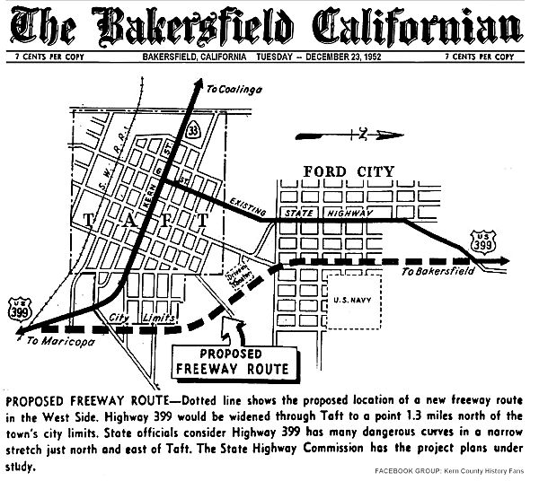 In 1952, a freeway alignment was adopted for US 399 (now Route 33 and Route 119)
through Taft. The plan was to widen US 399 through Taft to a point 1.3mi N
of the town's city limits. Project plans were under study The bypass was
constructed in 1956. Subsequent discussion on the Facebook post where this
map was posted indicated that the final adopted routing differed slightly
from the routing shown. Specifically, the proposed route seems to show the
new routing running along Monroe St, whereas the actually routing runs
about 6-7 blocks to the E, running straight to the N and curving back
after passing what is shown as the US Navy land in the diagram. In any
case, by 1956, US 399 was using the alignment used by today's Route 119:
veering off the West Side Highway/Kern Street at Taft Highway. It merges
with the old allignment, Harrison St. just N of the town of Taft in a
community called Ford City. Note that Harrison Street continues NE after
the first merge to meet Taft Highway again, at a point E of Elk Hills
Road; that portion of Harrison Street was the original US 399 prior to the
Taft Highway realignment.
In 1952, a freeway alignment was adopted for US 399 (now Route 33 and Route 119)
through Taft. The plan was to widen US 399 through Taft to a point 1.3mi N
of the town's city limits. Project plans were under study The bypass was
constructed in 1956. Subsequent discussion on the Facebook post where this
map was posted indicated that the final adopted routing differed slightly
from the routing shown. Specifically, the proposed route seems to show the
new routing running along Monroe St, whereas the actually routing runs
about 6-7 blocks to the E, running straight to the N and curving back
after passing what is shown as the US Navy land in the diagram. In any
case, by 1956, US 399 was using the alignment used by today's Route 119:
veering off the West Side Highway/Kern Street at Taft Highway. It merges
with the old allignment, Harrison St. just N of the town of Taft in a
community called Ford City. Note that Harrison Street continues NE after
the first merge to meet Taft Highway again, at a point E of Elk Hills
Road; that portion of Harrison Street was the original US 399 prior to the
Taft Highway realignment.
(Source: Art Moore on FB, 12/22/2022, sharing map from the Bakersfield Californian, 12/23/1952)
US 399 continued E along Taft Highway. Near the N Coles Oil Field, US 399 originally veered off along today's Golf Course Road and Tupman Road (now Golf Course Road, until it crosses Taft Highway and becomes Tupman again). That loop was cutoff by the construction of Taft Highway. US 399 continued along Taft Highway into Greenfield, where it met US 99.
Starting in Taft, Sign Route 33 continued N by its lonesome. This signage also goes back to the original signage of routes in 1934. The segment N of Taft was signed as follows:
Note: For additional details on the history of this segment, including maps and links to CHPW articles with details, consult the Gribblenation Blogs (Tom Fearer) "California State Route 33; US 101 north to I–5 in Santa Nella" and "California State Route 33 and legacy of US Route 399 on the Maricopa-Ventura Highway".
Much of the push for the route along the west side of the San Joaquin
Valley came from the large "agribusinesses" that dominate the west side of
the San Joaquin Valley: oil, cotton, and cattle along the southern
reaches, and fruits/vegetables from Mendota north (Mendota to Los Banos is
the center of CA's melon-growing region). After WWII, Sign Route 33
multiplexed with Sign Route 166 from Taft to US 99 near Wheeler Ridge; the
rationale behind that was to position Sign Route 33 as an alternate to US 99, particularly when the latter route was socked in with "tule fog" in
winter months.
(Source: Sparker on AAroads, 7/25/2018)
Route 33 had many segments that were originally signed over local
roadways, primarily in the stretch from Route 198/LRN 10 near Coalinga to
Route 180/LRN 41 in Mendota. 1955 Legislative Chapter 1912 extended LRN 138 north from Coalinga to Mendota, closing the gap in the locally
maintained segment of Route 33.
(Source: Gribblenation Blog (Tom Fearer), "California State Route 33 and legacy of US Route 399 on the Maricopa-Ventura Highway", August 2021)
Based on a 1948 map, south of Reef Station (the Route 41/Route 33
junction), Sign Route 33's historic alignment diverted from the current
one to serve the settlement of Devil's Den. The roads Route 33 used
back then are now Barker Road and Twisselman Road. The current alignment
of Route 33 between Barker and Twisselman roads was first shown on the
1961 state highway map. The 1948 map also shows that Route 33 near
Coalinga originally used roads closer to the Coast Range fall line than
the longstanding right-angle route east of town via Jayne Ave—and
definitely shown as much "twistier" than the later alignment.
(Source: Chris Sampang and Scott Parker on AARoads, "Re: CA 33", 11/26/2020)
—————
1: Note that Sparker on AAroads appears to disagree with this, writing in one post: "Both of those were commissioned prior to WWII; the section between Coalinga
and Mendota (using Derrick Ave.) remained a county road until about
1957, when it was brought into the system as an extension of LRN 138 and
signed as Route 33."
The original alignment of Route 33/LRN 138 south of Coalinga utilized
Merced Avenue and Lost Hills Road. Route 33/LRN 138 shifted onto
Jayne Avenue by 1963, suggesting a maintenance swap occurred during 1962.
The original alignment of Route 33 north of Coalinga followed
Coalinga-Mendota Road north to Derrick Avenue. Bridge stamps on I-5
between Exit 337 at Route 145 north to Exit 349 show the structures were
completed by 1968. When I-5 was completed between Exit 337 and Exit
349, Route 33 was realigned onto a multiplex. This occured between 1970
and 1975.
(Source: Gribblenation Blog (Tom Fearer), "California State Route 33 and legacy of US Route 399 on the Maricopa-Ventura Highway", August 2021)
StatusIn February 2019, it was reported that the CTC allocated $850,000 for a
bridge project on Route 33 in Ventura County: the overall $2.5 million
bridge project will paint the steel portion of the North Fork Matilija
Creek Bridge (~ VEN 015.52) on Route 33 for preventative maintenance and
to extend the life of the bridge.
(Source: SCV News, 2/6/2019)
Matilija Tunnel Rehabilitation (07-Ven-33 18.2/19.0)
In October 2024, the CTC approved amending the
following SB1 project into the 2024 SHOPP: 07-Ven-33 18.2/19.0. PPNO
07-6360; ProjID 0724000151; EA 0Y220 . Route 33 Near Ojai, at South
Matilija Tunnel № 52-0068 (PM 18.33), Middle Matilija Tunnel №
52-0070 (PM 18.81), and North Matilija Tunnel № 52-0072 (PM 18.85).
Place reinforced structural concrete liner over the existing steel panels,
replace damaged ribs throughout the tunnels, and repair delaminated
concrete at the tunnel entrance. PA&ED: 2/15/2024. R/W: 5/12/2025.
RTL: 5/30/2025 . BC: 1/17/2026. Allocation ($ × $1000): PA&ED $0;
PS&E $950; R/W Sup $10; Con Sup $1,505; R/W Cap $0; Const Cap: $2,675;
TOTAL $5,140. Concurrent COS allocation under Resolution FP-24-28; October
2024.
(Source: October 2024 CTC Agenda, Agenda Item 2.1a.(1b) #4)
In October 2024, the CTC approved the following SHOPP
SB1 project preconstruction-phase allocation: $960,000. 07-Ven-33
18.2/19.0. PPNO 07-6360; ProjID 0724000151; EA 0Y220. Route 33 Near Ojai,
at South Matilija Tunnel № 52-0068 (PM 18.33), Middle Matilija
Tunnel № 52-0070 (PM 18.81), and North Matilija Tunnel №
52-0072 (PM 18.85). Outcome/Outputs: Place reinforced structural
concrete liner over the existing steel panels, replace damaged ribs
throughout the tunnels, and repair delaminated concrete at the tunnel
entrance. Concurrent Amendment under SHOPP Amendment 24H-005; October
2024. Allocation (Programmed, if different): PS&E
$950,000; RW Sup $10,000.
(Source: October 2024 CTC Agenda, Agenda Item 2.5b.(2b) #16)
In October 2025, the CTC approved the following
construction phase allocation for a 2024 SHOPP project: $4,427,000.
07-Ven-33 18.20/19.00. PPNO 07-6360; ProjID 0724000151; EA 0Y220. Route 33
Near Ojai, at South Matilija Tunnel № 52-0068 (PM 18.33), Middle
Matilija Tunnel № 52-0070 (PM 18.81), and North Matilija Tunnel
№ 52-0072 (PM 18.85). Place reinforced structural concrete
liner over the existing steel panels, replace damaged ribs throughout the
tunnels, and repair delaminated concrete at the tunnel entrance. CEQA -
CE, 08/23/2024; Re-validation 06/11/2025. NEPA - CE, 08/23/2024;
Re-validation 06/11/2025. Pre-Construction Phase: Budgeted (Actual,
if different): PA&ED $0 ($0); PS&E
$1,250,000 ($673,233); R/W Sup $10,000 ($2,349).
Construction Phase - Programmed (Allocation, if different):
CON ENG $1,505,000; CONST $2,675,000.
(Source: October 2025 CTC Agenda, Agenda Item 2.5b.(1) #17)
VEN-33 Road Safety Enhancement Project (07-Ven-33, PM 18.88/19.04)
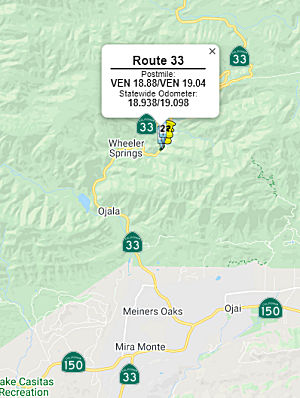 The 2020 SHOPP, approved in May 2020, included the
following Collision Reduction item of interest (carried over from the 2018
SHOPP): 07-Ventura-33 PM 18.9/19.1 PPNO 5145 Proj ID 0716000257 EA 33230.
Route 33 near Ojai, north of North Fork Matilija Creek Bridge No. 52-450.
Widen the roadway by 4 feet, upgrade rock block barrier, and place High
Friction Surface Treatment (HFST). Programmed in FY21-22, with
construction scheduled to start in July 2022. Total project cost is
$6,854K, with $3,144K being capital (const and right of way) and $3,710K
being support (engineering, environmental, etc.).
The 2020 SHOPP, approved in May 2020, included the
following Collision Reduction item of interest (carried over from the 2018
SHOPP): 07-Ventura-33 PM 18.9/19.1 PPNO 5145 Proj ID 0716000257 EA 33230.
Route 33 near Ojai, north of North Fork Matilija Creek Bridge No. 52-450.
Widen the roadway by 4 feet, upgrade rock block barrier, and place High
Friction Surface Treatment (HFST). Programmed in FY21-22, with
construction scheduled to start in July 2022. Total project cost is
$6,854K, with $3,144K being capital (const and right of way) and $3,710K
being support (engineering, environmental, etc.).
(Source: 2020 Approved SHOPP a/o May 2020)
In August 2021, the CTC approved the following project
for future consideration of funding: 07-Ven-33, PM 18.88/19.04. VEN-33
Road Safety Enhancement Project. Reduce collision severity on Route 33 by widening the roadway and upgrading rock barriers, among other
improvements, in Ventura County. (MND) (PPNO 5145) (SHOPP). This project
is located on Route 33 from post mile 18.88 to 19.04, in Ventura County.
The Department proposes to enhance safety on a narrow-curved roadway on
the Route 33 from post mile 18.88 to 19.04 in Ventura County. The project
scope includes widening the roadway, replacing the rock barrier,
installing drainage ditch, and applying high friction surface treatment.
This project is currently programmed in the 2020 SHOPP for a total of
$8,005,000, which includes Construction (capital and support) and Right of
Way (support). Construction is estimated to begin in 2022. The scope, as
described for the preferred alternative, is consistent with the project
scope as programmed by the Commission in the 2020 SHOPP. A copy of the MND
has been provided to Commission staff. The project will result in
less than significant impacts to the environment after mitigation.
The following resource areas may be impacted by the project: biological
resources. Avoidance and minimization measures will reduce any
potential effects on the environment. These measures include, but are not
limited to, replantation of riparian habitat species onsite and in a
biological study area outside of the project impact area within North Fork
Matilija Creek. As a result, an MND was completed for this project.
(Source: August 2021 CTC Agenda, Agenda Item
2.2c.(1))
Also in August 2021, the CTC approved the following
preconstruction allocation: 07-Ven-33 18.9/19.1. PPNO 07-5145; ProjID
0716000257; EA 33230. Route 33 Near Ojai, north of North Fork Matilija
Creek Bridge No. 52-450. Widen the roadway by four feet, upgrade rock
block barrier, and place High Friction Surface Treatment (HFST).
(Concurrent consideration of funding under Resolution E-21-81; August
2021.) (Four month time extension for PS&E approved under Waiver
21-59; June 2021.) Allocation: PS&E $1,460,000 ($1,558,000 programmed)
(21-22)
(Source: August 2021 CTC Agenda, Agenda Item
2.5b.(2a) #14)
In August 2024, the CTC amended the following project
into the SHOPP: 07-Ven-33 18.9/19.1. PPNO 07-5145; ProjID 0716000257; EA
33230. Route 33 Near Ojai, from 0.2 mile to 0.4 mile north of North Fork
Matilija Creek Bridge. Widen the roadway, replace existing rock
block wall with a concrete barrier, and upgrade drainage system to improve
safety. Concurrent COS allocation under Resolution FP-24-09; August
2024. Allocation ($ × $1000): PA&ED $0; PS&E $485; R/W Sup
$0; Con Sup $1,830; R/W Cap $10; Const Cap: $6,450; TOTAL $8,775.
(Source: August 2024 CTC Minutes, Agenda Item 2.1a.(1a) #4)
In August 2024, the CTC authorized the following
pre-construction-phase allocation for the following SHOPP project:
$485,000. 07-Ven-33 18.9/19.1. PPNO 07-5145; ProjID 0716000257; EA 33230.
Route 33 Near Ojai, from 0.2 mile to 0.4 mile north of North Fork Matilija
Creek Bridge. Outcome/Outputs: Widen the roadway, replace
existing rock block wall with a concrete barrier, and upgrade drainage
system to improve safety. Future consideration of funding approved
under Resolution E-21-81; August 2021. Concurrent Amendment under SHOPP
Amendment 24H-004; August 2024. Allocation (Programmed, if
different): PS&E $485,000.
(Source: August 2024 CTC Agenda, Agenda Item 2.5b.(2a) #19)
In October 2024, the CTC approved the following SHOPP
construction-phase allocation: $8,306,000. 07-Ven-33 18.9/19.1. PPNO
07-5145; ProjID 0716000257; EA 33230. Route 33 Near Ojai, from 0.2 mile to
0.4 mile north of North Fork Matilija Creek Bridge. Outcome/Outputs:
Widen the roadway, replace existing rock block wall with a concrete
barrier, and install additional warning signs to improve safety.
This project will reduce the number and severity of collisions. CEQA -
MND, 5/12/2021; Re-validation 6/20/2024 NEPA - FONSI, 5/12/2021;
Re-validation 6/20/2024. Future consideration of funding approved under
Resolution E-21-81; August 2021 Allocation CON ENG $1,830,000; CONST
$6,450,000.
(Source: October 2024 CTC Agenda, Agenda Item 2.5b.(1) #18)
![[Rte 46 Interchange Realignment]](maps/033-rt46-realign.jpg) In April 2007, the CTC
considered a routing change for this route where it intersects Route 46 (~
KER 61.02). The proposed route adoption for this segment of Route 33 would
improve the safety and the operations at the Route 46 junction. Under the
change, Route 33 will be realigned to provide a 90-degree approach to
Route 46. The junction will be constructed with exclusive right and left
turn lanes, and storage for left turn movements. In addition, Route 46
will be rehabilitated to meet current design standards from the San Luis
Obispo County line to 0.8 mile west of Lost Hills Road. The current
alignments intersects Route 46 at an angle.
In April 2007, the CTC
considered a routing change for this route where it intersects Route 46 (~
KER 61.02). The proposed route adoption for this segment of Route 33 would
improve the safety and the operations at the Route 46 junction. Under the
change, Route 33 will be realigned to provide a 90-degree approach to
Route 46. The junction will be constructed with exclusive right and left
turn lanes, and storage for left turn movements. In addition, Route 46
will be rehabilitated to meet current design standards from the San Luis
Obispo County line to 0.8 mile west of Lost Hills Road. The current
alignments intersects Route 46 at an angle.
In October 2013, the CTC considered for future approval of funding a project in Fresno County that will replace the existing Jacalitos Creek Bridge (Bridge 42-0441, FRE 011.00) on Route 33 near the city of Coalinga. The project is programmed in the 2012 State Highway Operation and Protection Program. The total estimated cost is $10,739,000 for capital and support. Construction is estimated to begin in Fiscal Year 2014-15. The scope, as described for the preferred alternative, is consistent with the project scope programmed by the Commission in the 2012 State Highway Operation and Protection Program.
In March 2012, the CTC authorized relinquishment of right of way in the county of Kern on Route 33 from 0.4 mile southeasterly of Route 46 to Route 46 (~KER 60.62 to KER 61.02), consisting of superseded highway right of way and collateral facilities. They also authorized vacation of right of way in the county of Kern along Route 33 between 0.5 mile southeasterly (~ KER 60.52 to KER 61.52) and 0.5 mile northwesterly of Route 46, consisting of superseded highway right of way no longer needed for State highway purposes.
Naming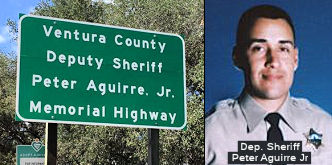 The portion of Route 33 in the County of Ventura from West Ojai Avenue at VEN
11.21 to Fairview Road at VEN 12.8 is named the "Ventura County Deputy
Sheriff Peter Aguirre, Jr. Memorial Highway". Deputy Sheriff Peter
Aguirre, Jr. studied for six years in college and planned to become a
schoolteacher, but shortly before his death, switched to law enforcement
studies. He served with the Ventura County Sheriff’s Department for
two years and ten months. On July 17, 1996, when Deputy Sheriff Peter
Aguirre, Jr. was 26 years old, he responded to a domestic violence call at
a home in the Ojai Valley community of Meiners Oaks in Ventura County. As
Peter was approaching the home, he was ambushed and shot, and died as a
result of the injury. Named by Assembly Concurrent Resolution (ACR) 142,
Res. Chapter 83, Statutes of 2016 on July 11, 2016.
The portion of Route 33 in the County of Ventura from West Ojai Avenue at VEN
11.21 to Fairview Road at VEN 12.8 is named the "Ventura County Deputy
Sheriff Peter Aguirre, Jr. Memorial Highway". Deputy Sheriff Peter
Aguirre, Jr. studied for six years in college and planned to become a
schoolteacher, but shortly before his death, switched to law enforcement
studies. He served with the Ventura County Sheriff’s Department for
two years and ten months. On July 17, 1996, when Deputy Sheriff Peter
Aguirre, Jr. was 26 years old, he responded to a domestic violence call at
a home in the Ojai Valley community of Meiners Oaks in Ventura County. As
Peter was approaching the home, he was ambushed and shot, and died as a
result of the injury. Named by Assembly Concurrent Resolution (ACR) 142,
Res. Chapter 83, Statutes of 2016 on July 11, 2016.
(Image source: Vent. County Sheriff's Facebook Page, Vent. County Sheriff's Office Memorial Page)
The portion of this segment between Route 150 and Route 119 (~ VEN 11.21 to KER 17.985) is named the "Bakersfield, Maricopa and Ventura Highway". It was named by Chapter 610 in 1913.
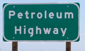 The portion of Route 33 in Kern County between
Route 166 and Route 46 (~KER 11.898 to KER 61.02) is named the Petroleum
Highway. It was named in recognition of the petroleum industry,
which has made an important economic contribution to Kern County and other
parts of the state. The heart of oil country in Kern County is in the
western part of the county adjacent to Route 33, where oil has been
produced for more than 100 years. In fact, this region of Kern County
produces 50 percent of California's oil production; and the largest gas
field in the west, Elk Hills, is within sight of Route 33. Travelers on
Route 33 can visit the only oil boomtowns in California and the West Kern
Oil Museum in Taft. Named by Assembly Concurrent Resolution 185, July 16,
2004, Chapter 128.
The portion of Route 33 in Kern County between
Route 166 and Route 46 (~KER 11.898 to KER 61.02) is named the Petroleum
Highway. It was named in recognition of the petroleum industry,
which has made an important economic contribution to Kern County and other
parts of the state. The heart of oil country in Kern County is in the
western part of the county adjacent to Route 33, where oil has been
produced for more than 100 years. In fact, this region of Kern County
produces 50 percent of California's oil production; and the largest gas
field in the west, Elk Hills, is within sight of Route 33. Travelers on
Route 33 can visit the only oil boomtowns in California and the West Kern
Oil Museum in Taft. Named by Assembly Concurrent Resolution 185, July 16,
2004, Chapter 128.
(Image source: Bertrand Celce)
The portion of this route N of Route 166 (~KER 11.898) has historically been called El Camino Viejo. More information on El Camino Viejo, which was an interior route used to avoid the more patrolled coast El Camino Real, may be found on the Wikipedia page (although it doesn't give a detailed map). It looks like this historical reference relates to the proximity to the former Bitter Creek and Lake Buena Vista, which used to run near Maricopa.
 Named Structures
Tunnels 52-068, 52-070, and 52-072 in Ventura county, built in 1931, are unofficially named the "Matilija Tunnels" (~ VEN 015.52 to VEN 18.84).
Scenic Route[SHC 263.3] From Route 150 to Route 166 in Cuyama Valley; and from Route 198 near Coalinga to Route 198 near Oilfields.
Eligible for Scenic Highway status per [SHC 263.2]. The following portions have been officially designated as Scenic Highway and are signed:
Freeway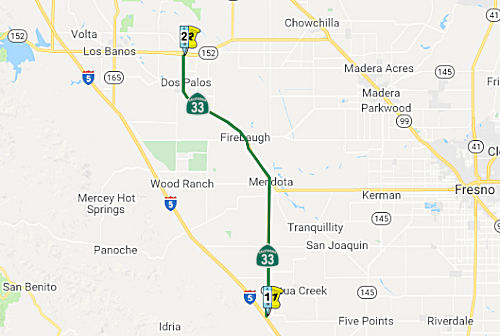 From Route 5 to Route 152 via the vicinity of Mendota.
Post 1964 Signage HistoryThis segment remains as defined in 1963.
The portion between Route 5 near Oilfields to 12 mi N (i.e., the break between segments) is cosigned I-5/Route 33.
Pre 1964 Signage HistoryIn 1934, Route 33 was signed along the route from Maricopa to Jct. US 50 near Tracy, via Coalinga. This particular segment was signed as follows:
Prior to the 1955 extension, it appears that S Derrick Ave and
Coalinga-Mendota Road were county roads, but were still signed as Route 33. The old Division of Highways was a bit more flexible about signage
than the current Caltrans; a few county roads, including Derrick Avenue,
got signage pre-state-adoption or maintenance; they tended to be receptive
to state and/or local power brokers regarding this practice. According to
a number of accounts, Getty Oil, which had several small fields in and
around Coalinga but was not satisfied with the frequency of service
Southern Pacific was supplying to that area to move loaded tank cars out
from the loading areas outside of town along Route 198 and wanted to
supplement it with tanker trucks, somewhere around 1945 pressed the state
senator representing much of western Kings and Fresno Counties to ask the
Division of Highways to deploy a state highway north from Coalinga to
Merced, where there was an oil loading facility along competing Santa Fe;
they wanted a facility on which to "convoy" several tank trucks at a time
to make it worthwhile for Santa Fe to handle the loads. The Division
already had much of the pathway covered by LRN 41/Route 33 from Mendota to
Dos Palos Wye, LRN 32/Route 152 east for several miles from there, and LRN 123 the rest of the way into Merced (it wasn't signed as Route 59 until at
least 1960). But the Division was reluctant to take on the most direct
route from Coalinga to Mendota, Derrick Road (named as such because it
passed through Getty oilfields in the hills north of Coalinga, featuring
numerous oil derricks), primarily because the oiled-earth facility was a
county maintenance nightmare due to consistent rutting by the small but
stout oilfield trucks with exceptionally heavy per-axle loading. But
politics prevailed, and the Division worked out deals with Fresno County
to split the maintenance costs -- and the road was signed as Route 33 by
mid-1946. Eventually an asphalt overlay was done on the road, and the
state assumed maintenance and ownership in 1957 [Ed - perhaps
authorized by the 1955 extension].
(Source: Sparker on AAroads, 7/25/2018; Sparkeron
AAroads, 7/25/2018)
Within the City of Firebaugh, the original alignment of Route 33/LRN 41
Route 33 headed southbound passed through Firebaugh via N Street, 8th
Street, O Street, 12th Street, Nees Avenue and Washoe Avenue.
Route 33 would have entered Firebaugh via 12th Street and
traversed the downtown area on O Street and 8th Street. In
1939, Route 33/LRN 41 in Firebaugh was straightened and realigned onto N
Street as a corporative project between the Division of Highways and
Southern Pacific Railroad, borne out of interests in eliminating two
railroad crossings. The realignment began one mile north of the
community extending one and half miles south of the community, and
included two new canal bridges.
(Source: Gribblenation Blog (Tom Fearer), "California State Route 33 and legacy of US Route 399 on the Maricopa-Ventura Highway", August 2021; “The original alignment of California State Route 33 in Firebaugh”,
May 2022)
Within Dos Palos, Route 33 (LRN 41, defined in 1933) originally entered
via Brannon Avenue and Valeria Avenue from the Fresno County Line.
It then passed through downtown Dos Palos via Center Avenue and Blossom
Street towards Elgin Avenue. North of Dos Palos at the Dos Palos
Y, the routing joined Route 152 via what is now Azusa Avenue. In
1965, a realignment of Route 33 was announced that would originate at
Laguna Canal in Fresno County and connect with Elgin Avenue in Dos
Palos. The realignment included widening the highway on Elgin Avenue
to four-lanes. Cost for the realignment in Dos Palos was shared by
the State, Fresno County and city of Dos Palos. By 1967, Route 152/Route 33 had been converted to a four-lane expressway from Los Banos
11 miles east to Dos Palos Y, including a bypass of Dos Palos Y and a new
interchange from which Route 33 would depart towards Dos Palos.
Today, Modern Route 33 passes through Dos Palos on a northward course via
Elgin Avenue towards Route 152 at Dos Palos Y.
(Source: Gribblenation Blog (Tom Fearer), "The original alignment of California State Route 33 in Dos Palos", June 2022)
Note: Tom Fearer has some excellent historical information on this segment in his Gribblenation Blog entry: California State Route 33 and legacy of US Route 399 on the Maricopa-Ventura Highway.
NamingThis segment has historically been called El Camino Viejo.
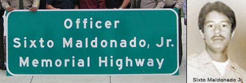 The portion of Route 33
between Bullard Avenue and Douglas Avenue in the City of Firebaugh (~ FRE
R67.31 to FRE 72.813) in Fresno County is named the "Officer Sixto
Maldonado, Jr., Memorial Highway". Named in memory of Sixto
Maldonado, Jr., born on April 9, 1952, in Fresno. He attended Arthur E.
Mills Elementary School and Riverview Junior High School in Firebaugh,
followed by Dos Palos High School. Mr. Maldonado was a member of the
newly-formed Firebaugh Youth Group, served as its president for a number
of years while in high school, and was a role model student who was highly
respected in his community. He worked in the fields as a farm laborer at a
very young age to help his parents provide for their family. Mr. Maldonado
worked in a variety of different jobs to help offset costs of his extended
education, and in 1972, enrolled and attended 4 C's Business College with
a major in business administration. He started his law enforcement career
as a Firebaugh Police Department Reserve/Dispatcher in 1973, and was also
an emergency medical technician for the City of Firebaugh where he drove
and assisted on ambulance runs. Officer Maldonado was tragically slain in
the line of duty as a Firebaugh police officer on August 19, 1975, at the
age of 23, leaving behind his wife and son; and a legacy of his
distinguished service to law enforcement, with three brothers and a nephew
following in his footsteps by becoming peace officers for the County of
Fresno. Named by Assembly Concurrent Resolution (ACR) 128, Resolution
Chapter 75, on 7/3/2008.
The portion of Route 33
between Bullard Avenue and Douglas Avenue in the City of Firebaugh (~ FRE
R67.31 to FRE 72.813) in Fresno County is named the "Officer Sixto
Maldonado, Jr., Memorial Highway". Named in memory of Sixto
Maldonado, Jr., born on April 9, 1952, in Fresno. He attended Arthur E.
Mills Elementary School and Riverview Junior High School in Firebaugh,
followed by Dos Palos High School. Mr. Maldonado was a member of the
newly-formed Firebaugh Youth Group, served as its president for a number
of years while in high school, and was a role model student who was highly
respected in his community. He worked in the fields as a farm laborer at a
very young age to help his parents provide for their family. Mr. Maldonado
worked in a variety of different jobs to help offset costs of his extended
education, and in 1972, enrolled and attended 4 C's Business College with
a major in business administration. He started his law enforcement career
as a Firebaugh Police Department Reserve/Dispatcher in 1973, and was also
an emergency medical technician for the City of Firebaugh where he drove
and assisted on ambulance runs. Officer Maldonado was tragically slain in
the line of duty as a Firebaugh police officer on August 19, 1975, at the
age of 23, leaving behind his wife and son; and a legacy of his
distinguished service to law enforcement, with three brothers and a nephew
following in his footsteps by becoming peace officers for the County of
Fresno. Named by Assembly Concurrent Resolution (ACR) 128, Resolution
Chapter 75, on 7/3/2008.
(Image source: Find a Grave)
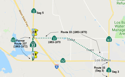 From Route 152 west of Los Banos to Route 5 near Santa Nella.
Post 1964 Signage HistoryAs defined in 1963, Route 33 included a segment running from "Route 152 to Route 140." The starting point on Route 152, however, was 10 mi west of where the original Route 33 branched off of Route 152 (Ingomar Grade and Henry Miller Road). A portion of that routing became Route 207 in the 1963 renumbering.
In 1970, the segment was shortened to "Route 5 near Santa Nella to Route 140", deleting the post-1963 routing of Route 33 between Route 152 and I-5 from the highway system.
In 1972, the former routing of Route 207 was transferred back to Route 33, creating this segment.
Pre 1964 Signage HistoryIn 1934, Route 33 was signed along the route from Maricopa to Jct. US 50 near Tracy, via Coalinga. The 1963 routing was signed as Route 33 (but was LRN 121) from approximately 10 mi W of Los Banos to the junction with LRN 41, approximetly where I-5 is today. The original routing, which was LRN 41, ran from Los Banos for 6 mi NW to Volta, and then 5 mi W to the junction with LRN 121, near the present I-5 (which was LRN 238). According to someone familiar with the area, this routing approximates with Henry Miller Avenue (the EW portion between Santa Nella and Volta) and the Ingomar Grade to Los Banos. That routing became Route 207, which later went back to being Route 33.
The original alignment of Route 33 from Santa Nella to Los Banos
originally followed Henry Miller Avenue, Ingomar Grade, H Street, 7th
Street and I Street. Route 33 was realigned in 1972 onto a multiplex
of Route 152 west of Los Banos and north over what was the original Route 207 to Santa Nella. 1972 Legislative Chapter 1216 transferred the
entirety of the original Route 207 to Route 33.
(Source: Gribblenation Blog (Tom Fearer), "California State Route 33 and legacy of US Route 399 on the Maricopa-Ventura Highway", August 2021)
Note: Tom Fearer has some excellent historical information on this segment in his Gribblenation Blog entry: California State Route 33; US 101 north to I–5 in Santa Nella.
NamingThis segment has historically been called El Camino Viejo.
StatusNote: The break between segments is cosigned Route 152/Route 33.
Freeway[SHC 253.3] Portion (4); not constructed to freeway standards. This was added to the Freeway and Expressway system in 1965.
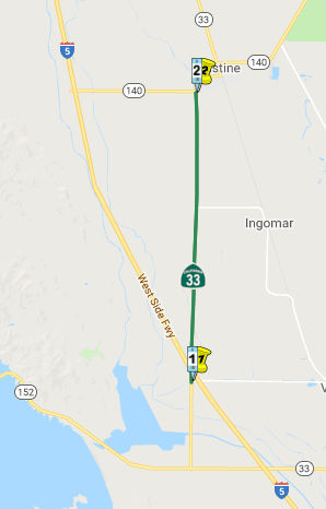 From Route 5 near Santa Nella to Route 140.
Post 1964 Signage HistoryAs defined in 1963, Route 33 included a segment (Henry Miller Road from Route 152 to Route 33) running from "Route 152 to Route 140." The starting point on Route 152, however, was 10 mi west of where the original Route 33 branched off of Route 152 (Ingomar Grade and Henry Miller Road). That original routing became Route 207 in the 1963 renumbering.
In 1970, the segment was shortened to "Route 5 near Santa Nella to Route 140", deleting the post-1963 routing of Route 33 between Route 152 and I-5 from the highway system. That is the source of the current segment (e).
Pre 1964 Signage HistoryIn 1934, Route 33 was signed along the route from Maricopa to Jct. US 50 near Tracy, via Coalinga. This segment was signed as Route 33 between LRN 121 (near the present-day I-5) and Route 140, but was LRN 41, defined in 1933.
StatusAlthough technically the route between (5) and (6) is legislatively Route 140, it is signed and named as Route 33. This segment is LRN 122, and was defined in 1959.
NamingThis segment has historically been called El Camino Viejo.
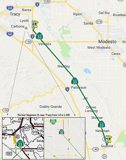 From Route 140 to Route 5 near Vernalis.
Post 1964 Signage HistoryThis segment was defined in 1963 as "(e) Route 140 to Route 205 near Tracy." In 1970, it was split into two segments: "(e) Route 140 to Route 5 near Vernalis. (f) Route 5 near Vernalis to Route 205 near Tracy." The act also stated that "the portion of this route described in subdivision (f) shall cease to be a state highway when Route 5 Freeway is constructed from Route 33 near Vernalis to Route 205."
In 1976, segment (f) was deleted by Chapter 1354.
Pre 1964 Signage HistoryIn 1934, Route 33 was signed along the route from Maricopa to Jct. US 50 near Tracy, via Coalinga. This segment was also part of LRN 41, defined in 1933.
StatusSperry Ave Roundabout (10-Sta-33 12.571)
In August 2025, the CTC approved amending the following
new project into the 2024 SHOPP: 10-Sta-33 12.571. PPNO 10-3692; ProjID
1022000222; EA 1Q020. Route 33 In the City of Patterson at the
intersection with Sperry Avenue/Route 130†. Construct
roundabout. Concurrent COS allocation under Resolution FP-25-23; August
2025. Allocation ($ × $1000): PA&ED $1,430; PS&E $2,320; R/W
Sup $549; ⊘Con Sup $1,665; ⊘R/W Cap $2,204; ⊘Const
Cap $8,387; TOTAL $16,555. BC: 10/30/2030. “⊘”
indicates phase not authorized. March 2026 Update: 2026 SHOPP
Confirmed.
† Note: Although stated and
apparently plausibly part of Route 130, Sperry Avenue is not in the
postmile database as part of Route 130; state-maintained Route 130 ends
at the top of Mt. Hamilton. Sperry Avenue is actually part of County Sign Route J17.
(Source: August 2025 CTC Agenda, Agenda Item 2.1a.(1a) #5; March
2026 CTC Agenda, Agenda Item 4.7)
In August 2025, the CTC approved the following
pre-construction phase allocation for a 2024 SHOPP project: $1,430,000.
10-Sta-33 12.571. PPNO 10-3692; ProjID 1022000222; EA 1Q020. Route 33 In
the City of Patterson at the intersection with Sperry Avenue/Route 130†.
Construct roundabout. Concurrent Amendment under SHOPP Amendment 24H-014;
August 2025. Pre-Construction Phase Allocation: Budgeted (Actual,
if different): PA&ED $1,430,000.
† Note: Although stated and
apparently plausibly part of Route 130, Sperry Avenue is not in the
postmile database as part of Route 130; state-maintained Route 130 ends
at the top of Mt. Hamilton. Sperry Avenue is actually part of County Sign Route J17.
(Source: August 2025 CTC Agenda, Agenda Item 2.5b.(2a) #20)
NamingThis segment has historically been called El Camino Viejo.
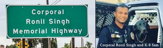 The portion of Route 33 from post mile MER 29.730 in the
County of Merced to post mile STA 2.060 in the County of Stanislaus is
named the Corporal Ronil Singh Memorial Highway. It was named in
memory of Corporal Ronil Singh, who, after immigrating to the United
States from the island nation of Fiji, settled in the County of
Stanislaus, where he studied criminal justice at Modesto Junior College in
2005 and fulfilled his dream of becoming a police officer. Corporal Singh
began serving his fellow Californians when he started his law enforcement
career as a cadet with the Turlock Police Department, and through his law
enforcement work as a reserve officer with the sheriff’s department
in the adjacent County of Merced. In 2011, Corporal Singh joined the
Newman Police Department, a tight-knit law enforcement agency in the City
of Newman, a still-rural central valley community where 13 sworn officers
continually seek to prevent crime and injustice, enforce the law fairly,
and defend the rights of the citizenry. These duties spoke to Corporal
Singh’s innate desire to do good in the world as a peace officer by
providing committed, unstinting, and consequential service. He was a
well-respected seven-year veteran of the Newman Police Department who was
frequently accompanied by his trained K-9 partner, Sam. While working in
the early morning hours of December 26, 2018, Corporal Singh, 33 years of
age, a much-loved husband, father, and peace officer with the Newman
Police Department, was killed in the line of duty. Named By Assembly
Concurrent Resolution (ACR) 128, Res. Chapter 42, 09/14/20. The sign was
dedicated in September 2023.
The portion of Route 33 from post mile MER 29.730 in the
County of Merced to post mile STA 2.060 in the County of Stanislaus is
named the Corporal Ronil Singh Memorial Highway. It was named in
memory of Corporal Ronil Singh, who, after immigrating to the United
States from the island nation of Fiji, settled in the County of
Stanislaus, where he studied criminal justice at Modesto Junior College in
2005 and fulfilled his dream of becoming a police officer. Corporal Singh
began serving his fellow Californians when he started his law enforcement
career as a cadet with the Turlock Police Department, and through his law
enforcement work as a reserve officer with the sheriff’s department
in the adjacent County of Merced. In 2011, Corporal Singh joined the
Newman Police Department, a tight-knit law enforcement agency in the City
of Newman, a still-rural central valley community where 13 sworn officers
continually seek to prevent crime and injustice, enforce the law fairly,
and defend the rights of the citizenry. These duties spoke to Corporal
Singh’s innate desire to do good in the world as a peace officer by
providing committed, unstinting, and consequential service. He was a
well-respected seven-year veteran of the Newman Police Department who was
frequently accompanied by his trained K-9 partner, Sam. While working in
the early morning hours of December 26, 2018, Corporal Singh, 33 years of
age, a much-loved husband, father, and peace officer with the Newman
Police Department, was killed in the line of duty. Named By Assembly
Concurrent Resolution (ACR) 128, Res. Chapter 42, 09/14/20. The sign was
dedicated in September 2023.
(Image source: The PineTree.Net; Image source: The Hindu, 9/5/2023)
 Other WWW Links
 Statistics
Overall statistics for Route 33:
 Pre-1964 Legislative Route
The routing that become LRN 33 was first defined in the 1916 Second Bond Issue as "an extension connecting the San Joaquin valley trunk line at or near Bakersfield with the coast trunk line in San Luis Obispo county, through Cholame pass, by the most direct and practical route;". In 1933, the routing was extended "[LRN 56] near Cambria to [LRN 2] near Paso Robles" (i.e., to the coast route). It was codified in the highway code in 1935 as:
This routing remained unchanged until the 1963 renumbering. It was signed as follows:
© 1996-2024 Daniel P. Faigin.
Maintained by: Daniel P. Faigin
<webmaster@cahighways.org>.
 Route 32
 Route 34