
 California Highways:
Click here for a key to the symbols used. An explanation of acronyms may be found at the bottom of the page.
 Routing
 Post 1964 Signage History
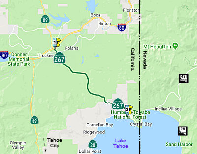
In 1965, Chapter 1425 defined Route 267 as “Route 80 near Truckee to Route 28 near Kings Beach, Lake Tahoe via Northshore Boulevard.”
A bypass for Route 267 in Truckee has been constructed to get all the
Tahoe-bound traffic out of central Truckee. The Route 89 portion of the
alignment is short; most of the bypass is for Route 267. The bypass
includes a long viaduct across the Truckee River, which is visible as you
come off the hill near the Central Truckee exit. This bypass is a 2 lane
expressway with sufficient right of way to expand it to 4 lanes when
needed. From the old interchange, the east and west bound on ramp will
remain to provide the town with direct highway access. The original
alignment of Route 267 continued into downtown Truckee on Old Brockway
Road and to I-80/Route 89 on Donner Pass Road1.
(Note: 1: Gribblenation Blog: California State Route 267, 10/16/18)
 Pre 1964 Signage History
This routing was first defined post 1963. The future alignment of Route 267 appears as a well maintained county route between Truckee over
Brockway Summit to Lake Tahoe on the California Division of Highways maps
of Nevada/Placer County in 19351.
(Note: 1: Gribblenation Blog: California State Route 267, 10/16/18)
 Status
Route 28/Route 267 Roundabout (03-PLA-028 8.9/9.5,
03-PLA-267 9.7/9.898)
In May 2022, the CTC approved for future consideration
of funding the following project: 03-PLA-028 8.9/9.5, 03-PLA-267
9.7/9.898. Kings Beach Western Approach Project. Construct a
roundabout at the intersection of Route 28 and Route 267. (MND) (PPNO
5403) (ATP) Specifically, the Project will construct a roundabout at the
intersection of Route 28 and Route 267. The project also includes the
reconfiguration of an existing midblock crosswalk and a road diet on
adjacent portions of Route 28 to improve safety.
(Source: May 2022 CTC Agenda, Agenda Item 2.2c.(3))
In June 2023, the CTC authorized the following District
Minor Project financial allocation: $1,250,000. 03-Pla-28 8.9/9.5. PPNO
—; ProjID 0318000146; EA 0C932. In Placer County, on Route 28 in
Kings Beach at the Route 28/Route 267 Intersection. Outcome/Output:
Construct roundabout. This is a substitute project for EA 1J400. Financial
Contribution Only (FCO) to the County of Placer. Future Consideration of
Funding approved under Resolution E-22-32; May 2022.
(Source: June 2023 CTC Agenda, Agenda Item 2.5a #1)
 Naming
 In Truckee is the "Truckee Round House Historic Plaque", named by
Senate Concurrent Resolution 76, Chapter 106, in 1992. The Truckee
Roundhouse Historical Plaque marks the location of the Central Pacific
Railroad roundhouse maintenance facility from 1868 to 1942. The plaque
reads: "C.P.R.R Truckee Round House: Needed to house and maintain
the engines of the Central Pacific Railroad during construction of the
Trans-Sierra Crossing, an enclosed wooden round house was
constructed here in 1868. It was razed by fire in March 1869. A 16 stall
wooden structure was built that year as the maintenance facility of the
C.P.R.R. Truckee Division. Another fire in 1876 resulted in construction
of a 22 stall granite and wooden structure. This served thru 1942, when it
was officially retired. A victim of the end of the steam era and
consolidation of maintenance at other locations. The round houses were
home to helper engines, fire trains and the first rotary snow plow
in the Sierra. Dedicated August 10, 1991 Chief Truckee Chapter No. 3691. E
Clampus Vitus."
In Truckee is the "Truckee Round House Historic Plaque", named by
Senate Concurrent Resolution 76, Chapter 106, in 1992. The Truckee
Roundhouse Historical Plaque marks the location of the Central Pacific
Railroad roundhouse maintenance facility from 1868 to 1942. The plaque
reads: "C.P.R.R Truckee Round House: Needed to house and maintain
the engines of the Central Pacific Railroad during construction of the
Trans-Sierra Crossing, an enclosed wooden round house was
constructed here in 1868. It was razed by fire in March 1869. A 16 stall
wooden structure was built that year as the maintenance facility of the
C.P.R.R. Truckee Division. Another fire in 1876 resulted in construction
of a 22 stall granite and wooden structure. This served thru 1942, when it
was officially retired. A victim of the end of the steam era and
consolidation of maintenance at other locations. The round houses were
home to helper engines, fire trains and the first rotary snow plow
in the Sierra. Dedicated August 10, 1991 Chief Truckee Chapter No. 3691. E
Clampus Vitus."
(Image source: Waymarking)
 The Route 267 bypass in
Truckee is named the "CHP Officer Glenn Carlson Memorial Bypass".
California Highway Patrol Officer Glenn Carlson died in the line of duty
at 33 years of age during a traffic stop near the foot of Donner Summit on
November 15, 1963. He had stopped a trio of men after learning that the
license plates on their car were stolen, but not knowing that the three
men had robbed a bank in Sacramento and were making their escape. He was
fatally shot as he stepped out of his patrol unit by one of the men
enabling the fugitives to temporarily escape. All three men were
ultimately arrested, prosecuted, and convicted for their crimes. Officer
Carlson's death was the catalyst for then California Highway Patrol
Commissioner Brad Crittenden to seek additional officers, and within two
years of Officer Carlson's death, the number of uniformed officers was
doubled. Named by Assembly Concurrent Resolution 138, Chapter 95, July 12,
2000. His granddaughter, Kelly Cox, has a particularly nice page of remembrance.
The Route 267 bypass in
Truckee is named the "CHP Officer Glenn Carlson Memorial Bypass".
California Highway Patrol Officer Glenn Carlson died in the line of duty
at 33 years of age during a traffic stop near the foot of Donner Summit on
November 15, 1963. He had stopped a trio of men after learning that the
license plates on their car were stolen, but not knowing that the three
men had robbed a bank in Sacramento and were making their escape. He was
fatally shot as he stepped out of his patrol unit by one of the men
enabling the fugitives to temporarily escape. All three men were
ultimately arrested, prosecuted, and convicted for their crimes. Officer
Carlson's death was the catalyst for then California Highway Patrol
Commissioner Brad Crittenden to seek additional officers, and within two
years of Officer Carlson's death, the number of uniformed officers was
doubled. Named by Assembly Concurrent Resolution 138, Chapter 95, July 12,
2000. His granddaughter, Kelly Cox, has a particularly nice page of remembrance.
(Image source: Kelly L. Cox; Tahoe Daily Tribune)
 The five-mile portion of Route 267 from PLA 4.898 to the end of Route 267 at PLA 9.898 in the
County of Placer, is named the "Senator Paul J. Lunardi Memorial
Highway". It was named in memory of Paul J. Lunardi, who was born
in September 1921, in Roseville, California, and lived his entire life at
the family home on Earl Avenue. Upon his graduation from Roseville High
School, Lunardi enlisted in the United States Coast Guard during World War
II. After the war, he was elected to the Roseville City Council in 1950
and 1954, winning the mayoral seat in the latter year. During his tenure
on the city council, Lunardi was instrumental in the adoption of a city
charter for the council-manager form of government and successfully
established a community hospital, developed a municipal fire department,
established an updated street lighting system, obtained central valley
federal power for the city, and expanded sewage, water, and electric
distribution systems. His outstanding record of achievement earned Lunardi
a highly coveted “Outstanding Young Men of California” award
presented by the State Junior Chamber of Commerce on January 8, 1955.
Lunardi was elected to the State Assembly in 1958, representing the 6th
Assembly District, which spanned 11 mountain counties. He served in the
Assembly until 1963 when he was elected to the State Senate to represent
the 7th Senate District, which included the Counties of Sierra, Nevada,
and Placer. He retired in 1966 due to redistricting. One of Senator
Lunardi’s proudest accomplishments was his legislation designating
the ghost town of Bodie as a State Historic Park. Bodie is now listed on
the National Register of Historic Places and is one of the best preserved
and most visited (200,000 people a year) ghost towns in the nation.
Senator Lunardi introduced the first bill in the state’s history to
assess farmland at a lower tax rate. The bill later passed with the help
of Assembly Member John Williamson and is now known as the Williamson Act.
Skiers and mountain residents still benefit from one of Senator
Lunardi’s major legislative accomplishments that designated the
“Truckee shortcut” as Route 267, that links the City of
Truckee to Kings Beach. Prior to 1965, the road was regularly closed by
snow in the winter. Senator Lunardi’s legislation enabled the road
to remain open year-round, worth millions of dollars to the area’s
tourism and ski industries, and allowed for the development of Northstar
Ski Resort. Senator Lunardi was honored in 2008 when his hometown of
Roseville dedicated a park in his name, to honor his civic achievements
and his dedication to the community where he lived his entire life.
Senator Lunardi passed away peacefully on January 11, 2013, at 91 years of
age and was laid to rest in his beloved Roseville, California. Named by
Senate Concurrent Resolution (SCR) 23, Res. Chapter 141, Statutes of 2015,
on August 26, 2015.
The five-mile portion of Route 267 from PLA 4.898 to the end of Route 267 at PLA 9.898 in the
County of Placer, is named the "Senator Paul J. Lunardi Memorial
Highway". It was named in memory of Paul J. Lunardi, who was born
in September 1921, in Roseville, California, and lived his entire life at
the family home on Earl Avenue. Upon his graduation from Roseville High
School, Lunardi enlisted in the United States Coast Guard during World War
II. After the war, he was elected to the Roseville City Council in 1950
and 1954, winning the mayoral seat in the latter year. During his tenure
on the city council, Lunardi was instrumental in the adoption of a city
charter for the council-manager form of government and successfully
established a community hospital, developed a municipal fire department,
established an updated street lighting system, obtained central valley
federal power for the city, and expanded sewage, water, and electric
distribution systems. His outstanding record of achievement earned Lunardi
a highly coveted “Outstanding Young Men of California” award
presented by the State Junior Chamber of Commerce on January 8, 1955.
Lunardi was elected to the State Assembly in 1958, representing the 6th
Assembly District, which spanned 11 mountain counties. He served in the
Assembly until 1963 when he was elected to the State Senate to represent
the 7th Senate District, which included the Counties of Sierra, Nevada,
and Placer. He retired in 1966 due to redistricting. One of Senator
Lunardi’s proudest accomplishments was his legislation designating
the ghost town of Bodie as a State Historic Park. Bodie is now listed on
the National Register of Historic Places and is one of the best preserved
and most visited (200,000 people a year) ghost towns in the nation.
Senator Lunardi introduced the first bill in the state’s history to
assess farmland at a lower tax rate. The bill later passed with the help
of Assembly Member John Williamson and is now known as the Williamson Act.
Skiers and mountain residents still benefit from one of Senator
Lunardi’s major legislative accomplishments that designated the
“Truckee shortcut” as Route 267, that links the City of
Truckee to Kings Beach. Prior to 1965, the road was regularly closed by
snow in the winter. Senator Lunardi’s legislation enabled the road
to remain open year-round, worth millions of dollars to the area’s
tourism and ski industries, and allowed for the development of Northstar
Ski Resort. Senator Lunardi was honored in 2008 when his hometown of
Roseville dedicated a park in his name, to honor his civic achievements
and his dedication to the community where he lived his entire life.
Senator Lunardi passed away peacefully on January 11, 2013, at 91 years of
age and was laid to rest in his beloved Roseville, California. Named by
Senate Concurrent Resolution (SCR) 23, Res. Chapter 141, Statutes of 2015,
on August 26, 2015.
(Image source: Gaines Gazette; Sierra Sun)
 Interregional Route
[SHC 164.19] Entire route.
 Other WWW Links
 Statistics
Overall statistics for Route 267:
 Pre-1964 Legislative Route
In 1959, Chapter 1062 defined LRN 267 as “[LRN 59] to [LRN 266] near the San Bernardino county line”. This is proposed Route 48 from the Route 14/Route 138 junction to Route 122 near the San Bernardino County Line.
The 1963 map also shows LRN 267 as applying to the portion of Route 138 between I-5 and Route 14. That segment was LRN 59. Evidently, the straight-line segment would have become LRN 267 upon the completion of a new routing for LRN 59 to the S directly into Palmdale.
© 1996-2020 Daniel P. Faigin.
Maintained by: Daniel P. Faigin
<webmaster@cahighways.org>.
 From Route
  Route 266
 Route 268