
 California Highways:
Click here for a key to the symbols used. An explanation of acronyms may be found at the bottom of the page.
 Routing
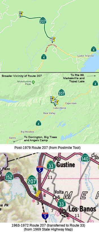 FromRoute 4 near Lake Alpine to the Mt. Reba Ski Area.
Note: The Mount Reba Ski Area was sold in 1991 and is presently known as the Bear Valley Ski Area.
 Post 1964 Signage History
 In 1963, Route 207 was defined as the route "Route 152 west of Los
Banos to Route 33." That segment was signed as Route 33 before the 1964
renumbering, but was renumbered to be Route 207 when Route 33 was moved 10
mi W. to start at a different point in Route 152.
In 1963, Route 207 was defined as the route "Route 152 west of Los
Banos to Route 33." That segment was signed as Route 33 before the 1964
renumbering, but was renumbered to be Route 207 when Route 33 was moved 10
mi W. to start at a different point in Route 152.
In 1972, Chapter 1216 transferred this routing back to Route 33.
In 1979, Chapter 572 redefined Route 207 as "Route 4, 1.35 miles
west of Lake Alpine, to the Mt. Reba Ski Area."
In 1984, Chapter 409 relaxed the definition to "Route 4 1.35
miles west of near Lake Alpine to the Mt. Reba Ski
Area."
Note: The Mount Reba Ski Area was sold in 1991 and is presently known as the Bear Valley Ski Area.
 Pre 1964 Signage History
 The 1964-1972 routing of Route 207 was part of LRN 121, defined in
1933.
The post-1979 routing of Route 207 was not a part of the state
highway system before 1964. The route is Mt. Reba Road.
 Status
Route 207 is signed in advance and at the exit from Route 4, as well as having reassurance shields.
In June 2021, it was reported that Construction was scheduled on Route 207 from the Route 4 junction to Mt. Reba Resort, and on Route 4 near
Tamarack from west of Cabbage Patch Log Road (Forest Rte 7N09, ~
10-CAL-004 R59.8) to the Alpine County line (~ 10-CAL-004 R65.855). In
addition to rehabilitating the road surface, the highway will be widened,
re-striped, damaged culverts will be repaired, and rumble strips will be
installed to improve motorists’ safety. Work is scheduled to
continue into Fall 2021. The estimated $4.25 million project will be
performed by George Reed Construction Inc., of Modesto, CA.
(Source: The Pine Tree, 6/15/2021)
 Interregional Route
[SHC 164.19] Entire route.
 Other WWW Links
 Statistics
Overall statistics for Route 207:
 Pre-1964 Legislative Route
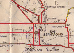 In 1937, Chapter 15 added the route from “[LRN 190]
near Highland northeasterly to [LRN 43]; also from a point on said [LRN 43] near where it crosses Deep Creek, thence northeasterly to and
connecting with Forest Service North Side Road in Green Valley”.
This was added because the existing road into Big Bear was inadequate for
the traffic. It also noted there would be a Federal Grant for the road.
The map to the right (from 1944) shows how LRN 207 branched from LRN 190
(Route 30/Route 38 junction).
In 1937, Chapter 15 added the route from “[LRN 190]
near Highland northeasterly to [LRN 43]; also from a point on said [LRN 43] near where it crosses Deep Creek, thence northeasterly to and
connecting with Forest Service North Side Road in Green Valley”.
This was added because the existing road into Big Bear was inadequate for
the traffic. It also noted there would be a Federal Grant for the road.
The map to the right (from 1944) shows how LRN 207 branched from LRN 190
(Route 30/Route 38 junction).
In 1939, Chapter 473 deleted and recreated the route as [LRN 207].
In 1941, Chapter 142 removed the northern branch.
In 1949, Chapter 1467 added the route that would become LRN 232 as LRN 207: “[LRN 207] is from Sacramento to Marysville; provided, however, that Section 600 of the Streets and Highways Code shall be applicable to the route added to the State Highway System by this section the same as if said route had been added by the Collier-Burns Highway Act of 1947, and the Department of Public Works shall not be required to maintain any portion of said route until the same has been laid out and constructed as a state highway” In 1951, Chapter 1562 renumbered this duplicate [LRN 207] as [LRN 232].
By 1963, this route ran from Route 30 near Highland northeasterly to Route 18. This was signed as Route 30, and ran from the present Route 30/Route 330 junction to Route 18. It is present-day Route 330.
© 1996-2020 Daniel P. Faigin.
Maintained by: Daniel P. Faigin
<webmaster@cahighways.org>.
 Route 206
 Route 208