
 California Highways:
Click here for a key to the symbols used. An explanation of acronyms may be found at the bottom of the page.
 Routing
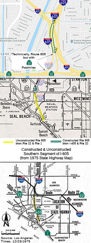 From Route 1 near Seal Beach to Route 405.
 Post 1964 Signage History
In 1963, Route 605 was defined as "Route 405 to Route 10 near the San Gabriel River."
In 1964, it was noted that "Similarly, the southern extension, from the San Diego Freeway to the Pacific Coast Highway, is noninterstate. It is now designated as Route 240. Studies leading to adoption of the route are in a preliminary stage."
On 5/18/1966, the CHC adopted a routing for the Route 605 freeway between Route 22 and Route 1.
In 1968, Chapter 282 added segment (a) and (c): "(a) Route 1 near Seal Beach to Route 405. (b) Route 405 to Route 10 near the San Gabriel River. (c) Route 10 to Route 210 near Duarte." Segment (a) was a transfer from Route 240 (defined in 1964).
In 1975, Caltrans published a Notice of Intent to rescind the route
adoption for the portion of Route 605 between Route 1 and Route 22.
(Source: Los Angeles Times, 12/23/1975, via Joel Windmiller,
2/23/2023)
 Pre 1964 Signage History
This was LRN 170. The portion between Route 22 and I-10 was defined in 1933; the portion between Route 1 and Route 22 in 1957; and the remainder in 1959.
 Status
 The portion between Route 1 and Route 22 is unconstructed. The
routing is roughly Seal Beach Blvd, although this does not meet the
definition of a traversable highway. In 1965, it was planned to connect to the Pacific Coast Freeway (Route 1).
The portion between Route 1 and Route 22 is unconstructed. The
routing is roughly Seal Beach Blvd, although this does not meet the
definition of a traversable highway. In 1965, it was planned to connect to the Pacific Coast Freeway (Route 1).
The 2013 Traversable Highways report notes for the portion from Route 1 to Route 22, no local roads adequately fit the description of traversable highway. No plans.
DTComposer noted on AARoads: (edited slightly):
(Source: DTComposer on AARoads, "Re: CA 22", 1/30/2018)
There are several vestiges of this planned routing in the street and property lines: Nassau Drive curves as it does to accommodate where I-605 would come in just above it (which is why Leisure World didn't develop that part of their property). The concrete alignment appears to mean a new bridge for WB Route 22 would have been built between the existing bridge and College Park Drive, and EB Route 22 shifted north onto the current WB bridge. The existing EB Route 22 bridge would have been modified/removed to accommodate the ramp from EB Route 22 to SB I-605 (or Route 240 as it was on the books back then). Moving west, the freeway extension would have left 7th Street and curved southwest along Parima Street (6th Street was built on this curve to accommodate the freeway); Parima Street and Lausinda Avenue (as well as the developments to the west) were built after the freeway plans were abandoned. The extension would have met Pacific Coast Highway at Colorado Street (you can see the property line between Storybrook Villas and the Assumption of the Blessed Virgin curves to allow for a ramp (again, that church was not built until after the freeway was shelved)). It would have then followed/paralleled Colorado Street to Appian Way, where it would turn northwest and follow the old Pacific Electric right-of-way to somewhere between 10th Street and Anaheim Street, and would move within this corridor until it reached I-710 around Anaheim Street (somewhere there is a Thomas Bros. map that shows a precise corridor for this). It then continued west across Wilmington and Harbor City to until the Five Points intersection (Anaheim Street/Gaffey Street/Vermont Avenue/Palos Verdes Drive). This extension would have been Route 1 (Route 22 would have still ended in east Long Beach) and was known as the Crosstown Freeway and was originally part of the larger plan to make Route 1 a freeway from Santa Monica to Dana Point. Other sections of the freeway plan were dropped throughout the 1960s and '70s, and this "orphaned" section was finally dropped in 1978.
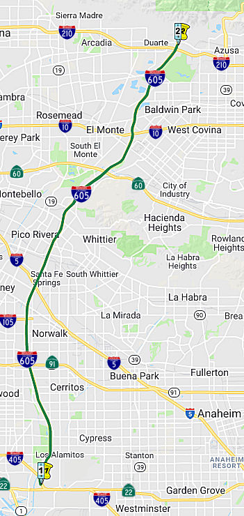 From Route 405 to Route 210 near Duarte.
Post 1964 Signage HistoryIn 1963, Route 605 was defined as "Route 405 to Route 10 near the San Gabriel River."
In 1964, it was noted that "The northerly extension of the San Gabriel River Freeway, 5.4 miles in length, between the San Bernardino Freeway and the future Foothill Freeway, is being designed and right-of-way is being acquired. This section, not on the interstate system, is now designated as Route 243. Construction is about four years in the future (1968)."
On July 1, 1966, the segment of I-605 between I-405 and I-5 opened.
Construction costs were $24,610,000. At the time, additional extensions
were not planned as Interstate (Route 243 and Route 240).
(Source: CHPW, Jan/Feb 1967)
In 1968, Chapter 282 added segment (a) and (c): "(a) Route 1 near Seal Beach to Route 405. (b) Route 405 to Route 10 near the San Gabriel River. (c) Route 10 to Route 210 near Duarte." Segment (c) was transferred from Route 243. The Route 243 segment was approved for interstate construction as part of the December 1968 Federal Aid Highway act, which provided $19.0 million for the 5.5 mile segment. Segment (a) was a transfer from Route 240.
In 1984, Chapter 409 combined (b) and (c): "(b) Route 405 to Route 210 near Duarte."
The freeway started construction in 1964, and was extended north to the I-210 in 1971.
Pre 1964 Signage HistoryThis was LRN 170. The portion between Route 22 and I-10 was defined in 1933; the portion between Route 1 and Route 22 in 1957; and the remainder in 1959. On 12/15/1954, the CTC adopted a freeway routing for the future I-605 between the San Diego Freeway and the San Bernardino Freeway (Sign Route 7 and US 70-99 then, now I-405 and I-10). The surface street routing for LRN 170 was Sign Route 35.
Sign Route 35 started at Sign Route 22 (LRN 79), Garden Grove Blvd. It followed Los Alamitos Blvd N to Pioneer Blvd, along Pioneer to San Antonia Drive, and along San Antonia to Santa Fe Springs. It then followed Norwalk Blvd and Workman Will Blvd to Protector Avenue. It continued along Protector Avenue as Puente Avenue to US 70/US 99/US 60 (LRN 26).
In 1959, the Division of Highways announced a 1.3-mile realignment of Sign Route 35/LRN 170 from Workman Mill Road to the San Gabriel River Freeway was budgeted for the FY1960-61.In the 1964 renumbering, Route 35 was reallocated to former Sign Route 35. I-605 was assigned to the segment between I-405 and I-10; Route 240 to
the portion S to Route 1; and Route 243 allocated to the segment N of
I-10. The first segments of I-605 opened on 6/10/1964 between Peck and
Whittier Blvds.
(Source: Gribblenation Blog (Tom Fearer), Interstate 605, 1/2023)
StatusIn December 2005, utilizing Measure M money, the OCTA authorized construction of HOV connector ramps between I-405 and I-605.
Katella Interchange (~ ORA R1.392)
In June 2017, it was reported that OCTA, in partnership
with Caltrans, has initiated an Improvement Project to enhance safety,
smooth traffic flow, and improve pedestrian and bicycle pathways through
the I-605/Katella Avenue interchange in the City of Los Alamitos. The
project is in the preliminary engineering and environmental review stage
to identify potential significant environmental effects and ways to avoid
or significantly reduce those effects. Funded by Measure M, Orange
County’s voter-approved transportation investment plan, the
environmental review process began in mid-2016 and is expected to be
completed in late 2018. During this time, improvements to Katella Avenue,
freeway ramps and bicycle and pedestrian facilities will be studied to
determine their benefits, costs and impacts.
(Source: OCTA Blog, 6/20/2017)
In May 2018, public meetings started on the draft environmental document. The project proposes to improve the local interchange at I-605 and Katella Avenue, located in the western portion of the City which is located in western Orange County. The proposed project is intended to improve freeway access and arterial connection, improve interchange traffic operations, enhance safety, and improve pedestrian and bicycle facilities within the interchange area. According to the DED, the I-605/Katella Avenue interchange currently experiences roadway and operational deficiencies in the form of inefficient traffic operations and deficiencies in community mobility for automobiles, pedestrians, and bicycle traffic. Constructed approximately fifty years ago in the 1960’s in conjunction with the I-605 freeway improvements, the I-605/Katella Avenue interchange configuration is a mix of loop and direct ramp configurations that reflect the constraints of the Coyote Creek Channel. It is a modified full cloverleaf configuration with loop ramps in all quadrants except the southeast quadrant which contains a direct exit ramp from northbound I-605. Existing bridges over Katella Avenue are fourspan reinforced concrete box girder bridges supported on concrete pile foundations. A direct exit ramp from southbound I-605 is located to the west of the Coyote Creek Channel, outside the project limits. All ramp termini incorporate free-right movements.
The project area includes the interchange ramps and
Katella Avenue, from the Coyote Creek Channel Bridge to Civic Center
Drive. The project would modify interchange ramps and Katella Avenue. The
existing I-605 mainline would not be modified, with the exception of the
northbound No. 4 lane at the northbound exit ramp. This lane would be
restriped from a through lane to a through lane/exit option lane to
accommodate a proposed 2nd exit ramp lane. Katella Avenue would be widened
and lane geometries would be modified to provide standard lanes and
shoulders through the interchange and tie in with proposed ramp
improvements.
(Source: OCTA Blog, 5/1/2018)
In January 2019, the CTC approved for future
consideration of funding 12-Ora-605, PM 1.1/1.6 I-605/Katella Avenue
Interchange Improvements Project. This project is at the I-605 and
Katella Avenue, in the city of Los Alamitos, in Orange County and proposes
to improve the interchange traffic operations and pedestrian and bicycle
facilities within the project limits. This project is intended to bring
the highway alignment up to current design standards and extend the
service life of the pavement. The total estimated project cost is $30.6
million; with $1.2 million currently entered in the 2017 Federal
Transportation Improvement Program and expected to be funded from Orange
County local measure funds for the Project Approval and Environmental
Document phase of this project. Additional funding for the proposed
project is to be determined and anticipated to be combined from State,
Federal and local sources. Construction is estimated to begin in
fiscal year 2033-34. (!!)
(Source: January 2019 CTC Minutes, Agenda Item 2.2c(1))
In April 2012, the CTC authorized SHOPP funding on I-605, in Los Angeles County, 07-LA-605 R0.1/R16.6 In Los Angeles County through various cities, from Coyote Creek Bridge to Peck Road. $588,000 to construct 11,500 feet of metal beam guardrail, and 2,000 feet of concrete barrier at locations of high embankments, trees, and fixed objects. The project will improve safety by reducing the severity of run-off-the road collisions.
In August 2011, the CTC approved $2,033,000 in SHOPP funding for repairs in and near Pico Rivera, from 195th Street to Route 210 (~ LA R3.398 to LA 25.665), that will repair bridge decks and replace joint seals on 22 bridges to extend the service life of the structures.
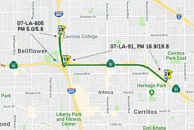
Route 605 / Route 91 Interchange Improvements (07-LA-605, PM 5.0/5.8)
 The SAFETEA-LU act, enacted in August 2005 as the reauthorization of TEA-21, provided the
following expenditures on or near this route:
The SAFETEA-LU act, enacted in August 2005 as the reauthorization of TEA-21, provided the
following expenditures on or near this route:
In January 2018, it was reported that Metro and
Caltrans District 7, in collaboration with the Gateway Cities Council of
Governments (GCCOG), are proposing to make improvements along westbound
Route 91, between the I-605/Route 91 (091 LA R16.935) Interchange and
Shoemaker Avenue (091 LA R19.818), and at the I-605 northbound exit to
Alondra Boulevard (605 LA R5.834). Proposed improvements in the Westbound SR-91 Improvement Project include adding auxiliary lanes, one new general purpose lane in the westbound direction, a lane at the I-605/Route 91 interchange off-ramp, enhancing freeway entrance and exit ramps, and
additional improvements on the arterial streets in the vicinity. Technical
studies for the project are still underway as of January 2018.
(Source: Metro "The Source", 1/25/2018)
In April 2018, it was reported that Metro was applying
for TCRP (Trade Corridor Relief Program) funds in addition to SB1 funds
for Route 605 / Route 91 Interchange Improvement project.
(Source: Metro The Source, 4/19/2018)
In March 2019, the CTC approved for future
consideration of funding a project is located on Route 91 from Shoemaker
Avenue to I-605, and on I-605 from Alondra Boulevard to the I-605/Route 91
Interchange in the cities of Cerritos and Artesia (07-LA-91, PM 16.9/19.8,
07-LA-605, PM 5.0/5.8). The purpose of the project is to reduce congestion
and improve freeway operations, safety and local and system interchange
operations. The proposed project includes additional freeway mainline
capacity leading to westbound Route 91 connector ramp to northbound and
southbound I-605, improvements to freeway entrance and exit ramps in the
westbound direction of Route 91 and operational improvements for the
northbound I-605 at the Alondra Boulevard off-ramp. This project proposes
to address the inadequate capacity of the existing two-lane connector for
westbound Route 91 to I-605. This project is fully funded and currently
programmed in the 2018 State Transportation Improvement Program (STIP) for
approximately $187.8 million. Construction is estimated to begin in 2022.
The scope, as described for the preferred alternative, is consistent with
the project scope programmed by the Commission in the 2018 STIP. The CTC
also approved an allocation of $26,000,000 for the multi-funded
locally-administered Senate Bill 1 (SB 1) Trade Corridors Enhancement
Program (TCEP)/State Transportation Improvement Program (STIP) Route 605/Route 91 Interchange Improvement: Gateway Cities Freight Crossroads
Project (PPNO 5388), on the State Highway System, in Los Angeles County.
(Source: March 2019 CTC Minutes, Agenda Item 2.2c.(1); March2019
CTC Minutes Agenda Item 2.5s.(7))
In December 2020, it was reported that the CTC approved
$118 million in Trade Corridor Enhancement Program funds for Route 91
Goods Movement Corridor Projects. The money will help modify the
I-605/Route 91 interchange to improve and add capacity to the connector
ramps, add an auxilliary lane on eastbound Route 91 between I-710 and
Cherry Avenue and help bring Route 91 up to current freeway standards.
(Source: Metro "The Source" 12/2/2020)
In January 2016, the CTC approved the following SHOPP funding: 7-LA-605 R10.1/15.7 I-605: In Pico Rivera and Whittier, from Telegraph Road to Rose Hills Road; also in El Monte and Baldwin Park from Ramona Boulevard to Route 210 (PM 20.9/25.6). Replace damaged concrete slabs, grind and groove concrete pavement to increase roadway surface friction during wet conditions. $12K (R/W); $4,618K (C) Completion ~ Sep 2018.
In March 2012, Caltrans began construction of a $14-million sound wall project along the 605 freeway in the city of Whittier and unincorporated county (~ LA R12.971). The project consists of approximately three miles of sound walls on both sides of the freeway with a scheduled completion of winter 2013. Metro funded the entire $14 million from Prop C and Measure R monies.
I-605 Corridor Improvement Project
 In 2020, it was reported that growth in the region’s population, employment, as
well as in goods movement, are expected to further pressure the existing
traffic capacity and operations on I-605. To ease congestion and support
future growth, operational, capacity and safety improvements are needed
for residents, businesses, travelers, and interstate commerce. Metro, in
collaboration with Caltrans District District 7, the Gateway Cities
Council of Governments (GCCOG) and the San Gabriel Valley Council of
Governments (SGVCOG), is proposing improvements along I-605 between I-105
and I-10 as part of the I-605 Corridor Improvement project (project). The
project also proposes to include improvements to the following major
interchanges: I-105, I-5, Route 60 and I-10. Improvements to I-605 will
enhance free operations, improving chronic traffic problems on one of
Southern California’s most congested freeways. A range of project
alternatives have been developed. In general, all proposed build
alternatives feature widening of the I-605 mainline freeway. The I-605
project proposes improvements from approximately two miles south of the
I-105 interchange to approximately two miles north of the I-10
Interchange; including enhancements to the Route 60, I-5, I-10 and I-105
interchanges. Project alternatives include:
In 2020, it was reported that growth in the region’s population, employment, as
well as in goods movement, are expected to further pressure the existing
traffic capacity and operations on I-605. To ease congestion and support
future growth, operational, capacity and safety improvements are needed
for residents, businesses, travelers, and interstate commerce. Metro, in
collaboration with Caltrans District District 7, the Gateway Cities
Council of Governments (GCCOG) and the San Gabriel Valley Council of
Governments (SGVCOG), is proposing improvements along I-605 between I-105
and I-10 as part of the I-605 Corridor Improvement project (project). The
project also proposes to include improvements to the following major
interchanges: I-105, I-5, Route 60 and I-10. Improvements to I-605 will
enhance free operations, improving chronic traffic problems on one of
Southern California’s most congested freeways. A range of project
alternatives have been developed. In general, all proposed build
alternatives feature widening of the I-605 mainline freeway. The I-605
project proposes improvements from approximately two miles south of the
I-105 interchange to approximately two miles north of the I-10
Interchange; including enhancements to the Route 60, I-5, I-10 and I-105
interchanges. Project alternatives include:
(Source/Image Source: I-605 Corridor Improvement Project Page, 7/22/2020)
In July 2020, it was announced that the project website
had been updated, and provided an overview of the alternatives and
proposed local improvements for each of the project freeways, interchanges
and local jurisdictions. It also provided project materials, including:
fact sheets, maps, graphics, schedules, resource information on the
environmental process and past reports and hearings for reference. Metro
was planning for the Draft Environmental Document (Draft ED) to be
circulated in late Summer 2020.
(Source: Metro The Source, 7/7/2020)
In October 2020, it was reported that the “I-605
Corridor Improvement Project” includes more than 360 full
acquisitions of properties, over 320 partial acquisitions, and over 540
easements. Though there are impacts throughout the project, the
lion’s share of the sites to be torn down are concentrated in the
city of Downey. About two-thirds of full acquisitions would be in Downey,
as well as about half of partial acquisitions. The main source of the
project planned acquisitions through Downey is not actually along I-605,
but is more focused along the I-5 corridor. Metro’s I-5 widening
plans appear to target more demolition on the north side of I-5 than on
the south. The area on the south side of the freeway is known as
“Downey Estates,” where many homes are valued at a million
dollars. Although the EIR public comment period was planned to start in
September 2020, it has been postponed to a date in early 2021.
(Source: Streetsblog LA, 10/2/2020)
In January 2021, it was reported that a banner reading
“NO MORE LANES” was placed on a pedestrian overcrossing
over I-5 Freeway in the city of Downey. “No more lanes” is a
slogan used by the Happy City Coalition, a group that recently formed to
oppose Metro and Caltrans’ plan to demolish hundreds of homes to
widen I-605 and I-5 through Downey. The coalition believes “Widening the freeway as a
‘solution’ to traffic is state sanctioned violence against a
predominantly Latinx community, that follows in @metrolosangeles racist
practice of bulldozing Black & Latino communities for the construction
of freeways and highways”. The impact of widening, however, is an
artifact of much older decisions that placed freeways through communities
that couldn't afford to protest or were red-lined to create a path of
least resistance.
(Source: Streetsblog LA, 1/1/2021)
In July 2022, it was reported that the Route 605
mega-project is essentially on hold. In 2020, Metro announced that the
605CIP would impact more than a thousand parcels, including demolishing
more than 300 homes, mainly through Downey and Santa Fe Springs. This
proved to be too much for the community, so the Metro board directed staff
to retool the 605CIP environmental documents to include less harmful
alternatives. Many smaller hot spot widenings are proceeding (that is:
projects for tens of millions of dollars, not hundred-plus millions),
including:
(Source: Streetsblog LA, 7/15/2022)
In July 2023, it was reported that Metro staff have
announced that Metro and Caltrans' 605 Freeway Corridor Improvement
Project (605CIP) will include no residential displacement. Metro and
Caltrans' $5+billion, 12+mile 605CIP would widen I-605, I-5, I-10, Route 60, and I-105 Freeways. In 2020, Metro announced that the 605CIP would
impact over a thousand parcels, demolishing more than 300 homes and
apartment buildings, mainly in Latino working class neighborhoods in
Downey and Santa Fe Springs. The revised approach for the project will now
include no residential displacements as it will be kept within the
existing Caltrans right-of-way. Metro plans to host corridor-wide 605CIP
community meetings in Fall and Winter 2023. After the meetings, Metro will
do a full environmental review process, which will include studying
several alternatives.
(Source: Streetsblog LA, 7/19/2023)
Southbound I-605 Beverly Boulevard Interchange Improvement Project (07-LA-605, PM R14.1/R14.6)
In May 2020, the CTC approved for future consideration
of funding the Southbound I-605 Beverly Boulevard Interchange
Improvement Project (07-LA-605, PM R14.1/R14.6), which will
reconfigure ramps to improve the southbound I-605 Beverly Boulevard
Interchange in Los Angeles County. (EA 34140). The project is located in
the City of Pico Rivera in the County of Los Angeles. In cooperation with
the Los Angeles County Metropolitan Transportation Authority (LA Metro),
the Department proposes improvements to the southbound I-605 Beverly
Boulevard Interchange to reduce congestion, reduce weaving conflicts,
improve safety, and improve freeway operations. Currently $10,800,000 in
Measure R – Highway Capital funds are available from LA Metro. The
project is eligible for Federal-aid funding, which LA Metro will request
during the Plans Specification & Estimates (PS&E) phase. The total
estimated project cost is $24.8 million. Construction is estimated to
begin in 2021.
(Source: May 2020 CTC Agenda, Agenda Item 2.2c.(1))
Route 60/I-605 Connectors (~ LA R17.252)
In March 2016, the Los Angeles MTA presented its full
proposal for what transit lines could be built -- and when -- if Los
Angeles County voters approve a half-cent sales tax increase in November
2016. This proposal included funding for Route 60/I-605 Interchange HOV
Direct Connectors. This project is from the North and Southbound on I-605
from Rose Hills to I-10 and on East and Westbound Route 60 from Santa
Anita to Turnbull Canyon. The Interchange improvements include adding
auxiliary lanes, widening lanes and bridges, interchange connectors, ramp
improvements and realignments.
(Source: Los Angeles Times 3/18/2016; Metro Board Report 3/24/2016)
I-605/I-10 Interchange Improvements (~ LA R20.102)
In March 2016, the Los Angeles MTA presented its full
proposal for what transit lines could be built -- and when -- if Los
Angeles County voters approve a half-cent sales tax increase in November
2016. This proposal included funding for the I-605/I-10 Interchange
project that will improve interchanges from Eastbound I-10 to Southbound
I-605, Westbound I-10 to Southbound I-605, Northbound I-605 to Eastbound
I-10, and Northbound I-605 to Westbound I-10.
(Source: Los Angeles Times 3/18/2016; Metro Board Report 3/24/2016)
I-605/Valley Boulevard Interchange Improvements Project (07-LA-605, PM R18.9/R19.5)
In August 2021, the CTC approved for future
consideration of funding 07-LA-605, PM R18.9/R19.5. I-605/Valley
Boulevard Interchange Improvements Project. Improve mobility and
resolve deficiencies on I-605 at the Valley Boulevard interchange in Los
Angeles County. (ND) (EA 28680) (FTIP). This project is located adjacent
to I-605 approximately two miles north of Route 60 and 0.8 mile south of
I-10, in Los Angeles County. The Department proposes to reconfigure,
widen, and/or modify the I-605 freeway on-ramps and off-ramps as well as
improvements to Valley Boulevard (adding through lane and turn lanes) and
widen Temple Avenue to improve traffic flow. This project is currently
programmed in the 2018 Federal Transportation Improvement Program (FTIP)
for a total of $17,031,000, which includes Preliminary Engineering, Right
of Way, and Construction. Construction is estimated to begin in 2022-23.
The scope, as described for the preferred alternative, is consistent with
the project scope as programmed by the Commission in the 2018 FTIP. A copy
of the ND has been provided to Commission staff. The project will
result in less than significant impacts to the environment. As a result,
an ND was completed for this project.
(Source: August 2021 CTC Agenda, Agenda Item
2.2c.(1))
I-605 SB to EB I-10 Connector (~ LA R20.102)
According to an article in the San Gabriel Tribune, the I-10/I-605 interchange was designed in 1964 and was supposed to accommodate traffic until 1984. No major changes have been undertaken there since it was built. An average of 438,000 cars use the interchange each day, making the intersection the 19th busiest in the state. According to a 1999 study by the South Coast Air Quality Management District, the area directly around the interchange has one of the highest air-pollution- related cancer risk factors in the San Gabriel Valley. One of the main problems with the intersection is what engineers call "the weave,", where vehicles transferring from the I-10 west to the I-605 south have to weave across cars getting on the I-605 south from the I-10 east. Cars from both directions have only about 150 feet to change places with each other. Additionally, drivers who want to transfer from the southbound I-605 to the eastbound I-10 east have to take a left turn when leaving the I-605. According to Caltrans, the prospects for improvements are bleak. Caltrans is considering building a flyover from the I-605 south to the I-10 east, which would eliminate the weaving-in section. Construction for the $66 million direct connector should break ground in 2011.
In June 2009, the CTC approved for future consideration of funding this project. It will construct an elevated direct connector from southbound I-605 to eastbound I-10 that would replace the existing southbound I-605 to eastbound I-10 connector. The project is fully funded and is programmed on the 2008 State Highway Operation Protection Program Grant Anticipation Revenue Vehicles (GARVEE) list. The estimated project cost is $76,460,000, capital and support. Construction is estimated to begin in Fiscal Year (FY) 2010-11.
In December 2012, construction started on the $66 million one-lane flyover ramp that will provide a direct connection from SB I-605 to the EB I-10. The ramp will be erected 70 feet above the freeway so that those driving along SB I-605 freeway will have their own ramp to connect with EB I-10 freeway without having to make lane changes that interfere with other drivers also merging on the interchange. The project is funded by the State Highway Operation and Protection Program (SHOPP), with a combination of state and federal monies.
In November 2015, it was reported that the SB I-605 to EB I-10 flyover ramp opened.
In January 2011, the CTC authorized relinquishment of right of way in the city of Irwindale along Route 605 between West Ramona Boulevard and Rivergrade Road (~ LA 21.067 to LA 22.575), consisting of collateral facilities.
In August 2020, the CTC received notice of the following delegated
allocation: $3,649,000 07-LA-605 23.4/23.6. PPNO 07-4963 ProjID 0716000001
EA 31880. I-605 In Irwindale, at the Route 605 northbound ramp to
westbound Live Oak Avenue. Outcome/Output: Improve safety by realigning
and widening ramp and replace guardrail with concrete barrier. This
project will reduce the number and severity of collisions.
(Source: August 2020 CTC Agenda, Agenda Item
2.5f.(3) #7)
The SAFETEA-LU act, enacted in August 2005 as the reauthorization of TEA-21, provided the following expenditures on or near this route:
 Commuter Lanes
Commuter lanes are under construction on this route between Telegraph Road and I-10. They are scheduled to open in April 1998.
Lanes are planned between the Los Angeles/Orange County line and South Street; construction starts in 1999. That date, however, was optimistic. In June 2002, there was a STIP proposal on the CTC agenda for constructing HOV lanes from Route 405 to the Los Angeles County line. This also shows on the regional transportation improvement plan.
 Naming
 The portion of this segment from Route 405 to Route 10 is officially designated as the "San Gabriel
River Freeway." It was named by Senate Bill 99, Chapter 1101, in
1967. The first segment opened in 1964; the last in 1971. Seemingly,
the name has been "abbreviated" to the "San Gabriel Freeway" on
some signs.
The portion of this segment from Route 405 to Route 10 is officially designated as the "San Gabriel
River Freeway." It was named by Senate Bill 99, Chapter 1101, in
1967. The first segment opened in 1964; the last in 1971. Seemingly,
the name has been "abbreviated" to the "San Gabriel Freeway" on
some signs.
(Image Source: AndyMax25 on AARoads Forum; Occidental Tourist on AARoads)
 The portion of I-605
between Carson Street and Del Amo Boulevard (~ LA R1.756 to LA R2.866), in
the County of Los Angeles, is named the "John Sanford Todd Memorial
Highway". It was named in memory of John Sanford Todd, who was
active in the battle to persevere the independence of the city of Lakewood
in the early 1953s in the face of annexation elections by the city of Long
Beach. With other community members, John Sanford Todd mounted a spirited
campaign to prevent "piecemeal annexation." It was his strategy of
appealing each annexation election as soon as it was announced stalled the
City of Long Beach's plans, although Lakewood Village and a few other
neighborhoods accepted annexation. Todd was also responsible for Lakewood
Cityhood, including the idea that unincorporated communities did not have
to choose between annexation by a big city or building a costly civic
infrastructure from scratch. Instead, Todd believed that city councils
could turn to the county to deliver municipal services through a system of
contracts. Todd served as Lakewood's City Attorney from 1954 until 2004, a
period of 50 years. As the city's legal counsel over that period of 50
years, John Sanford Todd drafted hundreds of ordinances, policies,
regulations, and resolutions. The quality of everyday life in Lakewood can
be directly attributed to the body of law of which John Sanford Todd was
the principal author. John Sanford Todd served in other ways, including as
an officer in the contract cities association and in the statewide League
of California Cities. He was, for a time, the City Attorney of Pico Rivera
as well as Lakewood. He was also the first legal counsel of the California
Joint Powers Insurance Authority, an agency that provides member cities
with insurance protection. Named by Assembly Concurrent Resolution (ACR)
15, Resolution Chapter 76, on 7/16/2009.
The portion of I-605
between Carson Street and Del Amo Boulevard (~ LA R1.756 to LA R2.866), in
the County of Los Angeles, is named the "John Sanford Todd Memorial
Highway". It was named in memory of John Sanford Todd, who was
active in the battle to persevere the independence of the city of Lakewood
in the early 1953s in the face of annexation elections by the city of Long
Beach. With other community members, John Sanford Todd mounted a spirited
campaign to prevent "piecemeal annexation." It was his strategy of
appealing each annexation election as soon as it was announced stalled the
City of Long Beach's plans, although Lakewood Village and a few other
neighborhoods accepted annexation. Todd was also responsible for Lakewood
Cityhood, including the idea that unincorporated communities did not have
to choose between annexation by a big city or building a costly civic
infrastructure from scratch. Instead, Todd believed that city councils
could turn to the county to deliver municipal services through a system of
contracts. Todd served as Lakewood's City Attorney from 1954 until 2004, a
period of 50 years. As the city's legal counsel over that period of 50
years, John Sanford Todd drafted hundreds of ordinances, policies,
regulations, and resolutions. The quality of everyday life in Lakewood can
be directly attributed to the body of law of which John Sanford Todd was
the principal author. John Sanford Todd served in other ways, including as
an officer in the contract cities association and in the statewide League
of California Cities. He was, for a time, the City Attorney of Pico Rivera
as well as Lakewood. He was also the first legal counsel of the California
Joint Powers Insurance Authority, an agency that provides member cities
with insurance protection. Named by Assembly Concurrent Resolution (ACR)
15, Resolution Chapter 76, on 7/16/2009.
(Image source: City of Lakewood History Page)
 The portion of I-605 between Alondra Boulevard (~ LA R5.832) and
Rosecrans Avenue (~ LA R6.84) in the County of Los Angeles as the Los
Angeles County Deputy Sheriff Jack Williams Memorial Highway. It
was named in memory of Los Angeles County Deputy Sheriff Jack
Williams, who was shot and killed on Tuesday, May 29, 1979, in the City of
La Puente when he was attempting to serve a search warrant on a drug
trafficker. Deputy Williams volunteered to take the front door entry in
serving the search warrant, and was shot and killed with a shotgun fired
by the drug trafficker as he entered the location. Deputy Williams was
only 35 years of age at the time of his passing, and had served 9 years,
one month, and 20 days since his appointment as a deputy sheriff on April
8, 1970. Named by Senate Concurrent Resolution (SCR) 67, Res. Chapter 16,
on 6/11/2020.
The portion of I-605 between Alondra Boulevard (~ LA R5.832) and
Rosecrans Avenue (~ LA R6.84) in the County of Los Angeles as the Los
Angeles County Deputy Sheriff Jack Williams Memorial Highway. It
was named in memory of Los Angeles County Deputy Sheriff Jack
Williams, who was shot and killed on Tuesday, May 29, 1979, in the City of
La Puente when he was attempting to serve a search warrant on a drug
trafficker. Deputy Williams volunteered to take the front door entry in
serving the search warrant, and was shot and killed with a shotgun fired
by the drug trafficker as he entered the location. Deputy Williams was
only 35 years of age at the time of his passing, and had served 9 years,
one month, and 20 days since his appointment as a deputy sheriff on April
8, 1970. Named by Senate Concurrent Resolution (SCR) 67, Res. Chapter 16,
on 6/11/2020.
(Image source: Officer Down Memorial Page)
 The portion of I-605 from
the junction of I-5 to the Obregon Street overcrossing (~ LA R9.612 to LA
13.982) in the County of Los Angeles is named the "Officer Keith Boyer
Memorial Highway". It was named in memory of Officer Keith Wayne
Boyer, who was born in November 1963, in San Gabriel, California, who
served in the Whittier Police Department for 27 years, and was a lifelong
resident of Whittier. Mr. Boyer was hired by the Whittier Police
Department in 1989 and rose up the ladder, starting as a dispatcher and a
jailer, and later as a reserve officer. Mr. Boyer reached his goal of
becoming a full-time officer, with special assignments including service
with the Crime Impact Team and SWAT and as a traffic officer and K9
handler. Mr. Boyer was a graduate of the Whittier Union High School
District, became a La Serna High School alumnus in 1981, and later
returned to the school during his tenure at the Whittier Police Department
as the La Serna High School Resource Officer. Mr. Boyer was a dedicated
mentor to other officers in the Whittier Police Department and was
instrumental as a Police Explorer adviser. Mr. Boyer was an avid musician
and often spent his time as the drummer for a community band. Mr.
Boyer’s life was cut tragically short in the line of duty on
February 20, 2017. Named by Assembly Concurrent Resolution (ACR) 76,
8/31/2017, Res. Chapter 137, Statutes of 2017.
The portion of I-605 from
the junction of I-5 to the Obregon Street overcrossing (~ LA R9.612 to LA
13.982) in the County of Los Angeles is named the "Officer Keith Boyer
Memorial Highway". It was named in memory of Officer Keith Wayne
Boyer, who was born in November 1963, in San Gabriel, California, who
served in the Whittier Police Department for 27 years, and was a lifelong
resident of Whittier. Mr. Boyer was hired by the Whittier Police
Department in 1989 and rose up the ladder, starting as a dispatcher and a
jailer, and later as a reserve officer. Mr. Boyer reached his goal of
becoming a full-time officer, with special assignments including service
with the Crime Impact Team and SWAT and as a traffic officer and K9
handler. Mr. Boyer was a graduate of the Whittier Union High School
District, became a La Serna High School alumnus in 1981, and later
returned to the school during his tenure at the Whittier Police Department
as the La Serna High School Resource Officer. Mr. Boyer was a dedicated
mentor to other officers in the Whittier Police Department and was
instrumental as a Police Explorer adviser. Mr. Boyer was an avid musician
and often spent his time as the drummer for a community band. Mr.
Boyer’s life was cut tragically short in the line of duty on
February 20, 2017. Named by Assembly Concurrent Resolution (ACR) 76,
8/31/2017, Res. Chapter 137, Statutes of 2017.
(Image source: Whittier Daily News; LB Press-Telegraph)
The portion between I-10 and I-210 (~ LA 20.263 to LA 25.721) was known during construction as the "Rivergrade Freeway", as it was virtually paved over the then-existing Rivergrade Road alignment that ran between Valley Blvd (South Terminus) and Arrow Highway (Northern Terminus). Today Rivergrade Road now only exists between Live Oak Ave and Arrow Highway, running along the eastern side of the San Gabriel River. The southern tiny portion at Valley Blvd is known as Perez Place which also intersects with Temple Ave.
 Named Structures
 The freeway interchange of I-605 and Katella Avenue (~ ORA R1.432) in the County of Orange as the United
States Army Sergeant Thomas R. MacPherson Memorial Interchange. It
was named in memory of Sergeant Thomas R. MacPherson, who was born in July
1986, in Long Beach, California, and later graduated from Los Alamitos
High School. MacPherson enlisted in the United States Army in May 2007 and
completed One Station Unit Training at Fort Benning in Georgia, as an
infantryman. After graduating from the Basic Airborne Course at Fort
Benning, he was assigned to the Ranger Assessment and Selection Program.
Sergeant MacPherson graduated from the Ranger Assessment and Selection
Program and was then assigned to Headquarters and Headquarters Company,
2nd Battalion, 75th Ranger Regiment in December 2007, where he served as a
mortarman. After three years, he was a fire team leader assigned to
Company D, 2nd Battalion, 75th Ranger Regiment at Joint Base
Lewis-McChord, Washington. His military education includes the Basic
Airborne Course, the Ranger Assessment and Selection Program, United
States Army Ranger School, the Infantry Mortar Leader’s Course, the
Survival, Evasion, Resistance and Escape Course, and the Warrior Leader
Course. Sergeant MacPherson’s awards and decorations include the
Ranger Tab, the Combat Infantrymans Badge, the Expert Infantrymans Badge,
the Parachutist Badge, and the United States Army Expert Rifle
Marksmanship Qualification Badge. He was awarded the Bronze Star Medal
with Valor, the Army Commendation Medal, the Army Achievement Medal, the
Army Good Conduct Medal, the National Defense Service Medal, the
Afghanistan Campaign Medal with three Campaign Stars, the Iraq Campaign
Medal with Campaign Star, the Global War on Terrorism Service Medal, the
Army Service Ribbon, the Overseas Service Ribbon, and the NATO Medal.
Sergeant MacPherson previously served one deployment to Iraq and was on
his fourth deployment to Afghanistan when, at 26 years of age, he was
killed by enemy forces during a heavy firefight while conducting combat
operations in the Andar District of Ghazni Province. Sergeant MacPherson
was leading an assault against an enemy position when he was mortally
wounded by small arms fire. He was posthumously awarded the Bronze Star
Medal, the Meritorious Service Medal, and the Purple Heart. Named by
Senate Concurrent Resolution (SCR) 68, Res. Chapter 17, 6/11/2020.
The freeway interchange of I-605 and Katella Avenue (~ ORA R1.432) in the County of Orange as the United
States Army Sergeant Thomas R. MacPherson Memorial Interchange. It
was named in memory of Sergeant Thomas R. MacPherson, who was born in July
1986, in Long Beach, California, and later graduated from Los Alamitos
High School. MacPherson enlisted in the United States Army in May 2007 and
completed One Station Unit Training at Fort Benning in Georgia, as an
infantryman. After graduating from the Basic Airborne Course at Fort
Benning, he was assigned to the Ranger Assessment and Selection Program.
Sergeant MacPherson graduated from the Ranger Assessment and Selection
Program and was then assigned to Headquarters and Headquarters Company,
2nd Battalion, 75th Ranger Regiment in December 2007, where he served as a
mortarman. After three years, he was a fire team leader assigned to
Company D, 2nd Battalion, 75th Ranger Regiment at Joint Base
Lewis-McChord, Washington. His military education includes the Basic
Airborne Course, the Ranger Assessment and Selection Program, United
States Army Ranger School, the Infantry Mortar Leader’s Course, the
Survival, Evasion, Resistance and Escape Course, and the Warrior Leader
Course. Sergeant MacPherson’s awards and decorations include the
Ranger Tab, the Combat Infantrymans Badge, the Expert Infantrymans Badge,
the Parachutist Badge, and the United States Army Expert Rifle
Marksmanship Qualification Badge. He was awarded the Bronze Star Medal
with Valor, the Army Commendation Medal, the Army Achievement Medal, the
Army Good Conduct Medal, the National Defense Service Medal, the
Afghanistan Campaign Medal with three Campaign Stars, the Iraq Campaign
Medal with Campaign Star, the Global War on Terrorism Service Medal, the
Army Service Ribbon, the Overseas Service Ribbon, and the NATO Medal.
Sergeant MacPherson previously served one deployment to Iraq and was on
his fourth deployment to Afghanistan when, at 26 years of age, he was
killed by enemy forces during a heavy firefight while conducting combat
operations in the Andar District of Ghazni Province. Sergeant MacPherson
was leading an assault against an enemy position when he was mortally
wounded by small arms fire. He was posthumously awarded the Bronze Star
Medal, the Meritorious Service Medal, and the Purple Heart. Named by
Senate Concurrent Resolution (SCR) 68, Res. Chapter 17, 6/11/2020.
(Image source: Honor Brewing Company)
 The freeway interchange between Route 105
and Route 605 (~ LA R7.502) is officially designated the "Joe A.
Gonsalves Memorial Interchange". Joe A. Gonsalves was born to
Joaquim Gonsalves and Elvira Silva Gonsalves in Holtville, California, on
October 13, 1919. He was elected to the City Council of the City of Dairy
Valley, now known as the City of Cerritos, in 1958, and was twice elected
the Mayor of Dairy Valley. In 1962, he was elected to the California State
Assembly, representing the 66th Assembly District (making him the first
person of Portuguese ancestry to be elected to the California State
Legislature). During his 12 years in the California Legislature he served
as Chair of the Assembly Rules Committee, Revenue and Taxation Committee,
and the Joint Committee on Rules and, served as a member of the Assembly
Education Committee, and the State Allocation Board. In 1963, during his
legislative tenure, Section 405 of the Streets and Highways Code was
enacted, describing Route 105 as running from Route 5, to the junction of
Route 101 and Route 110, which would have caused Route 105 to cut through
the Cities of Norwalk and La Mirada [Note: The above is from the
resolution, and reflects poor research. The current incarnation of Route 105 wasn't defined as Route 105 in 1963; the closest routing was pre-1968
Route 42]. At the requests of the Cities of Norwalk and La Mirada and
their residents, Joe A. Gonsalves was instrumental in having Section 405
of the Streets and Highways Code amended in 1968, so that Route 105 ended
at Route 605 rather than cutting through the Cities of Norwalk and La
Mirada (thus, those of you who complain that I-105 doesn't go through to
I-5 have Mr. Gonsalves to blame). After leaving the legislature, Joe A.
Gonsalves operated the only three-generation lobbying firm in Sacramento,
with his son, Anthony Gonsalves, and his grandson, Jason Gonsalves. Joe A.
Gonsalves passed away on July 7, 2000. Named by Assembly Concurrent
Resolution 96, Chapter 129, September 24, 2001.
The freeway interchange between Route 105
and Route 605 (~ LA R7.502) is officially designated the "Joe A.
Gonsalves Memorial Interchange". Joe A. Gonsalves was born to
Joaquim Gonsalves and Elvira Silva Gonsalves in Holtville, California, on
October 13, 1919. He was elected to the City Council of the City of Dairy
Valley, now known as the City of Cerritos, in 1958, and was twice elected
the Mayor of Dairy Valley. In 1962, he was elected to the California State
Assembly, representing the 66th Assembly District (making him the first
person of Portuguese ancestry to be elected to the California State
Legislature). During his 12 years in the California Legislature he served
as Chair of the Assembly Rules Committee, Revenue and Taxation Committee,
and the Joint Committee on Rules and, served as a member of the Assembly
Education Committee, and the State Allocation Board. In 1963, during his
legislative tenure, Section 405 of the Streets and Highways Code was
enacted, describing Route 105 as running from Route 5, to the junction of
Route 101 and Route 110, which would have caused Route 105 to cut through
the Cities of Norwalk and La Mirada [Note: The above is from the
resolution, and reflects poor research. The current incarnation of Route 105 wasn't defined as Route 105 in 1963; the closest routing was pre-1968
Route 42]. At the requests of the Cities of Norwalk and La Mirada and
their residents, Joe A. Gonsalves was instrumental in having Section 405
of the Streets and Highways Code amended in 1968, so that Route 105 ended
at Route 605 rather than cutting through the Cities of Norwalk and La
Mirada (thus, those of you who complain that I-105 doesn't go through to
I-5 have Mr. Gonsalves to blame). After leaving the legislature, Joe A.
Gonsalves operated the only three-generation lobbying firm in Sacramento,
with his son, Anthony Gonsalves, and his grandson, Jason Gonsalves. Joe A.
Gonsalves passed away on July 7, 2000. Named by Assembly Concurrent
Resolution 96, Chapter 129, September 24, 2001.
(Image source: JoinCalifornia)
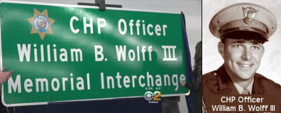 The I-10 interchange with I-605 ( LA
31.151) in the County of Los Angeles is named the "CHP Officer William
B. Wolff III Memorial Interchange". It was named in memory of CHP
Officer William B. Wolff III, who was born in January 1946, in Akron,
Ohio. Officer Wolff graduated from Upper Darby High School in
Philadelphia, Pennsylvania, in 1964, and attended Cal Poly Pomona shortly
thereafter, where he received a degree in kinesiology. Officer Wolff was a
licensed vocational nurse and also served our country as a member of the
United States Navy prior to becoming a California Highway Patrol officer.
Officer Wolff is remembered as a proud father and grandfather. Officer
Wolff, badge number 8342, entered the California Highway Patrol Academy on
August 13, 1973, and, upon graduation, was assigned to the Baldwin Park
area, where he served for approximately five years. Officer Wolff was
killed in the line of duty on December 30, 1977, while making a traffic
stop along the I-10 freeway in Baldwin Park, when he was struck by a drunk
driver. The motorist who killed Officer Wolff was charged with felony
drunk driving. Officer Wolff was a hard working, dedicated officer who
loved his job and enjoyed the people he worked with. He was known for
being a loyal family man and a wonderful father. Named by Assembly
Concurrent Resolution 86, Resolution Chapter 185, on 09/21/15.
The I-10 interchange with I-605 ( LA
31.151) in the County of Los Angeles is named the "CHP Officer William
B. Wolff III Memorial Interchange". It was named in memory of CHP
Officer William B. Wolff III, who was born in January 1946, in Akron,
Ohio. Officer Wolff graduated from Upper Darby High School in
Philadelphia, Pennsylvania, in 1964, and attended Cal Poly Pomona shortly
thereafter, where he received a degree in kinesiology. Officer Wolff was a
licensed vocational nurse and also served our country as a member of the
United States Navy prior to becoming a California Highway Patrol officer.
Officer Wolff is remembered as a proud father and grandfather. Officer
Wolff, badge number 8342, entered the California Highway Patrol Academy on
August 13, 1973, and, upon graduation, was assigned to the Baldwin Park
area, where he served for approximately five years. Officer Wolff was
killed in the line of duty on December 30, 1977, while making a traffic
stop along the I-10 freeway in Baldwin Park, when he was struck by a drunk
driver. The motorist who killed Officer Wolff was charged with felony
drunk driving. Officer Wolff was a hard working, dedicated officer who
loved his job and enjoyed the people he worked with. He was known for
being a loyal family man and a wonderful father. Named by Assembly
Concurrent Resolution 86, Resolution Chapter 185, on 09/21/15.
(Image sources: CBS2, California Assn of Highway Patrolmen)
 The interchange of I-605 and I-210
(~ LA 25.721) is named the Los Angeles County
Deputy Sheriff David W. March Memorial Interchange. It was named in
memory of Deputy David W. March of the Los Angeles County Sheriff's
Department, who was killed in the line of duty at the age of 33 on April
29, 2002, in Irwindale while conducting a "routine" traffic stop. The
suspect, Armando "Chato" Garcia, a Mexican citizen who had previously been
deported multiple times, had told friends that he wanted to kill a police
officer during a traffic stop. The suspect intentionally got stopped and
waited for Deputy March to get in front of his patrol car so he could open
fire, as Deputy March would have no place to take cover. Deputy March was
shot several times in the head and chest. The suspect, who was identified
shortly after the shooting, fled to Mexico where he remained for four
years. On Feb. 23, 2006, the suspect was arrested in Mexico by U.S.
Marshals and Mexican federal agents following a joint investigation. He
was extradited back to California and on March 2, 2007. He plead guilty to
second-degree murder and was sentenced to life in prison without the
possibility of parole. Dep. Sheriff March was a longtime resident of Santa
Clarita Valley and a 1988 graduate of Canyon High School where he played
football and baseball. He served seven years as a law enforcement officer.
It was named by Assembly Concurrent Resolution 142, July 16, 2004. Chapter
122.
The interchange of I-605 and I-210
(~ LA 25.721) is named the Los Angeles County
Deputy Sheriff David W. March Memorial Interchange. It was named in
memory of Deputy David W. March of the Los Angeles County Sheriff's
Department, who was killed in the line of duty at the age of 33 on April
29, 2002, in Irwindale while conducting a "routine" traffic stop. The
suspect, Armando "Chato" Garcia, a Mexican citizen who had previously been
deported multiple times, had told friends that he wanted to kill a police
officer during a traffic stop. The suspect intentionally got stopped and
waited for Deputy March to get in front of his patrol car so he could open
fire, as Deputy March would have no place to take cover. Deputy March was
shot several times in the head and chest. The suspect, who was identified
shortly after the shooting, fled to Mexico where he remained for four
years. On Feb. 23, 2006, the suspect was arrested in Mexico by U.S.
Marshals and Mexican federal agents following a joint investigation. He
was extradited back to California and on March 2, 2007. He plead guilty to
second-degree murder and was sentenced to life in prison without the
possibility of parole. Dep. Sheriff March was a longtime resident of Santa
Clarita Valley and a 1988 graduate of Canyon High School where he played
football and baseball. He served seven years as a law enforcement officer.
It was named by Assembly Concurrent Resolution 142, July 16, 2004. Chapter
122.
(Image source: SCV History)
 Exit Information
 Other WWW Links
 Classified Landcaped Freeway
The following segments are designated as Classified Landscaped Freeway:
| County | Route | Starting PM | Ending PM |
| Orange | 605 | 3.09 | R1.64 |
| Los Angeles | 605 | R0.00 | R8.24 |
| Los Angeles | 605 | R8.28 | R8.47 |
| Los Angeles | 605 | R8.94 | R16.52 |
| Los Angeles | 605 | R16.57 | R17.69 |
| Los Angeles | 605 | R17.75 | R19.45 |
| Los Angeles | 605 | R19.49 | R19.85 |
| Los Angeles | 605 | R20.00 | 21.26 |
| Los Angeles | 605 | 25.61 | 26.00 |
 Interstate Submissions
Approved as chargeable Interstate from Route 405 to Route 10 on 9/15/1955; the Route 10 to Route 210 portion was approved as chargeable in December 1968 as a result of the December 1968 Federal Aid Highway Act.
In November 1957, the California Department of Highways proposed this as I-13. When that was rejected for an urban route, the department tried it as a 3 digit interstate, I-105. This was before the numbering conventions were established, and sequential 3dis were being used. That number was also rejected. In August 1958, the department proposed I-605, which was accepted.
 Freeway
[SHC 253.1] Entire route. Added to the Freeway and Expressway system in 1959.
 Statistics
Overall statistics for I-605:
© 1996-2020 Daniel P. Faigin.
Maintained by: Daniel P. Faigin
<webmaster@cahighways.org>.
 Route 580
 Route 680