
 California Highways:
Click here for a key to the symbols used. An explanation of acronyms may be found at the bottom of the page.
 Routing
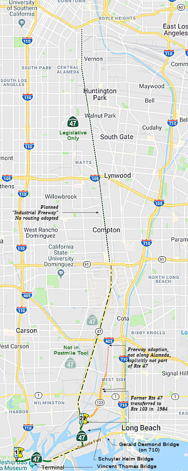 From Route 110 in San Pedro to Route 10 via the Vincent
Thomas Bridge. Route 47 also includes that portion of Henry Ford Avenue
from Route 47 to Alameda Street and that portion of Alameda Street from
Henry Ford Avenue to Route 91, but not that portion of the adopted route
from Route 1 to Willow Street and that portion of the adopted alignment
from Willow Street to Route 405.
From Route 110 in San Pedro to Route 10 via the Vincent
Thomas Bridge. Route 47 also includes that portion of Henry Ford Avenue
from Route 47 to Alameda Street and that portion of Alameda Street from
Henry Ford Avenue to Route 91, but not that portion of the adopted route
from Route 1 to Willow Street and that portion of the adopted alignment
from Willow Street to Route 405.
 Post 1964 Signage History
As defined in 1963, Route 47 ran from "Route 7 (now I-710) at Terminal Island to Route 10.". This was the definition of LRN 270, and was the planned Industrial Freeway. At this time, the defined Route 7 (I-710) curved W along Seaside Drive. A proposed alignment of Route 47 was supposed to split off just north of the drawbridge from Terminal Island.
In 1965, Chapter 1372 added the portion from Route 11 (present-day I-110) to Route 7 (present-day I-710), making the route "Route 11 in San Pedro to Route 10 via the Vincent Thomas Bridge." Note that the reference to Route 7 (Route 710) refers to where that route meets Route 47 at Henry Ford Avenue. The portion of Seaside E of Henry Ford, as well as Ocean Avenue and Harbor Scenic Drive N to Route 1 is part of Route 7 (current Route 710). A 1965 planning map shows Route 47 as freeway its entire length. There were later proposals that extended the Terminal Island Freeway as Route 47 north from its end at Willow Street rather than north of the drawbridge. See the pre-1964 history section for more information on the Vincent Thomas Bridge.
Note that the portion of signed Route 47 from the E end of the Vincent Thomas Bridge approach to Henry Ford does not show as state highway in the state highway database. Also not in the database is the portion N of Route 103. Only the Vincent Thomas Bridge, and the portion along Henry Ford from Route 710 to Route 103, is state highway.
 The freeway routing of Route 47 was adopted by the California Highway Commission on January 22,
1969. The adopted freeway routing of Route 47 absorbed the entirety
of the Terminal Island Freeway (i.e., the portion from Henry Ford to
Willow Street). The "paper" route then ran from Willow to I-10.
The freeway routing of Route 47 was adopted by the California Highway Commission on January 22,
1969. The adopted freeway routing of Route 47 absorbed the entirety
of the Terminal Island Freeway (i.e., the portion from Henry Ford to
Willow Street). The "paper" route then ran from Willow to I-10.
(Source: Gribblenation Blog (Tom Fearer): The Terminal Island Freeway (California State Route 103 and California State Route 47); Image source: Los Angeles Times, 12/11/1969 via Joel Windmiller, 2/19/2023)
By 1975, it was only constructed across the Vincent Thomas Bridge, from the Harbor Freeway (Route 11, now Route 110) and the bridge approach to Seaside (and the bridge approach) and the interchange just E of Mormon St. This makes it clear that the bridge was the real heart of Route 47.
In 1975, the California Highway Commission rescinded the freeway adoption between Route 405 and Route 91. Note that this did not necessarily rescind any surfaces street adopted as the routing; it only rescinded the future freeway routing. The freeway routing was approved on January 22, 1969.
In 1981, Chapter 292 changed Route 11 to refer to Route 110.
In 1982, the language was added to note that Route 47 shall also include that portion of Henry Ford Avenue from Route 47 to Alameda Street and that portion of Alameda Street from Henry Ford Avenue to Route 91, but not that portion of the adopted route from Route 1 to Willow Street and that portion of the adopted alignment from Willow Street to Route 405. Note: The portion of the Terminal Island Freeway N of Route 1 is in the City of Long Beach, not Los Angeles, and the adopted alignment from Willow Street in Long Beach (Sepulveda Blvd on the City of Los Angeles side of the border) to I-405 existed only to connect the Alameda alignment with the Terminal Island Freeway portion N of Willow (and thus became unnecessary when that was dropped). The routing along Alameda Street, however, is not in Long Beach: It is in the City of Los Angeles and the City of Carson.
Although it didn't impact the legislative definition of Route 47, in 1984, Chapter 409 redefined Route 103 as "Route 47 in Long Beach (later corrected to Los Angeles) to Route 1." This was a segment dropped from Route 47 in 1982 (and constituted the original Terminal Island Freeway, constructed by the City of Long Beach in the 1950s). This route was signed as Route 47 after 1964, though the alignment of Route 47 actually splits off about ¼ mi north of the drawbridge from Terminal Island.
In other words, in 1982, Route 47 was switched back to Henry Ford Avenue and Alameda Street, and the remainder became Route 103. This appears to be what the legislative definition refers to when it mentions the adopted alignment ("but not that portion of the adopted route from Route 1 to Willow Street and that portion of the adopted alignment from Willow Street to Route 405"). The mention of the segment from Willow Street / Sepulveda to Route 405 makes one believe that Route 103 originally ran to Route 405. The portion of freeway (now Route 103) from Route 1 to Willow Street /Sepulveda is not state highway anymore.
The portion from Route 1 to Route 10 was the heart of the proposed "Industrial Freeway", and may have been intended to connect up with LRN 222, which would have run from I-5 (US 99) to I-110 (US 66). There would have then been a continuation (not known to be in the state highway system) that ran N to the I-5/Route 2 junction. Although the Terminal Island Freeway was on the drawing board since 1949 (ACSC proposal), the Industrial Freeway didn't show up until the mid-1950s. It appears to have been proposed to run roughly from Santa Fe, angling W to Wilmington, ending up near Central and present-day I-10. In 1963, it was reported that route location studies were initiated at the beginning of the year for the Industrial Freeway. After Route 103 was defined, the routing changed slightly to go from Alameda instead of Santa Fe, still ending up near Central and I-10. Note that a 1957 map shows a connection between Route 47 and Route 7 (I-710). Other maps show a connection to Route 91 near Wilmington.
 Pre 1964 Signage History
The early history of this route is complicated, and tied up with Route 710. It centers around LRN 167, LRN 231, and the future I-710, Route 47 and Route 103.
In 1933, the route from "Long Beach via Atlantic Boulevard to [LRN 26] near Monterey Park" was added to the state highway system. In 1935, it was added to the highway code as LRN 167, with the same routing. Note the starting point of the route is not the Port of Los Angeles -- it is Pacific Coast Highway (US 101A, US 6) in the city of Long Beach. This is what would eventually become Route 710.
 In 1949, Chapter 1261 defined LRN 231 as
“[LRN 165] in San Pedro to [LRN 167] in Long Beach, via the mainland portion of Long Beach Outer Harbor and Terminal Island, subject to the following conditions:
1. Except as provided in paragraph number 2, no expenditure shall be made from state highway funds for the acquisition of rights of way for or construction, improvement, or maintenance of said highway until the following conditions have been met:
(a) The Federal Government shall have made available all funds necessary for the construction of said route, other than funds provided under paragraph 2.
(b) The Federal Government and the Cities of Los Angeles and Long Beach shall have granted a sufficient and adequate right of way without cost to the State of California for that portion of said route traversing lands owned or controlled by each of them.
(c) The authorized representatives of the Cities of Los Angeles and Long Beach and the appropriate agency of the Federal Government shall have approved the proposed alignment and the proposed location of all major structures on the route submitted by the State Department of Public Works.
2. Any city or county may contribute to, and the California Highway Commission may allocate monies from the State Highway Fund for the improvement of portions of [LRN 231] on the mainland when such improvement is found necessary to complete and integrated system of freeways between San Pedro, Long Beach, and the Civic Center in the City of Los Angeles.
3. If funds from sources other than state highway funds have not been made available for the construction on all portions of said [LRN 231] that are not on the mainland prior to January 15, 1953, said [LRN 231] shall on that date cease to be a state highway and this section shall have no further force or effect. ”
LRN 231 referred to a proposal for a potential toll highway that would
include two channel crossings from San Pedro to Terminal Island (what
eventually became the Vincent Thomas Bridge), and from Terminal Island to
Long Beach (replacing the pontoon bridge -- what became the Gerald Desmond
bridge). These were planned to be tube crossings, with the San
Pedro-Terminal Island tube estimated at $10 million. The other tube had a
similar estimate, but financing was not possible at the time. The route
also incorporated the Federally-constructed Terminal Island Freeway, and
extended it from Willow Blvd to the Los Angeles River Freeway (LRN 167,
former Route 15, current I-710). The definition of LRN 231 required the
government to come up with the funds, and so LRN 231 disappeared in 1953.
(Source: 1956 Report to the California Toll Bridge Authority on a Proposed Toll Highway Crossing of Los Angeles Harbor from San Pedro to Terminal Island)
That said, there was still the Terminal Island Freeway. The initial segment of the route ran from Henry Ford Avenue to Willow St, and also include the portion of Henry Ford from Seaside. But this wasn't originally part of the state highway system. The segment from Seaside Blvd to Willow St. (3.1 mi) was designed by the State Division of Highways and constructed under State and US Navy contracts, and financed by the US Navy and Federal Aid Funds for $12 million. The State Division of Highways was reimbursed in full for its services. At one point, this was called the "Seaside Freeway".
In 1957, Chapter 1911 extended the origin of LRN 167 to [LRN 165] (Harbor
Freeway): “[LRN 165] in San Pedro Long Beach
to Huntington Drive via Long Beach”. This incorporated
Seaside Blvd, and provided a different route for the connection betwen LRN 165 and LRN 167 from the deleted LRN 231 routing. This created the routing
for future Route 7/I-710 to San Pedro instead of Long Beach. But as one
can see from the map, the routing wasn't quite the current routing yet.
In 1958, Chapter 74 added the San Pedro-Terminal Island Bridge to LRN 167: "[LRN 165] in San Pedro to Huntington Drive via Long Beach, and including a bridge with at least four lanes from San Pedro at or near Boschke Slough to Terminal Island". See below for more information on the bridge, which was eventually named the Vincent Thomas Bridge. The recommendation for the bridge was likely a consequence of the cost of the tube.
In 1959, Chapter 1062 defined LRN 270 as “Terminal Island to [LRN 173]”. This was the proposed "Industrial" Freeway, which ran from LRN 167 to I-10. This eventually would become the portion of Route 47 along Henry Ford Avenue.
By 1960, the routing in the port had assumed the current approach running to Route 47 (portions of which were LRN 167 across the Vincent Thomas Bridge). Setting aside the Seaside Freeway portion, this was LRN 270 between Seaside Blvd (Route 47/Route 103 junction) and the future I-10 (LRN 173). The LRN 167 portion (between Long Beach and San Pedro) was a 1957 extension of LRN 167; the LRN 270 portion was defined in 1959.
Sign Route 47 was not allocated as part of the initial state signage of routes in 1934. It is unclear if any route was signed as Sign Route 47 before 1964.
Vincent Thomas Bridge ( (~ LA 1.334 to LA 1.683)
") Before 1957, when LRN 167 was extended to the Harbor
Freeway (LRN 165), ferry service was the only means of transport across
the Terminal Island channel for decades. Beginning in 1870, private
ferry service provided carried travelers between the two locations.
In 1941 the Municipal Ferry Service provided regularly scheduled services
for passengers and vehicles between Terminal Island and San Pedro aboard
its double decked ferries, “Islander” and
“Ace”. In November 1963, ferry services were ceased when
the Vincent Thomas Bridge was opened.
Before 1957, when LRN 167 was extended to the Harbor
Freeway (LRN 165), ferry service was the only means of transport across
the Terminal Island channel for decades. Beginning in 1870, private
ferry service provided carried travelers between the two locations.
In 1941 the Municipal Ferry Service provided regularly scheduled services
for passengers and vehicles between Terminal Island and San Pedro aboard
its double decked ferries, “Islander” and
“Ace”. In November 1963, ferry services were ceased when
the Vincent Thomas Bridge was opened.
(Source: Palos Verdes Pulse, 8/8/2020; Image source: Wikimedia Commons - Original photo © 2009 Chris Valle per Wikimedia
licensed and shared via Creative Commons)
From 1937 until 1957, various proposals were considered regarding construction of a tube tunnel connecting the Harbor and Long Beach freeways. Engineers concluded that a four-lane bridge could be built for slightly more than the two-lane tube.
The proposed Terminal Island Bridge appeared as a
concept drawing in the May/June 1959 California Highways & Public
Works. The article noted the California Highway Commision on April
30, 1959, decided to fund the Terminal Island Bridge as a tolled
facility. The Terminal Island Bridge project area was described as
being approximately 7,400 feet, and was to be constructed a short distance
north of the Terminal Island Ferry route in San Pedro at the planned
Harbor Freeway extension. It would tie into Seaside Avenue on
Terminal Island near Mormon Street. In 1959, the Terminal Island Bridge
was adopted as part of a 1.6-mile freeway by the California Highway
Commission. A groundbreaking ceremony commencing construction of the
Terminal Island Bridge took place on May 28, 1960.
(Source: Gribblenation Blog (Tom Fearer), “California State Route 47 and the Vincent Thomas Bridge”, April 2022)
Completed in 1963, the San Pedro-Terminal Island
Bridge, renamed the Vincent Thomas Bridge in 1961, was the first bridge of
its kind to be constructed from 990 steel poles, known as piles, that were
hammered into the soil until they reached a layer of hard compacted soil
or rock. Construction required 92,000 tons of Portland cement, 13,000 tons
of lightweight concrete, 14,100 tons of steel and 1,270 tons of suspension
cable. This was the first welded suspension bridge built in the U.S. and
can withstand 90 mph winds, double that required by code. The overall
length of the bridge is 6,050 feet, with a main suspension span of 1,500
feet and 500-foot spans on either side. The towers are 365 feet high. The
entire construction bill totaled $21 million. The Vincent Thomas Bridge
was determined eligible for inclusion in the National Register of Historic
Places as part of the Caltrans Historic Bridge Inventory Update of 2010.
The bridge is eligible for engineering significance. In addition to being
a rare bridge type of "exceptional span length, monumental scale and
design complexity," it is the first suspension bridge in the United States
not to use rivets in its construction.
(Source: San Pedro.Com — Vincent Thomas Bridge, May 2021; Bridgehunter, May 2021; Palos Verdes Pulse, 8/8/2020)
In 1968, the bridge was connected into the Harbor Freeway.
Originally, a $0.25 toll was assessed for each
westbound and eastbound vehicle. In 1983, a $0.50 toll was assessed
to westbound bound traffic only. The toll charge was discontinued in
2000. The Toll Plaza now serves as a field facility for the
California Highway Patrol. The toll was initiated when the bridge opened
Nov. 15, 1963, to pay off a $26-million construction bill. Only $6.2
million was owed by 1999, and $14 million was in the bridge’s
reserves.
(Source: Los Angeles Times, 11/26/1999; Palos Verdes Pulse, 8/8/2020)
As plans were made to open the bridge, the California
legislature passed special legislation to name the bridge after California
Assembly Member, Vincent Thomas. Assembly Member Mr. Thomas began
his term in the California Assembly in 1940 representing the City of San
Pedro and surrounding area. At the time of the legislation, he was
the longest serving member of the Assembly and had supported over 16
different pieces of legislation supporting the bridge’s
construction. Assembly Member Thomas left the Assembly after serving
19 Assembly terms for a total of 38 years in 1978.
(Source: Palos Verdes Pulse, 8/8/2020)
After the 1989 Loma Prieta earthquake, Caltrans began
an extensive, multibillion-dollar retrofitting of all toll bridges in the
state. The Vincent Thomas was one of the first completed, in March 2000.
The $8 million left in the bridge’s reserves was applied to paying
for the retrofitting.
(Source: Los Angeles Times, 11/26/1999)
The bridge is repainted regularly. A cycle takes 12
years and is begun anew as soon as it is finished. The bridge was pained
bright green when it opened and remained that way until 1983. In 1999,
after 16 years of coating the bridge with a plain green, the painters will
restore the span to its original iridescent green glory. The bright color
was dropped in 1983 because the paint released a residue that was not
environmentally sound. But paint technology has since advanced, and the
iridescent shade is now safe.
(Source: Los Angeles Times, 11/26/1999)
In celebration of its 25th anniversary in 1988, a
fundraiser project provided $170,000 to install decorative lights on the
bridge’s main cables. In 2004, after 17 years of planning and
fundraising, the bridge was modified to add blue LED lighting. In January
2005, the Vincent Thomas Bridge Lighting ceremony was held. The bridge is
illuminated with blue LED lights that are powered by solar panels. The
solar panels feed more electricity into the grid during the day than the
LED lights use at night. There are 160 lights on the bridge and it is the
first combined use of solar power and LEDs in a bridge lighting
installation. The lights operate from dusk to midnight in order to
minimize impact on wildlife.
(Source: San Pedro.Com — Vincent Thomas Bridge, May 2021)
The dramatic green bridge is designated as the official
landmark welcoming visitors to Los Angeles.
(Source: Palos Verdes Pulse, 8/8/2020; San Pedro.Com — Vincent Thomas Bridge, May 2021)
 Status
 The portion between Route 110 to Route 103 and from Route 103
to Route 10 is unconstructed as freeway. Sections from Route 103 to Route 91 are part of the Los Angeles demonstration project. The state will
assume maintenance when the route is brought up to standards, which
includes adequate widening.
The portion between Route 110 to Route 103 and from Route 103
to Route 10 is unconstructed as freeway. Sections from Route 103 to Route 91 are part of the Los Angeles demonstration project. The state will
assume maintenance when the route is brought up to standards, which
includes adequate widening.
According to the 2013 Traversable Highways report, the segment from the
Vincent Thomas Bridge to Route 103 are to be improved. When this segment
is improved, it will be considered for assumption of
maintenance. Projects are under construction. For the segment from Route 103 to Route 91, a new controlled access facility is planned for this
segment (but I'll believe that when I see that, as I've seen nothing new
since 2013).
Note: For information on the Gerald Desmond Bridge or the Shoemaker Bridge, see Route 710.
Route 47/I-110 Connector (~ LA R0.076)
In August 2012, the CTC approved for future consideration of funding a project that will widen the Route 47/I-110 connector from one to two lanes (~ LA R0.076), extend the additional through lane on the northbound I-110 past the John S. Gibson Boulevard off-ramp, modify the northbound ramps at the I-110/John S. Gibson Boulevard interchange, and improve the intersection of John S. Gibson Boulevard and the northbound I-110 ramps. The project is programmed in the Trade Corridor Improvement Fund. The total estimated cost is $39,068,000 for capital and support. Construction is estimated to begin in Fiscal Year 2012-13. The scope, as described for the preferred alternative, is consistent with the project scope programmed in the Trade Corridor Improvement Fund.
The SAFETEA-LU act, enacted in August 2005 as the reauthorization of TEA-21, provided the following expenditures on or near this route:
In March 2021, it was reported that a design to revamp
the busy San Pedro interchange from Route 110 onto the Vincent Thomas
Bridge and Harbor Boulevard has been delayed after soft, clay-like soil
was discovered on part of the property. The soil can settle up to 26
inches, requiring additional work on the site for drainage, landscaping
and retaining wall support, according to a staff report to a March 2021
Los Angeles Board of Harbor Commissioners meeting. It will cost an
additional $1.9 million. The project, near Knoll Hill, was initially
slated to be completed in 2023, but now that will be pushed back to
December 2025, at the latest, due to the extra work, port officials said
during the board meeting. The finished designs should be ready by the end
of this year, with construction starting in November 2022. Under this
plan, the existing Harbor Boulevard offramp that takes cars and trucks off
the southbound Harbor Freeway will be widened with a second dedicated
right-hand lane, leaving one lane to take traffic straight across Harbor
Boulevard and onto Swinford Street. The changes also will assist truck
traffic using port terminals in the northern part of the Main Channel.
Safety and congestion issues have plagued the spot where the southbound
I-110 peels off onto a connector road for the Vincent Thomas Bridge and
the adjacent offramp that takes traffic to Harbor Boulevard. Jockeying to
merge has resulted in weaving as traffic approaches the intersection,
according to the staff report, and vehicles typically back up onto both
off-ramps during peak times. The now-delayed plan will reconfigure the
interchange of State Route 47 and Harbor Boulevard as a way to cut down
the backed-up traffic.
(Source: Daily Breeze, 3/5/2021)
State Route 47/Vincent Thomas Bridge and Front Street/Harbor Boulevard Interchange Reconfiguration Project (07-LA-47, PM 0.3/0.8)
In May 2023, the CTC approved for future consideration
of funding the following project for which a ND and an Addendum has
been completed: Route 47 in Los Angeles County (07-LA-47, PM 0.3/0.8).
Modify the existing onramps and offramps to improve safety, access, and
the efficient operation of Route 47/Front Street/Harbor Boulevard
Interchange, in Los Angeles County. (PPNO 5088) This project is located on
Route 47 from postmile 0.3 to postmile 0.8, in Los Angeles County. The
Department proposes to modify the existing onramps and offramps to improve
safety, access, and the efficient operation of Route 47/Front
Street/Harbor Boulevard Interchange. The project is currently programmed
in the 2020 State Transportation Improvement Program (STIP) for a total of
$70,500,000, which includes $13,383,000 in Senate Bill 1 Trade Corridor
Enhancement Program Funds. Construction is estimated to begin 2020-21. The
scope, as described for the preferred alternative, is consistent with the
project scope as programmed by the Commission in the 2020 STIP.
(Source: May 2023 CTC Agenda, Agenda Item 2.2c.(1))
In May 2023, the CTC approved the following CONST
allocation for the following locally-administered TCEP project:
$13,383,000. 07-LA-47 0.3/0.8. PPNO 07-5088; ProjId 0715000304, EA 4CONL.
State Route 47-Vincent Thomas Bridge and Harbor Boulevard-Front Street
Interchange Improvement Project. The project entails modifying the
existing on- and off-ramps to improve safety, access, and the efficient
operation of the Route 47 / Front Street / Harbor Boulevard Interchange.
CEQA - ND, 09/28/2018; Re-validation 08/01/2022 NEPA - FONSI, 09/28/2018;
Re-validation 08/01/2022. Right of Way Certification: 03/15/2023
Contribution from other sources: $79,592,000. Concurrent consideration of
funding approved under Resolution E-23-59; May 2023. Time extension for FY
21-22 CONST expires June 30,2023. CONST $13,383,000.
(Source: May 2023 CTC Agenda, Agenda Item 2.5s.(7))
Vincent Thomas Bridge (R0.4/2.0)
The SAFETEA-LU act, enacted in August 2005 as the reauthorization of TEA-21, provided the following expenditures on or near this route:
Opened in 1963, the distinctive — and much loved
— emerald green suspension bridge was part of the focus of a 2003
traffic congestion study commissioned by the Port of Los Angeles. The
primary problems, according to agency information gathered and provided by
Caltrans District 7, are twofold: a deterioration of the deck due to
saltwater and moisture on the structural steel. To address this, a
permanent crew of 10 bridge painters maintains the coating of the
structural steel full-time. The 2003 report by Meyer, Mohaddes Associates
Inc. concluded that the bridge could reach its capacity as early as 2010
in light of the growing port traffic. “A range of alternatives must
be evaluated,” the report said, “including
modification/upgrade of the Vincent Thomas Bridge, replacement of the
bridge with a facility with greater capacity, (or) other network
improvements.” A later port traffic study also looked at some bridge
possibilities on the table, including adding a second bridge that could
run parallel to the Vincent Thomas. Building an adjacent bridge would,
according to the information Caltrans gathered, be the only way to
“widen” the bridge. A more recent study mostly examined ways
to improve the existing structure by improving transition roads and on-
and off-ramps serving the bridge as the more practical way to ease
gridlock. Recent improvements have been made — including adding a
lane at the busy transition nexus between the bridge and Route 110 north
— that have eased the congestion on the bridge. Another plan is to
reconfigure the interchange of Route 47 and Harbor Boulevard. That will be
aimed at cutting down the backed-up traffic on off-ramps during peak
hours, a situation that’s expected to get worse with growing
traffic. The project was is in an environmental study stage in 2020, and
is expected to go out to bid in 2022. The Vincent Thomas is considered
small by today’s bridge engineering standards. It’s up to date
with seismic improvements made in 2018, although an accident or stalled
vehicle can still cause a major and lengthy backup on the two-lane
roadway.
(Source: Press Telegram, 10/2/2020)
In January 2023, the CTC added the following SB1
project into the 2022 SHOPP: (1b) #1. 07-LA-47 R0.4/2.0. PPNO 07-6024;
ProjID 0722000334; EA 39020. Route 47 In the city of Los Angeles, near the
Port of Long Beach, at Vincent Thomas Bridge № 53-1471. Replace
bridge deck and seismic sensors. Allocation ($ × 1,000): PA&ED
$17,140; PS&E $20,900; R/W Sup $17; Con Sup $39,840; R/W Cap $30;
Const Cap $628,464; TOTAL $706,391. FY25-26. Concurrent COS allocation
under Resolution FP-22-45; January 2023. SB1 Baseline Agreement Required.
Begin Const: 12/24/2025.
(Source: January 2023 CTC Agenda, Agenda Item 2.1a.(1b) #1)
In January 2023, the CTC approved SB1 pre-construction
project phase allocation of $17,140,000. 07-LA-47 R0.4/2.0. PPNO 07-6024;
ProjID 0722000334; EA 39020. Route 47 In the city of Los Angeles, near the
Port of Long Beach, at Vincent Thomas Bridge № 53-1471. Replace
bridge deck and seismic sensors. Concurrent Amendment under SHOPP
Amendment 22H-006; January 2023. PA&ED $17,140,000.
(Source: January 2023 CTC Agenda, Agenda Item 2.5b.(2b) #6)
 In May 2023, it was reported that Caltrans was holding
public meetings on the Vincent Thomas Bridge reconstruction. Construction
isn’t expected to start until 2025, but significant preparation is
required for the project, which will close or reduce lanes on the Vincent
Thomas Bridge for nine months or longer. The historic 6,000-foot span is
the only way to access Terminal Island and the Port of Long Beach from the
west, and the 60-year-old suspension bridge needs a full deck replacement.
The potential detour routes would have the biggest impact on Wilmington,
but some traffic caused by the construction would likely spill into Long
Beach. Three options for the project are on the table, and Caltrans
is gathering feedback to inform the choice: (1) Closing the entire
four-lane bridge for nine to 12 months and working day and night until
it’s done; (2) Keeping one lane open during the day, with full
closure on nights and weekends for one and a half to two years; (3)
Opening one lane in each direction with night and weekend closures for two
to two and a half years. The latter two choices could also be done without
the 55-hour weekend closures, adding about six months to the project. The
Vincent Thomas Bridge is being overhauled rather than replaced because
it’s registered as a state historical resource, and while the bridge
that replaced Gerald Desmond was raised to give clearance to larger ships,
Vincent Thomas is already 30 feet higher than the old Gerald Desmond. It
cost taxpayers $1.56 billion to build the totally new replacement bridge
for the Gerald Desmond, whereas putting down a new deck and bringing the
railings, center median and other features up to current safety standards
for the Vincent Thomas is projected to cost about $706 million. After the
public comment period ends in early Summer 2023, as required by state law,
the project will undergo technical studies, and by the end of the year
Caltrans will circulate a draft environmental impact report before holding
another public meeting to gather more feedback. Studies will continue into
2024, with more public comments included in the report and a final version
expected to be released by Spring 2025, according to Caltrans.
In May 2023, it was reported that Caltrans was holding
public meetings on the Vincent Thomas Bridge reconstruction. Construction
isn’t expected to start until 2025, but significant preparation is
required for the project, which will close or reduce lanes on the Vincent
Thomas Bridge for nine months or longer. The historic 6,000-foot span is
the only way to access Terminal Island and the Port of Long Beach from the
west, and the 60-year-old suspension bridge needs a full deck replacement.
The potential detour routes would have the biggest impact on Wilmington,
but some traffic caused by the construction would likely spill into Long
Beach. Three options for the project are on the table, and Caltrans
is gathering feedback to inform the choice: (1) Closing the entire
four-lane bridge for nine to 12 months and working day and night until
it’s done; (2) Keeping one lane open during the day, with full
closure on nights and weekends for one and a half to two years; (3)
Opening one lane in each direction with night and weekend closures for two
to two and a half years. The latter two choices could also be done without
the 55-hour weekend closures, adding about six months to the project. The
Vincent Thomas Bridge is being overhauled rather than replaced because
it’s registered as a state historical resource, and while the bridge
that replaced Gerald Desmond was raised to give clearance to larger ships,
Vincent Thomas is already 30 feet higher than the old Gerald Desmond. It
cost taxpayers $1.56 billion to build the totally new replacement bridge
for the Gerald Desmond, whereas putting down a new deck and bringing the
railings, center median and other features up to current safety standards
for the Vincent Thomas is projected to cost about $706 million. After the
public comment period ends in early Summer 2023, as required by state law,
the project will undergo technical studies, and by the end of the year
Caltrans will circulate a draft environmental impact report before holding
another public meeting to gather more feedback. Studies will continue into
2024, with more public comments included in the report and a final version
expected to be released by Spring 2025, according to Caltrans.
(Source: Long Beach Post News, 5/17/2023; Image source: Caltrans via LBPN)
In July 2023, it was reported that there is significant
opposition to this: less so for the project itself, and more related to
the impact that the closures and reroutings from the construction effort
will have on traffic in the neighborhood. For example, one Wilmington
resident commented on the high volume of truck traffic that goes through
Wilmington on a daily basis is already a big concern, especially on
Anaheim and Pacific Coast Highway. Caltrans’ proposed alternate
routes would bring more truck traffic and the pollution that comes with
it. It was noted that some of the streets in Wilmington are already
dangerous, not just from heavy traffic, but also from poorly maintained
roads. The Caltrans advisory committees have noted that the most
common feedback they’ve received is concerns about the impact on
traffic. The project won’t start construction until 2025, but there
is incentive to do it quickly. One of the funding condistion is that they
have to deliver the project and open the construction by a certain time.
(Source: Random Length News, 7/20/2023)
Under Traffic Congestion Relief Program Project #44, there are plans to construct a grade-separated interchange at Ocean Boulevard and the Terminal Island Freeway (~ LA 3.691), and at Ocean Boulevard and Henry Ford Avenue, including the preparation of plans and specifications, estimates, and related support activities for design and construction. (January 2001 CTC Agenda, Agenda Item 2.1c.(1), project 44; Negative Impact EIR Report, March 2001 CTC Agenda Item 2.2c.(2)). This is currently scheduled for completion in February 2007.
The SAFETEA-LU act, enacted in August 2005 as the reauthorization of TEA-21, provided the following expenditures on or near this route:
Schuyler Heim Bridge Replacement and State Route 47 Expressway Project (07-LA-47, PM 2.7/5.8)
The Commodore Schuyler F. Heim Bridge (Schuyler Heim
Bridge) crosses the Cerritos Channel in the Port of Long Beach, was
commissioned by the United States Navy between 1946 and 1948, and is one
of three bridges that connect Terminal Island to the mainland. The bridge
was named for Commodore Schuyler F. Heim, commanding officer of the
Terminal Island Naval Base throughout World War II. The United States Navy
completed construction of the bridge in 1948 and then turned it over to
the City of Long Beach, which operated the bridge until 1974. The bridge
is a vertical lift structure with a 73-meter (m) (240-foot [ft]) span. It
has an 820-ton movable (lift) span that is supported by two crossbraced
steel towers suspended by cables, and a pair of 400+-ton counterweights.
Historic records indicate that, by 1951, the Schuyler Heim Bridge showed
significant settlement caused by oil extraction in Long Beach Harbor. In
1951, the towers were leaning approximately 3.8 centimeters (cm) (1.5
inches [in]) to the east, and the approach structures had settled as much
as 10.2 cm (4.0 in). The combined effects of settlement and leaning
created the potential to bind the moveable parts and cause the lift span
to fail. Subsequently, the towers were straightened, and additional work
was conducted on the approaches, truss bearings, guard rails, pier
footings, and lift span guide rollers. During the 1950s, the City of Long
Beach pumped groundwater into depleted oil fields beneath the harbor,
which mitigated the bridge’s rate of subsidence. However, the harbor
continued to sink, requiring bridge repairs. By the end of the decade, the
shifting terrain beneath the bridge foundations had caused cracks in the
reinforced concrete pillars beneath the bridge, requiring additional
repairs. Throughout the 1960s, 1970s, and 1980s, bridge repairs continued
for routine maintenance, as well as for damage caused by trucks and marine
vessels. In 1987, the Whittier Narrows earthquake (Richter magnitude [M]
5.9) twisted a heavy girder in one of the towers. In 1988, Caltrans
initiated a $2 million project to refurbish the bridge to accommodate
increased vehicular and marine traffic in response to expansion of the
ports. After the 1994 Northridge earthquake, the Schuyler Heim Bridge was
determined to be in need of seismic retrofit improvements. A Project Scope
Summary Report (PSSR) was completed in 1998 to program the retrofit
project and included the plans, specifications, and engineering estimate
(PS&E) for the retrofit. During the PS&E phase, it was determined
that replacement of the bridge would be more cost-effective and practical
than retrofitting the existing bridge to meet seismic requirements for a
major earthquake. Therefore, the retrofit design was halted. Subsequently,
in consultation with the U.S. Coast Guard, Caltrans developed several
fixedspan bridge alternatives. These alternatives met the project purpose
of complying with the 1994 state mandate for Caltrans to strengthen its
bridges, and met the need to comply with seismic requirements, reduce
potential safety hazards to vehicular and marine traffic, and provide a
cost-effective solution to the ongoing deterioration of the bridge.
(Source: Route 47 EIR)
![[Map]](maps/047-bridge.jpg) Additionally, Caltrans has historically wanted
an expressway in this area, as part of a series of regional transportation
improvements at the southern end of the Alameda Corridor. The Route 47
Expressway is cited in the Southern California Association of Governments
Regional Transportation Plan. It would build upon a network of local
streets by constructing a high-capacity expressway connecting the Ocean
Boulevard/Route 47 Interchange with Alameda Street at Pacific Coast
Highway, thereby providing a missing link in the local transportation
system. The existing Route 47 extends east from the southern terminus of
the Harbor Freeway (I-110) in San Pedro, over the Vincent Thomas Bridge,
along Seaside Avenue and Ocean Boulevard, then north across the Cerritos
Channel on the Schuyler Heim Bridge, continuing north on Henry Ford
Avenue, then onto Alameda Street until its terminus at I-10 in downtown
Los Angeles. The Route 103 Expressway is an alternative to the Route 47
Expressway. It also would build upon a network of local streets by
constructing a high-capacity expressway that connects existing Route 103,
beginning about 0.8 kilometer (km) (0.5 mile [mi]) north of Pacific Coast
Highway, to Alameda Street at a point about 0.8 km (0.5 mi) south of the
San Diego Freeway (I-405). Currently, to connect from Terminal Island to
Alameda Street, vehicles must travel 1.5 km (0.9 mi) north from Ocean
Boulevard, then exit at the Henry Ford Avenue off-ramp and travel north
through local streets, signalized intersections, and railroad crossings
for about 2.0 km (1.2 mi) before joining Alameda Street just south of
Pacific Coast Highway. Alameda Street continues north of Pacific Coast
Highway for 4.0 km (2.5 mi) and connects to the I-405. About 5.5 km (3.4
mi) north of I-405, Alameda Street connects to the Artesia Freeway (Route 91). The existing Route 103 begins north of the Schuyler Heim Bridge at
the Terminal Island Freeway, where Route 47 exits at Henry Ford Avenue.
Route 103 continues north to Pacific Coast Highway, where it ends. The
Terminal Island Freeway continues past the terminus of Route 103 and ends
at Willow Street/Sepulveda Boulevard.
Additionally, Caltrans has historically wanted
an expressway in this area, as part of a series of regional transportation
improvements at the southern end of the Alameda Corridor. The Route 47
Expressway is cited in the Southern California Association of Governments
Regional Transportation Plan. It would build upon a network of local
streets by constructing a high-capacity expressway connecting the Ocean
Boulevard/Route 47 Interchange with Alameda Street at Pacific Coast
Highway, thereby providing a missing link in the local transportation
system. The existing Route 47 extends east from the southern terminus of
the Harbor Freeway (I-110) in San Pedro, over the Vincent Thomas Bridge,
along Seaside Avenue and Ocean Boulevard, then north across the Cerritos
Channel on the Schuyler Heim Bridge, continuing north on Henry Ford
Avenue, then onto Alameda Street until its terminus at I-10 in downtown
Los Angeles. The Route 103 Expressway is an alternative to the Route 47
Expressway. It also would build upon a network of local streets by
constructing a high-capacity expressway that connects existing Route 103,
beginning about 0.8 kilometer (km) (0.5 mile [mi]) north of Pacific Coast
Highway, to Alameda Street at a point about 0.8 km (0.5 mi) south of the
San Diego Freeway (I-405). Currently, to connect from Terminal Island to
Alameda Street, vehicles must travel 1.5 km (0.9 mi) north from Ocean
Boulevard, then exit at the Henry Ford Avenue off-ramp and travel north
through local streets, signalized intersections, and railroad crossings
for about 2.0 km (1.2 mi) before joining Alameda Street just south of
Pacific Coast Highway. Alameda Street continues north of Pacific Coast
Highway for 4.0 km (2.5 mi) and connects to the I-405. About 5.5 km (3.4
mi) north of I-405, Alameda Street connects to the Artesia Freeway (Route 91). The existing Route 103 begins north of the Schuyler Heim Bridge at
the Terminal Island Freeway, where Route 47 exits at Henry Ford Avenue.
Route 103 continues north to Pacific Coast Highway, where it ends. The
Terminal Island Freeway continues past the terminus of Route 103 and ends
at Willow Street/Sepulveda Boulevard.
(source)
As a result, Caltrans initiated a $351 million project to start in 2009 with the following goals:
There are a number of alternatives under consideration:
Alternatives that were eliminated included extending Route 103 to I-405 or I-710, with freeway-to-freeway connections. These were just too expensive.
 As of April 2008, Caltrans
approved replacement of the Schuyler Heim and Gerald Desmond bridges. In
March 2009, the CTC received notice of the draft EIR. In October 2009, the
CTC approved the project for future consideration of finding, based on the
final EIR.
As of April 2008, Caltrans
approved replacement of the Schuyler Heim and Gerald Desmond bridges. In
March 2009, the CTC received notice of the draft EIR. In October 2009, the
CTC approved the project for future consideration of finding, based on the
final EIR.
In July 2010, the CTC approved amending the Proposition 1B Project Baseline Amendment for TCIF Project 16, Route 47 Port Access Expressway and Schuyler Heim Bridge Replacement to split the project into two segments. Segment 1 is for the replacement of the Schuyler Heim Bridge and Segment 2 is for the Route 47 Expressway. The split will allow Segment 1, the Schuyler Heim Bridge replacement, to begin construction in June 2011, while the Environmental Impact Report (EIR) and Environmental Impact Statement (EIS) for Segment 2 are litigated. In Segment 1, the existing lift bridge will be replaced by a fixed span structure, either cast in place or precast concrete. In Segment 2, an expressway (Route 47) will be constructed as an elevated viaduct between Route 103 over Henry Ford Avenue and Alameda Street, where it transitions down to the existing grade south of Route 1.
In March 2016, it was reported that the eastern side of
the new bridge replacing the old Schuyler Heim Lift Bridge is open and
both north and southbound traffic is being routed on it while the old lift
bridge is demolished and the western side of the new bridge is built. New
signage installed for northbound traffic on the Terminal Island Freeway
crossing the new bridge indicates that Route 47 exits off itself as
“Exit 5” at Henry Ford Avenue. Exit 5 is an exit number for
Route 47, as Route 103, which begins as a short concurrency with Route 47
at the Seaside Freeway interchange, begins only 1½ miles south of
this point. The old Schuyler Heim vertical-lift bridge that opened on Jan.
10, 1948, is, piece by piece, now being relegated to port history, deemed
structurally obsolete and seismically unsafe, no longer able to handle the
growing traffic demand or provide the vertical clearance needed for
passing ships. In its place, the California Department of Transportation
is building a $180 million six-lane, fixed-span concrete bridge straight
across and over the Cerritos Channel shipping lane. Rising nearly five
stories above the water, the new bridge will provide plenty of vertical
room. The new three-quarter-mile-long bridge — expected to be
finished in early 2017 — will be safer and reduce maintenance costs,
according to Caltrans. It will allow traffic to move from Terminal Island
directly onto Alameda Street, bypassing three stop lights and five
railroad crossings, according to an article on the Port of Los Angeles
website.
(Source: Occidental Tourist/Andy3175 @ AAroads, Jan/Feb. 2016)
In December 2016, the CTC approved the following allocation: 07-LA-47 2.7/5.8 Route 47 in the cities of Long Beach and Los Angeles from Ocean Boulevard to transition of Route 103 and Henry Ford Avenue along Route 47. Replace Schuyler Heim Bridge Outcome/Output: Supplemental funds are needed to Complete Construction. Total revised amount $24,900,000.
In June 2023, the CTC approved for future consideration
of funding 07-LA-47, PM 2.7/5.8. Schuyler Heim Bridge Replacement and
State Route 47 Expressway Project. Replace the vehicular
connection along the north-south corridor between Terminal Island and the
mainland with a seismically safe bridge and provide a high-capacity
alternative route to and from Terminal Island to improve safety, traffic
movement, and reduce traffic delays, in Los Angeles County. (FEIR
Addendum) (PPNO 0444E) (SHOPP). The project is located on Route 47 from
postmile 2.7 to postmile 5.8, in Los Angeles County. The Department
proposes to construct a four-lane elevated expressway connecting Terminal
Island to Alameda Street, including the replacement of Schuyler Heim
Bridge (Note: This is odd, as the Schuyler
Heim Bridge was just replaced in 2016, but it is possible this is just
Segment 2 of the original proposal). The project is currently
programmed in the 2018 SHOPP for a total of $7,138,000, which includes
Right of Way (Support and Capital) and Construction (Support and Capital).
Construction is estimated to begin 2021-22. The scope, as described for
the preferred alternative, is consistent with the project scope as
programmed by the Commission in the 2018 SHOPP. A copy of the FEIR has
been provided to Commission staff. The Commission approved the project for
future consideration of funding on October 14, 2009, under Resolution
E-09-79. Since the approval of the 2009 FEIR, Addendums were prepared to
describe that the project would be built in phases. Modifications to the
scope include, but are not limited to, the placement of riprap (rock),
placement of soil fill for drainage purposes, minor widening and
modifications to the Henry Ford off-ramp, and the addition of a pumping
station to be completed as a separate phase of construction. The
Department subsequently completed Addendums to the FEIR pursuant to CEQA.
The Department has approved this project for construction. This approval
and Addendums will satisfy the environmental requirements for this stage
of the planning process.
(Source: June 2023 CTC Agenda, Agenda Item 2.2c.(2) Item 7)
According to Daniel Thomas in May 2004, there are trailblazer signs posted at least three times on Alameda Street North at Carson Street, Del Amo Boulevard and Santa Fe Avenue. There were some southbound as well. This is the section that was reconstructed. There were not any signs posted south of I-405, nor along Henry Ford Avenue, although there is a lot of construction happening on that section.
 Statistics
Overall statistics for Route 47:
 Naming
The portion of this route from Seaside Blvd in San Pedro to Sepulveda Blvd. in Long Beach is the "Seaside Freeway". It was named by House Resolution 144 in 1959.
Some Caltrans District VII information shows this as the "Terminal Island Freeway". The first segment opened in 1948. Terminal Island was originally named "Isla Raza de Buena Gente" (Island of the Race of Good People). Early in the American era, the island became known as Rattlesnake Island. In 1911, after the Los Angeles Terminal Railway had built a line from the city to the island, it assumed its present name. Generally, the Terminal Island Freeway is really Route 103.
The proposed name for the planned freeway segment between Route 1 and I-10 was the "Industrial" Freeway.
 Named Structures
 Bridge 53-1471 in San Pedro (LA 000.86) was originally called the "San Pedro-Terminal Island Bridge". It
was built in 1961. It was renamed the "Vincent Thomas Memorial Bridge"
by Assembly Concurrent Resolution 131, Chapter 226, in 1961. It honors
Assemblyman Vincent Thomas from San Pedro's, an orphan from the streets
and wharves who went on to become a State Assemblyman for the 52nd
District in San Pedro. Vincent Thomas moved to San Pedro from Oakland in
1919. In 1928, he graduated from San Pedro High School. He received a
Bachelor Degree from the University of Santa Clara in 1932 and attended
the University of Santa Clara and Loyola Law Schools from 1932 to 1936. He
worked as a minor sports coach and PE instructor while in college. He also
played football for Santa Clara. He was married and had a daughter and
son. He was elected to the California Assembly in 1940. In 1962, he was
elevated to Dean of the Assembly. He also served as Chairman of the
Committee on Intergovernmental Relations. He was still in the Assembly
when his namesake bridge opened in 1963. He was the individual most
responsible for its realization. He served in the Assembly at least
through 1975. As for the bridge itself, it was completed in 1963, and was
the first bridge of its kind to be constructed on pilings. Construction
required 92,000 tons of Portland cement, 13,000 tons of lightweight
concrete, 14,100 tons of steel and 1,270 tons of suspension cable. It is
designed to withstand winds of 90 miles per hour, double that required by
code. The overall length of the bridge is 6,060 feet (4th
longest in California, 76th longest in the world), with a main
suspension span of 1,500 feet and 500-foot spans on either side. The
bridge carried an average of 48,000 cars and trucks per day in 2005. Its
roadway is 52 feet wide between the curbs and stands 185 feet above the
harbor. Its towers are 335 feet tall. The bridge is painted annually by
nine Caltrans workers, who cover all 1.6 million square feet of steel
siding and cables with three to four coats of oil-based paint, totaling
54,800 gallons. They start with a terra cotta-colored primer, followed by
two to three finish coats in the bridge's distinctive green. The final
coat used on visible surfaces is flecked with silver, lending the
structure its iridescent glow. Much of the paint is sprayed on, and crews
must drape sheets of vinyl below them to catch any paint that might fall
into and pollute the water. The bridge's heavy cables require particular
care: Workers don large mitts that they douse in paint and then clasp the
cables to coat them. A separate crew is responsible for checking and
replacing the bridge's 278 light bulbs, from the tower-top beacons to
navigation lights below the roadbed. Other crews inspect the bridge to
assure that its cables and welds have not been weakened by weather or age.
The bridge was dedicated on Saturday, September 28, 1963. Doing the honors
in 100-degree heat were L.A. Mayor Sam Yorty, State Controller Alan
Cranston, L.A. Supervisor Burton Chace, L.A. City Councilman John S.
Gibson, Sen. Thomas Kuchel and former governor Goodwin J. Knight.
Organizers had hoped to get Governor Pat Brown and President John F.
Kennedy to attend, but they were up in Northern California dedicating the
Whiskeytown Dam and Reservoir and couldn't make it. The bridge officially
opened to traffic on Friday, November 15, 1963 at 12:01 a.m. Vincent
Thomas paid the first toll, which was 25¢.
Bridge 53-1471 in San Pedro (LA 000.86) was originally called the "San Pedro-Terminal Island Bridge". It
was built in 1961. It was renamed the "Vincent Thomas Memorial Bridge"
by Assembly Concurrent Resolution 131, Chapter 226, in 1961. It honors
Assemblyman Vincent Thomas from San Pedro's, an orphan from the streets
and wharves who went on to become a State Assemblyman for the 52nd
District in San Pedro. Vincent Thomas moved to San Pedro from Oakland in
1919. In 1928, he graduated from San Pedro High School. He received a
Bachelor Degree from the University of Santa Clara in 1932 and attended
the University of Santa Clara and Loyola Law Schools from 1932 to 1936. He
worked as a minor sports coach and PE instructor while in college. He also
played football for Santa Clara. He was married and had a daughter and
son. He was elected to the California Assembly in 1940. In 1962, he was
elevated to Dean of the Assembly. He also served as Chairman of the
Committee on Intergovernmental Relations. He was still in the Assembly
when his namesake bridge opened in 1963. He was the individual most
responsible for its realization. He served in the Assembly at least
through 1975. As for the bridge itself, it was completed in 1963, and was
the first bridge of its kind to be constructed on pilings. Construction
required 92,000 tons of Portland cement, 13,000 tons of lightweight
concrete, 14,100 tons of steel and 1,270 tons of suspension cable. It is
designed to withstand winds of 90 miles per hour, double that required by
code. The overall length of the bridge is 6,060 feet (4th
longest in California, 76th longest in the world), with a main
suspension span of 1,500 feet and 500-foot spans on either side. The
bridge carried an average of 48,000 cars and trucks per day in 2005. Its
roadway is 52 feet wide between the curbs and stands 185 feet above the
harbor. Its towers are 335 feet tall. The bridge is painted annually by
nine Caltrans workers, who cover all 1.6 million square feet of steel
siding and cables with three to four coats of oil-based paint, totaling
54,800 gallons. They start with a terra cotta-colored primer, followed by
two to three finish coats in the bridge's distinctive green. The final
coat used on visible surfaces is flecked with silver, lending the
structure its iridescent glow. Much of the paint is sprayed on, and crews
must drape sheets of vinyl below them to catch any paint that might fall
into and pollute the water. The bridge's heavy cables require particular
care: Workers don large mitts that they douse in paint and then clasp the
cables to coat them. A separate crew is responsible for checking and
replacing the bridge's 278 light bulbs, from the tower-top beacons to
navigation lights below the roadbed. Other crews inspect the bridge to
assure that its cables and welds have not been weakened by weather or age.
The bridge was dedicated on Saturday, September 28, 1963. Doing the honors
in 100-degree heat were L.A. Mayor Sam Yorty, State Controller Alan
Cranston, L.A. Supervisor Burton Chace, L.A. City Councilman John S.
Gibson, Sen. Thomas Kuchel and former governor Goodwin J. Knight.
Organizers had hoped to get Governor Pat Brown and President John F.
Kennedy to attend, but they were up in Northern California dedicating the
Whiskeytown Dam and Reservoir and couldn't make it. The bridge officially
opened to traffic on Friday, November 15, 1963 at 12:01 a.m. Vincent
Thomas paid the first toll, which was 25¢.
(Information adapted from the San Pedro Chamber of
Commerce's page on the Vincent Thomas Bridge, the Los Angeles Almanac page on Vincent Thomas, and a 2006-01-10 Los Angeles Times article on the bridge.
Image sources: Interstate Guide; SCU/Bronco Bench)
 Bridge 53-2618*, over the Cerritos Flood Control Channel in Los Angeles County (~ LA 3.966
to LA 4.123), is named the "Commodore Schuyler F. Heim Memorial Bridge".
It was built in 1946. The name is not official. Commodore Schuyler
Franklin Heim was born in Plymouth IN in 1884. He advanced from ensign to
commodore, and saw duty in battleships, cruisers, repair ships, and
destroyers. He served at the Naval Operating Base on Terminal Island
between 1940 and 1945, and was commandant of Naval Activities in the Los
Angeles/Long Beach area. He was awarded the Legion of Merit Award. He was
also well known for his Judo skills.
Bridge 53-2618*, over the Cerritos Flood Control Channel in Los Angeles County (~ LA 3.966
to LA 4.123), is named the "Commodore Schuyler F. Heim Memorial Bridge".
It was built in 1946. The name is not official. Commodore Schuyler
Franklin Heim was born in Plymouth IN in 1884. He advanced from ensign to
commodore, and saw duty in battleships, cruisers, repair ships, and
destroyers. He served at the Naval Operating Base on Terminal Island
between 1940 and 1945, and was commandant of Naval Activities in the Los
Angeles/Long Beach area. He was awarded the Legion of Merit Award. He was
also well known for his Judo skills.
(Thanks to the research librarian at the Naval
Academy in Annopolis MD for providing this information. Image source: American University Digital Research Archive)
———
*: Not in the Caltrans Bridge Log.
 Classified Landcaped Freeway
The following segments are designated as Classified Landscaped Freeway:
| County | Route | Starting PM | Ending PM |
| Los Angeles | 47 | R0.00 | 0.74 |
 Exit Information
 Other WWW Links
 Freeway
[SHC 253.1] Entire route (not completely constructed). Added to the Freeway and Expressway system in 1959.
 Pre-1964 Legislative Route
The route that became LRN 47 was first defined in the 1919 Third Bond Issue as running from Orland to Chico. It was extended in 1933 from [LRN 3] near Chico to [LRN 29] near Deer Creek Meadows. It was captured in the 1935 highway code as:
In 1959, Chapter 1841 simplifed "[LRN 7] at Orland" to "[LRN 7] near Orland". Signage was as follows:
© 1996-2020 Daniel P. Faigin.
Maintained by: Daniel P. Faigin
<webmaster@cahighways.org>.
 Route 46
 Route 48