
 California Highways:
Click here for a key to the symbols used. An explanation of acronyms may be found at the bottom of the page.
 Routing
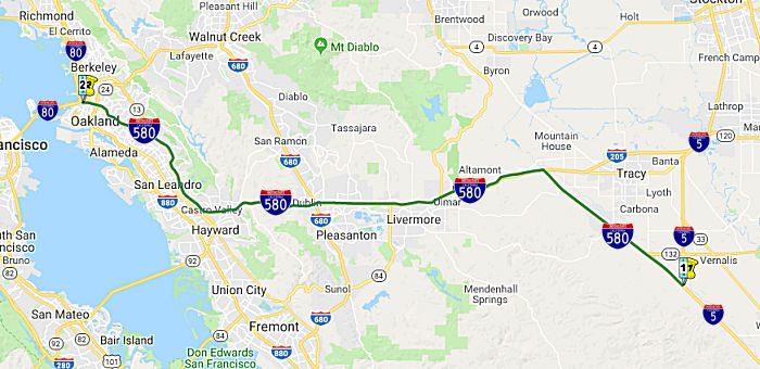 From Route 5 southwest of Vernalis to Route 80 in Oakland via the vicinity of
Dublin and Hayward.
From Route 5 southwest of Vernalis to Route 80 in Oakland via the vicinity of
Dublin and Hayward.
 Suffixed Routings
At one time, portions of this route were signed as I-5W (from near Piedmont to N I-80). All of this segment was tentatively approved as I-5W in 1947, and given full approval in 1958. The I-5W designation was dropped in 1964 (when California regularized route numbers to match legislative definitions, and started dropping all "lettered" alternates to Interstates).
 Post 1964 Signage History
▸In 1963, I-580 was defined as "Route 5 southwest of Vernalis to Route 80 near Oakland via the vicinity of Dublin and Hayward."
In 1966, the MacArthur Freeway portion of I-580 in Oakland was awarded a
1966 Special Award as the Most Beautiful Urban Highway in the US by
Nationwide Parade Magazine. The plaque is located on Grand in Oakland near
the theatre. See the "Naming" Section for a picture of the plaque (or see
here).
(Source: Christy Eiland in Oakland Highways on Facebook, 8/26/2018)
In 1966, the 4.5 mi segment of the 8-lane MacArthur Freeway in Oakland,
between 0.25 mi W of Buell St and the E city limit near Durant Ave was
opened, at a construction cost of $13,110,000. Also completed was the 2.9
mi segment between 0.3 mi E of Sybil Ave to just E of 173rd Ave in San
Leandro and the First Street Interchange near Livermore and the Tassajara
Road interchange at the N city limits of Pleasanton.
(Source: CHPW Nov/Dec 1966)
Oakland / San Leandro Truck Ban
Trucks are banned along the stretch of I-580 that runs
along the base of the East Bay Hills in Oakland and San Leandro. The truck
ban on I-580 dates back to 1951, before the road was even a highway. Then
it was called MacArthur Boulevard and Oakland's City Council wanted to
keep it free from truck traffic. MacArthurs Blvd traverses the Oakland
hills, which were middle and upper middle class, and the flatlands (which
were traversed by US 101E/Route 17 (now I-880) were working class. When
MacArthur Boulevard became a highway in the early 1960s, the City of
Oakland continued the ban on a roughly nine mile stretch of highway
without significant debate. It applied to vehicles weighing more than
9,000 pounds, like big rigs, but not smaller trucks like those delivering
packages on residential streets. The ban also excluded buses. In 1967, the
ban was up for renewal, this time sparking a more intense deliberation.
The possibility that trucks could barrel down both East Bay highways made
people irate. The California Department of Transportation, Caltrans,
studied the issue in 1967 to verify that trucks could travel an alternate
route instead of I-580. The study looked at traffic, not impacts on health
or quality of life. According to their website, the department concluded
that "there was no strong evidence either to retain or to terminate the
truck ban." Caltrans recommended the ban be extended indefinitely, but
with periodic reviews of "operations of the alternate routes, 238 and
880." Those reviews happened just a few times, with none occurring after
1972.
(Source: KQED, 7/1/2021)
In 1990, the California Trucking Association asked
Caltrans to study lifting the ban on trucks on I-580. And according to
their website, Caltrans officials said if they found good reasons to
lift the ban — and the City of Oakland was onboard — they
would recommend opening the freeway to trucks. That study never happened
though. Residents living along I-580 worried studying the issue would open
the door to lifting the ban, so they put pressure on their representatives
to stop the study before it started. The Oakland City Council passed a
resolution affirming they wanted to continue the ban. State legislators
also wanted to stop the study and continue the ban. The Assemblyperson at
the time said her constituents felt that if Oakland and San Leandro lifted
the ban, they would be breaking a promise made to residents decades ago.
The I-580 highway ban is the only one of its kind meant to assuage the
concerns of local residents. According to the Federal Highway Authority,
there are only nine such bans nationwide. Seven of those bans are due to
construction or structural engineering constraints. One ban — on the
Theodore Roosevelt Memorial Bridge in D.C. — was ordered by
President Eisenhower to keep trucks away from the Lincoln Memorial.
(Source: KQED, 7/1/2021)
Through the lens of 2021 understandings of racial equity, the truck ban can be seen as a form of structural racism: routing truck traffic (and the resulting pollution) through the lower income flatland neighborhoods that couldn't protest, and keeping trucks away from the wealthier neighborhoods. One could imagine similar bans had the Beverly Hills freeway (Route 2) been constructed.
 On I-580, at PM ALA R27.742
SB, is one of the few remaining distance signs that is in metric units.
The sign was installed between 1993 and 1995, after the Federal Highway
Administration (FHWA) proposed its metric conversion policy in 1991,
requiring that all highway construction specs and planning would be in
metric units by 1996. If states didn’t comply, the FHWA threatened
to withhold funds for nonmetric projects. Caltrans started to switch to
the Metric System in 1993. However, this mandate soon fell through.
President Bill Clinton signed a law in 1995 that prevented the secretary
of Transportation from requiring any state to use or plan to use the
metric system. In 1999, Caltrans changed its Metrication policy to allow
dual units, Metric and English. By 2006, then-Caltrans chief engineer
Richard Land mandated in a memo that “… all Plans,
Specifications and Estimate submittals … must be in English
units.”
On I-580, at PM ALA R27.742
SB, is one of the few remaining distance signs that is in metric units.
The sign was installed between 1993 and 1995, after the Federal Highway
Administration (FHWA) proposed its metric conversion policy in 1991,
requiring that all highway construction specs and planning would be in
metric units by 1996. If states didn’t comply, the FHWA threatened
to withhold funds for nonmetric projects. Caltrans started to switch to
the Metric System in 1993. However, this mandate soon fell through.
President Bill Clinton signed a law in 1995 that prevented the secretary
of Transportation from requiring any state to use or plan to use the
metric system. In 1999, Caltrans changed its Metrication policy to allow
dual units, Metric and English. By 2006, then-Caltrans chief engineer
Richard Land mandated in a memo that “… all Plans,
Specifications and Estimate submittals … must be in English
units.”
(Source: SF Gate, 1/12/2024; Image source: Reddit)
▸In 1984, Chapter 409 extended the route by transfer from Route 17: "(a) Route 5 southwest of Vernalis to Route 80 near Oakland via the vicinity of Dublin and Hayward. (b) Route 80 near Albany to Route 101 near San Rafael via the Richmond-San Rafael Bridge."
▸In 1990, Chapter 1187 clarified segment (a): "(a) Route 5
southwest of Vernalis to Route 80 in near Oakland
via the vicinity of Dublin and Hayward."
Note: There was once a proposal to connect I-580 with I-505 called the Mid-State Tollway. As some surmised the Mid-State Tollway might be a rerouting of Route 84, the Mid-State Tollway is discussed with Route 84.
 Pre 1964 Signage History
Tom Fearer notes that the first major highway over the present general corridor of I-580 was El Camino Viejo. The El Camino Viejo was an inland
alternate route to the Spanish Missions between Los Angeles and San
Francisco Bay that was in common usage by the 1780s. The route of the El
Camino Viejo from Los Angeles traveled north through San Francisquito
Canyon, Antelope Valley, Cuddy Canyon and San Emigdio to reach San Joaquin
Valley. The El Camino Viejo in San Joaquin Valley followed the west shores
of Tulare Lake and the San Joaquin River close to modern day Tracy where
it picked up what is the general vicinity of the I-580 corridor. Rather
than using Altamont Pass the route of the El Camino Viejo traveled west
from modern day Tracy via Corral Hollow Pass to what is now Livermore. The
route of Corral Hollow Pass has been incorporated into Signed County Sign Route J2.
(Source: Gribblenation Blog: Interstate 580 from I–205 west to CA 13)
 The portion between the I-580/I-205 junction and I-80 was LRN 5,
defined in 1909. This routing was at one time US 48. It was later
renumbered (approximately 1935) as US 50.
The portion between the I-580/I-205 junction and I-80 was LRN 5,
defined in 1909. This routing was at one time US 48. It was later
renumbered (approximately 1935) as US 50.
 In 1954, the CHC held hearings regarding the proposed routing for I-580 (then US 50)
through Oakland. There was generally broad support.
In 1954, the CHC held hearings regarding the proposed routing for I-580 (then US 50)
through Oakland. There was generally broad support.
(Source: Oakland Tribune, 11/18/1954 via Joel Windmiller, 2/13/2023)
The portion of this route between Route 132 and the I-580/I-205 junction was LRN 110, defined in 1957. The short stub between Route 132 and I-5 along I-580 was added to LRN 110 in 1959.
Altamont Pass
 Around 1937-1938, the routing of US 50 near Altamont was changed. Between
Greenvale and Mountain House, US 50 was aligned off the Altamont Pass
Highway to a new alignment. It appears that the pre-1937 alignment used
Byron, Grant Line, and Altamont Pass through the Pass, connecting to 11th
Street in Tracy. This routing was renumbered I-580 in 1964.
Around 1937-1938, the routing of US 50 near Altamont was changed. Between
Greenvale and Mountain House, US 50 was aligned off the Altamont Pass
Highway to a new alignment. It appears that the pre-1937 alignment used
Byron, Grant Line, and Altamont Pass through the Pass, connecting to 11th
Street in Tracy. This routing was renumbered I-580 in 1964.
(Source: Oakland Tribune, 8/3/1938, via Joel Windmiller, 2/3/2023)
The plan was for the new Altamont Pass to be ready for
opening on Labor Day 1938. The existing road had been inadequate to handle
modern high-speed traffic owing to limited sight distances and tortuous
curves. The new road provides for two lanes of traffic in each direction,
separated by a four foot dividing strip. At Greenville, approximately 3 mi
E of Livermore, the new routing crosses the tracks of the Western Pacific
RR and the Southern Pacific RR with a new overhead structure. At Redmond
(or Stone Cut) approx. 3 mi E of Greenville, the railroads are crossed
again with an underpass for the Western Pacific and an overpass for the
Southern Pacific. The overhead structure provides for two 23' two-lane
highway traffic roadways and two 3' pedestrian lanes, with a 4'
separation.
(Source: Tracy Press, 3/18/1938 via Joel Windmiller, 2/20/2023)
The realigned four-lane Altamont Pass Road opened on 8/4/1938. On the eastern grade of the Altamont Pass, the eastbound and westbound I-580 lanes follow different alignments. The EB lanes are the original US 50 alignment. Between the I-580/I-205 split and the Business Route 205 split, most of the width of I-205 (both directions) was the old US 50. It was four-lane divided for some time before the Great Renumbering, and that section is quite a bit narrower than I-580. Of course this may not be original 1927 US 50, but it existed before I-580. US-50 (and possibly US-48) headed into Tracy via Grant Line Road and Byron Road. 11th Street in Tracy is still a divided road in some portions and has a number of old state traffic signals, signs, and lamp poles, including some with the original mercury vapor lamps still intact.
As for the railroad trackage: one of the two lines in the area is the former right-of-way of the Southern Pacific Railroad. These rails were abandoned in 1986 when SP obtained trackage rights over the current ACE route from the Union Pacific Railroad. The SP line, which was constructed in 1869, was actually the final link in the true Transcontinental Railroad. As the ACE Train crosses over, then under, the eastbound and westbound lanes of I-580, there is an abandoned tunnel on the SP right-of-way. The next large cut was actually WP's Tunnel 3. It was daylighted for clearance reasons in the early 1990's.
 In July 1958, the CHC chose a freeway routing for the northerly portion of the West Side
Freeway (future I-5, US 50), extending from the vicinity of Patterson to
junctions with US 50 east and west of Tracy. The routing would extend from
a connection with the previously adopted portion of the West Side Freeway
at Del Puerco Canyon Road W of Patterson to just N of the San Joaquin
County line diverging at that point with one leg leading toward Oakland
and the other leading toward Stockton. Beginning at Del Puerco Canyon
Road, which is the northern end of a 48 mile section for which a routing
was adopted in June 1958, the Stanislaus County portion of the recommended
route is located slightly west of the Delta-Mendota Canal, on a line
generally parallel to Sign Route 33. This portion of the route is 12.3 mi
in length. From just N of the Stanislaus/San Joaquin County line, the
westerly leg (future I-580) continues NW for 15.7 mi to connect with US 50
(future I-580/I-205 junction) in Alameda County. The easterly leg runs N
from the vicinity of the Stanislaus/San Joaquin County line for 11 mi to
connect with US 50 (future I-205) in the vicinity of Grant Line Road. It
crosses Sign Route 33 diagonally about 3 mi N of Vernalis.
In July 1958, the CHC chose a freeway routing for the northerly portion of the West Side
Freeway (future I-5, US 50), extending from the vicinity of Patterson to
junctions with US 50 east and west of Tracy. The routing would extend from
a connection with the previously adopted portion of the West Side Freeway
at Del Puerco Canyon Road W of Patterson to just N of the San Joaquin
County line diverging at that point with one leg leading toward Oakland
and the other leading toward Stockton. Beginning at Del Puerco Canyon
Road, which is the northern end of a 48 mile section for which a routing
was adopted in June 1958, the Stanislaus County portion of the recommended
route is located slightly west of the Delta-Mendota Canal, on a line
generally parallel to Sign Route 33. This portion of the route is 12.3 mi
in length. From just N of the Stanislaus/San Joaquin County line, the
westerly leg (future I-580) continues NW for 15.7 mi to connect with US 50
(future I-580/I-205 junction) in Alameda County. The easterly leg runs N
from the vicinity of the Stanislaus/San Joaquin County line for 11 mi to
connect with US 50 (future I-205) in the vicinity of Grant Line Road. It
crosses Sign Route 33 diagonally about 3 mi N of Vernalis.
(Source: Unspecified newspaper, 7/1958, via Joel Windmiller,
2/16/2023)
 Marine Highway
 Route Description: The M-580 Route connects to
the M-5 route and includes the San Joaquin and Sacramento Rivers, and
connecting commercial navigation channels, ports, and harbors, in Northern
California from Sacramento to Oakland.
Route Description: The M-580 Route connects to
the M-5 route and includes the San Joaquin and Sacramento Rivers, and
connecting commercial navigation channels, ports, and harbors, in Northern
California from Sacramento to Oakland.
(Source: National Maritime Route System, May 2021)
Sponsor: Port of Stockton, California
Supporters: Bay Area Air Quality Management District, San Joaquin Valley Air Pollution Control District, Port of Oakland, and the Port of West Sacramento
Landside Route Served: I-580
Attributes: M-580 is one of the most congested highways in the nation, and has been identified by the U.S. Department of Transportation as having significant annual truck hours of delay. Approximately 25 percent of the Port of Oakland’s volume travels to and from the San Joaquin Valley of California, an area already recognized for some of the country’s worst air pollution. The Port of Oakland’s volume is expected to increase and further exacerbate the Valley’s congestion and air quality issues.
An increased movement of freight by water could help to relieve this situation. In 2007, nearly 3.4 million tons of waterborne cargo, mainly bulk goods, moved through the Port of Stockton via the Stockton Deepwater Ship Channel and San Joaquin River, underscoring the potential capacity of this waterway system. One example of the potential for waterborne freight movements along this Route is a proposed marine highway service between the Ports of Oakland, Stockton, and West Sacramento. Fully implemented, it could eliminate180,000 truck trips from I-580, I-80, and I-205 annually, saving approximately 7-million gallons of fuel and reducing air emissions in the process.
For More Information: National Maritime Highway System
 Status
Note: I-580 is one of five routes in California that have "backwards" post miles: that is, the postmiles go from East to West, instead of the normal West to East. This is an artifact of the original segment of the route being S to N, and then being expanded to an E to W route.
No general items.
In May 2016, the CTC approved $60,464,000 for a project near Livermore, on I-580 from the San Joaquin County line to the Greenville Overhead (PM ALA 0.1 to ALA R8.0); also on I-205 from Midway Road to the San Joaquin County line (PM 205 ALA L0.0 to 205 ALA 0.4); also near Castro Valley on Route 580 from Eden Canyon Road to Strobridge Avenue (PM ALA R26.1 to ALA 30.3); also in San Joaquin County near Tracy on Route 580 from Patterson Pass Road to the Alameda County line (PM SJ 13.5 to 15.3). Outcome/Output: Improve safety and ride quality by rehabilitating 54.6 lane miles of distressed mainline and ramp pavement and install signs, lighting, and vehicle pullouts. Also, install ramp metering at 12 locations.
International Parkway (Mountain House Parkway) Interchanges (205 SJ 1.1/1.6; 580 SJ 13.3/13.8)
 In January 2018, the City of Tracy submitted to the CTC
request that a portion of the Central Valley Gateway Project be approved
for Trade Corridor Enhancement Program (TCEP) funding. At the May 2018 CTC
meeting, staff recommended, and the Commission approved, $12.78 million in
Trade Corridor Enhancement Program funds for the right-of-way and
construction components for the Central Valley Gateway project which
includes the Route 205/International Parkway Interchange Project and the
Route 580/International Parkway Interchange Project. Note that
"International Parkway" is a renaming of Mountain House Parkway.
In January 2018, the City of Tracy submitted to the CTC
request that a portion of the Central Valley Gateway Project be approved
for Trade Corridor Enhancement Program (TCEP) funding. At the May 2018 CTC
meeting, staff recommended, and the Commission approved, $12.78 million in
Trade Corridor Enhancement Program funds for the right-of-way and
construction components for the Central Valley Gateway project which
includes the Route 205/International Parkway Interchange Project and the
Route 580/International Parkway Interchange Project. Note that
"International Parkway" is a renaming of Mountain House Parkway.
The Central Valley Gateway Project is a trucking
corridor along a City’s Surface Transportation Assistance Act of
1982 (STAA) network connecting with State’s Primary Freight Network
(PFN) by way of 2 interchanges on the interstate freeway system. The scope
of the Project includes elements along both the City of Tracy arterial
network as well as both interchanges. While the area is referred to as
‘Cordes Ranch’, in reference to the name of the subdivision in
which entitlements were granted by the City, the name has been changed to
‘International Park of Commerce’, or IPC. The overall Central
Valley Gateway (CVG) Project consists of several infrastructure elements.
These elements include:
(Source: City of Tracy TCEP Application, 1/30/2018)
In 2014, the City of Tracy nominated the I-205/ Mountain House Parkway and I-580/Mountain House Parkway interchange projects to their Metropolitan Planning Organization (MPO) (www.sjcog.org) for inclusion in their Regional Transportation Plan (RTP). The projects were included as 2014 RTP amendments for the “Environmental Only” phase. The scoping documents for the projects were completed in June, 2015 and the environmental phase of the projects were started in early 2017. The construction phases of work are now being included in the 2018 RTP(SCS) by SJCOG. The RTP update is projected to be approved at the November 2018 Board meeting of SJCOG.
Note that the corridor is already home to an Amazon Fulfillment Center and a Costco meat factory.
The SJCOG request noted that the construction of the
Interchange and Parkway Improvements will improve freight and employee
access to the International Park of Commerce (IPC), an industrial, retail
and office park comprised of approximately 1,800 acres and located in the
City of Tracy. The successful development of the Prologis IPC at the foot
of the Altamont Pass is essential for economic sustainability and job
creation in the Tracy/San Joaquin County Region. The initial request was
for $5,000,000 for Plans, Specifications, and Cost Estimates (PSE’s)
and/or right of way acquisition for (IPC) Interchange and Parkway
improvements connecting I-205 and I-580 in Tracy, California. The total
improvements to the interstate interchanges and connecting parkway will
include:
(Source: SJCOG International Parkway brochure)
In December 2018, Agenda Item 4.24 on the CTC agenda
addressed this project, noting that the Trade Corridor Enhancement Program
guidelines state that projects programmed with capital costs must file a
Notice of Determination, in accordance with the California Environmental
Quality Act, within six months of program adoption, or the project will be
removed from the program. Based on this requirement, a Notice of
Determination for the Central Valley Gateway project was required to be
filed by November 16, 2018. The City of Tracy did not meet this deadline,
therefore, consistent with the Trade Corridor Enhancement Program
guidelines, staff recommended (and the CTC approved) the removal of City
of Tracy’s Central Valley Gateway Project.
(Source: December 2018 CTC Minutes, Agenda Item 4.24)
 In January 2021, it was reported that South San Joaquin
County’s second diverging diamond interchange will be built in
Tracy. The $24.8 million project will convert the existing interchange on
I-580 at International Parkway into a configuration that mirrors the
diverging diamond design that opened in Manteca at Union Road and the
Route 120 Bypass in November. The Manteca interchange is the first
diverging diamond in California. A diverging diamond interchange is also
planned at Route 99 and Mitchell Road in Ceres. Construction on the Tracy
interchange is targeted to start in the fall 2022. The diverging diamond
design uses less land, are less expensive to build, reduce the potential
for accidents, eliminates the most dangerous conflicts resulting in
serious injuries that are left turns, reduces traffic signals, and allows
for better traffic flow. The I‐580 at International Parkway
interchange project will reconstruct the existing interchange, widening
the on- and off-ramps, and widen the freeway overcrossing to increase
traffic capacity and truck throughput. The project will modify the current
configuration to a diverging diamond interchange. This design will allow
for free movements onto the interstate, improving safety and access to
important freight routes. The new I‐580 Interchange will also
include continuous Class II bike lanes and sidewalks, providing safe
passage for bicycles and pedestrians over the freeway. The City of Tracy,
in partnership with Caltrans, submitted a Trade Corridor Enhancement
Program grant funding application for construction funding for the I-580
Interchange. The project competed against 46 other projects from across
the State and was awarded $24,884,000 in State funding. Development in
Cordes Ranch near the I-205/I-580 interchange began in 2013. Cordes Ranch,
now named the International Park of Commerce (IPC), consists of 450 acres
and 20 million square feet of fulfillment center, flex-office,
distribution center, and warehouse space and represents what is cutting
edge within the e-commerce market. The IPC is home to large logistics
centers for Amazon, Costco, Safeway, and Smuckers and is projected to
contribute up to 16,000 jobs to the City of Tracy. The new interchange
design will reduce congestion and improve goods movement from the IPC to
critical freight highways. Information and updates on the I-580 at
International Parkway Interchange can be found on the project website: https://205and580interchanges.com.
In January 2021, it was reported that South San Joaquin
County’s second diverging diamond interchange will be built in
Tracy. The $24.8 million project will convert the existing interchange on
I-580 at International Parkway into a configuration that mirrors the
diverging diamond design that opened in Manteca at Union Road and the
Route 120 Bypass in November. The Manteca interchange is the first
diverging diamond in California. A diverging diamond interchange is also
planned at Route 99 and Mitchell Road in Ceres. Construction on the Tracy
interchange is targeted to start in the fall 2022. The diverging diamond
design uses less land, are less expensive to build, reduce the potential
for accidents, eliminates the most dangerous conflicts resulting in
serious injuries that are left turns, reduces traffic signals, and allows
for better traffic flow. The I‐580 at International Parkway
interchange project will reconstruct the existing interchange, widening
the on- and off-ramps, and widen the freeway overcrossing to increase
traffic capacity and truck throughput. The project will modify the current
configuration to a diverging diamond interchange. This design will allow
for free movements onto the interstate, improving safety and access to
important freight routes. The new I‐580 Interchange will also
include continuous Class II bike lanes and sidewalks, providing safe
passage for bicycles and pedestrians over the freeway. The City of Tracy,
in partnership with Caltrans, submitted a Trade Corridor Enhancement
Program grant funding application for construction funding for the I-580
Interchange. The project competed against 46 other projects from across
the State and was awarded $24,884,000 in State funding. Development in
Cordes Ranch near the I-205/I-580 interchange began in 2013. Cordes Ranch,
now named the International Park of Commerce (IPC), consists of 450 acres
and 20 million square feet of fulfillment center, flex-office,
distribution center, and warehouse space and represents what is cutting
edge within the e-commerce market. The IPC is home to large logistics
centers for Amazon, Costco, Safeway, and Smuckers and is projected to
contribute up to 16,000 jobs to the City of Tracy. The new interchange
design will reduce congestion and improve goods movement from the IPC to
critical freight highways. Information and updates on the I-580 at
International Parkway Interchange can be found on the project website: https://205and580interchanges.com.
(Source: Manteca/Ripon Bulletin, 1/8/2021)
In May 2021, the CTC approved for future consideration
of funding the following project: 10-SJ-580, PM 12.6/14.3. Interchange
Improvements at I-580 at International Parkway/Patterson Pass Road.
Improve the I-580 interchange at International Parkway/Patterson Pass Road
in San Joaquin County. (MND) (PPNO 3416) (STIP). This project is located
on I-580 at the International Parkway/Patterson Pass Road between Post
Mile 12.6 and Post Mile 14.3. The purpose of this project is to modify the
interchange from the existing Compact Diamond to a Diverging Diamond
Interchange. This project is fully funded and is currently programmed in
the 2020 State Transportation Improvement Program (STIP) for a total of
$49,183,000, which includes local funds, and Senate Bill 1 Trade Corridor
Enhancement Program funds. Construction is estimated to begin in
2022. The scope, as described for the preferred alternative, is consistent
with the project scope programmed by the Commission in the 2020 STIP. A
Mitigated Negative Declaration (MND) has been completed. The project
will result in less than significant impacts to the environment after
mitigation. The following resource areas may be impacted by the
project: paleontological resources, wetlands and other waters, threatened
and endangered species, and plant species. Avoidance and minimization
measures will reduce any potential effects on the environment. These
measures include, but are not limited to, the preparation of a
Paleontological Evaluation Report and Paleontological Mitigation Plan, the
establishment of environmentally sensitive areas to protect wetlands and
special status species, and the purchase of compensatory credits for
affected habitat types from a United States Army Corps of
Engineers-approved mitigation bank.
(Source: May 2021 CTC Agenda, Agenda Item 2.2c.(1))
In June 2023, the CTC approved the following allocation
for a locally-administered TCEP project: $24,884,000. 10-SJ-580 12.6/14.3.
PPNO 10-3416; ProjID 1015000011; EA 1E220. I-580/ International
Parkway Interchange. The Project is located in the City of Tracy at
the I-580 and International Parkway/Patterson Pass Road interchange. Due
to increased commercial truck and traffic demand from existing fulfillment
and distribution center growth and planned future development in San
Joaquin County, the Project proposes to modify the interchange from the
existing compact diamond (Type L-1) to a Diverging Diamond Interchange
(DDI). The Project reduces congestion, increases truck throughput, and
eliminates a bottleneck for trucks accessing I-580, a key freight highway.
The Project will improve interregional goods movement for trucks traveling
between the Port of Oakland, Bay Area, local warehouses, Southern
California, and out-of-state. CEQA - MND, 02/25/2021; Re-validation
04/17/2023 NEPA - CE, 02/25/2021; Re-validation 04/17/2023. Right of Way
Certification: 04/17/2023. Future consideration of funding approved under
Resolution E-21-40; May 2021. Time Extension for FY 21-22 CONST expires on
June 30, 2023. Contribution from local sources: $25,287,000. Allocation:
CONST $18,531,000 (TCEP-R/21-22) + $6,353,000 (TCEP-S/21-22).
(Source: June 2023 CTC Agenda, Agenda Item 2.5s.(14))
In July 2008, Caltrans opened the I-580 truck bypass, separating slow-moving trucks from cars in the Altamont Pass. Two westbound truck-only lanes run for six miles from Mountain House Parkway to Grant Line Road (~ SJ 13.582 to ALA R1.491) on the left-hand side. This was added as part of widening I-205, and is part of the I-205 to I-580 transition. It permits trucks to make the transition at ground level and join the freeway on the right hand lanes, whereas the original flyover ramp joins the freeway in the left hand (fast) lanes. After this project has completed, regular traffic were then redirected to use the new bridge, which merges to the left of I-205.
I-205 to I-680 (Altamont Pass, Livermore, Pleasanton)
Greenville Truck Lanes (~ ALA R4.907R to ALA R8.254)
In January 2011, the CTC approved for future consideration of funding a project in Alameda County that will construct a truck climbing lane in the eastbound direction on I-580 from one mile east of North Flynn Road to Greenville Road Undercrossing (~ ALA R4.907R to ALA R8.254). The project is programmed in the Trade Corridors Improvement Fund. Construction is estimated to begin in Fiscal Year 2011-12. Total estimated project cost is $63,000,000 for capital and support. The project will mitigate potential impacts to biological resources to a less than significant level. Potential impacts to seven animal species that are listed as threatened or endangered will be mitigated through replacement habitat. In addition, potential impacts to an existing wetland in the project area will be mitigated by restoration of the affected wetland. In October 2012, the CTC amended the schedule due to permitting problems. The new schedule shows construction completing in April 2015.
In March 2016, it was reported that Caltrans expects to
open a truck lane on eastbound I-580 in Livermore between Greenville and
North Flynn roads in June 2016. One more layer of asphalt needs to go in
first.
(Source: SJ Mercury News, 3/12/2016)
In May 2012, the CTC authorized SHOPP funding on I-580, in Alameda County, 04-Ala-580 R8.4/R14.6 Near Livermore, from 0.1 mile west of Greenville Road to 0.2 mile west of San Ramon -Foothill Road. $16,400,000 to rehabilitate 51 lane miles of roadway to improve the ride quality, prevent further deterioration of the road surface, minimize the costly roadway repairs and extend the pavement service life.
Livermore HOV/Express Lanes (~ ALA R8.254 to ALA R21.435)
 TCRP Project #12.3 is studying improvements for the I-580
Livermore Corridor (~ ALA R9.347 to ALA 17.943). The project is to
construct eastbound and westbound High Occupancy Vehicle (HOV) lanes on
I-580 from west of Tassajara Road in Pleasanton to east of Vasco Road in
Livermore, a distance of approximately 18 kilometers (11 miles). The total
estimated cost of the project depends on selection of preferred
alternative at the conclusion of the environmental clearance process, and
ranges from $109,500,000 (minimum project alternative) to $200,500,000
(ultimate project). The selection of the preferred alternative will be
made in coordination with the Route 580 Transit Connectivity Study (TCRP
#12.3). Included in the Transit Connectivity Study are alternative
alignments for transit along the Route 580 corridor.
TCRP Project #12.3 is studying improvements for the I-580
Livermore Corridor (~ ALA R9.347 to ALA 17.943). The project is to
construct eastbound and westbound High Occupancy Vehicle (HOV) lanes on
I-580 from west of Tassajara Road in Pleasanton to east of Vasco Road in
Livermore, a distance of approximately 18 kilometers (11 miles). The total
estimated cost of the project depends on selection of preferred
alternative at the conclusion of the environmental clearance process, and
ranges from $109,500,000 (minimum project alternative) to $200,500,000
(ultimate project). The selection of the preferred alternative will be
made in coordination with the Route 580 Transit Connectivity Study (TCRP
#12.3). Included in the Transit Connectivity Study are alternative
alignments for transit along the Route 580 corridor.
The minimum project alternative would add HOV lanes in the existing median. The ultimate project would include widening the median to 19.5 meters (64 feet) for future BART extension and 25.6 meters (84 feet) near Airway Boulevard for proposed West Livermore BART station. Widening of the freeway could be to the outside to accommodate shifting the existing lanes and construction of the new HOV lanes.
As of 2003, the TCRP funding was anticipated to fully fund Phases 1, 2, and right of way services (Phase 3), and partially fund construction support (Phase 4). Of the total maximum $200.5 million required for ultimate project implementation, a total of $119.5 million is identified as committed or proposed funding. The remaining $81 million could be an unmet balance for which funding source(s) is/are yet to be identified. The currently identified $119.5 million committed and potential funding sources would allow for the development and construction of a minimum project alternative and meeting the project purpose and needs.
The SAFETEA-LU act, enacted in August 2005 as the reauthorization of TEA-21, provided the following expenditures on or near this route:
In 2007, the CTC recommended $72.2M from the Corridor Mobility Improvement Account (CMIA) for an EB HOV Lane from Greenville Road in Livermore to Hacienda Drive in Pleasanton (~ ALA R8.254 to ALA 18.834), and $68M for a WB HOV Lane at the Isabel Ave (Route 84) interchange (~ ALA 14.15), and $101.7M for a WB HOV Lane from Greenville to Foothill Road (~ ALA R8.254 to ALA R21.435).
In October 2008, a segment of HOV lanes in Livermore opened.
In February 2009, the CTC amended the environmental work for the project. Specifically, on July 27, 2007, the CTC approved a resolution that revised the project schedule to show FY2008-09 as the completion date for Environmental portion of the project. At the same time, the CTC approved a resolution that allocated $3,000,000 for a Programmatic Environmental Impact Report (PEIR), which was proposed to be developed by December 2008. The purpose of the PEIR was to support the early acquisition of right of way along I-580 for a future transit corridor. However, the schedule required modification in 2009 as it was dependent on inclusion of a right of way preservation project-known as the “I-580 Transit Corridor”-in the regional transportation plan (RTP) currently being developed by the Metropolitan Transportation Commission (MTC). MTC is scheduled to adopt the Final Plan, EIR, and Conformity Analysis for the RTP on March 25, 2009. The amendment changed the completion date for the environmental phase to December 2009.
In February 2010, the CTC approved allocating $8,000,000 in Traffic Congestion Relief Program (TCRP) funds for the Route 580 project to construct an eastbound HOV lane from Tassjara Road/Santa Rita Road to Vasco Road in Alameda County (TCRP 31).
![[PPNO 0112B]](maps/580-ppno0112.jpg) In April 2010, the CTC approved for future consideration of funding a project in Alameda County that will
construct a westbound HOV lane on a 13.4 mile portion of Route 580 near
the city of Dublin. The project is programmed in the Corridor Mobility
Improvement Account and includes federal and local funds. Total estimated
project cost is $137,886,000 for capital and support. Construction is
estimated to begin in Fiscal Year 2011-12. There is a concurrent baseline
amendment request to split the project into three contracts. The scope, as
described for the preferred alternative, is consistent with the project
scope set forth in the proposed project baseline agreement.
In April 2010, the CTC approved for future consideration of funding a project in Alameda County that will
construct a westbound HOV lane on a 13.4 mile portion of Route 580 near
the city of Dublin. The project is programmed in the Corridor Mobility
Improvement Account and includes federal and local funds. Total estimated
project cost is $137,886,000 for capital and support. Construction is
estimated to begin in Fiscal Year 2011-12. There is a concurrent baseline
amendment request to split the project into three contracts. The scope, as
described for the preferred alternative, is consistent with the project
scope set forth in the proposed project baseline agreement.
Overall, this project will construct a high occupancy vehicle (HOV) lane from the San Ramon Road/Foothill Road Interchange to the Greenville Road Overhead; widen the inside and outside shoulders sufficiently to accommodate the HOV lane and allow for future conversion of the HOV lane to a high occupancy toll (HOT) lane; widen the existing bridge crossings over Tassajara Creek and Arroyo Las Positas Creek at various locations; and construct various westbound auxiliary lanes. It will also construct a westbound express bus ramp connection from the westbound HOV lane to the Dublin-Pleasanton BART Station; construct soundwalls as identified by the environmental document; and upgrade the drainage system in the freeway median to accommodate the HOV lane. In April 2010, the CTC approved amending the CMIA baseline agreement for the I-580 Westbound HOV Lane – Greenville to Foothill project (PPNO 0112B) to: (1) Update the project scope to eliminate the westbound I-580 express bus off-ramp to the Dublin-Pleasanton Bay Area Rapid Transit (BART) Station, funded by 12 million Regional Measure 2 (RM2) funds; add a westbound auxiliary lane at two locations: a) From Vasco Road to First Street and b) From Airway Boulevard to Fallon Road, to be funded by local funds; (2) Update the overall project funding plan; and (3) Split the updated project into three roadway contracts. The westbound express off-ramp to the BART station is being elminated because both the BART and the Livermore Amador Valley Transit Authority opposed the inclusion of these improvements in the project scope on concerns relating to pedestrian safety in the vicinity of the BART Station; this provided a cost savings of $12M. The auxiliary lanes were added to the scope of the overall project for coordination purposes; these lanes were originally a local project. Combining these two auxiliary lanes projects with the HOV lane project for construction will reduce throw-away costs such as roadway drainage improvements, signings, and erosion control measures and also avoid unnecessary disruption to the traveling public.
The overall project is proposed to be split into three segments.
Segment 2 (PPNO 0112F): In Alameda County in Livermore from just east of Isabel Avenue to just west of San Ramon Road/Foothill Road Interchange. Construct a westbound HOV lane from Isabel Avenue Overcrossing to San Ramon Road/Foothill Road Interchange. Widen the inside and outside shoulders sufficiently to accommodate the HOV lane and allow for future conversion to a HOT lane. Widen existing bridge crossing over Tassajara Creek. Construct westbound auxiliary lanes from Airway Boulevard to Fallon Road. Construct soundwalls as identified by the environmental document. Construct mitigation landscaping. Upgrade the freeway median drainage system in the freeway median to accommodate the HOV lane.
Segment 3 (PPNO 0112G): In Alameda County in Livermore from just west of First Street Overcrossing to just west of Isabel Avenue Overcrossing. Widen existing bridge crossings over Arroyo Las Positas Creek in the eastbound direction (at two locations).
In July 2010 it was reported that a 2.9-mile HOV lane segment opened in Livermore: EB from Airway Boulevard past Portola Road. Upon completion, the entire HOV lane will extend 11 miles from Hacienda Road in Pleasanton to Greenville Road in Livermore. It will eventually be turned into an express toll lane. The first lane segment from east of Portola Road to Greenville Road opened in October 2009. If construction continues as expected, the overall HOV project will open in Fall 2010, about one year ahead. In November 2010, it was reported that the second phase of the 11-mile carpool lane on eastbound I-580 between Pleasanton and Livermore was opened. The carpool lane is expected to ease traffic in the area, which currently sees more than 170,000 vehicles a day. The project cost $49 million, which is $23 million less than what had been budgeted, and was completed a year ahead of schedule. It was mostly funded by Proposition 1B, a $19.9 billion transportation bond that was approved by California voters in 2006. Transportation officials said the project was completed for far less than had been expected because of the highly competitive bidding market among contractors seeking business. The section that opened in November 2010 goes from Hacienda Drive in Pleasanton to Portola Road in Livermore. The first segment, which is from Portola Road to Greenville Road in Livermore, opened in October 2009.
In August 2010, the CTC approved amending the CMIA baseline agreement for Segment 2 (Construct HOV Lane, from Portola to Hacienda [PPNO 0112D]) of the Eastbound I-580 HOV Lane project to update the project delivery schedule, noting that construction started later than originally expected.
 In April 2012, it was reported that construction on the
$182 million-dollar HOV lane between Livermore and Dublin is scheduled to
begin in August 2012 and be completed in mid-2015. Eastbound commuters --
who have benefited from an 11-mile carpool lane from Hacienda Drive to
Greenville since 2009 -- will see the lane transformed into a combination
carpool-toll lane. The cost to add the technology for the lane, which was
$15 million to build, is $19 million, and it will open at the same time
the westbound lane debuts.
In April 2012, it was reported that construction on the
$182 million-dollar HOV lane between Livermore and Dublin is scheduled to
begin in August 2012 and be completed in mid-2015. Eastbound commuters --
who have benefited from an 11-mile carpool lane from Hacienda Drive to
Greenville since 2009 -- will see the lane transformed into a combination
carpool-toll lane. The cost to add the technology for the lane, which was
$15 million to build, is $19 million, and it will open at the same time
the westbound lane debuts.
In February 2013, it was reported that Caltrans plans to convert HOV lanes on I-580 into HOT ("Express" or High Occupancy/Toll) lanes -- specifically, I-580 in both directions between I-680 and Hacienda Road in Livermore. Express lanes work by continuing to allow carpoolers free access to the fast lane but then selling unused capacity to drivers who wouldn't normally qualify to drive in them. Tolls are collected electronically using FasTrak transponders, and electronic systems are used to monitor traffic and set tolls at a rate designed to keep traffic in the lanes flowing at 50 mph or faster. As the lanes get more congested, tolls rise, and as gridlock eases, they drop. Toll rates for the network have not been set yet, but on the existing lanes they have varied from a 30-cent minimum to about $5 or $6.
In mid-June 2013, A ceremony was held to mark the start of construction on the $145 million new HOV lanes between Greenville Road in Livermore and the Foothill Road over crossing in Dublin and Pleasanton. Completion is expected in late 2014, a year before the lane is to be converted into an express toll lane open to carpools for free and solo drivers for a toll. Contractors also will add an auxiliary lane on I-580 between Isabel Avenue and First Street in Livermore.
In September 2015, it was reported that the opening of
the I-580 HOT lanes along both directions of I-580 through Pleasanton,
Dublin and Livermore would be delayed. The I-580 project, which began
construction in June 2014, is converting the eastbound high-occupancy
vehicle (HOV) lane and another lane into two express lanes from Hacienda
Drive to Greenville Road in Livermore. For the westbound direction, a
single express lane will run from Greenville to the San Ramon/Foothill
roads overcrossing, creating the first HOV-specific lane on westbound
I-580 through the corridor. New driving lanes were previously built in
each direction as part of separate HOV and auxiliary lanes projects. The
express lanes would be free to access for carpools, vanpools, public
transit, motorcycles and eligible clean-air vehicles while other solo
drivers could pay a toll to use the lanes from 5 a.m. to 8 p.m. Mondays
through Fridays. The lanes would be open free-of-charge all other times.
Express lane access will be nearly continuous, except for limitations
eastbound between Hacienda and Fallon and El Charro roads and westbound
between Hacienda and San Ramon Road. The project had construction delays
on the civil infrastructure due to material shortages. Additionally, among
the project components still to be completed is the adoption of a toll fee
schedule. The agency will use dynamic pricing, with toll rates going up or
down to help traffic move smoothly. Tolls will increase as express lane
congestion increases -- in an effort to discourage solo drivers from using
the express lanes. The logic is reversed when congestion eases. A
motorists' toll rate is locked in as soon as they enter the lane, and the
rate remains the same for the duration of their trip, regardless of any
rate changes during that time. Drivers who enter the lanes will be
required to use a FasTrak Flex reader, which offers adjustable settings
based on one, two or three-plus vehicle occupants.
(Source: Pleasanton Weekly, 9/25/2015)
In February 2016, it was reported that HOT lanes on
I-580 from Dublin to Livermore had opened. This marks the biggest
expansion of using carpool lanes as express lanes in the region, with two
lanes eastbound and one lane westbound for 12 miles or 36 miles in total.
The express lanes will operate from 5 a.m. to 8 p.m. weekdays. At other
times, they'll be open to all drivers. Minimum tolls will be in the $1.50
to $1.75 range. FasTrak will be required by all users even carpoolers.
FasTrak Flex toll tags (i.e., the type used in Southern California) will
be required. They can be set at one, two or three to indicate the number
of people in the car and can be used anywhere FasTrak can be used, such as
on I-680 through Fremont, Route 237 in Milpitas, and the HOT lanes on I-15
and I-10. Operated by the Alameda County Transportation Commission, these
lanes were funded with federal, state, regional and local dollars,
including a voter-approved sales tax. The toll lanes cost $55 million, but
the overall cost to widen the freeway and add numerous merging lanes
raised the final bill to $345 million.
(Source: Mercury News, 1/22/2016, EastBay
Times, 2/10/2016)
In an AAroads post on the subject, additional
informaton on the FasTrack Flex tag was provided. Joe Rouse (of m.t.r and
AAroads fame) came up with the name, inspired by what the EZPass group on
the East Coast did for their switchable tag for the express lanes on
I–495 and I–95 in Virginia, with the special branding of
EZPass Flex. The California Toll Operators Committee (CTOC) adopted it
after some market research and approval by the Transportation Corridor
Agencies (which owns the FasTrak trademark). The branding came about as a
result of an issue with the I-10 and I-110 express lanes in Los Angeles.
LA Metro offers only a switchable tag to its customers. It was branded as
FasTrak. Yet there are a substantial number of older non-switchable tags
in use in Southern California that were issued by TCA and OCTA, also
branded as FasTrak. The pricing signs on the 2 express lanes in Los
Angeles were displaying a message that HOVs with FasTrak didn't have to
pay a toll. However, this was only applicable if you had the switchable
tag. No switch - you'd still pay. A few people had caught on to this
distinction, and there was concern that it could lead to legal action
because the signs were conveying a misleading message. The toll operators
saw this same risk and agreed that a separate brand would help. Guidance
was developed on the use of the brand and one of the things that I made
very clear was that the brand should only be used in messaging related to
carpooling. For this reason, when you drive the I-580 express lanes, most
signs only say "FasTrak". The FasTrak Flex brand is only displayed on
messages pertaining to HOVs. The messaging on those signs was taken from
the I–495 express lanes in Virginia. The Bay Area was the first
region to adopt the FasTrak Flex branding. The express lanes in Los
Angeles will adopt it eventually. A couple of media outlets reported that
you could ONLY use the I-580 express lanes if you had the FasTrak Flex.
That's not true because that would violate California's interoperability
law. One final note: if you use a traditional toll facility like a toll
bridge or toll road, the setting on the switch tag doesn't matter. The
switch setting is tied in with one component of the tag that is typically
not scanned by the overhead readers. The tag readers on the LA express
lanes and the new express lanes in the Bay Area will scan that component.
I'm not sure about the existing express lanes on Route 237 and I-680.
Eventually both of those facilities will start requiring all users to
carry a tag, though, and require the Flex tag for toll-free travel.
(Source: Joe Rouse @ AAroads, 2/24/2016)
In August 2016, it was reported that notorists took
nearly 1.9 million trips on I-580's new express lanes in Alameda County in
the first four months the lanes opened to vehicle traffic. The first full
month of operation saw around 549,000 trips along the east- and westbound
lanes, growing to 647,000 trips in May -- an 18 percent increase from
March -- according to a report presented to the Alameda County
Transportation Commission. Average hourly speeds in the express lanes are
estimated to be between 10 and 33 mph faster than the average hourly
speeds in general purpose lanes during the morning rush-hour commute.
(Source: East Bay Times, 7/29/2016)
In March 2017, it was reported that since the
combination express and carpool lanes opened in February 2016 on I-580,
along the main route between the Bay Area and the Central Valley, more
than 7.6 million drivers have taken advantage of them, according to a
report released in March 2017 by the Alameda County Transportation
Commission, which operates the lanes. By paying an average toll of $1.62
westbound and $2.13 eastbound, drivers get to drive about 10 mph faster
than those in the other lanes. On an average day, about 11 percent of the
vehicles traveling on I-580 through the area use the express lanes.
That’s about 30,000 cars and trucks a day. Looking at February
alone, the figures show that of the estimated 30,000 vehicles to use the
580 Express Lanes daily, 52 percent paid a toll and 38 percent legally
traveled toll-free under diamond lane rules. The percent of toll-lane
cheats fell from about 30 percent when the lanes opened a year ago to 10
percent last month, the report said.
(Source: SF Chronicle, 3/16/2017)
The SAFETEA-LU act, enacted in August 2005 as the reauthorization of TEA-21, provided the following expenditures on or near this route:
In May 2013, the CTC relinquished right of way in the city of Livermore along Route 580 on Kitty Hawk Road and Portola Avenue, consisting of collateral facilities (~ 04-Ala-580-PM 13.2/14.3).
Isabel Avenue Interchange (~ ALA 14.15)
The SAFETEA-LU act, enacted in August 2005 as the reauthorization of TEA-21, provided the following expenditures on or near this route:
 There are plans to add a new interchange as Isabel Avenue in Livermore, but this was deferred in June
2008 because the cost and scope of ED is not consistent with cost and
scope of CMIA baseline agreement.. The project is fully programmed for
$153 million with Corridor Mobility Improvement Account (CMIA) funds,
federal Demonstration funds, and local funds. Construction is estimated to
begin in Fiscal Year 2008-09.. There was a similar deferral of a project
to construct roadway improvements on I-580 in the city of Livermore that
would have extended out to I-205. The project is fully programmed for $154
million with Corridor Mobility Improvement Account (CMIA) funds; State
Transportation Improvement Program (STIP) funds; State Highway Operation
Protection Program (SHOPP) funds; Safe, Accountable, Flexible, Efficient
Transportation Equity Act: A Legacy for Users (SAFETEA-LU) funds; Traffic
Congestion Relief Program (TCRP) funds; and local funds. Construction is
estimated to begin in Fiscal Year 2007-08.
There are plans to add a new interchange as Isabel Avenue in Livermore, but this was deferred in June
2008 because the cost and scope of ED is not consistent with cost and
scope of CMIA baseline agreement.. The project is fully programmed for
$153 million with Corridor Mobility Improvement Account (CMIA) funds,
federal Demonstration funds, and local funds. Construction is estimated to
begin in Fiscal Year 2008-09.. There was a similar deferral of a project
to construct roadway improvements on I-580 in the city of Livermore that
would have extended out to I-205. The project is fully programmed for $154
million with Corridor Mobility Improvement Account (CMIA) funds; State
Transportation Improvement Program (STIP) funds; State Highway Operation
Protection Program (SHOPP) funds; Safe, Accountable, Flexible, Efficient
Transportation Equity Act: A Legacy for Users (SAFETEA-LU) funds; Traffic
Congestion Relief Program (TCRP) funds; and local funds. Construction is
estimated to begin in Fiscal Year 2007-08.
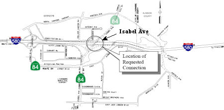 Specifically, the project will construct a new interchange at Isabel Avenue (Route 84) and Route 580
in the city of Livermore. The project will also remove the existing
partial interchange at Portola Avenue and I- 580. This new interchange at
Isabel Avenue will provide a permanent and more efficient connection
between Route 580 and Route 84. These improvements will result in a
congestion relief in the Route 580/Route 680 corridors by establishing an
alternative route for traffic between the Central/Tri-Valleys and the
South Bay areas. In October 2008, the CTC considered amending the project
plan to reallocate funding between tasks and to divide the project into
three segments. This was due to an increase in right of way (ROW)
acquisition costs of $3.1 million, due to the refinement of ROW costs that
are now based upon actual appraisals, negotiated property acquisition
compensations, and updated utility relocation estimates. This brought the
total ROW costs to $24M. Additionally, construction estimates have also
increased by $10.9M to $96.6M. That's just for Construction Capital!
Construction support is another $8M (but that's a decrease of $8M from the
original estimate). The amendment proposed that the work relating to the
construction of three foundations for the Isabel Avenue Overcrossing
(estimated cost $1.75 million) be transferred from this project to another
CMIA project, the Route 580 EB HOV Lane project (PPNO 0112A, Segment 2 [EA
04-290831]). Similarly, widening of the Arroyo Las Positas Bridge
(estimated cost $1.70 million) was to be transferred from the Route 580 EB
HOV Lane project to the Isabel Avenue interchange project. They also
proposed splitting the project into three construction contracts, allowing
the City of Livermore to administer construction of the work that is
within its own right of way, and thus better deal with traffic controls
and circulation impacts on the city roads.
Specifically, the project will construct a new interchange at Isabel Avenue (Route 84) and Route 580
in the city of Livermore. The project will also remove the existing
partial interchange at Portola Avenue and I- 580. This new interchange at
Isabel Avenue will provide a permanent and more efficient connection
between Route 580 and Route 84. These improvements will result in a
congestion relief in the Route 580/Route 680 corridors by establishing an
alternative route for traffic between the Central/Tri-Valleys and the
South Bay areas. In October 2008, the CTC considered amending the project
plan to reallocate funding between tasks and to divide the project into
three segments. This was due to an increase in right of way (ROW)
acquisition costs of $3.1 million, due to the refinement of ROW costs that
are now based upon actual appraisals, negotiated property acquisition
compensations, and updated utility relocation estimates. This brought the
total ROW costs to $24M. Additionally, construction estimates have also
increased by $10.9M to $96.6M. That's just for Construction Capital!
Construction support is another $8M (but that's a decrease of $8M from the
original estimate). The amendment proposed that the work relating to the
construction of three foundations for the Isabel Avenue Overcrossing
(estimated cost $1.75 million) be transferred from this project to another
CMIA project, the Route 580 EB HOV Lane project (PPNO 0112A, Segment 2 [EA
04-290831]). Similarly, widening of the Arroyo Las Positas Bridge
(estimated cost $1.70 million) was to be transferred from the Route 580 EB
HOV Lane project to the Isabel Avenue interchange project. They also
proposed splitting the project into three construction contracts, allowing
the City of Livermore to administer construction of the work that is
within its own right of way, and thus better deal with traffic controls
and circulation impacts on the city roads.
So, the project will include (a) construction of a new interchange at Isabel Avenue (Route 84) in the Route 580 Corridor, replacing the existing temporary connection at Route 580/Airway Blvd; (b) construction of a new Portola Avenue overpass; (c) construction of eastbound and westbound auxiliary lanes between Isabel Avenue and Airway Boulevard, (d) removal of the partial interchange at Route 580/Portola Ave. for enhanced mainline operational efficiency and safety.; (e) widening and realigning of SR 84 south of Route 580, including relocation of utilities; (f) construction of new local roads necessary for the interchange operation north of Route 580; (g) widening an existing Route 580 bridge over the Arroyo Las Positas creek to accommodate the Route 580 EB HOV Lane project. The Arroyo Las Positas Creek Bridge widening was added from Route 580 EB HOV Lane project. Some foundation work in the median for the Route 580/Isabel Avenue Interchange project was deleted from this project and added to the Route 580 EB HOV Lane project. The three construction contracts are: (04-171311) Widen and realign Route 84 south of I-580, including relocation of utilities; (04-171321) Construct new local roads north of the I-580/Isabel Avenue Interchange, for proper operations of the interchange; and (04-171331) (a) Construct new interchange at I-580 and Isabel Avenue (Route 84) replacing the existing temporary connection at I-580/Airway Blvd; (b) construct a new Portola Avenue overpass; (c) construct eastbound and westbound auxiliary lanes between Isabel Avenue and Airway Boulevard; (d) remove the partial interchange at I-580/Portola Ave. (e) widen an existing I-580 bridge over the Arroyo Las Positas creek to accommodate the I-580 EB HOV project. The first two of these (171311 and 171321) would be done by the City of Livermore; the last by Caltrans.
In January 2010, it was noted that construction near I-580 and Route 84 was progressing nicely. it's visibly becoming an interchange with approach embankments looking done on both sides. Completion is scheduled for February 2011.
In August 2010, the CTC approved amending the CMIA baseline agreements for Segment 1 (Widen and realign SR-84/Isabel Avenue [PPNO 0115E]), Segment 2 (Construct new local roads north of I-580/Isabel Interchange [PPNO 0115F]) and Segment 3 (Construct new interchange at Isabel Avenue [PPNO 0115B]) of the I-580/ Isabel Interchange project to update the project delivery schedule for each project. All three segments received their allocations at the December 2008 Commission meeting. The contracts for Segment 1 and 2 were advertised on December 22, 2008. The Segment 3 was advertised in January 2009. But the bid openings had to be postponed because the Proposition 1B funding was suspended due to financial constraints of the State. For Segment 3, delay in bid opening was also caused by the issuance of three addenda. The contracts for Segment 1 and 2 were awarded in June 2009. The Segment 3 contract was awarded in July 2009. None of the changes affect the close-out dates, although the end of construction for Segment 1 is pushed out two months to March 2012.
In October 2011, the CTC recieved a request to amend the CMIA baseline agreements related to a project in this area; specifically, for Segment 1 (Widen and realign State Route 84 south of I-580 interchange and relocate utilities, PPNO 0115E), Segment 2 (Construct new local roads north of the I-580/Isabel Avenue Interchange, PPNO 0115F), and Segment 3 (Construct new interchange at Isabel Avenue and a new Portola Avenue Overcrossing, PPNO 0115B) of the I-580/Isabel Interchange project to: • Transfer a portion of the scope of work from Segment 3 to Segment 1. • Shift $600,000 CMIA and $400,000 local funds in close-out savings from Segment 2 to Segment 1 in order to complete this transferred scope of work.
In November 2011, Caltrans opened the new I-580/Route 84 ramps and the newly realigned Route 84 south of I-580 that will connect with the new interchange, and closed the westbound I-580 Portola Avenue onramp. The two new onramps will serve as new freeway access from Las Positas College and the businesses north of I-580. Commuters will be able to use the new interchange in lieu of cutting through downtown Livermore. Another project to widen Route 84 south of the interchange between Jack London Boulevard and Vallecitos Road is slated to begin in spring 2012.
In April 2012, the CTC authorized SHOPP funding on I-580, in Alameda County, 04-Ala-580 R14.6/R21.6 Near Livermore, from 0.1 mile west of Greenville Road to 0.2 mile west of San Ramon-Foothill Road. $13,000,000 to rehabilitate 38.5 lane miles of pavement to improve ride quality, prevent further deterioration of the road surface, minimize the costly roadway repairs, and extend the pavement life.
In June 2011, the CTC authorized relinquishment of right of way in the city of Pleasanton along Route 580 between Route 680 and Hopyard Road, consisting of collateral facilities. (4-Ala-580-PM 19.8/20.7)
In April 2012, it was reported that construction had started on on a $2.4 million trail segment providing the first off-road trail for people to walk or ride under I-580 in the Tri-Valley area (~ ALA 20.568). The new segment will close a 784-foot-long gap between two trails that stop on opposite sides of I-580. On the Dublin side, there is the Alamo Canal Trail, which connects to the Iron Horse Trail leading the way to Martinez. On the Pleasanton side, the Centennial Trail runs parallel to I-680 and a flood-control channel and leads toward central Pleasanton. To build the trail, crews will cut a notch out of the creek bank under the interstate and the BART tracks. Caltrans insisted that the trail have a railing to prevent users from falling into the creek, while Zone 7 Water District officials worried that the railing would trap floating debris and aggravate flood risks during heavy storms. Trail designers came up with a compromise plan for a collapsible rail with posts that can be removed before waters rise. Several agencies -- including Dublin, Pleasanton, the Alameda County Transportation Commission and the regional park district -- contributed funding toward the trail, but the largest allocation was $1 million in federal transportation dollars.
I-680 to I-238 (Dougherty through Castro Valley)
The SAFETEA-LU act, enacted in August 2005 as the reauthorization of TEA-21, provided the following expenditures on or near this route:
I-238 to Oakland (I-80/I-580 Junction)
The 2020 SHOPP, approved in May 2020, included the following new
Transportation Management item of interest: 04-ALA-580 PM 30.4/46.5 PPNO
1493N Proj ID 0416000099 EA 0K530. Route 580 in and near San Leandro and
Oakland, from Strobridge Avenue to 0.7 mile west of San Pablo Avenue at
various locations (PM 30.36/46.5L/R). Install and upgrade ramp meters and
widen ramps to provide High-
Occupancy Vehicle (HOV) bypass ramp lanes. Programmed in FY23-24, with
construction scheduled to begin 11/1/2024, although construction and
construction support phases were not authorized in the SHOPP. Total
project cost is $49,254K, with $37,076K being capital (const and right of
way) and $12,178K being support (engineering, environmental, etc.),
(Source: 2020 Approved SHOPP a/o May 2020)
Oakland Bridge Rehabilitation and Pedestrian Overcrossing Removal (04-Ala-580, PM R41.3/44.8)
In March 2023, the CTC approved for future
consideration of funding the following project for which a Negative
Declaration (ND) has been completed: I-580) in Alameda County (04-Ala-580,
PM R41.3/44.8). Upgrade existing non-standard bridge barrier railings to
current standards and demolish two pedestrian overcrossings on I-580, in
Alameda County. (PPNO 2020M) The project is located on I-580 from postmile
R41.3 to 44.8, in Alameda County. The Department proposes to upgrade
existing non-standard bridge barrier railings to current standards and
demolish two pedestrian overcrossings. The project is currently
programmed in the 2022 State Highway Operation and Protection Program
(SHOPP) for a total of $38,851,000 which includes Right of Way (support
and capital) and Construction (support and capital). Construction is
estimated to begin 2024-25. The scope, as described for the preferred
alternative, is consistent with the project scope as programmed by the
Commission in the 2022 SHOPP.
(Source: March 2023 CTC Agenda, Agenda Item 2.2c.(17))
In March 2023, the CTC approved the following
pre-construction project support phase SHOPP (2a) or SB1 (2b) allocation:
$4,024,000. 04-Ala-580 R41.3/44.8. PPNO 04-2020M; ProjID 0418000024;
EA 0P900. I-580 In Oakland, at Fruitvale Avenue Undercrossing
№ 33-0324 (PM R41.43), Van Buren Avenue Pedestrian Overcrossing
(POC) № 33-0313 (PM 43.75), Santa Clara Avenue POC № 33-0312
(PM 43.76), and Broadway Richmond Boulevard Undercrossing № 33-0285
(PM 44.51). Seismic retrofit and bridge rail replacement of two bridges,
and demolish and replace two POCs. Concurrent consideration of funding
under Resolution E-23-49; March 2023. Twenty month allocation time
extension for PS&E and R/W Sup approved under Waiver 22-73; June 2022.
PS&E $3,418,000 (Programmed) $3,657,000 (Allocated); R/W Sup $311,000
(Programmed) $367,000 (Allocated)
(Source: March 2023 CTC Agenda, Agenda Item 2.5b.(2b) #3)
Bay Bridge Forward (I-580: Route 980 (~ 04-ALA-580 45.168) to I-80 (~ 04-ALA-580 46.473R); I-80: Alameda Cty border on the bridge (04-ALA-080 0.0) to Route 13 (04-ALA-080 4.678)
 In 2016, the Bay Bridge Forward initiative started. Bay Bridge
Forward is a set of investments and strategies to improve efficiency,
reduce delays and move more people and buses across the most-traveled
bridge in the Bay Area. Operational improvements planned as part of this
project include:
In 2016, the Bay Bridge Forward initiative started. Bay Bridge
Forward is a set of investments and strategies to improve efficiency,
reduce delays and move more people and buses across the most-traveled
bridge in the Bay Area. Operational improvements planned as part of this
project include:
(Source: MTC Bay Bridge Forward page, 11/2022)
A briefing in July 2021 noted that that the goal is to
deliver the I‐80 Powell, I‐80 Bus Lane, and I‐580 WB HOV
Lane Projects by 2023. There are some statutory exemptions that will
support this (SB 288), and there is Design Engineering Evaluation Report
(DEER) Eligibility for Caltrans Approval. The MTC/ACTC will continue to
seek funding to advance other Bay Bridge Forward projects.
(Source: Alameda CTC Bay Bridge Forward Brifing, 7/2021)
In June 2021, the CTC approved including "Bay Bridge
Forward: I-580 WB HOV Lane Extension" in the list of projects for the
Coronavirus Response and Relief Supplemental Appropriations Act of 2021
(CRRSAA). The CRRSAA Program guidelines require regions submit a project
list for allocation by the Commission prior to the obligation of funds.
Under CRRSAA, the funds may be used for a broad range of surface
transportation purposes listed in Section 113(b) of Title 23 of the U.S.
Code and are meant to “prevent, prepare for, and respond to
coronavirus.” Specifically, CRRSAA allows states to cover revenue
losses, which is important given that California’s State-generated
transportation revenues have declined by about $1.5 billion due to the
pandemic. Additionally, CRRSAA allows the funds to be used for
preventive and routine maintenance; operations; personnel; salaries;
contracts; debt service payments; and availability payments; as well as
transfers to public tolling agencies. At the March 2021 Commission
meeting, the CTC approved the CRRSAA funding distribution and regional
apportionments. The CRRSAA allocation for this project was $7,000,000.
(Source: June 2021 CTC Minutes, Agenda Item 2.5k)
In May 2007, flames from an exploding gasoline tanker melted the steel
underbelly of the I-580 bridge that carried EB traffic from the Bay Bridge
to I-580, I-980, and Route 24 (~ ALA R047.53). The single-vehicle crash
occurred on the lower roadway when the tanker, loaded with 8,600 gallons
of unleaded gasoline and heading from a refinery in Benicia to a gas
station on Hegenberger Road in Oakland, hit a guardrail. Caltrans
fast-tracked the repair construction, which was expected to take 5-6
months. However, the contractor (C.C. Myers) actually completed the work
in twenty-six days, opening the I-580 bridge on 8:40 PM
on May 24, 2007. How was this done? Less than two days after the I-580
connector collapsed, demolition crews removed the mangled section. A day
later, Caltrans engineers clambered over the charred section of I-880,
drilling concrete core samples, X-raying parts of the structure and
dragging chains over the roadway -- all tests to determine the extent of
repairs needed. The results came back the next day -- the fourth day after
the collapse. I-880 had suffered no serious structural damage to the
concrete, Caltrans concluded. The freeway connector could be jacked up and
supported with temporary braces while workers used a heat-straightening
technique to repair warped steel girders underneath. Contractor ACC West
completed the work quickly, and I-880 was reopened to traffic after being
closed for just eight days. As for the I-580 overpass, Caltrans officials
worked to speed the process by preparing a list of potential contractors
it knew could do the work quickly and by streamlining its process,
clearing as much red tape as possible. Then they drew up a contract
offering a $200,000 bonus -- with a limit of $5 million -- for each day
the work was done in less than 50 days and levying a $200,000 penalty for
each day after that deadline. The bids were opened and the winner was the
fifth bid, from C.C. Myers Inc., which came in at $867,075. The original
Caltrans estimate was $5.2 million. Within hours of the bid award, Myers
had workers on the site of the maze collapse. Meanwhile, in Lathrop (San
Joaquin County), concrete fabrication firm ConFab started building what is
essentially a big, rectangular concrete block. The block, filled with
steel reinforcement bars and cables, is what's known to road builders as a
bent cap -- a 243,750-pound beam that sits atop two columns and supports
the frame of the elevated roadway. While the beam was being built, steel
was being rushed from Pennsylvania and Texas to Stinger Welding, a steel
fabrication firm in Arizona. Carl Douglas, president of Stinger, found in
Pennsylvania the nation's only supply of the 2-inch steel plate needed to
make the bottom flange of the steel girders. He found the half-inch and
1-inch steel needed for the rest of the girders in Texas. It was loaded
onto trucks with two drivers in each rig so they could make the trips with
fewer stops. Once the steel reached Arizona, Stinger crews began working
two 10-hour shifts daily to get the girders built. Caltrans sent
inspectors and engineers -- all authorized to make on-the-spot decisions
-- to answer questions and ensure the quality of the fabrication. The
first two girders were done on May 14 -- just four days after Stinger
started working and seven days into C.C. Myers' contract -- and around
noon they were put on trucks bound for the Bay Area. Stinger finished the
girders in nine days -- a job that would normally have taken about 45. The
first two girders arrived early on May 15 at ABC Painting, an industrial
paint shop on the old Mare Island Naval Shipyard in Vallejo. Crews blasted
the girders with steel grit to rough them up enough to hold a good coat of
paint. Then they applied a zinc primer in "Caltrans gray," a sort of
greenish gray. As the girders were painted, the massive concrete bent cap
began making its way from Lathrop on an 18-axle truck. The load was so
heavy that the truck wasn't permitted on I-580 over the Altamont Pass and
had to use rural roads to get to the Tri-Valley. Still, the bent cap
arrived about 15 minutes before Caltrans' scheduled 8 p.m. closure May 15
of the I-880 connector for the installation, and had to wait on the side
of I-80 in Berkeley. Shortly after 8 p.m., the rig pulled onto the closed
I-880 connector and parked at an angle beneath the two I-580 columns that
survived the collapse and needed only minor repairs. After the beam was
untied and hooked to lifting cables, a pair of cranes raised it at 8:50
p.m. and had it in place by 9 p.m. Crane operators then dropped large
steel "pins" into holes in the bent cap and injected grout to secure the
connection. After the first four girders were lifted into place, two more
arrived each subsequent night, and they were put in place without
difficulty. As soon as each pair was secured, workers swarmed the steel
beams and started installing the wooden forms and steel-reinforcement bar
for the concrete roadway. On a typical job, the contractor would wait
until the girders were all installed before preparing for the concrete
pour. After curing for 48 hours, the concrete poured on Sunday had already
attained the required strength -- 3,500 pounds per square inch -- for the
road deck. But Caltrans wanted it to cure -- beneath burlap and plastic
blankets to keep it damp -- for at least 96 hours. For this job, C.C.
Myers will collect $5 million in bonus money. The job is estimated to have
cost the firm $2.5 million.
(Source: SF Chronicle, 5/25/2007)
The stretch of road that runs between the two segments of I-580 (starting at ALA 46.397R) has interesting trailblazers: West I-80 and East I-580 (or East I-80 and West I-580). You can find a picture of this here.
MacArthur Maze Vertical Clearance Project – 80 (PM 2.8)/580 (PM 46.5R & 46.5L)/880 (PM 34.5L)
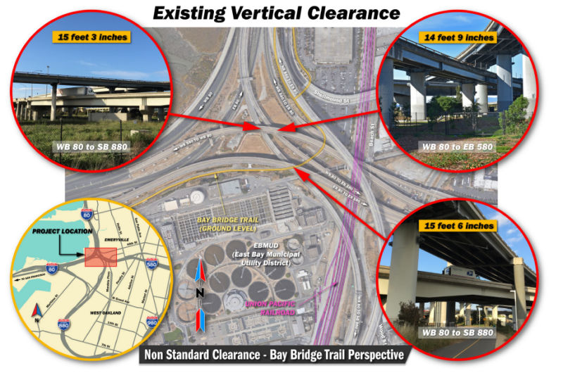 In March 2019, Caltrans started holding public hearings on the MacArthur Maze Vertical Clearance Project, whichwould to increase the vertical clearances at three locations within
the MacArthur Maze Interchange (MacArthur Maze or Maze) in the City of
Oakland, Alameda County. Two of the locations are along the connector from
westbound (WB) I-80 to southbound (SB) I-880, as it crosses below the WB
and eastbound (EB) I-580 overcrossings. The third location is along the
connector from WB I-80 to EB I-580 as it crosses below the connector from
WB I-580 to WB I-80. The existing vertical clearance at these three
locations does not meet the current Caltrans standard of 16 feet 6 inches
and impedes the safe and efficient movement of oversized vehicles and
loads through the Maze. The project is proposed to increase the vertical
clearance of the structures in the Maze to allow for more efficient travel
of oversized vehicles.
In March 2019, Caltrans started holding public hearings on the MacArthur Maze Vertical Clearance Project, whichwould to increase the vertical clearances at three locations within
the MacArthur Maze Interchange (MacArthur Maze or Maze) in the City of
Oakland, Alameda County. Two of the locations are along the connector from
westbound (WB) I-80 to southbound (SB) I-880, as it crosses below the WB
and eastbound (EB) I-580 overcrossings. The third location is along the
connector from WB I-80 to EB I-580 as it crosses below the connector from
WB I-580 to WB I-80. The existing vertical clearance at these three
locations does not meet the current Caltrans standard of 16 feet 6 inches
and impedes the safe and efficient movement of oversized vehicles and
loads through the Maze. The project is proposed to increase the vertical
clearance of the structures in the Maze to allow for more efficient travel
of oversized vehicles.
(Source: MacArthur Maze Vertical Clearance Project, Initial Study with Proposed Negative Declaration/Environmental Assessment, January 2019)
The alternatives are Alternative A: Bridge Lowering, Alternative B: Bridge Raising, Alternative C: Partial Bridge Replacement, Alternative D: Partial Deck Reconstruction, and the No-Build Alternative. The project proposes to increase the vertical clearances at three locations in the MacArthur Maze interchange to the current Caltrans standard of 16 feet 6 inches in order to allow for freight and oversized vehicles to travel through these major connectors. At present, the connector from WB I-80 to EB I-580 has 14 feet 9 inches of vertical clearance as it passes under the WB I-580 to WB I-80 connector. The connector from WB I-80 to SB I-880 has a vertical clearance of 15 feet 3 inches as it passes under the WB I-580 to WB I-80 connector, and a vertical clearance of 15 feet 6 inches as it passes under the EB I-80 to EB I-580 connector. Currently, The WB I-80 to SB I-880 connector is a two-lane freeway built in 1998 with 4-foot-wide left and right shoulders. The WB I580 to WB I-80 connector is a three-lane freeway built in 1935 and widened in 2006 with 3-footwide left and right shoulders. The EB I-80 to EB I-580 connector is a three-lane freeway built in 1955 and widened in 1962 with 2-foot-wide left and right shoulders.
In April 2019, it was reported that a Caltrans
plan to rebuild portions of the MacArthur Maze to accommodate larger
trucks has hit a roadblock in the form of angry local officials and
community groups who say the agency failed to tell them the project was
coming and performed only a cursory study of its potentially far-reaching
environmental effects. Caltrans announced in mid-April 2019 that it is
"pausing" its planning for the project, a decision that came after hearing
from Oakland and Emeryville officials and others who are questioning
whether the project is even necessary. Local communities say that
Caltrans' preliminary study of the project, which could lead to partial
closure of parts of the Maze and shunt traffic onto streets in Oakland and
Emeryville, fails to analyze a wide range of predictable impacts on
traffic, air quality, pedestrian and cyclist safety, and local businesses.
West Oakland, where Caltrans suggests many of the potentially detoured
vehicles would be routed, already suffers disproportionate pollution
impacts from highway, railroad and cargo ship traffic. Opponents note that
the agency, which has suggested that high-load trucks are being diverted
around the Maze to avoid the lower-than-standard overpasses there,
presented no data on how many trucks might be involved or evidence that
trucks have been striking the overpasses. The agency also conceded there
are no structural concerns with the Maze that would require the proposed
work. Neither the Port of Oakland nor the California Trucking Association
were aware of the project, and it was not something they asked for.
Further, the Caltrans proposal runs counter to a new state law, AB 617,
that has created a new plan for cleaning up an area of the city long
burdened by excessive pollution.
(Source: KQED, 4/24/2019)
 Naming
 Brown Freeway") The portion of this route between Route 5 and Route 205 (~ SJ 0.08 to ALA 0.317R) is named the "William
Elton 'Brownie' Brown Freeway" (signed as "W E "Brownie" Brown
Freeway". It was named by Assembly Concurrent Resolution 74,
Chapter 127, in 1985. William Elton "Brownie" Brown, (1912-1995), a
lifetime resident of Tracy, served for 6 years as the President of the
Highway 33 Association, and was instrumental in having I-5 located on the
far west side of the San Joaquin valley, thus saving valuable farm land.
The portion of this route between Route 5 and Route 205 (~ SJ 0.08 to ALA 0.317R) is named the "William
Elton 'Brownie' Brown Freeway" (signed as "W E "Brownie" Brown
Freeway". It was named by Assembly Concurrent Resolution 74,
Chapter 127, in 1985. William Elton "Brownie" Brown, (1912-1995), a
lifetime resident of Tracy, served for 6 years as the President of the
Highway 33 Association, and was instrumental in having I-5 located on the
far west side of the San Joaquin valley, thus saving valuable farm land.
(Image source: AARoads)
 The portion of this route from North Flynn Road in Livermore to Airway Boulevard (ALA 6.00 WB
to ALA 14.98 EB) is named the "CHP Officer John P. Miller Memorial
Highway" It was named in memory of California Highway Patrol (CHP)
Officer John Paul Miller. Born on January 29, 1975, to Larry and Caroline
Miller, in Stockton, California, Officer Miller graduated from Linden High
School in Linden, California, in 1994, and attended San Joaquin Delta
College in Stockton, California, where he was a respected athlete and
earned his Associate of Arts degree. Officer Miller was employed by
Cherokee Freight Line of Stockton as a mechanic and delivery driver prior
to becoming a California Highway Patrol Officer. Officer Miller was
married to his best friend, Stephanie Bianchi, on July 21, 2001, and had
two wonderful children, Chandler on March 18, 2003, and Reese on March 14,
2005. Officer Miller continued his education by attending California State
University, Sacramento and the University of Phoenix where he graduated
with a Bachelor of Arts degree in Business Administration in 2004. Officer
Miller entered the California Highway Patrol Academy on September 18,
2006, and upon graduation, was assigned to the Dublin Area Office in April
2007, serving the Dublin area for seven months. On November 16, 2007,
Officer Miller was killed in the line of duty while he was attempting to
apprehend a drunk driver in the Livermore Valley. As Officer Miller was
driving south on North Livermore Avenue, north of I-580, he was involved
in a patrol car collision causing fatal injuries. Named by Assembly
Concurrent Resolution (ACR) 78, Resolution Chapter 110, on 9/23/2009.
The portion of this route from North Flynn Road in Livermore to Airway Boulevard (ALA 6.00 WB
to ALA 14.98 EB) is named the "CHP Officer John P. Miller Memorial
Highway" It was named in memory of California Highway Patrol (CHP)
Officer John Paul Miller. Born on January 29, 1975, to Larry and Caroline
Miller, in Stockton, California, Officer Miller graduated from Linden High
School in Linden, California, in 1994, and attended San Joaquin Delta
College in Stockton, California, where he was a respected athlete and
earned his Associate of Arts degree. Officer Miller was employed by
Cherokee Freight Line of Stockton as a mechanic and delivery driver prior
to becoming a California Highway Patrol Officer. Officer Miller was
married to his best friend, Stephanie Bianchi, on July 21, 2001, and had
two wonderful children, Chandler on March 18, 2003, and Reese on March 14,
2005. Officer Miller continued his education by attending California State
University, Sacramento and the University of Phoenix where he graduated
with a Bachelor of Arts degree in Business Administration in 2004. Officer
Miller entered the California Highway Patrol Academy on September 18,
2006, and upon graduation, was assigned to the Dublin Area Office in April
2007, serving the Dublin area for seven months. On November 16, 2007,
Officer Miller was killed in the line of duty while he was attempting to
apprehend a drunk driver in the Livermore Valley. As Officer Miller was
driving south on North Livermore Avenue, north of I-580, he was involved
in a patrol car collision causing fatal injuries. Named by Assembly
Concurrent Resolution (ACR) 78, Resolution Chapter 110, on 9/23/2009.
(Image source: CHP Dublin on Facebook; Calif. Assn. of Highway Patrolmen)
 The portion of this route between Livermore and Castro Valley (~ ALA R8.197 to ALA R33.444) is named the "Arthur
H. Breed Jr. Freeway". Elected to both the California Assembly and
Senate between 1935 and 1959, Arthur J. Breed, Jr., was a tireless
advocate for the development of a high quality highway system in
California. This section was named by Senate Concurrent Resolution 5,
Chapter 73 in 1983.
The portion of this route between Livermore and Castro Valley (~ ALA R8.197 to ALA R33.444) is named the "Arthur
H. Breed Jr. Freeway". Elected to both the California Assembly and
Senate between 1935 and 1959, Arthur J. Breed, Jr., was a tireless
advocate for the development of a high quality highway system in
California. This section was named by Senate Concurrent Resolution 5,
Chapter 73 in 1983.
(Image source: Google Streetview; Online Archive of California)
 The portion of this route between East Castro Valley Boulevard and Strobridge Avenue (~ ALA R27.062
to ALA 30.37) is named the "Sergeant Daniel Sakai Memorial Highway".
It was named in memory of Daniel Sakai of Castro Valley. Born in April
1973, he grew up in Big Bear in San Bernardino County, where he developed
a love for everything outdoors. Daniel Sakai moved to the San Francisco
Bay Area to attend the University of California at Berkeley, where he
received a degree in 1996 in forestry and natural resources and also
worked as a community service officer. After graduating from the
university, Daniel Sakai spent a year in Japan teaching English. Daniel
Sakai attended the Oakland Police Department Academy, where he met his
soulmate and future wife, Jennifer. Daniel Sakai quickly rose to the rank
of sergeant of police and served the Oakland Police Department in various
roles, including as a patrol officer, canine handler, patrol rifle and
academy firearms instructor, and special weapons and tactics (SWAT) team
member. Daniel Sakai was described as a "special young man who was clearly
a born leader. He was committed to public service and making a difference
in other people's lives". He was also described as a "person that everyone
looked up to and wanted to be. He had the highest ethics". On March 21,
2009, Sergeant Daniel Sakai was killed, along with another SWAT team
member, Sergeant Ervin Romans, when the SWAT team attempted to apprehend a
suspect that had earlier in the day shot and killed Sergeant Mark Dunakin
and mortally wounded Officer John Hege, both of the Oakland Police
Department, during a traffic stop. Named by Assembly Concurrent Resolution
(ACR) 79, Resolution Chapter 111, on 9/23/2009.
The portion of this route between East Castro Valley Boulevard and Strobridge Avenue (~ ALA R27.062
to ALA 30.37) is named the "Sergeant Daniel Sakai Memorial Highway".
It was named in memory of Daniel Sakai of Castro Valley. Born in April
1973, he grew up in Big Bear in San Bernardino County, where he developed
a love for everything outdoors. Daniel Sakai moved to the San Francisco
Bay Area to attend the University of California at Berkeley, where he
received a degree in 1996 in forestry and natural resources and also
worked as a community service officer. After graduating from the
university, Daniel Sakai spent a year in Japan teaching English. Daniel
Sakai attended the Oakland Police Department Academy, where he met his
soulmate and future wife, Jennifer. Daniel Sakai quickly rose to the rank
of sergeant of police and served the Oakland Police Department in various
roles, including as a patrol officer, canine handler, patrol rifle and
academy firearms instructor, and special weapons and tactics (SWAT) team
member. Daniel Sakai was described as a "special young man who was clearly
a born leader. He was committed to public service and making a difference
in other people's lives". He was also described as a "person that everyone
looked up to and wanted to be. He had the highest ethics". On March 21,
2009, Sergeant Daniel Sakai was killed, along with another SWAT team
member, Sergeant Ervin Romans, when the SWAT team attempted to apprehend a
suspect that had earlier in the day shot and killed Sergeant Mark Dunakin
and mortally wounded Officer John Hege, both of the Oakland Police
Department, during a traffic stop. Named by Assembly Concurrent Resolution
(ACR) 79, Resolution Chapter 111, on 9/23/2009.
(Image source: East Bay Times; East Bay Times)
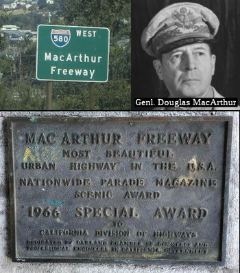 The portion of this route from Route 238 in Hayward/Castro Valley to the San
Francisco-Oakland Bay Bridge distribution structure (a/k/a "the Maze") in
Oakland (Route 80/Route 580/Route 880 interchange) (~ ALA R30.967 to ALA
46.487R) is named the "MacArthur Freeway". It is named for General
Douglas MacArthur of WW II and the Korean War, as well as for MacArthur
Boulevard which the freeway follows and was named for the general in the
1950's. It was named by Assembly Concurrent Resolution 27, Chapter 156, in
1968. Douglas MacArthur (1880-1964) was a brilliant and controversial
five-star U.S. Army General. Strongly dedicated to country and duty, and
gifted with superior command ability, MacArthur's military service
included important command assignments in the both World Wars and the
Korean War. During World War One, MacArthur commanded the 42nd "Rainbow"
Division of the Allied Expeditionary Force in France. After the War,
MacArthur was superintendant of West Point from 1919-1922. In January of
1930 he was promoted to full General, 4 stars and named the U.S. Army's
Chief of Staff. MacArthur retired from the Army in 1937, one year after
the President of the Phillipines, Manuel Quezon, appointed him Field
Marshall of the Phillipine Army. In 1941 MacArthur was recalled to active
duty as the U.S. prepared to enter World War Two. By 1942 MacArthur was
Supreme Allied Commander of the Southwest Pacific theater. In January of
1945, MacArthur was promoted to the rank of five star General. On
September 2, 1945 on board the USS Missouri in Tokyo Bay, MacArthur
accepted Japan's unconditional surrender. In June 1950, with the beginning
of the Korean War, MacArthur was appointed the Supreme United Nations
commander. However, on April 11, 1951 he was relieved of his command by
President Truman. This tunnel had been known as the "Presidio Tunnel".
The portion of this route from Route 238 in Hayward/Castro Valley to the San
Francisco-Oakland Bay Bridge distribution structure (a/k/a "the Maze") in
Oakland (Route 80/Route 580/Route 880 interchange) (~ ALA R30.967 to ALA
46.487R) is named the "MacArthur Freeway". It is named for General
Douglas MacArthur of WW II and the Korean War, as well as for MacArthur
Boulevard which the freeway follows and was named for the general in the
1950's. It was named by Assembly Concurrent Resolution 27, Chapter 156, in
1968. Douglas MacArthur (1880-1964) was a brilliant and controversial
five-star U.S. Army General. Strongly dedicated to country and duty, and
gifted with superior command ability, MacArthur's military service
included important command assignments in the both World Wars and the
Korean War. During World War One, MacArthur commanded the 42nd "Rainbow"
Division of the Allied Expeditionary Force in France. After the War,
MacArthur was superintendant of West Point from 1919-1922. In January of
1930 he was promoted to full General, 4 stars and named the U.S. Army's
Chief of Staff. MacArthur retired from the Army in 1937, one year after
the President of the Phillipines, Manuel Quezon, appointed him Field
Marshall of the Phillipine Army. In 1941 MacArthur was recalled to active
duty as the U.S. prepared to enter World War Two. By 1942 MacArthur was
Supreme Allied Commander of the Southwest Pacific theater. In January of
1945, MacArthur was promoted to the rank of five star General. On
September 2, 1945 on board the USS Missouri in Tokyo Bay, MacArthur
accepted Japan's unconditional surrender. In June 1950, with the beginning
of the Korean War, MacArthur was appointed the Supreme United Nations
commander. However, on April 11, 1951 he was relieved of his command by
President Truman. This tunnel had been known as the "Presidio Tunnel".
(Source: Information on General MacArthur from http://members.tripod.com/~DARTO/macarthur/macarthur.html; Image Source: Corco Highways; Biography.Com; Read the Plaque)
 Named Structures
 The Keller Avenue Bridge (Bridge 33-0340, ALA R037.80) that crosses I-580 in the City of Oakland is officially named the “Sergeant
Mark Dunakin, Sergeant Ervin Romans, and Officer John Hege Memorial
Bridge” (which is actually signed as the “Sergeant
Mark Dunakin, Sergeant Ervin Romans, Sergeant Daniel Sakai, and
Officer John Hege Memorial Bridge”, adding Sakai, who already
had a freeway segment named after him). According to the naming resolution, this structure was named in honor of Sergeant Mark Dunakin, Sergeant Ervin Romans, and Officer John
Hege, who proudly served the Oakland Police Department for 18 years, 13
years, and 10 years, respectively. Sergeant Dunakin began his career with
the department in May 1991. During his career, he was assigned to several
units of the department, including the Patrol Division, the Crime
Prevention Unit, the Robbery Section, and the Homicide Unit. In 1999,
Dunakin was promoted to the rank of Sergeant of Police. While serving in
the Homicide Unit, Dunakin acted as one of the lead investigators of the
"Nut Cases" gang, a group that terrorized Oakland in a 10-week crime wave
in 2002 and 2003. Dunakin's tireless work paid off when the gang was
successfully arrested. Sergeant Ervin Romans started his career with the
Oakland Police Department in 1996. Romans' sense of duty and commitment to
the department never wavered; in 1999, he received the Medal of Valor, the
department's highest honor, for evacuating endangered residents from a
fire in West Oakland. Romans' expertise and attention to detail served the
City of Oakland well when he become a Departmental Range Master, a
position in which he trained hundreds of officers in the ethical and
proper use of firearms and less lethal weapons. In 2005, Romans was
promoted to the rank of Sergeant of Police. As a sergeant, he supervised
one of Oakland's crime reduction teams and served as the entry team leader
on the department's Tactical Operations Team. Officer John Hege started
his career with the department as a volunteer reserve police officer in
1993. He was hired as a full-time police officer in 1999. Upon graduating
from the Oakland Police Academy, he was assigned to the Bureau of Field
Operations/ After patrolling the streets of Oakland for 10 years, Hege
fulfilled a lifelong dream when he was transferred to the Traffic
Operations Section and assigned as a motorcycle officer. Hege gave his
heart, soul, and a seemingly limitless amount of time to the Oakland
Police Department, yet he always made time for his family and friends.
Sergeant Dunakin, Sergeant Romans, and Officer Hege dedicated their lives
to the pursuit of safety and justice; and on March 21, 2009, Sergeant
Dunakin was shot and killed and Officer Hege was mortally wounded during a
traffic stop. Efforts to apprehend the suspect resulted in the death of
Sergeant Romans. Named by Assembly Concurrant Resolution (ACR) 146,
8/17/2010, Resolution Chapter 91.
The Keller Avenue Bridge (Bridge 33-0340, ALA R037.80) that crosses I-580 in the City of Oakland is officially named the “Sergeant
Mark Dunakin, Sergeant Ervin Romans, and Officer John Hege Memorial
Bridge” (which is actually signed as the “Sergeant
Mark Dunakin, Sergeant Ervin Romans, Sergeant Daniel Sakai, and
Officer John Hege Memorial Bridge”, adding Sakai, who already
had a freeway segment named after him). According to the naming resolution, this structure was named in honor of Sergeant Mark Dunakin, Sergeant Ervin Romans, and Officer John
Hege, who proudly served the Oakland Police Department for 18 years, 13
years, and 10 years, respectively. Sergeant Dunakin began his career with
the department in May 1991. During his career, he was assigned to several
units of the department, including the Patrol Division, the Crime
Prevention Unit, the Robbery Section, and the Homicide Unit. In 1999,
Dunakin was promoted to the rank of Sergeant of Police. While serving in
the Homicide Unit, Dunakin acted as one of the lead investigators of the
"Nut Cases" gang, a group that terrorized Oakland in a 10-week crime wave
in 2002 and 2003. Dunakin's tireless work paid off when the gang was
successfully arrested. Sergeant Ervin Romans started his career with the
Oakland Police Department in 1996. Romans' sense of duty and commitment to
the department never wavered; in 1999, he received the Medal of Valor, the
department's highest honor, for evacuating endangered residents from a
fire in West Oakland. Romans' expertise and attention to detail served the
City of Oakland well when he become a Departmental Range Master, a
position in which he trained hundreds of officers in the ethical and
proper use of firearms and less lethal weapons. In 2005, Romans was
promoted to the rank of Sergeant of Police. As a sergeant, he supervised
one of Oakland's crime reduction teams and served as the entry team leader
on the department's Tactical Operations Team. Officer John Hege started
his career with the department as a volunteer reserve police officer in
1993. He was hired as a full-time police officer in 1999. Upon graduating
from the Oakland Police Academy, he was assigned to the Bureau of Field
Operations/ After patrolling the streets of Oakland for 10 years, Hege
fulfilled a lifelong dream when he was transferred to the Traffic
Operations Section and assigned as a motorcycle officer. Hege gave his
heart, soul, and a seemingly limitless amount of time to the Oakland
Police Department, yet he always made time for his family and friends.
Sergeant Dunakin, Sergeant Romans, and Officer Hege dedicated their lives
to the pursuit of safety and justice; and on March 21, 2009, Sergeant
Dunakin was shot and killed and Officer Hege was mortally wounded during a
traffic stop. Efforts to apprehend the suspect resulted in the death of
Sergeant Romans. Named by Assembly Concurrant Resolution (ACR) 146,
8/17/2010, Resolution Chapter 91.
(Image source: KPIX 5; Daniel Michael Jennings: My Journey to Oakland)
Note: It appears the signmakers added Sgt. Daniel Sakai to the list of names on the sign, although it wasn't in the resolution. Sakai had the segment of I-580 between East Castro Valley Boulevard and Strobridge Avenue (~ ALA R27.062 to ALA 30.37) already named after him. It was named in memory of Daniel Sakai of Castro Valley. As noted in that resolution, Sakai was born in April 1973, and grew up in Big Bear in San Bernardino County, where he developed a love for everything outdoors. Daniel Sakai moved to the San Francisco Bay Area to attend the University of California at Berkeley, where he received a degree in 1996 in forestry and natural resources and also worked as a community service officer. After graduating from the university, Daniel Sakai spent a year in Japan teaching English. Daniel Sakai attended the Oakland Police Department Academy, where he met his soulmate and future wife, Jennifer. Daniel Sakai quickly rose to the rank of sergeant of police and served the Oakland Police Department in various roles, including as a patrol officer, canine handler, patrol rifle and academy firearms instructor, and special weapons and tactics (SWAT) team member. Daniel Sakai was described as a "special young man who was clearly a born leader. He was committed to public service and making a difference in other people's lives". He was also described as a "person that everyone looked up to and wanted to be. He had the highest ethics". On March 21, 2009, Sergeant Daniel Sakai was killed, along with another SWAT team member, Sergeant Ervin Romans, when the SWAT team attempted to apprehend a suspect that had earlier in the day shot and killed Sergeant Mark Dunakin and mortally wounded Officer John Hege, both of the Oakland Police Department, during a traffic stop.
 The I-580 overpass at 38th
Street in Oakland (actually, MacArthur Blvd Separation, Bridge 32-0281,
ALA 045.99) is named the "Officer James Williams Memorial Overpass".
This overpass is named in memory of Oakland Police Officer James Williams,
Jr., who died in the line of duty on January 10, 1999. The incident
started when a shotgun was discarded onto the freeway by suspects who were
fleeing from the police. Officer Williams was helping to locate the weapon
and was assisting in its recovery when a sniper began firing at the
responding officers from the southwest side of the 38th Avenue I-580
overpass in Oakland. Officer Williams was hit by the sniper's bullets and
died of those injuries. Officer Williams had a wife, Sabrina, and three
small children: ten-year-old Alexander, five-year-old Aaron, and
four-year-old Ariana. He was formerly a police officer in New Orleans, had
just graduated from the police academy and was still in training at the
time of his death. Named by Assembly Concurrent Resolution 82, Chapter 12,
filed 1/28/2000.
The I-580 overpass at 38th
Street in Oakland (actually, MacArthur Blvd Separation, Bridge 32-0281,
ALA 045.99) is named the "Officer James Williams Memorial Overpass".
This overpass is named in memory of Oakland Police Officer James Williams,
Jr., who died in the line of duty on January 10, 1999. The incident
started when a shotgun was discarded onto the freeway by suspects who were
fleeing from the police. Officer Williams was helping to locate the weapon
and was assisting in its recovery when a sniper began firing at the
responding officers from the southwest side of the 38th Avenue I-580
overpass in Oakland. Officer Williams was hit by the sniper's bullets and
died of those injuries. Officer Williams had a wife, Sabrina, and three
small children: ten-year-old Alexander, five-year-old Aaron, and
four-year-old Ariana. He was formerly a police officer in New Orleans, had
just graduated from the police academy and was still in training at the
time of his death. Named by Assembly Concurrent Resolution 82, Chapter 12,
filed 1/28/2000.
(Image source: SFGate)
 Other WWW Links
 Double Fine Zones
Although not specifically on Route 580, AB 348, Chaptered 9/21/2011 (Statute Chapter 290) designated (until January 1, 2017) the segment of county highway known as Vasco Road, between the Route 580 junction in Alameda County and the Walnut Boulevard intersection in Contra Costa County, as a Safety Enhancement-Double Fine Zone upon the approval of the boards of supervisors of Alameda County and Contra Costa County.
 Scenic Route
 National Trails
 This route is part of the De Anza National Historic Trail.
 This was part of the Lincoln Highway.
 This portion of this segment from I-80 (former US 50) to
I-205 was part of the coast-to-coast "Victory Highway".
This portion of this segment from I-80 (former US 50) to
I-205 was part of the coast-to-coast "Victory Highway".
 Interstate Submissions
Approved as chargeable Interstate on 7/7/1947, later adjusted in 1955 and 1957. In August 1957, this was tentatively approved as I-5W. In November 1957, the designation I-72 was proposed as part of the first attempt to give urban routes numbers (there were no 3-digit routes at the time). The proposal went back to I-5W in August 1958, and it was finally approved as I-5W, and later renumbered as I-580.
In August 1958, the designation I-580 was proposed by the department for what is now I-680.
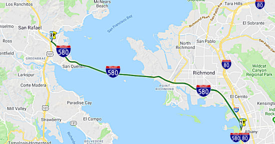 From Route 80 near Albany to Route 101 near San Rafael via the Richmond-San
Rafael Bridge.
From Route 80 near Albany to Route 101 near San Rafael via the Richmond-San
Rafael Bridge.
Post 1964 Signage HistoryIn 1984, Chapter 409 this segment was added by transfer from Route 17. The segment was originally submitted (1983) to have been I-180; however, state numbering rules changed it to be part of I-580. Before the transfer in 1984, the section from the junction of I-80 and I-580 ("MacArthur Freeway" or "the Maze") to the interchange at Hoffman Blvd (approximately 3 miles), was signed as I-80 and Route 17.
Before the completion of the freeway portion between the Hoffman Blvd/I-80 Interchange to the foot of the San Rafael Bridge, the Route 17 routing was as follows: Hoffman Blvd, to Cutting Blvd, to Standard Ave, and then to the foot of the Richmond-San Rafael bridge. This was signed as "Temporary I-580" until construction of the freeway I-580 was completed. Prior to 1959, this segment was part of LRN 69 between US 101 and US 40. It wasn't until 1959 that Route 17 was extended over the Richmond-San Rafael Bridge to meet US 101.
The Richmond-San Rafael Bridge is a double deck truss bridge spanning 5.5 miles with a maximum clearance of 185 feet. The Richmond-San Rafael Bridge connects Richmond in Contra Costa County and San Rafael in Marin County. Construction on the Richmond-San Rafael Bridge started in 1953 and was completed by 1956.
Pre 1964 Signage HistoryThe most recent freeway routing of I-580 appears to have been LRN 257, defined in 1959. A previous routing was LRN 69, and the San Pablo surface street routing was LRN 114. Both LRN 69 and LRN 114 were defined in 1933. This was cosigned US 40/US 50.
 In 1955, the CHC considered adoption of a freeway routing from the Eastshore Freeway
(US 40, Sign Route 17) in Albany to the approach to the Richmond-San
Rafael Bridge. This segment was a continuation of Sign Route 17, and would
be later renumbered as part of I-580. The plan calls for an 8-lane
freeway 5.8 mi in length from the El Cerrito Overhead near Golden Gate
Fields to the approach to the Richmond-San Rafael Bridge at Marine St.
There would be no change to the one-mile portion that lies in Albany.
In 1955, the CHC considered adoption of a freeway routing from the Eastshore Freeway
(US 40, Sign Route 17) in Albany to the approach to the Richmond-San
Rafael Bridge. This segment was a continuation of Sign Route 17, and would
be later renumbered as part of I-580. The plan calls for an 8-lane
freeway 5.8 mi in length from the El Cerrito Overhead near Golden Gate
Fields to the approach to the Richmond-San Rafael Bridge at Marine St.
There would be no change to the one-mile portion that lies in Albany.
(Source: Oakland Tribune, 1/27/1955 via Joel Windmiller, 2/16/2023)
StatusNote: I-580 is one of five routes in California that have "backwards" post miles (the others are Route 71, Route 153, Route 282, and I-780): that is, the postmiles go from East to West, instead of the normal West to East. This is an artifact of the original segment of the route being S to N, and then being expanded to an E to W route.
Richmond to Richmond-San Rafael Bridge
In October 2020, the CTC approved the following SHOPP
construction-related allocation: $15,652,000 for Contra Costa 04-CC-580 PM
0.9/1.5. PPNO 04-1482Q ProjID $10,800,000 EA 2J720. I-580 in Richmond, at
Stege Drain Bridge No. 28-0091. Outcome/Output: Replace
deteriorating bridge with a single span precast structure, reconstruct
shoulders and existing concrete barrier, and replace bridge approach
slabs. Con Eng $2,367,000; Const $10,800,000. (CEQA - CE, 10/8/2018;
Re-validation 6/19/2020) (NEPA - CE, 10/8/2018; Re-validation 6/19/2020)
(Source: October 2020 CTC Agenda, Agenda Item
2.5b.(1) #8)
In December 2011, the CTC authorized relinquishment of right of way in the city of Richmond along Route 580 on Marina Bay Parkway, consisting of collateral facilities. (04-CC-580-PM R2.9)
In August 2012, the CTC approved SHOPP funding of $18,459,000 on I-580 PM 5.5/6.1 near Richmond, at Scofield Avenue (Bridge #28-140L/R) and at Western Drive (Bridge #28-141R). Outcome/Output: Rehabilitate three bridges by replacing bridge decks to maintain structure integrity and reduce the risk to lives and properties.
In December 2019, it was reported that state Assemblyman Marc Levine has
started a new website — TheRichmondBridge.com — and social media campaign centered on replacing the 63-year-old
bridge. The site provides a forum for residents to voice their views and
submit suggestions. Terry Schanz, Levine’s chief of staff, said
while the planning efforts are in their nascent stages, it’s
important to get a head start on what will surely be a long and costly
process. “We shouldn’t be waiting until an unforeseen disaster
or another failure to start talking about a future bridge,” Schanz
said. Some topics Levine is seeking the public’s input on include
whether to increase vehicle traffic capacity, whether to include transit
amenities such as rail service or rapid bus lanes, installation of a
permanent pedestrian and bicycle lane and suggestions on the bridge
design. Maintenance of the bridge may reach nearly $900 million in the
next decade, Schanz said. Receiving input now will help inform Levine as
the state considers how it should spend its transportation dollars as
efficiently as possible, he said. Cost estimates on replacing the bridge
have varied, with Caltrans estimating an $8.2 billion price tag in a
recent proposal to the Metropolitan Transportation Commission.
(Source: $$ San Jose Mercury News, 12/4/2019)
Richmond-San Rafael Bridge (~ CC 6.235 to MRN 2.499)
In April 2013, it was reported that deck replacement was about to begin on the Richmond-San Rafael Bridge. The project will (a) Replace the concrete decks for three bridges; (b) refresh the eastbound and westbound Scofield Avenue Bridge Undercrossings; (c) refresh the Westbound Western Drive Bridge Undercrossing that approaches the Richmond-San Rafael Bridge Toll Plaza; (d) Strengthen structural steel bridge members; (e) Re-paint structural steel for corrosion protection; and (f) Replace bridge deck joints and seals.
Richmond-San Rafael Bridge - Third Lane
In September 2014, it was reported that BATA was
considering a proposal to restore a third lane to the Richmond-San Rafael
Bridge. Specifically, the BATA approved a contract with HNTB Corp. for up
to $3 million to provide design services regarding the third lane. A bike
path on the upper deck is also part of the design. Another lane would mean
more traffic flowing onto the 4.2-mile span, helping clear the congestion
on US 101 and Sir Francis Drake Boulevard. It would only be used for
eastbound vehicle traffic during evening peak periods. No construction
would be involved, because there were originally three lanes on each deck.
Caltrans closed one lane in each direction for emergencies and
maintenance. In the mid-1970s, the lane was used for a pipe that was
stretched across the bridge to carry water from Contra Costa to parched
Marin during the drought. The third lane idea has been discussed for
years, but something is finally happening thanks to the transportation
commission and the Transportation Authority of Marin. There are two
elements to the design project. One is to provide an additional travel
lane eastbound from the Sir Francis Drake onramp from San Quentin to the
Marine Street offramp in Richmond. This mostly involves converting the
right shoulder of the lower deck of the bridge to a lane . The second
element is more complicated, and would use the right-hand shoulder on the
upper deck for bidirectional bicyclist and pedestrian crossings. This
would require the installation of a movable median barrier. It also
requires developing a way to provide cyclists access from the east side of
the bridge.
(Source: Marin IJ, 9/21/2014)
In June 2015, it was reported that plans to add an
additional commuter lane and a bike-pedestrian path on the Richmond-San
Rafael Bridge are moving forward. The $74 million improvement project
would be fully funded with Bay Area Toll Authority toll funds. Right now,
the plan includes building a concrete barrier system on the upper deck of
the span for a bicycle and pedestrian pathway. On the lower deck, the
existing shoulder would be converted to a commuter lane, expected to
relieve traffic congestion during peak periods. In August 2015, it was
reported that Assembly Man Marc Levine believes that third eastbound lane
on the Richmond-San Rafael Bridge should be opened by the end of September
2015 at the latest, not in 2017 as Caltrans has proposed. He has
introduced a bill, AB9, in an attempt to push the agency into action.
Levine contends opening the third lane — which now is a shoulder
— is a simple fix: just paint in a new lane. The bridge initially
had three lanes when it opened in 1956, but when drought hit in 1977 a
lane was closed so a pipeline could be laid across the span to bring water
to Marin. When the pipeline was removed in 1978, the lane was converted to
a shoulder given light traffic. “The lane is there, they are just
pretending it’s a shoulder,” Levine said, adding the lane
could be opened on a “temporary” basis until a permanent fix
is achieved. Caltrans officials said simply painting in a new lane is not
as easy as it sounds. Caltrans noted the shoulder reduces in width from 10
feet on the bridge to just over 2 feet on land in Richmond, which would
create a bottleneck for cars. Caltrans also says the existing shoulder is
currently used as a bike path as it comes off the bridge. That use would
not be possible if the shoulder is widened for vehicle use. They are also
working over water, and now have to do the required environmental
planning. In October 2015, it was reported that the estimated completion
was October 2017.
(Source: KCBS, 6/24/2015, MarinI-J,
8/18/2015; SFGate, 10/31/2015)
On October 10, 2015, the Governor signed AB 157 (Chapter 393, Statues of 2015). This bill, if the CTC and Caltrans develop a project to open the third lane on the Richmond-San Rafael Bridge to automobile traffic on the eastbound level and to bicycle traffic on the westbound level, would authorize the lead agency to complete the design work for the project simultaneously with the environmental review conducted pursuant to the California Environmental Quality Act.
In July 2016, it was reported that a final design to
open a third eastbound lane on the Richmond-San Rafael Bridge to ease
traffic has gone to Caltrans, clearing the way for a projected December
2017 opening. In the coming years the bridge will undergo major changes
with the addition of a third vehicle travel lane on its lower deck and a
bike lane on top. The two projects have a $74 million price tag. A
contract for the project could be awarded as soon as September, with
construction starting in October. But issues with moving utilities could
cause delays. While opening the lane may sound simple, officials note a
state and federal rules environmental analysis is required. In addition,
new signs will have to go on the span and a retaining wall on the Contra
Costa side must be set back to create added space for cars heading off the
span. The added eastbound car lane would likely be open only during
commute hours, allowing Caltrans to retain a shoulder for maintenance work
during other times of the day. A second bridge project would bring a
10-foot-wide lane on the north side of the roadway on the top deck of the
span. Bicyclists and pedestrians traveling east and west would use the
space that would be separated from car traffic by a movable median
barrier. It would open in March 2018 under the current plan. A movable
barrier is needed to allow Caltrans to perform maintenance work on the
span. The bridge initially had three lanes when it opened in 1956, but
when drought hit in 1977 a lane on the top deck was closed so a pipeline
could be laid across the span to bring water to Marin. When the pipeline
was removed in 1978, the top and lower deck lanes were converted to
shoulders because of light traffic. The Richmond-San Rafael is the third
least-used of the Bay Area spans, ahead only of the Dumbarton and Antioch
bridges. But between 2011 and 2016, traffic has increased about 13 percent
as the economy has rebounded. The price tag for the lane is $30 million.
The bike path is $29 million, and there is a $15 million contingency. Once
built, the new configurations would be deemed a four-year pilot project
and would be analyzed after that time.
(Source: Marin I-J, 7/13/2016)
In August 2016, it was reported that state officials
finalized project approval and certified environmental documentation for
the $73 million project spearheaded by the Metropolitan Transportation
Commission (MTC), Caltrans, the Transportation Authority of Marin (TAM)
and the Contra Costa Transportation Authority (CCTA). State approval
clears the way for MTC this week to advertise a trio of construction
contracts and keeps the $73 million initiative on track to begin
construction this October, with the third eastbound lane slated to open in
October 2017. The third lane on eastbound I-580 will extend from the Sir
Francis Drake Blvd. on-ramp in Marin County to the Point Richmond exit in
Contra Costa County. Project elements include reconfiguring the Main
Street on-ramp from the San Quentin Village area of Marin County with a
retaining wall to improve the traffic merge with the new third eastbound
lane; replacing pavement on both the west and east sides of the bridge to
accommodate heavier traffic loads; relocating a retaining wall on the
south side of I-580 in Richmond to achieve safe sight distances for
vehicles traveling in the new right lane; constructing a barrier-separated
bicycle/pedestrian path on the north side of I-580 from Castro Street in
Richmond to Point Molate; and adapting the right shoulder of the westbound
Richmond-San Rafael Bridge deck for a bike/ped path that will become part
of the Bay Trail network. To separate bicyclists and pedestrians from
westbound traffic on the upper deck of the bridge, a moveable concrete
barrier will be installed on the span. This will allow Caltrans to conduct
bridge maintenance work during short closures of the path. The
10-foot-wide path will comply with Americans with Disabilities Act
standards.
(Source: Yahoo! Finance, 8/23/2016)
In September 2016, it was reported that a final design
to open a third eastbound lane on the Richmond-San Rafael Bridge has been
approved by Caltrans, clearing the way for a project to start once a
builder is found. In addition to a third vehicle travel lane on its lower
deck, a bike lane will go on top. The two projects have a $74 million
price tag. While opening the lane may sound simple, officials note a state
and federal rules environmental analysis is required. In addition, new
signs will have to go on the span and a retaining wall on the Contra Costa
side must be set back to create added space for cars heading off the span.
The added eastbound car lane would likely be open only during commute
hours, allowing Caltrans to retain a shoulder for maintenance work during
other times of the day. Other project elements in Marin include
reconfiguring the Main Street onramp from the San Quentin Village area
with a retaining wall to improve the traffic merge with the new lane, and
replacing pavement on the bridge approaches to accommodate heavier traffic
loads, according to officials. In later September, it was reported that a
key bay protection agency also gave its approval for the addition of an
eastbound, third traffic lane on the lower deck and a bike lane on the
upper deck of the span. The Bay Conservation and Development Commission
reviews all projects that are built in or over the bay and its approval
was needed to allow the commute relief plan to move forward.
(Source: Marin I-J, 9/6/2016, 9/17/2016)
In November 2016, it was reported that the Metropolitan
Transportation Commission’s Bay Area Toll Authority Oversight
Committee approved a $27.2 million contract to Berkeley-based O.C. Jones
and Sons Inc. in mid-November to construct the third lane and associated
work. It was one of five bids submitted. The committee also approved a
$5.6 million contingency fund to cover any changes in the work that may be
necessary. The third travel lane is slated for completion within 200
working days of the start of construction, likely Fall 2017.
(Source: Marin I-J, 11/11/2016)
In January 2017, it was reported that work on a project
to create a third eastbound lane on the Richmond-San Rafael Bridge to ease
traffic has started and could be finished by fall 2017. The Metropolitan
Transportation Commission approved a $27.2 million contract to
Berkeley-based O.C. Jones and Sons Inc. to construct the third lane and
associated work and that began the first week of January 2017. Early
phases of the project will include tree removal work near San Quentin, and
much of the initial work is occurring on the Contra Costa side, where a
retaining wall and a bike lane will be moved to accommodate the third
lane. Tree removal will also occur in that county as well. All trees will
be replaced. The added eastbound car lane only will be open during commute
hours, allowing Caltrans to retain a shoulder for maintenance work during
other times of the day. Other project elements in Marin include
reconfiguring the Main Street onramp from the San Quentin Village area
with a retaining wall to improve the traffic merge with the new lane, and
replacing pavement on the bridge approaches to accommodate heavier traffic
loads, according to officials. A second bridge project would bring a
10-foot-wide lane on the north side of the roadway on the upper deck of
the span. Bicyclists and pedestrians traveling east and west would use the
space that would be separated from car traffic by a movable median
barrier. The bike lane, a four-year experiment, will be separated from
traffic by a $25 million movable barrier like the one separating the
traffic lanes on the Golden Gate Bridge. That expensive movable barrier
comes with a $1 million mover. They’ll have to rev up the mover
every once in a while — to keep it in shape — and use it to
move the movable barrier, so it won’t get too stiff. A movable
barrier is needed to allow Caltrans to perform maintenance work on the
span. So, once a month, the 4.5-mile barrier will be shifted and then put
back in place, just to keep everything in working condition. It would open
in March 2018 under the current plan. January uncovered one additional
complication: Hummingbirds! A hummingbird nest was found on the Richmond
side of the project, in one of about two dozen trees that were to be
removed to widen the right-of-way on I-580, a half mile past the toll
plaza. Construction workers built a rough fence around the tree, and it
will stay in place until the egg they found in the nest hatches. The
bridge initially had three lanes when it opened in 1956, but when drought
hit in 1977 a lane on the top deck was closed so a pipeline could be
placed across the span to bring water to Marin. When the pipeline was
removed in 1978, the top and lower deck lanes were converted to shoulders
because of light traffic.
(Source: Marin I-J, 1/16/2017; SFChronicle,
1/30/2017)
In July 2017, it was reported that Commuters might have
to wait until March 2018 to see that third lane on the Richmond-San Rafael
Bridge open up. In January, the Metropolitan Transportation Commission
approved a $27.2 million contract with Berkeley-based O.C. Jones and Sons
Inc. to construct the third lane and associated work with a goal of
opening the lane by November. But one element of the work — pushing
a retaining wall on the Richmond side back 15 feet to create sight lines
for drivers in a third lane — is proving more difficult than
originally thought as crews carve away a hillside. The project is a lot
more than just restriping. Electrical work needed to hang signs over the
third lane has started. Signs will show a green arrow or red
“X” to indicate whether the lane is open. Once open, the added
eastbound car lane only will be available during commute hours, allowing
Caltrans to retain a shoulder for maintenance work during other times of
the day.
(Source: Mercury News, 7/11/2017)
In January 2018, it was reported that by April 2018,
drivers weary of the eastbound crawl to and across the Richmond-San Rafael
Bridge every evening should get relief with the addition of a new traffic
lane. But bicyclists, who were supposed to get their own path on the upper
deck at the same time, will have to wait, perhaps up to a year, and they
might have to surrender the path to cars for a few hours each weekday
morning. In 2015, the Bay Area Toll Authority, Caltrans and Marin and
Contra Costa transportation agencies agreed to a $74 million project that
would put the double-deck bridge’s wide shoulders to use. The lower
deck, which carries eastbound traffic, would get a third lane of traffic
while the upper deck would get a bike and pedestrian lane protected by a
barrier that would be movable to permit critical maintenance. The
additional lane for cars and trucks during peak afternoon and evening
commute times will open by April. The plan is to open the lane only from 2
to 7 p.m. each weekday, though operators in Caltrans’ Oakland
traffic control center will monitor cameras and lengthen the hours when
it’s appropriate. A red X or a green arrow will be displayed over
the lane to let drivers know when they can travel on it. For the time
being, construction crews are completing work on the lane, including
wiring and testing the network of cameras and inspecting cracks atop a
retaining wall above the Richmond end of the bridge. Traffic has swelled
by about 13 percent over the past five years, and backups have become
common, especially with eastbound traffic in the evening. Morning
congestion, heading west, has also worsened. So Marin transportation
officials went to regional planners in January 2018 to consider using the
movable barrier to transform the bike path to a car lane in the mornings
to ease the backup. The Toll Authority is still committed to opening both
the third lane and the bike lane. Both are experimental projects that have
to be evaluated after four years. While the third lane of traffic is
expected to open by April, the bike and pedestrian path is projected to
open late this year or in early 2019. But changes could come to the bike
path. The authority will study what it would cost, how much work would be
involved and how long it would take for a project in which bikes and cars
share the upper deck of the bridge.
(Source: SF Chronicle, 1/27/2018)
In March 2018, it was reported that the Bay Area Toll
Authority’s Oversight Committee authorized spending $100,000 to
study whether adding an additional WB traffic lane on the upper deck is
feasible and what it would take to accomplish the work. A third traffic
lane on the bridge on the bottom, eastbound deck, is set to open in April
2018 at a cost of $27 million. It’s designed to ease evening commute
traffic. A third lane on the north side of the upper deck coming into
Marin has been envisioned for bicyclists and pedestrians, separated from
car traffic by a movable median barrier. That work has just started.
However, Marin Supervisor Damon Connolly, who sits on the Metropolitan
Transportation Commission and the Bay Area Toll Authority — the
agencies behind the lane plan — said in January the space should
also be used for westbound vehicles.
(Source: Marin I-J, 3/9/2018)
In April 2018, it was reported that the long-awaited
eastbound third lane is planned to open April 20, 2018. Drivers still face
stop lights along Sir Francis Drake Boulevard on the way to the span, but
those signals have been modified to allow for better traffic flow. Marin
and other Bay Area voters will be asked to approve a phased $3 toll
increase in June 2018. Money from toll hikes would be earmarked to finance
transportation expansion projects, including a connector between
northbound US 101 and I-580 to the Richmond-San Rafael Bridge. But that
project is years away and it’s hoped by transportation officials
that the new traffic lane will provide some relief. The added lane will
likely be available from 2 to 7 p.m. every day of the week, allowing
Caltrans to retain a shoulder for maintenance work during other times of
the day. Twenty overhead signs on the span will show a green arrow or red
“X” to indicate whether the lane is open and a yellow
“X” and arrow during the transition. Cameras to watch traffic
on the span also have been added. Drivers should not be in the lane during
off hours and face citations from the California Highway Patrol if they
are caught.
(Source: East Bay Times, 4/16/2018)
In July 2018, it was reported that months before a
planned bikeway on the upper level of the Richmond-San Rafael Bridge is
scheduled to open, Bay Area transit officials and Marin County politicians
are talking about taking the separated bike lane away during peak demand
periods. Earlier in 2018, Marin County Supervisor Damon Connolly, who sits
on the Metropolitan Transportation Commission and the Bay Area Toll
Authority, brought up the possibility of converting the soon-to-be bikeway
— previously a highway shoulder — into another vehicle lane
during rush hour to help alleviate the hellish traffic congestion that
plagues the bridge. In early March 2018, the commission's Bay Area Toll
Authority Oversight Committee decided to study the idea and allocated
$100,000 to the task. The bike and pedestrian pathway, a piece of
infrastructure that cycling and walking advocates have anticipated for
decades, is the second part of a four-year pilot project run by the Bay
Area Toll Authority. The first phase of the pilot project was the addition
earlier in 2018 of a third lane of vehicular traffic on the lower-level
eastbound deck of the bridge. That project cost $53 million. The pilot
aims to assess possible strategies for improving the Bay Area's
transportation infrastructure. The 10-foot cycling-walking pathway is
still set to open in early 2019, and the study is analyzing a scenario
that would allow cyclists to continue using the bridge the majority of the
time. Still, the oversight committee's willingness to consider excluding
bicycles during commute hours worries some cycling advocates. They say
granting vehicles access to the lane — even if only during peak
commute times — interferes with the state-mandated project of a
trail around the San Francisco Bay. The westbound bikeway is projected to
cost about $28 million to install. The added car lane cost $53 million.
Legislation enacted nearly 30 years ago requires the Association of Bay
Area Governments to create and maintain a way for people to walk and ride
bicycles around San Francisco Bay. Now, the San Francisco Bay Trail is
mostly finished, with a few planned segments yet to be established. The
long-awaited pathway across the Richmond-San Rafael Bridge will form a
critical link in the trail.
(Source: East Bay Express, 7/11/2018)
In January 2019, it was reported that the Metropolitan
Transportation Commission, or MTC, and its associated Bay Area Toll
Authority intended for the new pedestrian-bike lane on the upper deck of
the bridge to be a four-year pilot project. But the Transportation
Authority of Marin is seeking to cut that trial period down to six months.
Once the westbound bike lane opens, the Transportation Authority of Marin
is requesting Caltrans and the toll authority collect data on how much it
is used. The idea would be to open up the new bike lane to vehicle traffic
only during the morning commute hours and then revert it back to a
bike-pedestrian only path the rest of the day. The Transportation
Authority of Marin states in its staff report that daily westbound traffic
demand on the bridge has risen from 68,000 cars in 2013 to the current
82,000 cars. Peak delays in the morning commute are around 22 minutes or
more, with that number expected to increase to at least 27 minutes by
2020, according to the authority. The authority states in a draft letter
to the Bay Area Toll Authority that this increased congestion risks
undermining its investments and plans to promote carpool, vanpools and
other transit if a third lane is not added. In 2018, the MTC and Bay Area
Toll Authority opened a third lane for eastbound commuters meant to
relieve afternoon traffic congestion, which has been a great success.
Westbound commuters have been calling for the same relief for some time.
For westbound traffic, the emergency pullover lane is being converted to a
bike and pedestrian path with a moveable barrier similar to that used on
the Golden Gate Bridge. Work is ongoing by Caltrans and nearby agencies to
accommodate this change. The project is expected to cost about $25
million, which is paid for using Bay Area Toll Authority toll bridge
funds.
(Source: Marin I-J, 1/22/2019)
In February 2019, it was reported that the falling
concrete on the Richmond-San Rafael Bridge will delay opening the
bicycle/pedestrian path. Contractors currently working on repairs to
Richmond-San Rafael Bridge as a result of the falling concrete will remain
for several months to make additional replacements to joints on the
span’s upper deck. The added work means the opening of a
bicycle/pedestrian path set for late spring will be delayed by at least
two months, according to Caltrans. As of mid-February, crews were
replacing the upper deck expansion joint responsible for the falling
concrete and expect work to be finished by March 2. When that’s
done, nearly identical work on 31 additional upper deck joints will start
on March 4. To allow construction crews unfettered access to the joint
repair sites, the installation of a four-mile long moveable barrier to
separate bicyclists and pedestrians from auto traffic has been delayed.
Once the barrier is installed, the bicycle/pedestrian path will follow in
three to four weeks, Caltrans officials said. Inclement weather could
extend the schedule of repairs.
(Source: Napa Valley Register, 2/23/2019)
In October 2019, it was reported that crews were
starting construction to install the moveable concrete barrier that will
separate the two westbound traffic lanes on the upper deck of the
Richmond-San Rafael Bridge from a new bicycle/pedestrian path expected to
open later in Fall 2019. The four-mile-long bridge path will connect to
another new bicycle/pedestrian path that runs along the north side of
I-580 in Richmond and is protected from freeway traffic by a permanent
concrete barrier. Together, these bi-directional paths stretch for almost
six miles from Castro Street in Richmond to East Francisco Blvd. in San
Rafael, providing the first-ever route for bicyclists and pedestrians
traveling between Marin County and the East Bay. These new paths are a key
link in the planned 500-mile Bay Trail network. Both the Richmond-San
Rafael Bridge barrier and a barrier-transfer machine (also known as a
"zipper truck") were manufactured by, and will be installed by, Lindsay
Transportation Solutions of Rio Vista, which also built and installed the
roughly 2.5-mile-long moveable median barrier on the Golden Gate Bridge.
Though conceptually similar to the 32-inch-tall Golden Gate Bridge
barrier, each of the 3.28-foot-long segments of the Richmond-San Rafael
Bridge barrier features a plastic attachment that raises its height to 42
inches to meet published standards for bicycle safety railings. The
individual barrier sections weigh 1,575 pounds and feature rubber feet to
prevent water from pooling at the barrier's base and to prevent damage to
the concrete bridge deck. Once the barrier is fully installed, trained
crews using the "zipper truck" will be able to quickly reposition it as
necessary to allow crews working for Caltrans and the Bay Area Toll
Authority (BATA) to complete bridge maintenance tasks during short
closures of the bike/ped path. Performance of the new bike/ped path will
be monitored and assessed continually as hard data becomes available on
the use of the path by bicyclists and pedestrians, and operational
adjustments will be made as needed. This evaluation will include a
before-and-after study conducted by Caltrans and the University of
California's Partners for Advanced Transportation Technology (PATH)
program. BATA and Caltrans are now conducting a study of the bridge's load
rating to evaluate the span's structural capacity for both current and
future conditions. This study is slated for completion in the spring of
2020 and will include analysis of three westbound traffic lanes with the
moveable barrier on the upper deck. TAM also has begun working on a
corridor traffic analysis to identify improvements that may be needed on
the Marin County side of the bridge to accommodate three lanes of
westbound traffic across the span.
(Source: PR News Wire/BATA, 10/1/2019)
In November 2019, it was reported that the new bike and
pedestrian path on the Richmond-San Rafael Bridge has opened to the
public. It’s 8 feet wide and 4 miles long, and it leads, depending
on your point of view, either directly into the future, or directly to a
grim prison on one side or to a pungent oil refinery on the other. The
path was six years in the planning. It is a four-year “test
project” to see if enough non-motorists use it. Motorists
haven’t given up on dreams of their own to turn the bike lane into a
third lane of traffic on the westbound upper deck, to go along with the
new third traffic lane on the eastbound lower deck. Previously, the decks
had two traffic lanes and one breakdown lane in each direction. Whether
cyclists keep showing up will be closely watched by the Metropolitan
Transportation Commission and others who will decide on the path’s
fate. The new path, with a blue line running down the middle, is separated
from the two westbound traffic lanes by a row of gray traffic barriers.
Getting across can take some doing. Wind and fog can challenge cyclists,
and the undulating path requires them to climb from water level to heights
of 185 and 135 feet. From either of the bike path’s end points near
the Chevron refinery on the east and San Quentin prison on the west,
considerably more pedaling is required to reach such traditional cycling
hot spots as a park, a bakery or a coffee bar.
(Source: SF Chronicle, 11/17/2019)
In May 2021, it was reported that a new burst of $4.3
million infusion in state funding will improve the Richmond-San Rafael
bike path. When completed in November 2019, the Bay Area’s first
transbay bike path led cyclists from the bridge onto Marin roads with
little or no developed bicycle lanes, posing a potential risk of a vehicle
collision. This latest project by local and state agencies would extend an
existing 10-foot-wide sidewalk on Francisco Boulevard East in San Rafael
from the western end of the bridge bike path and connect cyclists to
existing bike lanes into downtown San Rafael. Specifically, in May 2021
the Metropolitan Transportation Commission voted unanimously to approve
$4.3 million in state grant funds to extend the sidewalk another
quarter-mile to Grange Avenue. From there, cyclists can cross the street
to an already-completed bike lane along the westbound Interstate 580
flyover that takes them to Andersen Drive, leading into downtown San
Rafael or to Sir Francis Drake Boulevard toward Larkspur. The project also
includes a crossing beacon with flashing lights to warn drivers of
cyclists and pedestrians crossing Francisco Boulevard East to the flyover
bike path. The California Transportation Commission must give final
approval to the funds. If approved, construction could begin by the fall
and be completed before the end of the year. The total cost of the project
is about $5.6 million, of which the remaining $1.3 million will be covered
by the Metropolitan Transportation Commission.
(Source: Marin I-J, 5/3/2021)
In September 2021, it was reported that Marin
County’s efforts to avoid running out of water by building a
pipeline across the Richmond-San Rafael bridge are adding new
complications to several bridge projects already years in the making,
including the bicycle pathway and the potential for a third westbound
commuter lane. Marin Municipal Water District is proposing to build an up
to $90 million, 8-mile pipeline over the bridge from Richmond into Marin
that could pump in water purchased from Sacramento Valley agricultural
producers. Design options being studied by Caltrans include either
strapping the pipeline underneath the top deck of the bridge or laying it
along the shoulder of the top deck where the bicycle and pedestrian path
has resided since late 2019. There are also conversations underway about
whether to make the pipeline a permanent feature of the bridge to be used
for future droughts. A pipeline was installed on the top deck in 1977 when
the county last faced a water shortage. The pipeline was removed in 1982
at the request of Caltrans to restore traffic to the blocked third lane.
The Transportation Authority of Marin — the county’s traffic
congestion management agency — has been studying several projects
aimed at addressing traffic flow on the bridge. These include potentially
closing the bike path during peak morning commute hours on weekdays from 5
a.m. to 11 a.m. to allow for a third lane of vehicle traffic into Marin.
But the possible addition of a 24-inch diameter pipeline along the bike
path as soon as summer 2022, especially if it were permanent, has raised
questions. In a letter to the district, TAM Executive Director Anne
Richman called on water district leaders to select a pipeline
configuration that provides the “maximum flexibility for future
transportation uses of the bridge.” Water district staff said they
were working with Caltrans to review two configurations of the pipeline to
develop a preferred option. Water district Operations Director Paul
Sellier said analyses of the bridge have found it can support the pipeline
in its current state, including with the existing moveable barrier along
the bike path. The question now is where the pipeline would be built. One
option would be to have the pipeline run underneath the top deck of the
bridge. The pipeline would need to be at least 16.5-feet above the
eastbound traffic below, which Sellier said could be achieved throughout
the entire span. Should the water district choose the bike path route, the
pipeline could result in an up to 10-inch incursion into the 10-foot wide
pathway, Sellier said. Another complication is the vehicle that is used to
slide the moveable concrete barrier along the bike path is wide enough
that it occupies part of the space where the pipe would be located,
Sellier said. Also of concern is the Transportation Authority of
Marin’s study into whether to close the bike lane during weekday
morning commute hours. Opening the third upper deck lane to traffic would
require bridge improvements on the Marin end ranging from $70 million to
$90 million, according to the transportation authority. This project would
include widening portions of the bridge relocating the Francisco Boulevard
on-ramp and widening portions of I-580.
(Source: Marin I-J, 9/24/2021)
In April 2023, it was reported that Marin’s
representative in the state Assembly has authored a bill calling for
transportation agencies to consider reopening a third westbound lane on
the Richmond-San Rafael Bridge during the weekday morning commute. The
bill introduced by Damon Connolly, a Democrat from San Rafael, also
requests that the California Department of Transportation and the Bay Area
Toll Authority evaluate adding an eastbound moveable barrier so that a
bicycle and pedestrian lane can be maintained at all times. The proposed
legislation, AB1464, passed with unanimous, bipartisan support out of the
Assembly Transportation Committee, and moved to the Assembly’s
Appropriations Committee. The bill would not require a project to be
undertaken; current law prohibits the Legislature from enacting
legislation that contains specific individual transportation projects. It
does, however, lay out a case for reopening a third westbound lane during
the morning commute. The bill states that traffic on the East Bay approach
of the Richmond-San Rafael Bridge has steadily worsened, even during the
COVID-19 pandemic.
(Source: Marin I-J, 4/19/2023)
In July 2023, it was reported that a four-year program
set to conclude in November will determine the worthiness of a bike and
pedestrian pathway that eliminated a traffic lane on the Richmond-San
Rafael Bridge in the Bay Area. The bicycle and pedestrian path across the
Richmond-San Rafael Bridge cost taxpayers $20 million. Since the pathway's
opening in 2019, it has been severely underutilized, with only 281,000
bikes having used the bridge. In early Summer 2023, 139 bikes cross each
weekday, and 434 bikes cross on weekends. The highest number to have
crossed the bridge was last July last year, with 747 bikes. Even fewer
people walk along the bridge, with only 35,000 utilizing that part of the
San Francisco Bay Trail. Roughly 23 people walk across the Richmond-San
Rafael Bridge on weekdays, and 39 people on weekends. The highest number
of pedestrians recorded to have crossed the bridge in a single day was on
April 25th, with 1,688 people. The Bay Area Council, along with Richmond
officials and neighborhood groups, point to the adverse health impact of
this situation. One proposed solution is to temporarily close the
pedestrian and bike path on the westbound side during the morning commute.
This route would be open to traffic until the commute is over. The
moveable divider could be moved to the side, similar to what happens on
the Golden Gate Bridge during commute hours.
(Source: KTVU 2, 7/17/2023)
In November 2023 it was reported that the four-year
trial run of a bicycle and pedestrian path on the Richmond-San Rafael
bridge comes to an end at the close of November 2023. Before
transportation officials can decide whether the path will reopen, they
have to await the results of a pilot study final report. The $20 million
path opened four years ago. The controversial pilot project converted the
bridge’s westbound emergency and maintenance lane into a path that
is separated from vehicle traffic by a moveable barrier. Cyclists said the
path project has fulfilled a decades-old vision to create the first route
connecting the North Bay and East Bay. Critics, including East Bay
residents and the Bay Area Council business association, say the path
should be opened up to vehicles during the mornings to provide relief to
the tens of thousands of commuters stuck in traffic as opposed to a
handful of weekday cyclists. Over 2023, an average of 115 cyclists use the
path on weekdays and an average of 325 cyclists on the weekends, according
to commission. The weekday pedestrian average is 15, while the weekend
average is 30. By comparison, more than 80,000 vehicles cross the 5.5-mile
bridge on weekdays. Westbound drivers can experience delays of nearly half
an hour during peak commute times.
(Source: $ Marin I-J, 11/5/2023)
In February 2024, it was reported that Bay Area
transportation planners were exploring what it would take to open the
westbound shoulder of the Richmond-San Rafael Bridge for commuter traffic.
The emergency and maintenance lane on the bridge’s upper deck was
converted into a bicycle and pedestrian path that is protected by a
moveable barrier in 2019 for a four-year trial period. The controversial
path remains open pending a final report that could determine the fate of
the test project. Critics, mostly commuters and their employers, say
traffic is worse than ever, while supporters maintain the path is a
successful multimodal connection between the North Bay and the East Bay.
In March, MTC staffers will be presenting a proposed scope, schedule and
cost for preparation of a “design alternatives study” that
would include opening the shoulder as a bus and carpool lane during peak
hours. According to a 2021 study, it would cost about $1 million annually
to move the barrier twice a day during weekdays to allow vehicular traffic
during peak hours. A machine capable of doing the job would cost $1.27
million. The installation of the barrier was $12 million. The cost of
removal is unknown. Adding a third westbound lane would reduce travel
times by 11 minutes for drivers headed toward northbound US 101. However,
drivers traveling to southbound US 101 would be delayed by three minutes.
The 2021 report said it would cost between $70 million to $90 million to
reconfigure the western side of the bridge in San Rafael to handle the new
traffic flow. Any such projects would require overcoming environmental
hurdles lasting several years. MTC and Caltrans are also pursuing a suite
of projects — dubbed “Richmond-San Rafael Forward”
— that were conceived to shave up to 17 minutes off the westbound
morning commute into Marin County. One of the projects is to remove the
toll booths to make way for open-road tolling and an extended carpool lane
at an estimated cost of $24 million. That project is expected to open in
the winter of 2026. Other near-term projects include a $5 million Richmond
Parkway interchange, transit improvements and more bicycle infrastructure
improvements.
(Source: Marin I-J, 2/4/2024)
Richmond-San Rafael Bridge - Concrete Chunks
In February 2019, the Richmond-San Rafael Bridge over
San Francisco Bay was shut down in both directions after football-sized
chunks of concrete fell from the upper deck of the bridge onto the lower
deck, authorities said. A driver called 911 around 10:30 a.m. on 2/6/2019
to report that pieces of concrete had struck a car, California Highway
Patrol Officer Andrew Barclay said. The driver said the vehicle was
damaged, but the traveler was on the way to the airport and kept on
driving, Barclay said. Traffic was stopped in both directions after CHP
officers saw that vibrations from vehicles on the upper deck were causing
more chunks of concrete to fall onto the roadway below. It was likely that
wear-and-tear caused the concrete to crack. The cracking occurred near an
expansion joint that dates back to the bridge’s original 1956
construction. A heavy truck passing over the joint might have crushed the
brittle and aged concrete near the antiquated joint, according to Caltrans
District 4. Historically, there have been repeated problems with expansion
and deck joints on the Richmond bridge, as well as other bridges with
similar joints, said Andrew Fremier, the deputy executive director of
operations for the Bay Area Toll Authority, which works with Caltrans to
oversee maintenance of the Bay Area’s state-owned toll bridges.
Holes popping up on the bridge prompted $50 million in emergency repairs
in 2004, work that was added to the $795 million seismic retrofit, which
included replacing 63 concrete deck sections and 700 expansion joints. In
early 2006, just four months after the 2005 retrofit work was deemed
complete, more holes in the concrete cropped up near joints on the bridge,
prompting an additional $25 million in repairs. In the last five years,
the toll authority has shelled out $46 million for various projects on the
bridge, mostly joint repairs and painting, said John Goodwin, a spokesman
for the authority. It’s also planning another $80 million in ongoing
maintenance and replacement of the joints, along with other work, over the
next 10 years. In the short term, Caltrans crews placed steel plates over
the affected area, with plywood boards below the deck, to allow motorists
to drive over the concrete without more pieces shaking loose and crashing
onto the cars and trucks below. The concrete itself varies in thickness
throughout the span but can be up to 10 inches-thick. It has a 3/4- to
one-inch-thick protective coating that is periodically ground off and
replaced. The coating is more durable than the concrete below and has
grooves on it to provide better skid resistance and tire adhesion. Below
the surface, however, sections of the concrete dates back to the original
construction. It’s lightweight concrete, which makes it more prone
to breaking off in small chunks.
(Source: LA Times, 2/7/2019; EastBy
Times, 2/8/2019)
In later February, it was reported that permanent
repairs to the bridge joint were delayed. Caltrans engineers made
emergency fixes to an expandable joint on the bridge’s upper
westbound deck to reopen all lanes Thursday evening. They decided
overnight Saturday to swap out a temporary metal plate acting as a patch
with a larger one to make for a smoother ride over the tolled east-west
connector. Replacement of the joint — which expands or contracts
from varying temperatures and weight loads — to ensure more chunks
of concrete don’t break off was set to begin early this week. With
heavy rain and strong winds expected, that work won’t start until at
least Feb. 18. 2019. The anomaly was not cause for additional concern,
according to the Bay Area Toll Authority, nor should there be worries
among its daily 82,000 motorists about the bridge’s structural
safety. The critical link between Marin and Contra Costa counties had an
almost $800 million seismic retrofit in 2005, as well as a $74 million
expansion to add a third lane on the lower deck that opened last year. In
addition, the Bay Area Toll Authority spent $46 million on maintenance,
including repair or replacement of some of the other hundreds of
expandable joints, over the past five years. In the next decade, another
$80 million is budgeted for similar work.
(Source: Press Democrat, 2/11/2019)
There is a bit more insight on the underlying cause of
the concrete chunks from Abolhassan Astaneh-Asl, a UC Berkeley professor
emeritus of civil engineering. Astaneh-Asl served on an advisory board for
the 2005 seismic retrofit of the Richmond-San Rafael Bridge and said the
concrete fell from an expansion joint above the lower deck. As the bridge
is not a single continuous slab, it is held together every 100 feet or so
by an expansion joint. These expansion joints expand and contract as
temperatures rise and fall, but also receive the most wear and tear from
vehicles, he said. “What damages the bridges are loads of trucks.
When trucks are driving over the bridge and get to the expansion joint
from one slab to the other slab, that impact causes stresses on the
deck,” he said. As one of the leading engineering experts on steel,
Astaneh-Asl also investigated the World Trade Center site after 9/11. The
older lightweight concrete used at the World Trade Center was brittle and
similar to the type used for the Richmond-San Rafael Bridge back in the
1950s. While lightweight concrete on the bridge’s upper deck puts
less stress on the structure, it is also extremely fragile. Public highway
bridges must be routinely inspected at least every 24 months for wear and
tear, according to Federal Highway Administration spokesperson Nancy
Singer. “Before this thing broke, there must have been some
cracks,” Astaneh-Asl said. “If an inspector says the expansion
joints need repair or replacement, this should have been
prioritized.” An inspection last August found no flaws with the
expansion joint responsible for dropping concrete, according to Caltrans.
(Source: Golden Gate Express, 2/19/2019)
In February 2019, it was reported that more than 60
joints like the one that failed earlier in February 2019 on the
Richmond-San Rafael Bridge will soon have to be replaced at a cost of more
than $10 million. The $300,000 repair work on that failed joint has been
completed as of late February 2019. Now, the plan is to replace the 30
remaining joints on the upper deck, followed by the 31 on the lower deck.
The joint replacement work is being done as part of a $20 million fund
that had been aside for targeted maintenance on the aging span, now more
than six decades old. The bulk of 800 joints on the 5.5 mile bridge have
already been retrofitted under work that was performed back in 2005. At
that time, the bridge’s steel-to-steel joints were not considered at
risk. Then in August 2018, Caltrans maintenance crews were dispatched to
look at the underside of the upper deck after reports of loud banging and
clanging noises at the spot where the joint ultimately failed. The type of
joint is known as a steel to steel connection because it relies on two
overlapping steel plates embedded into the end of concrete road deck
sections with steel studs. The joints are designed to handle heat
expansion and contraction between deck sections but apparently became
undermined under the pounding inflicted by heavy trucks.
(Source: NBC Bay Area, 2/22/2019)
In March 2019, it was reported the joint repair was
proceeding on the Richmond-San Rafael Bridge after chunks of concrete
hadfallen from an expansion joint. Officials blamed the mishap on a
cracked expansion joint — one of the 36-foot steel bars that link
sections of thebridge and allow it to move when the temperature changes.
Sixty-one such bars on the bridge’s truss section date to the 1950s;
Caltrans didn’ttouch them during a seismic retrofit in the
mid-2000s, during which officials replaced 795 other joints. But after
February’s concrete shower, and thenine-hour shutdown that followed,
officials decided that the remaining joints had to be replaced. Craters
and gashes in the roadway are a fairly commonoccurrence on the bridge,
including some large enough to view the water below. The span, completed
in 1956, has a thin deck that suffers constant batteringfrom cars and
trucks.
(Source: SF Chronicle, 3/20/2019)
In April 2019, it was reported that state
transportation agencies are set to kick off a $300,000 study next week to
analyze the condition of the bridge decks. The study will be one part of a
larger assessment headed by the Bay Area Toll Authority and Caltrans of
several of the Bay Area’s state-owned bridges. The Richmond-San
Rafael Bridge will be first in line following recent incidents of concrete
falling from the upper deck. As part of the study, Colorado-based Bridge
Diagnostics and Massachusetts-based Infrasense will use various
technological surveying tools such as radar to penetrate deep into the
bridge decks without damaging them. They will search for signs of
degradation, cracking and more. The overall Richmond-San Rafael Bridge
assessment is expected to cost about $800,000, which includes the deck
condition study, and will be funded by toll revenue, Goodwin said. The
completion date is set for March 2020. While the bridge has about $80
million in planned maintenance over the next decade, there isn’t
funding planned beyond then, especially for a full deck replacement. The
cost of replacing the decks could run into the hundreds of millions of
dollars.
(Source: Mercury-News, 4/20/2019)
In April 2019, it was announced that the Metropolitan
Transportation Commission has announced that each of the original joints
on the Richmond-San Rafael Bridge will be replaced with new joints. The
original 31 joints were installed in the mid-1950s. To avoid cracking on
the upper deck, the new joints will shrink and expand as the weather
changes with a rubber seal, according to officials. Crews expect to have
all joints replaced on the upper deck in July 2019.
(Source: KRON 4, 4/29/2019)
In July 2019, it was reported that the inital phase of
repairs on the Richmond-San Rafael Bridge (i.e., the joints on the upper
deck) was completed. Opened in 1956, the bridge utilizes two decks to
carry traffic across I-580 and connects San Rafael in the west to Richmond
in the east. Commuters using the toll bridge were more than a bit upset on
the morning of Feb. 7 when pieces of concrete, some as big as footballs,
fell onto the lower deck of the structure. Some motorists were so agitated
that they turned their vehicles around and drove against the traffic to
get off the bridge. Experts quickly determined that spalling —
concrete that flakes or breaks up, most likely due to the bridge's age and
the Bay Area's often harsh weather — had caused the deterioration
along an expansion joint near the bridge's eastern end. Other likely
factors include the constant vibration and wear-and-tear on the grizzled
old bridge. Each of the probable causes for this incident has done damage
to the Richmond-San Rafael structure before. Shortly after the February
accident, Caltrans announced that crews would immediately begin replacing
a total of 31 joints on the upper deck of the structure, with a mid-summer
completion, before replacing another 30 joints on the lower deck later in
the year. According to Vince Jacala, a public affairs officer for Caltrans
in nearby Oakland, contractors were dispatched to the site to perform a
temporary joint repair, while also starting an emergency project to
replace the broken bridge joint entirely. Rainy weather in late February
and into March, though, delayed the start of concrete work on the
Richmond-San Rafael bridge, but crews were able to make up for lost time
and have stayed on track to finish the construction in July, as originally
planned. O.C. Jones & Sons, the respected engineering contracting firm
based in Berkeley, was chosen to make the needed fixes on the bridge, with
Bridgeway Civil Contractors in Vacaville working as the subcontractor. For
the emergency fix, an average of three full crews are working to install
and weld the new joints onto the bridge. Light towers also are on hand to
allow them to do their nighttime work, ably assisted by Kubota SSV75 skid
steers to haul materials to where they're needed. Jacala estimated the
contract for the joint replacements and repairs to be $8.3 million. The
sliding plate joints are made up of a large "C" channel cast into each
side of the concrete deck joint with a steel plate welded to the top of
one of the "C" channels. These joints are designed for thermal expansion
and contraction — a key engineering feature for any bridge in San
Francisco Bay where winds and temperature changes are capricious.
(Source: Construction Equipment Guide, 7/2/2019)
After the last joint was replaced, there was still some
work remaining. Rubber seals required placement on the last remaining
joints. Sometime in 2020 crews will replace 30 of 31 joints on the lower
deck, along with the surrounding concrete, as part of a larger
rehabilitation project that will include painting and other work. That
project has not yet been put out to bid and is expected to take three to
five years.
(Source: Mercury News $$$, 7/17/2019)
In August 2019, it was reported that Caltrans has
completed joint replacement work on the Richmond-San Raphael Bridge, more
than six months after chunks of the aging structure fell into traffic.
Each of the 31 joints that date back to the 1950s has been replaced by a
new concrete joint with a rubberized seal designed to shrink and expand
with changing temperatures, according to Caltrans officials. The new
joints should prevent cracking of the surrounding concrete road deck. Next
year, Caltrans will replace 30 joints on the lower deck of the bridge in
conjunction with a bridge painting contract.
(Source: Local News Matters, 8/21/2019)
Richmond-San Rafael Bridge Makeover/Lower Deck Joints
In August 2019, it was reported that the Richmond-San
Rafael Bridge is set to get an $85 million makeover in 2020 with the help
of nearly $20 million in state funds approved at the August CTC meeting.
Caltrans plans to repaint the lower deck and towers to protect the steel
and replace 30 expansion joints on the lower deck. The joints allow the
bridge to adjust to changes in temperature and vibrations. This work
follows a recently completed, multi-million emergency project that
replaced 31 of the expansion joints on the upper deck. Structural issues
surrounding an expansion joint were found to have caused at least two
incidents of concrete falling on the lower deck between February and
April. The California Transportation Commission voted unanimously on
Thursday to allocate nearly $19.9 million in state gas tax dollars to the
project as part of the gas tax’s local partnership program. Toll
funds will cover the remaining $65 million, according to Metropolitan
Transportation Commission representative Karin Betts. The Metropolitan
Transportation Commission is estimating the expansion joint replacement
project on the lower deck will cost about $10 million, which is about the
same spent on the upper deck project. Other near-term projects are also in
the pipeline for the bridge, one of which is repairing a portion of the
bridge’s southern steel truss. The truss was impacted by a large
truck and will be straightened and strengthened over September and October
2019. The truss repair will be followed by the installation of a movable
barrier system on the upper deck shoulder to create a bicycle-pedestrian
path. The path is scheduled to open later in 2019. Meanwhile, an $800,000
study by Caltrans and the Bay Area Toll Authority assessing the long-term
health of the bridge is expected to be completed early in 2020.
(Source: Marin IJ, 8/15/2019)
Richmond-San Rafael Bridge Tolls
In September 2019, it was reported that the
Metropolitan Transportation Commission gave the green light on a $4
million contract with a consultant for an all-electronic tolling system
for all bay area bridges, except the Golden Gate which is its own district
and has already gone cashless.. Drivers must pay with FasTrak only. For
those without FasTrak, cameras will capture your license plate and you'll
get a bill in the mall. The commission said it will save drivers time and
the agency money. Drivers won't have to slow down to squeeze through a
toll booth. Toll booths will be removed. The commission anticipates
realistically it could take up to five years for the system to go into
effect. The Carquinez Bridge will likely be the first to go cashless. MTC
said engineers say it's a good test bed to move faster on the others. The
Bay Bridge will be likely be last since it's the busiest. The toll
authority first authorized the move to all-electronic, open road tolling
in December 2018. The consultants jsut approved will be responsible for
developing the toll system’s specifications, providing oversight of
the program’s implementation, reviewing design plans, and help to
develop policies for all-electronic tolling. Bridges under the purview of
the toll authority include the Antioch Bridge, Benicia-Martinez Bridge,
Carquinez Bridge, Dumbarton Bridge, Richmond-San Rafael Bridge, San
Mateo-Hayward Bridge and the San Francisco-Oakland Bay Bridge.
(Source: KTVU, 9/1/2019; SFExaminer,
9/4/2019)
Richmond-San Rafael Bridge to San Rafael
WB I-580 to NB US 101 Connector Improvements project (PPNO 0342M)
In September 2010, the CTC proposed amending the CMIA baseline agreements for Westbound I-580 to Northbound US 101 Connector Improvements project (PPNO 0342M) to • De-allocate $200,000 CMIA savings from Right of Way (R/W). • Reprogram these $200,000 CMIA savings from R/W to Construction. This project is located at theUS 101/I-580 interchange in Marin County. The project scope includes • Widen connector from westbound I-580 to northbound US 101. • Extend Bellam Boulevard off-ramp from westbound I-580. • Modify Bellam Boulevard (~ MRN 4.51) on-ramp to northbound US 101. • Replace Bellam Boulevard undercrossing on westbound I-580. • Construct associated bicycle and pedestrian improvements along Bellam Boulevard and East Francisco Street in this area. This project, funded 100 percent with CMIA funds, was allocated $13,200,000 CMIA for construction capital in May 2009. When the bids were opened in September 2009, the lowest bid came $2,148,000 below the allocated amount. The project allotment was $11,052,000. These award savings were subsequently de-allocated by the Commission at its May 2010 meeting. The construction contract was awarded in November 2009 and construction began in December 2009. Although the construction contract acceptance (CCA) milestone is scheduled for March 2011, it is anticipated that all the major construction activities will be completed and the facility opened to traffic by October 2010. The project is located on a site that was originally on the edge of the San Francisco Bay and currently sits atop an abandoned railroad alignment. These factors added to the risks associated with differing sub-surface conditions. Furthermore, the project location also experiences heavy pedestrian and bicycle traffic that comes from a disadvantaged community adjacent to the project site and also from a number of critical crossroads of regional and local traffic access to Route 580.
NB US 101 to EB I-580 Connector Improvements project
In September 2015, an editorial in the Marin
Indepedendent Journal called for more attention to be paid to one of
Marin’s worst traffic problems, solving the nightly jam of US 101
traffic getting onto I-580. It was noted that fixing the was part of local
discussions in 2013, when transportation leaders were working on
improvements for the US 101-Sir Francis Drake Boulevard interchange.
However, that plan imploded politically and money earmarked for freeway
improvements was diverted to the new bike bridge over Drake and to the
Sonoma-Marin Area Rail Transit train and path to Larkspur. The 2013 plan
ran into trouble because it sought to improve traffic problems in both
directions on US 101. The proposed southbound improvements called for
significant construction that went beyond what the leadership could
support. The editorial noted that the prevalent public complaint has been
about the northbound direction, which should have been the priority.
However, a new northbound 101-580 connector will also require extensive
construction.
(Source: Marin Independent Journal, 9/26/15)
In June 2016, it was reported that dreams of easing
traffic with a concrete connector from northbound US 101 to eastbound
I-580 and the Richmond-San Rafael Bridge won’t be realized anytime
soon, transit officials say. Drivers heading north on US 101 who want to
get on the bridge to get to the East Bay have two options: use East Sir
Francis Drake Boulevard in Larkspur or take the Bellam Boulevard off-ramp
in San Rafael. Both involve exiting the freeway and passing through city
streets before getting onto I-580. The lack of a direct freeway-to-freeway
connector from northbound US 101 to eastbound I-580 helps vex an already
troublesome northbound traffic pattern in Marin during the evening
commute. In 1988 and 2004, Bay Area voters approved Regional Measures 1
and 2, which increased tolls on state bridges for transportation projects.
The next iteration would likely be dubbed Regional Measure 3, but
wouldn’t probably wouldn’t be on a ballot until 2018 at the
earliest. The Marin connector project — which doesn’t have a
price tag — would also likely require some local, state and federal
funding. In the short-term, Assemblyman Marc Levine, D-San Rafael, and the
commission are working on a plan to reopen a third eastbound lane on the
Richmond-San Rafael Bridge. Under the plan, the traffic lane would be
opened late next year. While opening the lane may sound simple, under
state and federal rules environmental analysis is required. In addition,
new signs will have to go on the span and a retaining wall on the Contra
Costa County side must be set back to create added space for cars heading
off the span. The third lane on the bridge would be open to motorists
during the weekday evening commute. Project elements include reconfiguring
the Main Street on-ramp from the San Quentin Village area with a retaining
wall to improve the traffic merge with the new lane, and replacing
pavement on the bridge approaches to accommodate heavier traffic loads,
according to the commission.
(Source: Marin Independent Journal, 6/20/2016)
In February 2017, it was reported that discussions on building a connector in San Rafael from northbound US 101 to eastbound I-580 are underway and could get funding from a toll hike being considered by regional transportation officials. Currently, drivers heading north on US 101 who want to get on Richmond-San Rafael Bridge have two options — use East Sir Francis Drake Boulevard in Larkspur or the Bellam Boulevard offramp in San Rafael. Both involve exiting the freeway and passing through city streets before getting on I-580. The lack of a direct freeway-to-freeway connector from northbound US 101 to eastbound I-580 exacerbates the troublesome northbound traffic in Marin during the evening commute. In late February 2017, the Transportation Authority of Marin began to discuss three different connector options, with cost estimates ranging from $135 million to $255 million. Three preliminary options have been developed:
All options would have three lanes onto I-580. All are
proposed for San Rafael, with other areas deemed too expensive. The
Metropolitan Transportation Commission — the Bay Area’s
transportation planning agency — is considering a ballot measure to
raise tolls to pay for projects, and Marin officials are lining up plans
to submit if called upon. The connector is one being looked at. The
regional toll measure is being considered for the 2018 ballot. If
approved, a $1 toll increase would raise $127 million annually for
transportation projects in Marin, Alameda, Contra Costa, Napa, San Mateo,
Santa Clara, Sonoma, Solano and San Francisco counties. A $2 increase
would generate $254 million a year, and a $3 hike $381 million annually.
(Source: Marin Independent Journal, 2/26/2017)
In July 2019, it was reported that oreliminary
engineering and environmental studies for the proposed direct connector
from northbound US 101 to eastbound I-580 was set in motion after the
Marin Transporation Agency Board approved more than $6 million in contract
agreements. The direct connector would remove commuters from surface
streets like Sir Francis Drake Boulevard and Bellam Boulevard and provide
them direct access to the Richmond-San Rafael Bridge from northbound US 101. The board voted unanimously to enter into a five-year, $5.9 million
contract with North Carolina-based Kimley Horn and Associates Inc. to
perform the studies. Measure AA funds will pay for the contract. The board
also voted to spend up to $400,000 in Measure AA dollars to hire Connie
Fremier of San Anselmo-based Fremier Enterprises Inc. to manage the
project. The TAM staff says an outside project manager is needed because
they are “extremely busy” with other ongoing projects such as
the Marin-Sonoma Narrows project and ramp metering on US 37 and US 101.
Fremier has a record with TAM, having managed one of its past projects.
Dan Cherrier, TAM deputy executive director, described Fremier as an
“excellent choice to lead this.” Seven alternative designs of
the connector are estimated to cost between $135 million and $265 million.
About $135 million in Regional Measure 3 bridge toll revenues are slated
for the connector, but the funds are being held in escrow because of
ongoing legal challenges. Construction is not expected to occur until
2025.
(Source: Marin Independent Journal, 7/8/2019)
In December 2020, it was reported that transportation
officials in Marin are preparing to begin the environmental review process
for a project that aims to ease commute traffic with a connector ramp
between US 101 and eastbound I-580. The project, which the Transportation
Authority of Marin authorized last year, calls for building a partially
raised ramp to relieve the congestion that backs up as drivers traverse
city streets to access I-580. Currently, to reach the interstate, drivers
going north on US 101 must exit the freeway at East Sir Francis Drake
Boulevard in Larkspur or the Bellam Boulevard offramp in San Rafael. TAM
has allocated about $150 million for the project, including roughly $135
million from Regional Measure 3 bridge tolls and $16.5 million from
Measure AA, Marin’s transportation sales tax. Transportation
officials aim to begin an environmental review for the project in 2021 and
complete it by 2024. The project’s final design would then be
completed by 2026 and construction would start that same year, wrapping up
in early 2029. There are outlined several project design options that the
San Rafael City Council are considering. The costs range from $104 million
to $446 million. Additional funding would need to be allocated for the
project before construction begins. Two of the preliminary designs show a
connector veering off US 101 just past the Sir Francis Drake offramp and
traveling east around Marin Sanitary Service. One would veer around the
south side of Central Marin Sanitation Agency and the other around the
north side. Cars would travel at about 50 mph on those connectors, which
would reach about 60 feet in height and cost between $323 million and $447
million. In the other designs, cars exit US 101 farther north, near the
Bellam Boulevard offramp, and travel parallel to Francisco Boulevard West.
In three of the designs, which would cost between $104 million and $214
million, cars would travel at 35 mph. They would vary in height, with the
tallest reaching 100 feet. In a fourth design, at an estimated $179
million, cars would travel at 45 mph.
(Source: Marin IJ, 12/13/2020)
In February 2021, it was reported that the
Transportation Authority of Marin (TAM) had started the planning and
environmental phase of a proposed project to construct a direct highway
connection from northbound US 101 to eastbound I-580 in Marin County. The
proposed project will allow vehicles to continue along US 101 northbound
onto a new highway connector in San Rafael and merge directly onto I-580
eastbound toward the Richmond-San Rafael Bridge. TAM will complete the
environmental analysis to evaluate options and work with the community and
stakeholders to select a preferred alternative. This project is a
collaborative effort between TAM, Caltrans and the cities of San Rafael
and Larkspur. Regional Measure 3, approved by Bay Area voters in 2018, is
a key source of funding for the proposed project. The California Supreme
Court last year agreed to hear an appeal of a 2019 ruling by the Superior
Court for the City and County of San Francisco that upheld Regional
Measure 3.
(Source: The Bay Link, 2/16/2021)
In July 2021, it was reported that San Rafael officials
are expressing reservations about emerging plans to build a connector
between US 101 and I-580. City Council members, who received an update on
the effort, said they are worried that the Transportation Authority Marin
project could impact the city’s traffic flow. Currently, northbound
US 101 drivers must use local streets in San Rafael or Sir Francis Drake
Boulevard in Larkspur to get to the Richmond-San Rafael Bridge by I-580.
The connector plan, still in the early stages of development, would link
the two freeways for direct access to the bridge. Nine potential project
routes are on the table, several of which could impact the city. Anne
Richman, the executive director of TAM, said the project does not propose
closing the busy Sir Francis Drake Boulevard corridor, although some
proposed route alternatives could impact the onramp or require
reconstruction. However, the city emphasized that future changes to the
corridor and different traffic alignments could have a big effect on the
city. Guerin and city consultant Barry Miller reviewed objectives for the
city, including net benefit to neighborhoods, mobility, economic
investment, improved safety for travelers, aesthetics, design for the
future and efficiency, feeling that there was a broader range of options
that could be thought about.
(Source: $ Marin I-J, 7/11/2021)
 In November 2021, it was reported that narrowing of the
set of potential options for the connector was continuing. Members of the
San Rafael City Council generally supported continuing to study four out
of nine alternatives based on community concerns about cost and impacts on
the city. The Transportation Authority of Marin is leading the effort. The
preferred proposals included alternatives 2 and 6, which would exit US 101
midway down the bridge structure at the top of Cal Park Hill; and
alternatives 3 and 3b modified, which would exit closer to Bellam
Boulevard near Marin Square Shopping Center. Currently, northbound US 101
drivers must use local streets in San Rafael or Sir Francis Drake
Boulevard in Larkspur to get to the Richmond-San Rafael Bridge by I-580.
The connector plan, still in the early stages of development, would link
the two freeways for direct access to the bridge. If there is no project,
traffic patterns on northbound US 101 are expected to get worse,
increasing the travel time between the Tamalpais Drive interchange and the
Bellam exit from 13 minutes to 25 minutes by 2040. Traffic on Sir Francis
Drake and Bellam boulevards is expected to be even further taxed by the
high volume. Based on preliminary estimates, the project could range from
$114 million to $379 million. There is approximately $135 million
earmarked for the project from Regional Measure 3 funds. Another $16.5
million is set aside from TAM’s Measure AA half-cent sales tax. Part
of the plan does include replacing the eastbound I-580 overcrossing over
Bellam Boulevard and adding bicycle and pedestrian improvements on the
boulevard. Nearly all alternatives would also require land acquisition to
construct the connector on or through private land. The projected timeline
allows through 2025 to complete environmental review. The project design
is expected to start in 2026, with any land acquisitions to occur
beginning in 2028. Construction would likely happen in 2030. At a Dec. 13
meeting, the Transportation of Authority of Marin approved moving forward
with alternatives 2, 3a, 3b modified and 6, and removing from further
consideration alternatives 1a, 1b, 3b, 4 and 5, according to the agency.
The preferred proposals are project alternatives 2 and 6.
In November 2021, it was reported that narrowing of the
set of potential options for the connector was continuing. Members of the
San Rafael City Council generally supported continuing to study four out
of nine alternatives based on community concerns about cost and impacts on
the city. The Transportation Authority of Marin is leading the effort. The
preferred proposals included alternatives 2 and 6, which would exit US 101
midway down the bridge structure at the top of Cal Park Hill; and
alternatives 3 and 3b modified, which would exit closer to Bellam
Boulevard near Marin Square Shopping Center. Currently, northbound US 101
drivers must use local streets in San Rafael or Sir Francis Drake
Boulevard in Larkspur to get to the Richmond-San Rafael Bridge by I-580.
The connector plan, still in the early stages of development, would link
the two freeways for direct access to the bridge. If there is no project,
traffic patterns on northbound US 101 are expected to get worse,
increasing the travel time between the Tamalpais Drive interchange and the
Bellam exit from 13 minutes to 25 minutes by 2040. Traffic on Sir Francis
Drake and Bellam boulevards is expected to be even further taxed by the
high volume. Based on preliminary estimates, the project could range from
$114 million to $379 million. There is approximately $135 million
earmarked for the project from Regional Measure 3 funds. Another $16.5
million is set aside from TAM’s Measure AA half-cent sales tax. Part
of the plan does include replacing the eastbound I-580 overcrossing over
Bellam Boulevard and adding bicycle and pedestrian improvements on the
boulevard. Nearly all alternatives would also require land acquisition to
construct the connector on or through private land. The projected timeline
allows through 2025 to complete environmental review. The project design
is expected to start in 2026, with any land acquisitions to occur
beginning in 2028. Construction would likely happen in 2030. At a Dec. 13
meeting, the Transportation of Authority of Marin approved moving forward
with alternatives 2, 3a, 3b modified and 6, and removing from further
consideration alternatives 1a, 1b, 3b, 4 and 5, according to the agency.
The preferred proposals are project alternatives 2 and 6.
(Source: Marin I-J, 11/17/2021; TAMP Project Page; Image source: Alternatives Presentation; Bay Link Blog, 12/22/2021)
In November 2022, it was reported
that new estimates suggest it will cost $192 million to $315 million to
build a proposed connector between NB US 101 and EB I-580 in San Rafael.
The updated estimates were presented to the San Rafael City Council in
November 2022 week as planners gear up to launch a three-year
environmental analysis of the project. The Transportation Authority of
Marin is leading the effort. TAM is wrapping up planning documents to be
submitted to Caltrans, which is expected to approve the proposal next
year. Then TAM will set up public “scoping” sessions to kick
off the environmental impact review required by the California
Environmental Quality Act. The project design is expected to start in
2026, with any land acquisitions to occur beginning in 2028. Construction
would likely happen in 2030. Preliminary cost estimates for the project
last year ranged from $114 million to $379 million. There is $135 million
in Regional Measure 3 funding and $16.5 million in Measure AA funding
secured for the project.
(Source: Marin I-J, 11/11/2022)
In October 2023, it was reported
that Marin transportation officials were gearing up to launch a two-year
environmental review of the proposed connector between US 101 and I-580 in
San Rafael. The Transportation Authority of Marin board passed a
resolution in September 2023 authorizing a cooperative agreement with
Caltrans to begin the process. The Transportation Authority of Marin is
leading the project, while Caltrans is serving as the reviewing agency.
The project, which has an estimated cost of $192 million to $315 million,
would create a new freeway connector allowing northbound US 101 drivers to
merge directly onto eastbound I-580. The proposed alternatives would
position the new connector south of Bellam Boulevard in east San Rafael.
As it stands, northbound US 101 drivers must use Bellam Boulevard and
local streets in San Rafael or Sir Francis Drake Boulevard in Larkspur to
get to I-580 and onto the Richmond-San Rafael Bridge. The proposed
connector would be two lanes, with the possible addition of a third lane
for a high-occupancy vehicle bypass. The project would also create an
auxiliary lane on I-580. Four project alternatives are being considered.
Alternative 2 proposes a flyover between Cal Park Hill and the Bellam
Boulevard exit that crosses Andersen Drive and follows Simms Street to
merge onto I-580. That option costs $241 million. Alternative 3A is the
least expensive option at $192 million. It proposes a connector near
Bellam Boulevard that crosses over the existing northbound US 101 and
eastbound I-580 offramp. Alternative “3B modified” would cost
$200 million. It would create a new exit lane from US 101 in a similar
location as 3A that connects directly with I-580. A new eastbound I-580
offramp would need to be constructed. Alternative 6 proposes a flyover
that begins in the same area as Alternative 2 but farther south, crossing
Jacoby Street, Andersen Drive and the Golden Gate Transit bus yard before
merging onto I-580. That option is $315 million. Transportation officials
are also proposing a host of road improvements on and around Bellam
Boulevard. Proposals include replacing the eastbound I-580 bridge over
Bellam Boulevard. There are discussions of making improvements to
sidewalks and crosswalks and creating buffered bicycle lanes on Bellam
Boulevard between Anderson Drive and Kerner Boulevard. The streets
improvements will add about $20,000 to $30,000 to whichever connector
project is selected. Officials have secured $135 million in Regional
Measure 3 funding and $16.5 million in Measure AA funding for the project.
Work remains to close the funding gap.
(Source: Marin I-J, 10/20/2023)
 Commuter Lanes
In Contra Costa County, HOV lanes once ran eastbound from Marine Street to W of Central Avenue, for a length of 4.5 mi. They ran westbound from E of Central Avenue to Marine Street for a length of 5.3 mi. They were opened in 1989, extended in 1992, and were closed through Richmond by February 2000.
There is also a HOV exclusive lane on the Richmond/San Rafael Bridge. It opened in October 1989. It requires three or more occupants (two for two-seater vehicles) and operates during rush hour.
Naming I-580 from I-80 to the Richmond-San Rafael Bridge
through Richmond (~ ALA 47.86 to CC 6.348) is named the "John T. Knox
Freeway". John J. Knox., elected to the California Assembly in 1960,
made important legislative contributions to the upgrade of I-580 to meet
interstate freeway standards. John T. Knox was born in Sept. 1924 in Reno,
moving the California at age 5. He got a bachelor of arts degree from
Occidental College in Los Angeles in 1949, and a law degree from Hastings
College of the Law in San Francisco in 1952. He set up a private law
practice in Richmond soon thereafter. He joined the Assembly in November
1960, after a special election to replace S.C. Masterson, who had
resigned. He represented District 11, which at that time represented most
of West Contra Costa as well as parts of Orinda and other areas east of
the Caldecott Tunnel. He was elected Assembly speaker for the first time
in January 1976, and was re-elected each of the following three years,
retiring in 1980. He served as the Assembly speaker pro tem for the last
four years of that time. He was a driving force behind the 1970
creation of the California Environmental Quality Act (CEQA) and the San
Francisco Bay Conservation and Development Commission in 1965. Because of
CEQA,state and local agencies are required to identify and mitigate
significant environmental impacts of development, construction or other
actions. The BCDC’s mission is to enhance and protect San Francisco
Bay and ensure responsible development along the water. His resume also
includes authoring the Knox-Keen Health Care Service Plan, which regulated
California’s health-maintenance organizations (HMOs). Knox’s
son said creation of the San Francisco Bay Conservation and Development
Commission may have saved the bay from a dramatic downsizing, as plans
were afoot to fill in large parts of it, including most of the stretch
between Richmond and Berkeley, where some sought to build an airport.
There also was the Knox-NisbetAct of 1963, which helped establish Local
Agency Formation Commissions through which cities now annex new lands.
That allowed the construction of the 6½-mile stretch of I-580 between
the I-80 interchange near Golden Gate Fields west to the Richmond-San
Rafael Bridge, which is formally called the John T. Knox Freeway. Named by
Senate Concurrent Resolution 50, Chapter 78 in 1980.
I-580 from I-80 to the Richmond-San Rafael Bridge
through Richmond (~ ALA 47.86 to CC 6.348) is named the "John T. Knox
Freeway". John J. Knox., elected to the California Assembly in 1960,
made important legislative contributions to the upgrade of I-580 to meet
interstate freeway standards. John T. Knox was born in Sept. 1924 in Reno,
moving the California at age 5. He got a bachelor of arts degree from
Occidental College in Los Angeles in 1949, and a law degree from Hastings
College of the Law in San Francisco in 1952. He set up a private law
practice in Richmond soon thereafter. He joined the Assembly in November
1960, after a special election to replace S.C. Masterson, who had
resigned. He represented District 11, which at that time represented most
of West Contra Costa as well as parts of Orinda and other areas east of
the Caldecott Tunnel. He was elected Assembly speaker for the first time
in January 1976, and was re-elected each of the following three years,
retiring in 1980. He served as the Assembly speaker pro tem for the last
four years of that time. He was a driving force behind the 1970
creation of the California Environmental Quality Act (CEQA) and the San
Francisco Bay Conservation and Development Commission in 1965. Because of
CEQA,state and local agencies are required to identify and mitigate
significant environmental impacts of development, construction or other
actions. The BCDC’s mission is to enhance and protect San Francisco
Bay and ensure responsible development along the water. His resume also
includes authoring the Knox-Keen Health Care Service Plan, which regulated
California’s health-maintenance organizations (HMOs). Knox’s
son said creation of the San Francisco Bay Conservation and Development
Commission may have saved the bay from a dramatic downsizing, as plans
were afoot to fill in large parts of it, including most of the stretch
between Richmond and Berkeley, where some sought to build an airport.
There also was the Knox-NisbetAct of 1963, which helped establish Local
Agency Formation Commissions through which cities now annex new lands.
That allowed the construction of the 6½-mile stretch of I-580 between
the I-80 interchange near Golden Gate Fields west to the Richmond-San
Rafael Bridge, which is formally called the John T. Knox Freeway. Named by
Senate Concurrent Resolution 50, Chapter 78 in 1980.
(Image source: AARoads; East Bay Times)
Named Structures Bridge 28-0100 (CC 006.22) is named the Richmond-San Rafael Bridge (named by Senate Concurrent
Resolution 100 Chapter 243 in 1955) between Richmond and San Rafael in
Contra Costa county. It was built in 1956.
Bridge 28-0100 (CC 006.22) is named the Richmond-San Rafael Bridge (named by Senate Concurrent
Resolution 100 Chapter 243 in 1955) between Richmond and San Rafael in
Contra Costa county. It was built in 1956.
(Image source: Interstate Guide; Rails to Trails; Richmond Confidential)
 It was officially renamed the "John F. McCarthy Memorial Bridge" in 1981. John F. McCarthy served
in the California Senate representing Marin from 1950 to 1970, and was a
former Republican Senate majority leader,. Not only did McCarthy sponsor
the bill authorizing the construction of the bridge, he was instrumental
in the creation of BART. McCarthy and Arthur H. Breed Jr. of Oakland
created and passed a bill for the formation of the Bay Area Rapid Transit
District in 1957. Renamed by Senate Concurrent Resolution 19, Chapter 76
in 1981.
It was officially renamed the "John F. McCarthy Memorial Bridge" in 1981. John F. McCarthy served
in the California Senate representing Marin from 1950 to 1970, and was a
former Republican Senate majority leader,. Not only did McCarthy sponsor
the bill authorizing the construction of the bridge, he was instrumental
in the creation of BART. McCarthy and Arthur H. Breed Jr. of Oakland
created and passed a bill for the formation of the Bay Area Rapid Transit
District in 1957. Renamed by Senate Concurrent Resolution 19, Chapter 76
in 1981.
(Image source: AARoads; Marin I-J)
Interstate SubmissionsApproved as chargeable interstate in April 1978; originally numbered as I-180; the portion between Castro Street in Richmond and Route 101 is 139(a) non-chargeable mileage.
 Classified Landcaped Freeway
The following segments are designated as Classified Landscaped Freeway:
| County | Route | Starting PM | Ending PM |
| Alameda | 580 | 10.22 | 10.82 |
| Alameda | 580 | 13.17 | 13.41 |
| Alameda | 580 | 14.97 | 15.63 |
| Alameda | 580 | 17.55 | 18.31 |
| Alameda | 580 | 18.54 | 19.12 |
| Alameda | 580 | 19.76 | 19.96 |
| Alameda | 580 | 20.14 | 20.39 |
| Alameda | 580 | 28.10 | 43.50 |
| Alameda | 580 | 43.63 | 46.09 |
| Alameda | 580 | 47.87 | 48.04 |
| Contra Costa | 580 | 0.00 | 0.03 |
| Contra Costa | 580 | 0.38 | 0.70 |
| Contra Costa | 580 | 1.25 | R4.10 |
| Contra Costa | 580 | R4.17 | R4.37 |
| Contra Costa | 580 | R4.49 | R4.83 |
| Contra Costa | 580 | R4.94 | R5.67 |
| Marin | 580 | 3.76 | 4.78 |
 Exit Information Other WWW Links
 Freeway
[SHC 253.1] Entire route. Added to the Freeway and Expressway system in 1959.
 Statistics
Overall statistics for Route 580:
© 1996-2020 Daniel P. Faigin.
Maintained by: Daniel P. Faigin
<webmaster@cahighways.org>.
 Route 505
 Route 605