
 California Highways:
Click here for a key to the symbols used. An explanation of acronyms may be found at the bottom of the page.
 Routing
 Post 1964 Signage History
In 1963, Chapter 385 defined Route 280 as “Route 680 near San Jose to Route 480 in San Francisco via Daly City. Joint Highway District No. 10 is dissolved in accordance with the provisions of Chapter 20 of Part 1 of Division 16 of the Streets and Highways Code, and all property, assets, and liabilities of said district are the property of the State.”
In 1984, Chapter 409 changed the origin of I-280 to “Route 680
near Story Road Route 101 in San Jose to
…”
In April 30, 2009, the Mary Avenue Bicycle Footbridge was opened in the
city of Cupertino. The 503-foot (153.3-meter)-long bridge, which crosses
over Interstate 280 and connects the north and south sections of the
Stevens Creek Trail, has the distinction of being the Golden State’s
first cable-stayed bridge for bicycle and pedestrian traffic that is
located above a freeway. The city of Cupertino received a Helen Putnam
Award for Excellence from the League of California’s Cities for the
design and construction of the bridge. Four local residents on bicycles
had the honor of being the first individuals to cross the new bridge.
These individuals included avid bicyclist Don Burnett, a one-time mayor of
Cupertino who had staunchly pushed for construction of the bridge. In
2011, the structure was renamed the Don Burnett Bicycle-Pedestrian Bridge
in his honor.
(Source: Transportation History Blog, 4/30/2019)
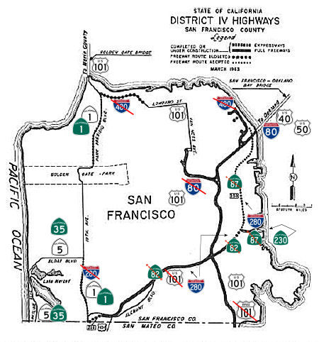
Northern Portion (near San Francisco)
The map below shows some of these changes. The former routing of I-280 ran into San Francisco proper along Route 1, and US 101 ran along what is now the Route 280 routing (as the current US 101 was the Bypass 101 route).
The section between Route 85 and Route 17 was built around 1964; the peninsula section was finished in the early 1970s. Before the section east of Route 17 opened in the early 1970s, I-280 was routed north along Route 17 (present-day I-880) to US 101 in San Jose. The portion between El Camino and US 101 in South San Francisco was formerly an extension of CA 82. The 1989 Loma Priata quake closed the decked portion (north of US 101 in San Francisco) for six years.
In the Los Altos area, according to the Los Altos Town Crier, Los Altos had been hearing plans with regards to a long-range extension of the Junipero Serra Highway/Boulevard as early as 1946; in response, the Business Association declared that any routing through the center of town via Southern Pacific right of way would be rejected. This may be why I-280 tends to be very rural in the area. There may also have been state involvement at least 10 years before Junipero Serra Boulevard became LRN 237. The proposed route was from Loyola Corners (Fremont Avenue at Miramonte) to Arastradero Road. This actually seems to correspond with existing Foothill Expressway.
Interesting factoid: Bids were opened on April 8, 1964 for a bridge to
carry I-280 over the two-mile Stanford Linear Accelerator. Although I-280
wasn't scheduled to be built in that area for a while, the bridge
construction needed to be coordinated with the AEC. Scott Parker (SParker)
elaborated on the subject on AAroads:
(Source: Scott Parker (SParker) on AAroads, "Re: I-280", 3/10/2019)
There is one historic oddity regarding I-280: the bridges over SLAC (Stanford Linear Accelerator Center), on Stanford University land, were constructed between 1965 and 1967, some 4 years before the remaining construction on that segment of freeway commenced -- but in conjunction with the western extension of the accelerator (a long continuous structure that extends under the freeway). This advance construction was done as a joint project between the Division of Highways and Stanford in order to ensure that any vibrations emanating from the bridge structure would not affect SLAC operations and experiments. The bridge bents on either side of the accelerator building are double-isolated, with vibration-absorbing pads between the bridge beams and the vertical bents -- and the bents themselves are sitting in a "sheath" of sand and clays to dissipate any remaining vibrations that might be transmitted to the ground; the entire bridge structure therefore "floats" above the surrounding ground rather than terminating there. It is held in place by its own weight; connected to the remainder of the freeway by a series of short metal bars over which traffic passes (driving it, one feels a series of minor "bumps" at the connecting bars as well as a bit of a "dip" in the middle of the bridge itself -- a deliberately designed "sag" due to the irregular hillside that was carved out to accommodate the accelerator structure. The unusual design of this road-to-structure isolation interface was a condition imposed by Stanford University as part of the agreement to route I-280 through the back of campus property; there are seismometers installed in the ground underneath and adjacent to the bridge to measure the continuous effectiveness of the isolation measures; when particularly precise SLAC experiments are undertaken, I-280 has on rare occasion been closed for the duration of such an experiment. This is a one-of-a-kind accommodation by Caltrans and its predecessor agency made necessary by the nature of this particular atom-smashing device.
In 1965, Chapter 1371 changed the origin: “Route 680 near San
Jose Story Road to Route 480 in San Francisco via Daly
City.”
In 1968, the California Department of Public Works built what is believed
to be the state's first official freeway soundwall on I-680 in Milpitas,
near San Jose.
(Source: LAist, 3/26/2019)
In the San Bruno area, it appears that an early plan was to have I-280 run along Skyline Blvd from near Crystal Springs Road (former Route 117) to near Sneath, and then move NE to the current Serra routing. This shows on some 1967 maps. More information on this can be found on Route 117's entry.
In March 2021, there was an interesting article on what was lost during
construction of the freeways.In Daly City and Colma, I-280 construction
proceeded along the original San Francisco to San Jose rail line, which
had been downgraded to a branch after the bayside cutoff route was
completed in 1906. Parts of the line were repurposed as right-of-way for
BART while I-280 obliterated Railroad Avenue alongside it. Among the
buildings taken was Colma’s community center.
(Source: Climate Online, 3/16/2021)
 Until 1968, this routing ended at Route 480 (present-day
US 101) in San Francisco -- but this was Route 480 right at the connection
with the Golden Gate Bridge -- what today is where Route 1 and US 101
meet. In 1968, Chapter 282 swapped Route 280 off of Route 1 to reflect a
realignment of the freeway plans in San Francisco, moving Route 280 to the
E of I-80, instead of the W. This made the definition: “Route 680
near Story Road to
Until 1968, this routing ended at Route 480 (present-day
US 101) in San Francisco -- but this was Route 480 right at the connection
with the Golden Gate Bridge -- what today is where Route 1 and US 101
meet. In 1968, Chapter 282 swapped Route 280 off of Route 1 to reflect a
realignment of the freeway plans in San Francisco, moving Route 280 to the
E of I-80, instead of the W. This made the definition: “Route 680
near Story Road to Route 480 Route 80 near First
Street in San Francisco via Daly City. Joint Highway District […] Notwithstanding
the provisions of Section 89 of Chapter 1062 of the Statutes of 1959,
construction of all or any portion of Route 280 from Route 101 near
Alemany Boulevard to Route 480 near Harrison Street in San Francisco may
be commenced at any time, if the City and County of San Francisco has
conveyed or does convey to the State of California, without charge, all
real property presently acquired by it for the construction of said
subdivision (b) of this route or such portion thereof.”.
This rewording was the result of a number of route swaps that occured in
1968:
![[1967 Map; excerpt from Chris Sampang's page]](maps/280-army-67.jpg) A portion of Route 82 from Route 1 (present-day
I-280/Route 82 junction) to Route 87 (present-day Route 230) was
transferred to I-280. Route 230 was the route that come off near the
proposed Southern Crossing approach near 3rd and Army. Originally, this
was to have been US 101 (until US 101 was moved to the East onto Bypass
US 101). There are still stub ramps at Army Street indicative of the
Southern Crossing Approach; this is shown in the map to the right which
is excerpted from Chris Sampang's page of 1967 maps (which, sadly, is no
longer on the web).
A portion of Route 82 from Route 1 (present-day
I-280/Route 82 junction) to Route 87 (present-day Route 230) was
transferred to I-280. Route 230 was the route that come off near the
proposed Southern Crossing approach near 3rd and Army. Originally, this
was to have been US 101 (until US 101 was moved to the East onto Bypass
US 101). There are still stub ramps at Army Street indicative of the
Southern Crossing Approach; this is shown in the map to the right which
is excerpted from Chris Sampang's page of 1967 maps (which, sadly, is no
longer on the web). Good information on the history of the design of I-280 may be found in the Sep/Oct 1964 issue of CHPW.
 There is a lot of history on the "freeway revolt" in the Glen Park area, just N of the current I-280 routing near San Jose
Avenue. The original plan was that “The Circumferential Expressway
would be built along the Seventh Avenue - Woodside - O’Shaughnessy
route ... It would connect directly into the Alemeny freeway by way of
Bosworth street ... Eventually it should be extended across Golden Gate
Park to Park-Presidio boulevard for access to the Richmond district and
the Golden Gate Bridge.” According to the Glen Park History page,
Mrs. Hermini "Minnie" Straub Baxter started working against the proposed
freeway in 1958. In January 1959, the San Francisco Board of Supervisors
voted unanimously against the city-wide freeway plan . From an editorial
by the San Francisco Examiner, "The Board of Supervisors correctly
reflected public sentiment when it killed several proposed San Francisco
Freeways last week." Reports surfaced in 1959 and 1960 that the DPW still
planned to widen Bosworth and tunnel under Portola Drive, claiming that
traffic along Bosworth and O’Shaughnessy would double by 1980
because of the new redevelopment project called Diamond Heights. Glen Park
residents labeled the plan as “the Crosstown Freeway plan in
disguise”.By 1965, DPW had purchased and razed nearly 20 structures
along the north side of Bosworth. The widening of Bosworth to four lanes
would not be completed until 1970. DPW then set its sights on
O'Shaughnessy Boulevard by threatening to straighten the hairpin curve
exiting from Glen Park and extending the widened road further up the hill
towards Portola Drive. Concurrently, plans were underway to also widen Elk
Street running along the eastern border of Glen Canyon Park between
Bosworth and Sussex Streets. In the early 1960s, 2 young moms - Zoanne
Theriault and Joan Seiwald - had become new residents of Glen Park. They
had first met on one of their frequent outings to Glen Canyon Park to
entertain their young children. Soon, they would also meet lifelong Glen
Park resident Geri Arkush and quickly became fast friends. Zoanne, Joan,
and Geri called the first meeting of their new Save Glen Park Committee to
order on October 19, 1965. During the meeting, they shared the mission of
the committee: To investigate the plan for the rerouting of
O’Shaughnessy over the recreation area, and to see what could be
done to save Glen Park. The San Francisco Recreation and Park Department
had believed that a freeway hovering over the western baseball diamond and
recreation center would not impair the enjoyment of recreation. The second
Save Glen Park Committee meeting to discuss these issues attracted a
reported 175 concerned residents on November 9, 1965. At the meeting,
George Moscone, in attendance with three other supervisors, assured Glen
Park and Diamond Heights residents that, "The Department of Public Works
isn't so much at fault, but they have been acting on a resolution passed a
long time ago by another Board of Supervisors. Now we have a new board and
I'll give you a guarantee: we come a lot closer to serving your wishes
than any board of highway engineers!" The Transportation Committee of the
Board of Supervisors unanimously agreed: Glen Park should be saved The
last attempt at the freeway plan was in 1970. Finally, again with a
unanimous vote, the Transportation Committee of the Board of Supervisors
rescinded authorization for the widening of O'Shaughnessy.
There is a lot of history on the "freeway revolt" in the Glen Park area, just N of the current I-280 routing near San Jose
Avenue. The original plan was that “The Circumferential Expressway
would be built along the Seventh Avenue - Woodside - O’Shaughnessy
route ... It would connect directly into the Alemeny freeway by way of
Bosworth street ... Eventually it should be extended across Golden Gate
Park to Park-Presidio boulevard for access to the Richmond district and
the Golden Gate Bridge.” According to the Glen Park History page,
Mrs. Hermini "Minnie" Straub Baxter started working against the proposed
freeway in 1958. In January 1959, the San Francisco Board of Supervisors
voted unanimously against the city-wide freeway plan . From an editorial
by the San Francisco Examiner, "The Board of Supervisors correctly
reflected public sentiment when it killed several proposed San Francisco
Freeways last week." Reports surfaced in 1959 and 1960 that the DPW still
planned to widen Bosworth and tunnel under Portola Drive, claiming that
traffic along Bosworth and O’Shaughnessy would double by 1980
because of the new redevelopment project called Diamond Heights. Glen Park
residents labeled the plan as “the Crosstown Freeway plan in
disguise”.By 1965, DPW had purchased and razed nearly 20 structures
along the north side of Bosworth. The widening of Bosworth to four lanes
would not be completed until 1970. DPW then set its sights on
O'Shaughnessy Boulevard by threatening to straighten the hairpin curve
exiting from Glen Park and extending the widened road further up the hill
towards Portola Drive. Concurrently, plans were underway to also widen Elk
Street running along the eastern border of Glen Canyon Park between
Bosworth and Sussex Streets. In the early 1960s, 2 young moms - Zoanne
Theriault and Joan Seiwald - had become new residents of Glen Park. They
had first met on one of their frequent outings to Glen Canyon Park to
entertain their young children. Soon, they would also meet lifelong Glen
Park resident Geri Arkush and quickly became fast friends. Zoanne, Joan,
and Geri called the first meeting of their new Save Glen Park Committee to
order on October 19, 1965. During the meeting, they shared the mission of
the committee: To investigate the plan for the rerouting of
O’Shaughnessy over the recreation area, and to see what could be
done to save Glen Park. The San Francisco Recreation and Park Department
had believed that a freeway hovering over the western baseball diamond and
recreation center would not impair the enjoyment of recreation. The second
Save Glen Park Committee meeting to discuss these issues attracted a
reported 175 concerned residents on November 9, 1965. At the meeting,
George Moscone, in attendance with three other supervisors, assured Glen
Park and Diamond Heights residents that, "The Department of Public Works
isn't so much at fault, but they have been acting on a resolution passed a
long time ago by another Board of Supervisors. Now we have a new board and
I'll give you a guarantee: we come a lot closer to serving your wishes
than any board of highway engineers!" The Transportation Committee of the
Board of Supervisors unanimously agreed: Glen Park should be saved The
last attempt at the freeway plan was in 1970. Finally, again with a
unanimous vote, the Transportation Committee of the Board of Supervisors
rescinded authorization for the widening of O'Shaughnessy.
(Source: Condensed and summarized from "Wonder Women! Glen Park's Gum Tree Girls, Minnie Straub Baxter, and the San Francisco Freeway Revolt", part of the "Glen Park Neighborhoods History Project")
In response to a question as to why I-280 narrowed upon entry to San
Francisco, Mr. Roadshow (Gary Richards) noted "At the current I-280/Route 1 junction, I-280 was originally planned to continue north along the
current Route 1/Junipero Serra alignment. The southern Embarcadero Freeway
was planned to branch off on the right side in the northeast direction
along the current I-280 alignment. Under that original plan, people
wanting to continue heading north on I-280 would have stayed to the left.
Then the San Francisco freeway revolt happened. The plan for the I-280
freeway along the current Route 1/Junipero Serra alignment was eliminated,
although the connection to Junipero Serra was retained. The southern
Embarcadero Freeway was redesignated to be I-280. However, this meant that
the right exit to southern Embarcadero would be forced to become the main
alignment for I-280. Due to the number of lanes in this segment, there was
concern that vehicles wanting to head north on I-280 would be
inadvertently trapped to take the Junipero Serra exit on the left, which
would result in vehicles making last-minute lane changes. The lane
reduction and subsequent lane addition is intended to try to mitigate this
situation. The lane addition occurs on the left side so that at that point
vehicles are in the right five lanes. Vehicles that had been in the No. 1
(fast) lane find themselves in the No. 2 lane after the lane addition.
This means that anyone wanting to continue north on I-280 would need to
move over one lane to the right. If the lanes had been configured normally
without the lane reduction/addition, these vehicles would have had to move
over two lanes instead."
(Source: San Jose Mercury News, 3/8/13)
I-280 currently runs along the route of the original "Southern Freeway".
In 1961, the San Francisco Board of Supervisors endorsed the current I-280
route to meet I-80 at the Bay Bridge. In 1965, this route became part of
the interstate system, and the Park Presidio route was withdrawn. In
October 1969, the city asked the state to stop work on the I-280/I-480
connection. Work on the connection to I-80, however, was allowed to
continue. In 1973, I-280 was completed to 3rd street.
(Thanks to Scott "Kurumi" Oglesby for much of this information)
For information on the potential connection with the Southern Crossing, see I-380.
I-280 Stub (N of 7th Street)
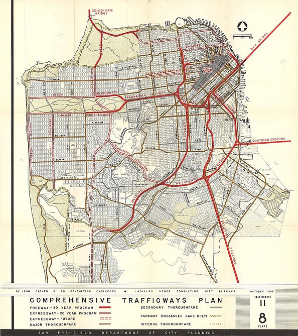
![[480-87 Interchange, 1967 Conception, from Chris Sampang]](maps/1967-480.jpg) I-280 was intended to snake under the Bay Bridge
approach, connect with I-480, and provide access to I-80 and the bridge.
The "Junipero Serra" and "Park Presidio" freeways would roughly parallel
19th Avenue to the east. This was part of a 1951 Trafficways Plan,
supposedly eliminated in a 1959 rework; however, a 1963 plan shows I-280
going north along 19th Street through Golden Gate Park to US 101 and I-80
ending at I-280. The CalTrans 1969 map confirms this proposed route. In
any case, these plans were formally abandoned by CalTrans in 1990.
I-280 was intended to snake under the Bay Bridge
approach, connect with I-480, and provide access to I-80 and the bridge.
The "Junipero Serra" and "Park Presidio" freeways would roughly parallel
19th Avenue to the east. This was part of a 1951 Trafficways Plan,
supposedly eliminated in a 1959 rework; however, a 1963 plan shows I-280
going north along 19th Street through Golden Gate Park to US 101 and I-80
ending at I-280. The CalTrans 1969 map confirms this proposed route. In
any case, these plans were formally abandoned by CalTrans in 1990.
Note that, although the freeway portion of Route 280 does not reach I-80, the route is allocated to a series of surface streets between the freeway terminus at 4th Street/King Street and I-80. According to CalTrans, 53,000 vehicles used the non-freeway portion of I-280 in 2002.
There was once an off-ramp from I-280 to Third Street. The southbound roadway was completely unused past the onramp from 6th.
 In 1962, the CTC adopted the 3.4 mi segment between Evans
Avenue and the Embarcadero Freeway (Route 480). This segment was part of
LRN 253, later Route 87, and later still, I-280. Most of this was
constructed as part of I-280, except for the connection under the Bay
Bridge to the Embarcadero Freeway.
In 1962, the CTC adopted the 3.4 mi segment between Evans
Avenue and the Embarcadero Freeway (Route 480). This segment was part of
LRN 253, later Route 87, and later still, I-280. Most of this was
constructed as part of I-280, except for the connection under the Bay
Bridge to the Embarcadero Freeway.
(Source: Jan/Feb 1962 California Highways and Public Works)
In 2013, Mayor Ed Lee of San Francisco announced his
office would consider ideas for potential redevelopment upon removal of the I-280 stub, plus shrinking or removing the CalTrain yard. Could San Francisco be made anew by the removal of I-280 as
it runs through the city north of 16th Street? That’s what the
Center for Architecture + Design asked in a 2013 contest. For a cash prize
of $10,000, the competition ”encouraged artists, academics,
architects, planners, landscape architects and designers to submit
concepts for public art, buildings, landscape treatments, public amenities
and infrastructure, or other urban design interventions made possible
through the replacement of Highway 280”
(Source: SF Gate, 9/10/13)
 Pre 1964 Signage History
Before the 1964 signed/legislative route alignment, I-280 was made up of the following legislative routes:
As early as 1913, local jurisdictions (San Mateo County) were working on the construction of the original Junipero Serra Highway.
I-280 was approved as part of the Interstate System in 1955. In 1956, the Interstate system established the rough routing of I-280, which likely prompted the creation of LRN 239 in 1957. Portions of the route were adopted in November 1957, July 1958, and July 1960.
 There were routing controversies. In 1957, the routing proposals were presented for
discussion. Route A (favored by the State Engineer) would cost $128
million and would travel a 57.5 mi path that swept close to pennisula
communities along El Camino Real. Route "B" would cost $104 million, and
would run 53.4 mi tracing part of Skyline Blvd in San Mateo County and
swinging closer to Los Gatos on the S. Both routes start at the N end of
Edgemar Road in Daly City, less than a mile from the San Francisco County
line. S of that point, the present Junipero Serra Blvd, including the
parkway section that runs W of San Bruno, would be rebuilt as an
eight-lane divided highway. The alternative routes take shape in the
vicinity of Crystal Springs Road where Route A plunges directly S through
Millbrae, Burlingame, Hillsborough, the western section of San Mateo, and
so on to Los Altos. Route B, taking off from near Crystal Springs Road,
sweeps westward to the present route of Skyline BLvd. It follows Skyline
and La Canada Road to a point N of Woodside. It then dips east and travels
through the relatively undeveloped foothills behind Stanford University
reaching a junction with Route A in Los Altos. A half mile S of Los Altos,
the route diverges again. Route A takes an easterly path, crossing Stevens
Creek Road near Saratoga Ave and connecting with the proposed LRN 5 (Route 17) near Moorpark Avenue in San Jose. Route B, from Los Altos, will swing
W at Campbell, joining LRN 5 at a point about 4 mi E of Los Gatos. From
LRN 5, both routings travel directly S to meet US 101 at Ford Road. If
Route A is selected, there will need to be a leg of the freeway linking
Los Gatos with the main route near Monte Vista. If Route B is selected, it
would be necessary to construct a 3.6 mi freeway through Millbrae linking
Junipero Serra with El Camino Real at Millbrae Ave. It appears the final
routing was a hybrid of various routes. Los Altos and Los Altos Hills
fought on the routing—specifically, over the "B" route along the
railroad in Los Altos or the "C" route through the Los Altos Hills. The
decision was handed down by the CHC on 7/23/1958 in favor of the "C"
routing.
There were routing controversies. In 1957, the routing proposals were presented for
discussion. Route A (favored by the State Engineer) would cost $128
million and would travel a 57.5 mi path that swept close to pennisula
communities along El Camino Real. Route "B" would cost $104 million, and
would run 53.4 mi tracing part of Skyline Blvd in San Mateo County and
swinging closer to Los Gatos on the S. Both routes start at the N end of
Edgemar Road in Daly City, less than a mile from the San Francisco County
line. S of that point, the present Junipero Serra Blvd, including the
parkway section that runs W of San Bruno, would be rebuilt as an
eight-lane divided highway. The alternative routes take shape in the
vicinity of Crystal Springs Road where Route A plunges directly S through
Millbrae, Burlingame, Hillsborough, the western section of San Mateo, and
so on to Los Altos. Route B, taking off from near Crystal Springs Road,
sweeps westward to the present route of Skyline BLvd. It follows Skyline
and La Canada Road to a point N of Woodside. It then dips east and travels
through the relatively undeveloped foothills behind Stanford University
reaching a junction with Route A in Los Altos. A half mile S of Los Altos,
the route diverges again. Route A takes an easterly path, crossing Stevens
Creek Road near Saratoga Ave and connecting with the proposed LRN 5 (Route 17) near Moorpark Avenue in San Jose. Route B, from Los Altos, will swing
W at Campbell, joining LRN 5 at a point about 4 mi E of Los Gatos. From
LRN 5, both routings travel directly S to meet US 101 at Ford Road. If
Route A is selected, there will need to be a leg of the freeway linking
Los Gatos with the main route near Monte Vista. If Route B is selected, it
would be necessary to construct a 3.6 mi freeway through Millbrae linking
Junipero Serra with El Camino Real at Millbrae Ave. It appears the final
routing was a hybrid of various routes. Los Altos and Los Altos Hills
fought on the routing—specifically, over the "B" route along the
railroad in Los Altos or the "C" route through the Los Altos Hills. The
decision was handed down by the CHC on 7/23/1958 in favor of the "C"
routing.
(Source: SF Examiner, 4/5/1957 and Palo Alto Times, 11/11/1964 via
Joel Windmiller, 2/13/2023)
In 1958, it was reported in CHPW that planning studies on the Southern Freeway have been completed and a route adopted for an eight-lane freeway following generally along the old Southern Pacific Railroad locations and Alemany Boulevard between Orizaba Avenue, near. the south city limits of San Francisco, and the James Lick Memorial Freeway (Bayshore). Route location west of Orizaba Avenue is dependent on future location of the Junipero Serra Freeway. Further S, in 1957 LRN 239 was created by the legislature in 1957, and the short segment along Moorpark Ave in San Jose from Saratoga Ave to signed Route 17 was adopted as freeway.
 Status
 According to the 2013 Traversable Highways report, unconstructed from 6th Street to I-80. Route 280 has been extended to 4th
Street/King Street. SF County has no plans to implement. Proposal to
create a boulevard from Mariposa to 6th Street may have future impact.
According to the 2013 Traversable Highways report, unconstructed from 6th Street to I-80. Route 280 has been extended to 4th
Street/King Street. SF County has no plans to implement. Proposal to
create a boulevard from Mariposa to 6th Street may have future impact.
San Jose (US 101) to Cupertino (Route 85) (SCL 0.0 to SCL 10.689)
PPNO 0503J I-280 Soundwalls, Route 87-Los Gatos Creek Bridge (~ SCL 5.33 to SCL R010.80)
The 2018 STIP, approved at the CTC March 2018 meeting, appears to allocate $7M for PPNO 0503J I-280 Soundwalls, Route 87-Los Gatos Creek Bridge (~ SCL 5.33 to SCL R010.80).
The 2020 STIP, approaved at the CTC March 2020 meeting,
continued the programming for PPNO 0503J Rt 280 Soundwalls, Rt 87-Los
Gatos Creek Bridge, $833K in prior years, and $929K in FY20-21, $456K in
FY 21-22, and $4,782K in FY22-23.
(Source: March 2020 CTC Agenda, Item 4.7, 2020 STIP
Adopted 3/25/2020)
In June 2021, the CTC approved a request from the Santa
Clara Valley Transportation Authority to delete $3,207K in STIP
construction funds from the Silicon Valley Express Lanes Program - Phase 5
Civil project (US 101 SCL 38.300/45.900 PPNO 2015H EA 04-1K553) and
reprogram those funds to cover Right of Way and Construction funding
shortfall for the I-280 Soundwalls – Route 87 to Los Gatos Creek
project (I-280 SCL 2.500/3.200 PPNO 0503J EA 04-44840K) in Santa Clara
County.
(Source: June 2021 CTC Agenda, Agenda Item
2.1a.(3))
In June 2023, the CTC approved a STIP amendment
(noticed at the May 2023 meeting) that, for the I-280 Soundwalls –
Route 87 to Los Gatos Creek project (PPNO 0503J), deletes the CON phase
funding programmed with RIP funds of $6,064,000 in 2023-24 and instead
programs the CON phase in 2023-24 with COVID-RIP funds. The I-280
Soundwalls - Route 87 to Los Gatos Creek project (PPNO 0503J) will reduce
existing noise levels along I-280 in downtown San Jose. The project
location was initially identified by the Department as a candidate for
noise reduction in the early 1990’s and it is still in need of
mitigation. The project scope includes building soundwalls on I-280
between Route 87 and Los Gatos Creek. This project is on schedule for a
CON allocation in 2023-24. It needs additional funds as the
construction cost estimate has increased. This is due to increased traffic
control, new work zone protection requirements, additional work to avoid
existing utilities, overall escalation of bid items owing to current
economic conditions, and anticipated inefficiency markup due to
accessibility to the work sites.
(Source: June 2023 CTC Agenda, Agenda Item 2.1a.(14))
I-280/I-880 Interchange (~ SCL L5.346)
According to the Mercury News, there are plans for a major overhaul of the I-280/I-880 interchange, that will cost at least $109,000,000 and won't commence until at least 2011. The original plan was to simply redesign the ramp from north I-280 to north I-880 and Stevens Creek Boulevard, including redesigning the exits from Route 17 and I-280 onto Stevens Creek and north I-880, where drivers must now merge into a single lane, creating backups on I-280 and I-880 that extend for miles. However, it turned out that the primary problem is the intersection at Monroe Street and Stevens Creek, the first entrance into Westfield Valley Fair, where one in three cars coming off I-880 is headed. Cars exiting from south I-880 must jam onto Stevens Creek before they reach Monroe; planners realized that until this problem is addressed, other fixes will do little good. So a more comprehensive plan was developed that includes:
Note that about 85% of traffic from north I-280 is headed to Stevens Creek, while 15% is going to I-880 on weekends and during the afternoon commute. During the early hours of the weekday morning commute, three out of five vehicles are going toward Stevens Creek compared to I-880, changing to an 80/20 split by 10:00 am.
A later report on the construction in January 2009 noted that construction could be under way in 2010, and, at about $150 million, the price tag will top the $135 million spent to rebuild the Route 85/US 101 interchange in Mountain View, the previous Northern California record for such work. Gone will be the many cloverleaf ramps and dangerous merges, replaced by longer exit lanes, much wider ramps and a wider Stevens Creek Boulevard. The issue is the source of funding. About $21 million is in hand as of January 2009, enough to complete the first phase from south I-880 onto Stevens Creek. State and federal highway funds, future bond money and some federal stimulus dollars also could also be earmarked for this project.
In June 2009, the CTC received notice of the preparation of the EIR for the I-280/I-880/Route 17 interchange project. The project will modify the Route 17 / I-280 / I-880 freeway, as well as two adjacent interchanges at Interstate 880/Stevens Creek Boulevard and I-280 / Winchester Boulevard. The project is not fully funded. Likely funding sources include federal earmark, as well as local funding from the City of San Jose and the Santa Clara Valley Transportation Agency. The total cost of the project is estimated between $130,000,000 and $150,000,000. Assuming the availability of funding, construction is estimated to begin in Fiscal Year 2010-11.
In April 2011, Gary Richards noted plans are being scaled back. Work should be under way late in 2012 to build a flyover ramp from north I-280 to north I-880 -- a good thing as it will separate that traffic from drivers trying to go from I-280 to Stevens Creek and the shopping areas west of the interchange. The exit from south I-880 to Stevens Creek will also be widened to two lanes, along with improvements to the Stevens Creek overpass. But plans to add a new exit from north I-280 to Winchester Boulevard to serve as a back entrance to Santana Row have been scrapped.
In October 2011, the CTC approved for future consideration of funding a project to construct improvements at the Route 17/I-280/I-880 Interchange and I-880/Stevens Creek Boulevard Interchange. The project will be done in phases. Phase 1 will construct northbound I-280 to NB I-880 direct connector, reconfigure northbound I-880/Stevens Creek Boulevard Interchange quadrant, widen I-880/Stevens Creek Boulevard Overcrossing and construct soundwall along Parkmoor Avenue. Phase 2 will reconfigure southbound I-880/Stevens Creek Boulevard Interchange quadrant, construct Monroe Street dedicated lane and construct soundwall along S. Daniel Way. Phase 1 can proceed without Phase 2. Phase 1 is programmed in the Corridor Mobility Improvement Account and includes local funds. The total estimated cost of Phase 1 is $54,400,000, capital and support. Phase 2 is not currently programmed. The total estimated cost of Phase 2 is $10,200,000, capital and support. Construction is estimated to begin in Fiscal Year 2012-13. The scope as described for the preferred alternative is consistent with the project scope set forth in the proposed project baseline agreement. A copy of the FEIR has been provided to Commission staff. Resources that may be impacted by the project include; noise, hazardous waste, biological resources, visual and aesthetics, water quality and stormwater runoff, and traffic. Potential impacts associated with the project can all be mitigated to below significance through proposed mitigation measures. As a result, a Final Environmental Impact Report was prepared for the project.
In November 2012, groundbreaking occured for the updates to the I-280/I-880 interchange. There will be a new flyover ramp from N I-280 to N I-880. SB I-880 will get a second lane to exit onto Stevens Creek, and then the offramp will widen to four lanes at this busy street. It will also be possible to exit from SB I-880 directly onto Monroe Street and into the Valley Fair parking lot. Bicycle lanes and sidewalks will be added on Stevens Creek.
In June 2012, Gary Richards explained the reason that there are only three lanes on I-280 at the I-880/Route 17 underpass. This lane drop is there because of the limited width available with existing column locations under the bridge; opening a fourth lane at this pinch point would involve extensive and costly improvements between the Winchester Boulevard overpass and the I-880 overcrossing. Additionally, it allows drivers coming north on Route 17 to have their own lane for a short distance and not be forced to immediately merge with I-280 traffic. This is also related to the cloverleaf interchange ramp connecting NB Route 17 to NB I-280 in San Jose. It originally had two lanes, but was re-striped for only one lane. This was done to enable drivers heading on I-280 to Stevens Creek to enter into their own lane and avoid merging with traffic trying to get to NB I-880.
In July 2014, an update was provided on the I-280/I-880
interchange construction. The framework for the $62.1 million interchange
adjacent to the busy shopping centers at Valley Fair and Santana Row is in
place. Before Christmas 2014, many new lanes will be installed. Workers
are demolishing the pedestrian walkway and replacing it temporarily with
an asphalt pathway. A permanent sidewalk should be in place after Labor
Day 2014. This will permit crews to build an offramp from southbound I-880
to Stevens Creek Boulevard. By Thanksgiving, this new offramp will be open
featuring four lanes to Stevens Creek, three of which will be righthand
turn lanes toward the two shopping centers. Another lane feeding freeway
traffic directly onto Monroe Street and into the Valley Fair parking lot
will open in Spring 2015. Additionally, before Christmas and before the
large shopping crowds bring the area to its usual gridlock, the north
Route 17/I-280 ramps to San Carlos Street should complete construction.
Lanes on north I-280 will also be realigned so cars in the far right lane
will exit toward Oakland instead of Los Gatos — a much more logical
layout than what's there now. This reconstruction is a scaled-back version
of what had been planned. There will be no exit from north I-280 onto
Winchester Boulevard to allow for a back way into Santana Row, as VTA
wanted, nor will there be a second lane for traffic going south on I-880
to reach north I-280. Caltrans feared that this ramp would be too close to
the new interchange and create more problems than it would ease.
(Source: San Jose Mercury News, 7/8/14)
In September 2014, it was reported that construction
was nearly complete on the I-280/I-880 interchange project. In September,
three new on- and offramps to Stevens Creek Boulevard opened, and by
Thanksgiving 2014 a special lane feeding traffic onto Monroe Street and
bypassing Stevens Creek Boulevard was anticipated to be ready. Motorists
driving south on I-880 will use a new signalized offramp to turn onto
Stevens Creek. There will be three lanes turning right toward Valley Fair
and Santana Row and one lane turning left toward downtown San Jose.
Drivers on Stevens Creek headed to southbound Route 17 and southbound
I-280 will use a new onramp located closer to the freeway than the current
one. Motorists traveling to Stevens Creek from northbound Route 17 and
northbound I-280 will see a new signalized intersection. Traffic from
these ramps will no longer cross underneath the Stevens Creek Bridge and
loop onto the busy street. Instead, they will make a left-hand turn
through a new intersection with traffic lights. Of the $62.1 million cost,
$39.2 million came from state bonds approved by voters in 2006. The
federal government chipped in $19 million, and the remainder came from
local tax dollars. The reconstruction is a scaled-back version of what had
been planned. There will be no exit from north I-280 onto Winchester
Boulevard to allow for a back way into Santana Row, as VTA wanted, nor
will there be a second lane for traffic going south on I-880 to reach
north I-280. All that would have run the cost up to $150 million, and
Caltrans feared that this ramp would be too close to the new interchange
and create more problems than it would ease.
(Source: SJ Mercury News, 9/28/2014)
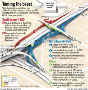 In June 2015, it was again reported that work was nearly complete on the
I-280/I-880 interchange project. Motorists were already driving easier,
thanks to the $63 million worth of new ramps and the wider overpass to
serve the growing shopping meccas at Valley Fair and Santana Row. Some
ramps need finishing, and signs updated. The most significant upgrade is
the exit from south I-880 directly onto Monroe Street. When plans were
first hatched to begin revamping the Valley Fair interchange, Caltrans,
the Valley Transportation Authority and city engineers thought the
solution was obvious and not overly challenging: Redesign the exits from
Route 17 and I-280 onto Stevens Creek.
In June 2015, it was again reported that work was nearly complete on the
I-280/I-880 interchange project. Motorists were already driving easier,
thanks to the $63 million worth of new ramps and the wider overpass to
serve the growing shopping meccas at Valley Fair and Santana Row. Some
ramps need finishing, and signs updated. The most significant upgrade is
the exit from south I-880 directly onto Monroe Street. When plans were
first hatched to begin revamping the Valley Fair interchange, Caltrans,
the Valley Transportation Authority and city engineers thought the
solution was obvious and not overly challenging: Redesign the exits from
Route 17 and I-280 onto Stevens Creek.
(Source (including image): SJ Mercury News, 6/16/2015)
The San Jose Mercury News has received reports of
problems with the new I-280/I-880 interchange. There are reports of poorly
marked embankments, missing reflectors, and badly marked transitions.
There have been numerous accidents or near accidents. Caltrans is looking
at what can be done to make the interchange safer, as too many drivers
have reported near-rollovers.
(Source: SJ Mercury News, 3/21/2016; 4/5/2016)
In September 2016, it was reported that more work was coming to the
Stevens Creek interchange (~SCL 7.43) in October, when the Apple
spaceship-related project swings into a new phase when work on a new lane
on the I-280 north off-ramp at Lawrence is set to begin. This should last
nine months. Caltrans will add a right-turn lane onto Stevens Creek and
the city of Santa Clara will adjust the Stevens Creek signal after work
wraps up; Apple will chip in toward the project costs. They’ll add a
second left-turn-only lane from the north I-280 exit ramp onto Stevens
Creek for a total of four lanes approaching Stevens Creek. Additionally,
the I-280 southbound off-ramp at Wolfe Road will be widened to two lanes
back to the freeway; the I-280 north off-ramp at Wolfe will be widened to
two lanes and an additional lane will be added at Wolfe, resulting in a
double left and double right turn; and a third northbound lane will be
constructed on Wolfe north of the loop on-ramp to Pruneridge .Calvert is
down to one lane, but a second lane is coming as well as new signals at
Stevens Creek/Calvert and Calvert/Lawrence.
(Source: East Bay Times, 9/6/2016)
I-280/Wolfe Road Interchange Improvements Project (~ SCL 15.32)
 In December 2020, a post on AARoads highlighted the I-280/Wolfe Road
Interchange Improvements Project. The Santa Clara Valley Transportation
Authority (VTA), in cooperation with the City of Cupertino and the
California Department of Transportation (Caltrans), proposes to modify the
Wolfe Road interchange on I-280 in the City of Cupertino in order to
improve traffic operations, and facilities for several modes of
transportation including bicycle, pedestrian and high occupancy vehicle
uses at the interchange. The proposed improvements include, but are not
limited to, the following: (1) Construct new structure carrying Wolfe Road
over I-280; (2) Construct new on-ramps and off-ramps; (3) Modify existing
local street intersections and upgrade bicycle and pedestrian facilities
along Wolfe Road; (4) Construct retaining walls and sound walls as needed.
VTA and the City of Cupertino hosted a virtual Open House on December 9,
2020, providing project updates and presented the preferred design for the
I-280 and Wolfe Road Interchange Project, funded by 2016 Measure B sales
tax. Construction is planned for the 2022-2025 time frame. VTA maintains a
project information page at https://www.vta.org/projects/i-280wolfe-road-interchange-improvements-project. Kurimi noted that this is a parclo B4
interchange, built in the 1960s, where the overpass carries four lanes for
Wolfe Road. The Apple headquarters is nearby and will resume being a large
traffic generator once people return to their offices in 2021. A couple
years ago, the exit ramps were widened: formerly a single lane exit,
widening into left | either | right turning lanes; now a two-lane (exit
only + option lane, a favorite CA design) widening into left | left |
right | right. But the overpass, with only 2 lanes in each direction, is a
bottleneck. There had been talk of widening the overpass, but replacing
the parclo with a SPUI or even a diamond. But the project details paint a
better picture. Wolfe Road is 3 lanes each direction throughout; with
right-turn (exit) lanes, the overpass is now 8 lanes. All 6 ramps of the
parclo are retained, though the geometry is changed a bit. Exit ramps are
widened to 5 turning lanes (left | left | either | right | right). Bike
lanes are added; these and sidewalks cross ramp traffic at right angles.
In December 2020, a post on AARoads highlighted the I-280/Wolfe Road
Interchange Improvements Project. The Santa Clara Valley Transportation
Authority (VTA), in cooperation with the City of Cupertino and the
California Department of Transportation (Caltrans), proposes to modify the
Wolfe Road interchange on I-280 in the City of Cupertino in order to
improve traffic operations, and facilities for several modes of
transportation including bicycle, pedestrian and high occupancy vehicle
uses at the interchange. The proposed improvements include, but are not
limited to, the following: (1) Construct new structure carrying Wolfe Road
over I-280; (2) Construct new on-ramps and off-ramps; (3) Modify existing
local street intersections and upgrade bicycle and pedestrian facilities
along Wolfe Road; (4) Construct retaining walls and sound walls as needed.
VTA and the City of Cupertino hosted a virtual Open House on December 9,
2020, providing project updates and presented the preferred design for the
I-280 and Wolfe Road Interchange Project, funded by 2016 Measure B sales
tax. Construction is planned for the 2022-2025 time frame. VTA maintains a
project information page at https://www.vta.org/projects/i-280wolfe-road-interchange-improvements-project. Kurimi noted that this is a parclo B4
interchange, built in the 1960s, where the overpass carries four lanes for
Wolfe Road. The Apple headquarters is nearby and will resume being a large
traffic generator once people return to their offices in 2021. A couple
years ago, the exit ramps were widened: formerly a single lane exit,
widening into left | either | right turning lanes; now a two-lane (exit
only + option lane, a favorite CA design) widening into left | left |
right | right. But the overpass, with only 2 lanes in each direction, is a
bottleneck. There had been talk of widening the overpass, but replacing
the parclo with a SPUI or even a diamond. But the project details paint a
better picture. Wolfe Road is 3 lanes each direction throughout; with
right-turn (exit) lanes, the overpass is now 8 lanes. All 6 ramps of the
parclo are retained, though the geometry is changed a bit. Exit ramps are
widened to 5 turning lanes (left | left | either | right | right). Bike
lanes are added; these and sidewalks cross ramp traffic at right angles.
(Source: Kurumi on AARoads, "I–280 exit 10 Wolfe Road improvements (Cupertino, CA)", 12/14/2020; VTA Project Information Page; Image source: VTA Project Information Page)
Scott Parker noted that the
original interchange was constructed to funnel traffic to and from the
now-defunct Vallco shopping mall at Wolfe and Stevens Creek; with Apple's
new HQ and a major Kaiser hospital (both a destination and traffic source)
just to the northeast (their property corners abut) the emphasis has
shifted from south and west of I-280 to north and east. With only
isolated retail/dining establishments nearby (and most of those currently
shifted into neutral or worse) there's little pedestrian traffic save
Apple folks out for lunch-break exercise. To that end, rumor
(reinforced by local journalism) has it that Apple was instrumental in
getting bike-and-pedestrian amenities improved in the area as "perks" for
their workforce.
(Source: Scott Parker on AARoads, "I–280 exit 10 Wolfe Road improvements (Cupertino, CA)", 12/15/2020)
Cupertino (Route 85) to San Mateo (Route 92) (~ SCL 11.039 to SM 10.543)
In November 2017, it was reported that the Valley Transportation
Authority will release a study in early 2018 of what drivers say is needed
on I-280 from San Jose to San Mateo County — and adding a fourth
southbound lane near Magdalena surely going to be at the top of the wish
list. The lane would need to be extended for several miles to south of
Magdalena Avenue (~ SCL 14.173) and at least a half-mile beyond the
beginning of the carpool lane. The shoulder area cannot be used for
traffic lanes particularly for this length because of state and federal
standards.
(Source: Mercury News, "Mr Roadshow" 11/6/2017)
On NB I-280 in San Mateo County, just after the Edgewood Road exit (~ SM 6.645) and another exit for a vista point, a few miles before the Route 92 exit, there is a ramp that always has a barrier with the words "road closed" on it. This appears to be a closed vista point; the reason for the closure was reportedly drug dealing as well as, ahem, usual vista point activities.
In September 2018, the governor signed
legislation authorizing the Santa Clara Transportation Valley
Transportation Authority (VTA) to apply to the commission pursuant to the
provisions to conduct, administer, and operate HOT lanes or other toll
facilities on US 101 and a specified portion of Route 280 in the City and
County of San Francisco if the San Francisco County Transportation
Authority (SFCTA) approves the facilities before VTA submits an
application to the commission for approval. The bill would require VTA to
conduct, administer, and operate the facility in coordination with SFCTA.
The bill would require SFCTA, in collaboration with the department and
VTA, to develop the expenditure plan and would require the governing board
of SFCTA to review and approve the expenditure plan and any updates.
(Source: AB 2865, Chapter 501, 9/18/2018)
San Mateo (Route 92) to Daly City (Route 1)
In March 2016, it was reported that San Mateo County was considering new
billboards along I-280 and US 101. Later reports clarified that the county
was never seriously thinking of billboards on I-280 because they are not
allowed, and that any new billboards would have to be on county land.
(Source: San Mateo Daily Journal, 3/28/2016)
Daly City (Route 1) to San Francisco (I-80)
In January 2023, the CTC approved SB1 pre-construction project phase
allocation of $7,004,000. 04-SF-280 R0/T7.5. PPNO 04-2022B; ProjID
0418000045; EA 0Q120. I-280 In the City and County of San Francisco, from
San Mateo County line to Brannan Street. Rehabilitate pavement, upgrade
concrete median barrier, rehabilitate drainage systems, upgrade facilities
to Americans with Disabilities Act (ADA) standards, and replace Whipple
Avenue Pedestrian Overcrossing № 34-0096. (G13 Contingency)
(Categorically Exempt) Seven month allocation time extension for PS&E
and R/W Sup approved under Waiver 22-73; June 2022. PS&E $6,682,000;
R/W Sup $322,000.
(Source: January 2023 CTC Agenda, Agenda Item 2.5b.(2b) #1)
San Francisco (East of I-80)
This routing is unconstructed from 2 miles south of I-80 to I-80. Currently, I-280 is undergoing a seismic retrofit. This will add an on-ramp at 4th and Townsend. Caltrans is also building new ramps from I-280 near 6th street to the newly widened King Street. They are also dismantling all the old I-280 roadway from 3rd Street to these new ramps, shortening I-280 by 3 blocks. The Caltrans mid-1980s "Route Concept Reports" projected a 2005 need for 14-16 lanes for I-280 between Route 85 and I-880; and for 14 lanes for I-880 from US 101 to Route 237.
Proposal to Demolish Northern End of I-280
In May 2011, it was reported that the northernmost stretch of I-280 could be demolished and turned into an Octavia Boulevard-like parkway under options being considered by the California High-Speed Rail Authority. The freeway currently ends around Fourth and King streets, near AT&T Park. According to the San Francisco Examiner, it could be removed north of 22nd Street to accommodate high-speed rail, which is expected to travel through the Peninsula along Caltrain’s route. City officials proposed removing the freeway to avoid tunneling several roads beneath the tracks of the proposed rail system. Caltrain now runs beneath I-280 for about five blocks north of 18th Street. The rail authority wants to follow that path, burying a second set of tracks beneath Caltrain’s route. That would yield a total of four tracks, two buried and two at street level. If there is not enough room to fit four parallel tracks between the underground pilings that support I-280, a length of I-280 would be removed and reconstructed as a parkway from 18th Street north.
In January 2013, the mayor of San Francisco, Ed Lee, floated the idea of tearing down the stub end of I-280 in San Francisco in hopes of creating a new neighborhood and speeding up the arrival of high-speed rail service downtown. The notion is to knock down I-280 before 16th Street - eliminating the ramps both at Sixth and Brannan streets and at Fourth and King streets. It would be replaced by a street-level boulevard akin to those built after the Embarcadero and Central freeways were knocked down. The plan also calls for clearing out the adjacent rail yard to make way for a high-speed rail line.
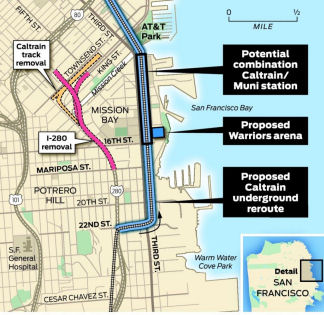 The idea was floated again in May 2015. His current goal is to to tear down
Interstate 280 at Mission Bay and build an underground rail tunnel through
the area — complete with a station between the proposed Warriors
arena and AT&T Park. This is part of an effort to bring Caltrain
— and, one day, high-speed rail — into downtown and the new
Transbay Terminal while opening up a whole new area of the city for
development. As an added bonus, moving Caltrain’s current station a
couple of blocks to the southeast — from Fourth and King streets to
a site roughly opposite Pier 50 on Third Street — would help Lee
sell the argument that he can keep a Warriors arena from creating huge
traffic problems. Lee first proposed the idea in 2013 of of knocking down
I-280 north of Mariposa Street and replacing it with a street-level
boulevard like those built after the Embarcadero and Central freeways were
torn down. Since then, the city has been awarded $1.7 million in grants
from the Metropolitan Transportation Commission and others to study the
idea. Caltrain’s first reaction to the idea was tepid at best. No
comment from Caltrans.
The idea was floated again in May 2015. His current goal is to to tear down
Interstate 280 at Mission Bay and build an underground rail tunnel through
the area — complete with a station between the proposed Warriors
arena and AT&T Park. This is part of an effort to bring Caltrain
— and, one day, high-speed rail — into downtown and the new
Transbay Terminal while opening up a whole new area of the city for
development. As an added bonus, moving Caltrain’s current station a
couple of blocks to the southeast — from Fourth and King streets to
a site roughly opposite Pier 50 on Third Street — would help Lee
sell the argument that he can keep a Warriors arena from creating huge
traffic problems. Lee first proposed the idea in 2013 of of knocking down
I-280 north of Mariposa Street and replacing it with a street-level
boulevard like those built after the Embarcadero and Central freeways were
torn down. Since then, the city has been awarded $1.7 million in grants
from the Metropolitan Transportation Commission and others to study the
idea. Caltrain’s first reaction to the idea was tepid at best. No
comment from Caltrans.
(Source: SFGate, 5/11/2015)
In February 2016, it was reported that the city of San
Francisco had started briefing the initial findings from the first phase
of a long-range study dubbed the Rail Yard Alternatives and I-280
Boulevard Feasibility Study (RAB). This study investigating how San
Francisco can most efficiently and cost-effectively connect all of these
public transit investments locally and regionally. A minor portion of the
study focused on the idea of razing a 1.2-mile portion of I-280 and
turning the connection into a boulevard South of Market. Four other
categories have been studied in more depth and will be examined further
over the next year. Those areas are realigning the downtown rail extension
to bring high-speed rail system to the future Transbay Transit Center,
creating a loop that ensures both Caltrain and high-speed rail do not
dead-end at the future transit hub, reconfiguring or relocating the Fourth
& King railyard and the resulting public benefits if parcels of public
land were freed of transportation infrastructure. With respect to I-280,
the city planned to continue to work with Caltrans, SFMTA and the San
Francisco County Transportation Agency to study the feasibility of razing
the last 1.2 miles of the freeway, potentially ending it as far back as
Mariposa Street in Mission Bay. This could be done all at once or in
pieces and there will be a large public discussion focused on this aspect
down the road.
(Source: Hoodline, 2/25/2016)
In March 2016, the San Francisco Examiner unearthed two
sets of blueprints related to I-280 and the rail tunnel. One set of
blueprints, drawn in 1969, planners say shows evidence that to build a new
Caltrain extension, I-280 must come down — no questions asked. The
other set of plans, two decades old, purportedly shows a road not taken
— how the Caltrain extension could be built without the need to tear
down I-280. In the 1969 blueprints, there is one glaring issue: I-280 is
too narrow to bore a tunnel underneath. The blueprints show I-280’s
pylons are 24 feet apart. That’s smaller than any train tunnels that
could be dug up beneath the freeway. Even though the pylons are 24-feet on
centerline, “inside spacing — or the width between the edge of
a piling to another piling — is less than that.” “Big
Alma,” the main boring machine used in 2014 to dig the hole for the
Central Subway in Chinatown, has a diameter of 22-feet. However, a single
tunnel bore is at least 28 feet in diameter — too wide to fit. With
respect to tunneling two bores around the pilings, you wouldn’t be
able to ‘bring them together’ in the space that you have
before entering the downtown extension. On the other hand, a set of
drawings labeled with the Muni “worm” logo, titled
“Phase 1 Design Conceptual Engineering Drawing,” last redrawn
Nov. 5, 1993, show Caltrain tracks to the Downtown Extension depressed
only five feet below the surface, instead of tunneling underground . To
join Mission Bay with the rest of The City, the blueprints feature a
construction nowhere else in San Francisco — an underground roadway,
and accompanying pedestrian passage.
(Source: SF Examiner, 3/27/2016)
In December 2022, it was reported that State Sen. Scott
Wiener (D-San Francisco) formally asked the California Department of
Transportation to study the cost and logistics for taking down the Central
Freeway, the Bayshore Viaduct of I-80 between 17th Street and the Bay
Bridge, and I-280 north of US 101. The letter, cosigned by a dozen
advocacy groups, adds momentum to a small but growing campaign to remove
some of the city’s freeways. Caltrans is working on a response to
Wiener. The belief of the proponents is that removal would help Caltrans'
budget, potentially make way for housing and open space, and better
connect Mission Bay with the city center.
(Source: San Francisco Standard, 12/1/2022)
In December 2017, it was reported that San Francisco was exploring
creating HOV/HOT (Express) lanes on SB I-280 from 5th St to US 101, and on
NB I-280 from 18th St to 5th St.
(Source: SF Examiner, 12/27/2017)
 Commuter Lanes
In the city and county of San Francisco, there were HOV lanes from S of the Sixth Street on-ramp to S of Army Street, for 1.6 miles. These were opened in 1975, but closed by the Loma Prieta earthquake.
In Santa Clara County, there is a southbound HOV lane from the Magdalena Avenue on-ramp to N of Meridian Avenue, for a length of 11.2 mi. There is a northbound HOV lane from S of Leland Avenue to the Magdalena off-ramp, for a length of 10.7 mi. These were opened in December 1990, require two or more occupants, and are in operation weekdays between 5:00am and 9:00am and between 3:00pm and 7:00pm.
A 2001 Caltrans survey showed that use of the HOV lane dropped near the Highway 17 interchange, from 4,256 vehicles in 1996 to 2,561 in 2001. This freeway continues to rank as the least-used HOV lane in the San Jose Valley.
 Naming
The portion of this route from the I-280/US 101 junction to Route 17 (~ SCL R0.162 to SCL L5.278) is named the "Sinclair Freeway". Joseph P. Sinclair was District Engineer for the District 4 Division of Highways (now Caltrans) from 1952 to 1964. Named by Assembly Concurrent Resolution 104, Chapt. 168 in 1967. His son, Mike Sinclair, provided more information regarding his father: This stretch of I-280 and I-680 provided San Jose with its first freeway service. The concept for the freeway took shape during the tenure of Joseph Sinclair as District Engineer in charge of District IV, California State Division of Highways (now Caltrans), from 1959 to 1964. Route location studies were initiated in 1955, and adopted as part of the Interstate System in 1962. Much planning and research went into the design of this freeway in order to provide both a beautiful and functional facility. The City of San Jose and the Division of Highways negotiated a cooperative agreement for the development of park and recreational facilities within the freeway right-of-way at six locations along this route in a precedent-setting Freeway/Parks concept. To make the freeway more compatible with the adjacent residential properties, the first noise barrier in the Bay Area was installed. The freeway passed through an old Olive orchard. Many of the trees were removed and replanted within the freeway right of way to preserve these old trees. The freeway was landscaped and was officially designated as a "landscape freeway". When a freeway gets this official designation it eliminates the possibility of outdoor advertising being placed adjacent to the freeway. Sinclair was a pioneer in the design and routing of the state's freeway system. Born in Minnesota in 1910, he joined the Division of Highways in 1932 as rodman on a survey party, after graduation from the University of Southern California as a civil engineer. Subsequently, he filled positions of increasing responsibility as a freeway planner, designer, and builder in San Diego and Los Angeles, prior to coming to San Francisco in 1952. During World War II he served as Lieutenant Commander in the US Navy Seabees, stationed in the South Pacific. At the time of his death in 1964 he had become nationally known in his profession. In designating a freeway in his honor, the legislature for the first time named a highway after a civil engineer.
 The portion of this route from the Junction of Route 17/Route 880 in San Jose to the Junction with Route 1 in Daly City
(~ SCL L5.278 to SM R25.233) is named the "Junipero Serra Freeway".
Junipero Serra (November 24, 1713 – August 28, 1784) was a Roman
Catholic Spanish priest and friar of the Franciscan Order who founded a
mission in Baja California and the first nine of 21 Spanish missions in
California from San Diego to San Francisco, in what was then Alta
California in the Province of Las Californias, New Spain. Serra was
beatified by Pope John Paul II on September 25, 1988, in the Vatican City.
Pope Francis canonized him on September 23, 2015, at the Basilica of the
National Shrine of the Immaculate Conception in Washington, D.C., during
his first visit to the United States. His missionary efforts earned him
the title of Apostle of California. Named by Assembly Concurrent
Resolution 140, Chapter 208 in 1967. Note that there is controversy
regarding the honoring of Serra in light of modern sensibilities. Per
Wikipedia, "The New York Times noted that some "Indian historians and
authors blame Father Serra for the suppression of their culture and the
premature deaths at the missions of thousands of their ancestors." George
Tinker, an Osage/Cherokee and professor at Iliff School of Theology in
Denver, Colorado, cites evidence that Serra required the converted Indians
to labor to support the missions. Tinker writes that while Serra's
intentions in evangelizing were honest and genuine, overwhelming evidence
suggests that the "native peoples resisted the Spanish intrusion from the
beginning"."
The portion of this route from the Junction of Route 17/Route 880 in San Jose to the Junction with Route 1 in Daly City
(~ SCL L5.278 to SM R25.233) is named the "Junipero Serra Freeway".
Junipero Serra (November 24, 1713 – August 28, 1784) was a Roman
Catholic Spanish priest and friar of the Franciscan Order who founded a
mission in Baja California and the first nine of 21 Spanish missions in
California from San Diego to San Francisco, in what was then Alta
California in the Province of Las Californias, New Spain. Serra was
beatified by Pope John Paul II on September 25, 1988, in the Vatican City.
Pope Francis canonized him on September 23, 2015, at the Basilica of the
National Shrine of the Immaculate Conception in Washington, D.C., during
his first visit to the United States. His missionary efforts earned him
the title of Apostle of California. Named by Assembly Concurrent
Resolution 140, Chapter 208 in 1967. Note that there is controversy
regarding the honoring of Serra in light of modern sensibilities. Per
Wikipedia, "The New York Times noted that some "Indian historians and
authors blame Father Serra for the suppression of their culture and the
premature deaths at the missions of thousands of their ancestors." George
Tinker, an Osage/Cherokee and professor at Iliff School of Theology in
Denver, Colorado, cites evidence that Serra required the converted Indians
to labor to support the missions. Tinker writes that while Serra's
intentions in evangelizing were honest and genuine, overwhelming evidence
suggests that the "native peoples resisted the Spanish intrusion from the
beginning"."
(Image source: A Kaua'i Blog; Weird California; Wikipedia)
 The portion of Route 280 in the County of Santa Clara
between SCL 10.741 and SCL 14.844 in the County of Santa Clara is named
the “Captain Matthew Patrick Manoukian Memorial Highway”.
It was named in memory of Captain Matthew Patrick Manoukian, who was born
in February 1983 in Seal Beach, California. Manoukian grew up in the Los
Altos Hills, California. When he was seven years old, Manoukian determined
he would one day serve those in need by voluntarily joining the United
States Marine Corps (Marine Corps). Manoukian attended and graduated from
St. Nicholas Grammar School in Los Altos Hills, St. Francis High School in
Mountain View, and later graduated from the University of Arizona with a
Bachelor of Arts Degree in Political Science and a minor in Sociology.
Manoukian never wavered from his childhood dream of joining the Marine
Corps and he seriously deliberated enlisting immediately after the events
of September 11, 2001, but he ultimately decided to complete his
undergraduate studies and take time to address two significant medical
issues that he later overcame. In January of 2006, following graduation
from the University of Arizona, Manoukian entered the Marine Corps Officer
Candidate School in Quantico, Virginia, where, in March of 2006, he
graduated and was commissioned as a Second Lieutenant, next graduating
from The Basic School in October of 2006 and then from The Infantry
Officers Course in December of 2006. In January of 2007, Manoukian
reported to the 1st Battalion, 4th Marine Regiment at Camp Pendleton where
he served as a Rifle Platoon Commander. While preparing for his first
deployment from Camp Pendleton, Manoukian independently began a dedicated
process studying the history and cultures of the Middle East and learned
to speak Arabic; and in April of 2007, Manoukian deployed for his first
tour of duty to the town of Anah, Al-Anbar Province, in Western Iraq where
he served as a Mobile Assault Platoon Commander in support of Operation
Iraqi Freedom. With the goal of helping the local populous establish a
formal rule of law, Manoukian and his colleagues worked to create a local
police force and to appoint an Iraqi Judge to the District Center. During
this tour, Manoukian was injured by a roadside improvised explosive device
and suffered a traumatic brain injury, however, in spite of this injury,
Manoukian placed a tourniquet on the bleeding leg of another Marine,
helping to save his fellow Marine’s life. In August of 2008,
Manoukian deployed for his second tour to Al-Anbar Province, Waleed, Iraq
where he served as his Military Transition Team’s Operations Officer
and Senior Tactical Advisor and was responsible for coordinating,
planning, and training the Iraqi Department of Border Enforcement’s
Brigade Headquarters and staff. His team worked with local Iraqi
authorities to secure the western border with Syria, a country where his
paternal grandfather had lived for 15 years. In February of 2009,
Manoukian volunteered to attend the Assessment and Selection screening for
the Marine Special Operations Command at Camp Lejeune, North Carolina,
where he finished among the top tier of Marines who entered the program
and graduated in February of 2010. On April 1, 2010, Manoukian was
promoted to Captain; and in August, deployed for his third tour to Helmand
Province, Afghanistan, where he served as a Team Commander in support of
Operation Enduring Freedom. Manoukian and his team worked with the local
leaders and the District Governor to establish a local police force and a
judicial system, unify local village leadership with district level
governance, and help improve security by mentoring, training, and
developing the Afghan Security Guard Force. In May of 2012, Manoukian
deployed for his fourth and final tour as the Team Commander for Marine
Special Operations Team 8133 and was assigned to Village Stability
Platform Puzeh in the Upper Sangin River Valley of the Helmand Province.
Manoukian and his team were charged with the responsibility of improving
security in the Upper Sangin River Valley, training and mentoring Afghan
Local Police, Afghan Uniformed Police, and one infantry battalion from the
Afghan National Guard, and transitioning security to full Afghan control.
In Puzeh, Manoukian learned to speak Pashtu, fasted during the religious
holidays, and worked closely with the villagers, always showing great
respect for the Afghan people and their culture as he and his team worked
to help bring security, hope, and freedom to an area where these liberties
were nonexistent. While conducting village stability operations in Helmand
Province on August 10, 2012, the Marine Tactical Operations Center came
under automatic small arms fire from a rogue Afghan uniformed policeman
attacking from inside the perimeter. After mortally wounding one Marine
outside the entrance, the gunman unleashed a barrage of AK-47 fire that
ripped through the plywood walls and partitions of the Tactical Operations
Center, where he then burst through the door and engaged two Marines who
had begun maneuvering out of the room. From the far corner of the room,
Manoukian drew his pistol and, in the face of near certain death, engaged
the attacker while commanding his Marines to maneuver to safety. With one
of the two Marines critically wounded, Manoukian courageously drew heavy
fire upon himself and continued to engage the enemy until he fell mortally
wounded from the overwhelming fire of the shooter. His heroic and selfless
actions assisted in halting the gunman’s assault and forcing him to
withdraw, enabling his Marines to survive. Because of his decisive and
selfless actions, bold initiative, and complete dedication to duty,
Manoukian reflected great credit upon himself and upheld the highest
traditions of the Marine Corps and of the United States Naval Service. On
January 18, 2014, Captain Matthew Patrick Manoukian was posthumously
awarded the Navy Cross for his heroic actions of exposing himself to enemy
fire, thereby allowing his comrades to escape and saving their lives. In
addition to the Navy Cross, Captain Matthew Patrick Manoukian earned a
Purple Heart with Gold Star, Navy and Marine Corps Commendation Medal with
Gold Star, Combat Action Ribbon with Gold Star, Navy Unit Commendation
Ribbon with Bronze Star, National Defense Service Medal, Afghanistan
Campaign Medal with Two Bronze Stars, Iraq Campaign Medal with Two Bronze
Stars, Global War on Terrorism Service Medal, Sea Service Deployment
Ribbon with Three Bronze Stars, North Atlantic Treaty Organization Medal,
Naval Parachutist Badge, Rifle Expert Badge, and Pistol Expert Badge.
Named by Assembly Resolution ACR 151, Res. Chapter 132, 08/19/22.
The portion of Route 280 in the County of Santa Clara
between SCL 10.741 and SCL 14.844 in the County of Santa Clara is named
the “Captain Matthew Patrick Manoukian Memorial Highway”.
It was named in memory of Captain Matthew Patrick Manoukian, who was born
in February 1983 in Seal Beach, California. Manoukian grew up in the Los
Altos Hills, California. When he was seven years old, Manoukian determined
he would one day serve those in need by voluntarily joining the United
States Marine Corps (Marine Corps). Manoukian attended and graduated from
St. Nicholas Grammar School in Los Altos Hills, St. Francis High School in
Mountain View, and later graduated from the University of Arizona with a
Bachelor of Arts Degree in Political Science and a minor in Sociology.
Manoukian never wavered from his childhood dream of joining the Marine
Corps and he seriously deliberated enlisting immediately after the events
of September 11, 2001, but he ultimately decided to complete his
undergraduate studies and take time to address two significant medical
issues that he later overcame. In January of 2006, following graduation
from the University of Arizona, Manoukian entered the Marine Corps Officer
Candidate School in Quantico, Virginia, where, in March of 2006, he
graduated and was commissioned as a Second Lieutenant, next graduating
from The Basic School in October of 2006 and then from The Infantry
Officers Course in December of 2006. In January of 2007, Manoukian
reported to the 1st Battalion, 4th Marine Regiment at Camp Pendleton where
he served as a Rifle Platoon Commander. While preparing for his first
deployment from Camp Pendleton, Manoukian independently began a dedicated
process studying the history and cultures of the Middle East and learned
to speak Arabic; and in April of 2007, Manoukian deployed for his first
tour of duty to the town of Anah, Al-Anbar Province, in Western Iraq where
he served as a Mobile Assault Platoon Commander in support of Operation
Iraqi Freedom. With the goal of helping the local populous establish a
formal rule of law, Manoukian and his colleagues worked to create a local
police force and to appoint an Iraqi Judge to the District Center. During
this tour, Manoukian was injured by a roadside improvised explosive device
and suffered a traumatic brain injury, however, in spite of this injury,
Manoukian placed a tourniquet on the bleeding leg of another Marine,
helping to save his fellow Marine’s life. In August of 2008,
Manoukian deployed for his second tour to Al-Anbar Province, Waleed, Iraq
where he served as his Military Transition Team’s Operations Officer
and Senior Tactical Advisor and was responsible for coordinating,
planning, and training the Iraqi Department of Border Enforcement’s
Brigade Headquarters and staff. His team worked with local Iraqi
authorities to secure the western border with Syria, a country where his
paternal grandfather had lived for 15 years. In February of 2009,
Manoukian volunteered to attend the Assessment and Selection screening for
the Marine Special Operations Command at Camp Lejeune, North Carolina,
where he finished among the top tier of Marines who entered the program
and graduated in February of 2010. On April 1, 2010, Manoukian was
promoted to Captain; and in August, deployed for his third tour to Helmand
Province, Afghanistan, where he served as a Team Commander in support of
Operation Enduring Freedom. Manoukian and his team worked with the local
leaders and the District Governor to establish a local police force and a
judicial system, unify local village leadership with district level
governance, and help improve security by mentoring, training, and
developing the Afghan Security Guard Force. In May of 2012, Manoukian
deployed for his fourth and final tour as the Team Commander for Marine
Special Operations Team 8133 and was assigned to Village Stability
Platform Puzeh in the Upper Sangin River Valley of the Helmand Province.
Manoukian and his team were charged with the responsibility of improving
security in the Upper Sangin River Valley, training and mentoring Afghan
Local Police, Afghan Uniformed Police, and one infantry battalion from the
Afghan National Guard, and transitioning security to full Afghan control.
In Puzeh, Manoukian learned to speak Pashtu, fasted during the religious
holidays, and worked closely with the villagers, always showing great
respect for the Afghan people and their culture as he and his team worked
to help bring security, hope, and freedom to an area where these liberties
were nonexistent. While conducting village stability operations in Helmand
Province on August 10, 2012, the Marine Tactical Operations Center came
under automatic small arms fire from a rogue Afghan uniformed policeman
attacking from inside the perimeter. After mortally wounding one Marine
outside the entrance, the gunman unleashed a barrage of AK-47 fire that
ripped through the plywood walls and partitions of the Tactical Operations
Center, where he then burst through the door and engaged two Marines who
had begun maneuvering out of the room. From the far corner of the room,
Manoukian drew his pistol and, in the face of near certain death, engaged
the attacker while commanding his Marines to maneuver to safety. With one
of the two Marines critically wounded, Manoukian courageously drew heavy
fire upon himself and continued to engage the enemy until he fell mortally
wounded from the overwhelming fire of the shooter. His heroic and selfless
actions assisted in halting the gunman’s assault and forcing him to
withdraw, enabling his Marines to survive. Because of his decisive and
selfless actions, bold initiative, and complete dedication to duty,
Manoukian reflected great credit upon himself and upheld the highest
traditions of the Marine Corps and of the United States Naval Service. On
January 18, 2014, Captain Matthew Patrick Manoukian was posthumously
awarded the Navy Cross for his heroic actions of exposing himself to enemy
fire, thereby allowing his comrades to escape and saving their lives. In
addition to the Navy Cross, Captain Matthew Patrick Manoukian earned a
Purple Heart with Gold Star, Navy and Marine Corps Commendation Medal with
Gold Star, Combat Action Ribbon with Gold Star, Navy Unit Commendation
Ribbon with Bronze Star, National Defense Service Medal, Afghanistan
Campaign Medal with Two Bronze Stars, Iraq Campaign Medal with Two Bronze
Stars, Global War on Terrorism Service Medal, Sea Service Deployment
Ribbon with Three Bronze Stars, North Atlantic Treaty Organization Medal,
Naval Parachutist Badge, Rifle Expert Badge, and Pistol Expert Badge.
Named by Assembly Resolution ACR 151, Res. Chapter 132, 08/19/22.
(Image source: Los Altos Town Crier)
 The Vista Four safety roadside rest area, also known as the Crystal Springs Rest Stop,
on I-280, between Exits 34 and 36, north of Route 92, in the County of San
Mateo (~ SM R13.505) is named the "Officer Dale M. Krings Memorial
Rest Area". It was named in memory of Officer Dale M. Krings, who
was a traffic officer with the California Highway Patrol (CHP). Krings
joined the CHP in 1956 and upon graduation from the CHP Academy, he was
assigned to the West Los Angeles area. Officer Krings transferred to the
Redwood City CHP area on May 29, 1957, and was assigned to patrol duties
within San Mateo County. Officer Krings was well-recognized as an
outstanding employee of the CHP, who dedicated himself to providing the
highest levels of service, safety, and security to the people of
California. Many times, Officer Krings, through his own initiative, went
above and beyond the call of duty to ensure the safety and well-being of
those with whom he came into contact. On May 22, 1962, Officer Krings was
on duty in San Mateo County when he was attacked by a gunman who opened
fire upon him. Mortally wounded, Officer Krings returned fire, killing the
gunman and saving numerous innocent persons in the immediate area. Officer
Krings was a friend to many and one who honorably served the people of
California, and who personified the values of the CHP leaving a legacy of
excellence for future generations of CHP officers to follow. Named by
Assembly Concurrent Resolution 100, Resolution Chapter 109, on September
4, 2012.
The Vista Four safety roadside rest area, also known as the Crystal Springs Rest Stop,
on I-280, between Exits 34 and 36, north of Route 92, in the County of San
Mateo (~ SM R13.505) is named the "Officer Dale M. Krings Memorial
Rest Area". It was named in memory of Officer Dale M. Krings, who
was a traffic officer with the California Highway Patrol (CHP). Krings
joined the CHP in 1956 and upon graduation from the CHP Academy, he was
assigned to the West Los Angeles area. Officer Krings transferred to the
Redwood City CHP area on May 29, 1957, and was assigned to patrol duties
within San Mateo County. Officer Krings was well-recognized as an
outstanding employee of the CHP, who dedicated himself to providing the
highest levels of service, safety, and security to the people of
California. Many times, Officer Krings, through his own initiative, went
above and beyond the call of duty to ensure the safety and well-being of
those with whom he came into contact. On May 22, 1962, Officer Krings was
on duty in San Mateo County when he was attacked by a gunman who opened
fire upon him. Mortally wounded, Officer Krings returned fire, killing the
gunman and saving numerous innocent persons in the immediate area. Officer
Krings was a friend to many and one who honorably served the people of
California, and who personified the values of the CHP leaving a legacy of
excellence for future generations of CHP officers to follow. Named by
Assembly Concurrent Resolution 100, Resolution Chapter 109, on September
4, 2012.
(Image source: Burlingame-Hillsborough Patch; California Assn of Highway Patrolmen; Wikimapia)
The portion of this routing between Route 1 and US 101 in San Francisco County (~ SM M27.244R to SF R4.275R) is the "Southern Freeway" or "Southern Embarcadero Freeway".
 I-280 from the San Mateo/San Francisco County line to 6th
Street (end of Freeway) (SF 0.000 to SF T7.332) is named the "John F.
Foran Freeway". A San Francisco native and graduate of the
University of San Francisco Law School, Foran was elected to the State
Assembly in 1962. He served 11 years in that position, and as many years
in the State Senate. He was the first legislator to serve as chairman of
the Transportation Committee in both the California Assembly and Senate. A
prolific legislator, Foran authored numerous bills that tremendously
improved the state’s transportation system, including Assembly Bill
363, which gave birth to Metropolitan Transportation Commission (MTC) in
1970. Foran was an early champion of regionalism, and was adept at finding
creative solutions to chaos. He designed MTC to tackle the region’s
often disorganized and competitive transportation network, and to lay the
foundation for future public transit development in a rapidly growing
region. Taking shape just as the Bay Area Rapid Transit (BART) system was
coming online, MTC was positioned to make the most of the new regional
rail system by fostering and integrating feeder transit lines. Under
Foran’s vision, a highway-centric view of transportation gave way to
a more balanced and environmentally sound approach to moving people in the
Bay Area. Foran was also responsible for the bill that permitted MTC to
use bridge toll revenues to improve transit systems in the bridge
corridors, and for a gas tax that generated $2-3 billion for state and
local roads in the 1980s. He authored the Pure Air Act in 1968, which was
later adapted by Congress as the Federal Clean Air Act. He is also to
thank for the expansion of the Golden Gate Bridge District’s mission
to include bus and ferry service. It was named by Senate Concurrent
Resolution 73, Chapter 49 in 1986.
I-280 from the San Mateo/San Francisco County line to 6th
Street (end of Freeway) (SF 0.000 to SF T7.332) is named the "John F.
Foran Freeway". A San Francisco native and graduate of the
University of San Francisco Law School, Foran was elected to the State
Assembly in 1962. He served 11 years in that position, and as many years
in the State Senate. He was the first legislator to serve as chairman of
the Transportation Committee in both the California Assembly and Senate. A
prolific legislator, Foran authored numerous bills that tremendously
improved the state’s transportation system, including Assembly Bill
363, which gave birth to Metropolitan Transportation Commission (MTC) in
1970. Foran was an early champion of regionalism, and was adept at finding
creative solutions to chaos. He designed MTC to tackle the region’s
often disorganized and competitive transportation network, and to lay the
foundation for future public transit development in a rapidly growing
region. Taking shape just as the Bay Area Rapid Transit (BART) system was
coming online, MTC was positioned to make the most of the new regional
rail system by fostering and integrating feeder transit lines. Under
Foran’s vision, a highway-centric view of transportation gave way to
a more balanced and environmentally sound approach to moving people in the
Bay Area. Foran was also responsible for the bill that permitted MTC to
use bridge toll revenues to improve transit systems in the bridge
corridors, and for a gas tax that generated $2-3 billion for state and
local roads in the 1980s. He authored the Pure Air Act in 1968, which was
later adapted by Congress as the Federal Clean Air Act. He is also to
thank for the expansion of the Golden Gate Bridge District’s mission
to include bus and ferry service. It was named by Senate Concurrent
Resolution 73, Chapter 49 in 1986.
(Image source: MTC)
 The portion of this route from the San Jose Avenue/Sickles Avenue onramp to the San Jose Avenue
Overcrossing (~ SF R0.772 to SF R1.065) is designated the "CHP Officer
Hugo Olazar Memorial Highway". On September 2, 1989, while
investigating a solo vehicle traffic collision on the right shoulder of
I-280 S of the San Jose Avenue overcrossing with his partner, Officer
Javier Rocha, Officer Olazar's patrol car was hit by a drunk driver
travelling very fast. The impact caused the patrol car to buckle, jamming
the doors shut. The car then burst into flame, trapping both officers
inside. Officer Rocha was able to escape by shooting out a side window. He
tried to pull his unconscious parter out, but was driven away by intense
flames. Officer Rocha sustained second- and third-degree burns, but
Officer Olazar died at the scene. Named by Senate Concurrent Resolution
35, Chapter 127, on 9/21/1999.
The portion of this route from the San Jose Avenue/Sickles Avenue onramp to the San Jose Avenue
Overcrossing (~ SF R0.772 to SF R1.065) is designated the "CHP Officer
Hugo Olazar Memorial Highway". On September 2, 1989, while
investigating a solo vehicle traffic collision on the right shoulder of
I-280 S of the San Jose Avenue overcrossing with his partner, Officer
Javier Rocha, Officer Olazar's patrol car was hit by a drunk driver
travelling very fast. The impact caused the patrol car to buckle, jamming
the doors shut. The car then burst into flame, trapping both officers
inside. Officer Rocha was able to escape by shooting out a side window. He
tried to pull his unconscious parter out, but was driven away by intense
flames. Officer Rocha sustained second- and third-degree burns, but
Officer Olazar died at the scene. Named by Senate Concurrent Resolution
35, Chapter 127, on 9/21/1999.
(Image source: CHP San Francisco on Twitter; Calif. Assn. of Highway Patrolmen)
The portion of I-280 between US 101 and Sixth Street in San Francisco (~SF R4.275R to SF T7.332) is commonly called the "280 Extension".
Historically, this route is close to the original "El Camino Real" (The Kings Road). The portion of this route from Route 1 to San Francisco has officially been designated as "El Camino Real by Assembly Bill 1769, Chapter 1569, in 1959.
Portions of this route were named "Skyline Blvd" by Resolution Chapter 46 in 1919.
 Named Structures
 The interchange of I-680, I-280, and US 101 in the
City of San Jose (~ SCL R0.209) is named the "Joe Colla Interchange."
This interchange was named in memory of Joseph Anthony Colla, who actively
served the San Jose community during the 1970s as a pharmacist, bike
racer, bike race promoter, and San Jose City Council Member. Councilman
Joe Colla worked in the 1970s alongside future mayors Norman Mineta and
Janet Gray Hayes to help the City of San Jose develop economically and
culturally and become described as "San Jose, a City with a Future". Colla
is best known for a stunt involving the US 101/I-680/I-280 interchange.
Construction started on that interchange, and then stopped as then-Gov.
Jerry Brown suspended most highway building in the state in a cost-cutting
measure. Road crews disappeared and what remained was a 200-foot ramp
suspended in the air with rebar sticking out of both ends. The ramp was
dubbed San Jose's "Monument to Nowhere." In the pre-dawn hours of a sunny
but chilly January day, Colla got a crane operator to lift a Chevy on top
of the unfinished ramp. Then the feisty councilman and drugstore owner
jumped in a helicopter, which dropped him off next to the car. A
photograph was snapped of Colla with arms outstretched and the caption:
"Where Do We Go From Here?"As a direct result of Councilman Joe Colla's
exploits, including posing the question, "Where do I drive from here?"
from atop the unfinished interchange, and identifying the monolith as "A
Monument to Nowhere." This made Colla a true urban legend. After the car
stunt, he organized a 300-car caravan to Sacramento to push for the
interchange's completion. Eventually the City of San Jose received the
necessary funding and the interchange project was completed. Named by
Assembly Concurrent Resolution (ACR) 102, August 30, 2010, Resolution
Chapter 107.
The interchange of I-680, I-280, and US 101 in the
City of San Jose (~ SCL R0.209) is named the "Joe Colla Interchange."
This interchange was named in memory of Joseph Anthony Colla, who actively
served the San Jose community during the 1970s as a pharmacist, bike
racer, bike race promoter, and San Jose City Council Member. Councilman
Joe Colla worked in the 1970s alongside future mayors Norman Mineta and
Janet Gray Hayes to help the City of San Jose develop economically and
culturally and become described as "San Jose, a City with a Future". Colla
is best known for a stunt involving the US 101/I-680/I-280 interchange.
Construction started on that interchange, and then stopped as then-Gov.
Jerry Brown suspended most highway building in the state in a cost-cutting
measure. Road crews disappeared and what remained was a 200-foot ramp
suspended in the air with rebar sticking out of both ends. The ramp was
dubbed San Jose's "Monument to Nowhere." In the pre-dawn hours of a sunny
but chilly January day, Colla got a crane operator to lift a Chevy on top
of the unfinished ramp. Then the feisty councilman and drugstore owner
jumped in a helicopter, which dropped him off next to the car. A
photograph was snapped of Colla with arms outstretched and the caption:
"Where Do We Go From Here?"As a direct result of Councilman Joe Colla's
exploits, including posing the question, "Where do I drive from here?"
from atop the unfinished interchange, and identifying the monolith as "A
Monument to Nowhere." This made Colla a true urban legend. After the car
stunt, he organized a 300-car caravan to Sacramento to push for the
interchange's completion. Eventually the City of San Jose received the
necessary funding and the interchange project was completed. Named by
Assembly Concurrent Resolution (ACR) 102, August 30, 2010, Resolution
Chapter 107.
(Image source: Mercury News; Calisphere; Mercury News)
 The bicycle and pedestrian bridge that crosses Route 280 at Mary Avenue (~ SCL 10.431) between the
cities of Cupertino and Sunnyvale in the County of Santa Clara is
officially designated the "Don Burnett Bicycle-Pedestrian Bridge".
It was named in memory of bicycle advocate Don Burnett. April 2009 marked
the official opening of the bicycle-pedestrian bridge presently known as
the Mary Avenue Bridge, over Route 280 between the cities of Cupertino and
Sunnyvale. The concept for the bridge was originated in the early 1990s by
bicycle advocate Don Burnett. For many years, Burnett led, encouraged, and
supported efforts to construct and finance the bridge. The construction
and finance efforts began in 1993 when Don Burnett began eight years of
service as a Cupertino City Councilman and as Mayor of the City of
Cupertino from 1995 through 1996. Don Burnett's initial work identified
the importance of alternatives to the automobile. Don Burnett was
recognized for his past bicycling and pedestrian activities by the City
Council of the City of Cupertino in a proclamation on May 18, 2010, which
noted his efforts in forming the City of Cupertino's first Bicycle
Advisory Committee, now called the Bicycle Pedestrian Commission. The
proclamation recognized him as "an unsurpassed bike advocate who was the
key author of the city's bicycle plan and pedestrian plan". Burnett served
in an active role in leadership and support of recreational bicycle rides
for the Western Wheelers Bicycle Club, Almaden Cycle Touring Club, and
Skyline Cycling Club, and was the recipient of many awards from those
organizations. Burnett served on the board of the Silicon Valley Bicycle
Coalition and received the 2005 Advocate of the Decade Award "for years of
bicycle commuting, followed by years of advocacy... and trails watchdog
for the Santa Clara Valley Water District". Burnett served the Valley
Transportation Authority as a volunteer on the Citizens Advisory Committee
and Citizens Watchdog Committee from 2004 through 2008. Following his
death on September 11, 2010, the Board of Directors of the Valley
Transportation Authority adjourned their regular meeting on October 7,
2010, in memory of Don Burnett. Named by Senate Concurrent Resolution 35,
Resolution Chapter 61, on July 19, 2011.
The bicycle and pedestrian bridge that crosses Route 280 at Mary Avenue (~ SCL 10.431) between the
cities of Cupertino and Sunnyvale in the County of Santa Clara is
officially designated the "Don Burnett Bicycle-Pedestrian Bridge".
It was named in memory of bicycle advocate Don Burnett. April 2009 marked
the official opening of the bicycle-pedestrian bridge presently known as
the Mary Avenue Bridge, over Route 280 between the cities of Cupertino and
Sunnyvale. The concept for the bridge was originated in the early 1990s by
bicycle advocate Don Burnett. For many years, Burnett led, encouraged, and
supported efforts to construct and finance the bridge. The construction
and finance efforts began in 1993 when Don Burnett began eight years of
service as a Cupertino City Councilman and as Mayor of the City of
Cupertino from 1995 through 1996. Don Burnett's initial work identified
the importance of alternatives to the automobile. Don Burnett was
recognized for his past bicycling and pedestrian activities by the City
Council of the City of Cupertino in a proclamation on May 18, 2010, which
noted his efforts in forming the City of Cupertino's first Bicycle
Advisory Committee, now called the Bicycle Pedestrian Commission. The
proclamation recognized him as "an unsurpassed bike advocate who was the
key author of the city's bicycle plan and pedestrian plan". Burnett served
in an active role in leadership and support of recreational bicycle rides
for the Western Wheelers Bicycle Club, Almaden Cycle Touring Club, and
Skyline Cycling Club, and was the recipient of many awards from those
organizations. Burnett served on the board of the Silicon Valley Bicycle
Coalition and received the 2005 Advocate of the Decade Award "for years of
bicycle commuting, followed by years of advocacy... and trails watchdog
for the Santa Clara Valley Water District". Burnett served the Valley
Transportation Authority as a volunteer on the Citizens Advisory Committee
and Citizens Watchdog Committee from 2004 through 2008. Following his
death on September 11, 2010, the Board of Directors of the Valley
Transportation Authority adjourned their regular meeting on October 7,
2010, in memory of Don Burnett. Named by Senate Concurrent Resolution 35,
Resolution Chapter 61, on July 19, 2011.
(Image source: e|ESTOQUE; Mercury News; Wikipedia)
Doran Memorial Bridge
 Bridge 35-0199, at Crystal Springs Road and San Mateo Creek, just north of Route 92 (SM R012.73), is named the "Eugene A. Doran Bridge". Eugene
Doran was killed in the early morning darkness of Aug. 5, 1959, by
Alexander Robillard, a convicted burglar and car thief who would die in
the gas chamber. Doran pulled over Robillard and was checking to see if
his car was stolen when the killer shot the officer six times. Doran left
behind a pregnant wife and two children. One son would die in the Vietnam
War. Officer Doran’s Hillsborough badge #10 has been retired
and will never be worn by another officer. It was built in 1967, and
was named by Senate Concurrent Resolution 34, Chapter 173 in 1969. This
beautiful, award-winning bridge must be seen from below to be
appreciated. The bridge was designed by the late architect Mario
Ciampi, known for his work in reinforced concrete structures. His resume
includes the University Art Museum and the Newman Center Chapel in
Berkeley, Westmoor High School in Daly City and Oceana High School in
Pacifica.
Bridge 35-0199, at Crystal Springs Road and San Mateo Creek, just north of Route 92 (SM R012.73), is named the "Eugene A. Doran Bridge". Eugene
Doran was killed in the early morning darkness of Aug. 5, 1959, by
Alexander Robillard, a convicted burglar and car thief who would die in
the gas chamber. Doran pulled over Robillard and was checking to see if
his car was stolen when the killer shot the officer six times. Doran left
behind a pregnant wife and two children. One son would die in the Vietnam
War. Officer Doran’s Hillsborough badge #10 has been retired
and will never be worn by another officer. It was built in 1967, and
was named by Senate Concurrent Resolution 34, Chapter 173 in 1969. This
beautiful, award-winning bridge must be seen from below to be
appreciated. The bridge was designed by the late architect Mario
Ciampi, known for his work in reinforced concrete structures. His resume
includes the University Art Museum and the Newman Center Chapel in
Berkeley, Westmoor High School in Daly City and Oceana High School in
Pacifica.
(Image source: Historical Marker Database; San Mateo Daily Journal; Officer Down Memorial Page)
 In August 2004, Senate Concurrent Resolution 65 redesignated Bridge 35-0199, SM R012.73, the Eugene A. Doran Memorial
Bridge on I-280 at San Mateo Creek, north of Route 92, in the County
of San Mateo as the Officer Eugene and Marine Lance Corporal Patrick
M. Doran Memorial Bridge. It was named additionally in memory of
Marine Lance Corporal Patrick M. Doran, who died in the line of duty on
February 18, 1967, in Quang Nam Province, Vietnam. (August 12, 2004,
Chapter 138).
In August 2004, Senate Concurrent Resolution 65 redesignated Bridge 35-0199, SM R012.73, the Eugene A. Doran Memorial
Bridge on I-280 at San Mateo Creek, north of Route 92, in the County
of San Mateo as the Officer Eugene and Marine Lance Corporal Patrick
M. Doran Memorial Bridge. It was named additionally in memory of
Marine Lance Corporal Patrick M. Doran, who died in the line of duty on
February 18, 1967, in Quang Nam Province, Vietnam. (August 12, 2004,
Chapter 138).
(Image source: Wall of Faces)
 The large retaining wall on I-280 between Army/25th Street and Mariposa (~ SF
R5.795L to SF R6.685) is named the "Commander Isiah Nelson Memorial
Hanging Gardens". Commander Isiah Nelson III was a highly regarded
officer of the San Francisco Police Department, best known as the Hero of
Candlestick Park. When the 1989 Loma Priata Earthquake hit, Nelson was in
charge of making sure that a blend of 60,000 shaken fans, a damaged
stadium and darkening skies did not descend into chaos. He orchestrated a
safe evacuation of the stadium. After Nelson confirmed with the
Commissioner of Baseball (who was in San Francisco at the game) that the
game was cancelled, he drove around in his scout car and used the
loudspeaker to alert fans of the cancellation, and asked them to exit as
calmly as possible. Nelson, a San Francisco native, was 36 when he was
promoted to the rank of commander, making him the youngest officer and the
first African-American to serve that rank in San Francisco. He started
working at Candlestick at a time when behavior at the ballpark reached its
beer-soaked low. An infamous, brawl-filled doubleheader against the Los
Angeles Dodgers in 1988 all but demanded reform. Nelson partnered
with Jorge Costa, who in 1989 was hired away from his post as the chief of
operations at the Oakland Coliseum, to work toward creating a different
environment at The ‘Stick. On the night of the earthquake,
Nelson put all his skills to use. Costa recalled the way the commander
inhaled “the fast and furious information and details and mood
swings based on the latest reports” and exhaled a plan of action for
the officers, the crowd and the commissioner. At some point during his
command, Nelson dispatched an officer to find his wife and son outside the
stadium. When they reunited, the family hopped into Nelson’s squad
car as the commander escorted baseball executives and other personnel to
the St. Francis Hotel in San Francisco. Nelson died on April 14, 1990, in
a solo crash of his motorcycle at 12:15 a.m. He was en route to the Hall
of Justice from Candlestick Park and drove on a portion of I-280 that had
been shut down for repairs. He struck a cement barricade near 25th
Street. Since 1990, the Giants have given out the Commander Nelson
Award to an employee who best exemplifies Nelson’s “spirit,
dedication and professionalism.” Named by Assembly Concurrent
Resolution 75, Chapter 10 in 1994.
The large retaining wall on I-280 between Army/25th Street and Mariposa (~ SF
R5.795L to SF R6.685) is named the "Commander Isiah Nelson Memorial
Hanging Gardens". Commander Isiah Nelson III was a highly regarded
officer of the San Francisco Police Department, best known as the Hero of
Candlestick Park. When the 1989 Loma Priata Earthquake hit, Nelson was in
charge of making sure that a blend of 60,000 shaken fans, a damaged
stadium and darkening skies did not descend into chaos. He orchestrated a
safe evacuation of the stadium. After Nelson confirmed with the
Commissioner of Baseball (who was in San Francisco at the game) that the
game was cancelled, he drove around in his scout car and used the
loudspeaker to alert fans of the cancellation, and asked them to exit as
calmly as possible. Nelson, a San Francisco native, was 36 when he was
promoted to the rank of commander, making him the youngest officer and the
first African-American to serve that rank in San Francisco. He started
working at Candlestick at a time when behavior at the ballpark reached its
beer-soaked low. An infamous, brawl-filled doubleheader against the Los
Angeles Dodgers in 1988 all but demanded reform. Nelson partnered
with Jorge Costa, who in 1989 was hired away from his post as the chief of
operations at the Oakland Coliseum, to work toward creating a different
environment at The ‘Stick. On the night of the earthquake,
Nelson put all his skills to use. Costa recalled the way the commander
inhaled “the fast and furious information and details and mood
swings based on the latest reports” and exhaled a plan of action for
the officers, the crowd and the commissioner. At some point during his
command, Nelson dispatched an officer to find his wife and son outside the
stadium. When they reunited, the family hopped into Nelson’s squad
car as the commander escorted baseball executives and other personnel to
the St. Francis Hotel in San Francisco. Nelson died on April 14, 1990, in
a solo crash of his motorcycle at 12:15 a.m. He was en route to the Hall
of Justice from Candlestick Park and drove on a portion of I-280 that had
been shut down for repairs. He struck a cement barricade near 25th
Street. Since 1990, the Giants have given out the Commander Nelson
Award to an employee who best exemplifies Nelson’s “spirit,
dedication and professionalism.” Named by Assembly Concurrent
Resolution 75, Chapter 10 in 1994.
(Image source and additional information source: Mercury News, 10/16/2014; Image source: Yelp)
This route also has the following Safety Roadside Rest Areas:
 Interstate Submissions
Approved as chargeable Interstate on Sept. 1955; rerouted in San Francisco (gaining 2 miles) in August 1965; Segment between 6th St and the bridge removed as chargeable interstate in July 1981. The section between US 101 to 6th Street in SF is the section that failed in the 1989 earthquake. This later routing was rescinded in 1991.
In the first attempt to number urban routes, the California Department of Highways proposed this as I-3. The first proposal as a 3-digit route was as I-109. Once the numbering scheme for 3-digit interstates was finalized, the proposal changed to I-180. AASHTO finally approved this as I-280.
 Exit Information
 Other WWW Links
 Scenic Route
 Classified Landcaped Freeway
The following segments are designated as Classified Landscaped Freeway:
| County | Route | Starting PM | Ending PM |
| San Francisco | 280 | R0.00 | R4.70 |
| San Francisco | 280 | R6.30 | R6.65 |
| San Mateo | 280 | R3.11 | R3.48 |
| San Mateo | 280 | R4.37 | R5.73 |
| San Mateo | 280 | R16.85 | M27.43 |
| Santa Clara | 280 | R0.00 | R0.93 |
| Santa Clara | 280 | R1.20 | R1.86 |
| Santa Clara | 280 | R2.00 | R2.21 |
| Santa Clara | 280 | R2.31 | 17.70 |
 Freeway
[SHC 253.1] Entire route. The portion from Route 17 to Route 80 in San Francisco was added to the Freeway and Expressway system in 1959. The remainder of the route to I-680 was added in 1961.
 Blue Star Memorial Highway
This route was designated as a "Blue Star Memorial Highway" by Assembly Concurrent Resolution 50 in 1996 (according to the Caltrans web pages, although the Caltrans naming log gives the date as 1970).
 National Trails
 This route is part of the De Anza National Historic Trail.
 Statistics
Overall statistics for Route 280:
 Pre-1964 Legislative Route
In 1959, Chapter 102 defined LRN 280 as “[LRN 2] near Sweetwater River to [LRN 2] near El Cajon”. This is present-day Route 54 from I-5 near Sweetwater River to I-8 near El Cajon.
© 1996-2020 Daniel P. Faigin.
Maintained by: Daniel P. Faigin
<webmaster@cahighways.org>.
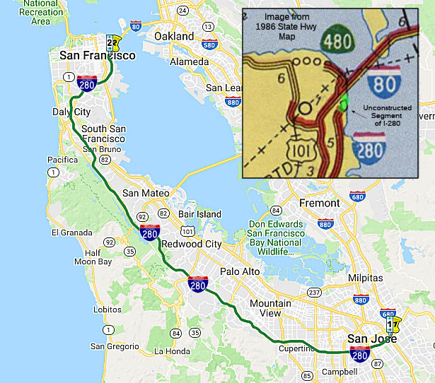 From Route
  Route 279
 Route 281