
 California Highways:
Click here for a key to the symbols used. An explanation of acronyms may be found at the bottom of the page.
 Routing
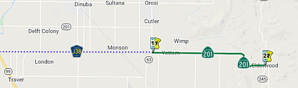
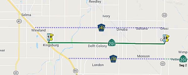 From Route 99 near Kingsburg easterly to Route 63.
 Post 1964 Signage History
This segment remains as defined in 1963.
In 2009, SB 532 (Chapter 189, 10/11/2009) authorized the relinquishment of the portion within the City of Kingsburg by adding:
(b) Upon a determination by the commission that it is in the best interests of the state to do so, the commission may, upon terms and conditions approved by it, relinquish to the City of Kingsburg the portion of Route 201 that is located within the city limits of that city if the city agrees to accept it. The following conditions shall apply upon relinquishment:
(1) The relinquishment shall become effective on the date following the county recorder's recordation of the relinquishment resolution containing the commission's approval of the terms and conditions of the relinquishment.
(2) On and after the effective date of the relinquishment, the relinquished portion of Route 201 shall cease to be a state highway.
(3) The portion of Route 201 relinquished under this subdivision shall be ineligible for future adoption under Section 81.
(4) For the portion of Route 201 that is relinquished under this subdivision, the City of Kingsburg shall install and maintain within the jurisdiction of the city signs directing motorists to the continuation of Route 201.
 Pre 1964 Signage History
This route was LRN 131, defined in 1933. It runs along Conejo Avenue and Avenue 384.
There are four reassurance signs as of 2017, with nary a directional
reassurance sign tag to be found.
(Source: Tom Fearer (Max Rockatansky) on AARoads, January 2017)
 Status
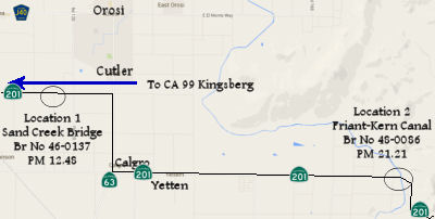
Sand Creek Bridge (PM TUL 12.48) and Friant-Kern Canal Brige (PM TUL 21.21) Project
 In May 2015, the CTC approved for future consideration of
funding a project in Tulare County that will widen the bridges and replace
the railings at Sand Creek Bridge on Route 201 near Cutler, the
Friant-Kern Canal Bridge on Route 201 near Seville, and the Kaweah River
Bridge on Route 216 near Lemon Grove. The project is programmed in the
2014 State Highway Operation and Protection Program. The estimated cost is
$15,298,000 for capital and support. Construction is estimated to begin in
Fiscal Year 2016-17. The scope, as described for the preferred
alternative, is consistent with the project scope programmed by the
Commission in the 2014 State Highway Operation and Protection Program.
In May 2015, the CTC approved for future consideration of
funding a project in Tulare County that will widen the bridges and replace
the railings at Sand Creek Bridge on Route 201 near Cutler, the
Friant-Kern Canal Bridge on Route 201 near Seville, and the Kaweah River
Bridge on Route 216 near Lemon Grove. The project is programmed in the
2014 State Highway Operation and Protection Program. The estimated cost is
$15,298,000 for capital and support. Construction is estimated to begin in
Fiscal Year 2016-17. The scope, as described for the preferred
alternative, is consistent with the project scope programmed by the
Commission in the 2014 State Highway Operation and Protection Program.
In August 2018, it was reported that the CTC approved
the $18.4 million Tulare 201 and 216 Bridge Widening & Rail
Replacement Project, which will replace bridge rail and widen the Sand
Creek Bridge and the Friant-Kern Canal Bridge on Route 201 near the city
of Kingsburg in Tulare County, and the Kaweah River Bridge on Route 216 in
Tulare County.
(Source: Hanford Sentinal, 8/22/2018)
In August 2021, the CTC authorized relinquishment of
right-of-way, consisting of collateral facilities in the county of Tulare
along Route 201 on Road 116 (06-Tul-201-PM 12.5). The County, by
Resolution No. 2021-0433 dated June 8, 2021, agreed to waive the 90-day
notice requirement and accept title upon relinquishment by the
State.
(Source: August 2021 CTC Agenda, Agenda Item 2.3c)
 From Route 63 easterly to Route 245.
Post 1964 Signage History Pre 1964 Signage HistoryThis route was LRN 131, defined in 1933. It runs along Conejo Avenue and Avenue 384.
Route 201 was created out of LRN 131 with only a small stub east of it
becoming Route 216 past Route 245. There are four reassurance signs as of
2017, with nary a directional reassurance sign tag to be found.
(Source: Tom Fearer (Max Rockatansky) on AARoads, January 2017)
StatusIn May 2015, the CTC approved for future consideration of funding a project in Tulare County that will widen the bridges and replace the railings at Sand Creek Bridge on Route 201 near Cutler, the Friant-Kern Canal Bridge on Route 201 near Seville (PM TUL 21.21), and the Kaweah River Bridge on Route 216 near Lemon Grove (see above).
 Other WWW Links
 Statistics
Overall statistics for Route 201:
 Pre-1964 Legislative Route
In 1933, Chapter 767 defined the routes "From a point on [LRN 26] approximately 2 mi W of Brawley to a point on said [LRN 26] approximately 2½ mi SW of Brawley" and "Calipatria to Brawley-Holtville Road" as part of the highway system. In 1935, these routes were added to the highway code as LRN 201, with the definition:
This definition remained unchanged until the 1963 renumbering. It was signed as follows:
© 1996-2020 Daniel P. Faigin.
Maintained by: Daniel P. Faigin
<webmaster@cahighways.org>.
 Route 200
 Route 202