
 California Highways:
Click here for a key to the symbols used. An explanation of acronyms may be found at the bottom of the page.
 Routing
 Post 1964 Signage History
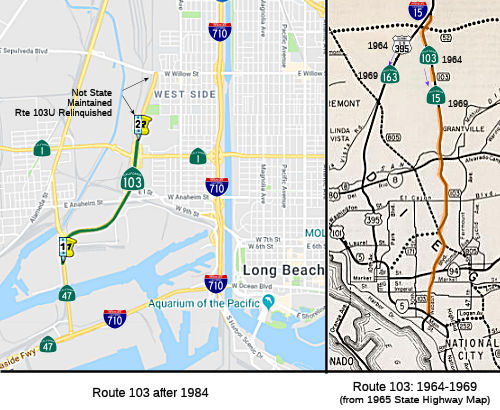
 In 1963, Route 103 was defined as the route from Route 5 to Route 395 near United States Naval Air Station, Miramar. This route was along
Murphy Canyon Road, 40th Street, and Wabash Avenue. In 1969, Chapter 292
transferred this routing to Route 15.
In 1963, Route 103 was defined as the route from Route 5 to Route 395 near United States Naval Air Station, Miramar. This route was along
Murphy Canyon Road, 40th Street, and Wabash Avenue. In 1969, Chapter 292
transferred this routing to Route 15.
In 1984, Chapter 409 redefined the route as "Route 47 in Long Beach
to Route 1." This was a segment dropped from Route 47 in 1982. This route
was signed as Route 47 after 1964, though the alignment of Route 47
actually splits off about ¼ mi north of the drawbridge from Terminal
Island. It represents the original Terminal Island Freeway constructed by
the City of Long Beach.
There were later proposals that extended the Terminal Island Freeway as Route 47 north (i.e., the "Industrial Freeway"—see Route 47 for more information) from its end at Willow Street rather than north of the drawbridge. Route 47 was then switched back to Henry Ford Avenue and Alameda Street in 1982 and the remainder became Route 103 in 1984. The portion of freeway from Route 1 to Willow Street in Long Beach (Sepulveda Blvd on the City of Los Angeles side of the border) is not state highway anymore (technically, it is Route 103U, where U means "unrelinquished") .
The Terminal Island Freeway north of Route 1 was relinquished to the city of Long Beach via trade for the existing freeway corridor, which would become part of I-710 south of Route 1 during August 2000.
In 1986, Chapter 928 corrected the origin to be "Route 47 in Los Angeles". The portion of the route from Route 47 to Pacific Coast Highway is in the City of Los Angeles; the dropped segment N of the Pacific Coast Highway (Route 1) interchange is in the City of Long Beach.
 Pre 1964 Signage History
This was the routing that would eventually be Route 15. It was LRN 283, and was defined as part of the state highway system by 1959.
 What would become Route 103
had its start with a request from the US Navy to the state for access to
the numerous Naval facilities once present on Terminal Island. The Navy
would provde the funds; it would be constructed by the California Division
of Highways. The construction contract was awarded in 1946 for 2.1 miles
between Henry Ford Avenue and Willow Street. Dubbed the "Terminal Island
Access Road Project" the freeway was a $14,000,000 project financed by the
Navy. Construction of the Terminal Island Freeway by the Division of
Highways was requested by Navy to aid in ease of access to their sizable
installations on Terminal Island, and was funded by the Federal
Government. It was not a State Highway. It included a new lift bridge over
Cerritos Channel as a replacement for the existing bascule bridge (the
current 1924 Henry Ford Bridge still in use by the Pacific Harbor Line).
There was also embankment stabilization for the Terminal Island Freeway
grade. There were also plans for a realignment of US 101A/LRN 60 (formerly
State Street) to be a freeway grade design with a full interchange with
the Terminal Island Freeway. The completed freeway first appeared on state
maps in 1948.
What would become Route 103
had its start with a request from the US Navy to the state for access to
the numerous Naval facilities once present on Terminal Island. The Navy
would provde the funds; it would be constructed by the California Division
of Highways. The construction contract was awarded in 1946 for 2.1 miles
between Henry Ford Avenue and Willow Street. Dubbed the "Terminal Island
Access Road Project" the freeway was a $14,000,000 project financed by the
Navy. Construction of the Terminal Island Freeway by the Division of
Highways was requested by Navy to aid in ease of access to their sizable
installations on Terminal Island, and was funded by the Federal
Government. It was not a State Highway. It included a new lift bridge over
Cerritos Channel as a replacement for the existing bascule bridge (the
current 1924 Henry Ford Bridge still in use by the Pacific Harbor Line).
There was also embankment stabilization for the Terminal Island Freeway
grade. There were also plans for a realignment of US 101A/LRN 60 (formerly
State Street) to be a freeway grade design with a full interchange with
the Terminal Island Freeway. The completed freeway first appeared on state
maps in 1948.
(Source: Gribblenation Blog (Tom Fearer): The Terminal Island Freeway (California State Route 103 and California State Route 47))
Against: Note that this was NOT part of the state highway system. In both the 1948 and 1960 maps, although the freeway is shown, there is no LRN indicated.
The first attempt to bring this into the state highway system happened in 1949, when Legislative Chapter 1261 added LRN 231:
“[LRN 165] in San Pedro to [LRN 167] in Long Beach, via the mainland portion of Long Beach Outer Harbor and Terminal Island, subject to the following conditions:
1. Except as provided in paragraph number 2, no expenditure shall be made from state highway funds for the acquisition of rights of way for or construction, improvement, or maintenance of said highway until the following conditions have been met:
(a) The Federal Government shall have made available all funds necessary for the construction of said route, other than funds provided under paragraph 2.
(b) The Federal Government and the Cities of Los Angeles and Long Beach shall have granted a sufficient and adequate right of way without cost to the State of California for that portion of said route traversing lands owned or controlled by each of them.
(c) The authorized representatives of the Cities of Los Angeles and Long Beach and the appropriate agency of the Federal Government shall have approved the proposed alignment and the proposed location of all major structures on the route submitted by the State Department of Public Works.
2. Any city or county may contribute to, and the California Highway Commission may allocate monies from the State Highway Fund for the improvement of portions of [LRN 231] on the mainland when such improvement is found necessary to complete and integrated system of freeways between San Pedro, Long Beach, and the Civic Center in the City of Los Angeles.
3. If funds from sources other than state highway funds have not been made available for the construction on all portions of said [LRN 231] that are not on the mainland prior to January 15, 1953, said [LRN 231] shall on that date cease to be a state highway and this section shall have no further force or effect. ”
 LRN 231
never appeared on state highway maps.
LRN 231
never appeared on state highway maps.
One report indicated that LRN 231 referred to a proposal for a potential
toll highway that would include two channel crossing from San Pedro to
Terminal Island, and from Terminal Island to Long Beach. These were
planned to be tube crossings, with the San Pedro-Terminal Island tube
estimated at $10 million. The other tube had a similar estimate, but
financing was not possible at the time. It appears that the tube concept
was later dropped, to be replaced by a bridge.
(Source: 1956 Report to the California Toll Bridge Authority on a Proposed Toll Highway Crossing of Los Angeles Harbor from San Pedro to Terminal Island)
But there were more details provided in a 1951 issue of CHPW. It
displayed the alignment of the proposed extension of the Terminal Island
Freeway to the Los Angeles River Freeway and noted that the Navy was
responsible for funding the extension of the Terminal Island Freeway to
the Los Angeles River Freeway via LRN 231.
(Source: Gribblenation Blog (Tom Fearer): The Terminal Island Freeway (California State Route 103 and California State Route 47))
What is likely is that both items are correct. Note that the definition of LRN 231 has two distinct portions: the mainland portion and the Terminal Island portion. The mainland portion would not be funded by the state: the Federal Government, the city of Long Beach, or the city of Los Angeles would have to provide the funds. If those funds were not provided by 1953 (although there is the confusing "...not on the mainland..."), the highway goes poofta. In reality, the funds never appeared, and so (a) the connection to the Los Angeles River Freeway was never made, and (b) the Terminal Island Freeway remained a Federal freeway, not part of the state system.
In 1959, a portion of the route did become part of the state system: the portion along Henry Ford that was incorporated into Route 47. LRN 270 was defined at this time as "Terminal Island to [LRN 173]”. This was the proposed "Industrial" Freeway, Route 47 from Terminal Island to I-10. " This did not include the Route 103 portion, but incorporated the existing Terminal Island Freeway over the Commodore Schuyler F. Heim Lift Bridge.
Note that the routing, even disconnected from the state highway system, still makes sense. Trucks would be along US 6 / US 101A, fed by Route 11 and Route 15, and would use this route to get into the main part of terminal island, which was not connected to either San Pedro or Long Beach.
Signed Route 103 was not defined as part of the initial state signage of routes in 1934. It is unclear what (if any) route was signed as Route 103 between 1934 and 1964.
 Status
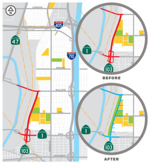
Terminal Island Freeway Removal (Former Rte 103U N of Rte 1 to Willow)
In March 2012, it was reported that the Long Beach City Council voted to seek a grant that would study a proposal to remove the Terminal Island Freeway. The plans are still very preliminary. The goal of local advocates is to turn the freeway into a local street and a large park. The council vote means the city will officially pursue a $300,000 Caltrans grant under the Transportation Planning Grant Program. The section of freeway targeted for removal is on city-owned land, so if the freeway is removed, according to the Long Beach Post, "the surplus land size falls in the arena of some 25-acres that could be used to create a mile-long greenbelt, similar to the Wilmington Park Yards proposal."
In March 2013, the Long Beach City Council tried again.
They voted unanimously to (once again) approved a motion to pursue a grant
in order to further a study on the removal of the northern portion of the
Terminal Island Freeway (Route 103) that sits above Pacific Coast Highway
in West Long Beach. The Terminal Island Freeway has been at the center of
a proposed restructuring since 2010, when community leaders pointed out a
simple thing: the existing northern length of the freeway, following the
development of the 20-mile long Alameda Corridor and the still-underway
modernization of the Intermodal Container Transfer Facility (ICTF) by
Union Pacific Railroad, is redundant. Not only do shipping companies use
it less and less, the traffic itself matches those of 4th Street along
Retro Row (some 13,700 AADT). And if plans for ICTF follow through, you
can drop that down to 8,700 AADT–less than the traffic 3rd Street
receives in the quiet neighborhood of Alamitos Beach.
(Source: LA Streets Blog)
In July 2014, it was reported that, funded by a grant from the California Department of Transportation, Long Beach released an RFP for conceptual and design services for a plan to transform the Terminal Island Freeway into a "regional serving greenbelt and local serving road."
 In December 2014, it was reported that a contractor has
been selected to remove the Route 103 freeway: Meléndrez, the same
company responsible for the MyFigueroa project in LA and the Bixby Park
re-design. The project is simple: the existing northern length of the
freeway, following the development of the 20-mile long Alameda Corridor
and the still-underway modernization of the Intermodal Container Transfer
Facility (ICTF) by Union Pacific Railroad, is redundant. Not only do
shipping companies use it less and less, the traffic itself matches those
of 4th Street along Retro Row (some 13,700 AADT). And if plans for ICTF
follow through, that can drop that down to 8,700 AADT–less than the
traffic 3rd Street receives in the quiet neighborhood of Alamitos Beach.
According to the bid, the “TI Freeway Transition Plan will define
the community’s vision for replacing an underutilized freeway to
mitigate pollution impacts to address long-standing community health
concern” while giving “qualified candidates the opportunity to
produce a plan for one of the most heavily impacted communities in
Southern California.” What Meléndrez proposed is using the TI
project as a tie to the larger West Long Beach Livability Implementation
Plan, a plan dedicated to prioritize various proposed planning projects
based on their ability to increase overall livability of the West Long
Beach community. It combines a variety of key planning elements—Port
of Long Beach Green Port Policy, Mobility Element, Community Livability
Plan: I-710 Corridor Neighborhoods, Long Beach RiverLink, The Yards
Westside Plan, Open Space and Recreation Element and the 2013-2121 Housing
Element—to assess how to improve the Westside as a whole through the
TI project.
In December 2014, it was reported that a contractor has
been selected to remove the Route 103 freeway: Meléndrez, the same
company responsible for the MyFigueroa project in LA and the Bixby Park
re-design. The project is simple: the existing northern length of the
freeway, following the development of the 20-mile long Alameda Corridor
and the still-underway modernization of the Intermodal Container Transfer
Facility (ICTF) by Union Pacific Railroad, is redundant. Not only do
shipping companies use it less and less, the traffic itself matches those
of 4th Street along Retro Row (some 13,700 AADT). And if plans for ICTF
follow through, that can drop that down to 8,700 AADT–less than the
traffic 3rd Street receives in the quiet neighborhood of Alamitos Beach.
According to the bid, the “TI Freeway Transition Plan will define
the community’s vision for replacing an underutilized freeway to
mitigate pollution impacts to address long-standing community health
concern” while giving “qualified candidates the opportunity to
produce a plan for one of the most heavily impacted communities in
Southern California.” What Meléndrez proposed is using the TI
project as a tie to the larger West Long Beach Livability Implementation
Plan, a plan dedicated to prioritize various proposed planning projects
based on their ability to increase overall livability of the West Long
Beach community. It combines a variety of key planning elements—Port
of Long Beach Green Port Policy, Mobility Element, Community Livability
Plan: I-710 Corridor Neighborhoods, Long Beach RiverLink, The Yards
Westside Plan, Open Space and Recreation Element and the 2013-2121 Housing
Element—to assess how to improve the Westside as a whole through the
TI project.
(Source: LongBeachIze, 11/26/2014)
In October 2015, it was reported that the City of Long
Beach has disclosed conceptual plans to decommission Route 103 that have
been in development for two years. It was the first time the plans,
developed from a series of community meetings, have been shown publicly.
The city plans to decommission one side of the freeway, leaving a reduced
set of lanes to serve as a local access road. There will be green park
space, a small section of wetland, pedestrian bridges and walking trails,
among other features. Residents should expect these plans to change as the
project progresses; an environmental review or a traffic study has not yet
been performed. The Green Terminal Island Freeway Transition Plan, as it
is known in project parlance, began in October 2013, when Caltrans awarded
Long Beach a $225,000 environmental justice grant. The project is
considered one of Southern California’s largest freeway-removal
projects.
(Source: Press-Telegram, 10/24/2015)
In December 2015, it was reported that the Long Beach
City Council voted unanimously in favor of further traffic and
environmental impact studies. After nearly two hours of debate between
community members and activists pushing for a more green entity to be
installed in the city and an “unprecedented” coalition of
labor unions and port businesses voicing opposition to the removal of
vital infrastructure for port-bound goods, the council decided that more
information regarding possible impacts on traffic, health and the economy
were needed before they could take a side in the matter. The biggest
causes for concern, voiced by both sides of the issue and the city
council, was the lack of in-depth studies, like how traffic would be
impacted, and the absence of an environmental impact report. Because the
plan is still in its conceptual phase, it did not require those, but those
studies will be required prior to any kind of vote to approve the project.
(Source: Long Beach Post, 12/2/2015)
 Naming
This route is named the "Terminal Island Freeway". The first segment opened in 1948. Terminal Island was originally named "Isla Raza de Buena Gente" (Island of the Race of Good People). Early in the American era, the island became known as Rattlesnake Island. In 1911, after the Los Angeles Terminal Railway had built a line from the city to the island, it assumed its present name.
 Other WWW Links
 Freeway
[SHC 253.1] Entire route. Added to the Freeway and Expressway system in 1959.
 Statistics
Overall statistics for Route 103:
 Pre-1964 Legislative Route
In 1933, Chapter 767 added the route from "Calistoga to [LRN 1] near Geyserville" to the highway system. In 1935, this was codified as LRN 103 in the highway code with the following definition:
Calistoga to [LRN 1] near Geyserville
In 1959, Chapter 1841 changed the definition to "[LRN 1] near Geyserville to [LRN 49] near Calistoga".
This route ran from US 101 near Geyserville to the present-day Route 128/Route 29 junction (former Route 53/Route 128/Route 29 junction) near Calistoga. This was signed as Route 128.
© 1996-2020 Daniel P. Faigin.
Maintained by: Daniel P. Faigin
<webmaster@cahighways.org>.
 FromRoute
  Route 102
 Route 104