
 California Highways:
Click here for a key to the symbols used. An explanation of acronyms may be found at the bottom of the page.
 Routing
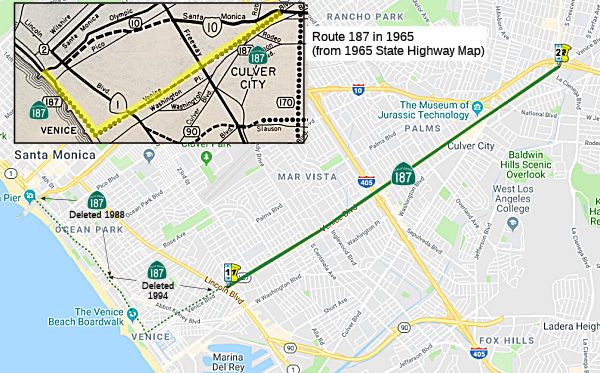 (a) From Lincoln Boulevard to Route 10 via Venice Boulevard.
(b) Upon a determination by the commission that it is in the best interest of the state to do so, the commission may, upon terms and conditions approved by it, relinquish to the City of Los Angeles Route 187 within the city between the route’s western terminus at Lincoln Boulevard (approximately postmile 3.5) and its eastern terminus at Cadillac Avenue near Route 10 (approximately postmile 8.9), if the department and the city enter into an agreement providing for that relinquishment. The following conditions shall apply upon relinquishment:
(1) The relinquishment shall become effective on the date following the county recorder’s recordation of the relinquishment resolution containing the commission’s approval of the terms and conditions of the relinquishment.
(2) On and after the effective date of the relinquishment, Route 187 shall cease to be a state highway.
(3) Route 187, as relinquished under this subdivision, shall be ineligible for future adoption under Section 81.
SB 177, Chapter 106, 1988 contains special legislation to improve the traversable route.
 Post 1964 Signage History
In 1963, Route 187 was defined as the route "Route 1 at a point near Colorado Avenue in Santa Monica to Route 10 via Pacific Avenue and Venice Boulevard; provided that prior to the construction of any portion of this highway the City of Los Angeles shall furnish to the State of California without charge all right-of-way necessary for that portion and the City of Los Angeles and the County of Los Angeles shall enter into a co-operative agreement with the department wherein said city and county agree to pay one-half the cost of plans and construction."
Note that the grade separation here (what is now Moomat Ahiko Way) is part of the eastern-most portion of the Santa Monica pier.
In July 1965, the CTC adopted a conventional highway routing for Route 187 that will carry traffic along Venice Boulevard for 2.8 miles, between east of Sepulveda Boulevard at the Los Angeles-Culver City border and the Santa Monica Freeway, just east of La Cienega Boulevard in Los Angeles.
In 1988, Chapter 106 deleted the Santa Monica portion of the route,
retaining the conditions: "Route 1 at a point near Colorado Avenue
in Santa Monica the South city limits of Santa Monica near
Dewey Street to Route 10 via Pacific Avenue and Venice Boulevard;
provided…"
In 1994, AB 3132, Chapter 1220 deleted the portion from the South city limits of the City of Santa Monica to Lincoln Boulevard, changing the origin to "Lincoln Boulevard". It is unclear why they did not identify Lincoln Boulevard as Route 1.
Note that the bridge log shows a junction with Route 1 at the McClure Tunnel. This dates back to the original 1964 definition of the route, and represents that Santa Monica Pier bridge.
In 2015, AB 810 (Chapter 561, 10/07/15) authorized relinquishment of a specified portion of Route 187 to the City of Los Angeles by adding:
(b) Upon a determination by the commission that it is in the best interest of the state to do so, the commission may, upon terms and conditions approved by it, relinquish to the City of Los Angeles Route 187 within the city between the route’s western terminus at Lincoln Boulevard (approximately postmile 3.5) and its eastern terminus at Cadillac Avenue near Route 10 (approximately postmile 8.9), if the department and the city enter into an agreement providing for that relinquishment. The following conditions shall apply upon relinquishment:
(1) The relinquishment shall become effective on the date following the county recorder’s recordation of the relinquishment resolution containing the commission’s approval of the terms and conditions of the relinquishment.
(2) On and after the effective date of the relinquishment, Route 187 shall cease to be a state highway.
(3) Route 187, as relinquished under this subdivision, shall be ineligible for future adoption under Section 81.
AB 810 (Chapter 561, 10/07/15) also deleted the special words regarding construction restrictions:
Note that, with respect to this routing,
prior to the construction of any portion of this highway, the City of
Los Angeles shall furnish to the State of California without charge all
right-of-way necessary for that portion and the City of Los Angeles and
the County of Los Angeles shall enter into a cooperative agreement with
the department wherein the city and the county agree to pay one-half the
cost of plans and construction. The title to that portion of the
right-of-way acquired by the City of Los Angeles, and furnished to the
State of California, for Route 187, but not needed for that route upon
its construction, has been to the city.
In October 2016, the CTC authorized relinquishment of the right of way in the city of Los Angeles on Route 187 (Venice Boulevard) from Route 1 (Lincoln Boulevard) to Route 10 (Santa Monica Freeway/Cadillac Avenue), under terms and conditions as stated in the relinquishment agreement dated September 1, 2016, determined to be in the best interest of the State. Authorized by Chapter 561, Statutes of 2015, which amended Section 487 of the Streets and Highways Code. Furthermore, the CTC authorized 14,500,000 to be allocated from the Budget Act of 2016, Budget Act Item 2660-302-0042, to provide funds for relinquishment in lieu of rehabilitating the pavement with a Capital Preventative Maintenance pavement project. The construction capital for this project is currently programmed in the 2014 SHOPP for $10,500,000 as a Capital Preventive Maintenance pavement project. This allocation request of $14,500,000 is an increase of 38.1 percent above the programmed amount. The Department and the City of Los Angeles entered into a relinquishment agreement, under Resolution R-3958 to relinquish Route 187 to the City of Los Angeles, in lieu of implementing the programmed Capital Preventive Maintenance pavement project. The City of Los Angeles estimated the value of relinquishment of the facility as $21,500,000. The Department in negotiations with the City of Los Angeles mutually agreed upon with the amount of $14,500,000 for the relinquishment. The Department has concluded that relinquishing Route 187 to the City of Los Angeles is in the best interest of the State. The City of Los Angeles will assume full maintenance ownership responsibility, control and liability in perpetuity over the relinquished facilities.
The route still showed in the Caltrans postmile tool at the end of 2018. However, as of 2022, the route no longer shows in the Postmile Tool.
 Pre 1964 Signage History
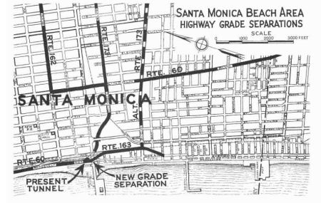 In 1933, Chapter 767 defined the following route as part of the state highway
system:
In 1933, Chapter 767 defined the following route as part of the state highway
system:
"Continue Roosevelt Highway from the point where it intersects with Santa Monica Canyon Road at and in Santa Monica to a point where, if so continued, it would intersect with Windward Avenue in Venice, Los Angeles, California. Said road is now commonly known and designated as Ocean Front and parallels the Pacific Ocean a short distance therefrom."
In 1935, this was added to the highway code as LRN 163, with the routing:
"[LRN 60] in Santa Monica, at the point where [LRN 60] leaves the ocean, to Windward Avenue in Venice via a road commonly known and designated as Ocean Park"
However, this was rapidly amended later in 1935 by Chapter 274 to be:
"[LRN 60] in Santa Monica, a a point southerly of the westerly extension of Wilshire Boulevard in Santa Monica to Windward Avenue in Venice via Prominade in Santa Monica and Ocean Front Walk in the City of Los Angeles"
In 1937, Chapter 50 reworded the definition for LRN 163 again:
"[LRN 60] at a point near Colorado Avenue in Santa Monica to a connection with Windward Avenue in the city of Los Angeles"
1939 saw the planning start for the Colorado Avenue Grade Separation,
which would include the first constructed segment of LRN 163. The
Colorado Avenue Grade Separation project was a cooperative project between
Public Works Administration and Division of Highways; it was designed out
of a need to relieve traffic overflowing onto US 101A/LRN 60 in Santa
Monica. LRN 163 would be constructed underneath Colorado Avenue (via
what is now Moomat Ahiko Way), and would connect US 101A/LRN 60 to Ocean
Avenue. The Colorado Avenue Grade Separation was completed in July
1940.
(Source: Gribblenation Blog (Tom Fearer), “California State Route 187”, May 2022)
The pre-1961 routing did not involve Venice Blvd. The route was a connection along the coast between the constructed LRN 173 (Olympic Blvd) and the alternate LRN 173 (Pico Blvd). It provided a highway closely following the ocean-front between Santa Monica and Venice. The 1937 routing involved the street currently called Moomat Ahiko Way (the curved road going under the bridge to the Santa Monica Pier, which was built by the state), and Ocean Blvd. The route continued S along Neilson and Pacific to Windward, which is a few blocks N of Venice.
In 1961, Chapter 1840 extended the LRN 163 to LRN 173: "… to a
connection with Windward Avenue in the city of Los Angeles LRN 173 via Pacific Avenue and Venice Boulevard". At this time, LRN 173
was the eventual freeway routing of I-10.
It was not signed until 1988. Route 187 was not included in the initial set of state signed routes in 1934.
 Naming
Maps based on the 1956 freeway plan show this route as the "Venice Freeway". It was named after the community of Venica, CA, founded by Abbot Kinney in 1904 as part of his Ocean Park tract, envisioning it as an imitation of Venice, Italy.
 Status
 Not completely signed.
Venice Road Diet
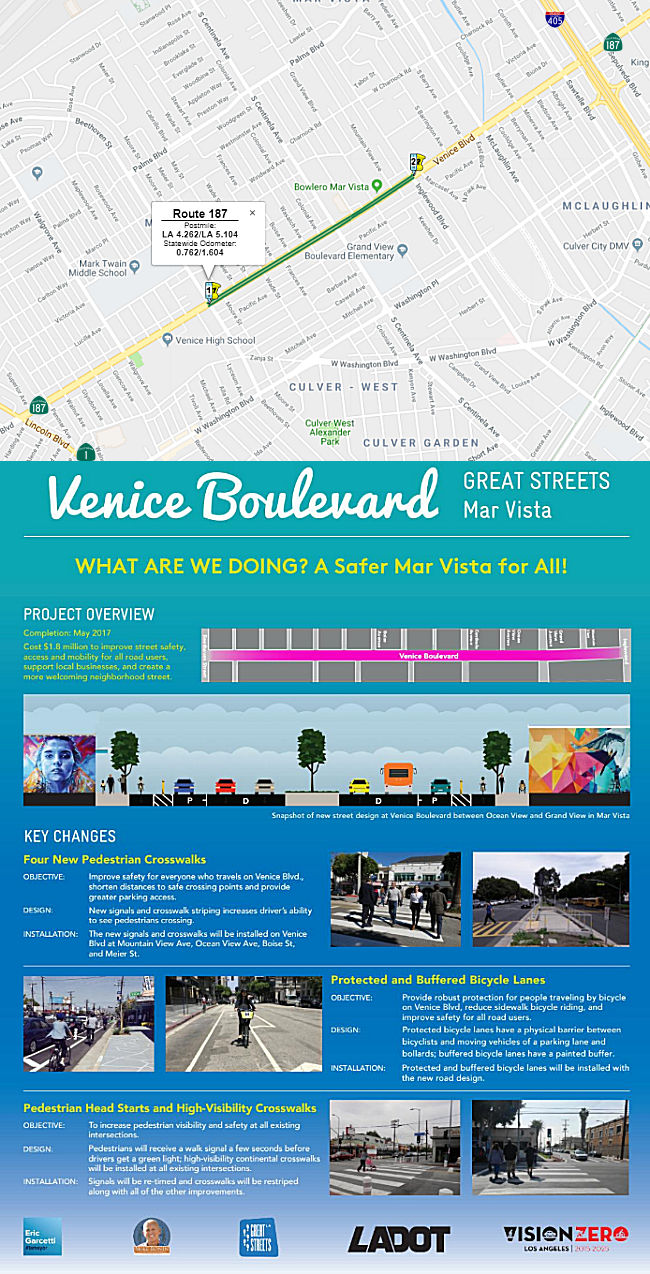 Since 2015 a community outreach process facilitated by Councilmember Mike Bonin
and the Great Streets Initiative has culminated in changes focused on
making Venice Boulevard safer for people who travel the corridor and
supporting local businesses. As part of Los Angeles’s Great Streets initiative, in May 2017 Venice Blvd was reworked to provide four new pedestrian crossings, a safer road design
featuring protected and buffered bike lanes, and improvements at existing
signalized intersections. This project reconfigured the stretch of road
between Beethoven Street and Inglewood Avenue, reducing the number of
automobile lanes from three to two in each direction. At the same time,
the city’s transportation department added multiple turn lanes,
high-visibility crosswalks, and protected bike lanes running the length of
the corridor. According to the Great Streets website, the following is a summary of the other changes made (Venice Blvd Fact Sheet):
Since 2015 a community outreach process facilitated by Councilmember Mike Bonin
and the Great Streets Initiative has culminated in changes focused on
making Venice Boulevard safer for people who travel the corridor and
supporting local businesses. As part of Los Angeles’s Great Streets initiative, in May 2017 Venice Blvd was reworked to provide four new pedestrian crossings, a safer road design
featuring protected and buffered bike lanes, and improvements at existing
signalized intersections. This project reconfigured the stretch of road
between Beethoven Street and Inglewood Avenue, reducing the number of
automobile lanes from three to two in each direction. At the same time,
the city’s transportation department added multiple turn lanes,
high-visibility crosswalks, and protected bike lanes running the length of
the corridor. According to the Great Streets website, the following is a summary of the other changes made (Venice Blvd Fact Sheet):
The changes were first instituted as part of a year-long pilot project aimed at cutting down on deadly crashes. Collision data gathered by the city show that between 2003 and 2016, 360 injuries and five traffic deaths were reported on the 0.8-mile segment of Venice Boulevard. A report on the pilot compiled by transportation consultant Fehr and Peers found that no serious injuries or deaths had occurred during the 12-month trial period. The report was released in December and soon after, the transportation department announced that the project’s lane reconfiguration would become permanent.
According to the Fehr and Peers report, travel times in the eastbound direction increased significantly after the project was implemented, though they came down after a left-turn lane was added at Centinela Avenue. In September, it took roughly 1 minute and 30 seconds longer to travel the eastbound route during peak afternoon hours than it did in 2015. Trip lengths before and after the project were much closer in the westbound lanes. Typical vehicle speeds also haven’t changed much. Drivers heading east traveled 1 mile per hour slower after the changes; those going west went faster by 2 miles per hour.
In March 2019, it was reported that Los Angeles City
Council unanimously rejected an appeal Tuesday from critics of a
polarizing streetscape project that’s transformed just under one
mile of Venice Boulevard in Mar Vista. In the estimation of Councilmember
Mike Bonin, who represents the area, the lane reductions and pedestrian
safety measures implemented as part of the project have been a success.
Opponents of the project see things differently. Mar Vista Community
Council member Mary Hruska told the committee that the road
reconfiguration had “ignited a feud which has riven our formerly
placid and welcoming neighborhood apart.”
(Source: Curbed LA, 3/8/2019)
Santa Monica Pier
In December 2013, it was reported that the Santa Monica City Council was looking closely at the impact some of the plans to replace the “structurally deficient” concrete bridge, which connects Colorado Avenue to the historic Santa Monica Pier. There was particular concern that the new bridge allow people of all abilities equal access to the Santa Monica Pier. The future of the Pier Bridge, built in 1939 by the California Department of Highways, has been a topic of discussion for nearly 20 years in Santa Monica. Prior to August 2010, the plan was to rehabilitate the bridge; the decision to replace was made in August 2010. In a 2010 survey, the bridge received a 30.6 sufficiency rating on a 100-point scale. Caltrans says it has inadequate seismic strength, crumbling concrete and cracks in the deck. Also, the sidewalks are too narrow and it has steep curbs and substandard lane widths. The replacement project is eligible for nearly 90 percent federal funding. In the next step, City planners will move forward with environmental impact studies required by both State and national law, a process they said can last from 18 to 24 months.
In January 2018, it was reported that the Santa Monica City Council and Caltrans were holding meetings to discuss the replacement of the Santa Monica Pier bridge. The more than $8 million project comes after the California Department of Transportation deemed the bridge “structurally deficient” and “functionally obsolete.” The City had planned to rehabilitate the the bridge built in 1939, but decided in August 2012 to rebuild the structure after Caltrans said rehabilitation would not be cost-effective and did not qualify for federal funding. The Pier Bridge Replacement Project approved by the Council is eligible for nearly 90 percent federal funding. The project will replace the structure -- which received a 30.6 sufficiency rating on a 100-point scale from Caltrans -- with either a single bridge or two separate bridges. The Environmental Impact Report/Environmental Assessment (EIR/EA) for the proposed project explores the three following options:
To make the current bridge safer, in 2013 the City
added a designated walkway that separates pedestrians from bike and
vehicle traffic as part of $150,000 in improvements.
(Source: SM Lookout, 1/2/2018)
Later in January 2018, it was reported that City of
Santa Monica staff have recommended replacing the current 1939 pier bridge
with two separate bridges: one for automobiles, and one for pedestrians
and bikes. A new 40-foot bridge would connect pedestrians and bikers to
the pier from Colorado Avenue. Emergency vehicles and delivery trucks may
use the span during off-peak hours. A lower, second bridge would allow
cars to access pier parking from Moss Avenue. The bridge would be span 150
feet over Ocean Front Walk where restaurants currently are located, with
two vehicle lanes separated by barriers. The construction would be done in
stages, so that the pier would always be accessible. All options would
either construct an elevator for handicapped visitors, or a separate ADA
walkway cantilevered from the side of the bridge.
(Source: SM Observer, 1/5/2018)
In June 2021, it was reported that after decades of
discussions, reports, analysis and funding attempts, time is running out
to fix the bridge connecting the Santa Monica Pier to Palisades Park
before the facility becomes part of an Olympic venue in 2028. Repairs on
the Bridge are important because it’s structural safety continues to
decline. In 2008 the bridge scored 33.4 out of 100 on an inspection report
and its score declined to a 17 in 2020. In addition, officials want all
construction finished before Los Angeles hosts the Summer Olympics in 2028
because Olympic organizers have suggested the Pier could be incorporated
into a beach volleyball venue for the event. In a report released in June
2021, City staff have concluded anything but the most basic of bridge
replacement options would jeopardize funding from state or federal sources
while also delaying the process by an additional two years which could
push construction timeline into the Olympics. To meet the various goals,
the city will jettison several ideas for an offset pedestrian walkway and
eliminate any possibility of installing elevators to improve access.
Planners are now pursuing three basic options: widen the bridge slightly
on the left, widen it slightly on the right, or do nothing. Plans to
rebuild the bridge began more than 30 years ago but stalled due to a lack
of federal funding. Efforts were renewed in earnest in 2006 but those
plans were rejected by Caltrans. City staff were eventually able to secure
federal funding for the replacement project in 2012 but environmental
documents to support the initial plans were derailed by historic
preservation efforts including the establishment of a scenic corridor
along Ocean Front Walk and landmarking Carousel Park adjacent to the Looff
Hippodrome. When staff began work on revised environmental documents, they
incorporated desires from various stakeholders that the pedestrian and
vehicle elements of the new bridge be separated by a physical barrier. The
plans also included the possibility of elevators near the base of the Pier
to increase disabled access. However, construction of elevator towers
would obscure views of the Looff Hippodrome and no matter what mitigation
measures were implemented, staff said federal law would likely prevent
installation of any element that violated the historic integrity of the
Pier. Elevators and walkways would also add up to $10 million to
construction costs. The EIR noted that “Based upon recently updated
technical studies, consultations with Caltrans, and a comparison of the
options, it is evident that including alternatives with elevators in the
REIR/EA would jeopardize both the Project schedule and federal funding
(currently programmed for $27,225,000 in total)”. Instead, staff
will complete the environmental documents without the possibility of
elevators and pursue a construction schedule to finish work before the
summer of 2028.
(Source: Santa Monica Daily Press, 6/21/2021)
 Other WWW Links
 Statistics
Overall statistics for Route 187:
 Pre-1964 Legislative Route
In 1933, Chapter 767 added the following routes to the highway system:
In 1935, these routes were added to the highway code with the following routing:
In 1959, Chapter 1062 extended segment a to "[LRN 43] near Lucern Valley via Monongo Valley", and corrected the spelling of White Water.
Signage on this route was as follows:
This is present-day Route 62 to Yucca Valley, and Route 247 to Lucerne Valley.
This is Route 111.
This was Route 115 until 1973.
© 1996-2020 Daniel P. Faigin.
Maintained by: Daniel P. Faigin
<webmaster@cahighways.org>.
 Route 186
 Route 188