
 California Highways:
Click here for a key to the symbols used. An explanation of acronyms may be found at the bottom of the page.
 Routing
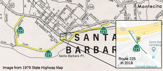 From Route 101 near Santa Barbara to near the Santa Barbara Central Business
District.
From Route 101 near Santa Barbara to near the Santa Barbara Central Business
District.
Note: The CTC is permitted to relinquish the entirety of this route within the jurisdiction of the city of Santa Barbara, between the Route 101/Route 225 separation at Las Positas Road and the Castillo Street interchange with Route 101, on terms and conditions that the commission finds to be in the best interests of the state. This segment was relinquished in December 2013.
 Post 1964 Signage History
In 1963, this route was defined as “Route 101 near Santa Barbara to Route 101 near Montecito via the coast.”
In 1998, AB 2132, Chapter 877, signed September 26, 1998 truncated the
route to be "Route 101 near Santa Barbara to Route 101 near the
Santa Barbara Central Business District Montecito via the
coast". Now, rather than following Cabrillo Boulevard along the
beach area, the route turns left at Castillo Street and ends at Castillo
and US 101.
In 2011, AB 957 (Chapter 536, 10/7/2011) permitted the CTC to "relinquish to the City of Santa Barbara the entire Route 225 within the jurisdiction of the city, between the Route 101/Route 225 separation at Las Positas Road and the Castillo Street interchange with Route 101, on terms and conditions that the commission finds to be in the best interests of the state, if the department and the city enter into an agreement providing for that relinquishment. The following conditions shall apply upon relinquishment: (1) The relinquishment shall become effective on the date following the county recorder's recordation of the relinquishment resolution containing the commission's approval of the terms and conditions of the relinquishment. (2) On and after the effective date of the relinquishment, Route 225 shall cease to be a state highway and shall be ineligible for future adoption under Section 81.
In December 2013, the CTC authorized relinquishment of right of way in the city of Santa Barbara on Route 225 between the Route 101/Route 225 separation at Las Positas Road and the Castillo Street interchange with Route 101, under terms and conditions as stated in the relinquishment agreement dated May 21, 2013, determined to be in the best interest of the State. Authorized by Chapter 536, Statutes of 2011, which amended Section 525 of the Streets and Highways Code.
As of 2022, the 2018 segment of Route 225 was no longer in the Caltrans Postmile GIS database.
 Post the December 2013 relinquishment, this becomes an unconstructed route as it appears the entirety of the route has been
deleted. Caltrans could define a new route with the same endpoints until
the legislative definition is updated. Note: These pages won't show the
route as unconstructed, however, as signage likely remains.
Post the December 2013 relinquishment, this becomes an unconstructed route as it appears the entirety of the route has been
deleted. Caltrans could define a new route with the same endpoints until
the legislative definition is updated. Note: These pages won't show the
route as unconstructed, however, as signage likely remains.
 Pre 1964 Signage History
This route was LRN 150, defined in 1933.
 Status
In July 2024, it was reported that work was continuing on construction
for the Cabrillo Boulevard-Los Patos Way Roundabout Project, which began
in February and is set to finish in spring 2025. Cabrillo Blvd is former
Route 225. It’s the first phase of a larger project along East
Cabrillo Boulevard between Los Patos Way and the Cabrillo interchange,
which includes the construction of a single-lane roundabout at the
intersection of East Cabrillo Boulevard and Los Patos Way. The second
phase will include replacing the Union Pacific Railroad bridge over East
Cabrillo Boulevard and pedestrian and bicycle improvements. Before
construction began, the intersection at East Cabrillo Boulevard and Los
Patos Way had only a two-way stop. The city also is working to replace the
railroad bridge that goes over East Cabrillo Boulevard. The project is
currently in the design phase, it is unclear when construction will begin
but that it will be coordinated with the US 101 project. The Santa Barbara
north segment of the US 101 project will include reconstruction of the
Cabrillo interchange. That segment is in the design phase, and
construction is set to start in early 2026, if the county receives funding
for it. The county won’t know whether it received funding until June
2025.
(Source: Noozhawk, 7/3/2024)
 Other WWW Links
 Statistics
Overall statistics for Route 225:
 Pre-1964 Legislative Route
In 1947 (1st Ex Sess), Chapter 11 defined LRN 225 as the route “a connection between [LRN 56] and [LRN 2] near the south boundary of the City and County of San Francisco”.
This route ran from Route 1 to US 101 near the S boundary of San Francisco. This was once proposed as part of I-280.
© 1996-2024 Daniel P. Faigin.
Maintained by: Daniel P. Faigin
<webmaster@cahighways.org>.
 Route 224
 Route 226