
 California Highways:
Click here for a key to the symbols used. An explanation of acronyms may be found at the bottom of the page.
 Routing
 Post 1964 Signage History
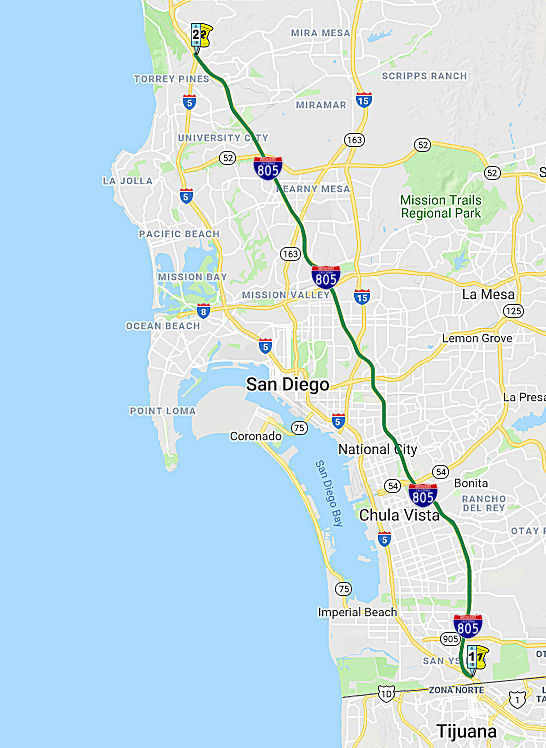
This route remains as defined in 1963. Construction on the route began in 1966 with the 3.6 mi segment between 0.2 mi N of Home Ave and I-5. This route was completed in 1975.
On September 25, 1967 a groundbreaking ceremony was held at El Cajon
Boulevard and Boundary Street in San Diego for I-805. Planning for that
route dated back to 1956. After the groundbreaking ceremony, I-805 was
constructed in phases. It was completed in 1975.
(Source: Transportation History, 9/25/2020)
Bidding for construction began in May 1967, after it had been delayed by
construction on the I-5 and I-8 interstate highways, both of which had
been given higher priority. I-805 was to constructed in phases, and the
first section was built from Wabash Boulevard to around Madison Avenue (a
distance of 3.5 miles), and the next section to be constructed would
include the I-8/I-805 interchange. The low bid for the first section was
$11.7 million ($71 million in 2022 dollars). In August 1968, the section
of I-805 from just south of I-8 to north of Friars Road, including the
interchange with I-8, was put up for bidding; budgeted at $27.5 million
(equivalent to $160 million in 2022), it was the most expensive job that
the California Division of Highways had ever put up for bid. Construction
continued in phases. In September 1969 planners were concerned that an
order from President Richard Nixon to reduce federal construction projects
by 75% might impact funding for the highway. However, Governor Ronald
Reagan ended an associated freeze in construction at the state level a few
weeks later. On July 6, 1970, the first section of the highway (between
Home Avenue and near I-8) was dedicated, and opened from El Cajon
Boulevard to Wabash Boulevard soon thereafter. The Chula Vista portion of
the freeway from Main Street to L Street was completed in February 1971;
however, the estimated date for completing I-805 in its entirety had
slipped to 1975 from 1972.
(Source: Freightwaves Classic, 9/26/2022)
By 1974, I-805 was open north of Home Avenue, and from Otay Valley Road
to Telegraph Canyon Road in Chula Vista; five remaining segments were
under construction, and the last segment was funded. I-805 between Route 15 and Route 94 was opened to traffic in late January. The dedication of
I-805 was held on July 23, 1975, even though the highway was not entirely
finished (state and local officials wanted to hold the ceremony during the
summer). I-805 from Plaza Boulevard to Telegraph Canyon Road opened to
traffic on July 28; the highway was complete except for the portion
between Plaza Boulevard and Route 94. On September 3, 1975, it was
announced that the full length of the highway would open the next day. The
total cost to build the original version of I-805 was $145 million (over
$550 million today).
(Source: Freightwaves Classic, 9/26/2022)
There was once an Immigration Warning Sign (i.e., about people running across the road) at the I-5/I-805 split near the border. For more information on these warning signs, see I-5.
In San Diego, the I-805 routing runs along the border of what was once
East San Diego and San Diego (the two later merged). Boundary Street, the
former dividing line, now acts as a frontage road for portions of I-805
between Route 94 and I-8.
(Source: AARoads Interstate Guide I–805)
Construction of a “dual freeway” at the northern end of I-805
had been recommended as early as 1989. A dual freeway refers to the
two-lane carriageways needed for each direction of the highway, resulting
in four lanes total. The plans required drivers to use new local lanes to
access eastbound Route 56 from I-5 or I-805. The project allowed trucks to
use the new lanes to assist traffic to merge. Although it faced opposition
from local residents and environmentalists, the San Diego Association of
Governments (SANDAG) funded the expansion construction in mid-2000.
Construction began in early 2002; the northbound lanes opened in February
2006 and the southbound lanes were finished in early 2007.
(Source: Freightwaves Classic, 9/26/2022)
The American Society of Civil Engineers (ASCE) recognized the Mission
Valley Viaduct as the “Outstanding Civil Engineering Project for
1973 in the San Diego Area.” It was designed to match the nearby
Mission San Diego de Alcalá, whose columns look similar to cathedral
windows, and arch-like shapes were etched into the textured concrete. The
viaduct was designed to span 3,900 feet, and use squared-off support
columns instead of traditional cylindrical supports. Octagonal columns
were used on the ramps and the ends of the bridge. Over 600 tons of steel
bars were used, and the bridge was built as high as 98 feet above I-8.
(Source: Freightwaves Classic, 9/26/2022)
 Pre 1964 Signage History
This was LRN 241, defined in 1959. It was not signed as a state route until after 1964.
Planning for the highway dated to 1956, the same year the Interstate Highway System (IHS) was first funded and construction began. Further
planning for I-805 took place in 1965, and the goal was to have the route
built by 1972, which was the deadline for federal highway funding. The
highway was to be the first in the area; there was no prior road along its
route that it would replace. Its purpose was to be a bypass around San
Diego for those traveling to Mexico, as well as to improve access for
local residents.
(Source: Freightwaves Classic, 9/26/2022)
 Status
2007 CMIA. A number of projects on I-805 in San Diego County were submitted to the Corridor Mobility Improvement Account for funding. These projects included N Coast Corridor, Stage 1D, Route 52-Carroll Cyn HOV ($148 million); 2 SB aux lanes, E Street to Route 54 ($19.445 million); North Coast Corridor, Stage 1A, Unit 2 ($82 million); and HOV lanes, Palomar-Route 94 ($330.5 million). None were recommended for funding.
Southern Junction I-5 near San Yisidro to Route 54 near Chula Vista
I-805 South Pavement Rehabilitation and Asset Management Project (11-SD-805, PM 0.1/14.6)
In August 2023, the CTC approved for future
consideration of funding the following project: 11-SD-805, PM 0.1/14.6. I-805
South Pavement Rehabilitation and Asset Management Project. Pavement
rehabilitation, which consists of pavement grinding, full lane
replacement, individual slab replacements, ramp rehabilitation, and
shoulder rehabilitation on Interstate 805, in San Diego County. (MND)
(PPNO 1311) (SHOPP). The project is located on I-805 from PM 0.1 to PM
14.6, in San Diego County. The Department proposes to rehabilitate roadway
and culverts, construct auxiliary lanes, upgrade safety devices, enhance
highway worker safety, upgrade lighting, and bicycle and pedestrian
improvements. The project is currently programmed in the 2022 SHOPP for a
total of $214,012,000, of which $188,714,000 is through G13 Contingency.
Construction is estimated to begin 2023-24. The scope, as described for
the preferred alternative, is consistent with the project scope as
programmed by the Commission in the 2022 SHOPP. A copy of the MND has been
provided to Commission staff. The project will result in less than
significant impacts to the environment after mitigation. The following
resource areas may be impacted by the project: Least Bell’s vireo
habitat. Avoidance, minimization, and mitigation measures will reduce any
potential effects to the environment. These measures include, but are not
limited to, offsetting permanent impacts to Least Bell’s vireo
habitat of up to 0.0009 acre through the conservation of 0.0027 acre of
riparian forest habitat suitable for vireos at the Rancho San Diego
mitigation bank, or another off-site location or agency approved
mitigation bank. As a result, a MND was completed for this project.
(Source: August 2023 CTC Agenda, Agenda Item 2.2c.(1) Item 11)
In August 2023, the CTC approved the following SHOPP
SB1 Primary Class Project Pre-Construction Phase (environmental support,
design, and R/W support) allocation: $17,798,000. 11-SD-805 0.1/14.6. PPNO
11-1311; ProjID 1118000029; EA 43023. I-805 In and near the cities of San
Diego, Chula Vista, and National City, from south of Route 5 (PM 0.149) to
Route 15. Rehabilitate roadway, rehabilitate culverts, construct
auxiliary lanes, add bike trail and pedestrian bridge as complete streets
elements, upgrade safety devices, enhance highway worker safety, upgrade
lighting, and make bicycle and pedestrian improvements. Concurrent
consideration of funding under Resolution E-23-115; August 2023. Four
month allocation time extension for PS&E and R/W Sup approved under
Waiver 23-72; June 2023. Allocation: PS&E $16,138,000; R/W Sup
$1,660,000.
(Source: August 2023 CTC Agenda, Agenda Item 2.5b.(2b) #19)
HOV Lanes - Chula Vista to San Diego
In December 2011, the CTC approved for future consideration of funding a project in San Diego County that will construct High Occupancy Vehicle lanes on Interstate 805 in the cities of San Diego, Chula Vista, National City, and portions of the unincorporated County. The project roughly extends from East Palomar Street on the South to Landis Street on the North (~ SD 5.093 to SD 15.73). This is a two-phase project. Phase One is fully funded at $200,000,000, and consists of the following: PPNOs 0730A and 0730B (EAs 2T180X and 2T181), which are programmed in the Corridor Mobility Improvement Account and include local funds; and EAs 2T182 and 2T183, which are fully funded with federal and local funds. Phase Two will consist of approximately seven projects that are not yet programmed. The total estimated cost for the two-phase project is $1,390,000,000 for capital and support. Construction of Phase One is estimated to begin in Fiscal Year 2011-12. The scope for Phase One, as described for the preferred alternative, is consistent with the project scope programmed in the CMIA baseline agreement. Resources that may be impacted by the project include; aesthetics, biological resources, water quality and stormwater runoff, and traffic. Potential impacts associated with the project can all be mitigated to below significance through proposed mitigation measures. Initial funding was deferred to January 2012.
In January 2012, the CTC approved funding $100 million for the 11-mile Express Lanes project on I-805. This project will add two managed lanes to the highway from East Palomar Street in Chula Vista to the I-805/Route 15 interchange (~ SD 5.093 to SD 15.129). Cost of the project is $1.3 billion and the balance is expected to come from a combination of federal, state, local and TransNet dollars. Plans call for the construction of two express lanes in the center of the highway, one in each direction.
In December 2018, the CTC authorized relinquishment of right of way in
the city of Chula Vista (City) along Route 805, along East Palomar Street,
Raven Avenue, and Nacion Avenue (11-SD-805-PM 5.0/5.2), consisting of
collateral facilities. The City, by superseded freeway agreement dated
November 15, 2011, agreed to accept title upon relinquishment by the
State. The City, by resolution adopted July 10, 2018, agreed to waive the
90-day requirement and accept the relinquishment.
(Source: December 2018 CTC Minutes, Agenda Item 2.3c)
In early October 2009, Caltrans began construction on two new freeway lanes on the southbound side of I-805, between Bonita Road and Route 54 (~ SD 7.837 to SD 8.786). State officials say the auxiliary lanes will make it easier to get on and off the freeway. Caltrans received federal stimulus funds to pay for the $11.5 million project. It is expected to be completed in a year.
The SAFETEA-LU act, enacted in August 2005 as the reauthorization of TEA-21, provided the following expenditures on or near this route:
Route 54 near Chula Vista to I-8 Near Mission Valley
805/15 Transit Priority Connectors (11-SD-805 12.6/15.9)
 In June 2023, the CTC approved the following allocation
for a State-Administered LPP (Formulaic) project: $7,200,000. 11-SD-805
12.6/15.9. PPNO 11-1500; ProjID 1122000079; EA 2T366. 805/15 Transit
Priority Connectors. Construct transit connectors on I-15 from the
I-805/I-15 separation to 0.7 mile north of the I-805/I-15 separation and
on the I-805 from Market Street to Landis Street. The connectors
would serve the Rapid transit (bus rapid transit) Route 680 and
ride-sharing vehicles. Technology that supports Managed Lanes would
be included. CEQA - EIR, 06/22/2011 NEPA - FONSI, 06/22/2011. Future
consideration of funding approved under Resolution E-11-87; December 2011.
Contribution from other sources: $8,800,000. Allocation: PS&E
$6,450,000 R/W Sup $750,000.
In June 2023, the CTC approved the following allocation
for a State-Administered LPP (Formulaic) project: $7,200,000. 11-SD-805
12.6/15.9. PPNO 11-1500; ProjID 1122000079; EA 2T366. 805/15 Transit
Priority Connectors. Construct transit connectors on I-15 from the
I-805/I-15 separation to 0.7 mile north of the I-805/I-15 separation and
on the I-805 from Market Street to Landis Street. The connectors
would serve the Rapid transit (bus rapid transit) Route 680 and
ride-sharing vehicles. Technology that supports Managed Lanes would
be included. CEQA - EIR, 06/22/2011 NEPA - FONSI, 06/22/2011. Future
consideration of funding approved under Resolution E-11-87; December 2011.
Contribution from other sources: $8,800,000. Allocation: PS&E
$6,450,000 R/W Sup $750,000.
(Source: June 2023 CTC Agenda, Agenda Item 2.5s.(9))
I-8 near Mission Valley to Route 52
In January 2014, the CTC authorized relinquishment of right of way in the city of San Diego along Route 805 on Balboa Avenue (approx SD 21.674), consisting of a reconstructed city street. The City, by Resolution dated October 29, 2013, waived the 90-day notice requirement and agreed to accept title upon relinquishment by the State.
Route 52 to Northern Junction I-5 near Torrey Pines
I-805 Carrol Canyon HOV Lane Project (~ SD 23.72 to SD 27.076)
In June 2009, the CTC approved for future consideration of funding a project that will extend Carroll Canyon Road under Route 805, add High Occupancy Vehicle (HOV) lanes in both the northbound and southbound direction along Route 805, and construct north-facing direct access ramps from the HOV lanes to the Carroll Canyon Road extension. The project is programmed in the Corridor Mobility Improvement Account and includes local funds. Total estimated project cost is $102 million, capital and support. Construction is estimated to begin in Fiscal Year 2009-10. The scope as described for the preferred alternative is consistent with the project scope set forth in the approved project baseline agreement.
In March 2011, the CTC approved for future consideration of funding a future project that will construct one High Occupancy Vehicle lane/Bus Rapid Transit lane in each direction on I-805 from just north of Route 52 to just north of Mira Mesa Boulevard. Included with this project is the construction of the south facing Direct Access Ramps (DAR) at Carroll Canyon Road. The project includes local and federal funds and will be programmed in the Proposition 1B State-Local Partnership Program at the March 23-24, 2011 CTC Meeting. The Department and the San Diego Association of Governments are also concurrently requesting Design-Build authorization for this project. Construction is estimated to begin in Fiscal Year 2013-14. Total estimated project cost is $174,924,000 for capital and support. The scope as described for the preferred alternative is consistent with the project scope programmed by the Commission in the Proposition 1B State-Local Partnership Program. The project will mitigate potential impacts to biological resources to a less than significant level. Potential impacts to threatened or endangered species habitat within the project area will be mitigated through creation and/or restoration of habitat at the Del Mar Mesa and the Deer Canyon mitigation sites.
In February 2013, it was reported that construction on the $86 million, four-mile-long I-805 North project will build High Occupancy Vehicle (HOV) lanes in each direction, and a northbound offramp and southbound onramp for HOV traffic on I-805 at Carroll Canyon Road was scheduled to begin in late February 2013.
HOV construction completed and the lanes were opened in March 2014.
In June 2016, it was reported that two new car-pool
lanes were opening on I-805 near its merge with I-5 in late June 2016. The
high-occupancy vehicle lanes that are opening are between Route 52 and
Mira Mesa Boulevard — as well as a direct access ramp from Carroll
Canyon Road for carpools, buses, motorcyclists, and vehicles with
clean-air permits. The two new carpool lanes on I-805 and the direct
access ramp are the first of five phases of projects for I-805, and
upcoming work includes an additional HOV lane in the median north of Route 52 to La Jolla Village Drive, more direct access ramps, a new park and
ride and transit station and carpool lanes connecting I-805 to Route 52. A
direct access ramp gives access to a HOV lane from a cross street rather
than by changing lanes from the highway. The future projects on I-805 are
not yet funded, and there is no timeline for their construction. A
half-cent sales tax, however, is expected to pay for some of the work. The
HOV lanes opened in June, cost $119 million and include around $15 million
from the sales tax while the remaining funds come from the state and
federal governments. There are additional plans for work on the
interchange at I-5 and Genesee Avenue — double-tracking and
extending rail lines, expanding a circulator bus loop and building a bike
and pedestrian path.
(Source: UT San Diego, 6/15/2016)
PPNO 1285 Aux Lanes, Route 52-Nobel Drive (11-SD-805 23.9 /25.1)
The 2018 STIP, approved at the CTC March 2018 meeting, appears to allocate Advance Project Development Element (APDE) funding of $4.2M for PS&E for PPNO 1285 Aux Lanes, Rt 52-Nobel Drive (~ SD 23.72 to SD 25.483)
The 2020 STIP, approved at the CTC March 2020 meeting,
appears to continue programmed funding for PPNO 1285 "Aux Lanes, Rt
52-Nobel Drive (APDE)"
(Source: March 2020 CTC Agenda, Item 4.7, 2020 STIP
Adopted 3/25/2020)
In March 2022, the CTC adopted the 2022 SHOPP, which
included the following as a new capital amendment: 11-SD-805 23.9/25.1.
PPNO 11-1285; ProjID 1118000115; EA 43039. I-805 In the city of San Diego,
from north of Route 52 to south of Nobel Drive. Extend existing auxiliary
lanes, widen bridge, reconstruct onramps and offramps, rehabilitate
pavement, and upgrade guardrail. Programmed funding (× $1000):
PA&ED $0; PS&E $0; R/W Sup $0; Con Sup $4,816; R/W Cap $0; Const
Cap $18,689; Total $23,505. Begin Const: 2/19/2026.
(Source: March 2022 CTC Agenda, Agenda Item 4.25
(SHOPP Adoption), Attch. C (New 2022 SHOPP Capital Project Amendments),
Item #9)
In August 2023, the CTC approved the following SHOPP
Construction Phase allocation: $26,596,000. 11-SD-805 23.9/25.1. PPNO
11-1285; ProjID 1118000115; EA 43039. I-805 In the city of San Diego, from
0.2 mile north of Route 52 to 0.4 mile south of Nobel Drive.
Outcome/Output: Extend existing auxiliary lanes, widen bridge, reconstruct
onramps and offramps, rehabilitate pavement, and upgrade guardrail.
Preliminary Engineering (Budget / Expended): PA&ED
$0 / $0; PS&E $4,879,000 / $4,464,387;
R/W Sup $0 / $0. CEQA - MND, 12/30/2010; Re-validation
4/13/2023. NEPA - FONSI, 12/30/2010; Re-validation 4/13/2023. Future
consideration of funding approved under Resolution E-11-21; March 2011.
Four month allocation time extension for CONST and CON ENG approved under
Waiver 23-72; June 2023. Allocation (Programmed / Allocated):
CON ENG $4,600,000 / $4,800,000; CONST $18,500,000 / $21,796,000.
(Source: August 2023 CTC Agenda, Agenda Item 2.5b.(1) #64)
In September 2012, Caltrans approved signage directing motorists to the
Miramar National Cemetery. Caltrans will install signs in both the north
and south directions on both freeways near Nobel Drive and Miramar Road.
The agency also is working with the city of San Diego to place signs on
Miramar Road (~ SD 25.951) to steer motorists in the right direction.
Caltrans had originally rejected the signs, believing motorists could
follow the exits leading to the base. It was unaware that doing that would
force motorists to backtrack as the cemetery and base are on two different
roads separated by some distance. In approving the signs, Caltrans
indicated that “Upon a more detailed review, Caltrans misunderstood
the proximity of the Miramar National Cemetery and the Marine Corps Air
Station Miramar” base.
(Source: UT San Diego, 9/24/2012)
In June 2017, the CTC authorized relinquishment of right of way along Route 805 at Carroll Canyon Road (11-SD-805-PM R27.0), in the city of San Diego, consisting of collateral facilities. The City, by Cooperative Agreement dated June 11, 2009, Amendment No. 1 to Agreement dated February 9, 2011, and by Amendment No. 2 to Agreement dated December 13, 2013, agreed to accept title upon relinquishment by the State. The 90-day notice period expires June 19, 2017.
In April 2008, the CTC authorized relinquishment of right of way in the city of San Diego, north and south of Sorrento Valley Boulevard (~ SD 28.344), along the westerly side of Vista Sorrento Parkway, consisting of relocated and reconstructed city streets, frontage roads, and other State constructed local roads.
In San Diego, TCRP Project #82 reconstructed the I-5/I-805 interchange, from Genesee Avenue to Del Mar Heights Road. The basic plan was to extend C/D (Collector/Distributor) roadways along I-5 from Route 56 to I-805. Trucks would also be directed onto the C/D roads, so they would also serve as truck bypass lanes, separated from the main lanes by concrete barriers. The "C/D lanes" (4 in each direction) are labelled as the "LOCAL BYPASS" (not truck lanes). Northbound the signage (from both I-5 and I-805) is "LOCAL BYPASS/Junction 56 EAST", reflecting that one must use the bypass to access Route 56); southbound it is "LOCAL BYPASS/Carmel Mountain Rd". The bypass includes a new Carmel Mountain Rd exit in both directions. Route 56 traffic going south merges into the bypass.
 Naming
 This route is named "Jacob Dekema Freeway". It was named by Senate Concurrent Resolution 12, Chapter 48, in 1982. Jacob
Dekema, a Caltrans engineer from 1938 until his retirement in 1980, was
instrumental in the planning and construction of the freeway that bears
his name. USC has a great article on Mr. Dekama and his legacy for the transportation infrastructure of San Diego. Dekama passed away in May 2017 at the age of 101. A former Caltrans district director, Dekema’s legacy was
particularly visible in San Diego County, which had but 25 miles of
freeway when he arrived in 1955. By the time he retired a quarter of a
century later, there were 485 miles of interstate, connecting the beach to
the island and opening up Mission Valley. Dekema, who died April 16 from
natural causes at an assisted living facility in La Jolla, was known
affectionately as “Mr. Caltrans” for the hand he had in
constructing the region’s intricate network of highways and
connectors, an accomplishment often cited as helping inspire the
nation’s interstate-highway system. Tens of millions of federal
transportation dollars went to California during Dekema’s tenure.
After the money dried up, he often lamented what he saw as an unfinished
system, never forgetting a list of freeways he would have liked to see
extended. During his years as director of Caltrans District 11, which then
encompassed San Diego, Imperial and portions of Riverside counties, Dekema
endured critics who said he constructed too many freeways, along with
those who said he wasn’t moving fast enough. As opposed to engineers
who designed highly viable highways as aesthetic achievements, Dekema was
known for attempting to lace his transportation system into the
region’s network of canyons in an attempt to limit negative impacts
on communities and skylines. In 1982, I-805 in San Diego was named the
Jacob Dekema Freeway. In honor of his 100th birthday, the California
Transportation Foundation started the Dekema Scholarship for high school
and college students aspiring to careers in transportation planning. He
graduated with a bachelor’s degree in civil engineering from USC in
1937 and went to work for Caltrans, at a time when the Pasadena Freeway
— now known as the Arroyo Seco Parkway -- was being designed. In a
USC retrospective, he said he was among those who lobbied for the narrow,
winding highway to be six lanes rather than four. During World War II he
served in the Navy and then returned to the transportation agency before
landing in San Diego as the region’s Caltrans director.
This route is named "Jacob Dekema Freeway". It was named by Senate Concurrent Resolution 12, Chapter 48, in 1982. Jacob
Dekema, a Caltrans engineer from 1938 until his retirement in 1980, was
instrumental in the planning and construction of the freeway that bears
his name. USC has a great article on Mr. Dekama and his legacy for the transportation infrastructure of San Diego. Dekama passed away in May 2017 at the age of 101. A former Caltrans district director, Dekema’s legacy was
particularly visible in San Diego County, which had but 25 miles of
freeway when he arrived in 1955. By the time he retired a quarter of a
century later, there were 485 miles of interstate, connecting the beach to
the island and opening up Mission Valley. Dekema, who died April 16 from
natural causes at an assisted living facility in La Jolla, was known
affectionately as “Mr. Caltrans” for the hand he had in
constructing the region’s intricate network of highways and
connectors, an accomplishment often cited as helping inspire the
nation’s interstate-highway system. Tens of millions of federal
transportation dollars went to California during Dekema’s tenure.
After the money dried up, he often lamented what he saw as an unfinished
system, never forgetting a list of freeways he would have liked to see
extended. During his years as director of Caltrans District 11, which then
encompassed San Diego, Imperial and portions of Riverside counties, Dekema
endured critics who said he constructed too many freeways, along with
those who said he wasn’t moving fast enough. As opposed to engineers
who designed highly viable highways as aesthetic achievements, Dekema was
known for attempting to lace his transportation system into the
region’s network of canyons in an attempt to limit negative impacts
on communities and skylines. In 1982, I-805 in San Diego was named the
Jacob Dekema Freeway. In honor of his 100th birthday, the California
Transportation Foundation started the Dekema Scholarship for high school
and college students aspiring to careers in transportation planning. He
graduated with a bachelor’s degree in civil engineering from USC in
1937 and went to work for Caltrans, at a time when the Pasadena Freeway
— now known as the Arroyo Seco Parkway -- was being designed. In a
USC retrospective, he said he was among those who lobbied for the narrow,
winding highway to be six lanes rather than four. During World War II he
served in the Navy and then returned to the transportation agency before
landing in San Diego as the region’s Caltrans director.
(Source: LA Times Obituary, 5/8/2017; Image source: LA Times)
 Named Structures
 The Palomar Street Bridge on I-805, at SD 5.07, Bridge 57-0861 (rebuilt in
2017 as 57-1222), in the City of Chula Vista, California, is named the "Officer
Jonathan M. De Guzman Memorial Bridge". It was named in memory of
Officer Jonathan M. De Guzman, who was fatally shot while in the line of
duty on Thursday, July 28, 2016. Officer De Guzman was a 16-year veteran
of the San Diego Police Department, a member of the Gang Suppression Unit,
and a member of the Special Weapons and Tactics Unit. Officer De Guzman
received the San Diego Police Department’s Purple Heart award in
December 2003 for being wounded in the line of duty in August 2003.
Officer De Guzman and the Gang Suppression Unit were also recipients of
the San Diego Police Department’s Meritorious Service Award for
Outstanding Bravery in March 2016 for their actions in subduing an
individual whom the officers feared posed a dangerous threat to the
community. When the officers apprehended the individual, they discovered
his vehicle contained homemade weapons, pipe bombs, CO2 cartridges, and a
pyrotechnic device. Named by Assembly Concurrent Resolution (ACR) 9,
8/30/2017, Res. Chapter 126, Statutes of 2017.
The Palomar Street Bridge on I-805, at SD 5.07, Bridge 57-0861 (rebuilt in
2017 as 57-1222), in the City of Chula Vista, California, is named the "Officer
Jonathan M. De Guzman Memorial Bridge". It was named in memory of
Officer Jonathan M. De Guzman, who was fatally shot while in the line of
duty on Thursday, July 28, 2016. Officer De Guzman was a 16-year veteran
of the San Diego Police Department, a member of the Gang Suppression Unit,
and a member of the Special Weapons and Tactics Unit. Officer De Guzman
received the San Diego Police Department’s Purple Heart award in
December 2003 for being wounded in the line of duty in August 2003.
Officer De Guzman and the Gang Suppression Unit were also recipients of
the San Diego Police Department’s Meritorious Service Award for
Outstanding Bravery in March 2016 for their actions in subduing an
individual whom the officers feared posed a dangerous threat to the
community. When the officers apprehended the individual, they discovered
his vehicle contained homemade weapons, pipe bombs, CO2 cartridges, and a
pyrotechnic device. Named by Assembly Concurrent Resolution (ACR) 9,
8/30/2017, Res. Chapter 126, Statutes of 2017.
(Image source: Fox 5 San Diego; Officer Down Memorial Page)
 The Orange Avenue overcrossing (Bridge 57-0616, SD 016.32) is named the Donna De Neal Bridge. Donna De Neal was a Caltrans
Equipment Operator who was killed by an inattentive motorist on Route 75
near Imperial Beach while replacing a damaged sign. She lived in the area
near Orange Avenue. Named by Senate Concurrent Resolution 34, Chapter 94,
on September 2, 1999.
The Orange Avenue overcrossing (Bridge 57-0616, SD 016.32) is named the Donna De Neal Bridge. Donna De Neal was a Caltrans
Equipment Operator who was killed by an inattentive motorist on Route 75
near Imperial Beach while replacing a damaged sign. She lived in the area
near Orange Avenue. Named by Senate Concurrent Resolution 34, Chapter 94,
on September 2, 1999.
(Image source: Caltrans HQ on Facebook)
 Bridge 57-0619, at Adams Avenue in San Diego county (SD 016.99), is named the "Roscoe E. Hazard
Memorial Bridge". It was built in 1970, named by Senate Concurrent
Resolution 67, in 1967. Roscoe E. "Pappy" Hazard Sr. (1881-1975)
established a museum in old town San Diego and constructed many of the
highways in southern California. Roscoe Elwood "Pappy Hazard" (1880-1975)
was born in Arizona and moved to San Diego in 1900. In 1915 he became a
paving contractor who went on to found the R.E. Hazard Contracting Company in 1926. The company, still in existence, built many of San Diego's major freeway interchanges and evolved into a
full-service general engineering contracting firm with a focus on private
sector work. Pappy Hazard was an avid collector of Western memorabilia who
traveled all over the country acquiring Western objects. The collection
includes horse-drawn vehicles, saddles, branding irons, firearms, tack,
various ethnographic objects, a large number of Southwestern Indian
pottery and much more. In 1960, Pappy Hazard opened the "Old West Museum"
in San Diego's Mission Valley at the company's 42-acre concrete block
manufacturing site to display his vast collection. In 1972, Governor
Ronald Reagan accepted Pappy's extensive collection on behalf of the
people of California and it was transferred to California State Parks.
Hazard also helped fund the reconstruction of Seeley Stables in Old Town
San Diego to house his donated collection. Some of the collections, such
as the wagons, were part of an exhibit installed there in 1974. Much of
the Hazard Collection is maintained and stored at the State Museum
Resource Center. And, many pieces of the Southwestern Pottery Collection
reside at the Antelope Valley Indian Museum. The San Diego History Center
described him thusly: "Cattle rancher — meat packer —
bookkeeper — rancher — traveling salesman (long before the
automobile) — hardware dealer — rancher — building
roofer — sporting goods store owner — rancher —
warehouse operator — miller — retail grocer — rancher
— contractor — drayman — rancher — highway
contractor — building materials dealer — rancher — real
estate operator — civic servant — rancher. Always, a rancher
— and always, an ardent fan of anything having to do with horses and
the big sky, wide open country in which they are at their best and most
beautiful. “Pappy” Hazard is a prime example of the old adage,
paraphrased, “You can take the boy away from the ranch — but
you can’t take the ranch out of the boy.” He builds highways
that extend for hundreds of miles in many directions — but all the
roads of his personal interest lead toward his magnificent museum of
Western history and lore, at Friars Road and Cabrillo Freeway."
Bridge 57-0619, at Adams Avenue in San Diego county (SD 016.99), is named the "Roscoe E. Hazard
Memorial Bridge". It was built in 1970, named by Senate Concurrent
Resolution 67, in 1967. Roscoe E. "Pappy" Hazard Sr. (1881-1975)
established a museum in old town San Diego and constructed many of the
highways in southern California. Roscoe Elwood "Pappy Hazard" (1880-1975)
was born in Arizona and moved to San Diego in 1900. In 1915 he became a
paving contractor who went on to found the R.E. Hazard Contracting Company in 1926. The company, still in existence, built many of San Diego's major freeway interchanges and evolved into a
full-service general engineering contracting firm with a focus on private
sector work. Pappy Hazard was an avid collector of Western memorabilia who
traveled all over the country acquiring Western objects. The collection
includes horse-drawn vehicles, saddles, branding irons, firearms, tack,
various ethnographic objects, a large number of Southwestern Indian
pottery and much more. In 1960, Pappy Hazard opened the "Old West Museum"
in San Diego's Mission Valley at the company's 42-acre concrete block
manufacturing site to display his vast collection. In 1972, Governor
Ronald Reagan accepted Pappy's extensive collection on behalf of the
people of California and it was transferred to California State Parks.
Hazard also helped fund the reconstruction of Seeley Stables in Old Town
San Diego to house his donated collection. Some of the collections, such
as the wagons, were part of an exhibit installed there in 1974. Much of
the Hazard Collection is maintained and stored at the State Museum
Resource Center. And, many pieces of the Southwestern Pottery Collection
reside at the Antelope Valley Indian Museum. The San Diego History Center
described him thusly: "Cattle rancher — meat packer —
bookkeeper — rancher — traveling salesman (long before the
automobile) — hardware dealer — rancher — building
roofer — sporting goods store owner — rancher —
warehouse operator — miller — retail grocer — rancher
— contractor — drayman — rancher — highway
contractor — building materials dealer — rancher — real
estate operator — civic servant — rancher. Always, a rancher
— and always, an ardent fan of anything having to do with horses and
the big sky, wide open country in which they are at their best and most
beautiful. “Pappy” Hazard is a prime example of the old adage,
paraphrased, “You can take the boy away from the ranch — but
you can’t take the ranch out of the boy.” He builds highways
that extend for hundreds of miles in many directions — but all the
roads of his personal interest lead toward his magnificent museum of
Western history and lore, at Friars Road and Cabrillo Freeway."
(Addl info: Calif State Parks; Image source: AARoads; Outgress; San Diego History Center)
 Bridge 57-0720 (SD 017.46 - SD 017.49), the I-8/I-805
interchange in San Diego county, is named the "Jack Schrade
Interchange/Mission Valley Viaduct". It was built in 1973, and named
by Senate Concurrent Resolution 41, Chapter 101, in 1972. Senator Jack
Schrade (R-Del Mar, 1963-1976) was a delegate to Republican National
Convention from California in 1964. During the UC Berkeley student
uprisings in the 1960s, Sen. Schrade called for dismissal of professors
and expulsion of students who have taken part in Free Speech Movement
activities, going so far as to draft a proposed constitutional amendment
to require similar disciplinary action in the event of future
demonstrations. Sen. Schrade also provided support for environmental
causes. As chairman of the Senate Rules Committee in 1970, he introduced
Senate Resolution No. 137, that officially established May 15 at Peace
Officers' Memorial Day.
Bridge 57-0720 (SD 017.46 - SD 017.49), the I-8/I-805
interchange in San Diego county, is named the "Jack Schrade
Interchange/Mission Valley Viaduct". It was built in 1973, and named
by Senate Concurrent Resolution 41, Chapter 101, in 1972. Senator Jack
Schrade (R-Del Mar, 1963-1976) was a delegate to Republican National
Convention from California in 1964. During the UC Berkeley student
uprisings in the 1960s, Sen. Schrade called for dismissal of professors
and expulsion of students who have taken part in Free Speech Movement
activities, going so far as to draft a proposed constitutional amendment
to require similar disciplinary action in the event of future
demonstrations. Sen. Schrade also provided support for environmental
causes. As chairman of the Senate Rules Committee in 1970, he introduced
Senate Resolution No. 137, that officially established May 15 at Peace
Officers' Memorial Day.
(Image Source: Our Campaigns)
 Bridge 57-0762, the Old Miramar Road overcrossing (actually, Eastgate Mall Road, SD 026.34) in San Diego county, is named
the "Henry G. Fenton Bridge". It was built in 1971, and was named
by Assembly Concurrent Resolution 71, Chapter 91, in 1982. Henry G.
Fenton, who came to San Diego as an 8 year old orphan in 1880, became a
contractor, pioneer rancher and owner of the Western Salt Company and the
H.G. Fenton Material Company.
Bridge 57-0762, the Old Miramar Road overcrossing (actually, Eastgate Mall Road, SD 026.34) in San Diego county, is named
the "Henry G. Fenton Bridge". It was built in 1971, and was named
by Assembly Concurrent Resolution 71, Chapter 91, in 1982. Henry G.
Fenton, who came to San Diego as an 8 year old orphan in 1880, became a
contractor, pioneer rancher and owner of the Western Salt Company and the
H.G. Fenton Material Company.
(Image source: YouTube)
 Exit Information
 Other WWW Links
 Commuter Lanes
HOV lanes are planned between Route 52 and Mira Mesa Blvd.
 Interstate Submissions
Approved as chargeable interstate in 7/1958.
 Classified Landcaped Freeway
The following segments are designated as Classified Landscaped Freeway:
| County | Route | Starting PM | Ending PM |
| San Diego | 805 | 0.49 | 3.36 |
| San Diego | 805 | 3.40 | 6.68 |
| San Diego | 805 | 6.97 | 7.28 |
| San Diego | 805 | 7.53 | 8.04 |
| San Diego | 805 | 8.04 | 8.29 |
| San Diego | 805 | 8.29 | 17.57 |
| San Diego | 805 | 18.23 | 24.01 |
| San Diego | 805 | 25.80 | 26.08 |
| San Diego | 805 | 27.61 | 28.87 |
 Freeway
[SHC 253.1] Entire route. Added to the Freeway and Expressway system in 1959.
 Statistics
Overall statistics for Route 805:
© 1996-2020 Daniel P. Faigin.
Maintained by: Daniel P. Faigin
<webmaster@cahighways.org>.
 From Route
  Route 780
 Route 880