
 California Highways:
Click here for a key to the symbols used. An explanation of acronyms may be found at the bottom of the page.
 Routing
 Post 1964 Signage History
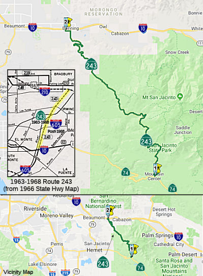
 In 1963, Route 243 was defined as "Route 10 to Route 210 near
Duarte.'
In 1963, Route 243 was defined as "Route 10 to Route 210 near
Duarte.'
In 1968, Chapter 282 deleted this routing and transferred it to I-605. According to the September 1965 CalTrans planning map, Route 243 was to be freeway between I-10 and I-210 along what is now I-605.
During December 1968. the Federal Highway Administration added the San
Gabriel River Freeway north of I-10 as chargeable Interstate. The
addition of I-605 as being chargeable north of I-10 was made due to the
provisions of the 1968 Federal Highway Aid Act.
(Source: Gribblenation Blog (Tom Fearer), "The original California State Route 243 on the San Gabriel River Freeway")
In 1970, Chapter 1473 redefined Route 243 as "Route 74 near Mountain
Center to Route 10 near Banning."
Construction of the Banning-Idyllwild Panoramic Highway began during 1904
and was completed as an oiled highway by September 1910. Banning-Idyllwild
Highway would become part of the National Forest Highway System in 1927.
The Idyllwild-Hemet portion of the Banning-Idyllwild Panoramic Highway was
repurposed as part of the Pines to Palms Highway, and was designated as
such in the 1930s. Around 1966, the route was designated Riverside County Sign Route R1
before being becoming Route 243 during 1970.
(Source: Gribblenation Blog (Tom Fearer), "California State Route 243", May 2022)
 Pre 1964 Signage History
The 1964-1968 incarnation of Route 243 was LRN 170. LRN 170 was defined
during 1933, and was signed as part of Sign Route 35 in 1934. The original
definition of LRN 170 was: "LRN 179 near Seal Springs via Santa Fe Springs
to LRN 26 near West Covina."
In December 1954, the entire 23-mile corridor of the San Gabriel River
Freeway/LRN 170 was adopted by the California Highway Commission.
The corridor was approved to become a chargeable Interstate on September
15, 1955; the original corridor of LRN 170 between LRN 179 and LRN 26
would be eventually assigned I-605. 1957 Legislative Chapter 36
extended the definition of LRN 170 south to US 101A/LRN 60 (future Route 1) near Seal Beach. 1959 Legislative Chapter 1062 extended the
definition of LRN 170 to US 66/LRN 9 in Duarte (future I-210).
Neither extension of LRN 170 was part of the original I-605.
(Source: Gribblenation Blog (Tom Fearer), "The original California State Route 243 on the San Gabriel River Freeway")
During the 1964 Renumbering, Sign Route 35 was repurposed over what was
Sign Route 5 in the Santa Cruz Mountains. The entirety of LRN 170
and the San Gabriel River Freeway was broken up into three designations:
I-605 was from "Route 405 to Route 10 near the San Gabriel River."
The segment S of I-405 to Route 1 became Route 240. The segment N of
I-10 to I-210 became Route 243.
(Source: Gribblenation Blog (Tom Fearer), "The original California State Route 243 on the San Gabriel River Freeway")
The post-1970 incarnation of Route 243 existed in 1963, but was not part of the state highway system. It was Banning-Idyllwild Road.
 Status
Winter 2018 Storm Damage (~ RIV 9.985 to RIV 16.937; Failed Culvert at RIV 15.6)
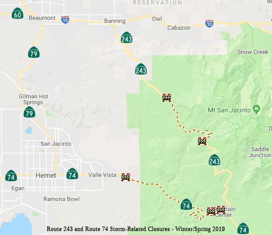 In December 2018, it was reported that Caltrans was closing a three-tenths-mile
section of Route 243, about one mile northwest of picturesque Lake Fulmor
(~ RIV 15.5), to replace an aging drain pipe under the road. With waves of
storms sweeping across Southern California, there is concern the pipe may
not be able to handle runoff and that water could spill over the highway
and damage it.
In December 2018, it was reported that Caltrans was closing a three-tenths-mile
section of Route 243, about one mile northwest of picturesque Lake Fulmor
(~ RIV 15.5), to replace an aging drain pipe under the road. With waves of
storms sweeping across Southern California, there is concern the pipe may
not be able to handle runoff and that water could spill over the highway
and damage it.
(Source: Press Enterprise, 12/6/2018)
In January 2019, the CTC received a report of the
following emergency allocation: $1,150,000 Riverside 08-Riv-243 15.6.
Route 243 Near Idyllwild, 1.1 miles north of Lake Fulmor Bridge. On
September 11, 2018, field investigation determined a misaligned culvert
had joint separation and caused pavement distress and embankment erosion.
This project will replace the 36 inch Reinforced Concrete Pipe (RCP),
restore embankment, and repair the distressed pavement.
(Source: January 2019 CTC Minutes Agenda Item 2.5f.(1) Item 8)
In January 2019, the CTC approved adding the following
project into the SHOPP: 08-Riv-243 15.6 PPNO 3012Y. Proj ID 0819000024. EA
1K350. Route 243 Near Idyllwild, 1.1 miles north of Lake Fulmor. Bridge.
Replace failed culvert. Total: $1,370,000.
(Source: January 2019 CTC Minutes, Agenda Item 2.1a(1) Item 7)
In February 2019, it was reported that an emergency
contract for $8 million was awarded to Ames Construction to make the
repairs to Route 243 and Route 74 near Lake Fulmor to repair roadway
damage from the Winter 2019 storms. In mid-February, it was noted that
there was a new collapse on Route 74, and Route 243 washed out about a
mile from where a waterfall destroyed the road the day before, north of
Lake Fulmor. The only way into Idyllwild is from Palm Desert along Route 74, known as the Palms to Pines Highway, Caltrans said. Even then, that
path is open only to residents and business owners/employees. According to
a Caltrans news release, a large hole formed underneath the road after
heavy rains eroded the soil. As the rain poured down, the hole made way
for a fast-flowing waterfall. The highway will be closed between I-10
Freeway and the city of Idyllwild for at least two months.
(Source: Press Enterprise, 2/15/2019; LATimes,
2/19/2019)
In March 2019, it was reported that it may be Summer
2019 before Route 74 and Route 243 completely reopen to the general public
due to the extensive repair work required to restore the corridors, both
of which were severely damaged during a mid-February storm event, Caltrans
announced. "There are over 25 locations on Route 243 with damage,
including two locations with complete road loss," according to a Caltrans
statement. "Route 74 has over 40 locations that will require repairs. At
this time, Caltrans is estimating at least four months before public
access or reopening of both highways can take place." The worst of the
damage was in the area of Lake Fulmor, between Pine Cove and Banning,
where Route 243 completely collapsed and disappeared amid torrential
downpours and mud flows on Feb . 14. Another segment of the two-lane,
30-mile corridor, which is the primary north-south artery through the
southern half of the San Bernardino National Forest, also gave way south
of Idyllwild. The entire highway is out of service between I-10 and
Idyllwild, while the southern half between Mountain Center and Idyllwild
is accessible to residents and business owners. A 15-mile segment of Route 74 is out of service because of the storm damage, which caused washouts
and sinkholes. A portion of the highway at the Strawberry Creek crossing,
roughly three miles west of Mountain Center, collapsed after it was
compromised by runoff. The highway is closed from Valle Vista, just east
of Hemet, to Mountain Center. As of March 28, 2019, it was reported that
Ames Construction is continuing the $8 million emergency repairs to
roadbeds, slopes, culverts and other items of work on both Route 74 and
Route 243, working twenty-four (24) hour shifts to rebuild the routes. It
was estimated that by May 2019, Caltrans will provide access to motorists
on Route 74 under escort for three hours in the morning (4 a.m. to 7 a.m.)
and three hours in the late evening (6 p.m. to 9 p.m.). In late April
2019, Caltrans expected to open Route 243 from Idyllwild to Lake Fulmor.
The contractor will continue work to prepare for full access to motorists
on Route 243 with flagging conditions in the coming months.
(Source: Palm Desert Patch, 3/12/2019; CaltransDistrict
8 Commuter Alert, 3/28/2019)
In April 2019, it was reported that a portion of Route 243 in Idyllwild was reopening on Mon 4/8/2019. Access from Idyllwild to
Lake Fulmor on Route 243 will now be allowed. Additionally, the public
will be able to access the Lake Fulmor Day-Use Area as well as Hall Decker
Rd.
(Source: Caltrans District 8 Commuter Alert 4/8/2019)
In May 2019, it was reported that additional May rains
that further damaged the already crumbling roadways shattered by heavy
rains on Feb. 14. Caltrans officials said work on Route 74 was delayed at
least two months and reconstruction on Route 243 has no time frame for
completion. Initial estimates indicated Route 74 would reopen by Memorial
Day and Route 243 perhaps by year's end.
(Source: Desert Sun, 5/30/2019)
In June 2019, the CTC approved the following amendment
to the SHOPP: Major Damage Restoration Item 20: 08-Riv-243 0.0/28.0 PPNO
3013N ProjID 0819000058. Route 243 Near Banning, from Route 74 to 0.3 mile
south of Wesley Street; also on Route 74 from Willowbrook Road to 0.1 mile
east of Devils Ladder Road (PM R47.0/70.0). Repair roadway washouts,
damaged pavement, embankment, guardrail, and culverts. PA&ED $200K;
PS&E $200K; R/W Sup $10K; Con Sup $1,200K; R/W Cap $200K; Const Cap
$7,950K; Total $9,760K.
(Source: June 2019 CTC Minutes, Agenda Item
2.1a.(1) MDR Item 20)
In June 2019, the CTC was informed of the following
emergency allocation: $32,650,000 for 08-Riv-243 0.0/28.0 PPNO 08-3013N.
ProjID 0819000058. Route 243 Near Banning, from Route 74 to 0.3 mile south
of Wesley Street; also on Route 74, from Willowbrook Road to 0.1 mile east
of Devils Ladder Road (PM R47.0/70.0). On February 14, 2019 intense
rainfall caused flooding, erosion, and undermining at various locations
along Route 243 and Route 74. This project will excavate and backfill
damaged roadway, remove debris, reconstruct slope embankment, and repair
guardrail and damaged drainage systems. After the receding of flood water
that then allowed assess to all damaged areas, supplemental funds became
necessary to address expanded damaged locations. This supplemental is the
same scope of work but is required to complete the project due to the
increased magnitude of the damaged roadway. R/W Cap. $200,000. Const.
$29,950,000 Const. Engr. $2,700,000.
(Source: June 2019 CTC Minutes Agenda Item 2.5f.(1)
Item 21)
In June 2019, it was reported that Caltrans has said
there’s no projection for when the heavily damaged Route 243 will
reopen, and it could stay shut until next year.
(Source: KTLA, 6/25/2019)
At the end of October 2019, it was reported that Route 243 has reopened. After the storms in February 2019, a section of a
mountain slope buckled near Lake Fulmor, leaving behind a gaping hole in
the roadway that serves as the main route in and out of the Idyllwild,
Mountain Center and Pine Cove mountain communities. More than $8 million
was allocated to fix both Route 243 and Route 74, which was also damaged
during the same storm, Caltrans said. Additionally, Route 243 was repaved
during the closure, with a $10 million paving project that had been
previously scheduled. Caltrans has also begun a $25 million project to
upgrade and restore culverts along the routes.
(Source: KTLA, 10/30/2019; CaltransDistrict
8 on Twitter)
 Naming
 Route 243 is named the "Esperanza Firefighters Memorial Highway".
The Esperanza Fire was a large, wind-driven, arson-caused wildfire that
started on October 21, 2006, in Esperanza and San Gorgonio Wash in
Riverside County near Cabazon, California, west of Palm Springs,
California. By October 29, 2006, it had burned over 41,173 acres (61
square miles) and was 85% contained. On October 30, 2006, the fire was
fully contained. Five firefighters from Forest Service Engine Company #57
were killed defending a vacant house locally known as the "Octagon" that
was ultimately destroyed by the fire: While unselfishly serving their
community with great honor and dedication on October 26, 2006, these five
firefighters were overrun by the flames of the Esperanza Fire when the
winds shifted and blew the fire towards them. Mclean and McKay died next
to their fire engine without having time to enter it. Najera's body was
found to the west of the structures they were trying to protect. The
surviving two firefighters were transferred to Arrowhead Regional Medical
Center where Loutzenhiser succumbed to his injuries shortly after
arriving. Cerda died at 5:08 p.m. PST on October 31, 2006 in Arrowhead
Regional Medical Center from his injuries. The fire destroyed 34
houses and 20 outbuildings, as well as damaging the pavement of Route 243.
The damage the fire caused is estimated at more than $9 million, and was
the worst wildfire caused by arson since 1994. In June 2009, Raymond Lee
Oyler was sentenced to death for starting the fire. Named by Assembly
Concurrent Resolution (ACR) 4, Resolution Chapter 99, on 7/12/2007.
Route 243 is named the "Esperanza Firefighters Memorial Highway".
The Esperanza Fire was a large, wind-driven, arson-caused wildfire that
started on October 21, 2006, in Esperanza and San Gorgonio Wash in
Riverside County near Cabazon, California, west of Palm Springs,
California. By October 29, 2006, it had burned over 41,173 acres (61
square miles) and was 85% contained. On October 30, 2006, the fire was
fully contained. Five firefighters from Forest Service Engine Company #57
were killed defending a vacant house locally known as the "Octagon" that
was ultimately destroyed by the fire: While unselfishly serving their
community with great honor and dedication on October 26, 2006, these five
firefighters were overrun by the flames of the Esperanza Fire when the
winds shifted and blew the fire towards them. Mclean and McKay died next
to their fire engine without having time to enter it. Najera's body was
found to the west of the structures they were trying to protect. The
surviving two firefighters were transferred to Arrowhead Regional Medical
Center where Loutzenhiser succumbed to his injuries shortly after
arriving. Cerda died at 5:08 p.m. PST on October 31, 2006 in Arrowhead
Regional Medical Center from his injuries. The fire destroyed 34
houses and 20 outbuildings, as well as damaging the pavement of Route 243.
The damage the fire caused is estimated at more than $9 million, and was
the worst wildfire caused by arson since 1994. In June 2009, Raymond Lee
Oyler was sentenced to death for starting the fire. Named by Assembly
Concurrent Resolution (ACR) 4, Resolution Chapter 99, on 7/12/2007.
(Image source: Press Enterprise; Press Enterprise; Firefighting News; #EsperanzaFire on Twitter; Additional information: Wikipedia)
 Scenic Route
[SHC 263.1] Entire route.
 Interregional Route
[SHC 164.19] Entire route.
 Other WWW Links
 Statistics
Overall statistics for Route 243:
 Pre-1964 Legislative Route
In 1959, Chapter 1062 defined LRN 243 as “[LRN 89] south of Kelseyville to [LRN 49] near Lower Lake”. This route runs from Route 29 S of Kelseyville to Route 53 near Lower Lake. This is part of present-day Route 29.
© 1996-2020 Daniel P. Faigin.
Maintained by: Daniel P. Faigin
<webmaster@cahighways.org>.
 From Route
  Route 242
 Route 244