
 California Highways:
Click here for a key to the symbols used. An explanation of acronyms may be found at the bottom of the page.
 Routing
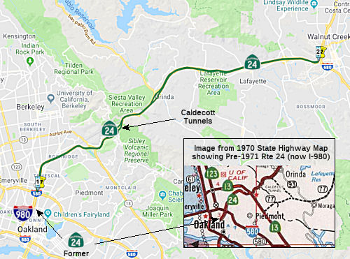 From Route 580 in Oakland to Route 680 in Walnut Creek.
 Post 1964 Signage History
▸In 1963, there was an additional segment before this one: "Route 17 near Castro Street in Oakland to Route 580". In 1981, Chapter 292 deleted this segment, moving that routing to I-980. That segment was originally LRN 226, defined in 1959.
▸This segment (former (b), now (a)) remains as defined in 1963.
In 1966, construction was completed on Route 24 (Grove-Shafter Freeway)
between 0.4 mi W of Route 13 in Oakland and the Caldecott Tunnel in
Berkeley (1.3 mi).
(Source: CHPW Nov/Dec 1966)
 The Gateway Boulevard viaduct on Route 24 west of Orinda may have been constructed for
the intersection of a future freeway, according to one account that I
read. I have not yet confirmed this. The viaduct is located near where
Route 93 was planned to intersect Route 24. The exit from Route 24 appears
to have been renamed, and is now Wilder Road.
The Gateway Boulevard viaduct on Route 24 west of Orinda may have been constructed for
the intersection of a future freeway, according to one account that I
read. I have not yet confirmed this. The viaduct is located near where
Route 93 was planned to intersect Route 24. The exit from Route 24 appears
to have been renamed, and is now Wilder Road.
(Source: Mail from Jason A. Bezis, 7/2/2002; Image Source: Mark Harrigan: Reel: The Lost Highways of Contra Costa County, Google Street View, 9/2/2026)
 Pre 1964 Signage History
 In 1931, a routing from a proposed Oakland tunnel to Walnut Creek was proposed. This appears to correspond to the eventual Route 24,
however, this segment was not included in the original signage of Sign
Route 24 defined in 1934.
 California Highways and Public
Works, in April 1931, reported that Joint Highway District Number 13,
composed of Alameda and Contra Costa counties, had organized for
construction of a public highway and tunnel to supersede the pre-1931
narrow, crooked and inadequate 'Tunnel road in Alameda County and to
improve the Contra Costa County road from the tunnel to the town of Walnut
Creek. The state proposed for inclusion as a state highway that portion of
the route in Contra Costa County between. the tunnel and Walnut Creek, a
distance of 9.6 miles. Based on the volume and class of traffic on the
pre-1931 tunnel road and on the other highways leading into Oakland (one
from Livermore via Hayward, the other from Martinez through Crockett), and
estimating the effect of better facilities in the Walnut Creek area, the
conservative 12 hour traffic was anticipated for 1940 as equivalent to a
24 hour traffic of 17K vehicles on Sundays and 10K on weekdays. The state
felt this route qualified for state inclusion based on volume, importance,
and character of 1931 and future traffic.
California Highways and Public
Works, in April 1931, reported that Joint Highway District Number 13,
composed of Alameda and Contra Costa counties, had organized for
construction of a public highway and tunnel to supersede the pre-1931
narrow, crooked and inadequate 'Tunnel road in Alameda County and to
improve the Contra Costa County road from the tunnel to the town of Walnut
Creek. The state proposed for inclusion as a state highway that portion of
the route in Contra Costa County between. the tunnel and Walnut Creek, a
distance of 9.6 miles. Based on the volume and class of traffic on the
pre-1931 tunnel road and on the other highways leading into Oakland (one
from Livermore via Hayward, the other from Martinez through Crockett), and
estimating the effect of better facilities in the Walnut Creek area, the
conservative 12 hour traffic was anticipated for 1940 as equivalent to a
24 hour traffic of 17K vehicles on Sundays and 10K on weekdays. The state
felt this route qualified for state inclusion based on volume, importance,
and character of 1931 and future traffic.
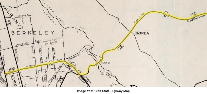
In October 1935, it was reported that the Sign Route 24 signage had been extended south from Sacramento to Oakland, via Isleton, Antioch, and Walnut Creek. This may have been related to the opening of the Broadway Tunnels. Note that portions of what was Sign Route 24 are present-day Route 242 and Route 4.
Sign Route 24 started at US 40 (now I-80) at the Oakland City Hall at 14th
and San Pablo. It then ran along Broadway to College, then along College
to Claremont Ave. Along Claremont, it entered Berkeley. It jogged briefly
along Ashby Avenue (present-day Route 13, LRN 206, defined in 1935) to
Tunnel Road, continuing into Contra Costa County. The route was LRN 75.
(Source: Old Oakland Maps, 1936)
Sign Route 24 then ran E to Walnut Creek (along present-day Route 24); this was LRN 75. It was then likely cosigned with Sign Route 21 until the Sign Route 21/Sign Route 24 junction (this segment of Sign Route 21 was also LRN 75). This was all defined in the 1931-1933 time, but was not signed as Sign Route 24 in 1934.
The original routing for Route 24 included what is now Route 13 (renumbered in 1964) between the present Route 13/Route 24 interchange in Oakland and I-80. That segment was LRN 206, and ran along Ashby Avenue. It was added to the state highway system in 1935. However, the actual highway did not exist until the Broadway (later called "Caldecott") Tunnel opened in 1937.
The Ashby routing was part of the larger Bay Bridge project which included construction of the Eastshore Highway with which Ashby connected. On the other side of the hills, Route 24 was routed on Mount Diablo Boulevard.
Caldecott Tunnels and Predecessors
The original routing between Oakland and Lafayette over
the Berkeley Hills of Alameda County followed a steep ascent via what is
now Telegraph Avenue and Claremont Avenue. Upon cresting the Berkley Hills
this road would have followed what is now Fish Ranch Road in Contra Costa
County. The first known concept for a tunnel through the Berkeley Hills
emerged in 1860 but was rejected by the populace in Alameda County and
Contra Costa County. Another concept emerged in 1871 as an extension of
Broadway via a vaguely described path which would emerge somewhere near
San Pablo Creek in Contra Costa County. This 1871 concept would eventually
emerge as the route of a choice for a tunnel and would sporadically be
under construction during the following decades. Eventually the tunnel
construction was taken up by the Merchants Exchange of Oakland which
procured the funding and permits to complete construction.
(Source: Gribblenation Blog (Tom Fearer), “Former California State Route 24 through the Kennedy Tunnel and Old Tunnel Road”, January 2021)
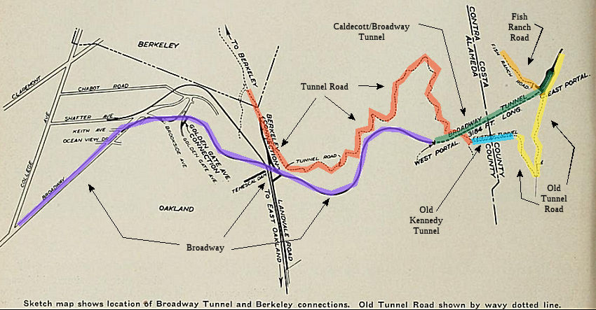 The resulting "Inter County Tunnel" was opened November
4th, 1903, and was later renamed as the "Kennedy Tunnel". It was a
single-lane, timber-supported, 1000' structure that served as a conduit
until 1937, when the first Caldecott bores were completed and dedicated.
The tunnel closed in the 1940s. Lafayette residents protested the tunnel,
predicting that it would increase competition for land and price them out
of the market. But private and county money eventually financed a tunnel.
The Kennedy Tunnel had a four-foot elbow in the middle; diggers had
miscalculated the meet-up. The tunnel was also called the the Broadway
Tunnel (although that name was also used for the Caldecott, at one time).
The western entrance was near Tunnel Road and Skyline Boulevard. The
eastern entrance is at the end of Old Tunnel Road. At the east entrance, a
residence owned by the East Bay Regional Park District stands on the
former site of the Canary Cottage cafe. The original tunnel has been
abandoned and the ends sealed.
The resulting "Inter County Tunnel" was opened November
4th, 1903, and was later renamed as the "Kennedy Tunnel". It was a
single-lane, timber-supported, 1000' structure that served as a conduit
until 1937, when the first Caldecott bores were completed and dedicated.
The tunnel closed in the 1940s. Lafayette residents protested the tunnel,
predicting that it would increase competition for land and price them out
of the market. But private and county money eventually financed a tunnel.
The Kennedy Tunnel had a four-foot elbow in the middle; diggers had
miscalculated the meet-up. The tunnel was also called the the Broadway
Tunnel (although that name was also used for the Caldecott, at one time).
The western entrance was near Tunnel Road and Skyline Boulevard. The
eastern entrance is at the end of Old Tunnel Road. At the east entrance, a
residence owned by the East Bay Regional Park District stands on the
former site of the Canary Cottage cafe. The original tunnel has been
abandoned and the ends sealed.
(Image source: December 1937 CHPW)
Broadway was chosen for LRN 75 (Route 24) over versus
Ashby Avenue (LRN 206 / Route 13) as Broadway, at the time, connected
directly with Tunnel Road whereas Ashby Avenue did not yet connect.
(Source: Gribblenation Blog (Tom Fearer), “Former California State Route 24 through the Kennedy Tunnel and Old Tunnel Road”, January 2021)
In 1937, the Caldecott Tunnels (called the Broadway Low-Level Tunnels) opened, a twin-bore tunnel designed to replace the dark, dank, single-bore Kennedy Tunnel 300 feet above it. At that time, some 30,000 cars were passing through Kennedy every week. The twin tunnels, each 3000' feet, were concrete lined, lighted, and had forced air ventilation. Note that as the two tunnels were curved at the end and joined one another at a single portal building at each end, there was a belief that there was just a single tunnel with a thin concrete supporting wall. In reality, the roadways are 150' apart except at the two ends. Each of the tunnels has a 22' wide roadway and a with of 26' 8" between the sidewalls. Each bore carried one direction of traffic.
Development in Contra Costa boomed and a third bore opened in 1964, outfitted with a system of tubes that popped out of the pavement and allowed workers to change directions of the middle bore to handle traffic, which generally flowed west in the morning and east in the evening. Modern standards required that the highways at each end of the tunnels be widened and straightened and that the third bore be made wider than the first two. As the third tunnel was to be considerably larger than the two older tunnels, it was not possible to adapt the original plans to the new location. The third tunnel has a 28 foot wide roadway and is 34 feet 6 inches wide between the sidewalk. The vertical clearance is 17 feet above the pavement, compared with the 14 feet 10 inches in the two older bores. In addition to the larger size of the tunnel itself, there are numerous other features which are new or improved. The entire length of the roadway is illuminated by a continuous line of fluorescent lights on each side of the ceiling. Extra lights are placed for a distance of 300 feet at each end so that there is a gradual transition in the daytime in order to allow drivers' eyes to adjust to the change from the bright sunlight outside and the artificial light in the center of the tunnel. Emergency power facilities have also been installed for use in the event that there is a power loss from the serving utilities. A new transverse system of ventilation is being used. Fresh air is taken in at the westerly portal building and carried along a duct above the roadway. It is discharged into the roadway section through openings at one side of the ceiling. The fresh air mixes with exhaust fumes from the vehicles, and is drawn out through exhaust ports on the opposite side of the ceiling, then carried to the westerly portal building and discharged straight up into the atmosphere. The two fresh air and two exhaust blowers have a capacity of a half-million cubic feet of air per minute. On October 6, 1964, dignitaries from throughout the area assembled to dedicate Tunnel III to the name and further honor of Thomas E. Caldecott.
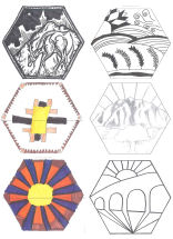 Adorning the original Caldecott
Tunnel bores are medallions that were designed by Henry Meyers, the
official Alameda County architect in the 1930s. One depicts people facing
each other to symbolize how the tunnel joins the residents of Contra Costa
and Alameda counties; another shows a car headlight exiting a tunnel.
Meyers may have had a lot of help from draftsman George Klinkhardt in
designing the tunnel exterior and medallions, a Caltrans report suggests.
In fact, Klinkhardt may have designed the entire tunnel exterior, the
reports says. Meyers, who grew up in Livermore and whose Alameda home has
been turned into a museum, designed more than 200 buildings, including
Highland Hospital in Oakland, the Posey Tube in Alameda and 10 veterans
memorial buildings, including the ones in Livermore and Pleasanton. In
2012, Caltrans held a student design competition to design medallions to
adorn the new 4th bore. The competition will be limited to students from
Contra Costa and Alameda counties. The six new hexagon-shaped medallions
-- each about 36 inches high -- will be public art for the ages.
Adorning the original Caldecott
Tunnel bores are medallions that were designed by Henry Meyers, the
official Alameda County architect in the 1930s. One depicts people facing
each other to symbolize how the tunnel joins the residents of Contra Costa
and Alameda counties; another shows a car headlight exiting a tunnel.
Meyers may have had a lot of help from draftsman George Klinkhardt in
designing the tunnel exterior and medallions, a Caltrans report suggests.
In fact, Klinkhardt may have designed the entire tunnel exterior, the
reports says. Meyers, who grew up in Livermore and whose Alameda home has
been turned into a museum, designed more than 200 buildings, including
Highland Hospital in Oakland, the Posey Tube in Alameda and 10 veterans
memorial buildings, including the ones in Livermore and Pleasanton. In
2012, Caltrans held a student design competition to design medallions to
adorn the new 4th bore. The competition will be limited to students from
Contra Costa and Alameda counties. The six new hexagon-shaped medallions
-- each about 36 inches high -- will be public art for the ages.
In July 2012, the updated artwork was chosen. Specifically, six students’ winning images of Mount Diablo, rugged foothills, and the sun will be built into the exterior of the Caldecott Tunnel Fourth Bore.
 Status
This route is constructed as a freeway.
Caldecott Tunnel Rehabilitation (04-Ala-24, PM R5.80/R6.24; 04-Cc-24, PM R0.00/R0.60)
The 2022 SHOPP included the following new project:
04-CC-24 R0.01. PPNO 0480B; ProjID 0414000011; EA 0J540. Route 24 In
Orinda, at the Caldecott Tunnel № 28-0015R, 28-0015, and 28-0015L.
Rehabilitate Caldecott Tunnel Bores 1, 2, and 3. Total Project Cost:
$69,487K. Begin Con: 10/1/2026.
(Source: “2022 State Highway Operation
And Protection Program, Fiscal Years 2022-23 through 2025-26”,
March 17, 2022)
In August 2025, the CTC approved for future
consideration of funding 04-Ala-24, PM R5.80/R6.24; 04-Cc-24, PM
R0.00/R0.60. Caldecott Tunnel Bores 1, 2, and 3 Rehabilitation and
Ventilation Upgrade Project. Rehabilitate Bores 1, 2, and 3 of the
Caldecott Tunnel at PM R5.80/R6.24 and R0.00/R0.60 on Route 24 in Alameda
and Contra Costa Counties. This project will preserve the structural
integrity of the tunnel and extend its service life. (PPNO 04-0480B) The
project will install a new fire suppression and ventilation system. The
project is currently programmed in the 2024 SHOPP. The total programmed
amount which includes Right of Way (Support and Capital), and Construction
(Support and Capital) is $242,608,000. Construction will begin in 2026-27.
The scope, as described for the preferred alternative, is consistent with
the project scope as programmed by the Commission in the 2024 SHOPP. The
project will result in less than significant impacts to the environment
after mitigation. Project implementation may have significant impacts on
cultural resources, specifically, the bores as historical resources.
However, mitigation measures will reduce any potential impacts on the
environment to less than significant. These measures include, but are not
limited to, preparation of a Built Environment Treatment Plan, maintaining
Historic American Engineering Record documentation, developing webinar and
virtual tour materials and conducting a limited number of in-person tours
of Bores 1 and 2, and installation of interpretive panels that discuss the
history of the tunnels. As a result, an MND was completed for this
project.
(Source: August 2025 CTC Agenda, Agenda Item 2.2c.(1) #2)
In August 2025, the CTC approved the following
pre-construction phase allocation for a 2024 SHOPP SB1 project:
$14,584,000. 04-CC-24 R0.01 04-Ala-24 R5.8/R6.2.
PPNO 04-0480B; ProjID 0414000011; EA 0J540. Route 24 In Orinda, at the
Caldecott Tunnel № 28-0015R, 28-0015, and 28-0015L.
Rehabilitate Caldecott Tunnel Bores 1, 2, and 3.; also in
Contra Costa at Caldecott Tunnel (R0.0/R0.6). Rehabilitate and upgrade
ventilation system of Caldecott Tunnel Bores 1, 2, and 3. (G13
Contingency) Concurrent consideration of funding under Resolution E-25-48;
August 2025. Pre-Construction Phase Allocation: Budgeted (Actual,
if different): PS&E $14,400,000; RW Sup $184,000.
(Source: August 2025 CTC Agenda, Agenda Item 2.5b.(2b) #3)
In June 2026, the CTC amended the following project
that currently in the 2026 SHOPP: 04-Ala-24 R5.85.7/R6.2.
PPNO 04-0480B; ProjID 0414000011; EA 0J540. In Orinda, at the Caldecott
Tunnel № 28-0015R, 28 -0015, and 28-0015L; also in Contra Costa at
Caldecott Tunnel (R0.0/R0.60.7). Rehabilitate and
upgrade ventilation system of Caldecott Tunnel Bores 1, 2, and 3. This
is a Construction Manager/General Contractor (CMGC) project. Note:
Increase in construction capital to add underdrain system upgrades in
Bores 1 to 3. Split electronic communication integration work into
project EA 0J541/PPNO 04-3924W from parent project EA 0J540/PPNO 04
0480B. Adjust postmiles at starting and ending project limits for
traffic switching and traffic control work during extended tunnel closure.
Update description to show CMGC delivery method. Allocation changes ($
× $1000): PA&ED $6,269; PS&E $14,400; R/W Sup $184; Con Sup
$20,850; R/W Cap $253; Const Cap $200,652 $203,402;
TOTAL $242,608 $245,358.
(Source: June 2026 CTC Agenda, Agenda Item 2.1a.(1d) #13)
In August 2026, the CTC approved the following
allocation for SHOPP construction project phases (Con Sup, R/W Cap, Const
Cap): $266,730,000. 04-Ala-24 R5.7/R6.2. PPNO 04-0480B; ProjID 0414000011;
EA 0J540. Route 24 In Orinda, at the Caldecott Tunnel № 28-0015R,
28-0015, and 28-0015L; also in Contra Costa at Caldecott Tunnel
(R0.0/R0.7). Rehabilitate and upgrade ventilation system of Caldecott
Tunnel Bores 1, 2, and 3. This is a Construction Manager/General
Contractor (CMGC) project. CEQA - MND, 06/26/2025; Re-validation
05/06/2026. NEPA - FONSI, 06/26/2025; Re-validation 05/06/2026. Future
consideration of funding approved under Resolution E-25-48; August 2025.
SB1 Baseline Agreement approval under Resolution SHOPP-P-2526-03B;
December 2025. Pre-Construction Expenditures: Budgeted (Expended):
PA&ED $6,269,000 ($6,259,755); PS&E $14,400,000 ($12,623,146);
RW Sup $184,000 ($10,402). Construction Phase Allocation:
Budgeted (Actual, if different): Con Sup $20,850,000;
Const Cap $203,402,000 .
(Source: August 2026 CTC Agenda, Agenda Item 2.5b.(1) #18)
In September 2026, it was reported that the Caldecott
Tunnels, a major thoroughfare between Contra Costa and Alameda counties,
is poised for a major renovation backed by $267 million in federal and
state funding. The project will be the most extensive investment in the
tunnel since the addition of the fourth bore, completed in 2013, which
exposed just how much of an upgrade the other three tunnels needed. The
new project will include an improved ventilation system, better lighting
and upgraded drainage for three of the oldest routes in the four-tunnel
system, which moves drivers along Route 24 through the Berkeley and
Oakland hills. Caltrans plans to replace fans in the three oldest tunnels
with jet fans that are better equipped to manage smoke in case of a fire
in addition to providing better airflow during day-to-day operation.
Upgrading the drainage system, repairing cracks, rust and water damage and
improving the electrical and lighting systems are also meant to preserve
the structural integrity of the tunnels. Construction is expected to take
three years, beginning in November, according to the project’s
environmental report. To mitigate traffic impacts, at least two bores, one
going either direction, will remain open at a time, and some work will
occur in the evenings and over weekends.
(Source: Mercury News, 9/3/2026 · Archived)
4th Bore - Caldecott Tunnel (~ ALA R5.858 to CC R0.416)
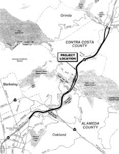 In September 2000, the California
Transportation Commission considered (TCRP Project #15) a $15 million
allocation for phase one of construction of a fourth bore tunnel with
additional lanes for the Caldecott Tunnel (~ ALA R5.858 to CC R0.416). The
total estimated cost is $185 million. This project was requested by the
Metropolitan Transportation Commission. Bore 3, constructed in the early
1960's (long after bores 1 and 2) was actually constructed with the fourth
bore being kept in mind. As evidenced by the tunnel, stub lanes (on both
ends of the tunnel) do actually indicate a 4th bore was in
mind, as small strips of pavement (wide enough for 2 lanes) spur from the
existing highway before fading off into the bushes and trees before
entering the tunnel. This is currently planned to complete construction in
late 2012. Funding was extended for this in September 2005.
In September 2000, the California
Transportation Commission considered (TCRP Project #15) a $15 million
allocation for phase one of construction of a fourth bore tunnel with
additional lanes for the Caldecott Tunnel (~ ALA R5.858 to CC R0.416). The
total estimated cost is $185 million. This project was requested by the
Metropolitan Transportation Commission. Bore 3, constructed in the early
1960's (long after bores 1 and 2) was actually constructed with the fourth
bore being kept in mind. As evidenced by the tunnel, stub lanes (on both
ends of the tunnel) do actually indicate a 4th bore was in
mind, as small strips of pavement (wide enough for 2 lanes) spur from the
existing highway before fading off into the bushes and trees before
entering the tunnel. This is currently planned to complete construction in
late 2012. Funding was extended for this in September 2005.
The SAFETEA-LU act, enacted in August 2005 as the reauthorization of TEA-21, provided the following expenditures on or near this route:
In February 2006, the CTC noted that the goal of TCRP Project #15 is to improve the movement of people and goods along Route 24 via the Caldecott Tunnels, to improve travel time and therefore reduce delays, and enhance safety of the traveling public and Department maintenance workers. When the environmental process started, seven alternatives were under consideration. Based on several screening criteria, four alternatives were dropped. The elimination of the four alternatives reduced the cost and the Department and the Contra Costa Transportation Authority (CCTA) have identified $5,000,000 of available TCRP funds for other work. In February 2006, the Department and CCTA request that the funds be redistributed to Plans, Specifications, and Estimates. The Draft Environmental Document is being finalized and will be ready for circulation in July 2006. The alternatives being considered are:
The Final EIR was received in December 2007, and the CTC indicated construction is estimated to begin in Fiscal Year 2009-10. The total estimated project cost, capital and support, is $420,000,000. The project is funded from $175,000,000 local funds, $20,000,000 Traffic Congestion Relief Program funds, $1,000,000 Federal Demonstration funds, $18,000,000 in Regional Improvement Program funds, $31,000,000 Interregional Improvement Program funds, and $175,000,000 Corridor Mobility Improvement Account funds. The funding sources were adjusted in June 2008.
In January 2009, Caltrans removed one of the last obstacles preventing it from adding a fourth bore to the Caldecott Tunnel by settling a lawsuit with Oakland residents concerned about the impacts of building the new tunnel. The settlement to the suit by the Caldecott Fourth Bore Coalition calls for Caltrans to:
The settlement was crafted between attorneys for the coalition and Caltrans with pressure from state legislative leaders and Gov. Arnold Schwarzenegger, who wanted to see the fourth bore built as part of his state economic stimulus strategy. He had sought to have the project exempted from the environmental review process, which would have nullified the suit, but that undoubtedly entangled the project in other legal challenges. However, the project may still get caught up in the 2008/2009 Budget mess. The $420 million Caldecott Tunnel project depends on $194.5 million from the transportation infrastructure bonds voters approved in 2006. Plans to hire a contractor to start digging the long-awaited fourth bore this summer were halted Jan. 14 2009, when the California Transportation Commission froze funding for the Caldecott Tunnel and 26 other projects that had been scheduled to receive $293.5 million in state funding. If the governor and the Legislature settle the budget crisis by early February, the fourth bore could receive funding from the transportation commission on Feb. 18 and Caltrans could start the process of hiring a contractor by March 1 - just two to four weeks behind schedule.
At the January 2009 meeting, the CTC deferred to February (and in February, deferred it to March... and in March, to April) discussion about reorganization of this project. The intent is to split the original project into four segments, as follows:
The basic plans for the project are:
In April 2009, the CTC approved funding this project (as a loan against future bonds) from 2009 Stimulus funds. It was advertised for construction in May 2009.
In late January 2010, politicians and transportation
officials gathered in an enclosed and heated tent in Orinda, not far from
the tunnel, to celebrate the official groundbreaking for the $420 million
fourth bore. After an hour and a half of speeches, they grabbed
gold-painted shovels and dug from a pile of dirt trucked in for the
ceremony. Actual construction was already under way with contractors
clearing brush and preparing to erect retaining walls on both sides of the
tunnel and a sound wall on the west end. In June 2010, workers expect to
begin digging the new tunnel from both ends. Tunneling crews will dig the
new hole in the Oakland hills in segments, first digging out the top of
the tunnel, then building the tunnel gradually by excavating a segment and
bolstering it with braces and sprayed concrete. They will also dig seven
cross-passages to the third bore - to provide emergency exits. The
completed bore will be 41 feet, 3 inches wide and 3,389 feet long.
Caltrans officials expect the project to create about 5,000 jobs during
the four years of construction. Nearly half of the money to pay for the
project is coming from federal stimulus funds. John Porcari, deputy
secretary of the U.S. Department of Transportation, said the fourth bore
is the largest recipient of stimulus funds for infrastructure in the
nation.
(Source: "Work begins on Caldecott Tunnel's 4th bore", San Francisco Chronicle, 1/23/2010)
Before the actual tunnel construction starts in July
2010, there has been significant preparatory work. Since January 2010,
construction crews have been busy building retaining walls to keep the
hills from collapsing onto Route 24. To build the retaining walls, crews
are boring holes about 2 1/2 feet across, 8 feet apart and 36 feet to 97
feet deep. The bottoms of the holes are filled with concrete, then steel
I-beams are dropped in. When all the beams are in place, the dirt in front
of them will be removed and wooden planks will be inserted between the
beams to hold back the hillside. Eventually they'll be covered in
concrete. The crews are also constructing and portal walls that will form
the eastern and western entrances to the new two-lane fourth bore. Just
north of the existing westbound tunnel, workers are preparing the concrete
and steel faces through which the digging of the fourth bore will
commence. The face is a series of interlocking columns formed by boring
holes, filling them with concrete, then boring new holes in between, and
filling them with concrete. The walls are then tied together and
strengthened with steel, creating a strong surface to dig through. Walls
on each side of the face are built by covering the soil with concrete then
inserting long, thick steel reinforcement rods into the earth. They're
grouted in place and act like long, strong nails. Workers have also
constructed a $3.5 million charcoal gray temporary sound wall between the
freeway and the apartments and condos on Caldecott Lane, just west of the
tunnel. This wall was constructed by putting I-beams in the ground,
putting huge wooden planks between them, then fastening 2-inch-thick
noise-absorbent plastic pads on both sides. The walls sport slanted tops
pointed toward the freeway. The idea is to trap the noise, light and dust
generated during construction when trucks use the narrow strip between the
freeway and the wall as a staging ground with a concrete plant,
water-treatment facility and dumping area for soils excavated from the
Oakland hills. Additionally, trees have been removed from the hillsides, a
traffic signal is being installed on Upper Broadway, and three electrical
substations are under construction.
(Source: "Caldecott Tunnel fourth bore under construction", San Francisco Chronicle, 5/21/2010)
In his 2006 Strategic Growth Plan, Governor Schwartzenegger proposed completing the Caldecott Tunnel Corridor. In 2007, the CTC recommended using $175M from the Corridor Mobility Improvement Account (CMIA) for the 4th bore.
In July 2010, it was reported that The $420 million excavation of a fourth bore of the Caldecott Tunnel between Orinda and Oakland has opened a door for paleontologists to search for fossils expected to give clues to old life-forms and climate change in the Bay Area. Private paleontologists hired by Caltrans already have found a tooth — likely a remnant of a camel — and dozens of remains of fish scales, plants and other bone bits in dirt and rock dug up, shoved around and shored up in early construction work outside the new bore site. One area considered prime for fossil finds is the Orinda Formation, a jumble of fractured layers of old stream beds and flood plains. The silt and sediment there is ideal for covering up and preserving fossils from creatures that roamed the East Bay 9 million to 10 million years ago in the Miocene period. This is the first time that Caltrans has called in paleontologists to a Bay Area freeway project at its beginning to monitor for fossils. Caltrans said it is paying about $35,000 a month for the paleontological work. The duration of the collection will be shaped by how long the crews keep finding fossils.
In March 2011, it was noted that, after a year of construction, construction crews have dug out more than 900 feet -- or 27 percent -- of the 3,389-foot-long Caldecott Tunnel fourth bore, a project now estimated to cost $391 million after favorable construction bids lowered the cost from $420 million. The 21,665 cubic meters of earth and rock excavated from the Caldecott fourth bore so far would cover a football field 16 feet deep. When the project is finished, the excavated earth would cover a football field 134 feet deep.
In September 2011, the New York Times reported on this construction. It noted that the project was projected to create 4,500 jobs. The work in the tunnel is more dangerous than work in the average tunnel. Safety regulators declared it “gassy” from the start because of the naturally occurring methane gas in the guts of the Berkeley Hills. Anything that could spark an explosion, from cellphones to lighters, is banned from the inside of the tunnel. Because of sections of precariously weak rock, miners must use what is called the New Austrian Tunneling Method, meaning that crews dig just short distances before taking measures to reinforce the tunnel. The digging machine, called a roadheader, is a 130-ton instrument that looks like a metal brontosaurus with a spiked metal rotating head for grinding rock. It is followed by a remote-controlled robot on wheels that sprays a special quick-drying concrete over the newly bored section. With another machine, the miners then drive long steel dowels into the tunnel walls to reinforce them before proceeding. Once the boring is completed, it will take two more years to scoop out the bottom portion, install ventilation, lighting and communication systems, and otherwise transform the rough-hewn hole through the hills into a subterranean stretch of freeway. By the end of 2013, the tunnel be able to accommodate four lanes of traffic in each direction. It will eliminate the need for Caltrans workers to engage in an often futile game of trying to minimize backups by switching the direction of traffic through the center bore at least twice daily, often more frequently.
In November 2011, it was reported that construction of the fourth bore broke through the Orinda hillside, thus connecting the two sections of the tunnel being dug. In January 2012, it was reported that state safety regulators have ruled the fourth bore project is no longer classified as a "gassy" tunnel, where methane and other gases could trigger explosions or fires.
In March 2012, it was reported that a competition was being held to design adornments for the 4th bore. Caltrans announced in late March 2012 the opening of the unusual competition to design six, 36-inch tall architectural medallions that will be cast out of concrete above the entrances to the Caldecott Tunnel fourth bore on Route 24. May 7 2012 was the deadline to submit original art deco drawings, which Caltrans plans to use in designing molds for pouring concrete to form the decorative shapes. The competition was limited to students from kindergarten through high school in schools in Contra Costa and Alameda counties. This is the first student-only architectural design competition Caltrans has used in the Bay Area. Caltrans picked "classic art deco" as the theme after the art style was strongly favored in an agency online poll on six different themes, and was the theme used on the other bores.
In April 2012, it was reported that excavation was taking longer than expected, owing to tough digging conditions. In Fall 2011, a crew of miners and their brontosaurus-like digging machine encountered unexpectedly difficult conditions — including harder rock formations and, in some places, water.
In August 2012, it was reported that the 4th bore was
completed. This bore contained safety features developed as a result of
the crash of a drunk driver inside the Caldecott Tunnel on April 7, 1982.
The crash touched off a chain reaction that turned the third bore into a
2,000-degree tomb and killed seven people. There were no emergency
passages, and the narrow tunnel had no shoulder. There were no traffic
lights, emergency gates or message signs to warn motorists of the fireball
inside, caused when a gasoline tanker burst into flames. Utilizing lessons
leared from this accident, new safety features for the third and fourth
bores include traffic lights and a traffic gate that swings down in
emergencies. The third and fourth bores also will be the first to have an
extensive network of electronic message signs and traffic signals inside;
and unlike the original two bores, the third and fourth will be connected
by seven lighted, 12-foot-wide escape passages. The escape passages are
air pressurized to keep smoke and toxic gases away from fleeing travelers.
Additionally, only the fourth bore has a shoulder, a 10-foot wide swath to
stash damaged vehicles or for fire trucks, ambulances or law enforcement
to access accidents. The Caldecott Tunnel also is safer than it was in
1982 because of a ban on trucking gasoline and other flammable liquids or
poison gases through the tunnel, except between 3 and 5 a.m. Even when the
new bore opens, some safety features will be hidden, such as water lines.
Some will be too small to see, like heat sensors. Most obvious will be 19
ceiling-mounted fans, all capable of churning up 20 mph breezes to sweep
away smoke and gases. The fans are more powerful than those in the other
bores. One new safety feature common to all four bores is a radio override
system that allows tunnel operators to broadcast emergency messages on car
radios, regardless of the station to which they are tuned.
(Source: Contra Costa Times, 10/31/13)
In November 16, 2013, the new fourth bore opened.
 Naming
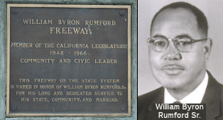 Route 24 from I-580 to the Caldecott
Tunnel (~ALA R1.914 to ALA R5.837) is named the "William Byron Rumford
Freeway". Byron Rumford was a State legislator. Named by Assembly
Concurrent Resolution 137, Chapter 92 in 1980. The dedication plaque
reads: William Byron Rumford Freeway, Member of the California Legislature
1948-1966, Community and Civic Leader. This freeway on the state system is
named in honor of William Byron Rumford Sr. for his long and dedicated
service to his state, community, and mankind." William Byron Rumford
(February 2, 1908 – June 12, 1986) was a pharmacist, community
leader, and politician. He was the first African American elected to any
public office in Northern California, and the first African American hired
at Highland Hospital. Rumford graduated from a segregated high school in
Arizona in 1926. At 18, he moved to San Francisco and worked for a year,
before attending Sacramento Junior College. The School of Pharmacy at the
University of California, San Francisco accepted Rumford, and he worked
his way through school, working as a parking valet and a doorman at night,
and graduated in 1931. While at UCSF Rumford was a member of the Alpha Phi
Alpha fraternity. At the age of 25 William Rumford passed the State of
California employment examination in 1933, at a time when very few African
Americans worked for the State. After passing the employment exam, Rumford
took the California Board of Pharmacy investigator examination, where he
twice passed the written part of the exam, but was twice failed on the
oral portion. Rumford then passed the examination for California State
Venereal Disease investigator, but again was failed on the oral
presentation portion for a third time. Undaunted, Rumford visited one of
the members of the Personnel Board who lived in Oakland. Christenson, the
board member, appealed the Board's decision to fail Rumford based on the
grounds that he was asked irrelevant questions. Rumford went on to appeal
on the grounds that the Board had publicized statistics that African
Americans suffered from sexually transmitted diseases at a greater rate
than other ethnic groups, but had not taken done anything to improve the
situation. Rumford won the appeal and was granted his California State
certification. Rumford became co-owner of a pharmacy in Berkeley in 1942
at the age of 34, which he later purchased outright and renamed Rumford's
Pharmacy. He tried to continue with his job at Highland Hospital while
running the pharmacy. Eventually, Rumford decided to leave Highland
Hospital, devoting his time fully to the pharmacy. In addition to his
business, Rumford was director of the Red Cross Oakland chapter, President
of the East Bay Health Association, and a member of the Democratic Central
Committee for the Bay Area. In 1944, he was appointed by Governor Earl
Warren to the Rent Control Board. He helped found the Berkeley Interracial
Committee. Rumford served in the California State Assembly from
1948–1966, with a special focus on in fair employment, control of
air pollution, and fair housing. In 1955, Rumford first introduced a Fair
Housing Act, and in 1963, the California State Legislature passed the
Rumford Fair Housing Act which outlawed restrictive covenants and the
refusal to rent or sell property on the basis of race, ethnicity, gender,
marital status, or physical disability.
Route 24 from I-580 to the Caldecott
Tunnel (~ALA R1.914 to ALA R5.837) is named the "William Byron Rumford
Freeway". Byron Rumford was a State legislator. Named by Assembly
Concurrent Resolution 137, Chapter 92 in 1980. The dedication plaque
reads: William Byron Rumford Freeway, Member of the California Legislature
1948-1966, Community and Civic Leader. This freeway on the state system is
named in honor of William Byron Rumford Sr. for his long and dedicated
service to his state, community, and mankind." William Byron Rumford
(February 2, 1908 – June 12, 1986) was a pharmacist, community
leader, and politician. He was the first African American elected to any
public office in Northern California, and the first African American hired
at Highland Hospital. Rumford graduated from a segregated high school in
Arizona in 1926. At 18, he moved to San Francisco and worked for a year,
before attending Sacramento Junior College. The School of Pharmacy at the
University of California, San Francisco accepted Rumford, and he worked
his way through school, working as a parking valet and a doorman at night,
and graduated in 1931. While at UCSF Rumford was a member of the Alpha Phi
Alpha fraternity. At the age of 25 William Rumford passed the State of
California employment examination in 1933, at a time when very few African
Americans worked for the State. After passing the employment exam, Rumford
took the California Board of Pharmacy investigator examination, where he
twice passed the written part of the exam, but was twice failed on the
oral portion. Rumford then passed the examination for California State
Venereal Disease investigator, but again was failed on the oral
presentation portion for a third time. Undaunted, Rumford visited one of
the members of the Personnel Board who lived in Oakland. Christenson, the
board member, appealed the Board's decision to fail Rumford based on the
grounds that he was asked irrelevant questions. Rumford went on to appeal
on the grounds that the Board had publicized statistics that African
Americans suffered from sexually transmitted diseases at a greater rate
than other ethnic groups, but had not taken done anything to improve the
situation. Rumford won the appeal and was granted his California State
certification. Rumford became co-owner of a pharmacy in Berkeley in 1942
at the age of 34, which he later purchased outright and renamed Rumford's
Pharmacy. He tried to continue with his job at Highland Hospital while
running the pharmacy. Eventually, Rumford decided to leave Highland
Hospital, devoting his time fully to the pharmacy. In addition to his
business, Rumford was director of the Red Cross Oakland chapter, President
of the East Bay Health Association, and a member of the Democratic Central
Committee for the Bay Area. In 1944, he was appointed by Governor Earl
Warren to the Rent Control Board. He helped found the Berkeley Interracial
Committee. Rumford served in the California State Assembly from
1948–1966, with a special focus on in fair employment, control of
air pollution, and fair housing. In 1955, Rumford first introduced a Fair
Housing Act, and in 1963, the California State Legislature passed the
Rumford Fair Housing Act which outlawed restrictive covenants and the
refusal to rent or sell property on the basis of race, ethnicity, gender,
marital status, or physical disability.
(Bio: Oakland Wiki; Image source: Read the Plaque; Join California)
This segment is historically part of "El Camino Sierra" (Road to the Mountains). It continues along what is now I-680.
 Named Structures
The “Kennedy Tunnel”, the predecessor tunnel to the Caldecott or Broadway Tunnel, was named for L. W. Kennedy. Kennedy is said to have first conceived the idea of a toll road and tunnel between the counties. He started a company which built a road and began work on a tunnel, but "Work was begun upon the hole in the hill, but a rush of water was struck to the extent that it collapsed the tunnel and the company at the same time." Note that other sources claim that Wright F. Kelsey was the first to propose building a tunnel between the counties.
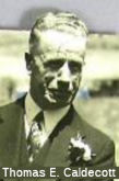 The "Caldecott Tunnel" (structure 28-015) (~ ALA R5.858 to CC R0.416) on Route 24 between Alameda and Contra Costa Counties was named
for Thomas Edwin Caldecott (July 27, 1878 – July 23, 1951), who was
a pharmacist and politician when the tunnel was built. From 1923,
Caldecott served in politics in Alameda County, California in the San
Francisco Bay Area until 1951. Caldecott was born in Chester, England on
July 27, 1878. Both of his parents were Welsh. The family immigrated to
Toronto, Ontario, Canada about 1882. Caldecott grew up in Canada, and
obtained a pharmacy degree from the University of Toronto in 1900. Thomas
and his brother visited Berkeley, California, and shortly thereafter in
1903, moved their entire family there. That same year, Caldecott bought a
pharmacy at Dwight Way and Shattuck Avenue, later moved to Ashby Avenue
and Adeline Street in the Webb Block, a building which was designated a
local landmark in 2004. Caldecott was elected to the City Council of
Berkeley in 1923. In 1930, he was appointed to fill out the remaining term
of Mayor Michael B. Driver. He then successfully ran for the office of
Mayor in 1931, serving until December 1932. He was then elected as a
supervisor on the Alameda County Board of Supervisors, serving from 1933
until his death in 1951. He was chairman of the board from 1945-1946. In
1948, he formed the Alameda County Highway Committee, "to solve sectional
differences over highway problems." He was also instrumental in
establishing a new Alameda County Juvenile Hall, which was completed after
his death in 1951. Caldecott served as the president of Joint Highway
District 13, which oversaw the construction of the multi-bore Broadway Low
Level Tunnel through the Berkeley Hills east of San Francisco Bay. When
opened in 1937,[14] it was the longest tunnel in the State of California,
and accomplished the opening up of the entire region east of the hills as
a major suburb of the Bay Area. At an event that year, Caldecott was
honored "as the man responsible for the success of the project". In 1941,
Caldecott was publicly commended for his "untiring efforts" in bringing
the project to a successful completion. In 1960, the tunnel was re-named
the "Caldecott Tunnel", in recognition of his leadership on the project.
The tunnel was originally called the "Broadway Low-level" Tunnel
(the former tunnel through the Oakland hills was at a much higher
elevation.) It was built in 1937 and refurbished in 1965, and was named by
Assembly Concurrent Resolution 8 in 1969.
The "Caldecott Tunnel" (structure 28-015) (~ ALA R5.858 to CC R0.416) on Route 24 between Alameda and Contra Costa Counties was named
for Thomas Edwin Caldecott (July 27, 1878 – July 23, 1951), who was
a pharmacist and politician when the tunnel was built. From 1923,
Caldecott served in politics in Alameda County, California in the San
Francisco Bay Area until 1951. Caldecott was born in Chester, England on
July 27, 1878. Both of his parents were Welsh. The family immigrated to
Toronto, Ontario, Canada about 1882. Caldecott grew up in Canada, and
obtained a pharmacy degree from the University of Toronto in 1900. Thomas
and his brother visited Berkeley, California, and shortly thereafter in
1903, moved their entire family there. That same year, Caldecott bought a
pharmacy at Dwight Way and Shattuck Avenue, later moved to Ashby Avenue
and Adeline Street in the Webb Block, a building which was designated a
local landmark in 2004. Caldecott was elected to the City Council of
Berkeley in 1923. In 1930, he was appointed to fill out the remaining term
of Mayor Michael B. Driver. He then successfully ran for the office of
Mayor in 1931, serving until December 1932. He was then elected as a
supervisor on the Alameda County Board of Supervisors, serving from 1933
until his death in 1951. He was chairman of the board from 1945-1946. In
1948, he formed the Alameda County Highway Committee, "to solve sectional
differences over highway problems." He was also instrumental in
establishing a new Alameda County Juvenile Hall, which was completed after
his death in 1951. Caldecott served as the president of Joint Highway
District 13, which oversaw the construction of the multi-bore Broadway Low
Level Tunnel through the Berkeley Hills east of San Francisco Bay. When
opened in 1937,[14] it was the longest tunnel in the State of California,
and accomplished the opening up of the entire region east of the hills as
a major suburb of the Bay Area. At an event that year, Caldecott was
honored "as the man responsible for the success of the project". In 1941,
Caldecott was publicly commended for his "untiring efforts" in bringing
the project to a successful completion. In 1960, the tunnel was re-named
the "Caldecott Tunnel", in recognition of his leadership on the project.
The tunnel was originally called the "Broadway Low-level" Tunnel
(the former tunnel through the Oakland hills was at a much higher
elevation.) It was built in 1937 and refurbished in 1965, and was named by
Assembly Concurrent Resolution 8 in 1969.
(Image source: Oakland Museum; Bio information: Wikipedia)
 The fourth bore of the Caldecott Tunnel (Route 24,~ CC R0.071) is named the Representative
Ellen O’Kane Tauscher Memorial Bore. It was named in memory
of Ellen O’Kane Tauscher, a dedicated public servant serving the
10th Congressional District from 1997–2009. Ellen O’Kane was
born in Newark, New Jersey, in November 1951, the daughter of a grocery
store owner. She earned a degree in early childhood education from Seton
Hall University in 1974. In her mid-20s, she became one of the first women
to hold a seat on the New York Stock Exchange, serving from 1977–79,
and during her 14-year Wall Street career, she also served as an officer
of the American Stock Exchange. In 1989, Ellen O’Kane married
William Tauscher and raised a daughter, Katherine. The couple later
divorced. In 1992, Ellen O’Kane Tauscher founded a service for
preemployment screening of childcare providers. She later authored the
Child Care Sourcebook. She also created the Tauscher Foundation, which
donated two hundred thousand dollars ($200,000) to California and Texas
schools to buy computer equipment for elementary education. Ellen
O’Kane Tauscher received her first political experience serving as
the state cochair for Dianne Feinstein’s successful 1992 and 1994
Senate campaigns. In 1996, Ellen O’Kane Tauscher challenged
incumbent California Republican Representative William P. Baker in a newly
created Delta district comprising bedroom communities that are the most
conservative in the San Francisco Bay area. She ran on a platform of gun
control, women’s reproductive rights, and increased spending on
education, along with the reduction of wasteful fiscal spending and
narrowly won, with 49 percent of the vote to Baker’s 47 percent, in
a race with three minor party candidates. In the next two elections,
Representative Tauscher won by slightly more comfortable margins over
Republican candidates, defeating Charles Ball 53 percent to 43 percent and
Claude B. Hutchinson 52 percent to 44 percent. When Representative
Tauscher took her seat in the 105th Congress (1997–1999), she was
assigned to three committees: National Security (later renamed Armed
Services); Science, Space, and Technology; and Transportation and
Infrastructure. In the 106th Congress (1999–2001), Representative
Tauscher resigned her Science, Space, and Technology Committee seat to
focus on her two other assignments, where she remained for the balance of
her career in the House of Representatives. Representative
Tauscher’s committee assignments provided her a national platform
from which she also was able to serve district needs. As a member of the
Armed Services Committee, she outlined an activist role for the United
States in the international arena. Her district was the only one having
two national defense laboratories, Lawrence Livermore and Sandia, and she
secured nearly $200,000,000 in funding for Livermore’s “super
laser” project. Representative Tauscher also had a prominent role as
the senior Democrat on the congressional panel overseeing the National
Nuclear Security Administration, which manages the United States nuclear
weapons program. From her seat on the Transportation and Infrastructure
Committee, Representative Tauscher steered federal funding to improve the
San Francisco Bay area’s badly strained transportation systems,
including $33,000,000 for projects in her district. In 1998, Time magazine
dubbed her moderate Democratic approach to politics
“Tauscherism,” a kind of middle-of-the-road politics that
blended fiscal conservatism with social liberalism and reflected the
political realities of her suburban district, which, until reapportionment
in 2002, was more Republican than Democratic. When the lines were redrawn
by the California Legislature, Representative Tauscher easily won
reelection to a fourth term, with 75 percent of the vote against
Libertarian candidate Sonia E. Harden. In 2004, Representative Tauscher
won reelection with 66 percent of the vote against Republican Jeff
Ketelson, and in 2006 and 2008 voters returned her to office with 66
percent and 65 percent of the vote, respectively. On May 5, 2009,
Representative Tauscher was nominated by President Barack Obama to be the
Under Secretary of State for Arms Control and International Security. On
June 25, 2009, Representative Tauscher was confirmed to the position of
Under Secretary of State by a voice vote of the United States Senate and
resigned her seat in Congress the next day to take the position.
Representative Tauscher represented the United States at numerous
international meetings and negotiations, including setting into motion the
New START Treaty, the first major nuclear arms reduction and limitation
agreement with Russia in over two decades, which was signed in 2009, and
ratified in 2010. Representative Tauscher served the Obama administration
as Under Secretary of State until February 7, 2012, when she was named
Special Envoy for Strategic Stability and Missile Defense, a position she
held until August 31, 2012. In 2013, Representative Tauscher was elected
chairperson of the Alliance for Bangladesh Worker Safety, a group of 28
global retailers, and led efforts that created industry safety standards
in response to the fire and collapse of a Bangladeshi garment factory that
killed over 1,000 workers. In March 2013, Governor Edmund G. Brown, Jr.,
appointed Representative Tauscher as the chair of the Governor’s
Military Council and was tasked with expanding defense industry jobs and
investment in California. On September 17, 2013, Representative Tauscher
was named as an independent member of the Board of Governors for Lawrence
Livermore National Laboratory and Los Alamos National Laboratory, and
served as chair of the Board of Governors beginning on February 16, 2018.
On June 2, 2017, Governor Edmund G. Brown, Jr., appointed Representative
Tauscher to serve on the Board of Regents of the University of California.
She passed away in 2019. Named by Senate Concurrent Resolution 77, Res.
Chapter 32, 09/11/20.
The fourth bore of the Caldecott Tunnel (Route 24,~ CC R0.071) is named the Representative
Ellen O’Kane Tauscher Memorial Bore. It was named in memory
of Ellen O’Kane Tauscher, a dedicated public servant serving the
10th Congressional District from 1997–2009. Ellen O’Kane was
born in Newark, New Jersey, in November 1951, the daughter of a grocery
store owner. She earned a degree in early childhood education from Seton
Hall University in 1974. In her mid-20s, she became one of the first women
to hold a seat on the New York Stock Exchange, serving from 1977–79,
and during her 14-year Wall Street career, she also served as an officer
of the American Stock Exchange. In 1989, Ellen O’Kane married
William Tauscher and raised a daughter, Katherine. The couple later
divorced. In 1992, Ellen O’Kane Tauscher founded a service for
preemployment screening of childcare providers. She later authored the
Child Care Sourcebook. She also created the Tauscher Foundation, which
donated two hundred thousand dollars ($200,000) to California and Texas
schools to buy computer equipment for elementary education. Ellen
O’Kane Tauscher received her first political experience serving as
the state cochair for Dianne Feinstein’s successful 1992 and 1994
Senate campaigns. In 1996, Ellen O’Kane Tauscher challenged
incumbent California Republican Representative William P. Baker in a newly
created Delta district comprising bedroom communities that are the most
conservative in the San Francisco Bay area. She ran on a platform of gun
control, women’s reproductive rights, and increased spending on
education, along with the reduction of wasteful fiscal spending and
narrowly won, with 49 percent of the vote to Baker’s 47 percent, in
a race with three minor party candidates. In the next two elections,
Representative Tauscher won by slightly more comfortable margins over
Republican candidates, defeating Charles Ball 53 percent to 43 percent and
Claude B. Hutchinson 52 percent to 44 percent. When Representative
Tauscher took her seat in the 105th Congress (1997–1999), she was
assigned to three committees: National Security (later renamed Armed
Services); Science, Space, and Technology; and Transportation and
Infrastructure. In the 106th Congress (1999–2001), Representative
Tauscher resigned her Science, Space, and Technology Committee seat to
focus on her two other assignments, where she remained for the balance of
her career in the House of Representatives. Representative
Tauscher’s committee assignments provided her a national platform
from which she also was able to serve district needs. As a member of the
Armed Services Committee, she outlined an activist role for the United
States in the international arena. Her district was the only one having
two national defense laboratories, Lawrence Livermore and Sandia, and she
secured nearly $200,000,000 in funding for Livermore’s “super
laser” project. Representative Tauscher also had a prominent role as
the senior Democrat on the congressional panel overseeing the National
Nuclear Security Administration, which manages the United States nuclear
weapons program. From her seat on the Transportation and Infrastructure
Committee, Representative Tauscher steered federal funding to improve the
San Francisco Bay area’s badly strained transportation systems,
including $33,000,000 for projects in her district. In 1998, Time magazine
dubbed her moderate Democratic approach to politics
“Tauscherism,” a kind of middle-of-the-road politics that
blended fiscal conservatism with social liberalism and reflected the
political realities of her suburban district, which, until reapportionment
in 2002, was more Republican than Democratic. When the lines were redrawn
by the California Legislature, Representative Tauscher easily won
reelection to a fourth term, with 75 percent of the vote against
Libertarian candidate Sonia E. Harden. In 2004, Representative Tauscher
won reelection with 66 percent of the vote against Republican Jeff
Ketelson, and in 2006 and 2008 voters returned her to office with 66
percent and 65 percent of the vote, respectively. On May 5, 2009,
Representative Tauscher was nominated by President Barack Obama to be the
Under Secretary of State for Arms Control and International Security. On
June 25, 2009, Representative Tauscher was confirmed to the position of
Under Secretary of State by a voice vote of the United States Senate and
resigned her seat in Congress the next day to take the position.
Representative Tauscher represented the United States at numerous
international meetings and negotiations, including setting into motion the
New START Treaty, the first major nuclear arms reduction and limitation
agreement with Russia in over two decades, which was signed in 2009, and
ratified in 2010. Representative Tauscher served the Obama administration
as Under Secretary of State until February 7, 2012, when she was named
Special Envoy for Strategic Stability and Missile Defense, a position she
held until August 31, 2012. In 2013, Representative Tauscher was elected
chairperson of the Alliance for Bangladesh Worker Safety, a group of 28
global retailers, and led efforts that created industry safety standards
in response to the fire and collapse of a Bangladeshi garment factory that
killed over 1,000 workers. In March 2013, Governor Edmund G. Brown, Jr.,
appointed Representative Tauscher as the chair of the Governor’s
Military Council and was tasked with expanding defense industry jobs and
investment in California. On September 17, 2013, Representative Tauscher
was named as an independent member of the Board of Governors for Lawrence
Livermore National Laboratory and Los Alamos National Laboratory, and
served as chair of the Board of Governors beginning on February 16, 2018.
On June 2, 2017, Governor Edmund G. Brown, Jr., appointed Representative
Tauscher to serve on the Board of Regents of the University of California.
She passed away in 2019. Named by Senate Concurrent Resolution 77, Res.
Chapter 32, 09/11/20.
(Image source: Find a Grave)
 Interstate Submissions
The portion from Route 13 to Walnut Creek was submitted for inclusion in the interstate system in 1945; it was not accepted.
 Scenic Route
[SHC 263.3] From the Alameda-Contra Costa county line to Route 680 in Walnut Creek.
Eligible for Scenic Highway status per [SHC 263.2]. The following portions have been officially designated as Scenic Highway and are signed:
 Classified Landcaped Freeway
The following segments are designated as Classified Landscaped Freeway:
| County | Route | Starting PM | Ending PM |
| Alameda | 24 | R1.85 | R4.88 |
| Alameda | 24 | R5.24 | R5.89 |
| Contra Costa | 24 | R0.40 | R0.62 |
| Contra Costa | 24 | R1.82 | R2.85 |
| Contra Costa | 24 | R3.29 | R5.26 |
| Contra Costa | 24 | R5.53 | R9.14 |
From Route 680 in Walnut Creek to Route 4 near Pittsburg.
Post 1964 Signage History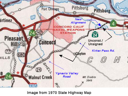
 In 1963, this segment was defined as "Route 680
in Walnut Creek to Route 4 near Pittsburg." In 1981, Chapter 292 changed
the wording to "near Walnut Creek", but it was changed back to "in Walnut
Creek" by Chapter 1187 in 1990.
In 1963, this segment was defined as "Route 680
in Walnut Creek to Route 4 near Pittsburg." In 1981, Chapter 292 changed
the wording to "near Walnut Creek", but it was changed back to "in Walnut
Creek" by Chapter 1187 in 1990.
Planning maps have shown a routing that follows Willow Pass road from Walnut Creek to just outside of Antioch. Until 1991, Route 242 between Concord and Route 4 was signed as Route 24, but field reports indicate this is no longer the case. There is one map that shows Route 24 continuing northeast of Route 4 to Collinsville and then towards Route 160
In Concord, the freeway routing was constructed by 1992; that routing was transferred to Route 242. The 2013 Traversable Routing report notes that the traversable routing that corresponds to the proposed bypass is Ygnacio Valley Road and Kirker Pass Road. The extension of Ygnacio Valley Road between Oak Grove and Pirker Pass Road was constructed by the county in 1956, financed by a 1952 County Road Bond, the Division of Highways, and the Federal Bureau of Public Works. The traversable routing was considered adequate in 1972, but local agencies have discouraged state adoption. The freeway route adoption was rescinded effective 4/16/1975.
Pre 1964 Signage HistoryThe new routing is LRN 256, added to the state highway system in 1959.
Sign Route 24 used the present-day Route 242 routing until 1992, at which point Route 242 was created. Sign Route 24 originally ran along Monument Blvd and Willow Pass Road. By 1947, it had been rerouted to Concord Avenue and the future Route 242 routing [Ed: Still investigating the name]. That routing was part of LRN 75.
StatusIn June 2011, it was reported that the Walnut Creek City Council had a number of plans for Ygnacio Valley Road, including in-pavement lights at various locations, $550,000; Ygnacio Valley Road sidewalk, Oakland Boulevard to Parkside Drive, $750,000; speed display signs along Ygnacio Valley, $130,000; left turn extension lanes at Ygnacio Valley and San Carlos Drive, $500,000; southbound left turn extension lane at Civic Drive and Ygnacio Valley, $600,000; eastbound left turn extension at Ygnacio Valley and Marchbanks Drive, $300,000; westbound left turn extension on Ygnacio Valley at Walnut Boulevard, $400,000; and a westbound left turn extension on Ygnacio Valley at Homestead Avenue, $350,000.
In July 2026, the Bay Area MTC released the Draft 2027 Transportation
Improvement Program (TIP) for comments. One of the projects/allocations in
the program was: TIP ID CC-250204; $35,200,000; Kirker Pass Road
Southbound Truck Climbing Lane. Contra Costa County: Install an
additional truck climbing lane in the southbound direction of Kirker Pass
Road starting 1,200 south of Nortonville Road to Concord City Limit and
provide intersection improvements at the south Hess Road intersection in
unincorporated Concord.
(Source: MTC Draft TIP, 8/13/2026; MTC 2027 Transportation Improvement Program Projects Interactive Map)
 Prior to 1964, Route 24 continued from Pittsburgh to a junction
with US 395 near Hallelujah Junction via Oroville and Quincy. This segment
was renumbered and reallocated as part of the 1964 "Great Renumbering"
Prior to 1964, Route 24 continued from Pittsburgh to a junction
with US 395 near Hallelujah Junction via Oroville and Quincy. This segment
was renumbered and reallocated as part of the 1964 "Great Renumbering"
Post 1964 Signage HistoryThe 1964 renumbering reallocated the segments E of Pittsburgh as follows:
Pre 1964 Signage History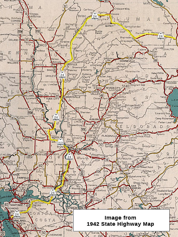
 From Sign Route 4 (Route 24's present-day terminus), it continued
cosigned with Sign Route 4 between from near Concord to near Antioch. This
was LRN 75, defined in 1931. In 1964, this segment was renumbered as Route 4.
From Sign Route 4 (Route 24's present-day terminus), it continued
cosigned with Sign Route 4 between from near Concord to near Antioch. This
was LRN 75, defined in 1931. In 1964, this segment was renumbered as Route 4.
Sign Route 24 then ran N to Sacramento, following the route of
present-day Route 160, entering along Freeport Blvd. This was LRN 11,
defined in 1933. It originally ran N on Freeport to Broadway.
In Sacramento, Route 24 ran W along Broadway as part of LRN 50. It
then ran N along 3rd/5th St., also as part of LRN 50
(Sign Route 16, defined in 1933). It continued N to "I" street, co-signed
with Sign Route 16. This is now signed as Route 16.
Prior to 1960, Sign Route 24 continued W out of the city co-signed
with Sign Route 16 along LRN 50 to Woodland. Again, this is now just Route 16.
In Woodland, Sign Route 24 diverged from Route 16 and continued N
to Yuba City/Marysville along LRN 87. It was cosigned with US 40A, and
this segment is now part of Route 113.
From Woodland, Sign Route 24 ran along the
route from Woodland at Jct. US 99 to Jct. Sigh Route 7 (later renumbered
as US 395) near Reno Junction, via Oroville and Quincy (Reno Junction was
the former name of what is now Hallelujah Junction, Reno Junction having
replaced Chats). Signage as Sign Route 24 started in 1934.
 In 1954, Sign Route 24 was either co-signed or resigned as Alt US 40
(US 40A). The article announcing the designation indicated that existing
signs would be replaced by US 40 signs with the designation "Alt". The
article indicated that for the first 10 miles N, from US 40 in Solano
County, the new alternate route would be designated as US 99W and US 40A.
A new section of highway was being constructed to intersect with the
existing US 99W at the Woodland Wye. This would be the segment that is now
Route 113. In Woodland, US40A joined with the existing US 99W / Sign Route 24 to Yuba City; this is now Route 113. US 40A then followed Sign Route 24
(now Route 70) through Oroville and Quincy to US 395. Lastly, US 40A
followed US 395 S to Reno, which was the eastern terminus of US 40A. The
goal here was to provide an alternate route across the Sierras when Donner
Pass was closed. Note that some maps from the early 1950s also show Sign
Route 24 being extended from Hallelujah Jct. to the Nevada State boundary
along US 395.
In 1954, Sign Route 24 was either co-signed or resigned as Alt US 40
(US 40A). The article announcing the designation indicated that existing
signs would be replaced by US 40 signs with the designation "Alt". The
article indicated that for the first 10 miles N, from US 40 in Solano
County, the new alternate route would be designated as US 99W and US 40A.
A new section of highway was being constructed to intersect with the
existing US 99W at the Woodland Wye. This would be the segment that is now
Route 113. In Woodland, US40A joined with the existing US 99W / Sign Route 24 to Yuba City; this is now Route 113. US 40A then followed Sign Route 24
(now Route 70) through Oroville and Quincy to US 395. Lastly, US 40A
followed US 395 S to Reno, which was the eastern terminus of US 40A. The
goal here was to provide an alternate route across the Sierras when Donner
Pass was closed. Note that some maps from the early 1950s also show Sign
Route 24 being extended from Hallelujah Jct. to the Nevada State boundary
along US 395.
(Source: Roseville Press-Tribune 3/23/1954 via Joel Windmiller
(email), 11/12/2023)
According to Chris Sampang and Joel Windmiller, the following are some former routings of US 40A/Route 24 between Woodland and Reno:
Chris also notes that Scott Road north of Reno Junction to just south of Omira was also US 395 pre-expressway. Constantia Road between Omira and Doyle, Doyle Loop in Doyle itself, and Old Highway from Doyle to just west of Lassen County Route A26 also appear to be former alignment (Old Highway passes south of the Doyle State Wildlife Area, but the current US 395 expressway goes right through it between Laver Crossing and Lassen County Sign Route A26.)
Around 1960 the routing changed to a new routing along LRN 232, which used Jiboom Street and El Centro Street. This routing used the original Jiboom Street bridge over the American River and Main Drainage Canal. The Gribblenation Blog, "Highways in and around Old Sacramento; US 40, US 99W, CA 16, CA 24, CA 70, CA 99, CA 275, and more" provides a detailed history of the various highways (US 40, US 99, Route 16, Route 24, Route 70, Route 99, Route 275, Route 51, I-5, and I-80 in the Old Sac area.
"I" Street Bridge - Sacramento
The predecessor to the I Street Bridge at the
Sacramento River was constructed by the California Pacific Railroad
Company. The structure was located just north of modern I Street and
became functional on January 29, 1870, when the first train crossed. This
structure only served trains. The Central Pacific Railroad was acquired by
the Southern Pacific Railroad in 1885, but continued to operate as a
leased line. The Southern Pacific Railroad, Yolo County and Sacramento
County came to an agreement on construction of the I Street Bridge on
February 14, 1910. The project initially faced difficulties due to the
hesitancy of Yolo County due to the lack of support by the Northern
Electric Railroad. The Southern Pacific eventually threatened not to
construct an automotive road deck atop the structure which saw Yolo County
relent. Yolo County would officially endorse construction of a road deck
atop the I Street Bridge on September 8, 1910. Construction of the I
Street had commenced on June 8, 1910. The structure would be completed on
April 29, 1912, at a cost of approximately $1,000,000. Like the 1870-era
railroad span the I Street Bridge retained a turntable swing design.
(Source: Gribblenation Blog (Tom Fearer), "I Street Bridge (former California State Route 16 the Sacramento River)", 10/24/2025)
Originally, LRN 6 used the "I" Street Bridge. The I
Street Bridge opened to traffic over the Sacramento River in 1912 as a
swing span. It is is owned by the Union Pacific Railroad. The top deck of
this 400-foot-long structure carries automotive traffic from I Street in
Sacramento to C Street in West Sacramento. The bottom deck carries the
tracks of the Union Pacific Railroad. By 1917, LRN 6 departed Sacramento
westward via the I Street Bridge to Washington (now West Sacramento).
Prior to the construction of the Yolo Causeway, a primitive seasonal road
known as "Tule Jake Road" could be utilized to traverse Yolo Basin by car
between West Sacramento and Davis (seasonal, as the Yolo basin flooded six
to eight months every year). After completion of the Yolo Causeway (then
referred to as the Yolo Basin Trestle) between West Sacramento and Davis,
LRN 6 was moved to the "M" Street Bridge, which eliminated a rail overpass
from the alignment. In 1935, the "I" Street Bridge became part of LRN 50
as part of the 1935 codification of LRN 50 as "[LRN 15] to Sacramento via
Rumsey and Woodland" (previously, LRN 50 had ended in Woodland); the "I"
Street Bridge was then signed as part of Sign Route 16. The structure
became part of Sign Route 24 when that highway was extended to Oakland in
1935.
(Source: Gribblenation Blog (Tom Fearer), "The history of Sacramento's Tower Bridge (Currently California State Route 275 and former US Routes 40/99W)", 10/8/2025;Gribblenation Blog (Tom Fearer), "I Street Bridge (former California State Route 16 the Sacramento River)", 10/24/2025)
In 1935, the Jibboom Street Overhead was announced as a
recommended project. The proposed span would serve as a connection between
Jibboom Street and the I Street Bridge. Concepts of the Jibboom Street
Overhead noted that the project was planned as a Federal cooperative and
included a replacement for the original eastern approach to the I Street
Bridge. The original eastern approach landed at I Street just west of 2nd
Street. The new approach was planned to be elongated towards 3rd
Street. Jibboom Street originally connected to 2nd Street via
an at-grade crossing of the Southern Pacific Railroad. The Jibboom Street
Overhead and realigned eastern approach to the I Street Bridge were
dedicated by the Governor on October 1, 1937. In 1949, Legislative Chapter
1467 defined a duplicate LRN 207 as a new State Highway between Sacramento
and Marysville; this highway incorporated the Jibboom Street Overhead
branching north of the I Street Bridge. The corridor was originally
subject to the provisions of the Collier Burns Act of 1947 regarding
maintenance. The duplicate LRN 207 was renumbered as LRN 232 in 1951; the
Collier Burns Act provision the highway was subject to was removed in
1955. Sign Route 24 would continue to use the I Street Bridge until it was
realigned onto the Jibboom Street Bridge (LRN 232) in 1960.
(Source: Gribblenation Blog (Tom Fearer), "I Street Bridge (former California State Route 16 the Sacramento River)", 10/24/2025)
Over on AAroads, Scott Parker noted the following about the I-Street routing: The original LRN 232 (after 1958 signed as Route 24) diverged from LRN 50/Route 16 at the intersection of the I Street extension bridge immediately east of the Sacramento River swing-span (shared with UP/former SP tracks on the lower/ground level deck) and Jibboom Street (both are elevated over the RR tracks). It headed north on Jibboom over a through-truss bridge crossing the American River; the street ended at Garden Highway—atop the river levee—at which point LRN 232/Route 24 turned west. About a mile west of there, the state highway diverged from Garden Highway along a broad arc descending north from the levee onto El Centro Avenue, which it utilized north into Sutter County. LRN 232 and Route 24 terminated at LRN 3/US 99E at a diamond interchange in Olivehurst.
After 1964, Route 99 was defined as running through
Sacramento and Route 70 was originally signed to terminate at Capitol
Mall. Route 99 and Route 70 would initially use the eastern I Street
Bridge approach to reach the Jibboom Street Overhead. These were temporary
routings. In 1970, following the completion of I-5 north of downtown
Sacramento during the late 1960s, both Route 99 and Route 70 were moved to
I-5 and would multiplex the freeway.
(Source: Gribblenation Blog (Tom Fearer), "I Street Bridge (former California State Route 16 the Sacramento River)", 10/24/2025)
The I Street Bridge was removed as part of the State
Highway System and as part of California State Route 16 in 1984.
(Source: Gribblenation Blog (Tom Fearer), "I Street Bridge (former California State Route 16 the Sacramento River)", 10/24/2025)
In October 2018, it was reported that the City of
Sacramento and Caltrans have initiated a project that will replace the
historic I-Street Bridge (for vehicular traffic) and the Jibboom Street
approach to the bridge for a new vehicular continuation of Railyards Blvd.
to C Street. The I Street Bridge is 100 years old (and is a former routing
of Sign Route 16 and Sign Route 24 (as LRN 50)) and the lanes are too
narrow to serve buses, there are no bicycle lanes, and sidewalks are too
narrow to meet accessibility standards. The I Street Bridge and the four
associated approach structures are on the eligible bridge list for federal
funds for replacement and/or rehabilitation through the Highway Bridge
Program (HBP). The I Street Bridge has been classified as functionally
obsolete, and the existing approach structures have been classified as
structurally deficient. The I Street Bridge Replacement project will
include construction of a new bridge upstream of the existing I Street
Bridge. The new bridge will cross the Sacramento River between the
Sacramento Railyards and the West Sacramento Washington planned
developments and provide a new bicycle, pedestrian, and automobile
crossing. The existing I Street Bridge would continue to be used by the
railroad. The approach viaducts to the existing I Street Bridge will be
demolished, which should result in better access to the water front in
both cities. (See Route 16 for the new routing)
(Source: City of Sacramento, I-Street Bridge Replacement)
Over on AAroads, Scott Parker (Sparker) noted the following about the I-Street routing: The original LRN 232 (after 1959 signed as Route 24) diverged from LRN 50/Route 16 at the intersection of the I Street extension bridge immediately east of the Sacramento River swing-span (shared with UP/former SP tracks on the lower/ground level deck) and Jiboom Street (both are elevated over the RR tracks). It headed north on Jiboom over a through-truss bridge crossing the American River; the street ended at Garden Highway — atop the river levee —, at which point LRN 232/Route 24 turned west. About a mile west of there, the state highway diverged from Garden Highway along a broad arc descending north from the levee onto El Centro Avenue, which it utilized north into Sutter County. LRN 232 and Route 24 terminated at LRN 3/US 99E at a diamond interchange in Olivehurst.
In November 2022, it was reported that the plan to turn
the top level of the I Street Bridge into a pedestrian walkway and bike
lane over the Sacramento River was progressing. In Fall 2022, project
planners filed financial documents, and in late October 2022 the project
was recommended for a $16 million grant through the state’s Active
Transportation Program. The current bridge will be superseded by a new
bridge between C Street in West Sacramento and the Railyards — a
$260 million, 300-foot-long feat of architecture that will replace the I
Street Bridge as the route cars take over the river. As for the old
bridge, the plan is to use the 111-year-old I Street Bridge for railroad
traffic, which runs on the bottom deck of the bridge. As for the top? The
city of West Sacramento has spearheaded the plan to repair the
bridge’s narrow sidewalk and turn the vehicle lanes into a bicycle
track and walkway. The $16 million state grant still has to be formally
approved by the state Transportation Commission. The Sacramento Area
Council of Governments previously awarded the project $3.6 million to
complete the final design and right-of-way phase. The total cost of
planning and constructing the project is estimated at $22.6 million. After
securing more than $19 million in outside funding, the city will pay the
rest. Final planning should be complete and construction could be ready to
begin in or before 2026 — but that will largely depend on the timing
of the completion of the new Railyards bridge. The plan is to be ready so
that as soon as the new bridge is cleared to start taking vehicle traffic,
the deck conversion of the old bridge can start. The project should be
finished by late 2027 or 2028.
(Source: Sacramento Business News, 11/7/2022)
In December 2022, it was reported that the CTC approved
$16 million for the I Street Bridge Deck Conversion Project. This project
will repurpose and modernize the historic I Street Bridge to close an
active transportation gap and foster economic development between
low-income and disadvantaged neighborhoods in West Sacramento and
Sacramento. The project will construct and connect new Americans with
Disabilities Act compliant bicycle/pedestrian ramps on both sides of the
Sacramento River and enhance the upper deck to facilitate and encourage
active transportation between the two cities.
(Source: Appeal Democrat, 12/9/2022)
In December 2023, it was reported that Construction on
a new bridge connecting West Sacramento and the Railyards is anticipated
to begin in 2025. Currently, the I Street Bridge replacement project is
not fully funded, and construction will begin once all financial support
is secured. So far, officials have completed the environmental
documentation, and are working through the permits, right-of-way
acquisition and final design. Even after construction starts it’ll
be a while before the new bridge graces the city. The project will take
approximately four years to construct to comply with environmental
mitigation and flood control work windows. If construction begins in 2025,
the new bridge would be completed by 2029. The existing I Street Bridge is
more than 110 years old; the nine-foot lanes are too narrow to serve
buses, there are no bicycle lanes, and the sidewalks are too narrow to
meet current accessibility standards. A new bridge will be built upstream
from the current one and will cross the Sacramento River, connecting the
Railyards to West Sacramento’s Washington neighborhood. The current
bridge will remain and serve as a railroad crossing on the lower deck, the
city said, while the upper deck may be used by pedestrians and bicyclists.
The new vertical lift bridge will feature 6-foot bike lanes and 12-foot
shared paths for pedestrians and bicyclists. It can also withstand more
than 25,000 vehicles daily, according to the city’s 2020 news
release. The bridge’s contemporary blueprint is bolstered by two
curved green and white pillars on each side, which light up at night.
(Source: Sacramento Bee, 12/15/2023)
In October 2025, the CTC approved for future
consideration of funding 03-Sacramento County. I Street Bridge
Replacement Project. New two-lane bridge to replace existing
two-lane vehicle crossing. (FEIR) (PPNO 1809). The Project is located over
the Sacramento River and within the City of Sacramento in Sacramento
County and the City of West Sacramento in Yolo County. The existing I
Street Bridge and approach work are located between 3rd Street
in Sacramento to 5th Street in West Sacramento. The new bridge
location would be approximately 1,000 feet north of the existing I Street
Bridge. The Project would replace the two-lane vehicle crossing (that is
currently accommodated by the existing I Street Bridge) with a two-lane
bridge on a new alignment. The new bridge would be 860 feet long with a
330-foot-long vertical lift movable bridge center span. The new bridge
would have Class II buffered bicycle lanes and sidewalks on both sides.
The Project includes partial or full removal of five bridge approaches.
The Project is estimated to cost $334,738,000 and is funded through
construction with Highway Bridge Program ($264,031,000), City of
Sacramento local ($17,355,000), City of West Sacramento local
($17,352,000), Regional Surface Transportation Program ($11,000,000), and
Local Partnership Program ($25,000,000) funds. Construction for the
Project began in Fiscal Year 2025-26. For more details, see the full agenda item background.
(Source: October 2025 CTC Agenda, Agenda Item 2.2c.(4))
In February 2026, it was reported that a major
financial hurdle was cleared following a vote by the Sacramento
Transportation Authority to approve the project's financing framework for
the I Street Bridge Replacement Project. Leaders say the project is fully
funded, primarily through federal and state dollars. But that money
arrives incrementally, not right away. The framework establishes a line of
credit to provide cash flow for the construction costs, and STA has
graciously stepped forward to be the lead in procuring that financing.
Bids should be opened in March. As for what happens to the existing I
Street bridge, the landmark river crossing is here to stay. West
Sacramento is taking the lead on that project, and is going to maintain
that upper-level deck for bike and pedestrian pathways. The construction
start date depends on many factors, including how long the bid process
takes. Right now, they are projecting that construction could break ground
as soon as late May 2026. It is expected to take four years to build the
bridge, with construction projected to wrap up in the summer of 2030.
(Source: CBS News Sacramento, 2/25/2026)
In April 2026, it was reported that the I Street Bridge
replacement project, designed to connect West Sacramento and the
Sacramento railyards, is facing delays after construction bids exceeded
the $300 million estimate. The new bridge will replace the current span,
which was built in 1911. When the initial round of bids were opened, the
city received three bids ranging from $398 million to $517 million, far
above the anticipated budget, with rising steel costs driving the
increase. The lowest bid was $78 million above the high end of the
original estimate. The project was originally scheduled to begin
construction this year, but officials say global uncertainty and tariffs
have contributed to the significant cost increase. West Sacramento has
committed up to $21.2 million toward the project, but even with the
removal of some decorative elements, officials say the overall cost
won’t decrease significantly. City staff are expected to recommend
rejecting the current bids and will reach out to contractors to get a
better idea of current market conditions.
(Source: KCRA 3 Sacramento, 4/16/2026)
Sign Route 24 from Yuba City to Quincy
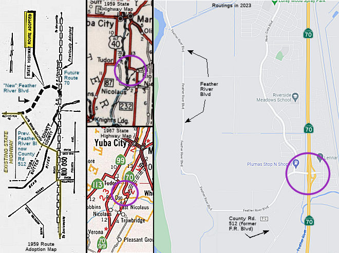 In 1959, the CHC adopted a routing for a connection between the "future Route 232 (LRN 232) freeway"
(today's Route 70 freeway routing) and the existing Route 232 highways
(Feather River Blvd) near Rio Oso. This connector swings W from the
adopted freeway route to join Feather River Blvd about a mile to the west.
It is hard to see today, because although Feather River Blvd was "new"
Route 24 (and later Route 70) at the time, it has since been relinquished
by the state and downgraded to a county road. The plans called for the
building of a two-lane bridge over the Bear River, upstream from the
existing bridge. This is part of the first stage of construction of the
new Route 70 freeway. The article indicated that when the LRN 232 freeway
(today's Route 70) was extended to US 99E (Route 99) in Marysville, this
connection would be incorporated into the Bear River interchange, and used
as a county road connection (as LRN 232 would move off Feather River
Blvd). However, in 1959, Feather River Blvd was new Route 24 headed north
on El Centro Road from the Sacramento River. Old Route 24 resigned the Alt
US 40 1955-64 alignment (current 113) from Woodland, which headed north at
Tudor at the current junction of Route 99 and Route 113 then headed north
into Yuba City. In this area for a small period of time (i.e., from 1964
until I-5 was completed and US 99 signs came down), California had both US 99 and California Route 99, but not on the same stretch of highway.
In 1959, the CHC adopted a routing for a connection between the "future Route 232 (LRN 232) freeway"
(today's Route 70 freeway routing) and the existing Route 232 highways
(Feather River Blvd) near Rio Oso. This connector swings W from the
adopted freeway route to join Feather River Blvd about a mile to the west.
It is hard to see today, because although Feather River Blvd was "new"
Route 24 (and later Route 70) at the time, it has since been relinquished
by the state and downgraded to a county road. The plans called for the
building of a two-lane bridge over the Bear River, upstream from the
existing bridge. This is part of the first stage of construction of the
new Route 70 freeway. The article indicated that when the LRN 232 freeway
(today's Route 70) was extended to US 99E (Route 99) in Marysville, this
connection would be incorporated into the Bear River interchange, and used
as a county road connection (as LRN 232 would move off Feather River
Blvd). However, in 1959, Feather River Blvd was new Route 24 headed north
on El Centro Road from the Sacramento River. Old Route 24 resigned the Alt
US 40 1955-64 alignment (current 113) from Woodland, which headed north at
Tudor at the current junction of Route 99 and Route 113 then headed north
into Yuba City. In this area for a small period of time (i.e., from 1964
until I-5 was completed and US 99 signs came down), California had both US 99 and California Route 99, but not on the same stretch of highway.
(Source: 1959 news clipping via Joel Windmiller, 1/27/2023)
From Marysville, Route 24 ran through Oroville continuing through
to Belden (this was LRN 87 (defined in 1933) between Robbins and Oroville,
and LRN 21 (defined in 1909) to Belden, and is present-day Route 70), and
then E through Twain, Quincy (running concurrant with Route 89) to Mohawk
(this was LRN 21), and then by its lonesome to US 395 near Long Creek
(also LRN 21).
The portion from near Cherokee and Quincy was under construction, and so a Temporary Route 24 ran from Oroville to Quincy through Berry Creek and Merrimac and Bucks (likely a temporary routing of LRN 21, 1934-1935, perhaps today's Route 162). The Feather River routing was used between 1935 and 1953. Later, a portion of Route 24 was redesignated as Alternate US-40 [1953-1964; for a while, cosigned as Route 24/US 40A] (and is present day Route 70), and Route 24 was truncated to the present day route of Route 99 and Route 113 and Woodland (pre-1964 LRN 87). Route 24, cosigned with Route 16, ran from Woodland to Sacramento. Later, that portion was taken from Route 24, becoming part of I-5.
 National Trails
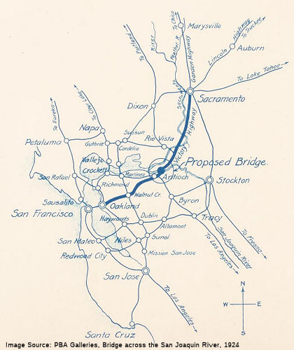 This route was selected by the Victory Highway Association as part of its route from Sacramento to
San Francisco by the 1926 opening of the Antioch-Sherman Bridge, in spite
of the twelve miles of poor road S of Rio Vista and the two ferries
existing at Three-Mile Slough and at Antioch-Sherman.
This route was selected by the Victory Highway Association as part of its route from Sacramento to
San Francisco by the 1926 opening of the Antioch-Sherman Bridge, in spite
of the twelve miles of poor road S of Rio Vista and the two ferries
existing at Three-Mile Slough and at Antioch-Sherman.
(Source: Email from Joel Windmiller, 2/4/2023; Image source: PBA Galleries)
 Portions of this route appear to be part of the National Pony Express Trail, notably between Fish Ranch Road and I-680, although
portions veer off the present route.
Portions of this route appear to be part of the National Pony Express Trail, notably between Fish Ranch Road and I-680, although
portions veer off the present route.
 Statistics
Overall statistics for Route 24:
 Exit Information
 Other WWW Links
 Freeway
[SHC 253.1] Entire route. Only (1) is constructed to freeway standards.
 Pre-1964 Legislative Route
The route that was to become LRN 24 was initially defined in the 1909 First Bond Act as running "From [LRN 4] near Lodi to San Andreas". It was affected by the 1911 definition of the "Alpine State Highway" (Chapter 468), which was defined as:
"The certain road commencing at the Calaveras big tree grove located in Calaveras County thence running to Dorrington in said county, thence E-ly following what is known as the Big Tree and Carson Valley Turnpike to Mt. Bullion in Alpine Cty, thence along county road to Markleeville in Alpine Cty, thence along that certain road via Kirkwood, Silver Lake, Pine Grove and Irishtown to Jackson in Amador Cty, including therewith the road from Picketts in Hope Valley connecting with the Lake Tahoe Wagon Road, a state highway, at Osgood's Place in El Dorado Cty, and the road from Mt Bullion via Loupe in Alpine Cty to Junction in Mono County connecting with the Sonora and Mono State Highway is hereby declared and established a state highway and shall be designated and known as "Alpine State Highway""
For LRN 24, this added the segment between Calaveras Big Trees and Route 89.
It was further extended in 1924 from Route 49 near Angels Camp to Calaveras Big Trees, by Chapter 375, which stated “That certain county road in Calaveras County commencing at a point where such highway connects with the Mother Lode State Highway at Angels Camp, extending through Vallecita and Murphy and connecting with the Alpine State Highway at Calaveras Big Trees in the national forest is hereby declared to be a state highway...” Legislation in 1933 extended it further, adding a segment from "[LRN 23] near Woodfords to the California-Nevada state line". Thus, by 1935 when the route was codified, the definition was:
In 1957, Chapter 36 deleted the reference to Vallecita. Signage on the route was as follows:
This segment was signed as Route 12 from US 99 (LRN 4) to San Andreas, where it joined Route 49 (LRN 65).
This segment started at Route 49 (LRN 65). It was signed as Route 4, and ran to Route 89 (LRN 23) near Markleeville.
This segment began at Woodfords, where Route 88 splits off to the NE from Route 89 and continues to the Nevada state line. It was originally co-signed as Route 4/Route 88, but was Route 88 after 1964.
© 1996-2024 Daniel P. Faigin.
Maintained by: Daniel P. Faigin
<webmaster@cahighways.org>.
 Route 23
 Route 25