
 California Highways:
 This page contains answers to questions I commonly receive via Email that are not covered elsewhere in the site:.
Where can I get a state highway map of California?
Caltrans provides a variety of publications: procurement publications, construction publications, MUTCD publications, cultural publications, and related manuals. However, they no longer seem to publish state highway maps.
How Do I Get Pictures of Highways in California?
Well, there are quite a few of the hobbyist web pages that contain pictures. You would need to contact the photographer to obtain a reuse release.
As for professional (non-hobbyist) pages: There are some good online sources for images, including images in the public domain. In the case of some of the larger ones, like the California State Library and the Library of Congress HABS/HAER collections, you can search the database of images by keyword and then download the images. Always check with the source before using an image to determine whether or not it is protected by copyright.
The Auto Club of Southern CA Digital Archive
http://digitallibrary.usc.edu/search/controller/collection/acsc-m1251.html
The State Library Picture Catalog
http://www.lib.state.ca.us/
The Bancroft Library's California Heritage Collection
http://bancroft.berkeley.edu/collections/calheritage.html
Santa Monica Public Library Image Collection
http://www.smpl.org/depts/ref/image_archives/index.htm
Sacramento History Online (includes sections on autos etc.)
http://www.sachistoryonline.org/
Santa Clarita Valley History in Pictures
http://www.scvhistory.com/scvhistory/scvhistory.htm
The Library of Congress HABS/HAER collection
http://memory.loc.gov/ammem/hhhtml/hhhome.html
Berkeley NISEE has also put up some general bridge pages (not
limited to CA, but many CA bridges are there)
http://nisee.berkeley.edu/godden/
The Caltrans Transportation Library and History Center also has a collection of photographs; most of the photographs in the Caltrans Library's historical archives are protected by copyright. However, under "fair use," you can obtain photographs from the Library's collections for personal or limited scholarly non-profit purposes. Personal use may include framing a photograph and hanging it on your wall. Scholarly use may include reproducing the photograph for a scholarly, not-for profit publication. The Library staff can not take responsibility for selecting pictures for you, but you may schedule a visit to the Library in Sacramento to review the collections. The Library will then pull the negatives, coordinate with a private photography lab and develop one-time materials release agreements if necessary. The requestor must pay the lab directly for duplication and handling of the photos. Since processing print requests is somewhat time-and-labor intensive, the Library may need to limit the number of print requests that can be processed at one time.
If you wish to reproduce photographs in the Library's collections for
any reason other than one-time scholarly use, you need to start with
the public affairs officer (PAO) in the particular Caltrans district
first. If your project is approved, the PAO will then provide a
referral to the Caltrans Library, or to the District photography
people. Once the request is referred by the PAO, the images must be
selected and the process completed as outlined above.
(Thanks to Shirleigh Brannon at the Caltrans
Library for much of the information for this answer.)
Where does the jurisdiction of the CHP start and end?
According to the CHP Office of Public Affairs, the California Highway Patrol has jurisdiction over state and federal highways and over unincorporated county roads. In a few cases, the CHP provides contract traffic enforcement for cities.
When was a particular stretch of highway built?
I don't have this information on the site, although it is easily locatable. For specific information, your best bet is to contact the Public Affairs officer in the Caltrans District that contains the segment of highway. They can check their records.
For a rougher number, the easiest way is to look in the Caltrans Bridge Log. This can be a bit hard to read, but once you know the codes, it's easy to find the information. First, select the Caltrans district containing the highway in question. For example, say you wanted to know when the I-405/I-10 interchange was built. You would select District 7, as this district contains the interchange. Next, you need to know that Caltrans refers to highways using the notation dd-ccc-nnn, where dd is the district, ccc is the county code, and nnn is the highway number. So, in this case, you would look either for 07-LA-010 or 07-LA-405. So, once you found your starting point (in this case, 07-LA-010 on page 9), you page down until you find bridges in the area in question. In this case, it is bridge 53-1628, the 405/10 separation. As the log shows, the bridges in this area were constructed in 1963, so that is the likely date of the interchange.
Note that the log may be incorrect if there has been a natural disaster, or significant construction or widening that involved wholesale bridge replacement. For example, look further in the District 7 log for I-10. You'll see most are 1964, but the La Cienege Bridge is 1994, as is Fairfax/Washington. This is because these structures were replaced due to damage from the 1994 Northridge Earthquake.
I'd like to visit the Caltrans Library in Sacramento? How do I do this?
First, note that while individual researchers are always welcome to schedule a visit, the library is open to the public by appointment only, and it is always a good idea to schedule a visit well in advance. In this era of budget cuts, the library has to focus on its primary mission, which is serving Caltrans and other government agency staff. To schedule an appointment, call 916-654-4601.
When scheduling, note that the library is not open on wekeends. The Library's hours are Monday-Friday, 9 am to 4 pm. The library is located on N between 11th and 12th, next to the State Capitol. The State Library is about two blocks away to the west, and the State Archives is just across the street on O Street between10th and 11th.
Note that much of the information may be available from other sources. For example, many of the items that "history buffs" like to use, such as the Annual and Biennial Reports to the Governor, various Department maps, and the indexes and back issues of California Highways and California Highways and Public Works magazines, are all also available at the State Library as well as other major academic and govermental depository libraries. There is also a significant collection of Department records at the State Archives. The public service desks and reading rooms of the California State Library are open Monday through Friday, 9:30 a.m. to 4:00 p.m., excluding holidays. The Index to California Highways and Public Works from 1937-1967 is available online , and LA Metro has all issues online. Material is also available via Interlibrary Loan.
Do you know how much traffic is on a given highway?
Caltrans provides a traffic count website at http://traffic-counts.dot.ca.gov/. You might also check out http://www.webspawner.com/users/beachbuminda650/index.html. The Caltrans Publications division also has publications that give
traffic statistics; see their page for 1998 and 1999. Here's an article from December 2013 about how to get this information.
(Updated November 2005)
How do I get accident statistics for highways in California?
Start with the Caltrans Office of Transportation Safety. They have a number of publications; they also have a variety of traffic safety information online. Also online is the Annual Collision Data.
What are Class One and Class Two Highways in California?
California does not use these definitions. Those definitions are primarily used back east. The Department uses definitions from the Federal Planning Manual, which was published by the FHWA. Where do the terms come from? It turns out there are functional classification defintitions and access classification definitions. "Class 1" through "Class Five" sometimes appear as access classification schemes at the state DOT level. However, they are not the suggested federal functional classification terms, and Caltrans doesn't appear to use them at all. In fact, it doesn't look like there actually is complete standardization at the state level, although most state DOTs seem to use the FHWA functional classifications in some capacity.
Note that, to complicate things even further, different counties might well use different methods/terminologies for classifying roads and that one should always check with one's local county DOT or dept. of Public Works to determine exactly what their terms mean. For example, Sacramento County doesn't use those terms for classifying their roads.
More information on these terms can be found at the FHWA web site: http://www.fhwa.dot.gov/environment/flex/ch03.htm. There is a Caltrans website which lists the functional classification levels.
Why are announcements of traffic problems called "Sigalerts"?
They are so-named in honor of their inventor, Loyd C. Sigmon, who died in June 2004 at the age of 95. Sigmon devised his traffic alert system in 1955 when he was a co-owner of radio station KMPC and looking for ways to boost its listening audience. When the system debuted, it covered all sorts of emergencies, not just traffic tie-ups. On Labor Day 1955, the first SigAlert was broadcast by six radio stations for a train wreck near Union Station. Other early bulletins included warnings of rabid dogs, a collapsing dam and a ship collision in Los Angeles Harbor. Today, a SigAlert is issued only when one or more lanes of traffic will be blocked for at least half an hour. The term has become so familiar that it was added to the Oxford English Dictionary.
Sigmon based his system on technology used during World War II to monitor German radio broadcasts. He set up a system that enabled police dispatchers to transmit an inaudible radio tone that could be picked up by special SigAlert receivers in local radio stations. The receivers would then tape-record the dispatcher's emergency bulletin and flash a red light and sound a buzzer to alert the radio-station engineer. By pressing a button, the engineer could broadcast the message to listeners in a matter of seconds. Police Chief William Parker named it after Sigmon. SigAlerts "were such attention grabbers that a lot of companies wanted to sponsor them," Sigmon later said. " 'And now, so-and-so presents a SigAlert!' But we had a rule at KMPC against that."
In 1969, the California Highway Patrol took over the monitoring of local freeways from police and assumed responsibility for issuing SigAlerts, which became confined mostly to traffic matters. Sigmon was born in 1909 to a Stigler, Okla., cattle rancher and became fascinated with electronics at a young age. At age 14, he got a ham radio license and first broadcast his nickname, Sig. In 1941, after helping build a radio station in Kansas City, he joined KMPC-AM as an engineer and, after his Army hitch from 1943 to '46, eventually became a partner with Gene Autry in KMPC's parent company, Golden West Broadcasting. With Autry, he also later became a part owner of the California Angels baseball team, his family said.
In addition to overseeing eight radio stations and two TV stations, Sigmon reportedly helped pioneer the helicopter traffic watch in 1960.
Do you know the traffic volume on (insert highway)?
I have some numbers on my site, but they are old. The best place to
start is the Caltrans Traffic Data Branch. They have traffic volumes from 2004 on, as well as truck traffic and ramp volumes.
(Added March 2005, Updated August 2005, Updated
June 2008)
Do you know the laws regarding (insert traffic situation)?
The best place to look is the law itself, which can be found at http://leginfo.legislature.ca.gov/faces/codes.xhtml. What you want to do is to look in the Streets and Highway code or the
Vehicle Code (most likely, the latter).
(Added April 2005)
How can I get a list of all the state highways?
The answer to this depends on what you want it for, and what type of
list you want. If you want information on all the highways in this
state, the site you are on is probably the best place. Just start visiting highways. If you want a simple list of what the highways are as defined by the legislative code, you can go to the definition of the state highway routes in the state highway code. However, that include some routes that were never constructed. Wikipedia
purports to have a list, but as of the last review, it was incomplete.
(Added November 2005)
I know a city in California. How do I find the Caltrans district and other information about it?
A good place to start is the Caltrans document Place Names in
California. This document lists, for every place in California,
the county seat, the California road system map number, the status,
the state route number that goes through that place (if there is only
one), the elevation, population, latitude, and longitude. The database
is also online.
(Added November 2005)
I know the name of a highway. What route is it?
Best place to start is my list of highway names. An alternative reference is the Caltrans document Named Freeways,
Highways, Structures and Other Appurtenances In California.
(Added November 2005)
Do you know the speed limit of (insert road here)?
It depends where the road is:
Can I order my own street sign?
Yes. Street signs can be ordered from USA Traffic Signs. They are a national supplier of road and traffic signs, street signs, sign posts, custom signs, parking signs, and more.
How do I get a sign referring to my (insert noun) on a state highway?
![[LogoSign]](images/logosign.gif) Well, your answer depends on
the type of sign. The Business Logo Sign Program (enabled by 1992 AB 1257) is designed to direct motorists not familiar with an area to "FUEL", "FOOD",
"LODGING", and "CAMPING" services at or near rural freeway
interchanges. They have signs with business logos like the image to
the right. There are various regulations and fees, and you can find
more information at the Caltrans site.
Well, your answer depends on
the type of sign. The Business Logo Sign Program (enabled by 1992 AB 1257) is designed to direct motorists not familiar with an area to "FUEL", "FOOD",
"LODGING", and "CAMPING" services at or near rural freeway
interchanges. They have signs with business logos like the image to
the right. There are various regulations and fees, and you can find
more information at the Caltrans site.
![[TOD Sign]](images/todsign.gif) Another program is the Tourist
Oriented Directional Signs (TODS) Program. This program (enabled by
1994 AB 2339) guides "out-of-town" travelers to California's tourist
attractions. The signs are more generic, and there are restrictions on
the types of businesses (they must be tourist-oriented). There are
also restrictions on where these signs can be placed, for example,
they cannot go on freeways or within cities. The sign is
illustrated to the right. For more information on this program, go to
the Caltrans TODS page.
Another program is the Tourist
Oriented Directional Signs (TODS) Program. This program (enabled by
1994 AB 2339) guides "out-of-town" travelers to California's tourist
attractions. The signs are more generic, and there are restrictions on
the types of businesses (they must be tourist-oriented). There are
also restrictions on where these signs can be placed, for example,
they cannot go on freeways or within cities. The sign is
illustrated to the right. For more information on this program, go to
the Caltrans TODS page.
There are a number of other types of signs put up by the Signs and Work Zones Branch, including Bond Signs, Victims Memorial Markers. You might use their contact list to get a guide sign, but the best place to start is your local district office. If they cannot answer questions, they will refer you to the appropriate person. Note that if you are looking for a sign for your educational institution, you have to meet certain requirements per the California MUTCD, Section 2D.34 (see Page 2D-16). It refers to Table 2D-104(CA) on page 2D-85. For Post Secondary School, Public or Private, specific criteria requires single campus location enrollment of 1,000 students and notes #5 and #6 give additional criteria about definition of student (full- or part-time); and, funding of the sign by private sources.
Sections of your site refer to Chapter such and such. What does this mean?
"Chapter" refers to chapters of the legislative resolutions or statues for a particular year. You can find all of them at http://www.leginfo.ca.gov/statute.html.
How do I get information on an accident that occured on a state highway in California?
One reader of this site recommended the site "Find My Accident", which might be useful. You might also try contacting the CHP or local police department.
How do I get a section of highway named after somone?
Naming of bridges or short segments of highways is typically done by an assembly concurrent resolution or a senate concurrent resolution, so you should contact your state assemblycritter or senator's office. I'm personally not a big fan of these, for a number of reasons. First, there are so many of these nowadays that they lose their meaning -- imagine how many little segments and bridges would have different names if we remembered *every* fallen law enforcement officer, first responder, and soldier.* Drivers just see the names; they don't know the stories behind the names. In many ways, it devalues their stories to only remember the names. I also see lots of resolutions where they list all the family left behind, and provide the hero's birthday (full), birthplace, and family member's names. To me (I work in computer security professionally), that's inviting identity theft risks for the family -- not something the hero would want.
(*: I believe my site is the only one that actually captures the information from those resolutions and preserves the stories -- after editing out potential identity theft fodder. Most people don't know to look here.)
The best way to remember your loved one's legacy is to pass it on through your life's example. Demonstrate their bravery, honor, and ethics by how you live, and pass that on to their family and friends. To say, "I'm behaving this way because (insert name) was my role model is a better legacy than any bridge or highway".
Still, I understand the desire to memorialize -- again, the best place to start is your assemblyman/assemblywoman or your state senator. You can find their office at http://www.legislature.ca.gov/legislators_and_districts/legislators/your_legislator.html
I'm sorry, but I do not accept advertising, either on my main highway site (cahighways.org) or on my blog (blog.cahighways.org).How can I determine where a postmile is on a state highway, or map it to an actual mile?
Try visiting the Postmile Services Postmile Query Tool from Caltrans. The Postmile Query Tool enables you to explore California's Linear Reference System, converting between postmiles, state odometers and geo-coordinates.
There are two places to start (in addition to this site, where you
can go to the page on the particular highway). As I noted in Question
4, Caltrans maintains the Caltrans Bridge Log. This can be a bit hard to read, but once you know the codes, it's easy to find the information. First, select the
Caltrans district containing the highway in question. For example, say
you wanted to know when about I-405/I-10 interchange. You would select
District 7, as this district contains the interchange. Next, you need
to know that Caltrans refers to highways using the notation dd-ccc-nnn,
where dd is the district, ccc is the county code, and
nnn is the highway number. So, in this case, you would look
either for 07-LA-010 or 07-LA-405. So, once you found your starting
point (in this case, 07-LA-010 on page 9), you page down until you
find bridges in the area in question. In this case, it is bridge
53-1628, the 405/10 separation. As the log shows, the bridges in this
area were constructed in 1963. The next site is UglyBridges, which provides access to the National Bridge Log. Bring up the map of California, and drill down to the bridge you want. There you can find all sorts of information on any bridge in the county.
(Added September 2017, based on a
question from David Walker)
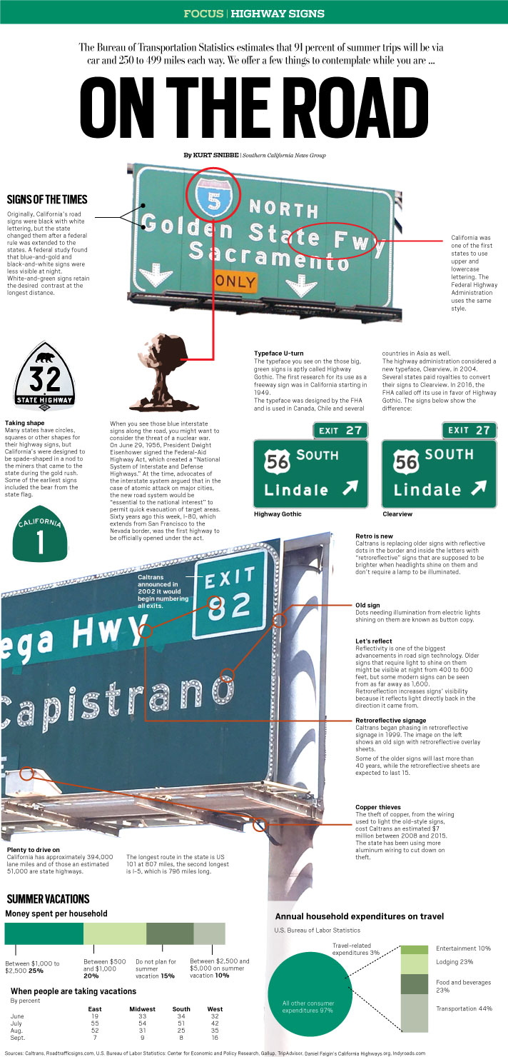
Kurt Snibble of the Orange County Register developed a great explanation. You can find the article here, with a copy here. He also developed the following infographic:
Here are few links from Caltrans’ main web site:
Caltrans acknowledges roadside memorials and their importance to
family members and friends. However, after an appropriate time, these
memorials are removed from the state right of way. Their removal has
more to do with a need to access a particular location to perform
maintenance or construction activities. The memorials/items would be
held at the nearest Caltrans maintenance facility if there is a wish
for the family to retrieve them. Typically, Caltrans requires an
encroachment permit for anything to be placed in the right of way.
Caltrans also would remove any memorial causing a distraction to
motorists.
(Source: SB Noozhawk, 6/17/2018)
Although this is a highways site, I don't typically add links to anything related to driving -- be that accident prevention, accident response, touring information, driving tips, etc. I want the focus of this site to be highways and highway systems, and their history. This isn't a travel or driving site. Further, this is a question I often get from law firms, and it is often a backdoor way of getting advertising. Especially if this comes from a commercial firm, I don't want to be in the position of endorsing something I don't know personally. So the general answer is: No, I will not add the link.
No. All blog entries are written by me. I do not accept material from outside authors. I do not accept sponsorship of posts for placement of links. I do not accept advertising.
First and foremost, this blog has been in existence for a long time. If I went back and updated every old post, I wouldn't have time for anything else. So I do not update anything older than six months. If your comment is about a post older than six months -- sorry, I'm not updating it. In the last six months? I'm not adding new references, but will consider corrections.
Please let me know about it. Send it to me at webmaster@cahighways.org.
 Return to California Highways Home Page
  Start Visiting Highways
© 1996-2020 Daniel P.
Faigin.
Maintained by: Daniel P. Faigin <webmaster@cahighways.org>.