
 California Highways:
Click here for a key to the symbols used. An explanation of acronyms may be found at the bottom of the page.
 Routing
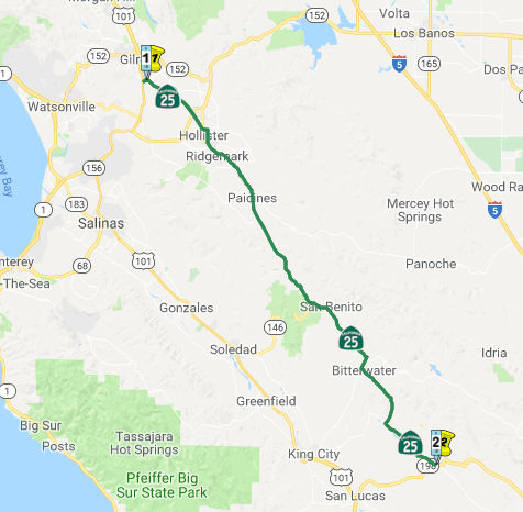 (a) From Route 198 to Route 101 near Gilroy.
(b) (1) Upon a determination by the commission that it is in the best interests of the state to do so, the commission may, upon terms and conditions approved by it, relinquish to the City of Hollister the portion of Route 25 that is located within the city’s jurisdiction between Sunnyslope Road and San Felipe Road prior to the relocation of that portion of Route 25 through adoption of the proposed new easterly bypass alignment of Route 25, if the department and the city enter into an agreement providing for that relinquishment.
(2) The terms and conditions imposed pursuant to paragraph (1) shall include a requirement for the City of Hollister to maintain within its jurisdiction signs directing motorists to the continuation of Route 25 until such time as the new easterly bypass alignment is adopted and opens to traffic.
(3) A relinquishment under this subdivision shall become effective immediately following the recording by the county recorder of the relinquishment resolution containing the commission’s approval of the terms and conditions of the relinquishment.
(4) On and after the effective date of the relinquishment, both of the following shall apply:
(A) The relinquished former portion of Route 25 shall cease to be a state highway.
(B) The relinquished former portion of Route 25 may not be considered for future adoption under Section 81.
(5) Upon a determination by the commission that it is in the best interests of the state to do so, the commission shall, upon terms and conditions approved by it, adopt into the state highway system the proposed easterly bypass alignment for Route 25 that is located between Sunnyslope Road and San Felipe Road in the City of Hollister. The adoption may occur at any time after the effective date of the relinquishment pursuant to paragraph (3).
In January 2014, the CTC authorized relinquishment of right of way in the city of Hollister on Route 25 (Tres Pinos Road, Nash Road, San Benito Street, and San Felipe Road) between Sunnyslope Road and Bolsa Road, under terms and conditions stated in the letter dated December 18, 2013, determined to be in the best interests of the State. Authorized by Chapter 523, Statutes of 2013, which amended Section 325 of the Streets and Highways Code.
 Post 1964 Signage History
In 1963, this route was defined to run "from Route 198 to Route 180 near Paicines", as Route 25 north of County Sign Route J1/Panoche Road was reassigned as Route 180.
In 1984, the route was divided into two segments, "(a) Route 198 to Route 156 in Hollister. (b) Route 156 in Hollister to Route 101 near Gilroy." The portion from Route 25 in Paicines to Route 101 near Gilroy was transferred from Route 180. Originally, Route 180 was to have been much longer, and would have continued from its present terminus to Route 5, and had a segment from Route 5 to Route 25, and the Route 180 would have continued on into Gilroy. This routing for Route 180 was deleted in 1984. There is some discussion of Route 180 being signed as Route 25 (and vice-versa) on the Route 180 pages.
In 2001, the discontinuity in Hollister was removed by SB 290, Chapter 825, 10/12/2001.
In 2013, SB 788 (Chapter 525, 10/9/13) added the language permitting relinquishment to the City of Hollister of the portion of Route 25 that is located within the city’s jurisdiction between Sunnyslope Road and San Felipe Road prior to the relocation of that portion of Route 25 through adoption of the proposed new easterly bypass alignment of Route 25.
 Pre 1964 Signage History
This segment was originally LRN 119, and had the same routing. It was defined in 1933. In 1934, Route 25 was signed along the route from Jct. Route 198 near Priest Valley to Jct. US 101 near Gilroy, via Hollister.
LRN 119/Sign Route 25 reached Sign Route 198/LRN 10 via Lewis Creek Road.
Even by the standards of the 1930s, the route over Lewis Creek Road was
extremely haggard as it forced traffic over numerous earthen fords of
Lewis Creek. At the time the much gentler grade via Peach Tree Road
through Lonoak and Peach Tree Valley but was available but for unknown
reasons it wasn't adopted by the Division of Highways. Lewis Creek
essentially acts as the Monterey/San Benito County Line. Route 25/LRN 119
terminating at Route 198/LRN 10 can be seen on the 1935 Division of
Highways Maps of San Benito County and Monterey County. The switch from
the Lewis Creek Road alignment to the modern route of Route 25 on Peach
Tree Road can be seen on the 1955 and 1956 Division of Highways State
Maps. None of the California Highways and Public Works Guides from the
1950s state why Route 25 was moved from Lewis Creek Road to Peach Tree
Road. It appears that floods in December of 1955 caused numerous washouts
along Route 25/LRN 119 and Route 198/LRN 10. These floods and washouts
likely rendered Lewis Creek Road unusable as State Highway given that it
traversed numerous earthen fords. Route 25/LRN 119 on Peach Tree Road is
next referenced in the November/December 1956 California Highways and
Public Works Guide as being budgeted for paving operations in 1957-58.
(Source: Gribblenation Blog (Tom Fearer): "California_State_Route 25; the Airline Highway")
During the 1964 State Highway Renumbering, Route 25 north of County Sign Route J1/Panoche Road was reassigned as Route 180. This change was made in
anticipation of Route 180 being built across the Diablo Range.
(Source: Gribblenation Blog (Tom Fearer): "California_State_Route 25; the Airline Highway")
 Status
Route 198 to Pinnacles National Park
State Route 25 Curve Restoration Project (SBT 18.8/19.1)
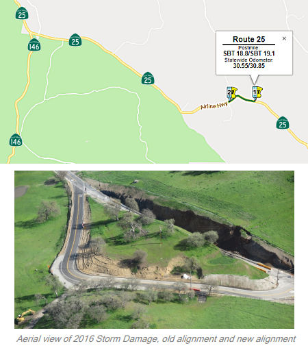 In March 2016, it was reported that a cave-in of a $2.1 million realignment
of Route 25 could keep the new portion of the road closed for two years.
The plan was to address safety issues along Airline Highway/Route 25
(officially part of the State Highway Scenic System), just below the Route 146 entrance into Pinnacles National Park (approx SBT 21.159), at a hard
left turn that a five-year Highway Patrol study supposedly identified as a
site of numerous fatal crashes. When Caltrans began designing a cut across
land that was the designated habitat of the California Tiger Salamander,
as well as numerous blue oaks, the agency was determined to do the job to
protect human lives while doing as little damage to wildlife habitat as
possible. A few months later, the new road is closed, and could stay that
way for two years or more; the old road is now the new road again; and the
California Tiger Salamander will surely lose more of its habitat. After
Caltrans engineers designed the new, flatter, slower turn, the $2.1
million contract went to the John Madonna and Company out of San Luis
Obispo. The construction company followed Caltrans’ engineering plan
to the letter. The only problem was those plans were wrong regarding soil
conditions, and soon after the road was completed in December 2015, the
slopes began to give way and landslides continually blocked the new road.
Caltrans has since instituted an emergency project to open up the old
highway again and the old alignment.
In March 2016, it was reported that a cave-in of a $2.1 million realignment
of Route 25 could keep the new portion of the road closed for two years.
The plan was to address safety issues along Airline Highway/Route 25
(officially part of the State Highway Scenic System), just below the Route 146 entrance into Pinnacles National Park (approx SBT 21.159), at a hard
left turn that a five-year Highway Patrol study supposedly identified as a
site of numerous fatal crashes. When Caltrans began designing a cut across
land that was the designated habitat of the California Tiger Salamander,
as well as numerous blue oaks, the agency was determined to do the job to
protect human lives while doing as little damage to wildlife habitat as
possible. A few months later, the new road is closed, and could stay that
way for two years or more; the old road is now the new road again; and the
California Tiger Salamander will surely lose more of its habitat. After
Caltrans engineers designed the new, flatter, slower turn, the $2.1
million contract went to the John Madonna and Company out of San Luis
Obispo. The construction company followed Caltrans’ engineering plan
to the letter. The only problem was those plans were wrong regarding soil
conditions, and soon after the road was completed in December 2015, the
slopes began to give way and landslides continually blocked the new road.
Caltrans has since instituted an emergency project to open up the old
highway again and the old alignment.
(Source: BenitoLink, 3/30/2016)
In August 2017, the CTC approved the following SHOPP addition: 05-SBt-25 18.8/19.1 Route 25: Near Pinnacles National Park, from 0.7 miles north of San Benito Lateral/Old Hernandez Road to 2.4 miles south of Route 146. Improve curve and flatten slope. $363K (R/W) $4,265K (C) $4,788K (Support) PA&ED: 11/13/2018 R/W: 02/19/2020 RTL: 04/06/2020 BC: 10/28/2020. The project was also included in the final adopted 2018 SHOPP in March 2018.
In February 2019, it was reported that Caltrans is
gearing up to repair a rerouted portion of Route 25 that collapsed in
2016. The agency expects the new work to be completed by the end of 2022.
The State Route 25 Curve Restoration Project has an
estimated cost of $9.5 million and is funded through the State Highway
Operations and Protection Program. This is the second attempt to remove a
dangerous curve in Route 25 in South County. Caltrans previously
contracted out work to remove the curve and cut through a hill turned to
San Luis Obispo-based John Madonna Company for $2.1 million. Work was
completed in 2015, but after three months both sides of the road collapsed
from winter storms. That forced the highway to be rerouted back to its
previous alignment. The straighter route has been closed since. According
to Caltrans, the project will attempt to restore the straight route and
remove the old alignment, along with temporary signals and stop signs. The
project’s environmental impact on flora and fauna still needs to be
considered as Caltrans goes about fixing the road for a second time. The
original design for the reroute called for steep-cut slopes to minimize
oak tree removal, protect vulnerable California Tiger Salamander habitat
and limit land acquisition. Caltrans must complete a yearlong
environmental study, after which a new reroute design is expected in
December 2021. Construction could commence by March 2022, with the road
scheduled to reopen in November 2022.
(Source: BenitoLink, 2/13/2019; Rte25
Curve Restoration Project Fact Sheet)
In March 2019, it was reported that, at a March
community input meeting, Caltrans indicated that the project cost was
increasing 18.95 percent, from the previously reported $9.5 million to
$11.3 million; they also learned that engineering plans were already drawn
up. The severe grade of the original cut through a hillside came about
because of habitat concerns for the California Tiger Salamander, a grove
of large oaks, and a Native American site which federal law prevents
Caltrans from publicly identifying out of concern for theft or vandalism.
For the new project, environmental studies must be completed, and there is
the need to determine the future of a “cultural resource” or
Native American site. There are two curve restoration project designs. One
had a gentler slope than the present cut, leaving much of the hill still
intact. The second was flat, totally removing the hill and whatever may be
buried there. The second design could only be used if the cultural
resource was exempt from protection. Caltrans engineers designed the
original hillside cut and contracted the work out to John Madonna
Construction in San Luis Obispo. The cut hill collapsed a few months after
it was completed, at which point Caltrans rerouted traffic around the hill
along the same path of the original road. According to rancher Steve
Taylor, Madonna told him and others that the design was bad, the two
slopes were unstable, and that Caltrans would not listen to him. During
the March 18 meeting, both Rider and engineer Steve McDonald said the
collapse was Caltrans’ fault because engineers did not take deep
enough core samples and assumed the hill was made up of similar rock as
nearby hills.
(Source: BenitoLink, 3/20/2019)
In May 2019, the CTC approved the following SHOPP
Amendment: 05-SBt-25 18.8/19.1. PPNO 2697. ProjID 0516000164. Route 25
Near Pinnacles National Park, from 0.7 miles north of San Benito
Lateral/Old Hernandez Road to 2.4 miles south of Route 146. Improve curve
and flatten slope. Update total est. cost to $11,301K and completion to
FY20-21. Note: Geotechincal investigations determined flatter slopes than
previously assumed would be required. This results in additional impacts
to culturally sensitive areas delaying the schedule to perform additional
cultural studies. PS&E and R/W support are in current year so a Time
Extension to Allocate will be submitted for approval in the June 2019 CTC
meeting. Construction capital increase is due to additional earthwork not
in original estimate.
(Source: May 2019 CTC Agenda Item 2.1a.(1) Amend
Item 48)
In September 2019, it was reported that repairs to an
800-foot stretch of Route 25 just five miles south of Pinnacles National
Park have been delayed until at least 2022, according to Caltrans Project
Manager Brandy Rider. The delay is primarily because of a Native American
site detected near the project. According to Caltrans, “A variety of
field tests must be conducted, meetings in the field with Native American
partners to better understand the nature of the site, and an eligibility
determination can often take 12 to 24 months.” Additionally, the
California Office of Historic Preservation requires Caltrans to coordinate
with its Native American partners.
(Source: BenitoLink 9/13/2019)
The 2020 SHOPP, approved in May 2020, included the
following Collision Reduction item of interest (carried over from the 2018
SHOPP): 05-San Benito-25 PM 18.8/19.2 PPNO 2697 Proj ID 0516000164 EA
1H810. Route 25 near Pinnacles National Park, from 0.7 miles north of San
Benito Lateral/Old Hernandez Road to 2.4 miles south of Route 146. Improve
curve and flatten slope. Programmed in FY21-22, with construction
scheduled to start in December 2022. Total project cost is $14,192K, with
$9,404K being capital (const and right of way) and $4,788K being support
(engineering, environmental, etc.).
(Source: 2020 Approved SHOPP a/o May 2020)
In July 2020, it was reported that Caltrans announced
that it is accepting public comments through Aug. 7 on proposals to
perform restoration work on the original Route 25 Curve Realignment
Project, located 32 miles south of Hollister. This is the second time
Caltrans will attempt to realign the two-lane road. The first attempt in
2015 was to address safety issues at a location where the California
Highway Patrol had identified it as a site where numerous fatal motorcycle
crashes had occurred. The design proved to be too severe and collapsed
onto the new road just three months after completion. After the collapse
from winter storms, the highway had to be rerouted back to its previous
alignment and the straighter route has been closed ever since. Caltrans
representatives subsequently admitted the collapse was the state
agency’s fault because its engineers did not take deep enough core
samples and assumed the hill was composed of similar rock as the nearby
hills. The extreme angle of the cut through the hill was made because of
Caltrans concerns for the California Tiger Salamander habitat, a grove of
blue oaks, and a Native American site. The original $2.1 million price tag
increased to $9.5 million, then jumped to more than $11 million. According
to the Caltrans project announcement, the newest design would
“provide a permanent solution to the failed 2015 realignment project
by flattening the cut slopes to reduce erosion, promote revegetation
regrowth, and prevent repeated slope failure. The horizontal curves and
superelevation (banking of the roadway such that the outside edge of
pavement is higher than the inside edge, allowing a vehicle to travel
through a curve more safely) will allow speeds up to 51 miles per hour.
The project will also improve access to private driveways within the
project limits.” The announcement also stated the project includes
additional tree planting to replace blue oaks that were removed for the
2015 project. After examining the area, the California Office of
Historical Preservation determined the Native American site was found to
be eligible for protection as a historical property. The design was
changed to move the road toward the north. There will still be a curve,
but not as pronounced as before. Caltrans confirmed that it was not a
burial site and that archeologists examined it without removing any
artifacts.
(Source: Benito Link, 7/5/2020)
In December 2020, the CTC approved for future
consideration of funding the following project for which a Mitigated
Negative Declaration (MND) has been completed: Route 25 in San Benito
County (05-SBt-25, PM 18.8/19.2). Construct two 12-foot lanes with
4-foot outside shoulders and flatten cut slopes to restore curve alignment
on Route 25 in San Benito County. (PPNO 2697) This project is located on
Route 25 from post miles 18.8-19.2 in San Benito County. The Department
proposes to provide a permanent solution to a substantial cut slope
failure on the completed Route 25 Curve Realignment Project. The purpose
of the project was to reduce a higher than average number of collisions by
straightening a curve by cutting through a hillside and realigning the
roadway. The proposed project will repair the failed cut slopes on both
sides of Route 25 by flattening the slopes. This project is fully funded
and is currently programmed in the 2020 SHOPP for a total of $14,192,000
which includes Construction (capital and support) and Right of Way
(capital and support). Construction is estimated to begin December 2022.
The scope, as described for the preferred alternative, is consistent with
the project scope programmed by the Commission in the 2020 SHOPP.
(Source: December 2020 CTC Agenda, Agenda Item
2.2c.(1))
In December 2020, the CTC approved the following SHOPP
Support Phase allocation: $1,756,000 for PS&E and $385,000 ($345,000
programmed) for R/W Sup for 05-SBt-25 PM 18.8/19.2. PPNO 05-2697 ProjID
0516000164 EA 1H810. Route 25 Near Pinnacles National Park, from 0.7 miles
north of San Benito Lateral/Old Hernandez Road to 2.4 miles south of Route 146. Improve curve and flatten slope. (Concurrent consideration of funding
under Resolution E-20-118; December 2020.)
(Source: December 2020 CTC Agenda, Agenda Item
2.5b.(2a) #16)
In December 2021, there was an update on the status of
this project: This $4.3 million project will correct a 2015 alignment that
resulted in slope failure on both sides of the highway. Construction will
take place north of the San Benito Lateral, near where Old Hernandez Road
intersects with ROute 25. According to the COG December report, the
project is on schedule with right-of-way certification scheduled for May
19, 2022. A stump-and-cut contract to clear the construction area will be
available for bids in fall 2022.
(Source: BenitoLink, 12/8/2021)
In October 2022, the CTC approved, for future
consideration of funding, State Route 25 Curve Alignment Restoration
Project (05-SBt-25, PM 18.8/19.2). Construct two 12-foot lanes with
4-foot outside shoulders and flatten cut slopes to restore curve alignment
on Route 25 in San Benito County. This project is located on Route 25
between post mile 18.8 and 19.2, in San Benito County. The Department
proposes to provide a permanent solution to a substantial cut-slope
failure on the completed Route 25 Curve Realignment Project. The purpose
of the project is to reduce a higher than average number of collisions by
straightening a curve by cutting through a hillside and realigning the
roadway. The proposed project will repair the failed cut-slopes on both
sides of Route 25 by flattening the slopes. The CTC then amended
this project in the SHOPP: 05-SBt-25 18.8/19.2. PPNO 05-2697; ProjID
0516000164; EA 1H810. Route 25 Near Pinnacles National Park, from 0.7
miles north of San Benito Lateral/Old Hernandez Road to 2.4 miles south of
Route 146. Improve curve and flatten slope. Allocation Changes ($ ×
1,000): Const Cap: $8,672 ⇨ $6,831; Total $14,192 ⇨ $12,351.
Note: Split landscape mitigation plant establishment work into project EA
1H811/PPNO 05-2697Y from parent project EA 1H810/PPNO 05-2697.
(Source: October 2022 CTC Agenda, Agenda Item
2.2c.(4), October 2022 CTC Agenda, Agenda Item 2.1a.(1d) #24)
In October 2022, the CTC approved the following
construction phase allocation: $9,912,000. 05-SBt-25 18.8/19.2. PPNO
05-2697; ProjID 0516000164; EA 1H810. Route 25 Near Pinnacles National
Park, from 0.7 miles north of San Benito Lateral/Old Hernandez Road to 2.4
miles south of Route 146. Outcome/Output: Improve curve and
flatten slope to improve safety. This project will reduce the number
and severity of collisions. Programmed allocation: CON ENG $1,506,000;
CONST $6,831,000. CEQA - MND, 9/30/2020; Re-validation 6/3/2022. NEPA -
CE, 9/14/2020; Re-validation 6/3/2022. Future consideration of funding
approved under Resolution E-20-118; December 2020. Four month time
extension for CONST and CON ENG approved under Waiver 22-115; August 2022.
Concurrent Amendment under SHOPP Amendment 22H-004; October 2022.
(Source: October 2022 CTC Agenda, Agenda Item
2.5b.(1) #12)
In July 2023, it was reported that according to the
Caltrans website, restoration began in January and is due to be completed
Jan. 4, 2024. Caltrans is saying it will be done in early spring 2024. As
of early July 2023, however, the work that seems to have been done is
removal of the blue oaks atop the hill, an orange environmental barrier,
and barbed wire along the southern side of the hill. According to
Caltrans, $500,000 had been spent on the project following the collapse.
Caltrans had a budget of $2.1 million in the original project to realign
that section of Route 25. Caltrans has indicated that biological
preconstruction survey work is in progress before the dirt moving starts
in late July to early August. An initial study with “mitigated
negative declaration” was prepared for the project. Caltrans
indicates that the blue oaks will be restored at a 10:1 ratio and require
a three-year plant establishment period. The budget for the project, from
the SHOPP, is close to $14.4 million, when landscape mitigation plans are
included (this is from the October 2022 CTC Agenda Item, the total
projected cost before the landscape mitigation was split out).
(Source: BenitoLink, 7/25/2023)
Pinnacles National Park to the S limits of Hollister
In March 2017, the CTC approved for future consideration of funding a project located near Hollister in San Benito County (well, not really, 05-SBt-25, PM 25.9/26.3, which puts it between Pinnacle National Park and Paicines) proposes to correct deficiencies on Route 25. To improve safety and reduce collisions, the proposed project will correct deficiencies in the non-standard curve radius, realign the highway, widen shoulders, construct rumble strips and extend one culvert. This project is programmed in the 2016 SHOPP for $7,069,000 in Construction (capital and support) and Right of Way (capital and support). Construction is estimated to beginning in Fiscal Year 2017-18. The scope, as described for the preferred alternative, is consistent with the project scope programmed by the Commission in the 2016 State Highway Operation and Protection Program.
In October 2013, the CTC considered for future approval of funding a project in San Benito County that will realign and straighten a portion of Route 25 near the town of Paicines (approx SBT 39.496). The project is programmed in the 2012 State Highway Operation and Protection Program. The total estimated cost is $4,205,000 for capital and support. Construction is estimated to begin in Fiscal Year 2014-15. The scope, as described for the preferred alternative, is consistent with the project scope programmed by the Commission in the 2012 State Highway Operation and Protection Program.
Hollister Bypass
![[Hollister Bypass]](maps/025-hollister.jpg) This project constructed a 2.7 mil urban arterial with 6 lanes from Sunnyslope
Road (approx SBT R49.918) to East Park Street, and a 4 lanes from East
Park Street to Bolsa Road. It included grading, paving, traffic signals,
bike lanes, signing, striping, and sound walls. The total cost was $43.3
million. Environmental work started in December 2004, and the project was
opened in November 2008.
This project constructed a 2.7 mil urban arterial with 6 lanes from Sunnyslope
Road (approx SBT R49.918) to East Park Street, and a 4 lanes from East
Park Street to Bolsa Road. It included grading, paving, traffic signals,
bike lanes, signing, striping, and sound walls. The total cost was $43.3
million. Environmental work started in December 2004, and the project was
opened in November 2008.
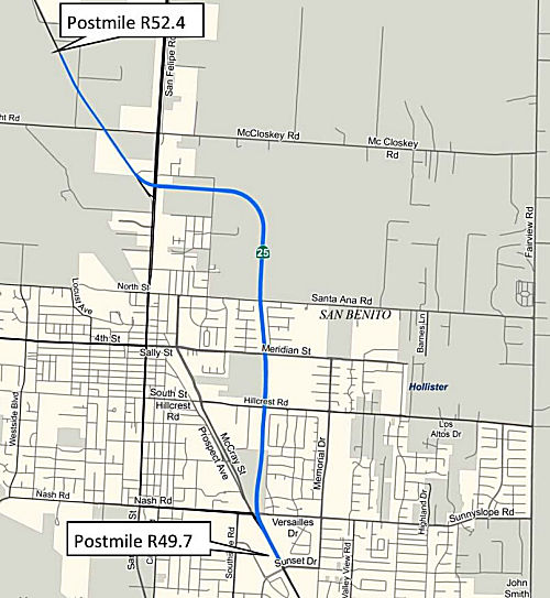
Route 25 Rerouting in Hollister (~ SBT R49.937 to SBT R52.275)
In March 2014, the CTC considered a route adoption in the city of Hollister. The purpose of the route adoption was to restore the connectivity of Route 25 by establishing a new alignment for a portion of Route 25 east of downtown city of Hollister. A portion of Route 25 through the City was relinquished by the California Transportation Commission (Commission) on January 29, 2014. Senate Bill 788, approved by the Governor on October 3, 2013, allowed the relinquishment to precede the bypass route adoption by amending Section 325 of the Streets and Highways Code. Route 25 traverses the entire north-south length of San Benito County.
From the southern county boundary at the junction of Route 198 near King City, Route 25 extends north through the unincorporated communities of Paicines and Tres Pinos, and through the City to the northern county boundary near Gilroy where it connects to US 101. This route is classified as a minor arterial, and it is primarily a rural facility. Within the City, the relinquished portion of Route 25 is a two-lane facility with no shoulders except for a section through downtown Hollister. The one-mile long section along San Benito Street and San Felipe Road between 7th Street and Bolsa Road is four lanes wide and the shoulders are used for parking. Speed limits range from 25 mph to 40 mph and increases to 55 mph when Route 25 connects to Bolsa Road north of downtown.
The City, through the Council of San Benito County Governments (SBtCOG), initiated and built a bypass and requested that the Department adopt the bypass as the new location of Route 25. Additionally, the City desired to control the existing Route 25 within the city limits and accept relinquishment of the route through downtown Hollister (per City Council of City of Hollister Resolution No. 2013-180). In 2006, the Department and SBtCOG entered into a cooperative agreement for the construction of the Route 25 City of Hollister bypass with the intention of transferring it to the Department through a future Transfer of Highway Location Commission action item. The agreement indicated that SBtCOG would design and construct the bypass in accordance with state highway standards, policies and practices.
The route transfer would consist of two actions: 1) the adoption of the newly constructed bypass facility as the new Route 25 and 2) the relinquishment of the existing Route 25 within the city of Hollister to the City. The bypass project construction was completed, and the roadway opened to travel in February 2009. The bypass was constructed as an urban arterial 2.63 miles long with five at-grade intersections. It begins at the intersection of Sunnyslope/Tres Pinos Roads and Airline Highway (Route 25) and extends north as a six-lane facility with signalized intersections at Sunnyslope/Tres Pinos Roads and East Park Street. North of East Park Street, the bypass continues as a four-lane facility with signalized intersections at Hillcrest Road, Meridian Street, and Santa Ana Road. North of Santa Ana Road, the four-lane facility turns westward to intersect with San Felipe Road and connect to the two-lane Bolsa Road (Route 25). The bypass provides an improved level of service and better serves regional traffic than the existing Route 25, which is located in a congested downtown and commercial area.
However, this facility presents a number of deficiencies that do not comply with Department standards. The Route Transfer Report (RTR) approved on April 2, 2012, identified these deficiencies and did not recommend the route transfer until corrective action was taken. The bypass non-standard features included deficiencies with the hydraulic-drainage systems (improper construction of drainage inlets, type of dike used, etc.), roadway geometrics (super-elevation rate is insufficient for the posted speed), storm water management (the project did not comply with the National Pollutant Discharge Elimination System Permit), roadway pavement (longitudinal cracks in the shoulder section and concrete dikes), soundwall (separation along the expansion joints), and signal loops (advance loops at the signals are at the wrong locations).
With the proposal from the Department to program a SHOPP project to address the deficiencies, the City agreed to accept relinquishment of the existing Route 25 within the city limits at no cost to the Department. The City pursued enabling legislation to allow the Commission to approve the relinquishment of Route 25 to the City. In June 2013, the Project Study Report (PSR) was approved to allow the Department to program the SHOPP project and address the deficiencies identified in the RTR. The estimated cost of the project is approximately $ 9,235,000, which includes construction and Right of Way costs escalated to the year of construction. The project is scheduled to begin construction in Fiscal Year 2017-18.
On October 3, 2013, the Governor approved Senate Bill 788, allowing the relinquishment to precede the bypass route adoption by amending Section 325 of the Streets and Highways Code. On January 29, 2014, the Commission approved relinquishment of a portion of Route 25 to the City. The relinquished alignment through downtown Hollister runs along Tres Pinos Road and San Benito Street, to the intersection of San Felipe Road and Bolsa Road (Route 25). The bypass benefits to the state include: a new facility with access control between intersections, no parking allowed, and a striped bike lane within the eight-foot wide shoulder. All bypass intersections are projected to be at Level of Service (LOS) C or better in 2025, with the exception of the intersection at San Felipe Road. It will be at LOS D, but improved from the existing condition of LOS F. In comparison, the relinquished Route 25 route serves local traffic at lower levels of service, allows parking, functions as a minor arterial with multiple access points between intersections, and does not provide for a bike lane. The expected ten-year bypass maintenance cost is comparable to the maintenance cost for the relinquished Route 25. The route adoption has the support of all local agencies. Resolutions requesting the Department to transfer Route 25 to the bypass have been passed by the City, the County of San Benito, and SBtCOG.
 In June 2015, it was reported that Hollister Mayor Ignacio Velazquez was fed
up with the long-running standstill regarding a planned Route 25 widening.
He’s at the point where he’s willing to consider a locally
built alternative if Caltrans doesn’t find a way to get the project
moving soon. Velazquez suggested that building a county road along the
current highway route (with a truck ban), from Hollister to the county
line, might solve the problem. He hoped that local government leaders
could work with Caltrans to widen the two-lane commuter highway, a primary
gateway to and from Hollister where two Hollister men recently died in
vehicle accidents; but he was unsure whether the county could count on
Caltrans to provide the hundreds of millions of dollars needed to
accomplish the widening project, which has been discussed locally for more
than a decade due to safety issues and fatalities. The San Benito COG
expressed some optimism and said there had been “a lot of
progress” on the widening issue in the past six to eight months at
the COG board level. Since September the agency and its board have been
taking steps needed to pursue an amendment to a regional transportation
plan to place Route 25 on a list of constrained projects, viewed as a
necessary precursor to receive significant state funds for the road. The
proposed plan to widen Route 25 to a four lanes from the San Benito County
line to Hollister would cost about $300 million. Santa Clara County is
responsible for the portion of the highway from the San Benito County line
to US 101 and its officials are examining possible solutions for that
section in their plans as well.
In June 2015, it was reported that Hollister Mayor Ignacio Velazquez was fed
up with the long-running standstill regarding a planned Route 25 widening.
He’s at the point where he’s willing to consider a locally
built alternative if Caltrans doesn’t find a way to get the project
moving soon. Velazquez suggested that building a county road along the
current highway route (with a truck ban), from Hollister to the county
line, might solve the problem. He hoped that local government leaders
could work with Caltrans to widen the two-lane commuter highway, a primary
gateway to and from Hollister where two Hollister men recently died in
vehicle accidents; but he was unsure whether the county could count on
Caltrans to provide the hundreds of millions of dollars needed to
accomplish the widening project, which has been discussed locally for more
than a decade due to safety issues and fatalities. The San Benito COG
expressed some optimism and said there had been “a lot of
progress” on the widening issue in the past six to eight months at
the COG board level. Since September the agency and its board have been
taking steps needed to pursue an amendment to a regional transportation
plan to place Route 25 on a list of constrained projects, viewed as a
necessary precursor to receive significant state funds for the road. The
proposed plan to widen Route 25 to a four lanes from the San Benito County
line to Hollister would cost about $300 million. Santa Clara County is
responsible for the portion of the highway from the San Benito County line
to US 101 and its officials are examining possible solutions for that
section in their plans as well.
(Source: Free Lance, 6/23/2015)
In May/June 2019, it was reported that Caltrans
initiated construction on a roadway safety improvement project to correct
the super elevation and widen the existing shoulders along Route 25 from
Sunnyslope/Tres Pinos Rd. to San Felipe Road in Hollister. Caltrans notes
that the state-funded project will improve alignment consistency, traffic
flow, and safety. Improvements will include: constructing a curve
correction, widening shoulders, flattening and seeding embankment slopes,
improving drainage facilities, adding sidewalks and reconstructing curb
ramps, and replacing signal loop detectors. The project is expected to be
complete in December 2019. Specifically, the work between Santa Ana and
Sunset Drive includes the following:
(Source: San Benito Live, 6/6/2019)
Northern End of Hollister to Gilroy/US 101
In April 2022, it was reported that the San Benito County Arts Council
was seeking California-based artists or artist teams to submit their
qualifications to create and install an outdoor sculpture at the corner of
Santa Ana Road and Route 25 in Hollister (~ SBT R51.108). The project is
part of a State Highway Beautification Project, sponsored by the
California Department of Transportation and the Clean California Program.
Launched by Gov. Gavin Newsom as part of his California Comeback Plan,
Clean California is investing $1.1 billion for state and local governments
to clean up trash and debris statewide, and beautify community gateways
and public areas along highways, streets and roads. The local project is
located along Route 25 near the east entrance to Pinnacles National Park.
This bypass route serves as the “main street” through multiple
residential neighborhoods, and retail and industrial developments. The
plan is to install a site-specific outdoor sculpture as part of this
project. The sculptural piece will be installed at the “start”
of this particular Route 25 corridor between Santa Ana and Sunnyslope
Road, and will include aesthetic elements that reflect and enhance
community identity, as well as integrate with the overall goal of this
Caltrans project to beautify the route and encourage pedestrian and
bicycle usage for local residents and visitors. The total public art
budget for this project is $130,000 and is funded through Clean
California.
(Source: SanBenito.Com, 4/21/2022)
Gilroy to Hollister Highway (05-SBt-25, PM 51.5/60.1, 04-SCl-25, PM 0.0/2.6)
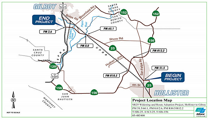 In August 2016, the CTC approved for future consideration of funding the
following project for which a Final Environmental Impact Report (FEIR) has
been completed: Route 25 (05-SBt-25, PM 51.5/60.1, 04-SCl-25, PM 0.0/2.6)
in San Benito and Santa Clara Counties that will select a corridor for
Route 25 near the cities of Hollister and Gilroy. This project in San
Benito and Santa Clara counties is for route adoption only, for portions
of Route 25 near the cities of Hollister and Gilroy. The project is
locally funded for the Project Approval and Environmental Document phase
only for approximately $7,000,000.
In August 2016, the CTC approved for future consideration of funding the
following project for which a Final Environmental Impact Report (FEIR) has
been completed: Route 25 (05-SBt-25, PM 51.5/60.1, 04-SCl-25, PM 0.0/2.6)
in San Benito and Santa Clara Counties that will select a corridor for
Route 25 near the cities of Hollister and Gilroy. This project in San
Benito and Santa Clara counties is for route adoption only, for portions
of Route 25 near the cities of Hollister and Gilroy. The project is
locally funded for the Project Approval and Environmental Document phase
only for approximately $7,000,000.
In October 2016, the CTC approved a resolution to adopt a new corridor for Route 25, to enhance interregional system connectivity and regional traffic operations. This new corridor will run from US 101 to San Felipe Road, where it will connect with the Hollister Bypass approved in 2014. The existing Route 25 will become a frontage road. The route adoption map makes it appear that an intersection with Route 156 will be removed; if the new route is freeway, there could be an interchange there. A California Environmental Quality Act (CEQA) - Environmental Impact Report (EIR), which serves as a planning document, was signed on June 6, 2016. The Project Report recommending the route adoption was approved on July 8, 2016. The approved Project Report scoped constructing Route 25 on a new alignment that will be near parallel to the existing Route 25 alignment. Nearly all of the existing Route 25 conventional highway alignment witihin the project limits will be relinquished upon construction of the four-lane expressway, thereby separating terminal access (farmland, business and residential) trips from interregional trips. Relinquishment of the existing Route 25 would not occur until the pavement is brought to a state of good repair. The Project Report recommending the controlled access highway route adoption was approved on July 8, 2016. The environmental document for the Route Adoption Study was approved at the August 2016 Commission meeting with Resolution E-16-60. Controlled access highway agreements will be executed with the City of Hollister, San Benito and Santa Clara Counties.
In July 2017, Mr. Roadshow noted that the sales tax
approved by Santa Clara County voters last year will pay for new ramps at
the Route 25-US 101 interchange, which some day will be the start of a
four-lane freeway on Route 25 to that would hook north near Route 152 or
Route 156. The current two lanes of Route 152 from US 101 to Casa de Fruta
would likely remain as a frontage road. The cost of this isn’t
known, but it’s not going to be cheap. However, the gas and car fee
hikes approved by Gov. Brown and the state Legislature this year include
$500 million annually for congested corridors and truck routes.
(Source: Mercury News, 7/2/2017)
Note: There is a major project to improve the Route 101/Route 25 corridor. See the detailed discussion with US 101. See below for information on the US 101/Route 25 interchange
 In March 2019, it was reported that instead of just adding two lanes to the existing Route 25 between Hollister and Gilroy,
state officials are proposing the construction of a new four-lane
expressway, using the current two-lane highway as a parallel frontage
road. Caltrans revealed in detailed maps in March 2019 they are proposing
the eventual replacement of 11.2 miles of the existing Route 25 two-lane
highway with a four-lane expressway in San Benito and Santa Clara
counties. The project would ease a big strain on the commuting route for
the more then 12,000 San Benito residents who commute daily on Route 25 to
Santa Clara County. The Route 25 project is a shared responsibility
between state and federal transportation agencies and San Benito County.
The $241 million cost will be shared with Santa Clara County. Traffic
impact fees charged to new construction will pay a portion of the project
cost, up to $88 million. The plan includes a future new interchange at the
Route 25 / Route 156 intersection, would require widening Route 156
between just northwest of Hollister, and would involve the construction of
a new bridge over the Pajaro River. Caltrans is the lead agency for this
project under the California Environmental Quality Act. The Final
Environmental Impact Report (EIR), completed in June 2016 evaluated a
proposed route adoption and includes a route adoption study (a broad Tier
I environmental analysis), according to CalTrans.
In March 2019, it was reported that instead of just adding two lanes to the existing Route 25 between Hollister and Gilroy,
state officials are proposing the construction of a new four-lane
expressway, using the current two-lane highway as a parallel frontage
road. Caltrans revealed in detailed maps in March 2019 they are proposing
the eventual replacement of 11.2 miles of the existing Route 25 two-lane
highway with a four-lane expressway in San Benito and Santa Clara
counties. The project would ease a big strain on the commuting route for
the more then 12,000 San Benito residents who commute daily on Route 25 to
Santa Clara County. The Route 25 project is a shared responsibility
between state and federal transportation agencies and San Benito County.
The $241 million cost will be shared with Santa Clara County. Traffic
impact fees charged to new construction will pay a portion of the project
cost, up to $88 million. The plan includes a future new interchange at the
Route 25 / Route 156 intersection, would require widening Route 156
between just northwest of Hollister, and would involve the construction of
a new bridge over the Pajaro River. Caltrans is the lead agency for this
project under the California Environmental Quality Act. The Final
Environmental Impact Report (EIR), completed in June 2016 evaluated a
proposed route adoption and includes a route adoption study (a broad Tier
I environmental analysis), according to CalTrans.
(Source: SanBenito.Com 3/20/2019; Hollisterto
Gilroy State Route 25 Route Adoption, 05-SBt-25 (PM 51.5/60.1), 04-SCl-25 (PM 0.0/2.6),Final Environmental Impact Report, Volume I of II, June 2016)
According to the 2016 FEIR, both of the route adoption alternatives—Alternatives 1 and 2—are 11.2 miles long and share the same alignment from ½ mile south of Shore Road in San Benito County to US 101 in Santa Clara County. Between ½ mile south of Shore Road and the southern end of the proposed project at San Felipe Road, the two proposed route adoption alternatives separate. Alternative 1 proposes to align the future four-lane expressway generally to the east of the existing highway. Alternative 2 would be aligned mostly to the west of the existing two-lane highway. Both alignments would be wide enough to accommodate a future four-lane expressway. Alternative 1 would be 342 feet wide including the median, but not including the frontage roads on one or both sides. Alternative 2 would be 240 feet wide, including the median, but not including frontage roads. The alignments would also be wide enough to accommodate an interchange near the existing intersection of Route 25 and Route 156 and a replacement Route 25/US 101 interchange north of the existing interchange.
Both route adoption alternatives would accommodate the following in the future:
Alternative 1 would be 342 feet wide including the median, but not including the frontage roads on one or both sides. This alternative would provide Flynn Road with direct access to the expressway. The alignment of Alternative 1 would begin at San Felipe Road and follow the existing alignment of Route 25 to the northern intersection of Briggs Road and Route 25. The new alignment would remain east of the existing route from that point until just past Hudner Lane, where it would cross the existing Route 25. The new alignment would be west of the existing highway for only a short distance before crossing the highway again between Hudner Lane and Shore Road. From that point, the new alignment would stay east of the existing Route 25 until just past Carnadero Creek where it would realign with the existing Route 25 until reaching US 101.
Alternative 2 would be 240 feet wide, including the median, but not including frontage roads. With this alternative, Briggs Road would be extended westward to a T-intersection with the expressway. The median would widen to 86 feet at the unsignalized crossroads (Wright Road, a connector at Grant Line, and the new Bolsa Road intersection) to allow room for large trucks to stop in the middle of the expressway before turning left into the stream of traffic. The alignment of Alternative 2 would begin at San Felipe Road and run west of and parallel to the existing Route 25 before crossing the route south of Shore Road. From that point, the new alignment would be the same as for Alternative 1, remaining east of the existing Route 25 until just past Carnadero Creek where it would realign with the existing Route 25 until reaching US 101. For Alternative 2, some of the proposed frontage roads have been eliminated or reconfigured in response to public comments. In some locations, instead of new frontage roads, 40-foot-wide private access easements are planned to provide access to farm fields. Southeast of the Route 25/Route 156 intersection, the proposed west side frontage road was eliminated; instead, two private access easements are now proposed. A new west side frontage road would have a cul-de-sac south of Hudner Lane instead of extending to McConnell Road, and would run northwestward to a point approximately 1.7 miles south of Shore Road. The segment of the east side frontage road between the Grant Line and Shore Road is no longer proposed; a short private access easement would provide farm field access. North of Shore Road, the east side frontage road would be replaced by private access easements.
Note that the Final EIR selected the Alternative 2 as
the preferred alternative for route adoption. In October 2016, Caltrans
submitted documentation to the California Transportation Commission for
the route adoption of the preferred route adoption alignment, which was
subsequently approved.
(Source: Hollister to Gilroy State Route 25 RouteAdoption,
05-SBt-25 (PM 51.5/60.1), 04-SCl-25 (PM 0.0/2.6),Final Environmental
Impact Report, Volume I of II, June 2016)
In March 2020, it was reported that Caltrans was
implementing a six-month trial beginning at the end of March 2020 that
would prevent left turns from Bolsa Road onto the Route 25 (SCL 0.637)
during the afternoon rush hour. Specifically, the left turn from Bolsa
Road onto Route 25 will be restricted on weekdays from 3-7 p.m. California
Highway Patrol will enforce the new rule and monitor the intersection with
cameras, which will also allow the transit agencies to collect data.
Caltrans has identified the intersection—which motorists use to
circumvent traffic at the US 101/Route 25 onramp—as one of the main
causes for congestion and collisions on Route 25. Designs to rework the
problematic US 101/Route 25 are still being discussed. One of the options
presented in March 2020 prohibits access to southbound US 101 from Route 25. Instead, motorists would be required to get on northbound US 101 and
exit at Monterey Road to take the onramp for southbound US 101. Phase 1
construction is scheduled to begin in summer 2021 and will be funded by
Santa Clara County’s allocation of SB 1 funds. In the meantime,
proposed short-term solutions for the gridlock include constructing an
auxiliary lane between Castro Valley Road and the Route 25 onramp. Costs
vary between $1 million and $2 million. In May 2020, the Mobility
Partnership expects to identify a possible trade corridor route from four
alternatives. Before choosing a route, the partnership needs to define
criteria such as costs, environmental impacts, right of way acquisitions
and a wildlife corridor. One issue that needs to be weighed is whether
it’s worth selecting options closer to San Benito County’s
commercial areas that would connect to Route 25 further into the county.
The more portions of Route 25 the new trade corridor uses, the more funds
(including grants) would be available to fund the widening project.
(Source: BenitoLink, 3/9/2020)
In December 2020, it was reported that the CTC approved
$55 million to complete a $101 million funding package for transforming
the outdated two-lane connector between US 101 and Route 25 in southern
Santa Clara County to a new four-lane connector with shoulders and bike
lanes. The project, set to begin construction in 2022, will improve
traffic flow and decrease backups on US 101.
(Source: The Bay Link, 12/3/2020)
In March 2021, it was reported that the Council of San
Benito County Governments (COG) Board of Directors unanimously approved an
agreement with Caltrans to begin the environmental permit-seeking phase
for the Route 25 widening project. The approval was granted pending legal
counsel’s review of the agreement. The agreement is for the
first phase of the $241 million widening project—expanding the
two-lane highway into a four-lane expressway from San Felipe Road to the
Route 25/Route 156 intersection. The entire project will go to the Santa
Clara County line. It outlines the responsibilities and roles of COG and
Caltrans in regards to the project, which includes the local
transportation agency paying 50% of the estimated $10 million costs for
the environmental work. COG is expected to pay $100,000 as a deposit to
Caltrans for the environmental phase. COG will fund the project through
the county’s Measure G, a 30-year, 1% sales tax increase approved by
voters in November 2018. It’s expected to generate $16 million
annually for a total of $480 million.
(Source: BenitoLink, 3/2/2021)
 In August 2023, it was noted that the adopted Route 25 route proposes an
alignment that is located west of the existing alignment from San Felipe
Road to 0.6 mile north of the proposed Grant Line Road intersection. Just
north of the Grant Line intersection, Route 25 would cross the existing
highway and remain east of it to the end of the route. The existing Route 25 route would serve as a frontage road that would connect to the new
highway near the Grant Line and Bolsa Road intersections. The project also
includes an overpass on the Route 156/Route 25 interchange. Caltrans is
currently constructing a temporary turbo roundabout at the Route 25/156
interchange to address the high incidence of collisions. It was estimated
to cost $10.7 million but Caltrans was recently awarded $13.7 million for
it.
In August 2023, it was noted that the adopted Route 25 route proposes an
alignment that is located west of the existing alignment from San Felipe
Road to 0.6 mile north of the proposed Grant Line Road intersection. Just
north of the Grant Line intersection, Route 25 would cross the existing
highway and remain east of it to the end of the route. The existing Route 25 route would serve as a frontage road that would connect to the new
highway near the Grant Line and Bolsa Road intersections. The project also
includes an overpass on the Route 156/Route 25 interchange. Caltrans is
currently constructing a temporary turbo roundabout at the Route 25/156
interchange to address the high incidence of collisions. It was estimated
to cost $10.7 million but Caltrans was recently awarded $13.7 million for
it.
(Source: BenitoLink, 8/1/2023)
State Route 25 Expressway Conversion (Segment 1) (05-SBt-25 51.5/58.2)
In June 2021, the CTC approved the following SB1/LPP
allocation: $2,500,000. 05-SBt-25 51.5/58.2. PPNO 05-3061; ProjID
0520000007; EA 48541. State Route 25 Expressway Conversion
(Segment 1). San Felipe Road to 0.3 mile north of Hudner 0.8
mile west of Route 25 0.5 mile east of Route 25. Construct interchange and
convert to four-lane expressway. (Concurrent LPP (Formulaic) Programming
Amendment under Resolution LPP-P-2021-15; June 2021) (Contribution of
$2,500,000 local Measure G funds) (The Department request non-proportional
spending.) Allocation: PA&ED $2,500,000.
(Source: June 2021 CTC Agenda, Agenda Item 2.5s.(1)
#2)
Also in June 2021, the CTC approved a request from the
Council of San Benito County Governments to add the following to their
2019 LLP-Formulaic fund allocation. The State Route 25 Expressway
Conversion - State Route 25/156 Interchange Project and program $2,500,000
to Project Approval and Environmental Documentation in Fiscal Year
2020-21. The project will construct a new four-lane expressway from San
Felipe Road in Hollister to Hudner Lane north of State Route 156 in San
Benito County and construct an interchange at Route 25 and Route 156. The
expressway and interchange will replace a two-lane conventional highway
and a roundabout at the highway intersections. The anticipated benefits of
this project include congestion reduction and improved safety.
(Source: June 2021 CTC Agenda, Agenda Item 4.16)
In December 2021, there was an update on the status of
this project: The expansion project will convert the two-lane highway from
San Felipe Road to the Route 25/Route 156 intersection into a four-lane
expressway. In the September report, the estimate for the completion of
the environmental studies was set for fall 2021 on this $241 million
project. With the completion of those studies, work on the project began
Nov. 3 with final planning and analysis of the environmental studies.
(Source: BenitoLink, 12/8/2021)
Safety Improvements (~ SBT R52.33 to SCL 2.413)
There have been a number of changes made to this route to improve safety. In 2000, a dozen people were killed on the flat, two-lane 11-mile stretch between Gilroy and Hollister. By 2003, Caltrans had installed a four-foot median rumble strip flanked by double yellow stripes; widened the shoulders with more rumble strips placed there; banned passing; and set the speed limit at 55 mph. This has made it safer: 97 people on the stretch from 2000 to 2002, 56 have been injured from 2003 to 2006. Crashes have fallen 39%.
The SAFETEA-LU act, enacted in August 2005 as the reauthorization of TEA-21, provided the following expenditures on or near this route:
In 2010, work continued on making Route 25 safer. The first phase of construction included work on the western side of Route 25 and the project area. The primary work that was completed includes paving the western roadway shoulders and construction of private driveway access roads. The second phase of construction included work on the eastern side of Route 25. Phase II work included excavation, grading, and shoulder widening. The net goal is driveway consolidation.
Route 25 / Route 156 Roundabout (~ SBT 54.035)
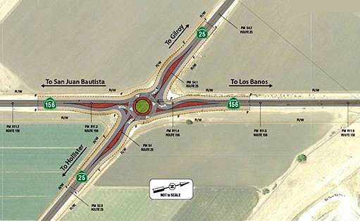 In August 2018, it was reported that Caltrans plans to build a roundabout at the intersection
of Route 25 and Route 156, scheduled for completion in August 2021. It
will eventually get replaced by an interchange when the Route 25 expansion
project moves forward at an undetermined time. The roundabout project with
a $7.7 million construction cost, to go with $3 million in “support
costs”, will be funded by the state as a safety improvement project
through the State Highway Operations and Protection Program, or SHOPP. The
project remains in initial planning stages. There is “concept
layout” and it is heading into the design and then construction
phases, said roundabout Project Manager Brandy Rider. Plans presented to
the local COG board in recent months show Caltrans will be ready to list
the roundabout project for bidding in late August 2020, and it is set for
a target end construction date at the end of October 2021. The roundabout
is separate, however, from the Route 25 expansion. The timing and
financing of that will depend on whether San Benito County taxpayers
approve a 30-year, 1 percent sales tax on the November ballot. Under
long-term Route 25 expansion plans, the roundabout would be replaced by an
interchange. That replacement would happen many years down the road, and
Rider said it could be 15 years or so until such a change might occur.
While Caltrans is paying for the roundabout, the state has made it clear
local taxpayers would have to cover the majority of the expansion funding,
which would come from the ballot measure if approved. The nearly $300
million expansion would result in a four-lane, 11.2-mile commuter highway
from Hollister to Santa Clara County.
In August 2018, it was reported that Caltrans plans to build a roundabout at the intersection
of Route 25 and Route 156, scheduled for completion in August 2021. It
will eventually get replaced by an interchange when the Route 25 expansion
project moves forward at an undetermined time. The roundabout project with
a $7.7 million construction cost, to go with $3 million in “support
costs”, will be funded by the state as a safety improvement project
through the State Highway Operations and Protection Program, or SHOPP. The
project remains in initial planning stages. There is “concept
layout” and it is heading into the design and then construction
phases, said roundabout Project Manager Brandy Rider. Plans presented to
the local COG board in recent months show Caltrans will be ready to list
the roundabout project for bidding in late August 2020, and it is set for
a target end construction date at the end of October 2021. The roundabout
is separate, however, from the Route 25 expansion. The timing and
financing of that will depend on whether San Benito County taxpayers
approve a 30-year, 1 percent sales tax on the November ballot. Under
long-term Route 25 expansion plans, the roundabout would be replaced by an
interchange. That replacement would happen many years down the road, and
Rider said it could be 15 years or so until such a change might occur.
While Caltrans is paying for the roundabout, the state has made it clear
local taxpayers would have to cover the majority of the expansion funding,
which would come from the ballot measure if approved. The nearly $300
million expansion would result in a four-lane, 11.2-mile commuter highway
from Hollister to Santa Clara County.
(Source: San Benito Live, 8/15/2018)
In August 2018, the CTC amended the SHOPP to add the
following project: 05-SBt-25 54.0 PPNO 2746, Project 0517000185, EA 1J480.
Route 25 Near Hollister, at the intersection of Route 25 and Route 156.
Improve safety by constructing a roundabout. Est. cost: $10,628,000. Est.
construction start: 10/28/2021.
(Source: August 2018 CTC Agenda Item 2.1a.(1))
In June 2019, it was reported that Caltrans District 5
will hold a public information meeting/open house about a proposed safety
roundabout project for the intersection of Route 25 and Route 156.
(Source: BenitoLink, 6/20/2019)
In December 2019, it was reported that the roundabout
planned for the Route 25/Route 156 intersection at Hollister’s north
end is moving forward and is on schedule. According to Caltrans, the
project is fully funded, its environmental review is completed and final
designs and right-of-way acquisitions are scheduled for August 2020. The
$10.7 million project aims to make the busy intersection safer.
Roundabouts are increasingly common in new residential developments, as a
substitute for four-way stops. The state has begun using them at busy
traffic-signaled intersections that have had high accident rates. New,
successful roundabout projects in Tracy and Palmdale match
Hollister’s traffic patterns, according to the state. The plan is a
short-term fix, however, as the state’s long-term vision is to
realign and widen Route 25 to four lanes and build an interchange at its
connection to Route 156. No date or funding has been set for that new
highway replacement for the jammed two-lane commuter route that Route 25
has become. The proposal to place an interchange at this location will not
be finalized, under best case scenarios, until 2028, according to
Caltrans. Construction on the roundabout could start as early as the
summer of 2021 with a winter 2021 completion date. The roundabout is a
2-lane design, and state planners said it will be able to handle big rigs.
(Source: San Benito.Com, 12/20/2019)
The 2020 SHOPP, approved in May 2020, included the
following Collision Reduction item of interest (carried over from the 2018
SHOPP): 05-San Benito-25 PM 54.0 PPNO 2746 Proj ID 0517000185 EA 1J480.
Route 25 Near Hollister, at the intersection of Route 25 and Route 156.
Improve safety by constructing a roundabout. Programmed in FY20-21, with
construction scheduled to start in June 2021. Total project cost is
$10,628K, with $7,663K being capital (const and right of way) and $2,965K
being support (engineering, environmental, etc.).
(Source: 2020 Approved SHOPP a/o May 2020)
In August 2021, the CTC approved the following SHOPP
amendment: 05-SBt-25 54.0 53.7/54.03 PPNO 05-2746;
ProjID 0517000185; EA 1J480. Route 25 Near Hollister, at the intersection
of Route 25 and Route 156. Improve safety by constructing a
roundabout. (Concurrent CONST and CON ENG allocation under Resolution
FP-21-12; August 2021.) Note: Split off environmental mitigation project
EA 1J481/PPNO 05-2746Y for landscape and monitoring work from parent
project EA 1J480/PPNO 05-2746. Updated financials: ($ × 1,000): Const
Cap $7,659 ⇒ $6,559; Total $10,628 ⇒ $9,528.
(Source: August 2021 CTC Agenda, Agenda Item
2.1a.(1d) #5)
Also in August 2021, the CTC approved an allocation
request for $12,022,000 for the State Highway Operation and Protection
Program (SHOPP) Safety Improvements project, on Route 25 in San Benito
County, to advertise the project. This request exceeds the programmed
amount by over 20%. This project is located on Route 25 near Hollister, at
the intersection of Route 25 and Route 156, in San Benito County. The
signalized intersection of Route 25 and Route 156 in San Benito County is
experiencing a pattern of broadside and rear end collisions, due to a
recurrence of red light runs. The purpose of this project is to improve
the intersection of Route 25/Route 156 by reducing the number and severity
of collisions. The project proposes to construct a roundabout at
this intersection with key features that include replacing the
intersection with a multi-lane roundabout which will minimize excessive
queuing and delay. The roundabout will operate under capacity, have
adequate queue storage, and be adequately sized to handle a truck
tractor-semitrailer. This project was originally programmed in 2018 for
$7,659,000 in construction capital and $1,455,000 in construction support
with construction in Fiscal Year 2020-21. The project also includes
landscape mitigation and plant establishment elements. A SHOPP
Technical Amendment is being requested concurrently, with this allocation
request, at the August 2021 Commission meeting to move the landscape
mitigation and plant establishment work to a child project (EA
05-1J481/PPNO 2746Y) for delivery in 2023-24, due to the three-year
establishment period. The child landscape project’s construction
capital and support will be funded with $1,100,000 from the parent
project’s construction capital. The updated Engineer’s
Estimate (EE) includes State furnished materials, mobilization, and
contingency for construction capital of $9,857,000; which is 50.3 percent
over the $6,559,000 remaining programmed amount after moving the landscape
mitigation and plant establishment elements. The updated
construction support estimate is $2,165,000; which is 48.8 percent over
the programmed amount. The project has an approved time extension
for allocation through August 2021. Pending the approval of this
request, the Department plans to advertise the project contract in
September 2021 and begin construction in February 2022. Construction
is planned for two seasons with 210 working days and completion by January
2023.
(Source: August 2021 CTC Agenda, Agenda Item
2.5d.(3))
The Department received extensive public input on this
project regarding truck movements and sought a peer review from an
external roundabout consultant. The peer review was conducted in
September 2020 and the findings centered on the design of the multi-lane
roundabout and how to best serve the high truck volumes. Based on the
public comments received, the design configuration was revised to reflect
an innovative turbo roundabout layout with raised lane dividers, to better
mitigate the potential for low-speed merging conflicts due to the acute
intersection angle of Route 25 and Route 156. Due to the restrictions
associated with the new turbo configuration and raised lane dividers,
overhead sign structures are needed on each of the four entries to aid
drivers in selecting the appropriate lane pertaining to their desired
destination. This is a departure from the standard wood-post signage
originally called out for in the project. Also, the diameter of the
circulatory roadway needs to be enlarged by 30 percent and the structural
section increased to adequately accommodate the volume of large vehicles
which regularly traverse the intersection. According to a Caltrans
spokesperson, the roundabout planned at that intersection will be the
first of its kind in California. The design known as a turbo roundabout is
240 feet in diameter, includes raised dividers to keep motorists from
changing lanes, and uses overhead and road markings for navigation.
Construction is expected to begin in January, pending weather conditions.
The overhead lane markings will note which lane leads to either Route 25
or Route 156, will be placed about 350 feet from the roundabout. The
intersection became a high priority for Caltrans because it has almost
double the average rate of collisions. According to Caltrans, there were
126 collisions between 2009 and 2018 with two fatalities. Caltrans will be
working on an easy-to-understand design they intend to present at public
hearings in the future. This is because the engineer’s design may be
difficult for the public to understand as it contains a lot more
information than just the drawings of the lanes. The roundabout design is
similar to one being constructed in Jacksonville, Florida. The turbo
roundabout was recently invented in the Netherlands. Its key feature is
that it prevents drivers from changing lanes, thus reducing rates of
roundabout collisions. Caltrans did not have to deal with property
acquisition for this project as it stayed within the existing
right-of-way. Additionally, the overpass that is planned at that
intersection as part of the Route 25 widening project will not be
constructed over the roundabout. Instead, Caltrans is working on designs
that may incorporate aspects of the roundabout to the overpass, which
would save money along the way.
(Source: August 2021 CTC Agenda, Agenda Item
2.5d.(3); BenitoLink, 8/30/2021)
The latest Engineering Estimate for the cost reflects
the current unit prices for projects going out to bid in the region and
shows the increase of $3,298,000. The increase is primarily driven
by the increase in hot mix asphalt (11,000 tons to 19,500 tons), four
overhead sign structures, additional temporary traffic controls, and
additional roadway excavation. In addition, the original roundabout
design included a center island with planting and a one- year plant
establishment to be included with the road project. During final
reviews, Department maintenance staff requested that all planting be
eliminated from the center island, due to safety concerns and the
long-term maintenance of vegetation within the center island. The
design changes due to the removal of the center island planting resulted
in the need to re-evaluate the Visual Impact Analysis. The
re-evaluation recommended landscaping be placed outside the roundabout to
mitigate for additional signs structures and the lighting features as
required by the new design. This resulted in the need for a split off
landscape project to accommodate the new planting plan and a three-year
plant establishment period at a cost of $1,100,000. A construction support
cost increase of 48.8 percent is also needed due to an increase of working
days, from 130 to 210, and the complicated turbo roundabout design staging
needed during construction. Additionally, on-going coordination with the
local community identified the need for greater outreach to the community
and a public awareness campaign during construction.
(Source: August 2021 CTC Agenda, Agenda Item
2.5d.(3))
In December 2021, there was an update on the status of
this project: The roundabout is planned for the intersection of Route 25
and Route 156, north of Hollister. Bidding was opened on Oct. 27 with the
contract for the $10.7 million project awarded to GraniteRock
Construction, according to Caltrans Public Information Officer Kevin
Drabinski. Construction is scheduled to begin in February 2022.
(Source: BenitoLink, 12/8/2021)
 In May 2022, construction began on Route 25/Route 156
roundabout. The initial phase of construction will result in lane closures
on the approach to the north Hollister intersection, from westbound Route 156 and southbound Route 25. The project is expected to be completed in
April 2023. The roundabout is planned as an interim solution. An
interchange at Route 25/Route 156 is the long-range improvement planned as
part of the larger Route 25 Expressway Conversion Project. The Measure
G-funded project to widen Route 25 (to be completed over the coming years)
will also include a permanent interchange at this intersection. The
roundabout is a critical safety project designed to hasten the reduction
of the number and severity of collisions at this intersection. The
Caltrans State Highway Operation and Protection Program, which funds
safety projects, identified the need to address immediate safety at this
location. In the interim, Caltrans is addressing this safety need until
the long-range plan for an interchange can be implemented. Although the
proposed roundabout is located at the junction of two high-speed rural
routes, the roundabout design will emphasize speed control. Design
features will control the speed at which vehicles enter, navigate, and
exit the roundabout. Lower vehicle speeds provide more time for entering
drivers to judge, adjust speed for, and enter a gap in circulating
traffic, allowing for safer merges while reducing the frequency and
severity of collisions. The roundabout is a two-lane design and
anticipates truck volumes for the intersection today and into the future.
In accommodating the sweep of truck trailer wheels, a mountable truck
apron is featured around the inside of the roundabout.
In May 2022, construction began on Route 25/Route 156
roundabout. The initial phase of construction will result in lane closures
on the approach to the north Hollister intersection, from westbound Route 156 and southbound Route 25. The project is expected to be completed in
April 2023. The roundabout is planned as an interim solution. An
interchange at Route 25/Route 156 is the long-range improvement planned as
part of the larger Route 25 Expressway Conversion Project. The Measure
G-funded project to widen Route 25 (to be completed over the coming years)
will also include a permanent interchange at this intersection. The
roundabout is a critical safety project designed to hasten the reduction
of the number and severity of collisions at this intersection. The
Caltrans State Highway Operation and Protection Program, which funds
safety projects, identified the need to address immediate safety at this
location. In the interim, Caltrans is addressing this safety need until
the long-range plan for an interchange can be implemented. Although the
proposed roundabout is located at the junction of two high-speed rural
routes, the roundabout design will emphasize speed control. Design
features will control the speed at which vehicles enter, navigate, and
exit the roundabout. Lower vehicle speeds provide more time for entering
drivers to judge, adjust speed for, and enter a gap in circulating
traffic, allowing for safer merges while reducing the frequency and
severity of collisions. The roundabout is a two-lane design and
anticipates truck volumes for the intersection today and into the future.
In accommodating the sweep of truck trailer wheels, a mountable truck
apron is featured around the inside of the roundabout.
(Source: San Benito County on FB, 5/31/2022)
In August 2023, it was reported that the next stage of
construction of the roundabout project project at Route 25 and Route 156,
crews will implement a new, temporary traffic configuration that will
operate similar to a one-lane roundabout. The configuration will remain in
place through the end of the project’s construction in early 2024.
During construction, as vehicles approach, they will be required to slow
down and yield to traffic already in the roundabout before entering. There
will be no signalized traffic lights in place, and travelers will see new
yield signage and other alerts to advise of the upcoming intersection
change. One week before the one-lane roundabout is implemented,
Caltrans will place electronic message signs to alert motorists of the
upcoming configuration change. Speed limits within the project area remain
reduced to 35 mph. This temporary traffic configuration is necessary to
allow crews to complete final work inside the middle of the intersection
for the future “Turbo Roundabout.” When complete, the
roundabout project will be designed to reduce the number and severity of
collisions at the intersection of Route 25 and Route 156. The project will
cost about $14.6 million.
(Source: SanBenito.Com, 8/8/2023)
In January 2024, it was reported that the "Turbo
Roundabout" at the intersection of Route 25 and Route 156 has opened. In a
typical multi-lane roundabout, drivers freely shift between inner and
outer lanes, delineated by painted lines. In a turbo roundabout, raised
dividers separate the lanes. This means that when drivers merge onto the
roundabout, they choose a lane — inner, center or outer — and
stick with it until they peel off. The facility became fully operational
when the third lane opened for traffic in December; however, temporarily,
only one roundabout lane is open while Caltrans installs striping and
signage on the roundabout. That was completed by February 2024. As this
form of roundabout may be unfamiliar, Caltrans released a how-to video on
Youtube—in both English and Spanish—advising travelers how to approach and navigate the new intersection, which is the
first of its kind in California. The roundabout cost a total of
$14.9 million, $11.1 million for construction and $3.8 million for support
costs.
(Source: SFGate, 1/2/2024; KSBW, 2/16/2024; Gilroy Dispatch, 2/19/2024)
US 101/Route 25 Interchange (~ SCL 2.504)
 In June 2021, it was reported that the updated US 101/Route 25 interchange is still being designed. The goal of the project
is to increase the length of the southbound US 101 offramp by more than
1,000 feet, in order to prevent vehicles from stacking on US 101 during
peak commute hours. Traffic signals would be installed where the offramp
meets Route 25, and traffic would turn east over a newly constructed
four-lane overpass that spans US 101. Once crossing the overpass, which
would be located slightly north of the current overcrossing, another
signalized intersection will be constructed where the northbound off-ramp
meets Route 25. The overall project, which also includes widening US 101
from Monterey Road to Route 129 as well as extending Santa Teresa
Boulevard to Route 25, will be built in phases due to limited funding. The
first phase, which includes the new overpass, is expected to cost
$100 million, to Adam, funded by Senate Bill 1 and the 2016 voter-approved
Measure B. The project is currently in the design phase, and an addendum
is being drafted for the 2013 VTA Board-approved Environmental Impact
Report for the overall US 101 widening project. Construction on the
overpass could begin in summer 2023 and wrap up in early 2026. The
existing interchange was constructed in 1988 as a temporary way to prevent
drivers from turning left on US 101 to Route 25. Since then, traffic has
increased heavily, with vehicles looking to turn onto Route 25 spilling
onto the US 101 shoulder and backing up to the Monterey Road onramp. In
addition, the current configuration of the interchange has seen
“higher than average accident rates” compared to statewide
collision rates. The project would eliminate US 101 access from Castro
Valley and Mesa roads, which are popular spots for commuters looking to
avoid the bottleneck that occurs when the highway goes down from three
lanes to two at Monterey Road.
In June 2021, it was reported that the updated US 101/Route 25 interchange is still being designed. The goal of the project
is to increase the length of the southbound US 101 offramp by more than
1,000 feet, in order to prevent vehicles from stacking on US 101 during
peak commute hours. Traffic signals would be installed where the offramp
meets Route 25, and traffic would turn east over a newly constructed
four-lane overpass that spans US 101. Once crossing the overpass, which
would be located slightly north of the current overcrossing, another
signalized intersection will be constructed where the northbound off-ramp
meets Route 25. The overall project, which also includes widening US 101
from Monterey Road to Route 129 as well as extending Santa Teresa
Boulevard to Route 25, will be built in phases due to limited funding. The
first phase, which includes the new overpass, is expected to cost
$100 million, to Adam, funded by Senate Bill 1 and the 2016 voter-approved
Measure B. The project is currently in the design phase, and an addendum
is being drafted for the 2013 VTA Board-approved Environmental Impact
Report for the overall US 101 widening project. Construction on the
overpass could begin in summer 2023 and wrap up in early 2026. The
existing interchange was constructed in 1988 as a temporary way to prevent
drivers from turning left on US 101 to Route 25. Since then, traffic has
increased heavily, with vehicles looking to turn onto Route 25 spilling
onto the US 101 shoulder and backing up to the Monterey Road onramp. In
addition, the current configuration of the interchange has seen
“higher than average accident rates” compared to statewide
collision rates. The project would eliminate US 101 access from Castro
Valley and Mesa roads, which are popular spots for commuters looking to
avoid the bottleneck that occurs when the highway goes down from three
lanes to two at Monterey Road.
(Source: SanBenito.Com, 6/17/2021; For more information: VTA Project Page; Image source: SanBenito.Com)
In June 2022, it was reported that
the Santa Clara Valley Transportation Authority Board of Directors
approved a document that completes another step in the years-long process
to construct a new overcrossing at the US 101/Route 25 interchange. The
board unanimously approved the addendum to an environmental report for a
US 101 widening project that was previously approved in 2013. The addendum
focuses on the first phase of the US 101/Route 25 interchange, and
determined that mitigation measures in place for the project would not add
any new or significant environmental effects. Located just south of Gilroy
city limits, the current interchange, built in 1988, was originally meant
to be a temporary way to prevent drivers from turning left on US 101 to
Route 25. However, the interchange has proven inadequate as the population
has grown over the decades, and traffic on southbound US 101 backs up past
Monterey Street during daily commute hours, as drivers attempting to
navigate onto Route 25 into San Benito County line up on the
freeway’s shoulder. While still being designed, the project would
increase the length of the southbound US 101 offramp by more than 1,000
feet, with the goal of preventing vehicles from stacking on US 101 during
peak commute hours. Traffic signals would be installed where the offramp
meets Route 25, and traffic would turn east over a newly constructed
four-lane overpass that spans US 101. Once crossing the overpass, which
would be located slightly north of the current overcrossing, another
signalized intersection will be constructed where the northbound off-ramp
meets Route 25. The overall project, which also includes widening US 101
from Monterey Street in Gilroy to Route 129 in San Benito County as well
as extending Santa Teresa Boulevard to ROute 25, will be built in phases
due to limited funding. The project is expected to cost at least $500
million in today’s dollars. The first phase, which includes
the new overpass, is expected to cost $100 million. Construction is
tentatively planned to begin in mid-2024 and take three years to complete.
With the June 2 approval, the VTA will continue seeking right-of-way
approvals on properties surrounding the project. That includes acquiring
and demolishing the Garlic Shoppe and Rapazzini Winery, which are in the
path of the proposed northbound US 101 off- and on-ramps, according to the
VTA’s addendum. The first phase of construction would also block off
highway access on Castro Valley and Mesa roads, two popular merging points
for commuters looking to bypass the congested Monterey Street onramp.
Traffic would detour through Gilroy to the Monterey Street onramp until
the Santa Teresa Boulevard extension to the new interchange is completed,
which currently has no timeline.
(Source: Gilroy Dispatch, 6/10/2022)
 Other WWW Links
 Naming
"Bolsa Road"
 Scenic Route
[SHC 263.3] Entire portion.
 Freeway
[SHC 253.3] From Route 180 near Paicines to Route 156 in Hollister, and from Route 156 in Hollister to US 101. Added to the Freeway and Expressway system in 1959.
 Business Routes
Portions of the route through Hollister are signed as Business Route 25.
 National Trails
 This route is part of the De Anza National Historic Trail.
 Statistics
Overall statistics for Route 25:
 Pre-1964 Legislative Route
The route that would become LRN 25 was first defined in the 1909 First Bond Act as running from Nevada City to Downieville. In 1933, it received two extensions: [LRN 37] near Colfax to [LRN 17] near Grass Valley, and [LRN 25] at Downieville to Blairsden-Truckee Road near Sattley. In 1935, it was codified into the state highway code as:
The portion from Nevada City to Downieville was considered a primary route. This definition remained unchanged until the great renumbering in 1963.
Signage on the route was as follows:
This signage of this segment pre-1964 is unclear, but it is currently signed as Route 174.
This is currently signed as Route 49, and runs between Route 20 (LRN 15) and Route 89 (LRN 83).
© 1996-2020 Daniel P. Faigin.
Maintained by: Daniel P. Faigin
<webmaster@cahighways.org>.
 Route 24
 Route 26