
 California Highways:
Click here for a key to the symbols used. An explanation of acronyms may be found at the bottom of the page.
 Routing
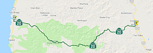 From Route 1 near Fort Bragg to Route 101 at Willits.
 Post 1964 Signage History
This routing is unchanged from its 1963 definition.
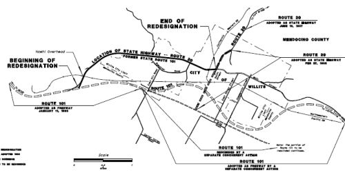
Willits Bypass (101 MEN 43.743 to MEN 48.69)
Note: For more information on the Willits Bypass, see the discussion of the Willits Bypass in the STATUS section of the segment of US 101 N of San Francisco.
The March/April 1963 California Highways & Public
Works referenced a planned 12.2 mile freeway segment of US 101 being
adopted as a bypass of Willits. The adopted freeway alignment is
cited to have a planned beginning at the Northwestern Pacific railroad
underpass south of downtown Willits with a northern termination point at
Reeves Creek. The southern segment of the Willits Freeway was
constructed to Haehl Creek by 1969, bypassing bypassed the Northwestern
Pacific Railroad underpass that is now part of Walker Road. The late
1980s/early 1990s saw a series of environmental impact and engineering
studies take place to determine the viability of a freeway bypass of
Willits. Ultimately this resulted in a February 2008 route adoption
of the Willits Bypass. The Willits Bypass alignment carried
substantial differences compared to the 1963 Willits Freeway. The Willits
Bypass was conceived as a four lane freeway alignment but the project was
met with heavy resistance. Ultimately the Willits Bypass was
constructed as a Super Two Freeway and was dedicated on November 3rd,
2016. See the linked Gribblenation blog for more details, including
links to maps and pictures.
(Source: Gribblenation Blog (Tom Fearer), “US Route 101 and California State Route 20 in Willits”, March 2021)
Note: With the completion of the Willits Bypass in
November 2016, the old alignment of US 101 through Willits will become
part of Route 20 south of the point where it comes in from Fort Bragg, and
the portion north of Route 20 is supposed to be relinquished to the city.
Main Street north of Flower Street/CA 20 in Willits wasn't relinquished
until it was fully repaved by Caltrans in late 2018. However, as of May
2021, the postmile tool was still showing US 101 on Main Street (the
original routing), and was not giving postmiles for the new bypass, nor
was it giving Route 20 postmiles for the segment along Main Street.
(Source: Joe Rouse @ AARoads, 11/23/2016; Gribblenation Blog (Tom Fearer), “US Route 101 and California State Route 20 in Willits”, March 2021; Daniel Faigin, May 2021)
 Pre 1964 Signage History
This segment was signed as Route 20 sometime after 1953 and was LRN 15. It was defined as part of the state highway system in 1953 by Chapter 1408 when the origin of LRN 15 was extended to [LRN 56] near Fort Bragg. It was not shown on 1953 highway maps.
The unbuilt extension of LRN 15 can be viewed between Willits at US 101
and Fort Bragg on the 1954 State Highway Map. Ultimately, however, a new
alignment for LRN 15 was not built and Route 20 was allocated to existing
roadways between US 101 and Route 1, which can be seen on the 1958 State
Highway Map. See the linked Gribblenation blog for more details,
including links to maps and pictures.
(Source: Gribblenation Blog: California State Route 20; from I–80 in Emigrant Gap west to CA 174, 10/2018)
In Willits, US 101 was originally routed along Main Street as early as
1917, when the route was simply (unsigned) LRN 1. Around 1937, US 101/Redwood Highway was greatly improved on the outskirts of Willits
An article in CHPW from that time references two ongoing projects
anticipated to be completed during summer of 1937 that would eliminate 47
curves from US 101/Redwood north and south of Willits. In
1953, LRN 15 was extended from Ukiah to Fort Bragg via Willits. This would
eventually become Route 20. By 1958, Route 20 was extended through Willits
via Fort Bragg-Willits Road to Route 1. This extension of Route 20
included a multiplex of US 101 north of Ukiah into downtown Willits,
incorporating existing Flower Road and Fort Bragg-Willits Road as part of
Route 20/LRN 15. See the linked Gribblenation blog for more details,
including links to maps and pictures..
(Source: Gribblenation Blog (Tom Fearer), “US Route 101 and California State Route 20 in Willits”, March 2021)
 Status
In February 2019, the CTC allocated $14,000 in right-of-way support costs
for a project on Route 20 that will replace the Bachelor Creek Bridge (MEN
005.84, Bridge 14-0001) near Upper Lake approximately three miles west of
the Route 20/Route 29 intersection. The current multi-plate steel culvert
bridge will be replaced with precast concrete box culverts.
(Source: Lake County Record Bee, 2/6/2019)
Route 20 Realignment (01-Men-20, PM 16.8/17.2)
 In October 2016, the CTC amended
the following into the SHOPP program: 1-Men-20 16.9/17.2 | Route 20 Near
Fort Bragg and Dunlap, from 0.34 mile west of Road 200A to 0.13 mile west
of Road 200A. Widen shoulders, install center and edge-line rumble strips,
and install guardrail. Allocation: $88K (R/W), $1.339MM (C), Support (PA
& ED $782K / PS & E $1.117MM / RW Sup $129K / Con Sup $1.063MM /
Total $3.091MM). FY 18/19.
In October 2016, the CTC amended
the following into the SHOPP program: 1-Men-20 16.9/17.2 | Route 20 Near
Fort Bragg and Dunlap, from 0.34 mile west of Road 200A to 0.13 mile west
of Road 200A. Widen shoulders, install center and edge-line rumble strips,
and install guardrail. Allocation: $88K (R/W), $1.339MM (C), Support (PA
& ED $782K / PS & E $1.117MM / RW Sup $129K / Con Sup $1.063MM /
Total $3.091MM). FY 18/19.
In October 2018, the CTC approved for future
consideration of funding the following project for which a Mitigate
Negative Declaration (MND) has been completed: Route 20 in Mendocino
County (01-Men-20, PM 16.8/17.2). Realign curves on a portion of Route 20
near Fort Bragg in Mendocino County. (PPNO 4613) This project is located
on Route 20 near Fort Bragg in Mendocino County. The project proposes to
realign a series of compound curves. The project also proposes to increase
the clear recovery zone adjacent to the roadway, improve sight distance,
increase shoulders, construct center lines, install guardrail and
construct centerline and edgeline rumble strip. In addition, the project
proposes to replace/extend the existing culverts, and adding to a new
culvert with appropriate end treatments. This proposed project addresses
the need to reduce the frequency and severity of run-off road collisions.
The proposed project is estimated to cost approximately $5.7 million. This
project is currently funded and programmed in the 2018 State Highway
Operations and Protection Program (SHOPP) for approximately $5.5 million.
Construction is estimated to begin in 2019. The scope, as described for
the preferred alternative, is consistent with the project scope programmed
by the Commission in the 2018 SHOPP.
(Source: October 2018 CTC Agenda Item 2.2c.(1))
In August 2019, the CTC approved the following SHOPP
Safety Allocation: 01-Men-20 16.9/17.2 PPNO 4613 Proj ID 0115000038 EA
0E860. On Route 20 Near Fort Bragg, from 0.3 mile west of Road 200A to 0.1
mile west of Road 200A. Outcome/Output: Improve safety by realigning
curve, widening shoulders to four feet, and constructing centerline and
shoulder rumble strips. Also improve clear recovery zone and drainage.
This project will reduce the number and severity of collisions. $3,743,000
(Source: August 2019 CTC Agenda, Agenda Item
2.5f.(3) #1)
James Creek Bridge Curve West Improvement (01-Men-20 19.1/19.6 PM )
 In October 2018, the CTC amended the 2018 SHOPP to add
the following project: 01-Men-20 19.1/19.6. PPNO 4691. Project 0117000225.
EA 0H450. Route 20 Near Willits, from 0.9 mile west to 0.4 mile west of
James Creek Bridge. Improve curve, install center and edge-line rumble
strips, upgrade guardrail, and widen shoulders. Est. cost: $5,483,000.
Est. const. begin: 10/17/2021. They also approved the following
allocation: PS&E $775,000. RW Sup $129,000.
In October 2018, the CTC amended the 2018 SHOPP to add
the following project: 01-Men-20 19.1/19.6. PPNO 4691. Project 0117000225.
EA 0H450. Route 20 Near Willits, from 0.9 mile west to 0.4 mile west of
James Creek Bridge. Improve curve, install center and edge-line rumble
strips, upgrade guardrail, and widen shoulders. Est. cost: $5,483,000.
Est. const. begin: 10/17/2021. They also approved the following
allocation: PS&E $775,000. RW Sup $129,000.
(Source: October 2018 CTC Agenda Item 2.1a.(1) Item
17; Agenda Item 2.5b.(2a) Item 3; Image source: James Creek West Safety Project Initial Study/Proposed Negative Declaration)
The 2020 SHOPP, approved in May 2020, included the
following Collision Reduction item of interest (carried over from the 2018
SHOPP): 01-Mendocino-20 PM 19.1/19.6 PPNO 4691 Proj ID 0117000225 EA
0H450. Route 20 near Willits, from 0.9 mile west to 0.4 mile west of James
Creek Bridge. Improve curve, install center and edge-line rumble strips,
upgrade guardrail, and widen shoulders. Programmed in FY21-22, with
construction scheduled to start in June 2022. Total project cost is $5,669
K, with $2,795 K being capital (const and right of way) and $2,874 K being
support (engineering, environmental, etc.).
(Source: 2020 Approved SHOPP a/o May 2020)
In July 2020, the James Creek West Safety Project Initial Study/Proposed Negative Declaration was released for public review. According the the initial study, the
proposed project would include the following:
(Source: District 1 Public Notice on FB, 7/6/2020; James Creek West Safety Project Initial Study/Proposed Negative Declaration,
June 2020)
The initial study notes that to improve and realign the
compound curve between PM 19.34 and PM 19.52, approximately 45 feet of an
existing cut slope on the north side of the roadway would be
excavated. Vegetation within the cut would be removed, which would cut
fewer than 144 trees greater than 4 inches in diameter at breast high
(DBH). The existing roadway centerline would be shifted approximately 50
feet north and two 12-foot-wide lanes would be constructed. The existing
2-foot-wide eastbound and westbound shoulders would be widened to 4 feet
and paved. Approximately 3 feet of shoulder backing would be placed
adjacent to the widened shoulders. Around 5,100 cubic yards of excess
material would be removed from the project area and become property of the
contractor. Excavation and grinding of the existing pavement structural
section would be required. New pavement structural sections, consisting of
compacted base material and hot mix asphalt, would be constructed.
Centerline and shoulder rumble strips and high visibility striping would
be added throughout the project limits. Striping for a Class II1 bicycle
lane would be installed on both the eastbound and westbound lanes. To
realign the roadway and make room for the new cut, Caltrans would work
with CAL FIRE to transfer jurisdiction of 0.63 acre and grant a temporary
construction easement (0.14 acre). Construction staging would occur on the
existing paved roadway and on gravel pullouts within and adjacent to the
project limits. Construction is anticipated to start in 2022 and last 6 to
7 months.
In December 2020, the CTC approved for future
consideration of funding the following project for which a Negative
Declaration (ND) has been completed: Route 20 in Mendocino County
(01-Men-20, PM 19.10/19.60). Improve a curve, replace guardrail, and
widen shoulders on SR 20 in Mendocino County. (PPNO 4691) This project is
located on Route 20 in Mendocino County. The Department proposes to
improve curves, widen shoulders, and upgrade guardrail on Route 20 between
post miles 19.1 and 19.6 in Mendocino County. This project is fully funded
and is currently programmed in the 2020 SHOPP for a total of $5,669,000
which includes Construction (capital and support) and Right of Way
(capital and support). Construction is estimated to begin FY 2021-2022.
The scope, as described for the preferred alternative, is consistent with
the project scope programmed by the Commission in the 2020 SHOPP.
(Source: December 2020 CTC Agenda, Agenda Item
2.2c.(1))
In December 2020, the CTC approved the following SHOPP
Support Phase allocation: $1,079,000 for PS&E and $220,000 for R/W Sup
for 01-Men-20 PM 19.1/19.6. PPNO 01-4691 ProjID 0117000225 EA 0H450. Route 20 Near Willits, from 0.9 mile west to 0.4 mile west of James Creek
Bridge. Improve curve, install center and edge-line rumble strips,
upgrade guardrail, and widen shoulders. (Concurrent consideration of
funding under Resolution E-20-112; December 2020.)
(Source: December 2020 CTC Agenda, Agenda Item
2.5b.(2a) #2)
In March 2022, the CTC was informed of the following
allocation: $3,425,000. 01-Men-20 19.1/19.6. PPNO 01-4691; ProjID
0117000225; EA 0H450. Route 20 near Willits, from 0.9 mile west to 0.4
mile west of James Creek Bridge. Outcome/Output: Improve
safety by widening shoulders, improving curves, upgrading guardrail, and
installing rumble strips. This project will reduce the number and
severity of collisions. (Future consideration of funding approved under
Resolution E-20-112; December 2020.) (EA 0H450/PPNO 01-4691 combined with
EA 0J120/PPNO 01-4717 for construction under EA 0H45U/Project ID
0121000104.) Allocation: CON ENG $821,000; CONST $2,635,000. Allocation
Date: 01/31/2022.
(Source: March 2022 CTC Agenda, Agenda Item
2.5f.(3) #1)
James Creek Bridge Curve East Improvement (01-Men-20 PM 20.0/20.3)
In May 2019, the CTC amended the 2018 SHOPP to add the
following project: Collision Reduction #25: 01-Men-20 PM 20.0/20.3. PPNO
4717 Proj ID 0118000171. Route 20 Near Willits, from James Creek Bridge to
0.3 mile east of James Creek Bridge. Improve curve and roadway cross
slope, widen shoulders, and install rumble strips. Timetable: PA&ED:
7/2020. R/W: 8/2021. Const: 3/2022. Est. cost: $4,094K. The CTC also
approved the following SHOPP support allocation: 01-Men-20 20.0/20.3.
Route 20 Near Willits, from James Creek Bridge to 0.3 mile east of James
Creek Bridge. Improve curve and roadway cross slope, widen shoulders, and
install rumble strips. (Concurrent amendment under SHOPP Amendment
18H-009.) PPNO 4717. ProjID 0118000171. PA&ED $944,000.
(Source: May 2019 CTC Agenda Item 2.1a.(1) Item 25;
Agenda Item 2.5b.(2a) Item 6)
The 2020 SHOPP, approved in May 2020, included the
following Collision Reduction item of interest (carried over from the 2018
SHOPP): 01-Mendocino-20 PM 20.0/20.3 PPNO 4717 Proj ID 0118000171 EA
0J120. Route 20 near Willits, from James Creek Bridge to 0.3 mile east of
James Creek Bridge. Improve curve and roadway cross slope, widen
shoulders, and install rumble strips. Programmed in FY21-22, with
construction scheduled to start in May 2022. Total project cost is $4,094
K, with $1,130K being capital (const and right of way) and $2,964K being
support (engineering, environmental, etc.).
(Source: 2020 Approved SHOPP a/o May 2020)
In August 2020, the CTC approved the following
financial allocation: $839,000 for PS&E, $142,000 for R/W Support.
01-Men-20 PM 20.0/20.3.PPNO 4717 ProjID 0118000171 EA 0J120. Route 20 Near
Willits, from James Creek Bridge to 0.3 mile east of James Creek Bridge.
Improve curve and roadway cross slope, widen shoulders, and install rumble
strips.
(Source: August 2020 CTC Agenda, Agenda Item
2.5b.(2a) #2)
In March 2022, the CTC was informed of the following
allocation: $2,345,000. 01-Men-20 20.0/20.3. PPNO 01-4717; ProjID
0118000171; EA 0J120. Route 20 Near Willits, from James Creek Bridge to
0.3 mile east of James Creek Bridge. Outcome/Output: Improve
safety by widening shoulders, realigning a curve,and installing rumble
strips. This project will reduce the number and severity of collisions.
(EA 0J120/PPNO 01-4717 combined with EA 0H450/PPNO 01-4691 for
construction under EA 0H45U/Project ID 0121000104.) Allocation: CON ENG
$1,080,000 CONST $1,100,000. Allocation Date: 01/31/2022
(Source: March 2022 CTC Agenda, Agenda Item
2.5f.(3) #2)
In March 2017, the CTC approved $675,000 in emergency SHOPP funding for storm damage along Route 20 due to the winter 2017 storms, near Willits, at 0.8 mile east of James Creek Bridge (01-Men-20 20.8). Heavy rains beginning January 7, 2017 resulted in a landslide and complete roadway closure. The volume and continuing slide movement have overwhelmed maintenance force efforts. This project will place and maintain a debris flow barrier; remove debris, hazardous trees, and unstable materials; stabilize the slope; repair drainage systems and the roadway surface; and dewater and provide erosion control. The project will also provide on-going traffic control to keep the roadway safely open to the traveling public. Ongoing geotechnical studies will determine final strategies for slope stability.
Widening Near Three Chop Road (MEN 24.7/24.9)
In January 2019, the CTC approved the following support
allocation: 01-Men-20 24.7/24.9 PPNO 4650. Proj ID 0116000188. Route 20
Near Willits, from 1.0 mile to 0.8 mile west of Three Chop Road. Widen
eastbound shoulders, construct guard railing, place High Friction Surface
Treatment (HFST), and extend an existing culvert. Allocation: PS&E
$843,000; R/W Sup $175,000.
(Source: January 2019 CTC Minutes, Agenda Item
2.5b.(2a) Item 1)
In May 2019, the CTC approved the following SHOPP
Amendment: 01-Men-20 24.7/24.9. PPNO 4650. ProjID 0116000188. On Route 20
Near Willits, from 1.0 mile to 0.8 mile west of Three Chop Road. Realign
curves Widen eastbound shoulders, construct guard
railing, place Open Graded Friction Course (OGFC) pavement High
Friction Surface Treatment (HFST), and extend an existing culvert.
Note: Design strategy has changed from shoulder widening to curve
correction resulting in increased construction capital. R/W capital has
decreased due to lower than anticipated permit fees. Updated est. cost:
$4,402K.
(Source: May 2019 CTC Agenda Item 2.1a.(1) Amend
Item 9)
In January 2020, the CTC approved an additional $928,000 be allocated
from a Non-Budget Act Item for PPNO 4587, 01-MEN-20 33.3/34.4, on Route 20
Near Ukiah, from North Calpella Overcrossing to
0.5 mile east of County Road 144 at Russian River Bridge and Overhead No.
10-0182 and Redwood Valley Undercrossing No. 10-0183. Outcome/Output:
Replace two bridges with a single bridge on a new alignment. The
project will construct a new bridge to replace two existing bridges that
are at the risk of failure due to their deteriorated bridge decks. The new
bridge will improve the safety, connectivity, and
reliability of the bridge for hikers, bikers, travelers and commuters.
This bridge project is in a floodplain, in a high environmental
sensitivity area in the Russian River watershed, and over a railroad.
Because of the complexities involved with the site location, it requires
extensive coordination with resource agencies and the railroad owner to
discuss concerns regarding bridge construction methods and the impact of
extensive
construction work in the river bed below the bridge. This project was
programmed for delivery in 2020-21. The PA&ED phase was allocated in
June 2017 for $2,087,000. With the available G-12 authority, the total
allotment for the COS-PA&ED phase is $2,496,000. A total of $2,041,000
of the budget has been expended to complete 85 percent of the
pre-construction work required to complete the PA&ED phase. However,
the Department is requesting supplemental funds in the amount of $928,000
to be able to complete the phase. The additional resources are needed to
obtain the required permits before commencing the
Plan, Specification & Estimate (PS&E) phase, which will enable the
Department to complete the bridge design and prepare all project contract
documents and plans in time to meet the planned April 2021 Ready to List
(RTL) date.
(Source: January 2020 CTC Agenda, Agenda Item
2.5e.(1))
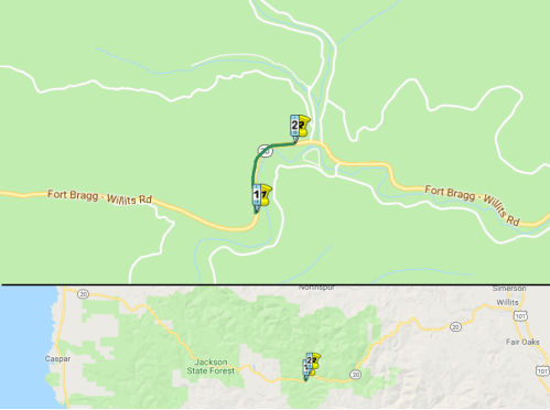
Former US 101 (MEN 46.293 to MEN T43.778)
 In February 2008, the CTC approved redesignating a portion of former US 101
as Route 20 as part of the Willits Bypass project (~ MEN R33.072; the US 101 portion is MEN 46.293 to MEN T43.778). The Willits Bypass project
proposes to construct a four-lane freeway on a new alignment with full
access control just east of Willits. The freeway will depart from existing
Route 101 approximately 0.3 miles south of the Haehl Overhead and will end
approximately 1.8 miles south of Reynolds Highway along the existing Route 101 alignment just south of the at-grade rail crossing of the Northwestern
Pacific Railway. Since the new alignment of Route 101 will no longer
connect to Route 20, the project proposes redesignation of the existing
portion of Route 101, from 0.3 miles south of Haehl Overhead to Route 101/
Route 20 junction, to Route 20. This redesignation will provide a link
from Route 20 to Route 101 and maintain route connectivity as required by
the Streets and Highway Code, State Highway System, Section 320. It is
unclear when the legislative definition will be updated. Note: Much more
information on the Willits Bypass is on the page for US 101.
In February 2008, the CTC approved redesignating a portion of former US 101
as Route 20 as part of the Willits Bypass project (~ MEN R33.072; the US 101 portion is MEN 46.293 to MEN T43.778). The Willits Bypass project
proposes to construct a four-lane freeway on a new alignment with full
access control just east of Willits. The freeway will depart from existing
Route 101 approximately 0.3 miles south of the Haehl Overhead and will end
approximately 1.8 miles south of Reynolds Highway along the existing Route 101 alignment just south of the at-grade rail crossing of the Northwestern
Pacific Railway. Since the new alignment of Route 101 will no longer
connect to Route 20, the project proposes redesignation of the existing
portion of Route 101, from 0.3 miles south of Haehl Overhead to Route 101/
Route 20 junction, to Route 20. This redesignation will provide a link
from Route 20 to Route 101 and maintain route connectivity as required by
the Streets and Highway Code, State Highway System, Section 320. It is
unclear when the legislative definition will be updated. Note: Much more
information on the Willits Bypass is on the page for US 101.
In August 2023, it was reported that Caltrans has
secured funds to improve the safety of Route 20 (Old Highway 101) from Oak
Street to Manor Way in Willits. The project will implement a “road
diet” by modifying the striping to add bike lanes. The concept for
the project is based on the 2017 Willits Main Street Corridor Enhancement
Plan and allows for future enhancements. They were holding public meetings
related to the project.
(Source: Redheaded Blackbelt, 8/12/2023)
 Scenic Route
[SHC 263.3] Entire portion.
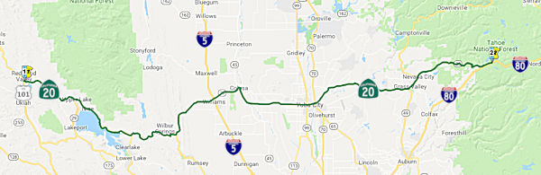 From Route 101 to Route 80 near Emigrant Gap via Williams
and Colusa.
From Route 101 to Route 80 near Emigrant Gap via Williams
and Colusa.
Post 1964 Signage History▸This segment is unchanged from its original 1963 routing.
The route between Colusa and Route 45 near Sycamore is signed as Route 45, although it is legislatively Route 20.
The route between Route 20 near Grass Valley and Route 20 near Nevada City is signed as Route 49, although it is legislatively Route 20.
The segments within Grass Valley (03-Nev-174-PM 9.6/10.2, 03-Nev-20-PM
12.9/13.3) were relinquished in August 2022, when the CTC authorized
relinquishment of right of way in the city of Grass Valley along Route 174
(Colfax Avenue) from Route 20 to Race Street, along Route 20 on Tinloy
Street from South Auburn Street to Bank Street, on Hansen Way from Colfax
Avenue to East Bennett Street, and along Neal Street and South Auburn
Street, under the terms and conditions as stated in the relinquishment
agreement dated October 13, 2021 and determined to be in the best interest
of the State. The relinquishment was authorized by Chapter 82,
Statutes of 2020, which amended Section 474 of the Streets and Highways
Code.
(Source: August 2022 CTC Agenda, Agenda Item 2.3c)
A discussion of the Highways to Boulevards program during the March 2022
CTC meeting identified the following segment(s) as potential Highways to
Boulevards conversion projects: Route 20 in Lake County.
(Source: March 2022 CTC Agenda, Agenda Item 4.3)
Pre 1964 Signage History In 1934, Route 20 was signed
from Jct. US 101 near Ukiah to Jct US 40 (now I-80) near Emigrant Gap, via
Marysville and Nevada City. It was LRN 15. The segment from Williams to
Colusa made part of the state highway system in the First Bond Act in
1909. The segments from Route 101 to Williams and from Colusa to I-80 were
made part of the state highway system in the 1919 Third Bond Act.
In 1934, Route 20 was signed
from Jct. US 101 near Ukiah to Jct US 40 (now I-80) near Emigrant Gap, via
Marysville and Nevada City. It was LRN 15. The segment from Williams to
Colusa made part of the state highway system in the First Bond Act in
1909. The segments from Route 101 to Williams and from Colusa to I-80 were
made part of the state highway system in the 1919 Third Bond Act.
By 1935, Route 20/LRN 15 can be seen terminating at US 101/LRN 1 via what
is now Lake Mendocino Drive (shown on the 1935 California Division of
Highways Map of Mendocino County). In 1957, there were plans to realing
Route 20/LRN 15 north of Ukiah to make way for the Coyote Dam and Russian
River Reservoir (Mendocino Lake Reservoir). The realignment of Route 20/LRN 15 was to be 4.2 miles in length and 32 feet in width. The planned
opening date was no later than Marth 31st, 1958 due to anticipated
inclement weather. By 1958, Route 20 was realigned north of Lake
Mendocino, creating a full bypass of Ukiah.
(Source: Gribblenation Blog (Tom Fearer), “Former US Route 101 on State Street in Ukiah and the Highway Corridors of Ukiah”, March 2021)
In 1957, significant rerouting was required for Route 20. The project, 4.2 miles in length, consisted of a relocation of a two-lane highway around the Russian River Reservoir. This reservoir, approximately five miles in length and as much as a mile wide, was formed by the completion of Coyote Dam, constructed by the Guy F. Atkinson Company for the Corps of Engineers, U. S. Army. The previous Route 20 routing consisted of a substandard, two-lane highway through Coyote Valley and the East Branch Russian River Canyon. The portion located in the canyon had extremely poor alignment and was subject to heavy icing in the winter months. The new facility consists of the standard 32-foot all-paved section. The structural section provides for 0.25 foot of Type B and 0.05 foot of open graded plantmix surfacing on 0.50 foot of roadmixed CTB, 0.17 foot of untreated base, 1.00 foot of select material, and, in certain locations 1.00 foot of pervious subbase material. The grading is quite heavy and consists of 1,500,000 cubic yards of roadway excavation in addition to 13 fairly large stabilization trenches, involving some 75,000 cubic yards of trench excavation.
 In 1954, a new routing for Route 20 between Laurel Dell Lake (Lower Blue Lake) (~ LAK 3.231) and
1/2 mi E of Tule Lake (Bachelor Valley) (~ LAK 5.187) was adopted.
According to the article "a modern 2-lane highway will be built", The
crossing of the arm of the Lower Dell Lake would require about 200' of
fill, and the Scotts Valley Road intersection would be improved. The
previous routing is clear from the Google satellite view.
In 1954, a new routing for Route 20 between Laurel Dell Lake (Lower Blue Lake) (~ LAK 3.231) and
1/2 mi E of Tule Lake (Bachelor Valley) (~ LAK 5.187) was adopted.
According to the article "a modern 2-lane highway will be built", The
crossing of the arm of the Lower Dell Lake would require about 200' of
fill, and the Scotts Valley Road intersection would be improved. The
previous routing is clear from the Google satellite view.
(Source: Redwood Journal Press-Telegraph, 3/19/1954 via Joel
Windmiller, 4/26/2023)
The portion of this route in Marysville was once part of Alt. US 40.
For a long time, the legislative definition contained special language about the bridge between Sutter and Colusa county, and how maintenance for said bridge devolved. That language was finally deleted in 1955.
 In 1956, a proposal for a future freeway routing of Route 20 near Meridian was presented. The
segment runs from 4.5 mi E of Colusa to Drexler Road, E of Meridian,
including provision for a new bridge over the Sacramento River near
Meridian. The tentative routing begins 0.1 mi N of the junction of Sign
Route 20 and Sign Route 45 and swings south with a new junction being made
between the two highways in the vicinity of Sycamore-Cutoff Road and
crosses the Sacramento River approx. 7,500' S of the existing crossing.
After crossing the river, it passes to the immediate S of Meridian,
crossing Meridian Road and connecting to the previous alignment just E of
Meridian. From this point, to Drexler Road, it uses the present facility.
This routing only appears to have been partially constructed: Steidlmayer
Road appears to have been bypassed to near the Sycamore Cutoff, but the
existing route seems to have been retained E of that point.
In 1956, a proposal for a future freeway routing of Route 20 near Meridian was presented. The
segment runs from 4.5 mi E of Colusa to Drexler Road, E of Meridian,
including provision for a new bridge over the Sacramento River near
Meridian. The tentative routing begins 0.1 mi N of the junction of Sign
Route 20 and Sign Route 45 and swings south with a new junction being made
between the two highways in the vicinity of Sycamore-Cutoff Road and
crosses the Sacramento River approx. 7,500' S of the existing crossing.
After crossing the river, it passes to the immediate S of Meridian,
crossing Meridian Road and connecting to the previous alignment just E of
Meridian. From this point, to Drexler Road, it uses the present facility.
This routing only appears to have been partially constructed: Steidlmayer
Road appears to have been bypassed to near the Sycamore Cutoff, but the
existing route seems to have been retained E of that point.
(Source: Independent-Herald, 12/13/1956, via Joel Windmiller,
2/23/2023)
 In 1959, two freeway proposals for Route 20 near Grass Valley were discussed. The more
direct Alternative A was selected over Alternative B that went through
Rough and Ready. This routing was eventually constructed.
In 1959, two freeway proposals for Route 20 near Grass Valley were discussed. The more
direct Alternative A was selected over Alternative B that went through
Rough and Ready. This routing was eventually constructed.
(Source: Sacramento Bee, 3/25/1959 via Joel Windmiller, 2/20/2023)
StatusUS 101 near Capella to Route 29 W of Clear Lake
As of February 2000, the Route 20 corridor between Calpella (i.e., starting around MEN 33.348) to I-5 is a hot spot. Mendocino, Lake, and Colusa Counties have all agreed that they would like to see four lane road all along the corridor, which is considered a rural principal arterial. In Lake County, rather than upgrading Route 20 along the North shore of the lake, the principal arterials will be Route 29 and Route 53 along the South side of the lake. Project Study Reports in progress for the following:
Calpella 2 Bridge Replacements Project (01-Men-20 33.3/34.4)
") In June 2019, the CTC approved the following scope amendment to the SHOPP:
01-Men-20 33.3/34.4 PPNO 4587 ProjID 0113000123. Near Ukiah, from east of
Route 101 to east of Road 144 at Russian River Bridge and Overhead No.
10-0182 and Redwood Valley Undercrossing No. 10-0183.
In June 2019, the CTC approved the following scope amendment to the SHOPP:
01-Men-20 33.3/34.4 PPNO 4587 ProjID 0113000123. Near Ukiah, from east of
Route 101 to east of Road 144 at Russian River Bridge and Overhead No.
10-0182 and Redwood Valley Undercrossing No. 10-0183. Rehabilitate
bridge deck. Replace two bridges with a single bridge on a
new alignment. Change scope to replace two bridges with one full
length bridge on a new alignment. This requires new structures rather than
deck replacement and performance is updated to show deck area of new
bridge. Increase R/W support and capital for offsite mitigation and
acquisition of three added parcels due to the new alignment and wider
bridge. Increase construction support and capital due to scope changes and
additional inspection required. Updated total cost: $45,210K
(Source: June 2019 CTC Minutes, Agenda Item
2.1a.(1) Scope Item 16)
In December 2019, the CTC had the following SHOPP
amendment on its agenda: 01-Men-20 33.3/34.4 PPNO 4587 Proj ID 0113000123
EA 0E090. Route 20 Near Ukiah, from east of Route 101 North
Calpella Overcrossing to 0.5 mile east of County
Road 144 at Russian River Bridge and Overhead No. 10-0182 and Redwood
Valley Undercrossing No. 10-0183. Replace two bridges with a single bridge
on a new alignment. Total cost: $45,210K $46,488K.
Note: Update description to reflect more accurate project location. Reduce
R/W capital as offsite oak mitigation is no longer anticipated. Reduce
construction support to account for reduction in escalation rates.
Increase construction capital to address additional paving due to
increased shoulder width and overlay on the local road below the overpass,
and increase in erosion control and drainage work.
(Source: December 2019 CTC Agenda, Item 2.1a.(1d)
Item 5)
The 2020 SHOPP, approved in May 2020, included the
following Bridge Preservation item of interest (carried over from the 2018
SHOPP): 01-Mendocino-20 PM 33.3/34.4 PPNO 4587 Proj ID 0113000123 EA
0E090. Route 20 near Ukiah, from North Calpella Overcrossing to 0.5 mile
east of County Road 144 at Russian River Bridge and Overhead No. 10-0182
and Redwood Valley Undercrossing No. 10-0183. Replace two bridges with a
single bridge on a new alignment. Programmed in FY20-21, with construction
scheduled to start in October 2021. Total project cost is $48,806K, with
$35,355K being capital (const and right of way) and $13,451K being support
(engineering, environmental, etc.).
(Source: 2020 Approved SHOPP a/o May 2020)
In June 2020, the CTC approved the Calpella 2
Bridge Replacements Project on Route 20 in Mendocino County, which
will replace two bridges with one bridge in Mendocino County. (PPNO 4587)
The project will perform a complete bridge replacement of the Russian
River Bridge and Redwood Valley Undercrossing on a new alignment, located
along Route 20 near Ukiah. To ensure traffic would not be significantly
impeded during construction, the existing structures and alignment would
remain in place during construction. This project is currently programmed
in the 2018 State Highway Operation Protection Program (SHOPP) for a total
of $48,806,000 which includes Construction (capital and support) and Right
of Way (capital and support). Construction is estimated to begin in
2021-2022. The scope, as described for the preferred alternative, is
consistent with the project scope programmed by the Commission in the 2018
SHOPP.
(Source: June 2020 CTC Agenda, Agenda Item
2.2c.(1))
In June 2020, the CTC approved the following support
allocation for this project: 01-Men-20 33.3/34.4 PPNO 4587 ProjID
0113000123 EA 0E090. Route 20 near Ukiah, from North Calpella Overcrossing
to 0.5 mile east of County Road 144 at Russian River Bridge and Overhead
No. 10-0182 and Redwood Valley Undercrossing No. 10-0183. Replace two
bridges with a single bridge on a new alignment. Allocation: PS&E
$3,129,000; R/W Sup $301,000
(Source: June 2020 CTC Agenda, Agenda Item
2.5b.(2b) #3)
In August 2021, the CTC approved the following SHOPP
amendment: 01-Men-20 33.3/34.4 PPNO 01-4587 ProjID 0113000123 EA 0E090.
Route 20 Near Ukiah, from North Calpella Overcrossing to 0.5 mile east of
County Road 144 at Russian River Bridge and Overhead № 10-0182 and
Redwood Valley Undercrossing № 10-0183. Replace two bridges
with a single bridge on a new alignment. (Concurrent CONST and CON ENG
allocation under Resolution FP-21-04; August 2021.) Note: Split off
mitigation project EA 0E091/PPNO 01-4587M for onsite revegetation
and monitoring from parent project EA 0E090/PPNO 01-4587. Updated
financials ($ × 1,000): Con Sup $7,934 ⇒ $7,534; Const Cap
$33,291 ⇒ $32,464; Total $48,806 ⇒ $47,579.
(Source: August 2021 CTC Agenda, Agenda Item
2.1a.(1d) #1)
Also in August 2021, the CTC approved the following
construction phase allocation: $37,849,000. 01-Men-20 33.3/34.4. PPNO
01-4587; ProjID 0113000123; EA 0E090. Route 20 Near Ukiah, from North
Calpella Overcrossing to 0.5 mile east of County Road 144 at Russian River
Bridge and Overhead № 10-0182 and Redwood Valley Undercrossing
№ 10-0183. Outcome/Output: Replace two bridges with a single bridge
on a new alignment. Allocation: CON ENG $7,534,000 CONST $32,464,000.
(Future consideration of funding approved under Resolution E-20-42; June
2020.) (As part of this allocation request, the Department is requesting
to extend the completion of construction an additional 6 months beyond the
36 month deadline.) (Six month time extension for CONST and CON ENG
approved under Waiver 21-59; June 2021.) (Concurrent amendment under SHOPP
Amendment 20H-010; August 2021.)
(Source: August 2021 CTC Agenda, Agenda Item
2.5b.(1) #6)
In March 2018, the CTC approved $3,028,000 in SHOPP funding for:
Mendocino 01-Men-20 R37.8/R38.3 On Route 20 Near Calpella, from 0.1 mile
west of Cold Creek Bridge #1 to Cold Creek Bridge #2. Outcome/Output:
Improve safety at the intersection of Potter Valley Road and Route 20 by
adding an eastbound acceleration lane, installing lighting and rumble
strip, improving drainage, and realigning the angle of the intersection.
This project will reduce the number and severity of collisions.
(Source: March 2018 CTC Agenda Item 2.5f)
Blue Lakes Curve Improvement (01-Lake-20 PM 2.0/2.8)
") In December 2018, the CTC allocated $1,986,000 of support costs for the
advancement of a project on Route 20 in Lake County near Upper Lake
between Irvine Avenue and Mid Lake Road (~ LAK 2.563 to LAK 2.668). The
proposed project plans to improve curves and widen shoulders on Route 20.
The estimated total cost of the project is $24,929,000, with construction
expected to start 7/7/2022.
In December 2018, the CTC allocated $1,986,000 of support costs for the
advancement of a project on Route 20 in Lake County near Upper Lake
between Irvine Avenue and Mid Lake Road (~ LAK 2.563 to LAK 2.668). The
proposed project plans to improve curves and widen shoulders on Route 20.
The estimated total cost of the project is $24,929,000, with construction
expected to start 7/7/2022.
(Source: Redheaded Blackbelt, 12/10/2018; December2018
CTC Minutes, Agenda Item 2.1a(1), Item 18; December 2018 CTC Minutes, Agenda Item 2.5b(2a), Item 3)
The 2020 SHOPP, approved in May 2020, included the
following Collision Reduction item of interest (carried over from the 2018
SHOPP): 01-Lake-20 PM 2.0/2.8 PPNO 3123 Proj ID 0118000117 EA 0H840. Route 20 near Upper Lake, from 0.6 mile west of Irvine Avenue to 0.1 mile east
of Mid Lake Road. Improve curves and widen shoulders. Programmed in
FY21-22, with construction scheduled to start in July 2022. Total project
cost is $24,929K, with $15,774K being capital (const and right of way) and
$9,155K being support (engineering, environmental, etc.),
(Source: 2020 Approved SHOPP a/o May 2020)
In December 2020, the CTC approved for future
consideration of funding the following project for which a Negative
Declaration (ND) has been completed: Route 20 in Lake County (01-Lak-20,
PM 2.0/2.8). Correct curves on Route 20 in Lake County. (PPNO 3123)
This project is located on Route 20 between post miles 2.0 and 2.8 in Lake
County. The proposed project would improve an existing curve, install two
retaining walls, widen and pave existing shoulders, install guardrail and
terminal systems, excavate a sight bench, replace and extend culverts,
relocate overhead utilities, and replace centerline and shoulder rumble
strips. This project is fully funded and is currently programmed in the
2020 State Highway Operation and Protection Program (SHOPP) for a total of
$24,929,000 which includes Construction (capital and support) and Right of
Way (capital and support). Construction is estimated to begin FY
2021-2022. The scope, as described for the preferred alternative, is
consistent with the project scope programmed by the Commission in the 2020
SHOPP.
(Source: December 2020 CTC Agenda, Agenda Item
2.2c.(1))
In December 2020, the CTC approved the following SHOPP
Support Phase allocation: $2,600,000 ($2,373,000 programmed) for PS&E
and $445,000 ($401,000 programmed) for R/W Sup for 01-Lak-20 PM 2.0/2.8.
PPNO 01-3123 ProjID 0118000117 EA 0H840. Route 20 Near Upper Lake, from
0.6 mile west of Irvine Avenue to 0.1 mile east of Mid Lake Road. Improve
curves and widen shoulders. (Concurrent consideration of funding under
Resolution E-20-110; December 2020.)
(Source: December 2020 CTC Agenda, Agenda Item
2.5b.(2a) #1)
In January 2023, the CTC received notice of the
following emergency G-03-10 allocation: $20,864,000. 01-Lak-20 2.0/2.8.
PPNO 01-3123; ProjID 0118000117; EA 0H840. Route 20 Near Upper Lake, from
0.6 mile west of Irvine Avenue to 0.1 mile east of Mid Lake Road. Outcome/Output:
Improve safety by realigning curve, widen shoulders, construct retaining
wall, replace drainage systems, reconstruct roadway, and install
guardrail. This project will reduce the number and severity of
collisions. Allocation: CON ENG $4,395,000; CONST $15,214,000. Previous
engineering allocations budgeted (expended): PA&ED $1,986,000
($1,976,746); PS&E $2,600,000 ($2,336,223); R/W Sup $689,500
($438,067). CEQA - ND, 9/18/2020; Re-validation 11/30/2022; NEPA - CE,
9/18/2020; Re-validation 11/30/2022; Future consideration of funding
approved under Resolution E-20-110; December 2020. Twelve month allocation
time extension for CONST and CON ENG approved under Waiver 22-73; June
2022. Allocation Date: 12/12/2022.
(Source: January 2023 CTC Agenda, Agenda Item 2.5f.(3) #1)
Witter Springs Road Widening (LAK 5.1/5.8)
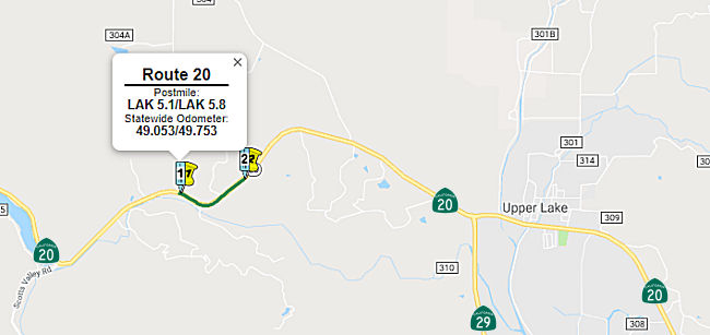 In June 2017, the CTC added the following into the SHOPP: 01-Lak-20 5.1/5.7 On Route 20:
Near Upper Lake, from 0.4 mile west to 0.2 mile east of Witter Springs
Road. Curve improvement, shoulder widening, and add left-turn pocket and
rumble strips. $234,000 (R/W) $7,441,000 (C) PA&ED: 04/08/2019 R/W:
04/01/2020 RTL: 04/15/2020 BC: 12/03/2020. It was also included in the final adopted 2018 SHOPP in March 2018: PPNO 4647. 01-Lake-20 5.1/5.7. Total Project Cost: $13,029K.
In June 2017, the CTC added the following into the SHOPP: 01-Lak-20 5.1/5.7 On Route 20:
Near Upper Lake, from 0.4 mile west to 0.2 mile east of Witter Springs
Road. Curve improvement, shoulder widening, and add left-turn pocket and
rumble strips. $234,000 (R/W) $7,441,000 (C) PA&ED: 04/08/2019 R/W:
04/01/2020 RTL: 04/15/2020 BC: 12/03/2020. It was also included in the final adopted 2018 SHOPP in March 2018: PPNO 4647. 01-Lake-20 5.1/5.7. Total Project Cost: $13,029K.
In May 2019, the CTC approved the following project for
future consideration of funding: for which a Mitigated Negative
Declaration (MND) has been completed: 01-Lak-20, PM 5.10/5.80 Route 20 in
Lake County. Widen shoulders on a portion of Route 20 near the town of
Upper Lake. (PPNO 4647). This project is located on Route 20 near Upper
Lake, east of Witter Springs Road in Lake County. The project proposes to
widen shoulders in both directions of Route 20, increase existing curve
radius and add an eastbound left turn lane and a westbound right turn
lane. This project proposes to address the frequency and severity of
collisions at this project location. The proposed project will improve the
current narrow shoulders, limited clear recovery zones, insufficient
stopping distances, non-standard curve radius and nonstandard
superelevation, as well as improve overall safety for motorists. The
project is fully funded and programmed in the 2018 State Highway Operation
Protection Program (SHOPP) for an estimated total of $13.0 million, which
includes Construction (capital and support) and Right-of-Way (capital and
support). Construction is estimated to begin in Fiscal Year 2020-21. The
scope, as described for the preferred alternative, is consistent with the
project scope programmed by the Commission in the 2018 SHOPP. The CTC also
approved the following SHOPP Amendment: 01-Lak-20 5.1/5.7 5.1/5.8
PPNO 4647. ProjID 0116000170. On Route 20 Near Upper Lake, from 0.4 mile
west to 0.2 0.3 mile east of Witter Springs Road.
Curve improvement, shoulder widening, and add left-turn pocket and rumble
strips. Note: Change in project limits is to accommodate a standard curve
radius and eliminate the need for retaining walls. Additional construction
capital is needed due to increase in earthwork quantities and increase in
unit prices for excavation. Additional R/W capital is needed due to
encroachment into a wetland area requiring additional mitigation, permits,
and temporary construction easements. Improved design also requires one
additional parcel. Total est. cost now: $14,504K. Lastly, the CTC approved
the following SHOPP Support Phase allocation: 01-Lak-20 5.1/5.8. Route 20
near Upper Lake, from 0.4 mile west to 0.3 mile east of Witter Springs
Road. Curve improvement, shoulder widening, and add left turn pocket and
rumble strips. (Concurrent consideration of funding under Resolution
E-19-36; May 2019.) (Concurrent amendment under SHOPP Amendment 18H-009.)
PPNO 4647. ProjID 0116000170. PS&E $1,877,000. R/W Sup $144,000.
(Source: May 2019 CTC Agenda Item 2.2c.(1),
2.1a.(1) Amend Item 6; Agenda Item 2.5b.(2a) Item 3)
In August 2020, the CTC amended this SHOPP project:
01-Lak-20 PM 5.1/5.8 PPNO 4647 ProjID 0116000170 EA 0G330. Route 20 Near
Upper Lake, from 0.4 mile west to 0.3 mile east of Witter Springs Road.
Curve improvement, shoulder widening, and add left-turn pocket and rumble
strips. Changes to Con Sup from $1,870K to $1,577K, and to Const Cap from
$8,316K to $8,131K. Note: Split environmental mitigation work from this
project into EA OG331/PPNO 01-4647M.
(Source: August 2020 CTC Agenda, Agenda Item
2.1a.(1d) #2)
Related to the above, in August 2020 the CTC also
approved the following financial allocation for construction and
construction support: $9,498,000 01-Lak-20 PM 5.1/5.8. PPNO 01-4647.
ProjID 0116000170 EA 0G330. Route 20 Near Upper Lake, from 0.4 mile west
to 0.3 mile east of Witter Springs Road. Outcome/Output: Improve safety by
realigning curves, widening shoulders, and constructing rumble strips.
This project will reduce the number and severity of collisions.
(Source: August 2020 CTC Agenda, Agenda Item
2.5b.(1) #5)
Route 29 W of Clear Lake to Route 53 E of Clear Lake
Morrison Creek Bridge No. 14-0004 (LAK PM 16.81)
In June 2019, the CTC approved the following SHOPP
scope amendment: 01-Lak-20 Var 9.4 PPNO 3098
ProjID 0113000122. Route 20 Near Upper Lake, at Polk Jones Cattlepass
Bridge No. 14-0034 (PM 9.41) and Morrison Creek Bridge No. 14-0004
(PM 16.81); also, on Route 29 at Manning Creek Bridge No. 14-0067
(PM R38.91). Replace and upgrade bridge rails and widen one bridge.
The need to widen Morrison Creek Bridge to provide raised pedestrian
sidewalks on both sides requires cultural analysis, resulting in a
schedule delay. Transfer the scope and associated cost and performance of
this bridge to project EA 0E081/PPNO 01-3130, which has a schedule that
aligns with this delay. Adjusted total cost: $3,775K
(Source: June 2019 CTC Minutes, Agenda Item
2.1a.(1) Scope Item 7)
In June 2019, the CTC also approved the following SHOPP
scope amendment: 01-Lak-29 50.8 PPNO 3130 ProjID 0118000172. Route 29 Near
Upper Lake, at Robinson Creek Bridge No. 14 -0030 (PM 50.82); also on
Route 175 at Kelsey Creek Bridge No. 14-0044 (PM 19.48); also on
Route 20 at Morrison Creek Bridge No. 14-0004 (PM 16.81). Widen
bridge and upgrade bridge rails at Robinson Creek Bridge and
Morrison Creek Bridge, and replace existing Kelsey Creek Bridge.
Remove Morrison Creek Bridge from project EA 0E080/PPNO 01-3098 and add to
this project. The need for cultural analysis delayed the Morrison Creek
Bridge delivery schedule and it now better aligns with this project.
Further cost increases are associated with additional piles, retaining
wall, and required environmental mitigation. Updated total cost: $10,833K.
(Source: June 2019 CTC Minutes, Agenda Item
2.1a.(1) Scope Item 11)
In August 2020, the CTC approved for future
consideration of funding a project is located on Route 20 (01-Lak-20, PM
16.81), Route 29 (01-Lak-29, PM 50.82), and Route 175 (01-Lak-175, PM
19.48) at various locations in Lake County. The Department proposes to
widen and upgrade bridge rails at Robinson Creek Bridge and Morrison
Creek Bridge, and replace existing Kelsey Creek Bridge. This project is
fully funded and is currently programmed in the 2020 State Highway
Operation Protection Program (SHOPP) for a total of $14,076,000 which
includes Construction (capital and support) and Right of Way (capital and
support). Construction is estimated to begin in Fiscal Year 2021-2022. The
scope, as described for the preferred alternative, is consistent with the
project scope programmed by the Commission in the 2020 SHOPP.
(Source: August 2020 CTC Agenda, Agenda Item
2.2c.(1))
Related to the previous item, also in August 2020 the
CTC approved the following financial allocation: $2,220,000 for PS&E;
$223,000 for R/W Support. 01-Lak-29 PM 50.8. PPNO 3130 ProjID 0118000172
EA 0E081. Route 29 Near Upper Lake, at Robinson Creek Bridge No. 14-0030
(PM 50.82); also on Route 175 at Kelsey Creek Bridge No. 14-0044 (PM
19.48); also on Route 20 at Morrison Creek Bridge No. 14-0004 (PM 16.81).
Widen bridge and upgrade bridge rails at Robinson Creek Bridge and
Morrison Creek Bridge, and replace existing Kelsey Creek Bridge.
(Source: August 2020 CTC Agenda, Agenda Item
2.5b.(2b) #1)
In March 2012, it was reported that Caltrans has begun construction of a roundabout at Nice-Lucerne Cutoff Road (~ LAK 12.138) in an attempt to improve safety.
In October 2017, the CTC approved relinquishment of right of way in the county of Lake along Route 20 at Nice-Lucerne Cutoff and Pyle Road (01-Lak-20-PM 12.2), consisting of collateral facilities. The County, by cooperative agreement dated February 152011 agreed to waive the 90-day notice requirement and accept title upon relinquishment by the State.
In January 2010, the CTC approved relinquishment of right of Way along Route 20 in the town of Nice, county of Lake, at Collier Avenue (~ LAK 12.934), consisting of a reconstructed and relocated county road..
In August 2009, the CTC approved relinquishment of right of way in the county of Lake along Route 20 just west of Route 53, consisting of a frontage road (~ LAK 31.236).
In November 2019, Caltrans reported that the
roundabout at the Route 20 / Route 53 intersection in Lake County (~ LAK
31.587) was opening to traffic. The roundabout is expected to reduce the
total number of collisions by 28% and collisions with injuries are
projected to drop 74%.
(Source: Caltrans District 1 Tweet, 11/5/2019)
Route 53 E of Clear Lake to I-5 near Williams
Clearlake Oaks to Walker Ridge Curve Realignment (01-Lak-20 R43.9/R44.2)
In August 2023, the CTC amended the 2022 SHOPP to add
the following project: 01-Lak-20 R43.9/R44.2. PPNO 01-3217; ProjID
0122000135; EA 0M310. Route 20 Near Clearlake Oaks, from 0.3 mile east to
0.6 mile east of Walker Ridge Road. Realign curve, widen shoulders,
and construct rumble strips. Concurrent COS allocation under Resolution
FP-23-16; August 2023. Allocation ($ × 1,000): PA&ED $1,592;
PS&E $1,391; R/W Sup $391; ⊘Con
Sup $1,684; ⊘R/W Cap $46; ⊘Const Cap $6,956; TOTAL $12,060.
FY23-24 through FY26-27. Begin Const: 8/24/2027.
(Source: August 2023 CTC Agenda, Agenda Item 2.2a.(1a) #41)
In August 2023, the CTC approved the following SHOPP
Pre-Construction Phase (environmental support, design, and R/W support)
allocation: $1,592,000. 01-Lak-20 R43.9/R44.2. PPNO 01-2535; ProjID
0122000135; EA 0M310. Route 20 Near Clearlake Oaks, from 0.3 mile east to
0.6 mile east of Walker Ridge Road. Realign curve, widen shoulders,
and construct rumble strips. Concurrent Amendment under SHOPP Amendment
22H-011; August 2023. Allocation: PA&ED $1,592,000.
(Source: August 2023 CTC Agenda, Agenda Item 2.5b.(2a) #3)
In May 2015, the CTC authorized relinquishment of right of way in the county of Colusa along Route 20 at Bear Valley Road (~ COL 3.343, near Wilbur Springs, near the intersection with Route 16), consisting of a reconstructed county road.
In August 2011, the CTC approved $277,000 in SHOPP funding, programmed in Fiscal Years 2012-13 and 2013-14, for repairs in Nevada, Sacramento and Yolo Counties on Route 5, Route 20 and US 50 at various locations that will upgrade crash cushions and guardrail to meet the current National Cooperative Highway Research Program (NCHRP) 350 standards and improve safety.
In August 2011, the CTC approved $8,800,000 in SHOPP funding for repairs near Williams, from 10 miles west of Williams (~ COL R12.272) to 1.5 miles east of Route 5 (~ COL R23.772), that will rehabilitate 26.2 lane miles of roadway to improve the ride quality, prevent further deterioration of the traveling surface, minimize costly roadway repairs and extend the pavement service life.
E-Streets Complete Streets Project
In December 2022, it was reported that the CTC approved
$9.3 million for the E Street Complete Streets Project in Williams. The
project addresses the intersection of E and Eleventh streets, including F
Street, where there are various conflict points for drivers due to cross
traffic and speeding, failure to stop at stop signs, collisions, and
pedestrian and bicyclist safety. To alleviate these problems, city
officials are looking to install a roundabout at the intersection. The E
Street project is still in the design phase and several design options for
the corridor are being considered with various other features including
turn lanes, bike paths, pedestrian walkways, curbs and gutters, lighting
and parking. The timeline for the project’s necessary milestones
– which includes an environmental study, possibly acquiring
property, design and bidding – will take a couple of years.
Construction will likely not begin until 2025.
(Source: Appeal Democrat, 12/16/2022)
In November 2010, it was reported that Caltrans had completed construction of the $7.1 million project at the Route 20/I-5 junction in Williams (~ COL R21.949). The project was financed by the American Recovery and Reinvestment Act of 2009. The project reconstructed and stabilized approximately two miles of embankment slopes at the junction; in addition, a mile-long safety guardrail was installed, and the highway was resurfaced to give motorists a smoother, safer ride.
I-5 near Williams to Route 70 near Yuba City
Husted Road Interchange (~ COL T23.197)
Note: Some of this discussion relates to former Route 20, on E Street in Williams.
In December 2011, it was reported that the City of
Williams is lobbying for a new truck-friendly intersection on Route 20,
between Husted Road and I-5. The goal is getting access to the highway at
what would be an extension of Margurite Street north to the highway.
Margurite currently runs north from E Street to the new Woodland Community
College facility, and dead ends at Ella, which runs east to Husted.
(Source: Colusa Sun-Times)
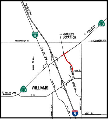 In October 2014, the CTC approved a future road connection to I-5 as part of a project related
to Route 20. The project is located approximately 2,000 feet east of the
I-5/Route 20 interchange in the City of Williams in Colusa County (~ COL
T23.197). The project will create a new public road connection between the
I-5 northbound off-ramp and Husted Road, construct improvements on Route 20 for turning movements, extend Margurite Street 3,200 feet from Ella
Street to Route 20, and install a concrete culvert and drainage for the
new segment of Margurite Street. As a result of this project the
designation of Route 20 between I-5 and Husted Road will change from
“freeway” to “controlled access expressway”.
Impacts that require mitigation measures to be reduced to a less than
significant level relate to Transportation & Traffic, Cultural
Resources, Paleontology, Air Quality, Noise, Biological Resources and
Climate Change. Mitigation measures include, but are not limited to:
preparation and implementation of a traffic management plan, monitoring
efforts for archaeological and paleontological artifacts during
construction including measures to address the inadvertent discovery of
cultural or paleontological resources, development and implementation of a
lead compliance plan, measures to reduce noise, dust and emissions from
construction equipment and operations, implementation of erosion control
and stormwater pollution prevention measures, preconstruction surveys and
establishment of buffer zones and other avoidance and compensatory
measures to minimize impacts to nesting birds, the Swainson’s Hawk,
the Burrowing Owl, and the Giant Garter Snake, and measures to minimize
the spread of invasive plant species. The project is estimated to cost
$6,860,000 and is fully funded through construction with STIP ($3,500,000)
and Local ($3,360,000) funds. Construction is estimated to begin in fiscal
year 2014/15.
In October 2014, the CTC approved a future road connection to I-5 as part of a project related
to Route 20. The project is located approximately 2,000 feet east of the
I-5/Route 20 interchange in the City of Williams in Colusa County (~ COL
T23.197). The project will create a new public road connection between the
I-5 northbound off-ramp and Husted Road, construct improvements on Route 20 for turning movements, extend Margurite Street 3,200 feet from Ella
Street to Route 20, and install a concrete culvert and drainage for the
new segment of Margurite Street. As a result of this project the
designation of Route 20 between I-5 and Husted Road will change from
“freeway” to “controlled access expressway”.
Impacts that require mitigation measures to be reduced to a less than
significant level relate to Transportation & Traffic, Cultural
Resources, Paleontology, Air Quality, Noise, Biological Resources and
Climate Change. Mitigation measures include, but are not limited to:
preparation and implementation of a traffic management plan, monitoring
efforts for archaeological and paleontological artifacts during
construction including measures to address the inadvertent discovery of
cultural or paleontological resources, development and implementation of a
lead compliance plan, measures to reduce noise, dust and emissions from
construction equipment and operations, implementation of erosion control
and stormwater pollution prevention measures, preconstruction surveys and
establishment of buffer zones and other avoidance and compensatory
measures to minimize impacts to nesting birds, the Swainson’s Hawk,
the Burrowing Owl, and the Giant Garter Snake, and measures to minimize
the spread of invasive plant species. The project is estimated to cost
$6,860,000 and is fully funded through construction with STIP ($3,500,000)
and Local ($3,360,000) funds. Construction is estimated to begin in fiscal
year 2014/15.
As part of this project, the City of Williams (City) has proposed (and the CTC approved, in December 2014) construction of a new public road connection to Route 20 at Marguerite Street between the I-5 northbound off ramp and Husted Road (~ COL R22.686). The City’s General Plan Update (GPU), adopted in June 2012, identifies this new local road intersection with Route 20. Zoning changes allow for commercial and industrial development within the zoned business park along Marguerite Street. The new connection would improve traffic circulation and facilitate economic development opportunities for the commercial and business park development in the northeast section of the City. It would also allow for expedient emergency vehicle response to the business park. This section of Route 20 is a two-lane urban route within the city’s limits and continues as a rural route to the east and west of the City. Historically, there has been little development within the city; however, commercial development has been approved for construction in the 2015 fiscal year and more is expected to occur in the near term east of I-5 near the proposed new connection. The Department’s 2013 Route 20 Transportation Concept Report calls for a four-lane expressway as the ultimate facility type for this segment of Route 20 east of I-5. In Colusa County, conversion of Route 20 east of I-5 to a freeway is not anticipated to occur within the next 20 years (e.g., before 2034). Accordingly, District 3, per letter dated May 8, 2014, requested the recategorization of Route 20 from freeway to controlled access highway. This was approved on May 13, 2014. Additionally, in 2011, District 3 reviewed the City’s traffic studies associated with the extension of Marguerite Street and its proposed connection to Route 20. District 3 did not find any evidence that their request with full build out of the land use would negatively affect traffic operations along Route 20 or I-5. According to the approved traffic studies, the Route 20 proposed T intersection at Marguerite Street would only require stop traffic signs at this time. A traffic signal will be installed if warranted in future years.
In October 2022, the draft FSTIP included the following
project: State Route 20 & Margurite Street Intersection Impro.
In the City of Williams, on Route 20 at the Margurite Street intersection.
Construct intersection control improvements (roundabout or traffic signal,
TBD). It looks like $266 (presumably, ×$1000), with $100 in FFY23 and
$166 in FFY25, all for planning and engineering.
(Source: Draft FSTIP, 10/2022)
In May 2023, the CTC was noticed of an amendment that
would move COVID Regional Improvement Funds to program funding on the
following project: State Route 20 & Margurite Street Intersection
Improvement Project. PPNO 03-3204. 03-COL-20 ~ COL R22.506. In the
City of Williams, on Route 20 at the Margurite Street intersection:
Construct intersection control improvements (roundabout or traffic signal,
TBD). Programmed funding: PS&E 166K. This funding was approved at the
June 2023 meeting.
(Source: May 2023 CTC Agenda, Agenda Item 2.1b.(1); June 2023 CTC
Agenda, Agenda Item 2.1a.(3))
In December 2016, the CTC approved for future consideration of funding a project in Colusa County that will remove and reconstruct the roadway to accommodate two 12-foot wide lanes, two 10-foot wide shoulders, new 12-foot wide turn lanes, Americans with Disabilities Act compliant sidewalks, improved drainage facilities, and other upgrades on Route 20 in the City of Colusa (03-Col-20, PM 31.8/32.8), from roughly Market and 1st to Bridge and Butte Vista Drive. The project is programmed in the 2016 State Highway Operation and Protection Program. The total programmed amount is $13,500,000 for capital and support. Construction is estimated to begin in Fiscal Year 2017-18. The scope, as described for the preferred alternative, is consistent with the project scope programmed by the Commission in the 2016 State Highway Operation and Protection Program.
In February 2006, the CTC received a report of no environmental impact for a project to rehabilitate the roadbed between Butte Vista Way in Colusa County (~ COL 32.785) to Hageman Road in Sutter County (~ SUT 2.711) between Meridian and Tarke.
In December 2005, the CTC considered relinquishment of right of way in the County of Sutter, between Hageman Road (~ SUT 2.711) and West Butte Road (~ SUT 5.014), consisting of reconstructed and relocated county roads, frontage roads, cul-de-sacs, and a bridge.
In August 2005, the CTC considered vacation of the right of way in the County of Sutter, between North Tarke Road (~ SUT 4.217) and West Butte Road (~ SUT 5.014), consisting of highway right of way easement no longer needed for State highway purposes.
In March 2017, the CTC approved for future consideration of funding a project located in Sutter County that proposes to rehabilitate pavement and widen shoulders on Route 20 (03-Sut-20, PM 5.0/11.3). In addition, the Wadsworth Canal Bridge No. 18-0003 will be replaced. The proposed project will meet current design standards and extend its service life. This project is programmed in the 2016 SHOPP for $30,765,000 in Construction (capital and support) and Right of Way (capital and support). Construction is estimated to beginning in Fiscal Year 2017-18. The scope, as described for the preferred alternative, is consistent with the project scope programmed by the Commission in the 2016 State Highway Operation and Protection Program.
In June 2016, it was reported that Caltrans held an open house to discuss
improvement plans for a section of Route 20 in Sutter County west of Yuba
City. Major improvements on the $25 million Sutter bypass project, a 6.3
mile section of Route 20 between West Butte Road (~ SUT 5.014) and Lytle
Road (~ SUT 11.368), includes realigning the highway at Wadsworth Canal,
removing and demolishing the existing Wadsworth Canal Bridge and building
a new one just north of the existing site, and widening the shoulders
along the Route 20 to accommodate a bike route.
(Source: Appeal-Democrat, 6/17/2016)
In December 2011, the CTC approved for future consideration of funding a project in Sutter County that will construct a new public road connection to Route 20 at Western Parkway (~ SUT 13.082) between Township Road and George Washington Boulevard in Yuba City. The project is entirely funded with local dollars. The project will need an approval for a new public road connection from the Commission. The total estimated cost is $2,570,000. Construction is estimated to begin in Fiscal Year 2010-11. The project will mitigate potential impacts to water quality/storm water runoff to a less than significant level. Water quality impacts will be mitigated through implementation of BMPs. The City of Yuba City is the CEQA lead agency for the project and all mitigation measures are the responsibility of Yuba City.
Dry Creek Bridge (03-Yub-20, PM 13.30/R17.80)
In January 2018, the CTC approved for future
consideration of funding the following project for which a Mitigated
Negative Declaration (MND) has been completed: Route 20 (03-Yub-20, PM
13.30/R17.80) in Yuba County: Construct roadway improvements and replace
an existing bridge on Route 20 near the city of Marysville. (PPNO 9579)
The project is located east of the city of Marysville, from Marysville
Road to the Yuba River and proposes to widen shoulders, realign a portion
of Route 20 and replace Dry Creek Bridge (Bridge No. 16-0010). This
project is intended to bring the highway alignment up to current design
standards and extend the service life of the pavement. Also, replacing the
Dry Creek Bridge will allow Route 20 to have full permit loads for
vehicles traveling from Marysville to Grass Valley. The project is
programmed in the 2016 SHOPP and is estimated to cost $45 million.
Construction is estimated to begin in Fiscal Year 2020-21. The scope, as
described for the preferred alternative, is consistent with the project
scope programmed by the Commission in the 2016 SHOPP.
(Source: CTC Agenda, January 2018, Agenda Item
2.2c(1))
In September 2021, it was reported that traffic has
been shifted to the newly constructed Dry Creek Bridge on Route 20 in the
Browns Valley area of Yuba County. The traffic shift allows the contractor
to start demolishing the old bridge before the rainy season begins. In the
meantime, crews are scheduled to begin major paving work along the Route 20 corridor between Marysville Road and the Parks Bar Bridge.
(Source: Lake County News, 9/24/2021)
In October 2022, it was reported that after more than
two years of construction, the Dry Creek Bridge renovation project in Yuba
County has been completed. Officials with Caltrans held a ribbon cutting
ceremony in early October 2022 to commemorate the completion of the
project on Highway 20 in Browns Valley, along with other road projects
that concurrently developed. The Browns Valley project is the last of five
major projects to be completed along Route 20. The five-mile section
between Marysville Road and Timbuctoo Place was renovated and
rehabilitated in order to provide wider lanes and shoulders to give
commercial and recreational drivers more space to travel and pull off from
the road. Other renovations include long-lasting, smoother pavement,
upgraded facility standards, truck climbing walls, a wildlife
undercrossing and increased sight distance for motorists. A turning lane
was also added near the bridge to allow for safer ingress and egress into
the road. The $65.5 million dollar project included nearly $5 million in
funding from the 2017 Road Repair and Accountability Act.
(Source: Yahoo!News/Appeal Democrat, 10/7/2022)
Roadway Improvements near Lower Smartsville Road (03-YUB-20 R18.0/20.3)
In January 2018, the CTC approved for future
consideration of funding the following project for which a Mitigated
Negative Declaration (MND) has been completed: Route 20 (03-Yub-20, PM
R18.07/20.25) in Yuba County: Construct roadway improvements on a portion
of Route 20 near the town of Smartsville. (PPNO 9590). The project is
located near the town of Smartsville along Route 20 in Yuba County. The
project proposes to improve the roadway’s horizontal and vertical
alignment, widen shoulders and add turn pockets from the Yuba River Bridge
to the east of Lower Smartsville Road. The project is fully funded and
programmed in the 2016 SHOPP for an estimated total of $67.3 million,
which includes Construction (capital and support) and Right-of-Way
(capital and support). Construction is estimated to begin in Fiscal Year
2020-21. The scope, as described for the preferred alternative, is
consistent with the project scope programmed by the Commission in the 2016
SHOPP.
(Source: CTC Agenda, January 2018, Agenda Item
2.2c(1))
The following project was included in the final adopted 2018 SHOPP in March 2018: PPNO 9590. 03-Yuba-20 R18.0/20.3. Route 20 Near Smartsville, from the Yuba River Bridge to east of Smartsville Road. Realign and widen roadway. Begin Con: 12/1/2019. Total Project Cost: $67,321K.
In June 2019, the CTC approved following construction
allocation: $61,678,000 03-Yuba-20 R18.1/20.1 ProjID 0313000020. Route 20
Near Smartsville, from the Yuba River Bridge to 0.1 mile east of
Smartville Road. Realign roadway, provide standard shoulders, extend
existing eastbound truck climbing lane, and add left turn lanes. This
project will reduce the number and severity of collisions. Const.
$54,678,000 Const. Engr. $7,000,000
(Source: June 2019 CTC Minutes, Agenda Item
2.5b.(1) Item 9)
In November 2020, it was reported that crews from
Flatiron Construction are making significant progress on the $54 million
Route 20 Timbuctoo Roadway Project taking place a half-mile east of the
Yuba River in eastern Yuba County, Calif. The project, financed by state
and federal dollars, began in February 2020, with delivery anticipated in
September 2021. Flatiron is ahead of schedule with a projected winter 2021
final construction. The initiative is upgrading a 2-mi. section of Route 20 from the Yuba River Bridge to approximately 1/3-mi. east of Smartsville
Road, as well as straightening curves on a section of the highway,
widening segments of highway to create uniform 12-ft. wide lanes and
shoulders to a standard 8-ft. width, constructing a new bridge on the
realigned section of highway and increasing sight distances for motorists
traveling on the highway. In essence, the current two-lane highway, in an
isolated hilly area with forests on either side and power lines and
electrical infrastructure on both sides, is being widened by one lane in
each direction with shoulders and intermittent passing lanes. The primary
challenges have been the topography and site geology. Large amounts of
hard rock were encountered that required controlled blasting to be
conducted. The design and construction needed to balance the roadway
geometrics with environmental, land use and physical constraints. Roadways
are designed with a 50-year life, structures are built for 100 plus year
life. The construction is one of the first in the state to heavily utilize
unmanned aerial systems [UAS] for the inspection and measurements of
earthwork. The structure design is a standard cast-in-place box girder
structure. This design minimizes construction costs and maintenance over
the life of the structure. Approximately 280,000 cu yds. of rock and earth
have been removed, with approximately one-third of that quantity requiring
blasting. All of the material has been utilized on-site for the embankment
construction. There has also been construction of an 800 ft. long and 60
ft. wide bridge, with one lane in each direction, with an additional
passing lane in the East uphill direction. Bridge construction began in
early May with 96-in. diameter cast-in driven holes (CIDH), some shafts
being as deep as 90 ft. and others as shallow as 30 ft. Drainage upgrades
are an important part of the work for the stretch of highway in which some
components were last updated in 1939.
(Source: Construction Equipment Guide, 11/4/2020)
In June 2007, the CTC considered a request from Yuba City for a new roadway connection at Harter Parkway (~ SUT 14.474), due to projected growth and congestion in the vicinity of the Harter Parkway connection. Yuba City is proposing to convert this existing connection to Route 20 to a full four-way intersection to relieve local traffic congestion and support planned development and growth in the area. A commercial development of 35 acres will start construction in 2007 immediately south of this intersection. This section of Route 20 is a four-lane expressway with 8-foot outside shoulders. The highway has a paved median for about 500 feet west of Harter Parkway and an unpaved median for the rest of this corridor. Within the limits of Yuba City there are a number of intersections along Route 20. Numerous driveways have been constructed using encroachment permits. Harter Parkway is connected to Route 20 from the north. On the south side of the intersection, only a private drive connection has been maintained.
Route 70 near Yuba City to Route 49 near Grass Valley
In December 2011, Caltrans completed emergency repairs on the 10th Street Bridge over the Feather River (~ YUB 0.005). The seven-month, $12 million project strengthened two of the 23 piers that support the 64-year-old bridge and added new erosion protection for three other piers. The emergency work ensures the four-lane span linking the twin cities of Yuba City and Marysville will withstand heavy river flows in the future. During an inspection in March 2011, Caltrans bridge engineers discovered emergency scour conditions existed on the bridge. High water flows over the years caused 19 feet of erosion to one the pier footings. An adjacent pier also was deemed “at risk” in a high-water event. Emergency repairs were launched June 1, 2011. Construction crews drove 20 new steel piles as deep as 185 feet into the river bed to strengthen two footings and placed 8,000 cubic yards of 500- to 1,000-pound boulders (known as riprap) to protect three other piers from erosion. The project also used 2,200 cubic yards of concrete and 3,000 linear feet of 48-inch diameter steel pipe.
In August 2011, the CTC approved for future consideration of funding a project that will rehabilitate the route in the city of Marysville (~ YUB 0.944), including new pavement, curb ramps, and sidewalks. The CTC also approved $41,500,000 in SHOPP funding for repairs in Marysville, from First Street Undercrossing to east of Binney Junction; also on Route 20 from Feather River Bridge to 0.1 mile east of Levee Road, that will rehabilitate 17.0 lane miles of roadway to improve the ride quality, prevent further deterioration of the road surface, minimize the costly roadway repairs and extend the pavement service life.
In August 2016, the CTC approved for future consideration of funding a project on Route 20 (03-Yub-20, PM 8.0/10.2) in Yuba County that will rehabilitate the roadway and widen shoulders on a portion of Route 20 near the City of Marysville. The project is programmed in the 2016 State Highway Operation and Protection Program. The total programmed amount is $5,120,000 for capital and support. Construction is estimated to begin in Fiscal Year 2018-19. The scope, as described for the preferred alternative, is consistent with the project scope programmed by the Commission in the 2016 State Highway Operation and Protection Program.
In December 2017, the CTC amended the following project in the SHOPP: 03-YUB-20 R18.0/20.3: On Route 20 in Yuba County: Near Smartsville, from the Yuba River Bridge to east of Smartsville Road. Realign and widen roadway
In March 2016, the CTC approved for future consideration of funding a project in Yuba and Nevada Counties that will realign curves and improve shoulders on Route 20 near the community of Lake Wildwood (~ NEV R4.704). The project is programmed in the State Highway Operation and Protection Program. The total estimated cost is $25,370,000 for capital and support. Construction is estimated to begin in Fiscal Year 2017-18. The scope, as described for the preferred alternative, is consistent with the project scope programmed by the Commission in the 2014 State Highway Operation and Protection Program. A copy of the MND has been provided to Commission staff. The project will result in less than significant impacts to the environment after mitigation. The following resource areas may be impacted by the project: cultural resources, and biological resources. Avoidance and minimization measures will reduce any potential effects on the environment. These measures include, but are not limited to, data recovery protocol to be followed for any archeological resources found on the project site, replacement trees to be planted in the project right-of-way where feasible, disturbed riparian habitat to be mitigated through on-site restoration, and a wildlife undercrossing to be constructed for wildlife migration. As a result, an MND was completed for this project.
In June 2021, the CTC authorized relinquishment of right-of-way,
consisting of two segments of collateral facilities in the county of
Nevada along Route 20 on Deadman’s Flat Road and South Ponderosa Way
(3-Nev-20-PM R9.9/R10.1), under the terms and conditions as stated in
Resolution No. 21-020 dated January 26, 2021. The County, by letter
dated April 21, 2021, agreed to waive the 90-day notice requirement and
accept title upon relinquishment by the State.
(Source: June 2021 CTC Agenda, Agenda Item 2.3c)
The segments within Grass Valley (03-Nev-174-PM 9.6/10.2, 03-Nev-20-PM
12.9/13.3) were relinquished in August 2022, when the CTC authorized
relinquishment of right of way in the city of Grass Valley along Route 174
(Colfax Avenue) from Route 20 to Race Street, along Route 20 on Tinloy
Street from South Auburn Street to Bank Street, on Hansen Way from Colfax
Avenue to East Bennett Street, and along Neal Street and South Auburn
Street, under the terms and conditions as stated in the relinquishment
agreement dated October 13, 2021 and determined to be in the best interest
of the State. The relinquishment was authorized by Chapter 82,
Statutes of 2020, which amended Section 474 of the Streets and Highways
Code.
(Source: August 2022 CTC Agenda, Agenda Item 2.3c)
Route 49 near Grass Valley/Nevada City to I-80 near Yuba Pass
Dorsey Drive (~ NEV R14.358)
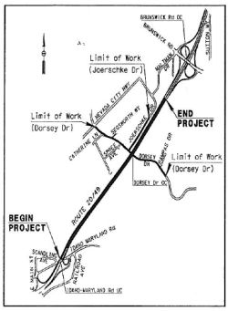 In May 2008, the CTC considered approval for future consideration of funding roadway
improvements on a portion of Route 20 near Grass Valley for which a
Mitigated Negative Declaration (MND) has been completed. The project will
involve the removal of mature oak trees and construction activities in the
U.S. Army Corps of Engineers jurisdictional wetlands. The approximate
boundaries are Idaho-Maryland Road and Brunswick Road. The project will
include adding an interchange to Route 20 at Dorsey Drive. Specifically,
the Nevada County Transportation Commission (NCTC) is proposing to replace
the existing Dorsey Drive overcrossing with a full interchange to address
operational problems at adjacent interchanges (Idaho-Maryland Road and
Brunswick Road) as well as at the local surface streets of East Main
Street and the Nevada City Highway. The primary purpose for this project
is to reduce local traffic burden thereby creating additional capacity for
future development. This new interchange will also provide more direct
access to the specific high use sites of Sierra Nevada Memorial Hospital
and the Sierra College Nevada County Campus. In the vicinity of the
proposed Dorsey Drive interchange, Route 20 is a four-lane divided
freeway. It was constructed in the late 1960's and is located in the
western foothills of the Sierra Nevada Range and within the urbanized area
of the City of Grass Valley. Route 20 is a major arterial for the City of
Grass Valley and Nevada City. Dorsey Drive overcrossing is currently a
two-lane collector, constructed in 1960. The proposed project will replace
the overcrossing with a five-lane wide structure (including a turning
lane) on a full compact diamond interchange. The interchange will be
located approximately 0.64 mile east of the Idaho-Maryland Road
interchange and approximately 0.53 mile west of Brunswick Road
interchange. The project will also include the construction of auxiliary
lanes between the proposed Dorsey Drive interchange and both adjacent
interchanges to mitigate merging conflicts caused by nonstandard spacing.
A Project Study Report for this project was approved on December 6, 1994.
The Project Report was approved on June 30, 2006, and a Supplemental
Project Report was approved on February 5, 2008. The compact diamond
interchange alternative was selected and has been accepted by the NCTC and
the City of Grass Valley. In order to construct this project, Commission
approval is required for the new public road connection to Route 20 at
Dorsey Drive. At the completion of the project, it is proposed that the
local road be relinquished to the City of Grass Valley. The 2008
construction capital cost estimate is $18.8 million and right of way
capital cost is estimated at $3.0 million. The project is programmed for
$16.6 million in the 2008 State Transportation Improvement Program in
Fiscal Year 2009-10. Additional local funding will come from regional
Traffic Mitigation Fees and local sales tax funds.
In May 2008, the CTC considered approval for future consideration of funding roadway
improvements on a portion of Route 20 near Grass Valley for which a
Mitigated Negative Declaration (MND) has been completed. The project will
involve the removal of mature oak trees and construction activities in the
U.S. Army Corps of Engineers jurisdictional wetlands. The approximate
boundaries are Idaho-Maryland Road and Brunswick Road. The project will
include adding an interchange to Route 20 at Dorsey Drive. Specifically,
the Nevada County Transportation Commission (NCTC) is proposing to replace
the existing Dorsey Drive overcrossing with a full interchange to address
operational problems at adjacent interchanges (Idaho-Maryland Road and
Brunswick Road) as well as at the local surface streets of East Main
Street and the Nevada City Highway. The primary purpose for this project
is to reduce local traffic burden thereby creating additional capacity for
future development. This new interchange will also provide more direct
access to the specific high use sites of Sierra Nevada Memorial Hospital
and the Sierra College Nevada County Campus. In the vicinity of the
proposed Dorsey Drive interchange, Route 20 is a four-lane divided
freeway. It was constructed in the late 1960's and is located in the
western foothills of the Sierra Nevada Range and within the urbanized area
of the City of Grass Valley. Route 20 is a major arterial for the City of
Grass Valley and Nevada City. Dorsey Drive overcrossing is currently a
two-lane collector, constructed in 1960. The proposed project will replace
the overcrossing with a five-lane wide structure (including a turning
lane) on a full compact diamond interchange. The interchange will be
located approximately 0.64 mile east of the Idaho-Maryland Road
interchange and approximately 0.53 mile west of Brunswick Road
interchange. The project will also include the construction of auxiliary
lanes between the proposed Dorsey Drive interchange and both adjacent
interchanges to mitigate merging conflicts caused by nonstandard spacing.
A Project Study Report for this project was approved on December 6, 1994.
The Project Report was approved on June 30, 2006, and a Supplemental
Project Report was approved on February 5, 2008. The compact diamond
interchange alternative was selected and has been accepted by the NCTC and
the City of Grass Valley. In order to construct this project, Commission
approval is required for the new public road connection to Route 20 at
Dorsey Drive. At the completion of the project, it is proposed that the
local road be relinquished to the City of Grass Valley. The 2008
construction capital cost estimate is $18.8 million and right of way
capital cost is estimated at $3.0 million. The project is programmed for
$16.6 million in the 2008 State Transportation Improvement Program in
Fiscal Year 2009-10. Additional local funding will come from regional
Traffic Mitigation Fees and local sales tax funds.
In August 2012, the CTC approved $14,155,000 in SHOPP funding for the Dorsey Drive Interchange (Phase 1). This is to fund construction of the interchange. Phase 1 portion includes southbound ramp and all right of way.
Groundbreaking for the $15 million Dorsey Drive
Interchange took place on April 29, 2013. The two-phase project widened
Dorsey Drive to five lanes and improved 1.4 miles of SR 20/49. Aesthetic
enhancements were added to concrete bridge walls, railings and street
lighting. 1,272 linear feet of sound walls matching the project color
scheme were installed as well.
(Source: AARoads Route 49 South. See page for specific references.)
Curve Improvements Near White Cloud Campground (03-Nev-20 29.7/30.9)
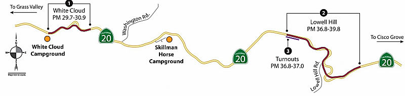 In June 2017, the CTC added the following to the SHOPP:
03-Nev-20 29.7/30.9 On Route 20: Near Nevada City, from 0.1 mile east of
White Cloud Campground to 0.9 mile west of Washington Road. Curve
improvement, shoulder widening and improve clear recovery zone. $613K
(R/W) $8,237K (C) $3,649K (Support) PA&ED: 02/01/2019 R/W: 05/01/2020
RTL: 05/01/2020 BC: 11/01/2020
In June 2017, the CTC added the following to the SHOPP:
03-Nev-20 29.7/30.9 On Route 20: Near Nevada City, from 0.1 mile east of
White Cloud Campground to 0.9 mile west of Washington Road. Curve
improvement, shoulder widening and improve clear recovery zone. $613K
(R/W) $8,237K (C) $3,649K (Support) PA&ED: 02/01/2019 R/W: 05/01/2020
RTL: 05/01/2020 BC: 11/01/2020
In June 2019, the CTC approved the following SHOPP
scope amendment: 03-Nev-20 29.7/30.9 PPNO 3994 ProjID 0315000116. Route 20
Near Nevada City, from 0.1 mile east of White Cloud Campground to 0.9 mile
west of Washington Road. Curve improvement, shoulder widening and improve
clear recovery zone. Due to the presence of archaeological sites and
prehistoric cultural resources, additional environmental studies and
coordination with United States Forest Service are required, resulting in
a delay of the project.. Completion pushed back to FY20-21.
(Source: June 2019 CTC Minutes, Agenda Item
2.1a.(1) Scope Item 28)
In January 2020, it was reported that Caltrans was
hosting an open house in February to seek community comments about a
proposed safety improvement project on Route 20 in Nevada County. Caltrans
proposes to improve highway safety by modifying the alignment of two
non-contiguous segments of the highway and adding turnouts. The $55.3
million project calls for updating these roadway segments to current
standards by increasing the curve radii, widening shoulders to eight feet,
adding turnouts in both directions and improving the vertical profile
grade. Additionally, the project will widen an existing turnout to
standard width. Construction is estimated to start in fall 2021.
(Source: YubaNet.Com, 2/9/2020)
The 2020 SHOPP, approved in May 2020, included the
following Collision Reduction item of interest (carried over from the 2018
SHOPP): 03-Nevada-20 PM 29.7/30.9 PPNO 3994 Proj ID 0315000116 EA 0H240.
Route 20 near Nevada City, from 0.1 mile east of White Cloud Campground to
0.9 mile west of Washington Road. Curve improvement, shoulder widening and
improve clear recovery zone. Programmed in FY21-22, with construction
scheduled to start in October 2021. Total project cost is $12,499K, with
$8,850K being capital (const and right of way) and $3,649K being support
(engineering, environmental, etc.).
(Source: 2020 Approved SHOPP a/o May 2020)
In June 2020, the CTC approved for future consideration
of funding the Omega Curves Project, which will improve two
non-contiguous segments of Route 20 in Nevada County. (EA 03-2H62U)
Specifically, the project proposes to improve two non-contiguous segments
of the alignment by modifying the existing horizontal and vertical curves
of the roadway and adding turnouts. The project will update the roadway to
current standards by increasing the curve radii, widening shoulders to 8
feet, adding turnouts for both directions, and improving the vertical
profile grade. It is comprised of three smaller SHOPP
projects, two of which are safety projects (EA 03-0H240, 03-2H620)
intended to reduce collisions while the third project is an operational
improvement project (EA 03-1H810) to widen the existing turnout. These
projects are fully funded and are currently programmed in the 2018 SHOPP.
Project EA 0H240 is programmed for $12,499,000 for capital and support.
Project EA 2H620 is programmed for $39,480,000 for capital and support and
Project EA 1H810 is programmed for $3,340,000 for capital and support.
Construction is estimated to begin 2021-22. The scope, as described for
the preferred alternative, is consistent with the project scopes
programmed by the Commission in the 2018 SHOPP.
(Source: June 2020 CTC Agenda, Agenda Item
2.2c.(1))
In June 2020, the CTC approved the following support
allocation for this project: 03-Nev-20 29.7/30.9. PPNO 3994 ProjID
0315000116 EA 0H240. Route 20 near Nevada City, from 0.1 mile east of
White Cloud Campground to 0.9 mile west of Washington Road. Curve
improvement, shoulder widening and improve clear recovery zone.
Allocation: PS&E $976,000; R/W Sup $291,000.
(Source: June 2020 CTC Agenda, Agenda Item
2.5b.(2a) #7)
In June 2021, the CTC approved the following
allocation: $10,200,000. 03-Nev-20 29.7/30.9. PPNO 03-3994; ProjID
0315000116; EA 0H240. Route 20: Near Nevada City, from 0.1 mile east of
White Cloud Campground to 0.9 mile west of Washington Road.
Outcome/Output: Improve safety by realigning curves, widening
shoulders, adding turnouts, and improving clear recovery zone.
This project will reduce number and severity of collisions. (Future
consideration of funding approved under Resolution E-20-45; June 2020.)
(EA 0H240/PPNO 03-3994 combined with EA 0H660/PPNO 03-3996, EA 1H810/PPNO
03-3999, and EA 2H620/PPNO 03-4000 for construction under EA 2H62U/Project
ID 0319000021.) Allocation (including use of savings from preliminary
phases): CON ENG $1,286,000 CONST $8,237,000.
(Source: June 2021 CTC Agenda, Agenda Item 2.5b.(1)
#7)
In March 2022, it was reported that Granite has been
selected for the Route 20 Omega Curve Realignment project in Nevada
County, California. The $32 million contract was awarded by Caltrans and
funded by State and Federal aid. This project realigns two existing curves
along Route 20, a high-traffic area with many accidents, and will create a
safer passage for the traveling public in Nevada County. It is a large
earthwork project, running through steep terrain of the Tahoe National
Forest.
(Source: Business Wire, 3/9/2022)
In September 2023, it was reported that Caltrans was
planning a 12-day closure of Route 20 east of Nevada City for major
roadwork on the Omega Curves Project. The first closure would take place
in the Lowell Hill segment between the Omega Overlook and Bear Valley.
Crews then will move the closure location west to the White Cloud segment
between the White Cloud U.S. Forest Service and Campground and Washington
Road. During the closure construction crews will perform grading and
paving work to construct tie-in locations to divert the traveling public
from the current roadway to the new alignment. The work is part of the
$62.5 million Omega Curves project, which will improve safety and reduce
collisions on Route 20 by realigning curves on two non-contiguous segments
near White Cloud and Lowell Hill, widening shoulders, improving the
highway’s sight distance, and adding designated left-turn lanes near
Conservation Road and Washington Road. In addition, three turnouts will be
added where slow-moving vehicles can allow motorists to safely pass, while
also serving as traffic-enforcement locations for the CHP. In October
2023, it was reported that Caltrans announced that it has finished its
project between the I-80 interchange and Grass Valley. The goal of the
project was to improve safety and reduce collisions by realigning curves
near White Cloud and Lowell Hill, which is east of Nevada City. The
construction is part of a $65 million project labeled “Omega
Curves.”
(Source: Yubanet, 9/11/2023; Fox 40 News, 10/7/2023)
In December 2023, it was reported that Caltrans was
working on finishing touches of the project and installing the animal
crossing fence. The project will improve safety and reduce collisions on
Route 20 by realigning curves on two non-contiguous segments near White
Cloud and Lowell Hill, widening shoulders, improving the highway’s
sight distance, and adding designated left-turn lanes near Conservation
Road and Washington Road. In addition, three turnouts are being
constructed so that slow-moving vehicles can allow motorists to safely
pass, while also serving as traffic-enforcement locations for the
California Highway Patrol.
(Source: Yubanet, 12/4/2023)
Excelsior Point Road/Zeibright Road Curve Improvements (03-Nev-20 37.1/39.8)
In August 2017, the CTC added the following to the SHOPP: 03-Nev-20 37.1/39.8 Route 20: Near Emigrant Gap, from 0.3 mile west of Excelsior Point Road to 1.3 mile west of Zeibright Road. Curve improvement and widen shoulders. $1,380K (R/W) $27,480K (C) $10,620K (Support) PA&ED: 02/01/2019R/W: 04/15/2020RTL: 05/15/2020BC: 11/15/2020
In June 2019, the CTC approved the following SHOPP
scope amendment: 03-Nev-20 37.1/39.8 PPNO 4000. ProjID 0317000165. Route 20 Near Emigrant Gap, from 0.3 mile west of Excelsior Point Road to 1.3
mile west of Zeibright Road. Curve improvement and widen shoulders. Due to
the presence of archaeological sites and prehistoric cultural resources,
additional environmental studies and coordination with United States
Forest Service are required, resulting in delaying the project. Completion
pushed back to FY20-21
(Source: June 2019 CTC Minutes, Agenda Item
2.1a.(1) Scope Item 29)
The 2020 SHOPP, approved in May 2020, included the
following Collision Reduction item of interest (carried over from the 2018
SHOPP): 03-Nevada-20 PM 37.1/39.8 PPNO 4000 Proj ID 0317000165 EA 2H620.
Route 20 near Emigrant Gap, from 0.3 mile west of Excelsior Point Road to
1.3 mile west of Zeibright Road. Curve improvement and widen shoulders.
Programmed in FY21-22, with construction scheduled to start in October
2021. Total project cost is $39,480K, with $28,860K being capital (const
and right of way) and $10,620K being support (engineering, environmental,
etc.).
(Source: 2020 Approved SHOPP a/o May 2020)
In June 2020, the CTC approved the following support
allocation for this project: 03-Nev-20 37.1/39.8. PPNO 4000 ProjID
0317000165 EA 2H620. Route 20 near Emigrant Gap, from 0.3 mile west
of Excelsior Point Road to 1.3 mile west of Zeibright Road. Curve
improvement and widen shoulders. Allocation: PS&E $2,810,000; R/W Sup
$410,000. (Concurrent consideration of funding under Resolution E-20-45;
June 2020.) (Sixteen month time extension for PS&E and R/W Sup
approved under Waiver 19-29; June 2019.)
(Source: June 2020 CTC Agenda, Agenda Item
2.5b.(2a) #9)
In June 2021, the CTC approved the following
allocation: $32,370,000. 03-Nev-20 37.1/39.8. PPNO 03-4000; ProjID
0317000165; EA 2H620. Route 20 Near Emigrant Gap, from 0.3 mile west of
Excelsior Point Road to 1.2 miles west of Zeibright Road. Outcome/Output:
Improve safety by realigning curves and widening shoulders, and construct
two animal crossings. This project will reduce the number and severity of
collisions. (Future consideration of funding approved under Resolution
E-20-45; June 2020.) (EA 2H620/PPNO 03-4000 combined with EA 0H240/PPNO
03-3994, EA 1H810/PPNO 03-3999, and EA 0H660/PPNO 03-3996 for construction
under EA 2H62U/Project ID 0319000021.) Allocation (including use of
savings from preliminary phases):CON ENG $3,480,000 CONST $27,480,000.
(Source: June 2021 CTC Agenda, Agenda Item 2.5b.(1)
#9)
 Naming
The portion of this route from US 101 N of Ukiah to I-80 near Emigrant Gap (~MEN 33.374 to NEV 45.374) has historically been named the "Tahoe-Ukiah Highway".
The portion of this route from Route 53 to Route 16 (~ LAK 31.384 to COL 3.304) was named the "Yolo and Lake Highway" by Resolution Chapter 283 in 1915. It was named by location.
The portion of Route 20 in Colusa County (~ COL 0.000 to COL R39.303) is designated as part of the National Purple Heart Trail in order to honor the men and women who have been wounded or killed in combat while serving in the United States Armed Forces. Additionally, the County of Colusa Veterans Tribute Wall was erected and dedicated on Veterans Day 2014 to recognize the honorable service and sacrifices made by all veterans who have lived, or do now reside, in the County of Colusa; it is located at the junction of Route 20 and Route 45, and is accessible via all state highways within the County of Colusa. Designed by Assembly Concurrent Resolution (ACR) 191, Res. Chapter 163, Statutes of 2016, on September 1, 2016.
This route is Colusa Avenue in Yuba City (~ SUT R15.549 to SUT 17.05).
The portion of Route 20 from YUB 0.000 to YUB R3.389 and Route 70 from YUB 13.604 to YUB 15.850 in the City of Marysville in the County of Yuba is designated as part of the National Purple Heart Trail. The resolution designating these segments noted that the Marysville Veterans Memorial Center is located on the west side of Route 70 in the City of Marysville and is the home of the Marysville Veterans of Foreign Wars Post 948 and the Veterans Memorial Wall for Purple Heart Recipients, Veterans, and Honoring Pearl Harbor. It also noted that the historic Marysville Cemetery is located on the east side of Route 70 in the City of Marysville and is the final resting place of approximately 104 veterans, some of whom are Purple Heart recipients, from all wars fought by the United States beginning with the Mexican-American War. Lastly, it noted that the Marysville Veterans of Foreign Wars Post 948 wished to continue the National Purple Heart Trail through the City of Marysville on Route 20 and Route 70; and that Senior Vice Commander Brock Bowen of the Marysville Veterans of Foreign Wars Post 948 took the initiative to bring the National Purple Heart Trail through the City of Marysville. Designed by Assembly Resolution ACR 19, Res. Chapter 106, Statutes of 2021, on September 7, 2021
 The portion of Route 20 between the
intersection of the Rough and Ready Highway and Penn Valley Drive and its
junction with Route 49 (~ NEV R6.568 to NEV R12.16), in Nevada County is
named the "Eric W. Rood Memorial Expressway". This segment was
named in honor of Eric W. Rood, a California native who graduated from
California State University at Sacramento, and furthered his education by
receiving a master's degree in management from George Washington
University. He also graduated from the Air War College and Harvard
Business School. Rood enlisted in the United States Air Force in 1942. He
earned his wings and commission in mid-1943 and went on to complete an
honorable tour of military service. Thereafter, he taught at the
Bombardier School at Mather Air Force Base near Sacramento before being
deployed to the Philippines for three years. He retired from the Air Force
as a colonel in 1973 at McClellan Air Force Base. While stationed with the
Pentagon, he played a role in bringing a missile program to Beale Air
Force Base. Rood served as Nevada County's 4th District Supervisor from
1975 to 1986, inclusive, including two terms as chair. As Supervisor, Rood
was instrumental in securing state funding for the Route 20 bypass between
Grass Valley and Penn Valley. Today, the highway is a busy thoroughfare
that has been critical to growth andeconomic development in Penn Valley.
Rood also worked with the state for more than two decades to resolve the
many special problems faced by the rural communities of Nevada County.
While serving as a county supervisor, Rood was president of the state's
powerful Regional Council of Rural Counties, director of the County
Supervisor's Association of California, vice chairman of the California
Local Agency Formation Commission, and served on the board of the Sierra
Economic Development District, the Sierra Planning Organization, and the
Foothill Strategy Advisory Committee. He also served on the Nevada County
local agency formation commission, the Golden Chain Council of the Mother
Lode, the Foothill Airport Land Use Commission, Mountain County Air Basin,
the Area 4 Agency on Aging, and the Foothill Strategy Advisory Committee.
He was a founder of the Western Gateway Recreation and Park District that
helped build Western Gateway Park in Penn Valley and he was also a member
of various other organizations Eric W. Rood retired in January 1987 and
passed away in 1998. Named by Assembly Concurrant Resolution (ACR) 122,
6/2/2010, Resolution Chapter 32.
The portion of Route 20 between the
intersection of the Rough and Ready Highway and Penn Valley Drive and its
junction with Route 49 (~ NEV R6.568 to NEV R12.16), in Nevada County is
named the "Eric W. Rood Memorial Expressway". This segment was
named in honor of Eric W. Rood, a California native who graduated from
California State University at Sacramento, and furthered his education by
receiving a master's degree in management from George Washington
University. He also graduated from the Air War College and Harvard
Business School. Rood enlisted in the United States Air Force in 1942. He
earned his wings and commission in mid-1943 and went on to complete an
honorable tour of military service. Thereafter, he taught at the
Bombardier School at Mather Air Force Base near Sacramento before being
deployed to the Philippines for three years. He retired from the Air Force
as a colonel in 1973 at McClellan Air Force Base. While stationed with the
Pentagon, he played a role in bringing a missile program to Beale Air
Force Base. Rood served as Nevada County's 4th District Supervisor from
1975 to 1986, inclusive, including two terms as chair. As Supervisor, Rood
was instrumental in securing state funding for the Route 20 bypass between
Grass Valley and Penn Valley. Today, the highway is a busy thoroughfare
that has been critical to growth andeconomic development in Penn Valley.
Rood also worked with the state for more than two decades to resolve the
many special problems faced by the rural communities of Nevada County.
While serving as a county supervisor, Rood was president of the state's
powerful Regional Council of Rural Counties, director of the County
Supervisor's Association of California, vice chairman of the California
Local Agency Formation Commission, and served on the board of the Sierra
Economic Development District, the Sierra Planning Organization, and the
Foothill Strategy Advisory Committee. He also served on the Nevada County
local agency formation commission, the Golden Chain Council of the Mother
Lode, the Foothill Airport Land Use Commission, Mountain County Air Basin,
the Area 4 Agency on Aging, and the Foothill Strategy Advisory Committee.
He was a founder of the Western Gateway Recreation and Park District that
helped build Western Gateway Park in Penn Valley and he was also a member
of various other organizations Eric W. Rood retired in January 1987 and
passed away in 1998. Named by Assembly Concurrant Resolution (ACR) 122,
6/2/2010, Resolution Chapter 32.
(Image Source: History of Eric W Rood)
This route is named the "Golden Center Freeway" between Route 49 (near Grass Valley) (~ NEV R12.16) and Nevada City (~ NEV R17.224). It was named by Senate Resolution 340 and House Resolution 556 in 1968. It was named by location.
 The Route 20/Route 49 NE-bound frontage road
in Grass Valley from its intersection with South Auburn Street to its
intersection with Bennett Street (~NEV R12.856 to NEV R13.12) is named "Hansen
Way." This segment was named in honor of the Hansen family of Grass
Valley, for their contributions to the community and for their building
supply company, Hansen Brothers, that was established in 1953. The Hansen family historically has been very civic minded and has contributed community
service and philanthropic gifts to the community. Named by Senate
Concurrent Resolution (SCR) 10, Resolution Chapter 104, on 9/6/2005.
The Route 20/Route 49 NE-bound frontage road
in Grass Valley from its intersection with South Auburn Street to its
intersection with Bennett Street (~NEV R12.856 to NEV R13.12) is named "Hansen
Way." This segment was named in honor of the Hansen family of Grass
Valley, for their contributions to the community and for their building
supply company, Hansen Brothers, that was established in 1953. The Hansen family historically has been very civic minded and has contributed community
service and philanthropic gifts to the community. Named by Senate
Concurrent Resolution (SCR) 10, Resolution Chapter 104, on 9/6/2005.
(Image source: Grass Valley Downtown Assn)
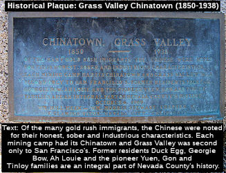 The Route 20/Route 49 SW-bound frontage road in
Grass Valley from the intersection with South Auburn Street to Bennett
Street (~NEV R12.856 to NEV R13.12) is officially named "Tinloy Street."
This segment was named in honor of the Tinloy family of Grass Valley. The
Tinloy family has Chinese roots and its presence in Grass Valley dates back to the 19th century. John Tinloy was born to Kan Tinloy. Kan Tinloy, emigrated to Nevada County from Canton province
in southern China during the Gold Rush. He eventually settled in Grass
Valley’s Chinatown, where he opened the Quong Chong Co. general
store store in the late 1880s. Kan Tinloy eventually returned to China,
where he died. His son, John Tinloy (1876-1944), who was born in China and
came to America after his father had sent for him, took over the Quong
Chong store, which he ran until the 1920s. The Qunog Chong store offered
Chinese traditional food and artifacts, and this store evolved into a
social place, bank, and an employment bureau. In 1912, John Tinloy was
“the most influential individual in local Chinatown,”
according to an article published by the Nevada County Historical Society
in 1972. He married (Alice) Chen Shee, and together they raised one
daughter and three sons, and the family opened and operated a fine women's
apparel store and a grocery store in Grass Valley. The Tinloy family was
active in the Methodist Church in Grass Valley. The Tinloy family,
stemming from the community activism of John Tinloy, has historically been
very civic minded and contributed community service and philanthropic
gifts to the community. Named by Senate Concurrent Resolution (SCR) 11,
Resolution Chapter 121, on 9/14/2005.
The Route 20/Route 49 SW-bound frontage road in
Grass Valley from the intersection with South Auburn Street to Bennett
Street (~NEV R12.856 to NEV R13.12) is officially named "Tinloy Street."
This segment was named in honor of the Tinloy family of Grass Valley. The
Tinloy family has Chinese roots and its presence in Grass Valley dates back to the 19th century. John Tinloy was born to Kan Tinloy. Kan Tinloy, emigrated to Nevada County from Canton province
in southern China during the Gold Rush. He eventually settled in Grass
Valley’s Chinatown, where he opened the Quong Chong Co. general
store store in the late 1880s. Kan Tinloy eventually returned to China,
where he died. His son, John Tinloy (1876-1944), who was born in China and
came to America after his father had sent for him, took over the Quong
Chong store, which he ran until the 1920s. The Qunog Chong store offered
Chinese traditional food and artifacts, and this store evolved into a
social place, bank, and an employment bureau. In 1912, John Tinloy was
“the most influential individual in local Chinatown,”
according to an article published by the Nevada County Historical Society
in 1972. He married (Alice) Chen Shee, and together they raised one
daughter and three sons, and the family opened and operated a fine women's
apparel store and a grocery store in Grass Valley. The Tinloy family was
active in the Methodist Church in Grass Valley. The Tinloy family,
stemming from the community activism of John Tinloy, has historically been
very civic minded and contributed community service and philanthropic
gifts to the community. Named by Senate Concurrent Resolution (SCR) 11,
Resolution Chapter 121, on 9/14/2005.
(Image credit: Historical Marker Database)
 Named Structures
 The Brighton Street Overcrossing over Route 20 (Bridge 17-0095 NEV R011.83) in the City of Grass Valley is named
the "Gold Star Memorial Bridge". It was named in memory of Lance
Corporal Adam Strain, Lance Corporal John "JT" Lucente, and Corporal Sean
A. Stokes. Lance Corporal Adam Strain, from the City of Smartville, who
had wanted to be a Marine since he was old enough to play with toy
soldiers, and knew at 15 years of age that he wanted to help his nation at
war. Lance Corporal Strain played defensive end on the Nevada Union High
School Miner's football team and graduated from that school in 2003. Lance
Corporal Strain, who was assigned to 1st Battalion, 5th Marine Regiment,
1st I Marine Division, 1st Marine Expeditionary Force, Camp Pendleton,
attached to 2nd Marine Division, 2nd II Marine Expeditionary Force
(Forward), was killed in action in Iraq on August 3, 2005, at 20 years of
age. Lance Corporal John "JT" Lucente, from the City of Lakeof the Pines,
joined the United States Marine Corps during his junior year at Bear River
High School, where he had written his senior project on the Marine Corps,
and following his graduation from that school in 2004, began active duty.
Lance Corporal Lucente had decided to join the Marine Corps out of a deep
desire to serve God and country. Lance Corporal Lucente proudly wore his
Marine uniform and felt proud that he completed the rigorous training
required to become a Marine. Lance Corporal Lucente was an honorable man,
who bore his commitment to the Marines with dignity and respect, and was
very proud to serve his country. Lance Corporal Lucente, who was assigned
to Battalion Landing Team 2nd Battalion, 1st Marine Regiment, 13th Marine
Expeditionary Unit, I Marine Expeditionary Force, Camp Pendleton, attached
to II Marine Division, 2nd Marine Expeditionary Force (Forward), was
killed in action in Iraq on November 16, 2005, at 19 years of age.
Corporal Sean A. Stokes, from the City of Lake of the Pines, graduated
from Bear River High School in 2001. Corporal Stokes was courageous,
dedicated, and passionate about serving as a Marine, cared deeply for his
fellow Marines, and extended his enlistment to volunteer for a third tour
of duty to serve with his platoon when it was redeployed to Iraq. Corporal
Stokes, who was assigned to 3rd Battalion, 1st Marine Regiment, I Marine
Division, 1st Marine Expeditionary Force, was killed in action in Iraq on
July 30, 2007, at 24 years of age. Named by Senate Concurrent Resolution
78, Resolution Chapter 88, on August 24, 2012.
The Brighton Street Overcrossing over Route 20 (Bridge 17-0095 NEV R011.83) in the City of Grass Valley is named
the "Gold Star Memorial Bridge". It was named in memory of Lance
Corporal Adam Strain, Lance Corporal John "JT" Lucente, and Corporal Sean
A. Stokes. Lance Corporal Adam Strain, from the City of Smartville, who
had wanted to be a Marine since he was old enough to play with toy
soldiers, and knew at 15 years of age that he wanted to help his nation at
war. Lance Corporal Strain played defensive end on the Nevada Union High
School Miner's football team and graduated from that school in 2003. Lance
Corporal Strain, who was assigned to 1st Battalion, 5th Marine Regiment,
1st I Marine Division, 1st Marine Expeditionary Force, Camp Pendleton,
attached to 2nd Marine Division, 2nd II Marine Expeditionary Force
(Forward), was killed in action in Iraq on August 3, 2005, at 20 years of
age. Lance Corporal John "JT" Lucente, from the City of Lakeof the Pines,
joined the United States Marine Corps during his junior year at Bear River
High School, where he had written his senior project on the Marine Corps,
and following his graduation from that school in 2004, began active duty.
Lance Corporal Lucente had decided to join the Marine Corps out of a deep
desire to serve God and country. Lance Corporal Lucente proudly wore his
Marine uniform and felt proud that he completed the rigorous training
required to become a Marine. Lance Corporal Lucente was an honorable man,
who bore his commitment to the Marines with dignity and respect, and was
very proud to serve his country. Lance Corporal Lucente, who was assigned
to Battalion Landing Team 2nd Battalion, 1st Marine Regiment, 13th Marine
Expeditionary Unit, I Marine Expeditionary Force, Camp Pendleton, attached
to II Marine Division, 2nd Marine Expeditionary Force (Forward), was
killed in action in Iraq on November 16, 2005, at 19 years of age.
Corporal Sean A. Stokes, from the City of Lake of the Pines, graduated
from Bear River High School in 2001. Corporal Stokes was courageous,
dedicated, and passionate about serving as a Marine, cared deeply for his
fellow Marines, and extended his enlistment to volunteer for a third tour
of duty to serve with his platoon when it was redeployed to Iraq. Corporal
Stokes, who was assigned to 3rd Battalion, 1st Marine Regiment, I Marine
Division, 1st Marine Expeditionary Force, was killed in action in Iraq on
July 30, 2007, at 24 years of age. Named by Senate Concurrent Resolution
78, Resolution Chapter 88, on August 24, 2012.
(Image sources: AARoads; LA Times (AJS); ArllingtonCemetary
(JAL); LA Times (SAS))
 Bridge 17-083, at the Mill Street Undercrossing in Grass Valley in Nevada county (NEV R012.16), is named the
"Ernest J. Stidham, 1st Lieutenant, Memorial Bridge". It was built
in 1969, and was named by Assembly Concurrent Resolution 43, Chapter 220,
in 1971. First Lieutenant Ernest James Stidham, casualty of the Vietnam
War. As a member of the Army Reserve, 1LT Stidham served our country until
December 22nd, 1968 in Tay Ninh, South Vietnam. He was 25 years old and
was not married. Ernest died from small arms fire. Ernest was born on
March 14th, 1943 in Carmichael, California.
Bridge 17-083, at the Mill Street Undercrossing in Grass Valley in Nevada county (NEV R012.16), is named the
"Ernest J. Stidham, 1st Lieutenant, Memorial Bridge". It was built
in 1969, and was named by Assembly Concurrent Resolution 43, Chapter 220,
in 1971. First Lieutenant Ernest James Stidham, casualty of the Vietnam
War. As a member of the Army Reserve, 1LT Stidham served our country until
December 22nd, 1968 in Tay Ninh, South Vietnam. He was 25 years old and
was not married. Ernest died from small arms fire. Ernest was born on
March 14th, 1943 in Carmichael, California.
(Image source: Waymarking; HonorStates.org)
 Bridge 17-049 at the Route 20/Route 49 separation and
Empire Street (NEV R012.24), is named the "Bruce Allen Jensen, Lt.
Col., USAF, Bridge". It was built in 1969, and was named by Assembly
Concurrent Resolution 43, Chapter 220, in 1971. Lieutenant Colonel Bruce
Allan Jensen was a casualty of the Vietnam War. As a member of the Air
Force, LTC Jensen served our country until August 27th, 1967 in Laos. He
was 38 years old and was married. Bruce died when his plane crashed into
the land.
Bridge 17-049 at the Route 20/Route 49 separation and
Empire Street (NEV R012.24), is named the "Bruce Allen Jensen, Lt.
Col., USAF, Bridge". It was built in 1969, and was named by Assembly
Concurrent Resolution 43, Chapter 220, in 1971. Lieutenant Colonel Bruce
Allan Jensen was a casualty of the Vietnam War. As a member of the Air
Force, LTC Jensen served our country until August 27th, 1967 in Laos. He
was 38 years old and was married. Bruce died when his plane crashed into
the land.
(Image source: Waymarking; Vietnam Veterans Memorial)
 Bridge 17-050, at the Route 20/Route 174
separation in Nevada county (NEV R012.85), is named the "David E.
Freestone and Harry Lee Theurkauf Memorial Bridge". It was built in
1970, and was named by Assembly Concurrent Resolution 43, Chapter 220, in
1971. Private First Class David Edward Freestone was a casualty of the
Vietnam War. As a member of the Army, PFC Freestone served our country
until August 27th, 1969 in Binh Duong, South Vietnam. He was 20 years old
and was not married. David died from small arms fire. Specialist Five
Harry Lee Theurkauf was also a casualty of the Vietnam War. As a member of
the Army, SP5 Theurkauf served our country until June 5th, 1968 in Binh
Duong, South Vietnam. He was 22 years old and was not married. Harry died
from artillery fire.
Bridge 17-050, at the Route 20/Route 174
separation in Nevada county (NEV R012.85), is named the "David E.
Freestone and Harry Lee Theurkauf Memorial Bridge". It was built in
1970, and was named by Assembly Concurrent Resolution 43, Chapter 220, in
1971. Private First Class David Edward Freestone was a casualty of the
Vietnam War. As a member of the Army, PFC Freestone served our country
until August 27th, 1969 in Binh Duong, South Vietnam. He was 20 years old
and was not married. David died from small arms fire. Specialist Five
Harry Lee Theurkauf was also a casualty of the Vietnam War. As a member of
the Army, SP5 Theurkauf served our country until June 5th, 1968 in Binh
Duong, South Vietnam. He was 22 years old and was not married. Harry died
from artillery fire.
(Image source: Waymarking; Virtual Wall Vietnam Veterans Memorial; HonorStates.org)
 Bridge 17-051, the Bank Street undercrossing in Nevada county (NEV R013.04), is named the "Kenneth W.
Scurr Memorial Bridge". It was built in 1969, and was named by
Assembly Concurrent Resolution 43, Chapter 220, in 1971. Kenneth Wesley
Scurr was a casualty of the Vietnam War. As a member of the Army Reserve,
1LT Scurr served our country until May 31st, 1969 in Pleiku, South
Vietnam. He was 20 years old and was not married. Kenneth died from small
arms fire. Kenneth was born on July 12th, 1948 in Grass Valley,
California.
Bridge 17-051, the Bank Street undercrossing in Nevada county (NEV R013.04), is named the "Kenneth W.
Scurr Memorial Bridge". It was built in 1969, and was named by
Assembly Concurrent Resolution 43, Chapter 220, in 1971. Kenneth Wesley
Scurr was a casualty of the Vietnam War. As a member of the Army Reserve,
1LT Scurr served our country until May 31st, 1969 in Pleiku, South
Vietnam. He was 20 years old and was not married. Kenneth died from small
arms fire. Kenneth was born on July 12th, 1948 in Grass Valley,
California.
(Image source: The Union; VietnamVeterans
Memorial Fund - Wall of Faces)
 Bridge 17-052, the Bennet Street undercrossing in Nevada county (NEV R013.11), is named the "John Robert Kunkel Bridge". It was
built in 1969, and was named by Assembly Concurrent Resolution 43, Chapter
220, in 1971. Lance Corporal John Robert Kunkel was a casualty of the
Vietnam War. As a member of the Marine Corps, LCPL Kunkel served our
country until January 3rd, 1969 in Quang Nam, South Vietnam. He was 21
years old and was not married. John died from small arms fire. John was
born on April 16th, 1947 in Santa Clara, California.
Bridge 17-052, the Bennet Street undercrossing in Nevada county (NEV R013.11), is named the "John Robert Kunkel Bridge". It was
built in 1969, and was named by Assembly Concurrent Resolution 43, Chapter
220, in 1971. Lance Corporal John Robert Kunkel was a casualty of the
Vietnam War. As a member of the Marine Corps, LCPL Kunkel served our
country until January 3rd, 1969 in Quang Nam, South Vietnam. He was 21
years old and was not married. John died from small arms fire. John was
born on April 16th, 1947 in Santa Clara, California.
(Image source: Waymarking; Vietnam Veterans Memorial Fund - Wall of Faces)
 Bridge 17-079, the Idaho-Maryland Road undercrossing in Nevada county (NEV R013.61), is named the "Douglas A. Rix Memorial Bridge".
It was built in 1969, and named by Assembly Concurrent Resolution 43,
Chapter 220, in 1971. Staff Sergeant Douglas Alfred Rix was a casualty of
the Vietnam War. As a member of the Army, SSG Rix served our country until
February 28th, 1967 in Tay Ninh, South Vietnam. He was 24 years old and
was married. Douglas died from multiple fragmentation wounds. Douglas was
born on October 29th, 1942 in Grass Valley, California.
Bridge 17-079, the Idaho-Maryland Road undercrossing in Nevada county (NEV R013.61), is named the "Douglas A. Rix Memorial Bridge".
It was built in 1969, and named by Assembly Concurrent Resolution 43,
Chapter 220, in 1971. Staff Sergeant Douglas Alfred Rix was a casualty of
the Vietnam War. As a member of the Army, SSG Rix served our country until
February 28th, 1967 in Tay Ninh, South Vietnam. He was 24 years old and
was married. Douglas died from multiple fragmentation wounds. Douglas was
born on October 29th, 1942 in Grass Valley, California.
(Image source: Waymarking; HonorStates.org)
 Bridge 17-081, the Dorsey Drive overcrossing in Nevada county (NEV R014.26), is named the "Thomas W. Cranford Memorial Bridge". It was
built in 1969, and was named by Assembly Concurrent Resolution 43, Chapter
220, in 1971. Airman First Class Thomas W. Cranford was a casualty of the
Vietnam War. As a member of the Air Force, PFC Cranford served our country
until May 9, 1968 in Ho Chi Minh (Saigon), Hồ Chí Minh
Municipality, Vietnam. He was 21 years old. Note: The original resolution mistakenly had the name as Crawford.
Bridge 17-081, the Dorsey Drive overcrossing in Nevada county (NEV R014.26), is named the "Thomas W. Cranford Memorial Bridge". It was
built in 1969, and was named by Assembly Concurrent Resolution 43, Chapter
220, in 1971. Airman First Class Thomas W. Cranford was a casualty of the
Vietnam War. As a member of the Air Force, PFC Cranford served our country
until May 9, 1968 in Ho Chi Minh (Saigon), Hồ Chí Minh
Municipality, Vietnam. He was 21 years old. Note: The original resolution mistakenly had the name as Crawford.
(Image source: Waymarking; Vietnam Veterans Memorial Foundation)
 Bridge 17-048, at the Brunswick Road overcrossing in Nevada county (NEV R014.80), is named the "Gary Ames
Miller Memorial Bridge". It was built in 1969, and was named by
Assembly Concurrent Resolution 43, Chapter 220 in 1971. Lance Corporal
Gary Ames Miller was a casualty of the Vietnam War. As a member of the
Marine Corps, LCPL Miller served our country until June 1st, 1966 in Quang
Tin, South Vietnam. He was 18 years old and was not married. Gary died
from small arms fire.
Bridge 17-048, at the Brunswick Road overcrossing in Nevada county (NEV R014.80), is named the "Gary Ames
Miller Memorial Bridge". It was built in 1969, and was named by
Assembly Concurrent Resolution 43, Chapter 220 in 1971. Lance Corporal
Gary Ames Miller was a casualty of the Vietnam War. As a member of the
Marine Corps, LCPL Miller served our country until June 1st, 1966 in Quang
Tin, South Vietnam. He was 18 years old and was not married. Gary died
from small arms fire.
(Image source: Wayfinding; Find a Grave)
 Bridge 17-077, the Banner Ridge Road overcrossing in Nevada county (NEV R015.41), is named the "James F.
Deeble Memorial Bridge". It was built in 1967, and was named by
Assembly Concurrent Resolution 43, Chapter 220, in 1971. First Lieutenant
James Frederick Deeble was a casualty of the Vietnam War. As a member of
the Army Reserve, 1LT Deeble served our country until April 18th, 1970 in
Bing Thuy, South Vietnam. He was 23 years old and was not married. James
died from multiple fragmentation wounds. James was born on July 8th, 1946
in Nevada City, California.
Bridge 17-077, the Banner Ridge Road overcrossing in Nevada county (NEV R015.41), is named the "James F.
Deeble Memorial Bridge". It was built in 1967, and was named by
Assembly Concurrent Resolution 43, Chapter 220, in 1971. First Lieutenant
James Frederick Deeble was a casualty of the Vietnam War. As a member of
the Army Reserve, 1LT Deeble served our country until April 18th, 1970 in
Bing Thuy, South Vietnam. He was 23 years old and was not married. James
died from multiple fragmentation wounds. James was born on July 8th, 1946
in Nevada City, California.
(Image source: Artillery OCS Alumni)
 Bridge 17-082, the Gold Flat Road undercrossing in Nevada county (NEV R015.92), is named the "John Stuart
Seeley Memorial Bridge". It was built in 1967, and was named by
Assembly Concurrent Resolution 43, Chapter 220, in 1971. Captain John
Stuart Seeley was a casualty of the Vietnam War. As a member of the Army
Reserve, CPT Seeley served our country until June 27th, 1966 in South
Vietnam. He was 34 years old and was married. John died when his
helicopter crashed into the land. John was born on April 10th, 1932 in
Stockton, California.
Bridge 17-082, the Gold Flat Road undercrossing in Nevada county (NEV R015.92), is named the "John Stuart
Seeley Memorial Bridge". It was built in 1967, and was named by
Assembly Concurrent Resolution 43, Chapter 220, in 1971. Captain John
Stuart Seeley was a casualty of the Vietnam War. As a member of the Army
Reserve, CPT Seeley served our country until June 27th, 1966 in South
Vietnam. He was 34 years old and was married. John died when his
helicopter crashed into the land. John was born on April 10th, 1932 in
Stockton, California.
(Image source: Wayfinding; HonorStates.org)
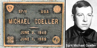 Bridge 17-053, the Sacramento Street overcrossing in Nevada county (NEV R016.74), is named the "Michael
Goeller Memorial Bridge". It was built in 1967, and was named by
Assembly Concurrent Resolution 43, Chapter 220, in 1971. Specialist Four
Michael Dennis Goeller was a casualty of the Vietnam War. As a member of
the Army, SP4 Goeller served our country until June 1st, 1969 in Binh
Duong, South Vietnam. He was 20 years old and was married. Michael died
when his helicopter crashed into the land. Michael was born on June 7th,
1948 in Nevada City, California.
Bridge 17-053, the Sacramento Street overcrossing in Nevada county (NEV R016.74), is named the "Michael
Goeller Memorial Bridge". It was built in 1967, and was named by
Assembly Concurrent Resolution 43, Chapter 220, in 1971. Specialist Four
Michael Dennis Goeller was a casualty of the Vietnam War. As a member of
the Army, SP4 Goeller served our country until June 1st, 1969 in Binh
Duong, South Vietnam. He was 20 years old and was married. Michael died
when his helicopter crashed into the land. Michael was born on June 7th,
1948 in Nevada City, California.
(Image source: Waymarking; VVMF Wall of Faces)
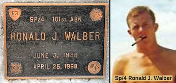 Bridge 17-055, the Broad Street overcrossing in Nevada county (NEV R016.99), is named the "Ronald J. Walber Bridge". It
was built in 1967, and was named by Assembly Concurrent Resolution 43,
Chapter 220, in 1971. Specialist Four Ronald James Walber was a casualty
of the Vietnam War. As a member of the Army, SP4 Walber served our country
until April 25th, 1968 in Binh Duong, South Vietnam. He was 19 years old
and was not married. Ronald died from multiple fragmentation wounds.
Ronald was born on June 3rd, 1948 in Nevada City, California.
Bridge 17-055, the Broad Street overcrossing in Nevada county (NEV R016.99), is named the "Ronald J. Walber Bridge". It
was built in 1967, and was named by Assembly Concurrent Resolution 43,
Chapter 220, in 1971. Specialist Four Ronald James Walber was a casualty
of the Vietnam War. As a member of the Army, SP4 Walber served our country
until April 25th, 1968 in Binh Duong, South Vietnam. He was 19 years old
and was not married. Ronald died from multiple fragmentation wounds.
Ronald was born on June 3rd, 1948 in Nevada City, California.
(Image source: Waymarking; VVMF Wall of Faces)
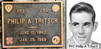 Bridge 17-056, the Washington Street overcrossing in Nevada county (NEV R017.18), is named the "Philip A.
Tritsch Memorial Bridge". It was built in 1967, and was named by
Assembly Concurrent Resolution 43, Chapter 220, in 1971. Private First
Class Philip Alon Tritsch was casualty of the Vietnam War. As a member of
the Army Selective Service, PFC Tritsch served our country until January
28th, 1969 in Kontum, South Vietnam. He was 25 years old and was not
married. Philip died from small arms fire. Philip was born on June 10th,
1943 in Nevada City, California.
Bridge 17-056, the Washington Street overcrossing in Nevada county (NEV R017.18), is named the "Philip A.
Tritsch Memorial Bridge". It was built in 1967, and was named by
Assembly Concurrent Resolution 43, Chapter 220, in 1971. Private First
Class Philip Alon Tritsch was casualty of the Vietnam War. As a member of
the Army Selective Service, PFC Tritsch served our country until January
28th, 1969 in Kontum, South Vietnam. He was 25 years old and was not
married. Philip died from small arms fire. Philip was born on June 10th,
1943 in Nevada City, California.
(Image source: Waymarking; VVMF Wall of Faces)
This route also has the following Safety Roadside Rest Areas:
 Historical Route
 Business Routes Scenic Route
[SHC 263.3] From Route 101 near Calpella to Route 16; and from Route 49 near Grass Valley to Route 80 near Emigrant Gap.
 Classified Landcaped Freeway
The following segments are designated as Classified Landscaped Freeway:
| County | Route | Starting PM | Ending PM |
| Nevada | 20 | R12.30 | R13.68 |
| Nevada | 20 | R16.19 | 17.30 |
 Freeway
[SHC 253.2] Portion (2); form Ukiah to Emigrant Gap. It was constructed to freeway standards between Route 49 in Grass Valley and Route 49 in Nevada City. Added to the Freeway and Expressway system in 1959, Chapter 1062.
 Exit Information
 Blue Star Memorial Highway
The portion of this route that is former US 99 was designated as a "Blue Star Memorial Highway" by Senate Concurrent Resolution 33, Ch. 82 in 1947.
 Statistics
Overall statistics for Route 20:
 Interregional Route
[SHC 164.11] Entire route.
 Other WWW Links
 Pre-1964 Legislative Route
The routing that was to become [LRN 20] was first defined in 1903 by Chapter 366 as part of the Trinity-Humboldt State Highway, "for the purposes of locating and surveying a proposed highway from a point on the Trinity River near the town of North Fork, thences W-ly down said river to connect with an existing road in Humboldt County." However, this was a survey-only act, and was repealed in 1935.
LRN 20 was more properly defined as a route in the state highway system in the 1909 First Bond Act, as running "From Redding to Weaverville". In 1915, it was extended by the Second Bond Act (Chapter 404) from [LRN 1] in Arcata to Douglas City ("...an extension connecting the interior and trunk coast lines in Northern California through Trinity and Humboldt counties by the most direct and practical route;"). In 1933, it was extended further, by the addition of a segment from "[LRN 28] near Redding to Lassen National Park". By 1935, it was codified into the highway code as:
Only the first section was primary highway.
In 1957, Chapter 1911 combined these segments into the simpler “[LRN 1] near Arcata to Lassen National Park via Weaverville and Redding”. In 1959, Chapter 1062 extended the definition to add two segments, making the definition:
In 1963, the "great renumbering" changed the terminus of Section 3 to Termo.
Signage along this route was as follows:
Between Redding and Lassen National Park, this route was signed as Route 44. Note that Route 44 between Viola and Old Station was LRN 83, not LRN 20. At one point, the Route 44 portion of this may have been signed as Route 440.
© 1996-2020 Daniel P. Faigin.
Maintained by: Daniel P. Faigin
<webmaster@cahighways.org>.
 Route 19
 Route 21