
 California Highways:
Click here for a key to the symbols used. An explanation of acronyms may be found at the bottom of the page.
 Routing
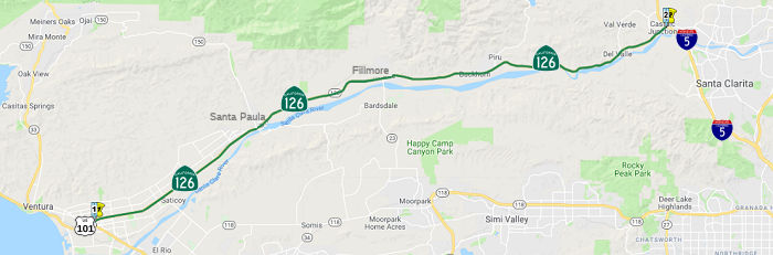 From Route 101 near Ventura to Route 5.
The relinquished former portion of Route 126 within the City of Santa Clarita is not a state highway and is not eligible for adoption under Section 81.
 Post 1964 Signage History
▸In 1963, Route 126 was defined as "(a) Route 101 near Ventura to Route 5. (b) Route 5 to Route 14 near Solemint."
On June 26, 1964, a 9.4-mile section of the Route 126 Freeway was adopted between the Golden State and Antelope Valley Freeways, estimated to cost $18 million.
Between US 101 and I-5, the route for a freeway was adopted in 1958.
After planning studies, the project was terminated because of financial
and technical problems. A 1973 estimate for the construction of a freeway
through the Santa Clara River Valley was $130,000,000. Extensive flood
protection would have been required through this narrow river valley.
Because the financing for this project could not be foreseen within a
20-year period, and the need for a freeway did not develop, the 1958
freeway adoption was rescinded in 1974.
(Source: kernals12
on AARoads, “Re: CA-126 eventually to be expanded to a full freeway from 5-101?”, April 2022)
▸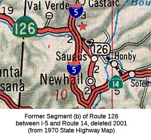 Prior to 2001, there was an additional segment that ran
from Route 5 to Route 14 near Solemint. Relinquishment of this segment was
authorized by AB 635, Chapter 575, 10/11/2001. The bill required that
Santa Clarita keep signs showing the way for travelers to get to the rest
of Route 126. The section (which is from PM R5.8 to T12.707) was up for
relinquishment in September 2002.
Prior to 2001, there was an additional segment that ran
from Route 5 to Route 14 near Solemint. Relinquishment of this segment was
authorized by AB 635, Chapter 575, 10/11/2001. The bill required that
Santa Clarita keep signs showing the way for travelers to get to the rest
of Route 126. The section (which is from PM R5.8 to T12.707) was up for
relinquishment in September 2002.
The non-freeway surface street routing of former segment (b) was along Magic Mountain Parkway (former Route 126), and then what is now called Railroad Ave and Newhall Ave (formerly, San Fernando Road). Evidence of this remains at the Elsmere Creek Bridge № 53C2320, which is at PM LA T12.51, just as Newhall Ave meets Route 14. There also appears to have been a routing along Soledad Canyon Road, dating back to when Soledad Canyon was LRN 23 prior to 1940.
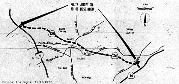 In 1963, a freeway routing was adopted between I-5 and
Route 14. The rough freeway routing started roughly where Newhall Ranch
Road is now, but instead of using Golden Valley (the Cross Valley
Connector route, see below), it would hewed closer to Newhall Ranch Road
to near Bouquet Canyon Road. Then, running closer to the Santa Clara
River, it would have crossed the river at Ruether Avenue. Running along
the south bank, it would have continued the vicinity of Whites Canyon
Road. At that point, it hewed closer to Via Princessa, running a bit N to
meet Route 14. Planned interchanges were at Rye Canyon, McBean, Bouquet
Canyon, Soledad Canyon, and Sierra Highway. In 1977, the CHC published a
notice to un-adopt the 9.4 mi segment of the Route 126 freeway between I-5
and Route 14.
In 1963, a freeway routing was adopted between I-5 and
Route 14. The rough freeway routing started roughly where Newhall Ranch
Road is now, but instead of using Golden Valley (the Cross Valley
Connector route, see below), it would hewed closer to Newhall Ranch Road
to near Bouquet Canyon Road. Then, running closer to the Santa Clara
River, it would have crossed the river at Ruether Avenue. Running along
the south bank, it would have continued the vicinity of Whites Canyon
Road. At that point, it hewed closer to Via Princessa, running a bit N to
meet Route 14. Planned interchanges were at Rye Canyon, McBean, Bouquet
Canyon, Soledad Canyon, and Sierra Highway. In 1977, the CHC published a
notice to un-adopt the 9.4 mi segment of the Route 126 freeway between I-5
and Route 14.
(Source: The Signal, 12/16/1977 via Joel Windmiller, 2/25/2023)
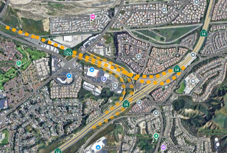 When they built the segment of the Antelope Valley Fwy
(Route 14) in this area in the early 1970s, they built the Sierra Highway
connectors as preparation for the Route 126 freeway. These are the Sierra
Highway offramps/onramps just before Via Princessa NB (there is no SB
connector). Reportedly, the Cedar Valley Way Overcrossing, which crosses
Route 14 just after the start of the Sierra Canyon NB off-ramp, was
also part of this construction. Constructed in 1972, a 2007 Google Street View map shows the bridge as fenced off. By December 2011, it was opened and striped for two-way traffic, the
intersection with Lost Hills allows exit from the the housing subdivision
only. The only way to enter that community is from Sierra Highway.
When they built the segment of the Antelope Valley Fwy
(Route 14) in this area in the early 1970s, they built the Sierra Highway
connectors as preparation for the Route 126 freeway. These are the Sierra
Highway offramps/onramps just before Via Princessa NB (there is no SB
connector). Reportedly, the Cedar Valley Way Overcrossing, which crosses
Route 14 just after the start of the Sierra Canyon NB off-ramp, was
also part of this construction. Constructed in 1972, a 2007 Google Street View map shows the bridge as fenced off. By December 2011, it was opened and striped for two-way traffic, the
intersection with Lost Hills allows exit from the the housing subdivision
only. The only way to enter that community is from Sierra Highway.
Michael Ballard has a good page on the Antelope Valley/Santa Paula Freeway interchange, including a map of the design of the interchange.
▸In 2003, AB 1717 (Ch. 525, 9/25/2003) updated the legislative definition to reflect the relinquishment.The relinquished former portion of Route 126 within the City of Santa Clarita is not a state highway and is not eligible for adoption as a state highway.
The segment from Route 5 to Route 14 was functionally replaced with the Cross Valley Connector (see below). According to the City of Santa Clarita, The Cross Valley Connector (CVC) is an 8½ mile roadway that connects to various streets, running from the I-5/Route 126 to Route 14. It is a $230+ Million project, and was completed in 2006. Pre 1964 Signage History
In 1934, Route 126 was signed along the route from Jct. US 101 near Ventura to Jct. US 99 at Castaic, via Santa Paula. It was LRN 79. The portion between Castaic Junction (US 99/I-5) and US 101 (LRN 2)) was defined in 1931. The portion from US 99/I-5 to Route 14 was originally part of the 1909 definition of LRN 4; it was routed off LRN 4 in 1939. It was adopted as a conventional highway by California Highway Commission on June 3, 1938. It was adopted as a freeway on April 19, 1956 from US 101 S of the City of Ventura NE-ly to the City of Santa Paula.
The original routing of Route 126 was:
(Source: Gribblenation Blog - California State Route 126; from CA 23 east to Santa Clarita)
The second segment of the route, defined after 1939, continued across the Ridge Route (now Magic Mountain Parkway) over to San Fernando Road (now Newhall/Railroad) over to Sierra Highway (US 6, Sign Route 7, now Route 14). Here's the summary of the route in this area, with LRN 79 being what became Route 126:
 LRN 4 originally continued
along San Fernando Road out of Sylmar. Originally, it continued as San
Fernando Road through the Newhall Tunnel along what is now Sierra
Highway, making a turn NNW before Placerita Canyon at San Fernando Road
(now Newhall Ave).
LRN 4 originally continued
along San Fernando Road out of Sylmar. Originally, it continued as San
Fernando Road through the Newhall Tunnel along what is now Sierra
Highway, making a turn NNW before Placerita Canyon at San Fernando Road
(now Newhall Ave). There appears to have been a spur of the route, according to a 1943 USGS map, that ran along LRN 154 (now Route 232) down Vineyard, to Route 1 near El Rio (LRN 2). It multiplexed LRN 2, leaving LRN 2 along Saviers Road down to Hueneme Road, and then across Hueneme Road to US 101A (LRN 2). This appears to correspond to a 1951 addition to the route -- but "The junction of [LRN 60] and Saviers Road in Ventura County, along the route of said road to [LRN 2] near El Rio." is Oxnard Blvd, and it doesn't correspond with the Seviers Road and Hueneme Road routing.
 Status
Much of this is freeway. As of 4/94, only the portion from Route 101 to Santa Paula, and from about .5 mi E of Route 5 to Route 5, was freeway. As of 2001, the entire route is, at minimum, 4 lanes.
In January 2002 and April 2002, the CTC voted on relinquishment of the portion of the route in the City of Santa Paula that was bypassed by the new freeway portion, PM 13.5.
In December 2019, the CTC authorized vacation of right of way in the city
of Santa Paula along Route 126 (Telegraph Road) between Padre Lane and
realigned Route 126 (07-Ven-126-PM R13.3/R13.6), consisting of superseded
highway right of way no longer needed for State highway purposes.
(Source: December 2019 CTC Agenda, Agenda Item
2.3d)
Route 126 "Blood Alley" Safety Improvements (~ VEN R14.782 to VEN 18.62)
In March 2016, it was noted that the segment of Route 126 E of Santa Paula is undivided,and has seen more than its share of
fatalities for decades. In 2007, after a rash of head-on collisions,
Caltrans proposed building a concrete median between Santa Paula and
Fillmore. The agency abandoned that idea when people who lived in and in
between the two cities objected, in part because a median would make it
difficult to turn on and off the highway from the roads that cross it. The
latest proposal is to install a series of four roundabouts: one located
halfway between Hobson Road and Fleischer Redmand Road (~ VEN R14.782);
one at the Toland Road intersection (~ VEN R15.989); one just west of
Spalding Drive (~ VEN 17.952); and one at Oak Village Road (VEN 18.62),
just west of Old Telegraph Road. It should be noted that roundabouts are
Caltrans' top choice at the moment, but the agency is also considering a
concrete barrier or raised island in the median. The goal of any of those
options would be to reduce the risk of cross-median head-on accidents, the
most likely to cause serious injury or death. The goal is drafting a
detailed analysis of the project over 2016 and securing final approval in
the summer of 2017.
(Source: Andy3175 @ AAroads, Feb 2016; VCStar
2/27/2016)
In October 2016, there was another article on the
safety problems on Route 126, again on the portion between Santa Paula and
Fillmore. On the portion that stretches from US 101 Freeway in Ventura to
the Fillmore city limits, approximately 21 miles, three fatal collisions
occurred in 2015, and two have occurred in 2016. A Road Safety Assessment,
studying Route 126 from Hallock Drive in Santa Paula to E Street in
Fillmore, a distance of about 7 miles, was conducted in 2014 by an
independent group, with the participation of Caltrans. It showed that out
of 320 total crashes that occurred from 2006 through 2012, there were nine
fatalities and 111 injury crashes. 36% were in some way attributed to
speeding, 28% were improper turns, and 6% were coded as “influence
alcohol” as the primary contributing factor. Three other crashes
involved a driver “Under Drug Influence” and 10 more crashes
involved drivers who were suffering from “fatigue.” Frequent
collisions also occur due to orchards surrounding Route 126 and it being a
two-lane highway. Trucks account for approximately 10 to 15% of the
traffic on this stretch of Route 126, according to the Road Safety
Assessment. Average daily traffic and truck counts are both expected to
increase with the proposed developments at Newhall Ranch (21,000 dwelling
units) and possibly at Limoneira East (up to 1,500 dwelling units). The
Road Safety Assessment and Comeaux also pointed out that traffic along
this corridor comes from three primary uses: agriculture, residential and
the through traffic traveling between I-5 and the Pacific Coast, crossing
through the cities of Santa Paula and Fillmore. Route 126 is also a
designated bike route. To address concerns regarding cross-median
collisions and fatalities, Caltrans initiated a median-barrier project,
reduced the posted speed limit, installed speed feedback signs and rumble
strips, and requested the Road Safety Assessment with the Federal Highway
Administration. Other measures considered include a concrete median
barrier or a raised median island with visual markers. However, a
median-barrier significantly reduces the places where drivers can make
left turns. Collisions are reduced, but if drivers can’t make left
turns, they will have to drive some distance to a place where they can
make a U-turn and come back to make a right turn. So as part of a possible
median barrier project, Caltrans is considering building four roundabouts
that would be spaced along Route 126 to give drivers convenient places to
make U-turns so they can go back to where they want to go. These would be
modern roundabouts, not older traffic circles. The current study that
Caltrans is conducting is expected to produce a draft environmental
document in approximately spring 2017; and a final environmental document
before the end of 2017.
(Source: VC Reporter, 10/5/2016)
OLeary Creek Bridge № 52-0196 Replacement (07-Ventura-126 T16.54)
In January 2024, Caltrans released the draft 2024
SHOPP, which contained the following project: 07-Ventura-126 T16.54. PPNO
07-5676; ProjID 0719000336; EA 36570. Route 126 Near Fillmore, at OLeary
Creek Bridge № 52-0196. Replace bridge. Proposed ($ ×
1000): PA&ED: $1,349; PS&E: $2,466; R/W $1,666; R/W Sup $426; Con
$11,027; Con Sup: $3,032; Total: $19,966. Begin Con: 2/26/2029.
(Source: 2024 Draft SHOPP v4.0, 1/31/2024)
In March 2024, the CTC approved the following
preconstruction environmental phase allocation: $1,349,000 (PA&ED).
07-Ventura-126 T16.54. PPNO 07-5676; ProjID 0719000336; EA 36570. Route 126 Near Fillmore, at OLeary Creek Bridge № 52-0196. Replace
bridge.
(Source: March 2024 CTC Agenda, Agenda Item 2.5b.(3) #29)
March 2026 review of the DRAFT 2026 SHOPP noted the
following updated instance of this project (updates in bold, if
possible): 07-Ventura-126 T16.54. PPNO 07-5676; ProjID
0719000336; EA 36570. Route 126 Near Fillmore, at OLeary Creek Bridge
№ 52-0196. Replace bridge. Proposed ($ × 1000):
PA&ED: $1,349; PS&E: $2,466; R/W Sup $426; Con Sup: $3,032; R/W $218;
Con $11,027; Total: $18,518. Begin Con: 5/1/2029.
(Source: Caltrans SHOPP Page: DRAFT 2026 SHOPP PROPOSED, State Highway Operation and Protection Program, Fiscal Years 2026-27 through 2029-30
(PDF), January 31, 2026; March 2026 CTC Agenda, Agenda Item 4.7)
Commerce Center Drive Interchange Improvements (~ LA R4.896)
In May 2010, the CTC approved for route adoption a project in Los Angeles County that will construct a grade-separated interchange at the existing signalized interchange of Route 126 and Commerce Drive near the city of Santa Clarita. As part of the project, Route 126 would be realigned to the south over a recently constructed embankment. The project is entirely funded from Metro Proposition C funds and private funds from Newhall Land and Farming Company. Total estimated project cost is $40,900,000 for capital and support. Construction is estimated to begin in Fiscal Year 2009-10. The project will involve construction activities that will result in potential impacts to water quality and noise. In addition, construction activities will be occurring in the habitat of the Peirson’s morning glory, a federal species of concern. As part of this, the CTC designated Route 126 in Los Angeles County from Castaic Creek to Route 5 west of City of Santa Clarita as a Controlled Access Highway. The proposed improvements will increase highway capacity, improve traffic operations, enhance driver safety and accommodate planned growth within the project area. Adoption of the proposed segment as a freeway is not practical because it would eliminate the Fire Department required emergency entrance/exit from an adjacent property owner. Attempts to maintain the required exits would severely reduce the commercial value of the property.
In July 2013, it was reported that a partnership of state and county agencies planned to break ground in mid-July or early August on a $50 million project to expand and reroute Route 126 near the Valencia Commerce Center. As designed, the project would entail construction of a bridge to lift Route 126 over Commerce Center Drive in Castaic, improving traffic flow on both routes. The projectwould also add new lanes on the highway, expanding it to three in each direction. The project also includes adding on- and off-ramps from Route 126 to Commerce Center Drive and Henry Mayo Drive, realigning and extending Henry Mayo Drive, adding new traffic signals at the intersection of Commerce Center and Henry Mayo drives and at the intersection of Route 126 and the access road to the Valencia Travel Village RV park. It also entails planting new landscaping to help stabilize the bank of the Santa Clara River near Route 126 and removing some invasive species to improve water flow in the river. The project is slated to be complete in late 2016. $9 million in funding for the project comes from a Metro grant, the remainder is in the form of bridge and major thoroughfare construction fees. Those fees are part of the costs that accompany residential and commercial development, such as the Newhall Ranch residential development project, which would add more than 20,000 homes along Route 126.
In October 2021, the CTC approved the following allocation for
preconstruction project phases: $999,000. 07-LA-126 R2.4. PPNO 07-5732;
ProjID 0720000138; EA 37070. Route 126 Near Del Valle, at the intersection
with Chiquito Canyon Road. Intersection improvements. Allocation: PS&E
$939,000 (Programmed) $982,000 (Allocated); R/W Sup $17,000.
(Source: October 2021 CTC Agenda, Agenda Item
2.5b.(2a) #13)
Note: This segment is no longer part of the state highway system.
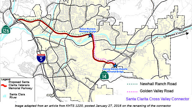 According to Don Hagstrom, in 1990, Caltrans offered to build a Route 126 Freeway from I-5 to Route 14. Santa Clarita
declined the offer. Instead, they planned to make up for this by
constructing a "Cross Valley Arterial." This would work as follows:
Starting at the interchange between I-5 and Route 126, Santa Clarita will
construct Newhall Ranch Road, a 6 and 8 lane arterial that will be a
de-facto extension of Route 126. The road itself will not be a freeway and
it will not carry the CA-126 designation (in fact, the CTC planned back
then to decommission this segment). On the other side (near Route 14),
Golden Valley Road would be extended westward to meet up with Newhall
Ranch Road. Somewhere in here the Santa Clara River would have to be
crossed. There also would be a grade-separated interchange built between
Golden Valley and Soledad Canyon Road.
According to Don Hagstrom, in 1990, Caltrans offered to build a Route 126 Freeway from I-5 to Route 14. Santa Clarita
declined the offer. Instead, they planned to make up for this by
constructing a "Cross Valley Arterial." This would work as follows:
Starting at the interchange between I-5 and Route 126, Santa Clarita will
construct Newhall Ranch Road, a 6 and 8 lane arterial that will be a
de-facto extension of Route 126. The road itself will not be a freeway and
it will not carry the CA-126 designation (in fact, the CTC planned back
then to decommission this segment). On the other side (near Route 14),
Golden Valley Road would be extended westward to meet up with Newhall
Ranch Road. Somewhere in here the Santa Clara River would have to be
crossed. There also would be a grade-separated interchange built between
Golden Valley and Soledad Canyon Road.
The SAFETEA-LU act, enacted in August 2005 as the reauthorization of TEA-21, provided the following expenditures on or near this route:
Note that the Cross Valley Connector is a surface artery across Santa Clarita, 25 miles further south, consisting of Newhall Ranch Road, about half of which is complete, and Golden Valley Road, which was recently finished. It won't be a freeway, and will probably never be used by anyone to get between I-5 and Route 14 (except maybe if an accident bogs down the freeways), as it will have at least a dozen traffic lights along its length.
Funding for the I-5 to Route 14 portion of the CVC was included in the SAFETEA-LU legislation passed in August 2005.
In January 2016, it was reported that the Santa Clarita City Council
passed a resolution to rename the Cross Valley Connector as the Santa
Clarita Veterans Parkway in honor of the more than 10,000
servicemen and women that reside in Santa Clarita” after a unanimous
vote by the city council. The Cross Valley Connector is an 8.5 mile
segment of roadway within the city of Santa Clarita that starts from the
intersection of Newhall Ranch Road and I-5, continues through the
intersection where Newhall Ranch Road turns into Golden Valley Road, and
ends at the intersection of Golden Valley Road and Route 14. Two bridges
along the Cross Valley Connector have received formal recognition,
including the Fallen Warriors Memorial Bridge and the Connie
Worden-Roberts Memorial Bridge. The Fallen Warriors Memorial Bridge
was dedicated by the Santa Clarita City Council on May 26, 2011. The
bridge connects Newhall Ranch Road and Golden Valley Road and was
dedicated in honor of the service men and women who lost their lives in
Iraq and Afghanistan, according to Tuesday’s agenda. Additionally,
an Assembly Concurrent Resolution was adopted on Sept. 15, 2015 to
designate the Golden Valley Road Bridge over the Route 14 Freeway in honor
of long-time Santa Clarita resident and community leader Connie
Worden-Roberts, becoming the Connie Worden-Roberts Memorial Bridge.
(Source: KHTS 1220, 1/27/2016)
In February 2019, it was reported that the Newhall Ranch Road Bridge
Widening project was completed. Newhall Ranch Road is considered one of
the major sections of the cross-valley connector, which provides motorists
a path from I-5 to Route 14 by way of surface streets. An estimated 35,000
vehicles pass through the bridge on a daily basis. Located in the area
between Avenue Tibbitts/Dickason Drive and McBean Parkway, the project was
designed to improve traffic circulation. The updated bridge now offers
four travel lanes in the east and west directions, landscaped medians, a
crossing path with protective concrete barriers for pedestrians and
cyclists and an enhanced trail connection underneath the bridge for people
to safely pass.
(Source: SCV Signal, 2/27/2019)
 Naming
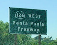 The portion from Route 101 to Route 5 is
designated as the "Santa Paula Freeway". The first segment opened
in 1963. It was named by Senate Bill 835, Chapter 223, in 1967.
The portion from Route 101 to Route 5 is
designated as the "Santa Paula Freeway". The first segment opened
in 1963. It was named by Senate Bill 835, Chapter 223, in 1967.
(Image source: OK Roads)
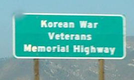 The portion of Route 126 between US 101 and the City of Santa Paula (~ VEN
0.000 to VEN R13.193) is officially designated the "Korean War Veterans
Memorial Highway". Named by Assembly Concurrent Resolution No. 135,
Chapter 89, on June 27, 2002.
The portion of Route 126 between US 101 and the City of Santa Paula (~ VEN
0.000 to VEN R13.193) is officially designated the "Korean War Veterans
Memorial Highway". Named by Assembly Concurrent Resolution No. 135,
Chapter 89, on June 27, 2002.
(Image source: Flikr)
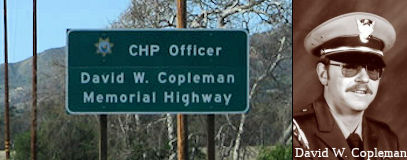 The portion of Route 126 from
Hallock Drive to the city limit of the City of Fillmore (~ VEN R12.773 to
VEN 19.934) in the County of Ventura is named the "California Highway
Patrol Officer David W. Copleman Memorial Highway". This segment was
named in memory of David W. Copleman, who was March 7, 1958, in Little
Rock, California. David W. Copleman entered the California Highway Patrol
Academy on the October 18, 1982; after graduation, he was assigned to the
Ventura Area Highway Patrol. Officer Copleman was killed in the line of
duty on the April, 6, 1985, when he was in pursuit on Route 126 and was
struck head-on by an uninvolved vehicle. Officer Copleman was a dedicated
officer who loved his job and enjoyed the people he worked with. He was a
wonderful father and husband and his greatest joy was spending time with
his family. In his spare time, David W. Copleman served the community of
Little Rock, California, as a volunteer firefighter. Named by Assembly
Concurrent Resolution (ACR) 46, Resolution Chapter 66, on 7/7/2005.
The portion of Route 126 from
Hallock Drive to the city limit of the City of Fillmore (~ VEN R12.773 to
VEN 19.934) in the County of Ventura is named the "California Highway
Patrol Officer David W. Copleman Memorial Highway". This segment was
named in memory of David W. Copleman, who was March 7, 1958, in Little
Rock, California. David W. Copleman entered the California Highway Patrol
Academy on the October 18, 1982; after graduation, he was assigned to the
Ventura Area Highway Patrol. Officer Copleman was killed in the line of
duty on the April, 6, 1985, when he was in pursuit on Route 126 and was
struck head-on by an uninvolved vehicle. Officer Copleman was a dedicated
officer who loved his job and enjoyed the people he worked with. He was a
wonderful father and husband and his greatest joy was spending time with
his family. In his spare time, David W. Copleman served the community of
Little Rock, California, as a volunteer firefighter. Named by Assembly
Concurrent Resolution (ACR) 46, Resolution Chapter 66, on 7/7/2005.
(Image source: AARoads, Calif. Assn. of Highway Patrolmen)
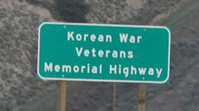 The portion between the City of Santa Paula and Route 5 (~ VEN R13.193 to LA
R5.558) is officially designated the "Korean War Veterans Memorial
Highway". Named by Senate Concurrent Resolution No. 41, Chapter 131,
in 1994.
The portion between the City of Santa Paula and Route 5 (~ VEN R13.193 to LA
R5.558) is officially designated the "Korean War Veterans Memorial
Highway". Named by Senate Concurrent Resolution No. 41, Chapter 131,
in 1994.
(Image source: Flikr)
 Exit Information
Note: An astute observer noted that the Commerce Center Exit in Santa
Clarita is numbered as Exit 13, when it should be Exit 39.
(Source: AARoads "Re: CA 126", 12/9/2019)
 Other WWW Links
 Classified Landcaped Freeway
The following segments are designated as Classified Landscaped Freeway:
| County | Route | Starting PM | Ending PM |
| Ventura | 126 | 0.00 | 0.21 |
| Ventura | 126 | R10.20 | R12.71 |
 Freeway
[SHC 253.1] Entire route. Added to the Freeway and Expressway system in 1959.
 Scenic Route
[SCH 263.6] From Route 150 near Santa Paula to Route 5 near Castaic.
Although this segment is eligible for Scenic Highway status, it has not yet met the criteria to be officially designated as Scenic Highway.
 Interregional Route
[SHC 164.16] Between the east urban limits of Oxnard-Ventura-Thousand Oaks and Route 5.
 Statistics
Overall statistics for Route 126:
 Pre-1964 Legislative Route
In 1933, Chapter 767 added the routes from "Fresno-Tracy West Side Highway near Kerman to [LRN 4] near Madera" and from "[LRN 4] near Madera to Fresno-Yosemite Road" to the highway system. In 1935, LRN 126 was added to the highway code with the definition:
This definition remained unchanged until the 1963 renumbering. It was signed as Route 145, and ran from Route 180 to Route 41, with a discontinuity on Route 99 near Madera.
Note: As defined in 1933, it appears that LRN 126 used Madera County Road
208, now a private road, from about 1 mi W of current Route 41 to Route 41. In 1939, Sign Route 41 was realigned and routed past Bates Station via
what is now Madera County Roads 209, 406 and 207. The new alignment of
Sign Route 41 bypassing Bates Station led LRN 126 being temporarily
extended west of Fresno-Yosemite Road at Millers Corner (later Twenty-Two
Mile House). LRN 126 itself was realigned to a new junction with
Route 41 and the new Friant Dam approach road (now Madera County Roads 145
and 206) in 1940. LRN 126 was signed as Sign Route 145 in
1948. Bellview Road would be designated as "Road 208" when Madera
County dropped naming conventions during the mid-twentieth century.
Wide Awake Ranch would eventually purchase Road 208 between Route 145-Road
209 and prohibit public access.
(Source: Gribblenation Blog, "Former Legislative Route Number 126 along Madera County Road 208", Feb 2025)
© 1996-2024 Daniel P. Faigin.
Maintained by: Daniel P. Faigin
<webmaster@cahighways.org>.
 Route 125
 Route 127