
 California Highways:
Click here for a key to the symbols used. An explanation of acronyms may be found at the bottom of the page.
 Routing
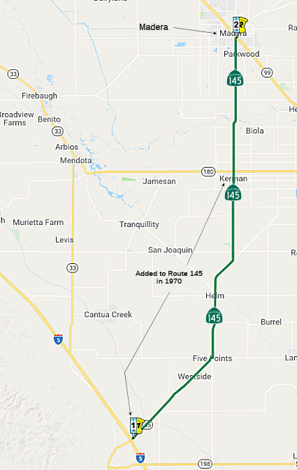 From Route 5 near Oilfields to Route 99 near Madera, passing near Five Points
and Kerman.
From Route 5 near Oilfields to Route 99 near Madera, passing near Five Points
and Kerman.
 Post 1964 Signage History
▸In 1963, this segment was defined as "(a) Route 180 near Kerman to Route 99 near Madera."
▸In 1970, Chapter 1473 extended the route from I-5 to Route 180,
making the definition: "(a) Route 5 near Oilfields Route 180 near Kerman to Route 99 near Madera, passing near Five
Points and Kerman". It is unclear when the county-maintained
roadways Route 145 used south of Kerman were adopted into the state
highway system and upgraded to state standards. Max R. has a travelog of
Route 145 here.
▸In 1996, the state added to the legislative definition the ability to relinquish to the City of Madera the portion of Route 145 located between Gateway Drive and Lake Street within the city, provided suitable terms are negotiated. The agreement must required the maintenance of signs directing motorists to the continuation of State Highway Route 145, and no reduction of the number of lanes within the relinquished section. (AB 2246, Chapter 540, 9/16/96)
A discussion of the Highways to Boulevards program during the March 2022
CTC meeting identified the following segment(s) as potential Highways to
Boulevards conversion projects: Route 145 in the city of Madera.
(Source: March 2022 CTC Agenda, Agenda Item 4.3)
 Pre 1964 Signage History
This entire routing was LRN 126, defined in 1933, except for the portion of segment 1 added in 1970. The original definition of LRN 126 was (1) LRN 41 (Sign Route 180) in Kerman to LRN 4 (US 99) in Madera, (2) LRN 4 (US 99) in Madera to LRN 125 (Sign Route 41). LRN 126 was not signed as part of the original 1934 signage of state routes, but appears to have been signed as Sign Route 145 sometime between 1948 and 1949, based on its first appearance on the state highway map in 1949.
The Skaggs Crossing Bridge (~ FRE 22.341 to FRE 22.933) was a former
component of Route 145 at the San Joaquin River. The Skaggs Crossing
Bridge was completed during 1907 as a connection between the communities
of Kerman and Madera. The Skaggs Crossing Bridge was added to the
State Highway System during 1933 as part of LRN 126 and would become part
of Sign Route 145 during 1948. The Skaggs Crossing Bridge was
removed during 2005 to make way for a new structure over the San Joaquin
River. The original bridge was a concrete bridge was constructed during
1907 as Skaggs Crossing, using a design similar to the design of the 1906
Pollasky Bridge (now in ruins downstream from Friant Dam). That bridge was
funded for replacement in FY65 with a new bridge at Skaggs Crossing.
(Source: Gribblenation Blog (Tom Fearer), "Former California State Route 145 on the Skaggs Crossing Bridge", 6/5/2023)
 In 1963 and 1964, the state adopted a freeway routing for
14 mi of Route 145 in Fresno and Madera counties. The Fresno segment was
5.7 mi from Route 180 in Kerman to 0.3 mi S of the Madera County Line. The
Madera County segment was 8.3 mi, from 0.2 mi N of Avenue 5½ to De
Santi Avenue in the city of Madera. During 1974 Fresno County purchased
the land parcels next to the Skaggs Crossing Bridge along the south bank
of the San Joaquin River, and formally created Skaggs Bridge Park.
The creation of Skaggs Bridge Park seems to have dealt a fatal blow to the
planned Route 145 freeway and replacement to the Skaggs Crossing Bridge.
In 1975, the CHC published a notice of intent to unadopt these freeway
segments, due to lack of funds and no foreseeable plans to build the
freeway.
In 1963 and 1964, the state adopted a freeway routing for
14 mi of Route 145 in Fresno and Madera counties. The Fresno segment was
5.7 mi from Route 180 in Kerman to 0.3 mi S of the Madera County Line. The
Madera County segment was 8.3 mi, from 0.2 mi N of Avenue 5½ to De
Santi Avenue in the city of Madera. During 1974 Fresno County purchased
the land parcels next to the Skaggs Crossing Bridge along the south bank
of the San Joaquin River, and formally created Skaggs Bridge Park.
The creation of Skaggs Bridge Park seems to have dealt a fatal blow to the
planned Route 145 freeway and replacement to the Skaggs Crossing Bridge.
In 1975, the CHC published a notice of intent to unadopt these freeway
segments, due to lack of funds and no foreseeable plans to build the
freeway.
(Source: Fresno Bee, 8/13/1975 via Joel Windmiller, 2/25/2023;
Gribblenation Blog (Tom Fearer), "Former California State Route 145 on the Skaggs Crossing Bridge", 6/5/2023)
A notice of determination via the provisions of the California
Environmental Quality Act during February 2001 approved the replacement of
the Skaggs Crossing Bridge with a modern highway span. The new San
Joaquin River Bridge and alignment of the Route 145 were completed east of
the Skaggs Crossing Bridge during 2005. Upon the 2005 San Joaquin
River Bridge opening, the Skaggs Crossing Bridge was removed. The
original alignment of Route 145 was repurposed as a disconnected part of
Madera Avenue, a Skaggs Bridge Park road and River Gorge Lane.
(Source: Gribblenation Blog (Tom Fearer), "Former California State Route 145 on the Skaggs Crossing Bridge", 6/5/2023)
 Status
Southern Segment Rumble Strips (06-Fresno-145 PM 0.0/33.6)
In August 2019, it was reported that funds from SB1
will contribute $470,000 to Route 145 improvements including centerline
and shoulder rumble strips from I-5 (FRE 0.000) to Church Avenue (~ FRE
33.622) near the city of Kerman. The improvements will total $5.8 million.
(Source: Sun Gazette, 8/21/2019)
The 2020 SHOPP, approved in May 2020, included the
following Collision Reduction item of interest (carried over from the 2018
SHOPP): 06-Fresno-145 PM 0.0/33.6 PPNO 6975 Proj ID 0619000020 EA 0Y420.
Route 145 Near Kerman, from Route 5 to Church Avenue. Construct centerline
and shoulder rumble strips.. Programmed in FY21-22, with construction
scheduled to start in March 2022. Total project cost is $5,780K, with
$3,420K being capital (const and right of way) and $2,360K being support
(engineering, environmental, etc.),
(Source: 2020 Approved SHOPP a/o May 2020)
In October 2020, the CTC approved the following SHOPP
Support Phase allocation: $940,000 for PS&E and $20,000 for R/W Sup
for 06-Fre-145 PM 0.0/33.6. PPNO 06-6975 ProjID 0619000020 EA 0Y420. Route 145 Near Kerman, from Route 5 to Church Avenue. Construct centerline and
shoulder rumble strips.
(Source: October 2020 CTC Agenda, Agenda Item
2.5b.(2a) #23)
In December 2020, the CTC amended the 2020 SHOPP to
add/revise the following project as indicated: 06-Fre-145 PM 0.0/33.6 PPNO
06-6975 ProjID 0619000020 EA 0Y420. Route 145 Near Kerman, from Route 5 to
Church Avenue. Construct centerline and shoulder rumble strips. Changes:
R/W Cap $20K $74K; Total $5,780K $5,834K.
Explanation: Increase in R/W capital is due to additional work for
positive location of underground utilities.
(Source: December 2020 CTC Agenda, Agenda Item
2.1a.(1d) #9)
In December 2021, the CTC was informed of the following
SHOPP Safety Sub-Allocations: $2,747,000. 06-Fre-145 0.0/33.6. PPNO
06-6975; ProjID 0619000020; EA 0Y420. Route 145 Near Kerman, from Route 5
to Church Avenue. Outcome/Output: Improve safety by constructing
centerline and shoulder rumble strips. This project will reduce the
number and severity of collisions.
(Source: December 2021 CTC Agenda, Agenda Item
2.5f.(3) #2)
Jensen Ave Roundabout (~ FRE 33.122)
In October 2011, it was reported that Caltrans has selected the intersection of Route 145 and Jensen Avenue near Kerman (~ FRE 33.122) for the first roundabout in the San Joaquin Valley. This intersection was chosen because it has had a high rate of accidents. Caltrans is also considering three sites in Tulare County and one each in Fresno, Kings and Kern counties for roundabouts (specifically, Route 168/Auberry Road in Prather, Route 216/Route 245 in Woodlake, Route 43/Route 137 in Corcoran, Route 190/Road 152 east of Tipton, Route 190/Road 284 east of Porterville, and Route 155/Browning Road in Delano). The Route 145 roundabout is anticipated to cost $1.1 million, and is scheduled to begin in mid-2013 and expected to take about a year to complete. The major concern was from growers and producers, who were worried that larger trucks hauling produce could not negotiate the circular intersections. A 2007 study of 55 roundabouts in the U.S. found a 35% reduction in accidents and a 90% reduction in fatal accidents when intersections with stop signs or signals were converted to roundabouts. It costs about the same to build a roundabout as to put up traffic signals, and they need significantly less maintenance than traffic signal intersections -- about 60% to 90% less, depending on how much landscaping work is required.
In January 2012, the CTC approved for future consideration of funding a project in Fresno County that will construct a single-lane roundabout at the intersection of Route 145 and Jensen Avenue in the city of Kerman to reduce traffic collisions. The project is programmed in the 2010 SHOPP. The total estimated project cost is $2,903,000 for capital and support. Construction is estimated to begin in Fiscal Year 2013-14. The scope, as described for the preferred alternative, is consistent with the project scope programmed by the Commission in the 2010 SHOPP.
The SAFETEA-LU act, enacted in August 2005 as the reauthorization of TEA-21, provided the following expenditures on or near this route:
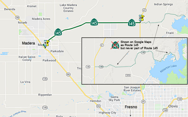 From Route 99 near Madera to Route 41.
Post 1964 Signage HistoryThis segment is unchanged from its 1963 definition.
Google Maps appears to show Route 145 continuing E from Route 41, along a lateral (Millerton Road) to Road 206, and then along O'Neill Road to Road 211, and then along another lateral (Millerton Road) to end near Duma Cove of Millerton Late. There is no record of this segment being part of Route 145.
Pre 1964 Signage HistoryThis entire routing was LRN 126, defined in 1933, except for the portion of segment 1 added in 1970. Signed Route 145 was not part of the original 1934 signage of state routes, but was signed by 1953.
Status
Downtown Madera Improvements (~ MAD 8.062 to MAD 10.155)
In March 2022, it was reported that after multiple
meetings with city officials and stakeholders, the state has produced
“State Route 145 Pavement Project and Complete Streets Plan”.
The plan consists of a “South Segment” along 3,020 feet of
South Madera Avenue, from Avenue 13 to the East Madera Underpass Bridge (~
MAD 8.062; a “Downtown Segment,” including major modifications
from E Street to Lake Street; and a “North Segment” from Lake
Street to an area a bit short of the High-Speed Rail (HSR) underpass.
Construction cost for the entire project is estimated at $13.4 million,
which includes $4 million for “complete streets enhancements.”
The scope of the plan includes removal and replacement of pavement;
installation and upgrading of curb ramps; installation of bicycle
facilities, bike parking, and bulb-outs; installation of transit stops;
and upgrading of traffic signals. With the exception of a more elaborate
plan for downtown Madera, the project seems to consist mainly of improving
sidewalks for walking and the creation of bike paths for bicycling from
Avenue 13 along South Madera Avenue, continuing along Gateway Drive, and
concluding along East Yosemite Avenue (Route 145) to the vicinity of the
HSR underpass. The “Downtown Segment” of the project outlines
the plans for renovation beginning at the east corners of Yosemite Avenue
and E Street and includes Route 145 to the east corners of Lake Street.
The current four traffic lanes will be reduced to two lanes. Throughout
the six-block stretch, existing curbside parking will be retained, with a
significant modification on the south side of Yosemite Avenue between D
Street and C Street. Along that one-block, slant-in parking spaces will be
marked; slant-in’s are opposite the flow of traffic, meaning that
drivers wishing to park their cars in that area will have to stop and back
into the parking spot. Also along this six-block stretch, traffic lanes
will be narrowed to 11 feet to allow for the addition of Class 2 bicycle
lanes. The plan also provides for the installation of 18 bulb-outs along
the six-block strip. According to Caltrans Design Standards, bulb-outs are
“curb extensions (that) may be installed as part of a traffic
calming project….” Bulb-outs will be placed on all four
corners of A Street, B Street, C Street, and D Street. The east corners of
E Street will be the locations for the 17th and 18th bulb-outs. The
“Lake Street Option” shows that traffic signals will be
retained and there will be two through lanes in each direction. However,
these lanes will also be narrowed to 11 feet in order to add the
5-foot-wide bicycle lanes. The plan also includes the installation of
traffic circles at the intersections of C Street and D Street with
Yosemite Avenue.
(Source: Madera Tribune, 3/2022)
 Freeway
[SHC 253.1] Entire route. Added to the Freeway and Expressway system in 1959.
 Other WWW Links
 Statistics
Overall statistics for Route 145:
 Pre-1964 Legislative Route
In 1933, Chapter 767 added the route from "[LRN 31] near Cajon Pass to [LRN 23] near Little Lake" to the highway system. In 1935, this route was added to the highway code as LRN 145 with that definition. The route remained unchanged until the 1963 renumbering. It is US 395 between US 91 (present-day I-15) and the US 395/US 6 (present-day US 395/Route 14) junction. This was defined in 1933.
© 1996-2020 Daniel P. Faigin.
Maintained by: Daniel P. Faigin
<webmaster@cahighways.org>.
 Route 144
 Route 146