
 California Highways:
Click here for a key to the symbols used. An explanation of acronyms may be found at the bottom of the page.
 Routing
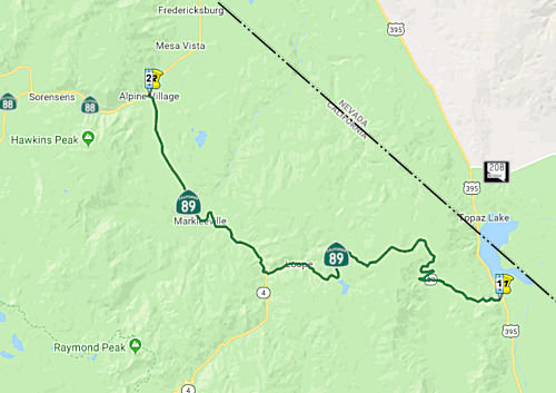 Route 395 near Coleville to Route 88 via the vicinity of Markleeville.
 Post 1964 Signage History
In 1963, this segment was defined as "(a) Route 395 near Coleville to Route 50 near Meyers via the vicinity of Markleeville."
In 1986, Chapter 928 split (a) into two parts: "(a) Route 395 near Coleville to Route 88 via the vicinity of Markleeville. (b) Route 88 near Picketts Junction to Route 50 near Meyers." The portion between the two segments was transferred to Route 88.
 Pre 1964 Signage History
This segment was initially created in 1926, but was not not signed as part of Route 89. In fact, the 1926 funded extension from Mono County to near Markeeville does not show as constructed on the state highway map until 1953, and doesn't show as signed as Route 89 until 1957. So, until 1953 (and possibly until 1957), the segment between Markleeville and Woodfords was signed as Route 4, and from 1953 (or 1957) on, it was cosigned as Route 4/Route 89. The Route 4 cosigning was dropped in 1964. Between Markleeville and Woodfords, the segment was constructed, but doesn't appear to have been signed as Route 89. Note that LRN 23 N of US 395 did cover all of what became Route 89, running from Jct. US 395 (one time Route 7) near Coleville to Jct. US 50 near Myers. The portion between US 395 and Markleeville was defined in 1926; the remainder was defined in 1911. In 1963, any co-signage with Route 4 was dropped.
 Naming
 The segment from the Alpine/Mono County line (ALP 0.0) to the junction of Route 89 and Route 4
(~ALP 9.969) is named the "Robert M. Jackson Memorial Highway".
This segment was named in memory of Robert M. Jackson, who was born in
Sacramento, California on September 21, 1912. His family moved to
Markleeville in Alpine County when he was two weeks old and remained there
until 1924 when they moved to Los Angeles County. Robert M. Jackson
returned every summer to Alpine county to work at the historic Alpine
Hotel. In 1942 Robert M. Jackson enlisted in the United States Army Air
Corps. He was stationed in Texas, Brazil, and finally in the Ascension
Islands. After being discharged in 1945, he returned to Markleeville where
he built the home he lived in for the rest of his life. In October 1946,
Robert M. Jackson began work with the Alpine County Public Works
Department, where he spent more than 30 years surveying, engineering,
constructing, and realigning many of the county and state highway routes
of today. Robert M. Jackson's most significant accomplishment was the
completion of Route 89 over Monitor Pass in the early 1950's. This 18-mile
span traverses both Alpine and Mono counties, and is a mountainous road
reaching elevations in excess of 8500 feet. The original road grade was
crooked and steep, as much as 17% in some places. The majority of the
survey work done by Robert M. Jackson was on horseback. Alpine County and
the Department of Transportation cooperated for 7 years to complete the
project, which was dedicated on September 12, 1954. Robert M. Jackson
retired from Alpine County in 1973, after 27 years of service. He remained
in Alpine County until his death on May 12, 2004. Named by Senate
Concurrent Resolution (SCR) 57, Resolution Chapter 27, on 4/21/2006.
The segment from the Alpine/Mono County line (ALP 0.0) to the junction of Route 89 and Route 4
(~ALP 9.969) is named the "Robert M. Jackson Memorial Highway".
This segment was named in memory of Robert M. Jackson, who was born in
Sacramento, California on September 21, 1912. His family moved to
Markleeville in Alpine County when he was two weeks old and remained there
until 1924 when they moved to Los Angeles County. Robert M. Jackson
returned every summer to Alpine county to work at the historic Alpine
Hotel. In 1942 Robert M. Jackson enlisted in the United States Army Air
Corps. He was stationed in Texas, Brazil, and finally in the Ascension
Islands. After being discharged in 1945, he returned to Markleeville where
he built the home he lived in for the rest of his life. In October 1946,
Robert M. Jackson began work with the Alpine County Public Works
Department, where he spent more than 30 years surveying, engineering,
constructing, and realigning many of the county and state highway routes
of today. Robert M. Jackson's most significant accomplishment was the
completion of Route 89 over Monitor Pass in the early 1950's. This 18-mile
span traverses both Alpine and Mono counties, and is a mountainous road
reaching elevations in excess of 8500 feet. The original road grade was
crooked and steep, as much as 17% in some places. The majority of the
survey work done by Robert M. Jackson was on horseback. Alpine County and
the Department of Transportation cooperated for 7 years to complete the
project, which was dedicated on September 12, 1954. Robert M. Jackson
retired from Alpine County in 1973, after 27 years of service. He remained
in Alpine County until his death on May 12, 2004. Named by Senate
Concurrent Resolution (SCR) 57, Resolution Chapter 27, on 4/21/2006.
(Image source: XBimmers: Robert M Jackson Highway by lennycarl08, on Flickr)
The segment from Route 4 (~ALP 9.969) to Rout 88 (~ ALP 21.248) is named the "Alpine State Highway". It was named by Resolution Chapter 468 in 1911. This segment also had the historic name of the "Big Trees Highway".
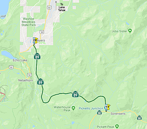 Route 88 near Picketts Junction to Route 50 near Meyers.
Post 1964 Signage HistoryIn 1963, the first segment of Route 89 was defined as "(a) Route 395 near Coleville to Route 50 near Meyers via the vicinity of Markleeville."
In 1986, Chapter 928 split (a) into two parts: "(a) Route 395 near Coleville to Route 88 via the vicinity of Markleeville. (b) Route 88 near Picketts Junction to Route 50 near Meyers." The portion between the two segments was transferred to Route 88.
Pre 1964 Signage HistoryIn 1934, Route 89 was signed along the route from Jct. Route 7 (US 395) near Coleville to Jct. US 99 (I-5) near Mt. Shasta, via Truckee, Quincy, and Chester. This segment was part of LRN 23, and was defined in 1911.
Near Luther Pass (ED 0.027, N of jct. with Route 88), the route (as LRN 23) first appears on a state highway map south of Lake Tahoe on the 1918
State Highway Map over Luther Pass as a special appropriations road. The
original alignment of LRN 23 and (Sign) Route 89 through Luther Pass was
on Upper Truckee Road. The original alignment through Luther Pass used
part of the modern Route 89 alignment but was on the west bank of the
Upper Truckee River as opposed to the east bank. This alignment is shown
on the 1935 California Division of Highways Maps of Alpine and El Dorado
Counties. By 1960, Route 89 was shifted east of the Upper Truckee River. Tom Fearer's blog post (from which this paragraph is condensed) has some good
maps showing these routings, and linking to the historical state highway
maps.
(Source: Gribblenation Blog: California State Route 89 through Luther Pass, 10/13/18)
50toLutherPass-adoption.jpg"
ALT="Rte 89: U.S. 50 to Luther Pass Adoption" TITLE="Rte 89: U.S. 50 to Luther Pass Adoption"
class="hwymap">In 1955, the California Highway Commission adopted a
revised routing for 8.5 mi of the Luther Pass Highway (Route 89) between
US 50 and the Alpine County Line. This section is on the Federal Forest
Highway System. Southerly from US 50, the route generally parallels the
existing highway but runs on the E side of the Upper Truckee River whereas
the northerly portion of the present highway is to the W of the stream.
About midway between US 50 and the county line, the adopted route takes a
wide southerly loop to avoid a particularly winding section of the
existing highway to the Alpine county line. The present highway is narrow
and winding and includes many steep pitches. The relocation eliminates the
sharp curves and provides easier grades. The original article indicated
that plans were to construct a modern 2-lane highway for 7.1 miles from US 50 to Grass Lake.
(Source: Auburn Journal, 5/30/1957 via Joel Windmiller, 1/27/2023)
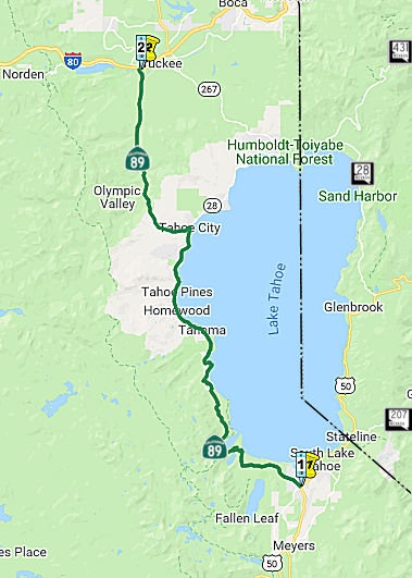 Route 50 near May's Junction to Route 80 via Tallac, Emerald Bay, McKinney's,
Tahoe City, and the Truckee River.
Route 50 near May's Junction to Route 80 via Tallac, Emerald Bay, McKinney's,
Tahoe City, and the Truckee River.
Post 1964 Signage HistoryThis segment is the original (b) from 1963.
See the "FREEWAY" section below for information on proposed freeway routings for this section.
Pre 1964 Signage HistoryIn 1934, Route 89 was signed along the route from Jct. Route 7 (US 395) near Coleville to Jct. US 99 (I-5) near Mt. Shasta, via Truckee, Quincy, and Chester. This segment was part of LRN 38, defined in 1911. Originally, Route 80 (I-80) was US 40.
In June 2017, it was reported that a late 1955 massive rock and earth
slide that engulfed Route 89 and tumbled all the way down to Emerald Bay,
forcing an 11-month road closure, prompted Tahoe business leaders to push
for highway improvements to to expand the Tahoe year-round economy. Some
talked of a San Francisco-sized population in the basin. “It became
evident,” a state Division of Highways analyst wrote, “that a
better route would have to be found to get past Emerald Bay (~ ED 14.802
to ED 18.625). The present road is narrow and crooked and impossible to
keep open during the winter.” Their notion: An Emerald Bay Bridge.
The state Division of Highways, the precursor to today’s Caltrans,
hired geologists, studied alignments, drew up engineering plans, and built
a scale model of an arched bridge, low to the water, to show at community
meetings. Officials even commissioned a serene watercolor artwork of the
bay fronted by a bridge that looked almost dainty on the landscape. The
debate was instantaneous, with strong arguments on both sides. Proponents
pointed to the Golden Gate Bridge, which was called beautiful and tourists
flocked to it. The Sacramento Bee and others were aghast. In a 1956
editorial, The Bee called the bridge “a tragic mistake bordering on
a crime.” State parks officials said the bridge express road would
mar not only Emerald Bay State Park but also would slice through nearby
D.L. Bliss State Park. The bridge was not the only major road change
officials considered at the time. The state also proposed a wider and
straighter mountain road above the bay that would run through a long
mountain tunnel. The debate – and the planning – continued
into the mid-1960s. But the idea was beginning to lose its footing. Bridge
opponents got an assist from an unlikely source, new Gov. Ronald Reagan.
Reagan appointed William Penn Mott Jr. as state parks chief. Mott came out
against the bridge. Two events were pivotal in its demise. In 1968, a
regional planning group formed by California and later joined by Nevada,
now called the Tahoe Regional Planning Agency, put together its first
Tahoe growth plan that year and declined to include the state’s
Emerald Bay Bridge project in it. Soon after that, a state committee
assembled by Reagan with Mott as a key member shelved the plan. The
following year, Emerald Bay was designated a National Natural Landmark.
(Source: Sacramento Bee, 5/28/2017)
The Union Pacific Overpass, Bridge № 19-0033 (03-ED-089 08.48), in
Truckee is called the “Mousehole”. It was built in 1928, and
is shaped like an hourglass. Four lanes of northbound and southbound
traffic quickly narrow into a single lane in each direction through the
tunnel, then widen again to four lanes on the other side. The tunnel is
bookended by stoplights that regulate two major intersections, and
roundabouts to the north and exit ramps off I-80 further complicate
traffic leading into the Mousehole. During ski season, it is a significant
traffic problem. The Mousehole was built as a roadway under-crossing of
the railroad tracks in the late 1920s, so it was designed to accommodate
the types of vehicles and the amount of traffic that existed in that era.
One of the prerequisites for any project that would alter the Mousehole is
mandated by the landowner, Union Pacific Railroad. Those railroad tracks
are part of a major cargo route that connects West Coast ports with
eastern destinations. The railroad tracks must remain passable throughout
the duration of any construction; that’s part of why the Mousehole
still stands the way it was built nearly nearly 100 years ago, even though
so much of the infrastructure around it has changed. Not for lack of
trying. Of particular concern was pedestrian traffic through the tunnel.
Motivated by the safety hazard for pedestrians and cyclists in the late
1990s, the town of Truckee started a conversation about improving the
Mousehole. The project didn’t go far, until $2.5 million in
transportation funding was secured that allowed the design phase for a
Mousehole revamp to proceed. During those preliminary planning stages,
several alternatives were on the table. Engineers considered building a
temporary bridge that would realign the railroad tracks and allow them to
widen the road underneath. They also thought about building a second
tunnel for vehicle traffic, separating northbound and southbound lanes.
But the costs were enormous, ranging from $30 million to $50 million. So
instead of widening the Mousehole to accommodate more lanes of vehicle
traffic, the town chose to build a smaller tunnel to the east of the
Mousehole with sidewalks and a bike lane passing through. The mini
Mousehole, as it was soon dubbed, was a project that took about 20 years
from concept to completion. It cost more than $13 million, sourced through
a medley of federal, state and local funding. To build the mini Mousehole,
crews had to freeze the dirt beneath the railroad tracks to maintain the
integrity of the ground beneath the railroad tracks, so train travel
wouldn’t be compromised during construction. They built the
pedestrian tunnel on the side of Route 89 and then, using industrial
hydraulic jacking equipment, they pushed the newly built pedestrian tunnel
into the frozen arch of soil. The process was push the tunnel a couple of
feet, dig the soil out from the base of the tunnel, push the tunnel a
couple more feet, go in and dig the soil out from the base of the tunnel.
It took about seven or eight days of solid pushing and digging to secure
the pedestrian tunnel all the way into the frozen archway of dirt beneath
the train tracks. Now that the pedestrian tunnel is complete — it
was unveiled in 2016 — the town of Truckee has shelved the Mousehole
project. Ut’s still possible to build a secondary tunnel for cars to
pass through, but ultimately, that project would be so expensive and
complex, it’s far beyond the scope of Truckee’s Public Works
Department. The Mousehole is structurally sound, so it is not high on
Caltrans’ statewide list of priorities for infrastructure
improvements.
(Source: SF Gate, 1/21/2022)
 Freeway
[SHC 253.1] Entire route. Added to the Freeway and Expressway system in 1959.
 In March 1963, the CHC approved freeway routings for Route 89 and Route 28, and
non-freeway adoptions along Route 89.
In March 1963, the CHC approved freeway routings for Route 89 and Route 28, and
non-freeway adoptions along Route 89.
(Source: Joel Windmiller/California's Historic Highways (FB), 6/2/2020)
In 1973, Caltrans was directed by the CHC to prepare a report on whether
to rescind or retain the Route 89 and Route 28 freeway adoptions. The
action was prompted by lack of funds that indicated highway construction
would be over 20 years away. The routing around Emerald Bay was excluded
because a freeway routing had not been adopted in this area.
(Source: Sacramento Bee, 8/12/1973 via Joel Windmiller, 2/23/2023)
 Status
Route 50 near Mays Junction to the Northern End of Lake Tahoe (Route 28)
US 50/Route 89 Roundabout (03-ED-89, PM 8.592)
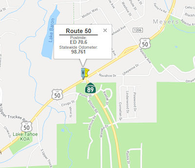 In March 2017, the CTC approved for future consideration of funding a project located in El
Dorado County near the town of Meyers (03-ED-89, PM 8.592; 03-ED-50 PM
70.62) that proposes to convert the US 50/Route 89 intersection into a
three-leg roundabout. The proposed roundabout will have single lane
approaches on all three legs to reduce the number and/or severity of
collisions. This project is programmed in the 2016 SHOPP for $5,240,000 in
Construction (capital and support) and Right of Way (capital and support).
Construction is estimated to beginning in Fiscal Year 2017-18. The scope,
as described for the preferred alternative, is consistent with the project
scope programmed by the Commission in the 2016 State Highway Operation and
Protection Program.
In March 2017, the CTC approved for future consideration of funding a project located in El
Dorado County near the town of Meyers (03-ED-89, PM 8.592; 03-ED-50 PM
70.62) that proposes to convert the US 50/Route 89 intersection into a
three-leg roundabout. The proposed roundabout will have single lane
approaches on all three legs to reduce the number and/or severity of
collisions. This project is programmed in the 2016 SHOPP for $5,240,000 in
Construction (capital and support) and Right of Way (capital and support).
Construction is estimated to beginning in Fiscal Year 2017-18. The scope,
as described for the preferred alternative, is consistent with the project
scope programmed by the Commission in the 2016 State Highway Operation and
Protection Program.
In May 2018, it was reported that a three-year, $56.9
million project (2018 is the second year) involves rebuilding a 2-mile
stretch of U.S. 50 from the "Y" with Route 89 (03-ED-89, PM 8.592;
03-ED-50 PM 70.62) to Trout Creek Bridge (ED 077.33). The rebuilding
includes widening the roadway to provide 6-foot shoulders for bike lanes
in both directions, replacing traffic signals, rebuilding curbs, gutters
and sidewalks, and improving the pavement cross slope, according to
Caltrans. Aside from aesthetic improvements, the project also is designed
to help lake clarity by building drainage systems to treat stormwater
runoff. It is part of the larger Lake Tahoe Environmental Improvement
Program, a multi-agency effort created to protect and improve the natural
and recreational resources of the Lake Tahoe Basin. Work in summer 2018
will stretch from Winnemucca Avenue to Silver Dollar Avenue, in addition
to repaving the Y intersection, according to Caltrans. Work will start at
Winnemucca and move east.
(Source: Tahoe Daily Tribune, 5/2/2018)
In June 2018, the CTC was informed of the following allocation: 2.5f(3) Item 2: $4,973,000 03-ED-50 70.6. PPNO 3303. US 50 Near Myers, at the intersection with Route 89 South. Outcome/Output: Improve safety by constructing a 3-leg roundabout with a bypass lane in the westbound direction at a two-way stop controlled intersection. This project will reduce the number and severity of collisions.
In November 2018, it was reported that in the 2018
construction season, Caltrans completed Phase Two of the three-phase "Y to
Trout Creek Bridge Project" that is reconstructing US 50 from the "Y"
intersection with Route 89 to the Trout Creek Bridge. Phase Two focused on
the stretch of highway from Winnemucca Avenue to Silver Dollar Avenue. As
part of the Lake Tahoe Environmental Improvement Program, this project was
designed to protect Lake Tahoe's water quality by rebuilding underground
storm drain systems. Now, storm water runoff is captured and filtered to
keep dirt, oil and litter from reaching the lake. Additional community
benefits include widening the highway to provide 6-foot shoulders for
safer bike access as well as new traffic signals at the intersection of
Lodi Avenue and US 50. Sidewalks on both sides of the highway have also
been reconstructed. In 2019, the final phase of the Y to Trout Creek
Bridge Project will focus on Phase Three, from Silver Dollar Avenue to the
Trout Creek Bridge, with a projected completion date of winter 2019. 2019
will also bring work in Meyers, where Caltrans will replace the existing
T-intersection at Route 89 and US 50 with a three-leg roundabout.
Currently, the junction just past the weigh-in station does not have
traffic stops controlling vehicle flow. This project was designed to
improve safety and reduce the number of collisions at the intersection.
(Source: Tahoe Daily Tribune, 11/11/2018)
In April 2019, it was reported that the project
will also include a westbound bypass lane, and should be completed in Fall
2019.
(Source: Tahoe Daily Tribune, 4/23/2019)
In September 2019, it was reported that the Caltrans
contractor working on the roundabout at the intersection of Route 89 and
US 50 has completed concrete work on the bypass lane. The $4.1M project
converted a T-intersection into a three-leg roundabout with a bypass lane.
(Source: South Tahoe Now, 9/6/2019)
In May 2018, it was reported that, following backlash in its first summer
of use and input from partner agencies, the pedestrian stoplight at Camp
Richardson is on indefinite hiatus (~ ED 11.158). The device was installed
in 2016 as part of a Caltrans construction project. It was mostly used in
the summer of 2017 as a means to help address traffic and pedestrian
issues. However, the light, which displayed a red signal to motorists when
pedestrians activated it to cross Route 89, was scrutinized by residents
and others who blamed the signal for worsening vehicle congestion. The
light was deactivated around the Fourth of July holiday (presumably in
2017, unless the author had time travel), when, according to Caltrans, a
significant increase in motorist and pedestrian activity led to congestion
in the area. Caltrans "decided to discontinue" the light "indefinitely"
after meeting with staff from the Tahoe Regional Planning Agency and U.S.
Forest Service. The light will remain off until the Route 89 Recreation
Corridor Management Plan is completed in 2019.
(Source: Tahoe Daily Tribune, 5/20/2018)
Meeks Creek Bridge Replacement (03-ED-89 24.4/25.3)
In August 2023, the CTC amended the 2022 SHOPP to add
the following project: 03-ED-89 24.4/25.3. PPNO 03-3473; ProjID
0323000082; EA 4J090. Route 89 Near Meeks Bay, at Meeks Creek Bridge
№ 25-0019. Replace Meeks Creek Bridge, restore creek to address
bridge scour and fish passage barriers, and add bicycle and pedestrian
improvements. Concurrent COS allocation under Resolution FP-23-16; August
2023. Allocation ($ × 1,000): PA&ED $2,000; PS&E $2,990; R/W
Sup $340; Con Sup $2,790; R/W Cap $1,550; Const Cap $15,400; TOTAL
$25,070. FY23-24 through FY25-26. Begin Const: 10/19/2026.
(Source: August 2023 CTC Agenda, Agenda Item 2.2a.(1a) #51)
In August 2023, the CTC approved the following SHOPP
Pre-Construction Phase (environmental support, design, and R/W support)
allocation: $1,042,000. 03-ED-89 24.4/25.3. PPNO 03-3473; ProjID
0323000082; EA 4J090. Route 89 Near Meeks Bay, at Meeks Creek Bridge
№ 25-0019. Replace Meeks Creek Bridge, restore creek to
address bridge scour and fish passage barriers, and add bicycle and
pedestrian improvements. Concurrent Amendment under SHOPP Amendment
22H-011; August 2023. Allocation (Programmed / Allocated):
PS&E $730,000 / $800,000; R/W Sup $220,000 / $242,000.
(Source: August 2023 CTC Agenda, Agenda Item 2.5b.(2a) #5)
 There are plans to construct roadway improvements between
the El Dorado County Line (~ ED 27.8/PLA 0.0) to Route 28 (~ PLA 8.276).
This project is fully funded in the 2006 SHOPP. The total estimated
project cost is $85,300,000. Construction is estimated to begin in FY
2007-08. The project will involve the removal of mature vegetation and the
disturbance of existing wetlands. In addition, changes in the visual
character of the area in the form of new lighting resulted in a Mitigated
Negative Declaration being completed for this project.
There are plans to construct roadway improvements between
the El Dorado County Line (~ ED 27.8/PLA 0.0) to Route 28 (~ PLA 8.276).
This project is fully funded in the 2006 SHOPP. The total estimated
project cost is $85,300,000. Construction is estimated to begin in FY
2007-08. The project will involve the removal of mature vegetation and the
disturbance of existing wetlands. In addition, changes in the visual
character of the area in the form of new lighting resulted in a Mitigated
Negative Declaration being completed for this project.
Water Quality Improvement
In October 2011, the CTC approved $40,413,000 for a project in Tahoe City from 0.2 mile south of the El Dorado/Placer County Line (~ ED 27.181) to the Truckee River Bridge (~ PLA 008.48). The project will construct water quality collection and treatment facilities to meet the requirements of California Regional Water Quality Control Board. (Construction will take more than 3 years due to permit restriction on grading and soil disturbances between May1 to October 15 each year. Also, traffic restrictions are reduced between June 15th and Labor Day during the peak tourist season. Construction is estimated to begin Summer of 2012 and be completed by December 2015. As a result, the California Department of Transportation is also requesting 39 months to complete construction.)
In January 2012, the CTC approved for future consideration of funding a project in El Dorado County will implement water quality improvement measures on Route 89 from US 50 to Cascade Road in and near South Lake Tahoe. These improvements will comply with the National Pollutant Discharge Elimination System Permit requirements and implement elements of the Lake Tahoe Environmental Improvement Program. The project is programmed in the 2010 State Highway Operation and Protection Program (SHOPP). The total estimated project cost is $30,023,000 for capital and support. Construction is estimated to begin in Fiscal Year 2012-13. The scope, as described for the preferred alternative, is consistent with the project scope programmed by the Commission in the 2010 SHOPP.
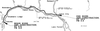
In April 2016, it was reported that work was resuming
on a multi-year Route 89 project. The $70.1 million water-quality
improvement project is building new drainage facilities to collect and
treat stormwater runoff, adding curbs and gutters, widening the highway
and repaving an eight-mile section of Route 89 between Tahoma and Tahoe
City. Work in the 2016 construction season focuses on the remaining four
miles of the project between Eagle Rock and Granlibakken Road. Caltrans
has two other water-quality improvement projects on Route 89 that will be
in construction in 2016 as part of the multi-agency Lake Tahoe
Environmental Improvement Program (EIP). A $24.4 million project from the
“Y” intersection with US 50 in South Lake Tahoe to Cascade
Road, north of Camp Richardson, is in its second season of construction
and will be completed in fall 2016. Picking up where that project ends,
the final segment of Route 89 to be rebuilt for drainage improvements will
be from Cascade Road to just north of the Eagle Falls Viaduct over Emerald
Bay. The $13 million project will take two seasons to construct. In
addition to the EIP projects, Route 89 from Tahoe City to Alpine Meadows
Road will be repaved this summer as part of ongoing preventive
maintenance.
(Source: Tahoe Roads, April 2016)
Fanny Bridge Project (Jct Route 89/Route 28) (~ PLA T8.542)
 It was also reported in September 2011 about plans to reconstruct the Fanny Bridge. The bridge
was constructed in 1920 and spans the Truckee River, Lake Tahoe's sole
outlet, near the at-times very congested pedestrian intersection at the
Wye intersection in Tahoe City. The project would rehabilitate Fanny
Bridge, while simultaneously addressing traffic congestion. Preliminary
plans feature four alternatives. Initially, the preferred option calls for
construction of a four-lane bridge to span the Truckee River farther west
from the current Fanny Bridge location. The bridge would be part of a new
road that would serve as the main ingress/egress route connecting Route 89
and Route 28. Roundabouts also would be installed at each intersection.
Meanwhile, Fanny Bridge's structural deficiencies will be addressed, and
the remaining stretch of Route 89 from the Wye to the intersection of the
newly built road will be transformed into a local neighborhood street,
with a variety of traffic calming features designed to dissuade motorists
from using the path as a primary means of travel. The other three
alternatives include changing the existing Route 89 just south of Fanny
Bridge into a pedestrian/bike trail; installing a cul-de-sac at the end of
that street; or conducting the project without roundabouts, respectively.
Planning level cost estimates call for a $13-18 million investment. The
project is slated to continue to solicit community input and feedback
throughout 2011 and develop a final design by 2012. Construction is
tentatively scheduled to commence in 2014.
It was also reported in September 2011 about plans to reconstruct the Fanny Bridge. The bridge
was constructed in 1920 and spans the Truckee River, Lake Tahoe's sole
outlet, near the at-times very congested pedestrian intersection at the
Wye intersection in Tahoe City. The project would rehabilitate Fanny
Bridge, while simultaneously addressing traffic congestion. Preliminary
plans feature four alternatives. Initially, the preferred option calls for
construction of a four-lane bridge to span the Truckee River farther west
from the current Fanny Bridge location. The bridge would be part of a new
road that would serve as the main ingress/egress route connecting Route 89
and Route 28. Roundabouts also would be installed at each intersection.
Meanwhile, Fanny Bridge's structural deficiencies will be addressed, and
the remaining stretch of Route 89 from the Wye to the intersection of the
newly built road will be transformed into a local neighborhood street,
with a variety of traffic calming features designed to dissuade motorists
from using the path as a primary means of travel. The other three
alternatives include changing the existing Route 89 just south of Fanny
Bridge into a pedestrian/bike trail; installing a cul-de-sac at the end of
that street; or conducting the project without roundabouts, respectively.
Planning level cost estimates call for a $13-18 million investment. The
project is slated to continue to solicit community input and feedback
throughout 2011 and develop a final design by 2012. Construction is
tentatively scheduled to commence in 2014.
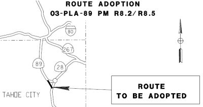
In August 2016, the CTC approved for future consideration of funding a project that realigns a segment of Route 89 with a replacement bridge and various other improvements including a roadway section replacement, pedestrian and bicycle improvements, roundabouts, and a complete streets element to address traffic, bicycle and pedestrian congestion (03-PLA-089 R8.2/R8.5). On April 10, 2015, the TDD adopted the FEIR for State Route 89 / Fanny Bridge Community Revitalization Project under CEQA. On July 15, 2016, the TTD confirmed that the FEIR remains valid and that there are no new identified impacts requiring mitigation since adoption. The TTD also confirmed that the preferred alternative set forth in the final environmental document is consistent with the Project scope of the work programmed by the Commission. The Project is estimated to cost $38,877,000 and is fully funded through construction with Federal Land Access Program (FLAP) Funds ($30,620,000), Active Transportation Program Funds ($4,900,000) and Local Funds ($3,357,000). Construction is estimated to begin in Fiscal Year 2016/17.
 At the same meeting, the CTC also approved Federal
Highway Administration’s Central Federal Lands Highway Division
(CFLHD) plans, in conjunction with Tahoe Transportation District (TTD), to
construct a new alignment for portion of Route 89 near Tahoe City through
United States Forest Service (USFS) property. This new alignment will
better serve the west shore communities of Lake Tahoe by providing an
option for the traveling public as they approach Tahoe City from the south
and from the west. The purpose of the route adoption is to improve safety
and operations of the existing Route 89/Route 28 intersection, improve
multimodal access with the creation of “complete streets”
elements, address long term bridge integrity by replacing the aged Fanny
Bridge, and contribute to economic revitalization by enhancing motorized
and non-motorized business access and safety, including delivery of goods
and services. This project brings about the highest and best beneficial
uses of USFS land and its associated modes of travel. The adopted route
will serve as a parallel route for the traveling public entering or
exiting the hub of Tahoe City. Route 89 serves the west shore communities
of Lake Tahoe, crosses the Truckee River at Fanny Bridge and connects to
Route 28 in Tahoe City, also known as the WYE intersection, before
continuing to the town of Truckee, California. Approaching the WYE
intersection from all three directions, this two-lane conventional highway
has historic congestion during the summer peak season with an unacceptable
Level of Service (LOS) “F”. The urban context of the WYE
intersection in Tahoe City adds to the congestion. During emergency
response to fire, police, or ambulatory calls, there is delay for
emergency crews to clear the WYE intersection. The physical and
environmental setting severely constrains any lane addition, or bridge
widening options to mitigate for the LOS “F”. The current
single route over the Truckee River has proven to be inadequate given the
aforementioned constraints. Bicycle and pedestrian activity are very close
to travel lanes on and around Fanny Bridge. Safety risks to pedestrian,
bicycle, and motorists result from inadequate multi-modal infrastructure
related to discontinuous bicycle paths, and the absence of pedestrian
facilities, compounded with heavy volumes of vehicular traffic, pedestrian
activity, and trail use. Current traffic congestion and inadequate travel
conditions in and around Fanny Bridge and the WYE intersection are the
primary reasons for the proposed realignment of Route 89. In addition,
this project also replaces the 1928 Fanny Bridge. The two new
intersections created by the new alignment, plus the existing WYE
intersection, will become roundabouts. These three roundabouts will
provide a decrease in traffic congestion and will accommodate multiple
modes of transportation in a safe manner. After construction of the new
Route 89 alignment, and with the Commission’s approval, a small
portion of this route will be redesignated as Route 28 extension and a
segment of the existing Route 89 from north of Fanny Bridge to the new
intersection south of the bridge will be relinquished to the County. The
County has signed a relinquishment agreement and is receiving a transfer
of possession and control of the new Fanny Bridge as part of their
inventory, post construction. State highway adoption of Route 89 occurred
on April 18, 1929. Freeway adoption of a portion of Route 89 occurred on
March 27, 1963. Rescinding of Freeway Declaration for said portion of
Route 89 occurred on June 20, 1974. Route 89 is part of the Freeway and
Expressway System. CFLHD is contributing $30.62 million and TTD with the
County are contributing a combined total match of $8.257 million.
At the same meeting, the CTC also approved Federal
Highway Administration’s Central Federal Lands Highway Division
(CFLHD) plans, in conjunction with Tahoe Transportation District (TTD), to
construct a new alignment for portion of Route 89 near Tahoe City through
United States Forest Service (USFS) property. This new alignment will
better serve the west shore communities of Lake Tahoe by providing an
option for the traveling public as they approach Tahoe City from the south
and from the west. The purpose of the route adoption is to improve safety
and operations of the existing Route 89/Route 28 intersection, improve
multimodal access with the creation of “complete streets”
elements, address long term bridge integrity by replacing the aged Fanny
Bridge, and contribute to economic revitalization by enhancing motorized
and non-motorized business access and safety, including delivery of goods
and services. This project brings about the highest and best beneficial
uses of USFS land and its associated modes of travel. The adopted route
will serve as a parallel route for the traveling public entering or
exiting the hub of Tahoe City. Route 89 serves the west shore communities
of Lake Tahoe, crosses the Truckee River at Fanny Bridge and connects to
Route 28 in Tahoe City, also known as the WYE intersection, before
continuing to the town of Truckee, California. Approaching the WYE
intersection from all three directions, this two-lane conventional highway
has historic congestion during the summer peak season with an unacceptable
Level of Service (LOS) “F”. The urban context of the WYE
intersection in Tahoe City adds to the congestion. During emergency
response to fire, police, or ambulatory calls, there is delay for
emergency crews to clear the WYE intersection. The physical and
environmental setting severely constrains any lane addition, or bridge
widening options to mitigate for the LOS “F”. The current
single route over the Truckee River has proven to be inadequate given the
aforementioned constraints. Bicycle and pedestrian activity are very close
to travel lanes on and around Fanny Bridge. Safety risks to pedestrian,
bicycle, and motorists result from inadequate multi-modal infrastructure
related to discontinuous bicycle paths, and the absence of pedestrian
facilities, compounded with heavy volumes of vehicular traffic, pedestrian
activity, and trail use. Current traffic congestion and inadequate travel
conditions in and around Fanny Bridge and the WYE intersection are the
primary reasons for the proposed realignment of Route 89. In addition,
this project also replaces the 1928 Fanny Bridge. The two new
intersections created by the new alignment, plus the existing WYE
intersection, will become roundabouts. These three roundabouts will
provide a decrease in traffic congestion and will accommodate multiple
modes of transportation in a safe manner. After construction of the new
Route 89 alignment, and with the Commission’s approval, a small
portion of this route will be redesignated as Route 28 extension and a
segment of the existing Route 89 from north of Fanny Bridge to the new
intersection south of the bridge will be relinquished to the County. The
County has signed a relinquishment agreement and is receiving a transfer
of possession and control of the new Fanny Bridge as part of their
inventory, post construction. State highway adoption of Route 89 occurred
on April 18, 1929. Freeway adoption of a portion of Route 89 occurred on
March 27, 1963. Rescinding of Freeway Declaration for said portion of
Route 89 occurred on June 20, 1974. Route 89 is part of the Freeway and
Expressway System. CFLHD is contributing $30.62 million and TTD with the
County are contributing a combined total match of $8.257 million.
In July 2018, it was reported that construction on the
new Truckee bridge had started, with expected completion in October 2018.
The project, originally conceptualized in the 1994 Tahoe City Community
Plan, is a new Truckee River bridge — a rebuild of Fanny Bridge. The
construction of three new roundabouts, the realignment of Route 89 to
match new road plans, and other street improvements along West Lake
Boulevard are all part of the bridge project. The new Truckee River
Bridge, located east of the Caltrans maintenance yard along Route 89 and
downstream of Fanny Bridge, will become the new junction between Route 89
and Nevada Rte 28. The 88-year-old Fanny Bridge will be rebuilt to include
new sidewalks and bike lanes on each side, with bridge railing that
matches the existing design. A new roundabout will be constructed on the
north side of the Truckee River with outlets onto the new bridge and West
River Street. Another roundabout will connect a new route from the new
bridge to West Lake Boulevard. The third roundabout will replace Tahoe
City's busiest intersection where the original junction between Route 89
and Route 28 currently stands. West Lake Boulevard also will receive
improvements including new sidewalks, crosswalks, street lights, and
street and trail signs. Two new Tahoe City gateway signs will be installed
at the two roundabouts leading into the city. The Tahoe City Trout
Sculpture has already been dismantled and moved to storage to allow for
construction. City officials are still making efforts to secure a new
location for the sculpture when the project is complete.
(Source: Sierra Sun, 6/28/2018)
In October 2019, it was reported that the project to
replace the Truckee River “Fanny” Bridge, enhance pedestrian
mobility, improve access to public transit and relinquish a section of
Route 89 to Placer County is planned for 2021. Short-term work at the
“Wye” intersection to reestablish pedestrian access and
erosion control is scheduled to be completed by the end of October 2019.
(Source: Caltrans District 3 Press Release, 10/28/2019)
In December 2019, it was reported that Caltrans joined
several partner agencies for a ribbon-cutting ceremony on the new Route 89
Truckee River Bridge in Tahoe City. The project includes roundabouts at
each end of the bridge and new bike path segments.
(Source: Facebook, 12/16/2019)
Northern End of Lake Tahoe (Route 28) to Truckee (I-80)
Tahoe to Truckee Repaving
In September 2011, it was reported that a portion of Route 89 connecting Tahoe City to Truckee will be repaved, shoulder to shoulder. The project will begin in Spring 2012, taking one construction season to complete. Funds from the California State Highway Operation Protection Program will be used. Repaving will start 0.2 miles south of the Squaw Valley USA exit (~ PLA 13.725) and end at the Nevada County state line near Truckee.
In March 2012, the CTC approved SHOPP funding for work near Truckee, from 0.2 mile south of Squaw Valley Road (~ PLA 13.515) to Nevada County line (~ PLA 21.642/NEV 0.0). $8,360,000 to rehabilitate 16 lane miles of pavement to improve ride quality and extend the pavement service life.
In October 2012, it was reported that the shoulder to shoulder repaving project on Route 89 between Squaw Valley Road to West River Street was completed. The $7.2 million project between Truckee and Olympic Valley improved the surface for bikes and motor vehicles, and included water quality protection from stormwater drainage while extending the pavement life an additional 10 years.
In August 2019, it was reported that, to help reduce peak ski weekend
traffic congestion into Squaw Valley and Alpine Meadows resorts, the
county is considering converting the road shoulders on Route 89 into a
third lane only accessible by public transit vehicles, encouraging the use
of those services. The project consists of two 2-mile bus-on-shoulder
zones in the highest congestion areas, specifically northbound beginning
north of Cabin Creek Road (~ PLA 18.956) to the West River Street
intersection (~ PLA 21.526) and southbound beginning south of the Pole
Creek Trailhead (~ PLA 16.042) to the Squaw Valley Road intersection (~
PLA 13.727). The schedule is dependent on Caltrans and California Highway
Patrol approval but is tentatively planned for winter 2019. If successful,
the program could lead to an extension to the full section of Route 89
between Olympic Valley and Truckee, and possible application on Route 267
between Northstar and Truckee.
(Source: Tahoe Daily Tribune, 8/14/2019)
In June 2016, it was reported that the Truckee North Tahoe Transportation
Management Association is starting discussions for a potential three-lane
program on Route 89 for the 2016-17 winter season in an effort to ease
traffic congestion. The program would be based on an existing program on
other roads that routes two lanes of traffic inbound to Squaw Valley
during the morning hours and two lanes outbound in the afternoon.
Physically speaking, fitting three lanes on Route 89 is possible, as Route 89 pinch points are 42 feet. Hurdles for the program include traffic
control, snow removal and condensed shoulder space. The program is viewed
as a limited experiment only used when there is no snowfall and the
shoulders are clear, similar to the preconditions used for the three lanes
at Squaw Valley Road (dry roadway surface, full road width).
(Source: Sierra Sun, 6/14/2016)
The SAFETEA-LU act, enacted in August 2005 as the reauthorization of TEA-21, provided the following expenditures on or near this route:
Naming The portion of the route between Truckee and Tahoe City is named the "10th Mountain Division Memorial Highway". The 10th Mountain
Division of the United States Army, consisting of 15,000 soldiers, served
gallantly in the Italian campaign during World War II. It had many members
from Sierra County. After the war, ex-soldiers from the 10th Mountain
Division fired-up America’s modern ski industry. They published ski
magazines, opened ski schools, and established ski areas, including Vail,
Aspen, Sugarbush, Whiteface Mountain and others. At least 62 ski resorts
have been founded, managed, or employed head ski instructors that were
10th Mountain Division veterans Named by Senate Concurrent Resolution 43,
Chapter 106, in 1997.
The portion of the route between Truckee and Tahoe City is named the "10th Mountain Division Memorial Highway". The 10th Mountain
Division of the United States Army, consisting of 15,000 soldiers, served
gallantly in the Italian campaign during World War II. It had many members
from Sierra County. After the war, ex-soldiers from the 10th Mountain
Division fired-up America’s modern ski industry. They published ski
magazines, opened ski schools, and established ski areas, including Vail,
Aspen, Sugarbush, Whiteface Mountain and others. At least 62 ski resorts
have been founded, managed, or employed head ski instructors that were
10th Mountain Division veterans Named by Senate Concurrent Resolution 43,
Chapter 106, in 1997.
(Information source: The Storm King; Image source: James D. Teresco/Ride from Auburn to Squaw Valley, California, Snow Brains)
 Named Structures
 Near Alpine Meadows Road is the "Allexey Waldemar Von Schmidt Historical
Plaque". It was designated by Senate Concurrent Resolution 75,
Chapter 105, in 1992. Allexy Waldemar Von Schmidt was a 19th century
Russian immigrant and civil engineer whose survey helped establish the
border between California and Nevada. Von Schmidt arrived in San Francisco
in 1849, but did not join the gold rush. Trained as a civil engineer at
American universities, Von Schmidt landed a job as a United States
surveyor, mapping public lands and Spanish land grants throughout the
state. Recognizing that “water flows uphill to money” and that
a limited fresh water supply threatened to curtail the growth of San
Francisco, Von Schmidt helped incorporate the Bensley Water Company. The
company successfully built San Francisco’s first water supply system
in the late 1850.. He later joined the rival Spring Valley Water Company,
and five years later, Spring Valley bought out the Bensley outfit and
established a profitable monopoly as the principal water purveyor to San
Francisco. In 1865, Von Schmidt and five other investors established the
Lake Tahoe and San Francisco Water Works Company to export the water of
Lake Tahoe to the Bay Area, a distance of 163 miles. When Von
Schmidt’s proposal was submitted to legislators in Sacramento and
Washington, D.C., it ran into strong resistance. Opponents argued that the
federal government had no business subsidizing private corporations by
giving away public lands.
Near Alpine Meadows Road is the "Allexey Waldemar Von Schmidt Historical
Plaque". It was designated by Senate Concurrent Resolution 75,
Chapter 105, in 1992. Allexy Waldemar Von Schmidt was a 19th century
Russian immigrant and civil engineer whose survey helped establish the
border between California and Nevada. Von Schmidt arrived in San Francisco
in 1849, but did not join the gold rush. Trained as a civil engineer at
American universities, Von Schmidt landed a job as a United States
surveyor, mapping public lands and Spanish land grants throughout the
state. Recognizing that “water flows uphill to money” and that
a limited fresh water supply threatened to curtail the growth of San
Francisco, Von Schmidt helped incorporate the Bensley Water Company. The
company successfully built San Francisco’s first water supply system
in the late 1850.. He later joined the rival Spring Valley Water Company,
and five years later, Spring Valley bought out the Bensley outfit and
established a profitable monopoly as the principal water purveyor to San
Francisco. In 1865, Von Schmidt and five other investors established the
Lake Tahoe and San Francisco Water Works Company to export the water of
Lake Tahoe to the Bay Area, a distance of 163 miles. When Von
Schmidt’s proposal was submitted to legislators in Sacramento and
Washington, D.C., it ran into strong resistance. Opponents argued that the
federal government had no business subsidizing private corporations by
giving away public lands.
(Image source and additional information: Sierra College)
 Route 80 near Truckee to Route 70 near Blairsden.
Post 1964 Signage HistoryThis segment is the original (c) from 1963.
The route between Satley and Sierraville is signed as Route 49, although it is legislatively Route 89. This results in signs for 49 North and 89 South ... and the reverse of this going the other way.
Pre 1964 Signage HistoryIn 1934, Route 89 was signed along the route from Jct. Route 7 (US 395) near Coleville to Jct. US 99 (I-5) near Mt. Shasta, via Truckee, Quincy, and Chester. This segment was part of LRN 83, defined in 1933. Originally, Route 70 was Alternate US 40.
StatusNorthern End of Truckee (Jct Route 267 / I-80) to Sierraville (Route 49)
A bypass for Route 267 around the Route 89/Route 267 interchange in Truckee was completed in 2004 to get all the Tahoe-bound traffic out of central Truckee. The Route 89 portion of the alignment is short (~ NEV R0.673); most of the bypass is for Route 267. The bypass includes a long viaduct across the Truckee River, which is visible as you come off the hill near the Central Truckee exit. This bypass is 2 lane expressway with sufficient right of way to expand it to 4 lanes when needed. From the old interchange, the east and west bound on ramp will remain to provide the town with direct highway access.
In August 2011, the CTC approved $6,000,000 in SHOPP funding, programmed in Fiscal Years 2012-13 and 2013-14, for repairs near Truckee, from the Nevada/Sierra County Line (SIE 0.0) to Junction Route 49 north of Sierraville that will rehabilitate 30.2 lane miles of roadway to improve the ride quality, prevent further deterioration of the traveling surface, minimize costly roadway repairs and extend the pavement service.
In October 2016, the CTC approved the following STIP allocation: 03-Sie-89 0/11.8 Route 89 Truck Pull-outs Sierra County to Sierraville. Construction of truck turnouts on Route 89 at 7 locations between Sierra/Nevada County line and Sierraville. $750,000
In May 2016, it was reported that the Highway 89 Stewardship Team
officially broke ground on the Sierra 89 Wildlife Undercrossings project
in a ceremony held at Sagehen Summit along Route 89 north of Truckee, near
Sagehen Creek Field Station (SIE 0.8 and SIE 1.4). The $2.8 million
project — funded by the State Highway Operation and Protection
Program (SHOPP) — will consist of the construction of two tunnels,
built as a pair, on the busy 25-mile stretch of Route 89 between Truckee
and Sierraville, providing a path for wildlife to cross this section of
the roadway. Additionally, 1.3 miles of wildlife fencing will be installed
along both sides of Route 89 to guide animals to the safe passage under
the highway. The data that pinpointed where the wildlife undercrossings
should be placed is the result of 27 years worth of data taken by
Caltrans. In fact, recent Caltrans studies indicate more than 1,000 mule
deer have been killed along Route 89 in the Loyalton-Truckee area over the
past 27 years, according to previous reports. Cost-benefit analysis have
shown that such undercrossings are a positive benefit to the taxpayer. The
cost of deer-vehicle collisions alone — not counting the other
species — is enough to where the project can actually break even in
a relatively few number of years. Caltrans environmental staff, in
conjunction with the Sierra 89 Stewardship Team partners, will monitor and
research the undercrossings for three years to study their effectiveness.
The project is the second in a series of planned mitigation and research
efforts by the Highway 89 Stewardship Team. The team’s first
wildlife undercrossing, on Route 89 at Kyburz Flat, was completed in 2009.
(Source: Sierra Sun, May 2016)
Caltrans completed its first standalone wildlife crossing in 2008 on
Route 89 at Kyburz Flat in the Sierra (~ SIE 3.977), about 20 miles north
of Truckee. The cost was $720,000 for the undercrossing (12-foot-high,
19-foot-wide steel arch) and $450,000 for fencing to guide the animals to
safety, according to Sara Holm, environmental scientist with the state
Department of Fish and Wildlife. Eight years later, data from the
California Highway Patrol found wildlife-vehicle collisions declined in
the Kyberz area, from 29 between 1999 to January 2009 to five between 2009
and 2015. Deer and other wildlife can now cross underneath the road
surface through a large culvert and avoid on-coming traffic. To encourage
wildlife to utilize the culvert, fencing was installed in the fall of 2013
to help funnel animals through the underpass. Wildlife that might still
enter the fencing and roadbed can climb out using the strategically placed
hill ramps or “jump outs” for escape.
(Source: Santa Cruz Sentinel, 5/12/2018, USFS Kyberg Flat/Hwy 89 Wildlife Mitigation, UC Natural Reserve System "Helping Wild Things Cross The Road", 9/28/2010)
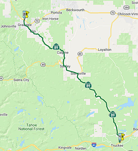
Sierraville (Route 49) to Blairsden (Route 70)
In October 2023, the CTC revised the following project in the 2022 SHOPP:
02-Plu-89 0.0/8.7. PPNO 02-3709; ProjID 0218000057; EA 3H950. Route 89
Near Graeagle, from Sierra County line to Route 70. Rehabilitate pavement,
raise the roadway grade, upgrade guardrail and signs, and
widen shoulders. Note: Update description and project costs to add scope
to realign and raise 1.1 mile section of the roadway to eliminate flood
water from the Middle Fork Feather River over-topping the roadway. This
will provide climate resiliency improvements and address historic and
future flooding events at this location. This additional need will be
funded through Infrastructure Investment and Jobs Act (IIJA) funds.
Allocation ($ × 1,000): PA&ED $1,290; PS&E $1,140
$1,900; R/W Sup $230 $500; Con Sup $2,210
$3,210; R/W Cap $591 $2,861; Const Cap
$11,200 $24,190; TOTAL $16,661 $33,951.
(Source: October 2023 CTC Agenda, Agenda Item 2.1a.(1d) #5)
In December 2008, the CTC vacated right of way in the county of Plumas along Route 89 near Whitehawk (~ PLU R2.007), consisting of highway right of way no longer needed for State highway purposes.
In July 2002, the CTC considered for future funding a project to realign Route 89 near Clio in Plumas County (~ PLU 4.42). [2.2c.(5)]
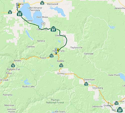 Route 70 near Indian Falls to Route 36 near Deer Creek Pass.
Post 1964 Signage HistoryThis segment is the original (d) from 1963.
The route between Blairsden and Indian Falls is cosigned as Route 70/Route 89, although it is legislatively Route 70.
Pre 1964 Signage HistoryIn 1934, Route 89 was signed along the route from Jct. Route 7 (US 395) near Coleville to Jct. US 99 (I-5) near Mt. Shasta, via Truckee, Quincy, and Chester. This segment was part of LRN 83, defined in 1933. Originally, Route 70 was Alternate US 40.
StatusIn June 2023, the CTC amended the following project in the 2022 SHOPP:
02-Plu-89 12.9/20.0. PPNO 02-3714; ProjID 0218000070; EA 4H030. Route 89
Near Greenville, from 1.4 miles north of Indian Falls Road to south of Hot
Springs Road; also from Mill Street to 0.4 mile north of Mill Street (PM
20.6/21.0). Rehabilitate pavement, upgrade guardrail, replace
Transportation Management System (TMS) elements and signs, rehabilitate
drainage systems, and construct a Maintenance Vehicle Pullout (MVP)
and a wildlife crossing. Note: Update the scope and description to
add a wildlife crossing. Increase construction capital because of
added wildlife crossing, greater than anticipated HMA cost, and other
items not originally accounted for including clearing and grubbing, and
stormwater BMPs. Decrease R/W capital because of a reduction of R/W
impacts. Allocation ($ × 1,000): PA&ED $670; PS&E $850;
R/W Sup $460; Con Sup $1,120; R/W Cap $363 $188;
Const Cap $9,410 $12,410; TOTAL $12,873
$15,698. FY23-24.
(Source: June 2023 CTC Agenda, Agenda Item 2.1a.(1d) #9)
Arlington Road Intersection Left Turn Lanes (02-Plu-089 14.600/15.200)
In March 2020, the CTC approved the 2020 STIP, which
included programmed funding of $1,616K (with the bulk of the work in
FY24-25) for PPNO 3561 "Rt 89/Arlington Rd intersection, left-turn lanes".
This would be ~ PLU 14.835.
(Source: March 2020 CTC Agenda, Item 4.7, 2020 STIP
Adopted 3/25/2020)
In December 2022, the CTC received notice of a
forthcoming STIP amendment (and in January 2023, voted on the amendment):
02-Plu-089 14.600/15.200. PPNO 02-3561; EA 4G700. Arlington Left Turn
Lane. On Route 89 In Plumas County at Crescent Mills from 0.3 miles
south to 0.2 mile north of Arlington Road. This project, Arlington Left
Turn Lane, proposes to Construct Left Turn Lane at Arlington Road. Because
of a change in design to widen asymmetrically to construct the left-turn
lane, post mile limits increased from 14.6/15.0 to 14.6/15.2. The project
was originally planned for symmetrical widening; however, preliminary
engineering and environmental studies revealed that this would negatively
impact environmentally sensitive areas, existing utilities, and the
railroad right of way. The amendment proposes to program $1,310,000 for
construction capital in Fiscal Year 2023-24 (an increase of $150,000) to
the STIP Arlington Left Turn Lane project (PPNO 3561), in Plumas
County. Construction capital cost increased by $150,000 from
$1,160,000 to $1,310,000. The increase is attributed to the following: (1)
A change in excavation type from roadway excavation to rock excavation to
asymmetrically widen the roadway to construct the left-turn lane (2)
Materials inflation (3) Additional clearing and grubbing adjacent to the
highway. The additional $150,000 is requested from Plumas County’s
unprogrammed Regional Improvement Program (RIP) share balance. This
amendment proposes to program an additional $150,000 for construction
capital in 2023-24 for a total of $1,310,000 to the Arlington Left Turn
Lane project (PPNO 3561), in Plumas County.Allocation ($ ×
1,000): PA&ED $170; PS&E $90; R/W Sup $40; Con Sup $140; R/W
Cap $16; Const Cap $1,310. Total $1,766.
(Source: December 2022 CTC Agenda, Agenda Item
2.1b.(1); January 2023 Agenda, Agenda Item 2.1a.(2))
In May 2023, the CTC received notice of the intent to
amend the STIP to reduce the CON phase programmed in 2023-24 with RIP
funds by $482,000 and add $482,000 in COVID-RIP funds. The Arlington Left
Turn Lane project (PPNO 3561) was identified as a financial partnership
project between the Plumas County Transportation Commission (PCTC) and the
Department - District 2 during the annual State Highway Needs meetings,
held in 2011. With the completion of another financial partnership
project, PCTC requested the Department to initiate a Project Study Report
(PSR) for the Arlington Left Turn Lane project, in preparation for the
2016 STIP cycle. There was a lack of funding in the 2016 STIP cycle and
the region's desire to reinstate programming in the 2018 STIP cycle.
The 2020 STIP cycle was the first time STIP/RIP programming was available
for the region to financially partner with the Department on the project.
Also, during this time, the Department’s Ten-Year plan had
identified a pavement need on this section of Route 89, in the 2020 State
Highway Operation and Protection Program (SHOPP). As such, PCTC and
the Department - District 2 identified a financial partnership between the
two projects and fund sources, allowing both projects to benefit from
economies of scale. In the 2020 STIP, CON Support and CON Capital
for the Arlington Left Turn Lane project were programmed in 2024-25, due
to a lack of programming capacity in the STIP in 2023-24. This was done
with the caveat that the CON Support and CON Capital would be moved to
2023-24 in the 2022 STIP to align with CON in the 2020 SHOPP project,
Crescent Mills Capital Preventive Maintenance project (PPNO 3875).
Unprogrammed shares from the Graeagle-Johnsville Road Reconstruction
project (PPNO 2548) are proposed to be programmed for the Arlington Left
Turn Lane Project (PPNO 3561). This funding swap is to ensure COVID-RIP
funds are allocated by June 30, 2024. In June 2023, the CTC approved a
STIP amendment for the Arlington Left Turn Lane project (PPNO 3561) to
reduce the CON phase programmed in 2023-24 with RIP funds by $482,000 and
add $482,000 in COVID-RIP funds.
(Source: May 2023 CTC Agenda, Agenda Item 2.1b.(2); June 2023 CTC
Agenda, Agenda Item 2.1a.(4))
In Janury 2013, the CTC approved amending the 2012 STIP to program $30,000 of Regional Improvement Program (RIP) Transportation Enhancement (TE) funds programmed by Modoc County (PPNO 2437) to Right of Way Support for the Greenville Route 89 Rehabilitation project (PPNO 3355) in Plumas County. The funds are needed to complete Right of Way (R/W) activities. This project is in Greenville, on Route 89 between Hideaway Road (~ PLU 19.803) and Mill Street (~ PLU 20.617). It will upgrade sidewalks and curb ramps to meet ADA requirements.
In March 2018, the CTC authorized relinquishment of right of way in the
county of Plumas along Route 89 (Crescent Street and Ann Street) at Ayoob
Alley (02-Plu-89-PM 20.4), consisting of collateral facilities. The
County, by letter dated November 14, 2017, agreed to accept title upon
relinquishment by the State. The 90-day notice period expired January 14,
2018.
(Source: CTC Agenda, March 2018 Agenda Item 2.3c)
In March 2016, the CTC approved for future consideration of funding a project in Plumas County that will construct new curb and gutter, drainage upgrades, a center turn lane, and other improvements on Route 89 in the city of Greenville (~ PLU 20.468). The project is programmed in the State Transportation Improvement Program. The total estimated cost is $5,397,000 for capital and support. Construction is estimated to begin in Fiscal Year 2016-17.
In August 2016, the CTC vacated right of way in the county of Plumas along Route 89 approximately 0.5 mile east of its intersection with Route 147 (02-Plu-89-PM 29.1), consisting of highway right of way no longer needed for State highway purposes.
 National Trails
 This route is part of the Volcanic Legacy Scenic Byway All American Road, between Route 147 and Route
36, and between Route 44 and I-5.
This route is part of the Volcanic Legacy Scenic Byway All American Road, between Route 147 and Route
36, and between Route 44 and I-5.
 Route 36 near Morgan Summit to Lassen Volcanic National Park.
Post 1964 Signage HistoryIn 1963, this segment was defined as "(e) Route 36 near Morgan to Lassen Volcanic National Park." In 1984, Chapter 409 changed "Morgan" to "Morgan Summit".
The route between Route 36 near Deer Creek Pass and Route 36 near Morgan Summit is cosigned as Route 36/Route 89, although it is legislatively Route 36.
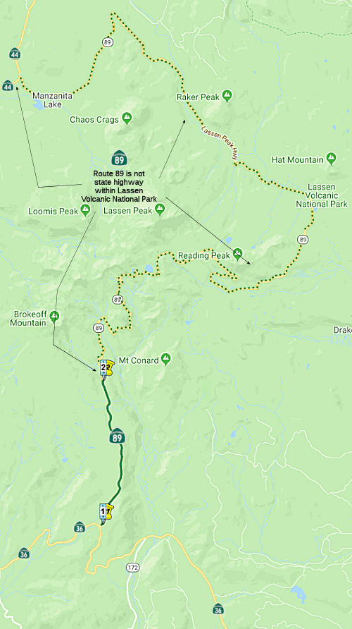
Note: The continuation of Route 89 along Lassen Peak Highway from the entrance of Lassen Volcanic National Park to Route 44 is not part of the State Highway Systems, although some maps show it as Route 89 and the NPS has occasionally posted it as Route 89. Historically, the route along Lassen Peak Highway was once signed by the California State Automobile Association. Some maps show the name as "Lassen Park Highway", but the NPS maps have "Lassen Peak Highway".
Lassen Peak Highway
During 1924 and 1925, the route of Lassen Peak Highway
was surveyed by National Park Service engineers. This culminated in
the construction of the first two miles of Lassen Peak Highway from the
Southwest Entrance to the Sulphur Works during 1925. By the 1930s,
the early Lassen Peak Highway can be seen stretching from Mineral
northward to the Sulphur Works. During 1926 the Park Service entered into
an agreement with the Bureau of Public Roads to construct Lassen Park
Highway. The Bureau of Public Roads made some alterations of the
original surveyed route of Lassen Park Highway but they were not
drastic. The original alignment of Lassen Park Highway was to be 16
feet wide and closely followed the Forest Service Road standards of the
time. Lassen Park Highway was completed during 1931 and a dedication
ceremony was held during July of said year. During 1933, LRN 83 was added
to the State Highway System. The first route segments of LRN 83 were
intended to connect to Lassen Park Highway from both terminus points.
(Source: Tom Fearer, Gribblenation Blog "Lassen Peak Highway; implied California State Route 89 through Lassen Volcanic National Park")
In 1934, the signed routes were announced. Signed Route 89 was added as a new highway that utilized LRN 83 from US 99 southeast
towards Truckee. Route 89 continued beyond Truckee via the west
shore Lake Tahoe to signed Route 7 over Monitor Pass. The
accompanying map to the accouncement shows signed Route 89 was intended to
be routed via Lassen Peak Highway through Lassen Volcanic National Park.
Between 1948 and 1953 Lassen Park Highway was widened to a minimum
standard of 20 feet and culminated in the road being completely
paved. During 2006 Lassen Park Highway was added to the National
Register of Historic Places.
(Source: Tom Fearer, Gribblenation Blog "Lassen Peak Highway; implied California State Route 89 through Lassen Volcanic National Park")
Pre 1964 Signage HistoryIn 1934, Route 89 was signed along the route from Jct. Route 7 (US 395) near Coleville to Jct. US 99 (I-5) near Mt. Shasta, via Truckee, Quincy, and Chester. This segment was part of LRN 83.
StatusThe continuation of this route through Lassen Volcanic National Park is occasionally closed in winter; a park fee is charged when it is open.
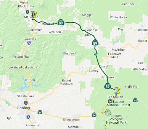 Route 44 to Route 5 near Mt. Shasta.
Post 1964 Signage HistoryThis segment is the original (f) from 1963.
Pre 1964 Signage HistoryIn 1934, Route 89 was signed along the route from Jct. Route 7 (US 395) near Coleville to Jct. US 99 (I-5) near Mt. Shasta, via Truckee, Quincy, and Chester. This segment was part of LRN 83, defined in 1933.
StatusIn May 2008, the CTC considered approval for future consideration of funding a bridge replacement (Lake Britton Bridge) (~ SHA 29.261) near McCloud for which a Mitigated Negative Declaration (MND) has been completed. The project will involve construction activities in an area that is habitat to three federally listed special-status species and one state species of special concern. These species include the Bald Eagle, Northern Spotted Owl, Rough Sculpin, and the Osprey.
In May 2008, the CTC considered relinquishment of right of way in the county of Shasta, at County Road No. 9S01 (McArthur Road) (~ SHA 38.779), consisting of a reconstructed and relocated county road.
In October 2009, the CTC approved vacation of right of way in the county of Siskiyou along Route 89 between 0.1 mile west and 0.1 mile east of Dead Horse Canyon Road (~ SIS 3.425 to SIS 3.625), consisting of highway right of way no longer needed for State highway purposes.
Named Structures On the northbound and southbound portions of Route 89, in the vicinity of mile
post markers 89 SHA 36.00 and 89 SHA 41.00, in the unincorporated area of
Shasta County, there are memorials in memory of "California Highway
Patrol Officer Arthur E. Dunn". On July 9, 1977, while transporting
a prisoner to jail on Route 89 in Shasta County, Officer Dunn was shot and
killed by a prisoner. He had joined the California Highway Patrol in March
1963, graduated from the patrol academy and was assigned to the West Los
Angeles area on July 5, 1963. He transferred to the Sacramento area on
December 3, 1965, the Redding area on October 11, 1967, and was assigned
to the Burney Resident Post in July 1968. The memorial was established in
memory of Officer Dunn as a result of his steadfast dedication to the
citizens of the State of California, and his commitment and contributions
to the safety of the motoring public. Named by Senate Concurrent
Resolution 85, Chapter 125, on August 21, 2002
On the northbound and southbound portions of Route 89, in the vicinity of mile
post markers 89 SHA 36.00 and 89 SHA 41.00, in the unincorporated area of
Shasta County, there are memorials in memory of "California Highway
Patrol Officer Arthur E. Dunn". On July 9, 1977, while transporting
a prisoner to jail on Route 89 in Shasta County, Officer Dunn was shot and
killed by a prisoner. He had joined the California Highway Patrol in March
1963, graduated from the patrol academy and was assigned to the West Los
Angeles area on July 5, 1963. He transferred to the Sacramento area on
December 3, 1965, the Redding area on October 11, 1967, and was assigned
to the Burney Resident Post in July 1968. The memorial was established in
memory of Officer Dunn as a result of his steadfast dedication to the
citizens of the State of California, and his commitment and contributions
to the safety of the motoring public. Named by Senate Concurrent
Resolution 85, Chapter 125, on August 21, 2002
(Image source: California Assn of Highway Patrolmen)
Pre 1964 Signage HistoryThis is all the original routing of Route 89, and dates back to the original signage of the route in 1934. The portion between US 395 and Route 4 was in the planning stages in 1935. The portion between Boca and Route 49 was under construction.
Freeway[SHC 253.1] Entire route. Added to the Freeway and Expressway system in 1959.
 Scenic Route
[SHC 263.1] Entire route.
 Blue Star Memorial Highway
This route was designated as a "Blue Star Memorial Highway" by Assembly Concurrent Resolution 111, Ch. 96 in 1986.
National Trails Portions of this route approximate the National Pony Express Trail, specifically the segments between US 50 and Route 88 near
Sorensens, although some segments veer of the current route onto older
routings.
Portions of this route approximate the National Pony Express Trail, specifically the segments between US 50 and Route 88 near
Sorensens, although some segments veer of the current route onto older
routings.
 Interregional Route
[SHC 164.14] Entire route.
 Other WWW Links
 Statistics
Overall statistics for Route 1:
 Pre-1964 Legislative Route
In 1933, a segment from "[LRN 49] near Middletown to [LRN 15] near Upper Lake via Lakeport" was added to the highway system. In 1935, this was defined to be LRN 89, with that same definition. This definition remained unchanged until the 1963 renumbering. This was originally (circa 1934) signed as part of Route 29; it is present-day Route 175 between Middletown and 4 mi SE of Kelseyville; cosigned Route 175/Route 29 (legislative Route 29) to 6 mi NW of Kelseyville, and Route 29 the remainder of the way to Route 20.
© 1996-2020 Daniel P. Faigin.
Maintained by: Daniel P. Faigin
<webmaster@cahighways.org>.
 Route 88
 Route 90